Combining a Fuzzy Matter-Element Model with a Geographic Information System in Eco-Environmental Sensitivity and Distribution of Land Use Planning

Abstract
:1. Introduction
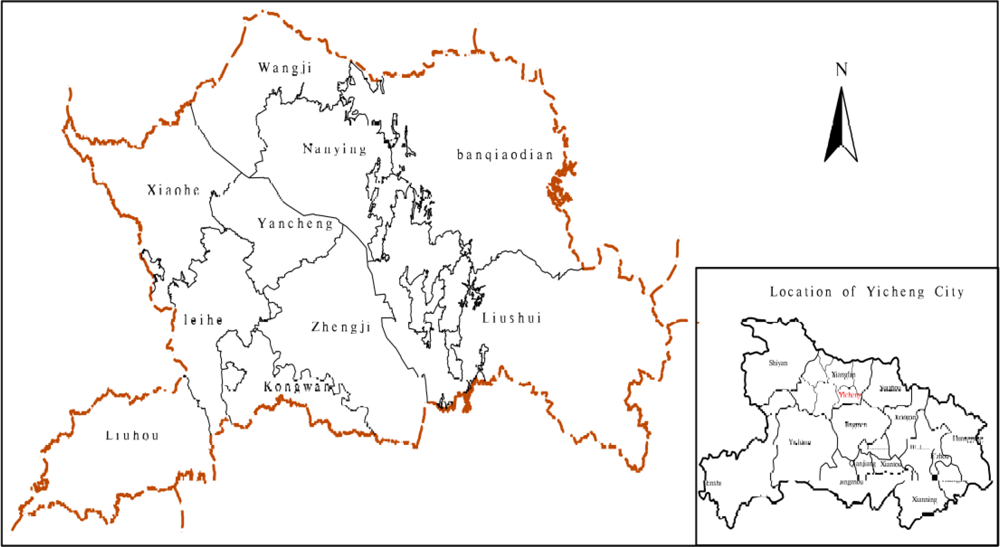
2. Study Area
3. Methodology
3.1. Establishment of the Evaluation Index System
3.2. The Evaluation Index and Gradation
3.3. Evaluation Methods and Model of Synthetic Eco-Environmental Sensitivity
3.3.1. Fuzzy Matter-Element Model
(1) Compound fuzzy matter-element model
(2) The principle on the excellent dependent degree
(3) Standard fuzzy matter-element and fuzzy matter element of different squares
(4) Weight of evaluation factors
- Assuming the amount of the evaluated objects is m, the amount of the evaluated index is n, to establish the estimation matrix R:
- The corresponding estimation matrix R is ranked and obtained the total ranking matrix B. The factor of matrix as:where rmax and rmin respectively represent the best and the worst of different things in the same evaluation index, which means the bigger, the more satisfied or the smaller, the more satisfied.
- According to the concept of entropy, it defines the entropy including m evaluation indexes and n evaluation indexes:The concept of fij is as follows:When fij = 0, Lnfij is inanition, so the calculation must be corrected. The concept is as follows:
- Calculate weigh of index w and entropy weight wi:and
(5) Euclid approach degree and synthetic evaluation
3.3.2. The GIS Technique Route and Factor-Overlay Method
3.3.3. Operation Model of Multi-Factor Vector Data
- Due to its ability to assign proper weights to various factors in complex systems, the eco-environment system was suitable for use in the entropy method, which was introduced in Section 3.3.1.
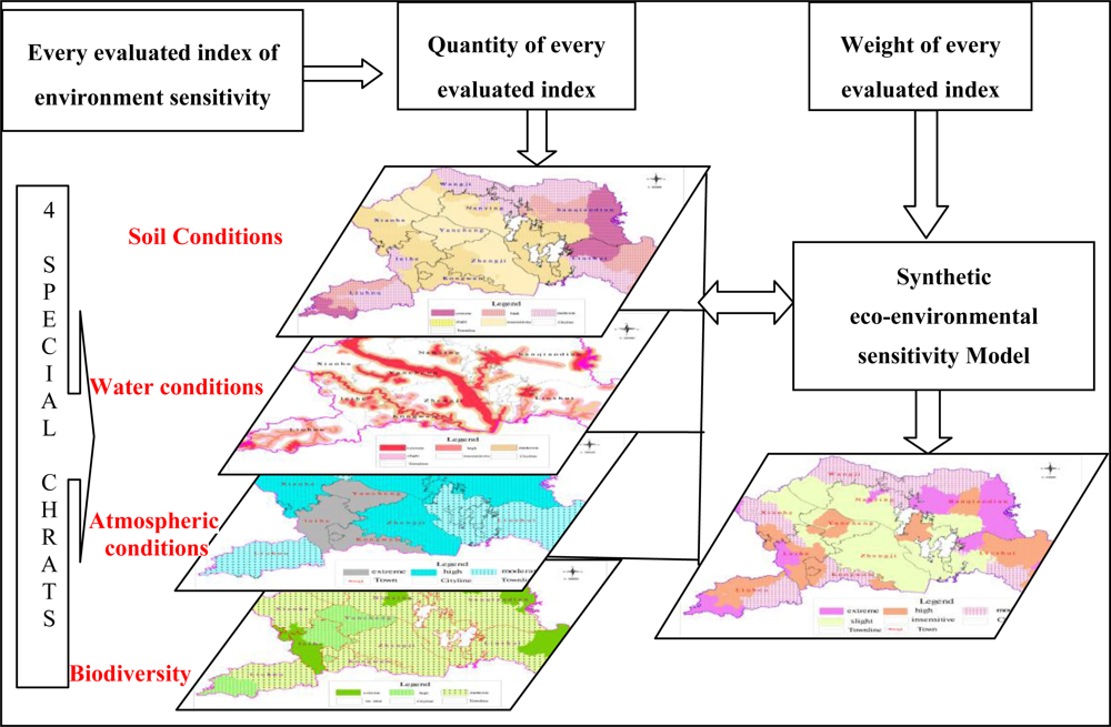
- The operation model of multi-factor vector data was constructed. Synthetic evaluation of ecological sensitivity on land use planning should synthetically consider every kind of evaluation index, including soil conditions, water conditions, atmospheric conditions and biodiversity. The formulation below was adopted to calculate the index grade of ecological sensitivity and to comprehensively evaluate the whole environmental sensitivity on the basis of the index grades. The formulation was as follows [15]:where Gi was the synthetic index value of every factor on B layer, gi was the value of each index, wj was the weight of each index, and n was the total number of indices, i = 1, 2, 3,…, n.
4. Results and Discussion
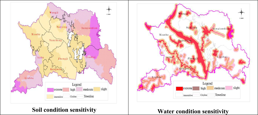
4.1. Sensitivity of Soil Conditions
4.2. Sensitivity of Water Conditions
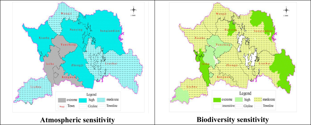
4.3. Sensitivity of Atmospheric Conditions
4.4. Biodiversity Sensitivity
4.5. Synthetic Evaluation and Space Distribution of Eco-Environmental Sensitivity
5. Conclusions
- It was proven that the spatial-overlay analysis for ecological sensitivity research was efficient and accurate. GIS was able to quickly and accurately extract a variety of basic information of ecological and environmental aspects, generate and update thematic maps of different ecological factors in different phases. Dynamic changes of the ecological environment obtained from the study area were very important to improve the eco-environmental management efficiency of the Land-Use Planning Department and Environmental Protection Department [18].
- On the basis of the fuzzy set theory and the concept of Euclid approach degree, a fuzzy matter-element model for environmental impact assessment in general land use planning was established. A case study was carried out which the fuzzy matter-element model was used to assess the eco-environmental quality in a small scale region. The study results showed that the fuzzy matter-element method was practical and reliable. It applied a new method to environment impact assessment for general land use planning.
References
- Ouyang, ZY; Wang, XK; Miao, H. China’s eco-environmental sensitivity and its spatial hetergeneity. Acta Ecologica Sinica 2000, 20, 9–12. [Google Scholar]
- Cameron, A; Johnston, RJ; McAdam, J. Classification and evaluation of spider (Araneae) assemblages on environmentally sensitive areas in Northern Ireland. Agr. Ecosyst. Environ 2004, 102, 29–40. [Google Scholar]
- Satti, SR; Jacobs, JM; Irmak, S. Agricultural water management in a humid region: Sensitivity to climate, soil and crop parameters. Agr. Water Manag 2004, 70, 51–65. [Google Scholar]
- Liu, K; Ouyang, ZY; Wang, XK. Eco-environmental sensitivity and its spatial distribution in Gansu privince. Acta Ecologica 2003, 23, 2711–2718. [Google Scholar]
- Jin, YH; Zhao, DS; Yan, QS. A study on distribution and division of sensitivity to ecological environment in Jinlin province. J. Northeast Norm. Univ 2004, 36, 68–74. [Google Scholar]
- Li, DM; Wu, XQ; Yu, DY. Evaluation on eco-environmental sensitivity of Yunnan province. Acta Ecologica 2008, 28, 5270–5278. [Google Scholar]
- Li, JY; Wu, JF. GIS-based assessment of sensitivity of land eco-environment in Shanxi province. Agr. Res. Arid Area 2007, 25, 19–25. [Google Scholar]
- Cao, HY. An initial study on DPSIR Model. Environ. Sci. Tech 2005, 6, 110–111. [Google Scholar]
- Yu, BH; Lu, CH. Application of DPSIR framework for analysis of sustainable agricultural development. China Popul. Res. Environ 2004, 14, 68–72. [Google Scholar]
- Wang, CJ; Tang, XH; Zheng, DX; Chen, WH. A GIS-based study on sensitivity of soil erosion. Bull. Soil Water Conserv 2005, 25, 68–71. [Google Scholar]
- Gobin, A; Jones, R; Kirkby, M; Campling, P; Govers, G; Kosmas, C; Gentile, AR. Indicators for pan-european assessment and monitoring of soil erosion by water. Environ. Sci. Policy 2004, 7, 25–38. [Google Scholar]
- Statistical Yearbook of Yicheng in 2008; Statistics Bureau of Yicheng City: Yicheng City, China, 2008; pp. 13–16.
- Cui, J. Fuzzy matter-element model based on coefficients of entropy and application in comprehensive evaluation of air quality. J. Taizhou Polytechnical Institute 2006, 6, 60–63. [Google Scholar]
- Liu, N; Ai, NS; Zhou, B. Entropy-based fuzzy matter-element model for evaluation urban human settlement and its application. Build. Sci 2007, 23, 45–52. [Google Scholar]
- Pan, JH; Dong, XF. GIS-based assessment and division on eco-environmental sensitivity in Heihe river basin. J. Nat. Resour 2006, 21, 267–274. [Google Scholar]
- Xiong, Y; Zeng, GM. Combining AHP with GIS in synthetic evaluation of eco-environment quality—A case study of Hunan province, China. Ecol. Model 2007, 209, 97–109. [Google Scholar]
- Xu, FL; Cao, J; Tao, S; Fu, MX. Analysis of sensitivity factors and regions for sustainable development of regional ecosystem. China Environ. Sci 2000, 20, 361–365. [Google Scholar]
- Liu, K; Xu, WH; Ouyang, ZY; Wang, XK. GIS-based assessment on sensitivity to land desertification in Gansu province. Bull. Soil Water Conserv 2002, 9, 29–31. [Google Scholar]


| A layer | B layer | C layer | D layer (unit) | Insensitive | Slightly sensitive | Moderately sensitive | High sensitive | Extremely sensitive |
|---|---|---|---|---|---|---|---|---|
| Eco-environmental sensitivity index | Soil conditions | Soil and water loss | Rainfall erosion (MJ·mm/hm2·h) | ≤25 | 25∼100 | 100∼400 | 400∼600 | ≥600 |
| Vegetation type | Water, swamp, paddy-field | Forest, meadow, pour-cluster | Sparse shrub plain | Hungriness | Non-vegetation | |||
| Grade and Slope (°) | 0∼5 | 6∼10 | 11∼15 | 15∼25 | ≥25 | |||
| Soil texture class | Silty soil, silt | Sandy loam, silty clay, loam clay | Sandy soil, loam soil | Sandy soil, clay | Stone soil, sandy soil | |||
| Soil quality | Soil type | Paddy soil | Damp soil | Yellow-Brown Soil | Purple soil | Calcareous soil | ||
| Landform and physiognomy | Plain | Plain, hill | Hill | Hill, mountains | Mountains | |||
| pH | ≤5.5 | 5.5∼6.5 | 6.5∼7.5 | 7.5∼8.5 | ≥8.5 | |||
| Hg (ppm) | ≤0.15 | 0.15∼0.30 | 0.30∼0.50 | 0.50∼1.0 | 1.0∼1.5 | |||
| Zn (ppm) | ≤100 | 100∼200 | 200∼250 | 250∼300 | 300∼500 | |||
| Ni (ppm) | ≤40 | 40∼50 | 50∼60 | 60∼70 | 70∼200 | |||
| HCHs (1) (ppm) | ≤0.05 | 0.05∼0.15 | 0.15∼0.3 | 0.3∼0.5 | 0.5∼1.0 | |||
| Groundwater Depth(m) | ≥200 | 100∼200 | 60∼100 | 40∼60 | ≤40 | |||
| Land use /land cover | Water, beach, swamp, paddy-field | Woodland, shrubberyland | Scanty-woodland, garden, meadow | Dry land, rural residential land | Non-vegetation land | |||
| Influence intensity of land use | ≤50 | 50∼60 | 60∼70 | 70∼80 | ≥80 | |||
| Water conditions | Water quality | Water sort | I | II | III | IV | V | |
| BOD (2) (mg/L) | 2 | 3 | 5 | 10 | 80 | |||
| CODMn (2) (mg/L) | 2 | 4 | 6 | 10 | 80 | |||
| Ammonia and nitrogen(mg/L) | 0.1 | 0.2 | 1.0 | 2.0 | 8.0 | |||
| Cr∼(6+)(mg/L) | 0.01 | 0.03 | 0.05 | 0.08 | 0.1 | |||
| Supply function of resource | Other used-water zone | Used-water zone of ecological forest and grass | Industrial used-water zone | Used-water zone of forest, fruit, animals, fishery | Drinking water zone, Water source zone | |||
| Index of eco-environmental sensitivity | Water condition | Exchange intensity of water | I | II | III | IV | V | |
| Distance to water source (m) | ≤200 | 200∼400 | 400∼600 | 600∼800 | ≥800 | |||
| Quality of protection layer | I | II | III | IV | V | |||
| Atmosphere condition | Content of SO2(Daily Mean)(3) (mg/L) | ≤0.05 | 0.05∼0.15 | 0.15∼0.20 | 0.20∼0.25 | ≥0.25 | ||
| Content of NO2(Daily Mean)(3) (mg/L) | ≤0.08 | 0.08∼0.09 | 0.09∼0.10 | 0.10∼0.12 | ≥0.12 | |||
| TSP (3) (mg/L) | ≤0.12 | 0.12∼0.2 | 0.20∼0.30 | 0.30∼0.50 | ≥0. 50 | |||
| PM10 (3) (mg/L) | ≤0.05 | 0.05∼0.10 | 0.11∼0.15 | 0.16∼0.25 | ≥0. 25 | |||
| Disposal ratio of industrial gas (%) | ≥90 | 80∼90 | 70∼80 | 60∼70 | ≥60 | |||
| Pollution burden | Low | Relatively low | Middle | Relatively high | Quite high | |||
| Population intensity(person/km2) | ≤2,000 | [2,000, 4,000] | [4,000, 6,000] | [6,000, 10,000] | ≥10,000 | |||
| Biodiversity | High degree of non-living environment | Temperature of annual average(°C) | 16 | 15 | 14 | 13 | 12 | |
| Quantity of rainfall(mm) | 1,000–1,050 | 1,050–1,100 | 950–1,000 | 900–950 | 850–900 | |||
| Abundance of biological resource | Protection Wildlife of national and province rank /marsh species | Unprotected species | Other protected species at province and regional level | Other protected species of nationality level | Marsh (without first and second level) | First and second level of nationality | ||
| Cover ratio of vegetation (%) | 25–30 | 20–25 | 15–20 | 10–15 | 5–10 | |||
| Biological diversity | ≥1.8 | 1.6∼1.8 | 1.4∼1.6 | 1.2∼1.4 | 1.0∼1.2 | |||
| Degree of social and economic development | Average fixed assets investment | 1 | 0.8 | 0.6 | 0.4 | 0.2 | ||
| Average net income (dollar) | 1,500 | 1,200 | 1,000 | 850 | 780 | |||
| Engle coefficient; (%) | 30 | 40 | 50 | 60 | 80 | |||
| Urbanization level; (%) | 20–30 | 20–25 | 15–20 | 10–15 | <10 | |||
| Evaluation | 1∼3 | 3∼5 | 5∼7 | 7∼9 | 9∼10 | |||
| Type of sensitivity | Sensitivity index | Area (hm2) | Proportion (%) |
|---|---|---|---|
| Insensitive | 1 | 56,722.69 | 27.65 |
| Slightly | 3 | 61,215.37 | 29.84 |
| Moderately | 5 | 38,218.58 | 18.63 |
| Highly | 7 | 28,535.72 | 13.91 |
| Extremely | 9 | 20,452.99 | 9.97 |
| Type of sensitivity | Sensitivity index | Area (hm2) | Proportion (%) |
|---|---|---|---|
| Moderately | 5 | 76,695.35 | 37.39% |
| Highly | 7 | 97,184.32 | 47.37% |
| Extremely | 9 | 31,265.67 | 15.24% |
| Type of sensitivity | Sensitivity index | Area (hm2) | Proportion (%) |
|---|---|---|---|
| Moderately | 5 | 143,929.76 | 70.16% |
| Highly | 7 | 17,770.25 | 8.66% |
| Extremely | 9 | 43,445.33 | 21.18% |
| A layer | Weight (w) | B layer | Weight (w) | C layer | Weight (w) | D layer |
|---|---|---|---|---|---|---|
| Index of eco-environmental sensitivity | 0.26 | Soil conditions | 0.2 | Soil and water loss | 0.2 | Rainfall erosion (MJ·mm/hm2·h) |
| 0.2 | Vegetation type | |||||
| 0.25 | Grade and Slope (°) | |||||
| 0.35 | Soil texture class | |||||
| 0.32 | Soil quality | 0.24 | Soil type | |||
| 0.18 | Landform and physiognomy | |||||
| 0.18 | pH | |||||
| 0.09 | Hg (ppm) | |||||
| 0.09 | Zn (ppm) | |||||
| 0.08 | Ni (ppm) | |||||
| 0.08 | HCHs (ppm) | |||||
| 0.08 | Groundwater Depth (m) | |||||
| 0.28 | Land use /land cover | |||||
| 0.2 | Influence intensity of land use | |||||
| 0.24 | Water conditions | 0.25 | Water quality | 0.55 | Water sort | |
| 0.12 | BOD (mg/L) | |||||
| 0.11 | CODMn (mg/L) | |||||
| 0.11 | Ammonia and nitrogen (mg/L) | |||||
| 0.11 | Cr∼(6+) (mg/L) | |||||
| 0.12 | Supply function of resource | |||||
| 0.18 | Exchange intensity of water | |||||
| 0.23 | Distance to water source (m) | |||||
| 0.22 | Quality of protection layer | |||||
| 0.28 | Quality grade of air | |||||
| 0.23 | Atmospheric conditions | 0.14 | Content of SO2(Daily Mean) (mg/L) | |||
| 0.13 | Content of NO2(Daily Mean) (mg/L) | |||||
| 0.12 | TSP (mg/L) | |||||
| 0.11 | PM10 (mg/L) | |||||
| 0.10 | Disposal ratio of industrial gas (%) | |||||
| 0.12 | Pollution burden (person/km2) | |||||
| 0.27 | Biodiversity | 0.28 | High degree of non-living environment | 0.48 | Temperature of annual average (°C) | |
| 0.52 | Quantity of rainfall (mm) | |||||
| 0.38 | Abundance of biological resource | 0.31 | Protection Wildlife of national and province rank /marsh species | |||
| 0.42 | Cover ratio of vegetation (%) | |||||
| 0.27 | Biological diversity | |||||
| 0.34 | Degree of social and economic development | 0.18 | Average fixed assets investment | |||
| 0.18 | Average net income (dollar) | |||||
| 0.47 | Engle coefficient (%) | |||||
| 0.17 | Urbanization level (%) | |||||
| Type of sensitivity | Sensitivity index | Area (hm2) | Proportion (%) | Feasible land type |
|---|---|---|---|---|
| Slight | 3 | 60,497.36 | 29.49 | Feasible zone |
| Moderate | 5 | 53,317.27 | 25.99 | Feasible zone |
| High | 7 | 61,789.78 | 30.12 | Dominated zone |
| Extreme | 9 | 29,540.93 | 14.4 | Protected zone |
© 2011 by the authors; licensee MDPI, Basel, Switzerland. This article is an open-access article distributed under the terms and conditions of the Creative Commons Attribution license (http://creativecommons.org/licenses/by/3.0/).
Share and Cite
Zhang, J.; Wang, K.; Chen, X.; Zhu, W. Combining a Fuzzy Matter-Element Model with a Geographic Information System in Eco-Environmental Sensitivity and Distribution of Land Use Planning. Int. J. Environ. Res. Public Health 2011, 8, 1206-1221. https://doi.org/10.3390/ijerph8041206
Zhang J, Wang K, Chen X, Zhu W. Combining a Fuzzy Matter-Element Model with a Geographic Information System in Eco-Environmental Sensitivity and Distribution of Land Use Planning. International Journal of Environmental Research and Public Health. 2011; 8(4):1206-1221. https://doi.org/10.3390/ijerph8041206
Chicago/Turabian StyleZhang, Jing, Ke Wang, Xinming Chen, and Wenjuan Zhu. 2011. "Combining a Fuzzy Matter-Element Model with a Geographic Information System in Eco-Environmental Sensitivity and Distribution of Land Use Planning" International Journal of Environmental Research and Public Health 8, no. 4: 1206-1221. https://doi.org/10.3390/ijerph8041206