Introduction
The Howard University Environmental Justice Partnership (HUEJP) consists of several departments within the university that have been addressing environmental issues in impacted communities nationwide. The partnership was established to accomplish the following goals:
Establishment of a forum for communication and information sharing on environmental activities between Howard University departments.
Development of a mechanism for collaboration among Howard University departments on environmental projects achieved through the coordination of field experiences in the practice of disease prevention and health promotion for students of Howard University and collaborating institutions.
Development of a mechanism for the collaboration of Howard University with community groups, governmental agencies, professional organizations, HBCUs, and other academic institutions, for the development and implementation of environmental programs. The primary mechanisms utilized thus far have been community-based workshops and the development of relevant and culturally competent environmental health instructional materials for health professionals. The workshops have been used to distribute minority health and environmental justice related resource information, instructional materials, and teaching techniques to both health professionals and community residents. A series of community based workshops on the use of Geographic Information Systems (GIS) as a tool in brownfields and environmental justice priority setting and community analysis have been conducted since 1995.
Providing impacted communities with access to a cadre of environmental experts in different fields to take advantage of the multidisciplinary aspects of environmental problems, and to prevent duplication of efforts in recognition of funding limitations and other resources. This goal is achieved through collaborations with government and non-government officials on environmental justice, risk communication, and environmental health matters, when requested by communities as well as collaborations with state and local health departments and community based organizations on environmental justice and minority health issues. This effort assists in the improvement of teaching and learning at the grantee school and the other participating schools.
Current membership of the Howard University EJ Partnership includes the Program in Atmospheric Sciences, the School of Engineering & Computer Science, College of Medicine, the College of Pharmacy, Nursing, & Allied Health, and the Urban Environment Institute.
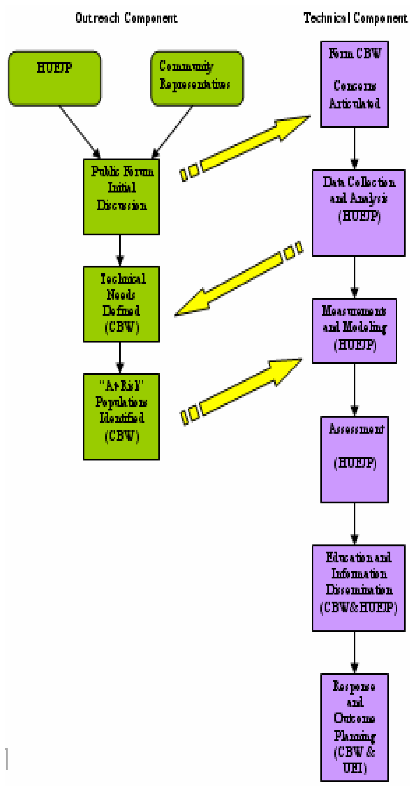
The basic approach of the HU-ATSDR (ATSDR is the Agency for Toxic and Disease Registry) partnership is to strengthen and develop linkages between: HBCUs and other minority-serving institutions, community residents, environmental health researchers, and health care providers who live and work in environmentally impacted communities through several elements. The partnership actively develops strategies for assisting individual communities in identifying the needs of its “at-risk” populations. It has also developed a comprehensive plan for working with the community to address the problems and issues concerning policies, regulations, and procedures related to the environmental characterization and assessment, cleanup, and reuse of contaminated sites and properties. The first step is the organization of public forums in order to identify and prioritize community environmental health concerns. The central mechanism for this is the formation and development of community-based working groups (CBWs) that will ultimately resolve the community’s desires and needs. A unique feature of these CBWs is the environmental health leadership training for community residents and health care providers around the identified hazards. The community’s active participation in the development and implementation of this project is vital to the project’s success and this partnership seeks to involve the community in a significant way in all possible aspects. All collaborators recognize the importance of community guidance and support in these efforts. The CBWs will assist in the development of interventions for health care providers on adverse health effects related to environmental exposures. Members of the HU-ATSDR partnership technical team will perform statistical analysis of existing health data in order to characterize risks and to identify health data gaps. Multidisciplinary teams then conduct mini-campaigns to collect in-situ measurements and perform model-based assessments of the sources of environmental exposures. The field efforts include in-situ measurements, environmental sampling, and laboratory analysis. We believe that this project can serve as a new paradigm for the development of community-university partnership programs that address environmental hazards in minority and underserved communities nationwide.
Overview of Defense Depot of Memphis, Tennessee
From January 26, 1942 until September 30, 1989, the Department of Defense operated the Defense Distribution Depot, Memphis, Tennessee (hereafter refereed to as the “DDMT”). During the operation of the DDMT, Dunn Field, a 64-acre parcel, was used for hazardous waste disposal. The site was placed on the National Priority List and became a Superfund site in October 1992 because of groundwater contamination. The types of hazardous wastes maintained and/or destroyed at the site include chemical warfare materials consisting of several thousand pounds of mustard-filled German bombs, chemical Agent Identification Kits (CAIK) consisting of glass ampoules of mustard and lewisite (a blistering chemical agent), chloroform, chloropicrin 50%, concentrated phosgene, impregnite, and decontaminating agents made up of organic N-chloroamide and 1.1.2.2-tetrachloroethane [
2]. Additionally, organic chlorinating agents (N-chloroamide and 1,3,-dichloroo-5,5-dimethlyhydantoin) were buried with food stocks, paints, acids, herbicides, volatile organic solvents, and medical waste [
2]. Historic documentation and aerial photographs have been used to determine where the actual disposal sites might be located as neither the Department of Defense nor the responsible contractors reportedly know all of the burial locations [
2,
3].
The community living adjacent to Dunn Field has consistently voiced concerns regarding the possible migration of contaminants from both on-site and off-site burial locations via surface and subsurface routes. There is widespread anecdotal evidence of numerous cancers, deaths, birth defects, and miscarriages in their community that they believe are related to the possible exposures to DDMT contaminants or their byproducts. There is a significant amount of anxiety related to the fears of the community and their lack of direct participation in the remediation and evacuation plans for the DDMT. The community has requested testing of the drainage ditches and residential yards, but their requests have been regarded as unwarranted, even though the exposure assessment of the site was based on historical records, not on actual testing of soil, water, and air. Community members further fear that each time the soil on the DDMT is disrupted, especially in Dunn Field, their neighbors will become sick or die.
The DDMT Concerned Citizens Committee has defined the impacted community as being bound by Hernando Street on the West, Pendleton and Ketchum Streets on the East, Kerr Street on the North, and Interstate 240 and Clementine Street on the South.
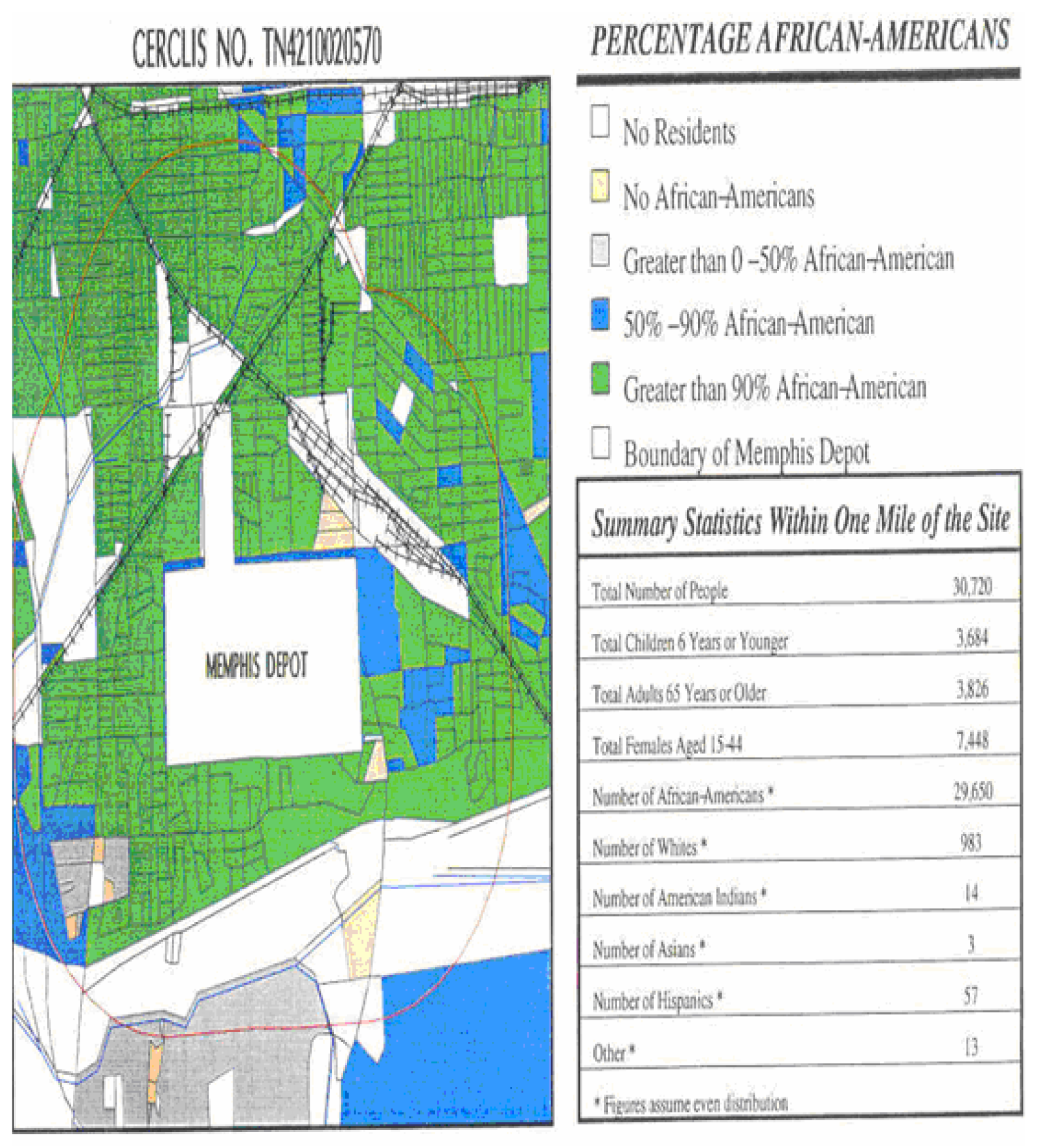
Figure 2 shows a representation of the demographics of the DDMT residential neighborhoods. According to 1990 US Census data, the zip code adjacent to the DDMT (38106) has approximately 40, 352 residents. Ninety-eight (98) percent of this population is Black. Fifty-three (53) percent of this zip code’s households have incomes less than $15,000. The 1989 median household income was $13,713. Thirty-seven (37) percent of the housing structures were built before 1949, and seventy (70) percent of the housing was built before 1969 [
4].
Based on the understanding that the residential neighborhoods adjacent to the Memphis Depot had experienced toxic exposures that have resulted in residential contamination and possible adverse health impacts, our objectives were to:
Characterize the background levels of contaminants in soil and water in the adjacent community,
Characterize community exposure levels of soil and water toxics, and
Assess the anecdotal record of mortality and morbidity associated with the DDMT.
Research of Methodology
The air, soil, and water quality data were collected according to EPA standards and compared to control communities outside of the Mississippi Delta region [
5]. Previous sampling for risk and exposure assessment served as a secondary basis for the sampling plan. However, the primary factors determining the sampling sites were community concerns and the clear identification of access points for transfer of toxics from the DDMT directly into the adjacent community. Previous sampling and testing at the DDMT are characterized by two principal shortcomings – (1) the concerns of the community were not directly addressed to the satisfaction of the residents and (2) there were no significant off-site testing to establish a baseline for the concentrations of any contaminants.
The US Army contracted Lockheed-Martin in 1985 to perform a risk assessment for the communities surrounding the DDMT [
2]. A formidable amount of work was performed, but the primary concerns of the community were not addressed. No matter how comprehensive a risk assessment is, it will not address the sustained and cumulative exposures over two generations of residents.
Another issue regarding the previous investigations of contamination from the DDMT is the lack of a refined search for byproducts and breakdown products of the chemical stockpile. Lockheed-Martin generically lists several classes of contaminants screened including pesticides, metals, and volatile organic compounds (VOCs). Since the chemical inventory of the DDMT is known, a more refined search is in order. For example, lewisite was one of the chemical warfare agents stored in the DDMT. If one were looking for evidence of lewisite migration and contamination, a search for enhanced arsenic levels in both elemental and molecular forms would be in order [
6]. The specific target compounds would be a function of soil-type and acidity. Additionally, chlorinated organic compounds and enhanced liberation of chlorine from soil-gas experiments might serve as a more useful tracer than generic tests for “pesticides, metals, and volatile organic compounds (VOCs)” [
7].
It has been shown in the recent literature that an effective tracer of warfare agents is the presence of organo-phosphorus esters and acids [
8]. These species tend to have low vapor pressures and would not be highly susceptible to detection by methods designed for volatile organic compounds.
The HUEJP work plan was designed with the purpose of estimating community exposure levels in order to assess the possibility of significant contamination of off-site locations in the residential communities adjacent to the DDMT. The work plan is composed of four basic components, the Assessment Phase, the Determination Phase, the Quantification and Analysis Phase, and the Evaluation and Response Phase. This paper summarizes the results of the second and third phases listed above.
Discussion of Sampling Plan
Environmental samples were collected, preserved, and analyzed using procedures either specifically detailed in or designed to be consistent with the Environmental Investigations Standard Procedures and Quality Assurance, 1996 (EISOPQA) Manual [
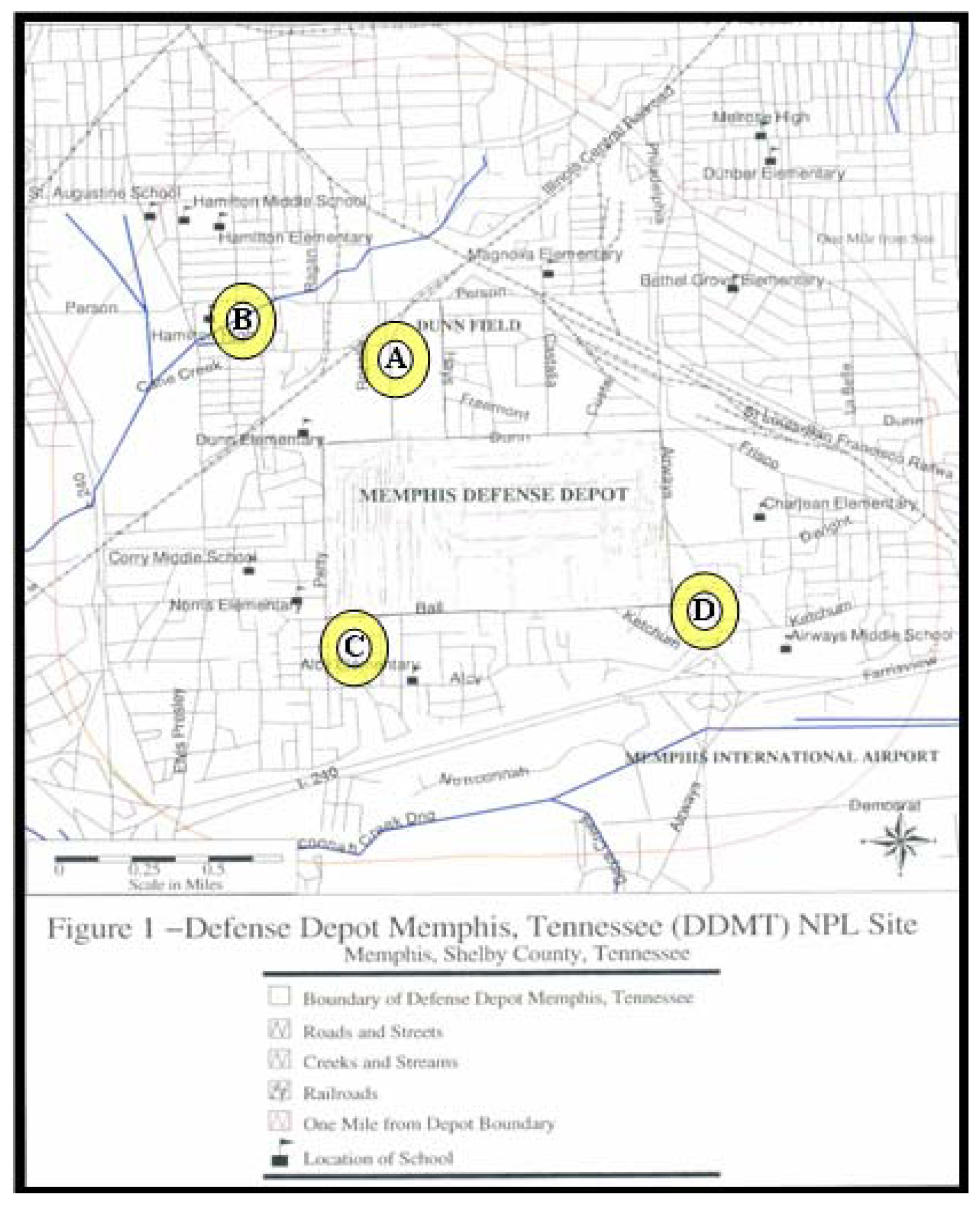
5]. All sample types were screened for heavy metals (without speciation) including cadmium, chromium, lead, arsenic, and mercury; total organic carbon; and several inorganic anions (sulfate, chloride, fluoride, phosphate, nitrite, and nitrate). The samples were collected from four separate sites near the DDMT. Each site was chosen based on its mutual proximity to the DDMT and the adjacent residential area as well as the anecdotal record of cancers, deaths, or illnesses. The sites are indicated on the map in
figures 3A–3D. Three individual samples were collected at each location. The locations are described below:
1835 Rozelle Neighborhood: Soil samples were collected from a backyard where anecdotal records had indicated off-site burial (and subsequent removal) of chemical waste from the DDMT. Soil samples were collected at 3- and 8-inch depths.
Cane Creek High School: Water and sediment samples were collected from an open drainage ditch behind and adjacent to the main school building. Both anecdotal and site records report that Cane Creek was routinely used to dispose chemicals and waste. Run-off from the DDMT is drained directly into Cane Creek. Cane Creek runs throughout the residential community and passes directly underneath the primary air-intake ducts of the high school. It was clear that even during the relatively cool spring (ambient temperatures were in the range of 45°F–55°F) the creek retains the distinct and pungent odor that the residents complain about. Water and sediment samples from Cane Creek were also collected at locations upstream and downstream of the high school by approximately one-half mile.
Corner of Ball and Mullen: Sediment and water samples were collected from an open drainage ditch extending from the western boundary of the DDMT into the adjacent community.
Storm water runoff drainage ditch: The uncovered storm water run-off is another direct access point for facile migration of contaminants from the DDMT into the community. It is located on the southern boundary of the DDMT site map (
Figure 3). Sediment and water samples were collected at this site.
We note that while the Cane Creek samples were collected from a non-stationary point source (flowing water) that rarely dries completely it is useful to compare aqueous samples to those of sediment and soil from the vicinity of the Cane Creek – Hamilton High School. While there have been no recent reports of dumping from the DDMT into Cane Creek an evaluation of its current state still gives an indication of the environmental state of this exposed transport pathway. Cane Creek has historically been and continues to be a venue for recreational activities for children and adults residing in the neighborhoods surrounding the DDMT. A comparison of the nearby soils and sediments from drainage ditches may give an indication of the retention of environmental contaminants and the extent of its transport into the community. One would expect that the sediments in the drainage ditches might be more concentrated sources of contaminants since the water in these areas tend to stand rather than flow continuously.
Results and Analysis
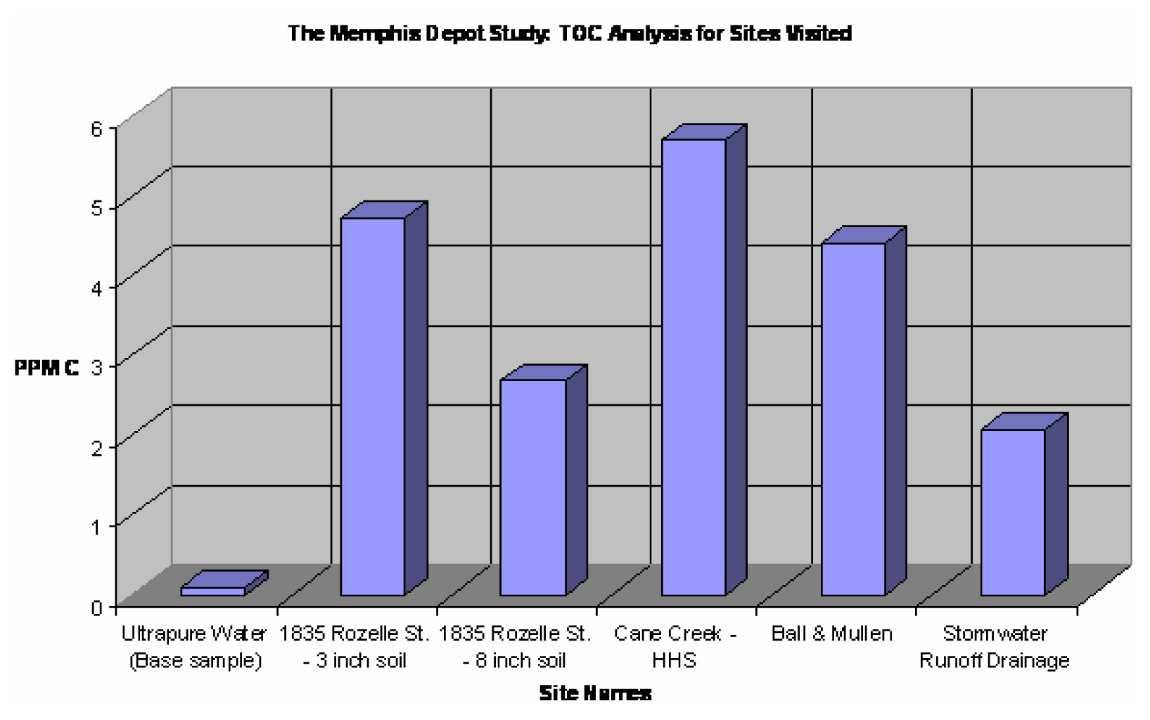
The basic objectives were to examine the water, soil, and sediment samples for evidence of cadmium, chromium, lead, arsenic, mercury, organic carbon (including polyaromatic hydrocarbons), selected herbicides, insecticides, and chemical warfare agents (e.g. soman, sarin, sulfur mustard, nitrogen mustard), and other chemicals that ranked high on the DDMT inventory. Our organic analysis focused on water-soluble total organic carbon (TOC) because of the greater potential risk of exposure to these types of compounds due to their ability to be transported via hydrological pathways.
Figure 4 shows the results of the total organic carbon analysis averaged over all of the samples at each location. A Phoenix 8000 TOC analyzer was used to estimate the total organic loading in each environmental sample. Soil samples were aspirated slowly to collect the water-soluble fraction of organics. The presence of organics in the aqueous extracts was first screened using UV-Visible spectroscopy. The aqueous extracts were then analyzed for TOC. Our results indicate a sharp gradient in concentration with depth in the soil. The Cane Creek samples exhibited the expected uniformity in values of TOC and are represented on the graph as a single data point. Although the Cane Creek samples had more TOC than the drainage ditches, none of the samples contained more than 10 ppm TOC.
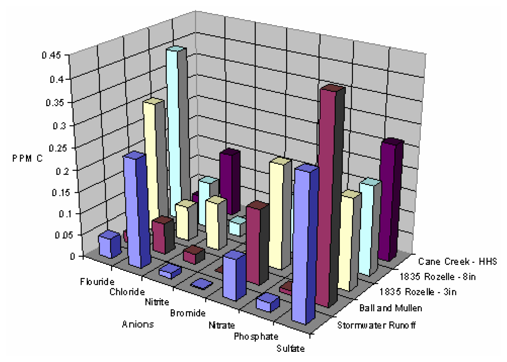
A summary of the ion chromatography results is represented in
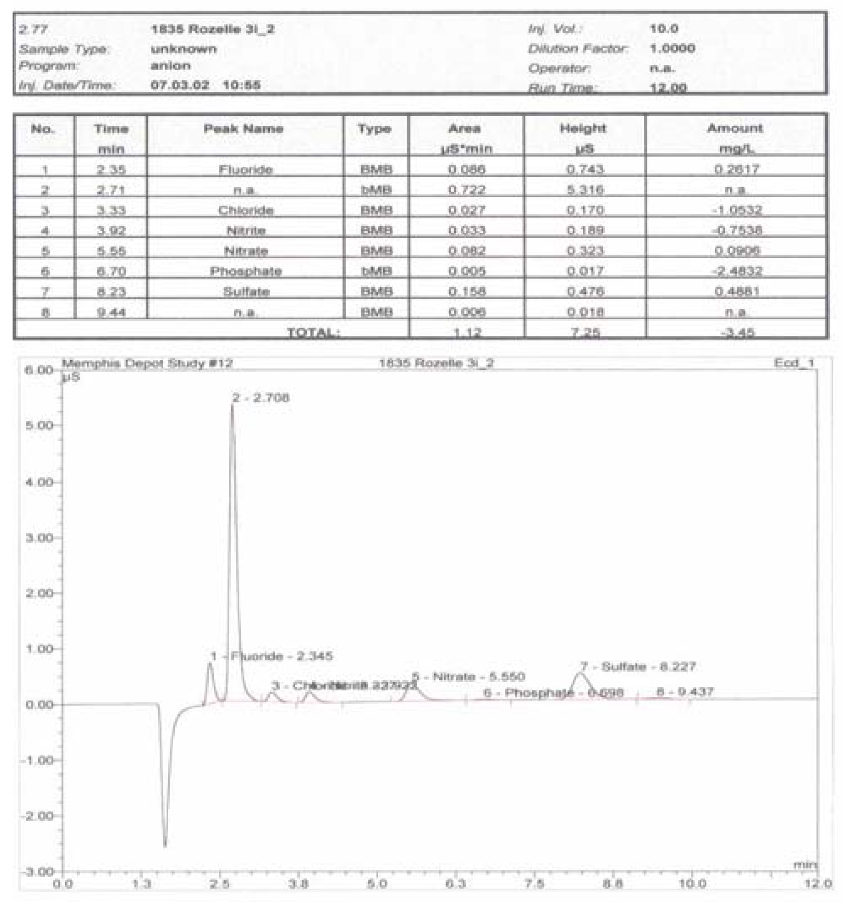
Figure 5. Once again, the aqueous samples from Cane Creek exhibit uniformity across all locations. There is considerable variability observed in the anion concentrations from site to site. Despite this, no single site possessed concentrations of any of the tested species that were higher than the EPA standards. An undetermined anion was observed in samples from all locations. The concentration of this species was observed to be the greatest in the Cane Creek and Ball and Mullin samples. The retention time for the unknown was consistent enough for it to be identified as the same species in all samples. A sample IC spectrum showing the unknown anion peak is presented in
Figure 6.
All samples were tested for a full suite of heavy metals using atomic absorption spectroscopy. Lead, arsenic, cadmium and chromium were the heavy metals identified in at least one set of samples. The full results of the atomic absorption analysis are listed in
Table 1.
Lead and chromium were observed at all sites except for Rozelle Street. Since the observed concentrations were very low and because Rozelle Street was the only site without a source of running water we feel that the most likely source of lead is the lead piping used in the water distribution system. Of the heavy metals observed consistently in the environmental samples, only chromium exceeded EPA standards. Surprisingly, the average concentration of chromium observed in the Cane Creek, Ball and Mullen, and Stormwater runoff was 126 ppm, tripling the EPA limit of 40 ppm. Identification was not attempted based on the limitations of our sampling methods. Additionally, the speciation of the chromium is a critical factor in determining both its environmental toxicity and clear source receptor relationships. Since our current methods of analysis do not permit the identification of the oxidation states of the heavy metals, our observations are limited to the identification of total environmental chromium. We note that previous engineering reports on the DDMT do not provide significant insights as to the possible sources of environmental chromium. The excessive concentrations of chromium are noteworthy because of the well-documented associations between environmental chromium and cancer incidences. Cane Creek is also by far the most accessible exposure pathway as it is largely uncovered, flows throughout the entire community and is easily available for children and domesticated animals. It is noteworthy to add that adolescent cancer incidences in the DDMT vicinity are higher than the national average and community anecdotal records report significant incidences of cancers in pets.
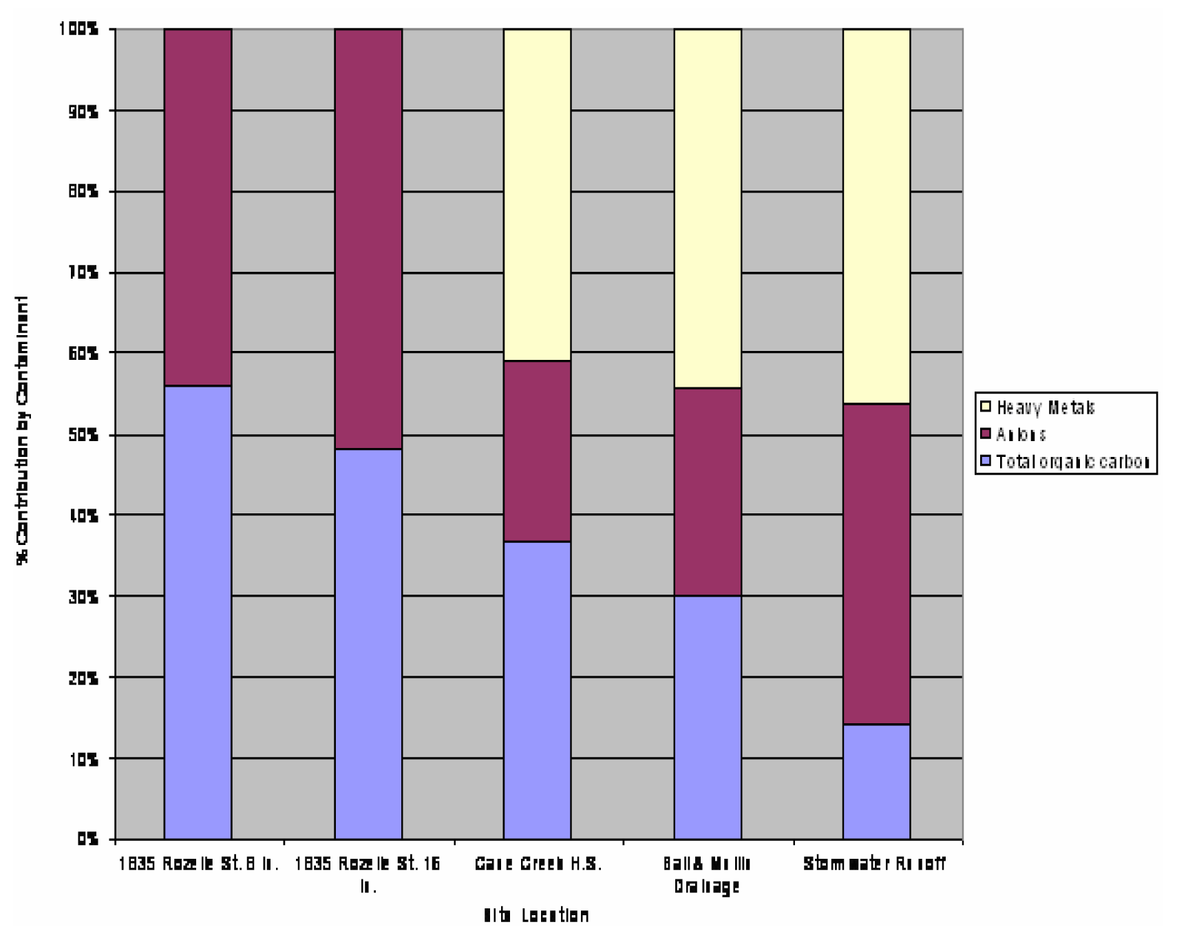
A total constituent/contaminant index was derived to summarize the results of the field measurements. The contaminant index was derived by weighing each of the contributions of organics, anions, and heavy metals based equally and then scaling the value of each contaminant observed at each site location by the total amount of each type of contaminant observed. The result of this is presented in
Figure 7. While not quantitative, this chart serves to provide a qualitative comparison of contamination at the various sites. From this chart it becomes clear that heavy metal contamination was pervasive at the sites where there was either running or standing water.
Summary
Significant amounts of organic compounds, unidentified anions, and heavy metals (Cr and Cd) have been detected in samples from the Cane Creek – HHS and Ball & Mullen sites, with a close runner-up at the 1835 Rozelle Street – 8-inch soil sample site. The highest concentrations of ions were found in the sites closest to the DDMT. The IC results showed that there was an unidentified anion detected in high quantities for all sites, with Cane Creek and Ball & Mullen ranking the highest.
The specific heavy metals detected were lead, arsenic, cadmium, and chromium. Both lead and chromium were found at all sites, except the soil sample sites at 1835 Rozelle Street. The detected value for chromium far exceeded the EPA standard limit by 86 ppm. The observed levels of cadmium in the Stormwater Runoff area were also significant (more than 65% of the EPA limit). This site represents a direct pathway for toxicant flow into the community and other similar locations may have had higher concentrations of this toxicant in the past. The results of this study indicate that there has been some presence of contamination with the marked appearance of heavy metals, an unidentified anion, and organic materials. This should provide clear justification for further sampling and detailed analysis of environmental contamination of the adjacent neighborhoods.


