Exploring the Relevance of Green Space and Epidemic Diseases Based on Panel Data in China from 2007 to 2016


Abstract
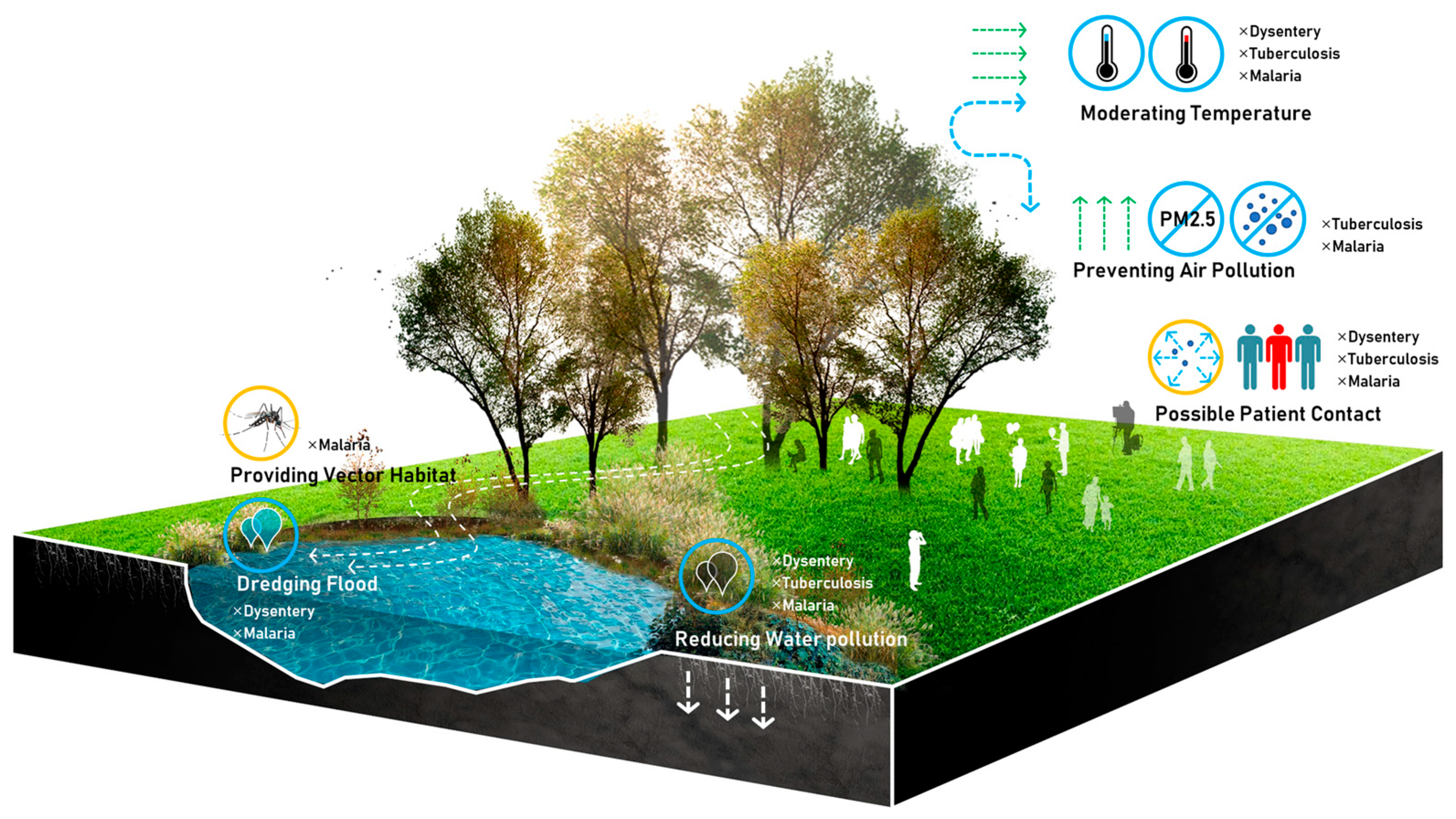
:1. Introduction
2. Materials and Methods
2.1. Variables and Data Source
2.2. Methods
3. Results
3.1. General Description of Green Space and Diseases
3.2. Spatial Distribution of Green Space and Diseases
3.3. Correlation Test and Panel Data Analysis
4. Discussion
5. Conclusions
Author Contributions
Funding
Conflicts of Interest
References
- Oswin, N. Planetary urbanization: A view from outside. Environ. Plan. D Soc. Space 2018, 36, 540–546. [Google Scholar] [CrossRef]
- Shanahan, D.F.; Lin, B.B.; Bush, R.; Gaston, K.J.; Dean, J.H.; Barber, E.; Fuller, R.A. Toward improved public health outcomes from urban nature. Am. J. Public Health 2015, 105, 470–477. [Google Scholar] [CrossRef] [PubMed]
- Vos, T.; Allen, C.; Arora, M.; Barber, R.; Bhutta, Z.; Brown, A.; Carter, A.; Casey, D.; Charlson, F.; Chen, A.; et al. Global, Regional, and National Incidence, Prevalence, and Years Lived with Disability for 310 Diseases and Injuries, 1990–2015: A Systematic Analysis for the Global Burden of Disease Study 2015; Elsevier: Amsterdam, The Netherlands, 2016; Volume 388, pp. 1545–1602. [Google Scholar]
- Sugiyama, T.; Villanueva, K.; Knuiman, M.; Francis, J.; Foster, S.; Wood, L.; Giles-Corti, B. Can neighborhood green space mitigate health inequalities? A study of socio-economic status and mental health. Health Place 2016, 38, 16–21. [Google Scholar] [CrossRef] [PubMed]
- Cohen-Cline, H.; Turkheimer, E.; Duncan, G.E. Access to green space, physical activity and mental health: A twin study. J. Epidemiol. Community Health 2015, 69, 523–529. [Google Scholar] [CrossRef] [PubMed]
- Beyer, K.M.; Kaltenbach, A.; Szabo, A.; Bogar, S.; Nieto, F.J.; Malecki, K.M. Exposure to neighborhood green space and mental health: Evidence from the survey of the health of Wisconsin. Int. J. Environ. Res. Public Health 2014, 11, 3453–3472. [Google Scholar] [CrossRef] [PubMed]
- Astell-Burt, T.; Mitchell, R.; Hartig, T. The association between green space and mental health varies across the lifecourse. A longitudinal study. J. Epidemiol. Community Health 2014, 68, 578–583. [Google Scholar] [CrossRef]
- Cariñanos, P.; Casares-Porcel, M.; Quesada-Rubio, J.M. Estimating the allergenic potential of urban green spaces: A case-study in Granada, Spain. Landsc. Urban Plan. 2014, 123, 134–144. [Google Scholar] [CrossRef]
- Hanski, I.; von Hertzen, L.; Fyhrquist, N.; Koskinen, K.; Torppa, K.; Laatikainen, T.; Karisola, P.; Auvinen, P.; Paulin, L.; Mäkelä, M.J. Environmental biodiversity, human microbiota, and allergy are interrelated. Proc. Natl. Acad. Sci. USA 2012, 109, 8334–8339. [Google Scholar] [CrossRef] [Green Version]
- Lovasi, G.S.; Quinn, J.W.; Neckerman, K.M.; Perzanowski, M.S.; Rundle, A. Children living in areas with more street trees have lower prevalence of asthma. J. Epidemiol. Community Health 2008, 62, 647–649. [Google Scholar] [CrossRef] [Green Version]
- Stigsdotter, U.K.; Ekholm, O.; Schipperijn, J.; Toftager, M.; Kamper-Jørgensen, F.; Randrup, T.B. Health promoting outdoor environments-Associations between green space, and health, health-related quality of life and stress based on a Danish national representative survey. Scand. J. Public Health 2010, 38, 411–417. [Google Scholar] [CrossRef]
- Keniger, L.E.; Gaston, K.J.; Irvine, K.N.; Fuller, R.A. What are the benefits of interacting with nature? Int. J. Environ. Res. Public Health 2013, 10, 913–935. [Google Scholar] [CrossRef] [PubMed]
- Berman, M.G.; Jonides, J.; Kaplan, S. The cognitive benefits of interacting with nature. Psychol. Sci. 2008, 19, 1207–1212. [Google Scholar] [CrossRef] [PubMed]
- Flowers, E.P.; Freeman, P.; Gladwell, V.F. A cross-sectional study examining predictors of visit frequency to local green space and the impact this has on physical activity levels. BMC Public Health 2016, 16, 420. [Google Scholar] [CrossRef] [PubMed]
- Hunter, R.F.; Christian, H.; Veitch, J.; Astell-Burt, T.; Hipp, J.A.; Schipperijn, J. The impact of interventions to promote physical activity in urban green space: A systematic review and recommendations for future research. Soc. Sci. Med. 2015, 124, 246–256. [Google Scholar] [CrossRef] [Green Version]
- Mitchell, R. Is physical activity in natural environments better for mental health than physical activity in other environments? Soc. Sci. Med. 2013, 91, 130–134. [Google Scholar] [CrossRef]
- Shinew, K.J.; Glover, T.D.; Parry, D.C. Leisure spaces as potential sites for interracial interaction: Community gardens in urban areas. J. Leis. Res. 2004, 36, 336–355. [Google Scholar] [CrossRef]
- Dannenberg, A.L.; Jackson, R.J.; Frumkin, H.; Schieber, R.A.; Pratt, M.; Kochtitzky, C.; Tilson, H.H. The impact of community design and land-use choices on public health: A scientific research agenda. Am. J. Public Health 2003, 93, 1500–1508. [Google Scholar] [CrossRef]
- Zhang, H.; Si, Y.; Wang, X.; Gong, P. Patterns of Bacillary Dysentery in China, 2005–2010. Int. J. Environ. Res. Public Health 2016, 13, 164. [Google Scholar] [CrossRef]
- Roth, D.; Otterstatter, M.; Wong, J.; Cook, V.; Johnston, J.; Mak, S. Identification of spatial and cohort clustering of tuberculosis using surveillance data from British Columbia, Canada, 1990–2013. Soc. Sci. Med. 2016, 168, 214–222. [Google Scholar] [CrossRef]
- Ngom, R.; Siegmund, A. The key role of socio-demographic and socio-environmental factors in urban malaria occurrence and control—An illustration using the city of Yaoundé. Soc. Sci. Med. 2015, 133, 269–279. [Google Scholar] [CrossRef]
- Ma, Y.; Zhang, T.; Liu, L.; Lv, Q.; Yin, F. Spatio-Temporal Pattern and Socio-Economic Factors of Bacillary Dysentery at County Level in Sichuan Province, China. Sci. Rep. 2015, 5, 15264. [Google Scholar] [CrossRef] [PubMed] [Green Version]
- Ruktanonchai, N.W.; Deleenheer, P.; Tatem, A.J.; Alegana, V.A.; Caughlin, T.T.; Zu, E.S.E.; Lourenço, C.; Ruktanonchai, C.W.; Smith, D.L. Identifying Malaria Transmission Foci for Elimination Using Human Mobility Data. PLoS Comput. Biol. 2016, 12, e1004846. [Google Scholar] [CrossRef] [PubMed]
- Rosas-Aguirre, A.; Guzman-Guzman, M.; Gamboa, D.; Chuquiyauri, R.; Ramirez, R.; Manrique, P.; Carrasco-Escobar, G.; Puemape, C.; Llanos-Cuentas, A.; Vinetz, J.M. Micro-heterogeneity of malaria transmission in the Peruvian Amazon: A baseline assessment underlying a population-based cohort study. Malar. J. 2017, 16, 312. [Google Scholar] [CrossRef] [PubMed]
- Feng, J.; Tu, H.; Zhang, L.; Zhang, S.; Jiang, S.; Xia, Z.; Zhou, S. Mapping transmission foci to eliminate malaria in the People’s Republic of China, 2010–2015: A retrospective analysis. BMC Infect. Dis. 2018, 18, 115. [Google Scholar] [CrossRef] [PubMed]
- Pizzitutti, F.; Pan, W.; Feingold, B.; Zaitchik, B.; CA, Á.; Mena, C.F. Out of the net: An agent-based model to study human movements influence on local-scale malaria transmission. PLoS ONE 2018, 13, e0193493. [Google Scholar] [CrossRef] [PubMed]
- Yang, G.J.; Utzinger, J.; Zhou, X.N. Interplay between environment, agriculture and infectious diseases of poverty: Case studies in China. Acta Trop. 2015, 141, 399–406. [Google Scholar] [CrossRef] [PubMed]
- Yi, L.; Xu, X.; Ge, W.; Xue, H.; Li, J.; Li, D.; Wang, C.; Wu, H.; Liu, X.; Zheng, D.; et al. The impact of climate variability on infectious disease transmission in China: Current knowledge and further directions. Environ. Res. 2019, 173, 255–261. [Google Scholar] [CrossRef]
- Xiao, G.; Xu, C.; Wang, J.; Yang, D.; Wang, L. Spatial–temporal pattern and risk factor analysis of bacillary dysentery in the Beijing–Tianjin–Tangshan urban region of China. BMC Public Health 2014, 14, 998. [Google Scholar] [CrossRef]
- Ncayiyana, J.R.; Bassett, J.; West, N.; Westreich, D.; Musenge, E.; Emch, M.; Pettifor, A.; Hanrahan, C.F.; Schwartz, S.R.; Sanne, I. Prevalence of latent tuberculosis infection and predictive factors in an urban informal settlement in Johannesburg, South Africa: A cross-sectional study. BMC Infect. Dis. 2016, 16, 661. [Google Scholar] [CrossRef]
- Alene, K.A.; Viney, K.; Mcbryde, E.S.; Clements, A.C. Spatial patterns of multidrug resistant tuberculosis and relationships to socio-economic, demographic and household factors in northwest Ethiopia. PLoS ONE 2017, 12, e0171800. [Google Scholar] [CrossRef]
- Sotgiu, G.; Dara, M.; Centis, R.; Matteelli, A.; Solovic, I.; Gratziou, C.; Rendon, A.; Migliori, G.B. Breaking the barriers: Migrants and tuberculosis. Presse Med. 2017, 46, e5–e11. [Google Scholar] [CrossRef] [PubMed]
- Ge, E.; Zhang, X.; Wang, X.; Wei, X. Spatial and temporal analysis of tuberculosis in Zhejiang Province, China, 2009–2012. Infect. Dis. Poverty 2016, 5, 11. [Google Scholar] [CrossRef]
- Abdul Rasam, A.R.; Mohd Shariff, N.; Dony, J.F. Geospatial-Based Model for Diagnosing Potential High-Risk Areas of Tuberculosis Disease in Malaysia. MATEC Web Conf. 2019, 266, 02007. [Google Scholar] [CrossRef]
- Ge, E.; Lai, P.-C.; Zhang, X.; Yang, X.; Li, X.; Wang, H.; Wei, X. Regional transport and its association with tuberculosis in the Shandong province of China, 2009–2011. J. Transport. Geogr. 2015, 46, 232–243. [Google Scholar] [CrossRef]
- De Silva, P.M.; Marshall, J.M. Factors contributing to urban malaria transmission in sub-saharan Africa: A systematic review. J. Trop. Med. 2012, 2012, 819563. [Google Scholar] [CrossRef] [PubMed]
- Lana, R.M.; Riback, T.I.S.; Lima, T.F.M. Socioeconomic and demographic characterization of an endemic malaria region in brazil by multiple correspondence analysis. Malaria J. 2017, 16, 397. [Google Scholar] [CrossRef] [PubMed]
- Tusting, L.S.; Willey, B.; Lines, J. Building malaria out: Improving health in the home. Malar. J. 2016, 15, 320. [Google Scholar] [CrossRef] [PubMed]
- Nadi, A.; Abedi, G.; Isazadeh, K.; Rostami, F.; Siamian, H.; Hosseini, M.; Asadialiabadi, M. Epidemiologic Investigation of Dysentery in North of Iran: Use of Geographic Information System (GIS). Mater. Socio-Med. 2016, 28, 444–448. [Google Scholar] [CrossRef] [Green Version]
- Zhang, H.; Si, Y.; Wang, X.; Gong, P. Environmental Drivers and Predicted Risk of Bacillary Dysentery in Southwest China. Int. J. Environ. Res. Public Health 2017, 14, 782. [Google Scholar] [CrossRef] [PubMed]
- Zhang, F.; Ding, G.; Liu, Z.; Zhang, C.; Jiang, B. Association between flood and the morbidity of bacillary dysentery in Zibo City, China: A symmetric bidirectional case-crossover study. Int. J. Biometeorol. 2016, 60, 1919–1924. [Google Scholar] [CrossRef]
- Liu, X.; Liu, Z.; Ding, G.; Jiang, B. Projected burden of disease for bacillary dysentery due to flood events in Guangxi, China. Sci. Total Environ. 2017, 601–602, 1298–1305. [Google Scholar] [CrossRef] [PubMed]
- Xu, C.; Li, Y.; Wang, J.; Xiao, G. Spatial-temporal detection of risk factors for bacillary dysentery in Beijing, Tianjin and Hebei, China. BMC Public Health 2017, 17, 743. [Google Scholar] [CrossRef] [PubMed]
- Li, K.; Zhao, K.; Shi, L.; Wen, L.; Yang, H.; Cheng, J.; Wang, X.; Su, H. Daily temperature change in relation to the risk of childhood bacillary dysentery among different age groups and sexes in a temperate city in China. Public Health 2016, 131, 20–26. [Google Scholar] [CrossRef] [PubMed]
- Wen, L.Y.; Zhao, K.F.; Cheng, J.; Wang, X.; Yang, H.H.; Li, K.S.; Xu, Z.W.; Su, H. The association between diurnal temperature range and childhood bacillary dysentery. Int. J. Biometeorol. 2016, 60, 269–276. [Google Scholar] [CrossRef] [PubMed]
- Cheng, J.; Xie, M.Y.; Zhao, K.F.; Wu, J.J.; Xu, Z.W.; Song, J.; Zhao, D.S.; Li, K.S.; Wang, X.; Yang, H.H. Impacts of ambient temperature on the burden of bacillary dysentery in urban and rural Hefei, China. Epidemiol. Infect. 2017, 145, 1567–1576. [Google Scholar] [CrossRef] [PubMed] [Green Version]
- Li, R.; Richmond, P.; Roehner, B.M. Effect of population density on epidemics. Phys. A Stat. Mech. Appl. 2018, 510, 713–724. [Google Scholar] [CrossRef] [Green Version]
- Dowdy, D.W.; Azman, A.S.; Kendall, E.A.; Mathema, B. Transforming the Fight Against Tuberculosis: Targeting Catalysts of Transmission. Clin. Infect. Dis. 2014, 59, 1123–1129. [Google Scholar] [CrossRef] [Green Version]
- Churchyard, G.; Kim, P.; Shah, N.S.; Rustomjee, R.; Gandhi, N.; Mathema, B.; Dowdy, D.; Kasmar, A.; Cardenas, V. What We Know About Tuberculosis Transmission: An Overview. J. Infect. Dis. 2017, 216, S629. [Google Scholar] [CrossRef]
- Oren, E. The global health threat of African urban slums: The example of urban tuberculosis. Afr. Geogr. Rev. 2015, 34, 182–195. [Google Scholar]
- Mollalo, A.; Mao, L.; Rashidi, P.; Glass, G.E. A GIS-Based Artificial Neural Network Model for Spatial Distribution of Tuberculosis across the Continental United States. Int. J. Environ. Res. Public Health 2019, 16, 157. [Google Scholar] [CrossRef]
- Dal’Asta, A.P.; Lana, R.M.; Amaral, S.; Codeço, C.T.; Monteiro, A.M.V. The Urban Gradient in Malaria-Endemic Municipalities in Acre: Revisiting the Role of Locality. Int. J. Environ. Res. Public Health 2018, 15, 1254. [Google Scholar] [CrossRef] [PubMed]
- Castro, M.C. Malaria Transmission and Prospects for Malaria Eradication: The Role of the Environment. Cold Spring Harb. Perspect. Med. 2017, 7, a025601. [Google Scholar] [CrossRef] [PubMed] [Green Version]
- Yamana, T.K.; Eltahir, E.A.B. Projected impacts of climate change on environmental suitability for malaria transmission in West Africa. Environ. Health Perspect. 2013, 121, 1179–1186. [Google Scholar] [CrossRef] [PubMed]
- Stone, C.M.; Witt, A.B.R.; Walsh, G.C.; Foster, W.A.; Murphy, S.T. Would the control of invasive alien plants reduce malaria transmission? A review. Parasites Vectors 2018, 11, 76. [Google Scholar] [CrossRef] [PubMed]
- Sadoine, M.L.; Smargiassi, A.; Ridde, V.; Tusting, L.S.; Zinszer, K. The associations between malaria, interventions, and the environment: A systematic review and meta-analysis. Malar. J. 2018, 17, 73. [Google Scholar] [CrossRef] [PubMed]
- Paul, P.; Kangalawe, R.Y.M.; Mboera, L.E.G. Land-use patterns and their implication on malaria transmission in Kilosa District, Tanzania. Trop. Dis. Travel Med. Vaccines 2018, 4, 6. [Google Scholar] [CrossRef] [PubMed]
- Gatton, M. Environmental factors and malaria transmission risk. Lancet Infect. Dis. 2010, 10, 15–16. [Google Scholar] [CrossRef]
- Murdock, C.C.; Sternberg, E.D.; Thomas, M.B. Malaria transmission potential could be reduced with current and future climate change. Sci. Rep. 2016, 6, 27771. [Google Scholar] [CrossRef] [Green Version]
- Hundessa, S.; Li, S.; Liu, D.L.; Guo, J.; Guo, Y.; Zhang, W.; Williams, G. Projecting environmental suitable areas for malaria transmission in China under climate change scenarios. Environ. Res. 2018, 162, 203–210. [Google Scholar] [CrossRef]
- Amadi, J.A.; Olago, D.O.; Ong’Amo, G.O.; Oriaso, S.O.; Nanyingi, M.; Nyamongo, I.K.; Bba, E. Sensitivity of vegetation to climate variability and its implications for malaria risk in Baringo, Kenya. PLoS ONE 2018, 13, e0199357. [Google Scholar] [CrossRef]
- Merkord, C.L.; Davis, J.K.; Wimberly, M.C. Evaluation of environmentally driven models for early warning of malaria: An exploratory study. Lancet 2017, 389, S13. [Google Scholar] [CrossRef]
- Chen, Q.; Mei, K.; Dahlgren, R.A.; Wang, T.; Gong, J.; Zhang, M. Impacts of land use and population density on seasonal surface water quality using a modified geographically weighted regression. Sci. Total Environ. 2016, 572, 450–466. [Google Scholar] [CrossRef] [PubMed] [Green Version]
- Meerow, S.; Newell, J.P. Spatial planning for multifunctional green infrastructure: Growing resilience in Detroit. Landsc. Urban Plan. 2017, 159, 62–75. [Google Scholar] [CrossRef]
- Livesley, S.J.; McPherson, E.G.; Calfapietra, C. The Urban Forest and Ecosystem Services: Impacts on Urban Water, Heat, and Pollution Cycles at the Tree, Street, and City Scale. J. Environ. Qual. 2016, 45, 119–124. [Google Scholar] [CrossRef] [PubMed]
- Asgarian, A.; Amiri, B.J.; Sakieh, Y. Assessing the effect of green cover spatial patterns on urban land surface temperature using landscape metrics approach. Urban Ecosyst. 2015, 18, 209–222. [Google Scholar] [CrossRef]
- Xia, J.; Zhang, Y.; Xiong, L.; He, S.; Wang, L.; Yu, Z. Opportunities and challenges of the Sponge City construction related to urban water issues in China. Sci. China Earth Sci. 2017, 60, 652–658. [Google Scholar] [CrossRef]
- Maas, J.; Verheij, R.A.; Groenewegen, P.P.; De Vries, S.; Spreeuwenberg, P. Green space, urbanity, and health: How strong is the relation? J. Epidemiol. Community Health 2006, 60, 587–592. [Google Scholar] [CrossRef] [PubMed]
- Van den Berg, A.E.; Maas, J.; Verheij, R.A.; Groenewegen, P.P. Green space as a buffer between stressful life events and health. Soc. Sci. Med. 2010, 70, 1203–1210. [Google Scholar] [CrossRef] [Green Version]
- Schüle, S.A.; Gabriel, K.M.A.; Bolte, G. Relationship between neighbourhood socioeconomic position and neighbourhood public green space availability: An environmental inequality analysis in a large German city applying generalized linear models. Int. J. Hyg. Environ. Health 2017, 220, 711. [Google Scholar] [CrossRef]
- You, H. Characterizing the inequalities in urban public green space provision in Shenzhen, China. Habitat Int. 2016, 56, 176–180. [Google Scholar] [CrossRef]
- Xiao, Y.; Li, Z.; Webster, C. Estimating the mediating effect of privately-supplied green space on the relationship between urban public green space and property value: Evidence from Shanghai, China. Land Use Policy 2016, 54, 439–447. [Google Scholar] [CrossRef]
- Seeland, K.; Dübendorfer, S.; Hansmann, R. Making friends in Zurich’s urban forests and parks: The role of public green space for social inclusion of youths from different cultures. For. Policy Econ. 2009, 11, 10–17. [Google Scholar] [CrossRef]
- Annerstedt van den Bosch, M.; Mudu, P.; Uscila, V.; Barrdahl, M.; Kulinkina, A.; Staatsen, B.; Swart, W.; Kruize, H.; Zurlyte, I.; Egorov, A.I. Development of an urban green space indicator and the public health rationale. Scand. J. Public Health 2016, 44, 159–167. [Google Scholar] [CrossRef] [PubMed]
- Koohsari, M.J.; Mavoa, S.; Villanueva, K.; Sugiyama, T.; Badland, H.; Kaczynski, A.T.; Owen, N.; Giles-Corti, B. Public open space, physical activity, urban design and public health: Concepts, methods and research agenda. Health Place 2015, 33, 75–82. [Google Scholar] [CrossRef] [PubMed] [Green Version]
- Koprowska, K.; Łaszkiewicz, E.; Kronenberg, J.; Marcińczak, S. Subjective perception of noise exposure in relation to urban green space availability. Urban For. Urban Green. 2018, 31, 93–102. [Google Scholar] [CrossRef]
- Wolch, J.R.; Byrne, J.; Newell, J.P. Urban green space, public health, and environmental justice: The challenge of making cities ‘just green enough’. Landsc. Urban Plan. 2014, 125, 234–244. [Google Scholar] [CrossRef]
- Sha, T.; Yan, Y.; Gao, X.; Xiang, S.; Zeng, G.; Liu, S.; He, Q. Association between Sleep and Body Weight: A Panel Data Model Based on a Retrospective Longitudinal Cohort of Chinese Infants. Int. J. Environ. Res. Public Health 2017, 14, 458. [Google Scholar]
- Marmot, M. Social determinants of health inequalities. Lancet 2012, 51, 1–4. [Google Scholar] [CrossRef]
- Levy, L.; Herzog, A.N. Effects of population density and crowding on health on health and social adapation in the Netherlands. J. Health Soc. Behav. 1974, 15, 228–240. [Google Scholar] [CrossRef]
- Cao, Q.; Liang, Y.; Niu, X. China’s Air Quality and Respiratory Disease Mortality Based on the Spatial Panel Model. Int. J. Environ. Res. Public Health 2017, 14, 1081. [Google Scholar] [CrossRef]
- Bayati, M.; Vahedi, S.; Esmaeilzadeh, F.; Kavosi, Z.; Jamali, Z.; Rajabi, A.; Alimohamadi, Y. Determinants of maternal mortality in Eastern Mediterranean region: A panel data analysis. Med. J. Islam. Repub. Iran 2016, 30, 360. [Google Scholar] [PubMed]


| 1–1 Epidemics Indices | ||||||||||
| Dysentery (Incidence per 100,000 person) | ||||||||||
| Year | 2007 | 2008 | 2009 | 2010 | 2011 | 2012 | 2013 | 2014 | 2015 | 2016 |
| Min. | 6.31 | 5.66 | 4.64 | 4.49 | 2.84 | 2.45 | 1.62 | 0.86 | 0.86 | 0.80 |
| Median | 25.20 | 22.08 | 17.75 | 18.31 | 16.31 | 14.51 | 14.03 | 10.87 | 10.87 | 9.12 |
| Mean | 40.52 | 32.93 | 28.60 | 24.67 | 22.61 | 19.52 | 17.61 | 14.44 | 14.44 | 12.99 |
| Max. | 235.42 | 152.01 | 143.01 | 132.37 | 94.45 | 65.32 | 64.52 | 51.79 | 51.79 | 52.79 |
| S.E. | 45.52 | 32.09 | 28.42 | 24.21 | 18.90 | 15.40 | 14.31 | 12.29 | 12.29 | 11.65 |
| Tuberculosis (Incidence per 100,000 person) | ||||||||||
| Year | 2007 | 2008 | 2009 | 2010 | 2011 | 2012 | 2013 | 2014 | 2015 | 2016 |
| Min. | 35.83 | 33.98 | 26.91 | 25.54 | 26.69 | 24.41 | 22.28 | 21.27 | 21.27 | 19.52 |
| Median | 88.64 | 88.11 | 82.48 | 74.07 | 69.91 | 70.52 | 62.90 | 61.84 | 61.84 | 56.66 |
| Mean | 91.84 | 91.39 | 84.41 | 77.80 | 75.23 | 75.64 | 71.11 | 70.42 | 70.42 | 68.85 |
| Max. | 199.99 | 202.93 | 186.35 | 164.46 | 157.83 | 181.17 | 172.73 | 176.00 | 176.00 | 184.53 |
| S.E. | 36.46 | 37.84 | 33.09 | 28.64 | 29.24 | 33.05 | 33.50 | 34.14 | 34.14 | 36.47 |
| Malaria (Incidence per 100,000 person) | ||||||||||
| Year | 2007 | 2008 | 2009 | 2010 | 2011 | 2012 | 2013 | 2014 | 2015 | 2016 |
| Min. | 0.00 | 0.01 | 0.00 | 0.01 | 0.02 | 0.01 | 0.03 | 0.01 | 0.01 | 0.01 |
| Median | 0.16 | 0.13 | 0.16 | 0.12 | 0.11 | 0.10 | 0.11 | 0.13 | 0.13 | 0.15 |
| Mean | 3.82 | 2.11 | 1.08 | 0.49 | 0.26 | 0.16 | 0.24 | 0.18 | 0.18 | 0.20 |
| Max. | 44.69 | 22.04 | 9.65 | 4.63 | 2.60 | 1.37 | 2.69 | 0.95 | 0.95 | 1.09 |
| S.E. | 10.72 | 5.53 | 2.38 | 0.97 | 0.48 | 0.25 | 0.48 | 0.18 | 0.18 | 0.21 |
| 1–2 Three Kinds of Green Space Indices | ||||||||||
| Green Space (Units: 100 km2) | ||||||||||
| Year | 2007 | 2008 | 2009 | 2010 | 2011 | 2012 | 2013 | 2014 | 2015 | 2016 |
| Min. | 0.20 | 0.20 | 0.22 | 0.21 | 0.29 | 0.34 | 0.36 | 0.42 | 0.53 | 0.62 |
| Median | 3.26 | 3.85 | 4.29 | 4.79 | 4.98 | 5.18 | 5.36 | 5.74 | 6.31 | 6.56 |
| Mean | 5.56 | 5.69 | 6.43 | 6.89 | 7.24 | 7.64 | 7.83 | 8.15 | 8.61 | 8.99 |
| Max. | 27.47 | 37.70 | 40.16 | 42.04 | 41.06 | 40.17 | 41.20 | 42.19 | 43.84 | 45.27 |
| S.E. | 6.26 | 7.05 | 7.60 | 7.94 | 7.87 | 7.86 | 8.19 | 8.39 | 8.64 | 8.93 |
| Public Green Space (Units: 100 km2) | ||||||||||
| Year | 2007 | 2008 | 2009 | 2010 | 2011 | 2012 | 2013 | 2014 | 2015 | 2016 |
| Min. | 0.02 | 0.03 | 0.04 | 0.03 | 0.05 | 0.05 | 0.06 | 0.07 | 0.09 | 0.09 |
| Median | 0.78 | 0.91 | 1.00 | 1.10 | 1.21 | 1.30 | 1.39 | 1.45 | 1.53 | 1.63 |
| Mean | 1.09 | 1.18 | 1.30 | 1.42 | 1.56 | 1.67 | 1.77 | 1.86 | 1.98 | 2.11 |
| Max. | 4.76 | 5.02 | 5.32 | 5.85 | 6.80 | 7.40 | 7.89 | 8.32 | 8.96 | 9.75 |
| S.E. | 1.03 | 1.07 | 1.14 | 1.23 | 1.36 | 1.46 | 1.55 | 1.63 | 1.74 | 1.88 |
| Green Space Coverage Ratio (Units: %) | ||||||||||
| Year | 2007 | 2008 | 2009 | 2010 | 2011 | 2012 | 2013 | 2014 | 2015 | 2016 |
| Min. | 24.10 | 25.10 | 27.30 | 16.00 | 24.10 | 30.00 | 18.10 | 30.80 | 29.80 | 31.10 |
| Median | 35.60 | 35.90 | 37.20 | 37.70 | 38.30 | 38.70 | 38.40 | 39.80 | 39.20 | 39.90 |
| Mean | 34.18 | 35.32 | 36.70 | 36.33 | 37.75 | 38.46 | 38.13 | 39.34 | 39.11 | 39.17 |
| Max. | 42.80 | 42.60 | 47.70 | 46.60 | 46.80 | 46.20 | 47.10 | 49.10 | 48.40 | 48.40 |
| S.E. | 4.51 | 4.54 | 4.80 | 6.03 | 4.66 | 3.83 | 5.24 | 3.76 | 3.68 | 3.67 |
| 1–3 Socioeconomic Variables | ||||||||||
| Medical Workers (Units: 10,000 People) | ||||||||||
| Year | 2007 | 2008 | 2009 | 2010 | 2011 | 2012 | 2013 | 2014 | 2015 | 2016 |
| Min. | 1.02 | 1.17 | 1.60 | 1.67 | 2.22 | 2.16 | 2.47 | 2.65 | 2.91 | 2.92 |
| Median | 17.51 | 18.35 | 22.35 | 23.09 | 24.46 | 25.96 | 26.98 | 28.28 | 29.16 | 30.17 |
| Mean | 19.06 | 19.90 | 25.10 | 26.44 | 27.76 | 29.38 | 31.55 | 32.98 | 34.46 | 36.01 |
| Max. | 45.21 | 47.98 | 60.21 | 64.59 | 68.96 | 73.89 | 81.93 | 83.85 | 85.57 | 87.41 |
| S.E. | 11.49 | 12.02 | 15.62 | 16.55 | 17.47 | 18.57 | 20.24 | 20.99 | 21.78 | 22.67 |
| Population (Units: 10,000 People) | ||||||||||
| Year | 2007 | 2008 | 2009 | 2010 | 2011 | 2012 | 2013 | 2014 | 2015 | 2016 |
| Min. | 289.0 | 292.0 | 296.0 | 300.0 | 303.0 | 308.0 | 312.0 | 318.0 | 324.0 | 331.0 |
| Median | 3708.0 | 3718.0 | 3727.0 | 3735.0 | 3743.0 | 3753.0 | 3774.0 | 3806.0 | 3812.0 | 3813.0 |
| Mean | 4206.0 | 4240.0 | 4272.0 | 4303.0 | 4324.0 | 4348.0 | 4371.0 | 4395.0 | 4422.0 | 4451.0 |
| Max. | 9660.0 | 9893.0 | 10,130.0 | 10,441.0 | 10,505.0 | 10,594.0 | 10,644.0 | 10,724.0 | 10,849.0 | 10,999.0 |
| S.E. | 2706.2 | 2725.7 | 2748.3 | 2765.0 | 2769.4 | 2778.8 | 2785.7 | 2797.8 | 2817.2 | 2843.1 |
| Urban Population (Units: 10,000 People) | ||||||||||
| Year | 2007 | 2008 | 2009 | 2010 | 2011 | 2012 | 2013 | 2014 | 2015 | 2016 |
| Min. | 62.0 | 64.0 | 66.0 | 68.0 | 69.0 | 70.0 | 74.0 | 82.0 | 90.0 | 98.0 |
| Median | 1728.0 | 1820.0 | 1904.0 | 1844.0 | 1942.0 | 2038.0 | 2115.0 | 2173.0 | 2116.0 | 2148.0 |
| Mean | 1936.0 | 2005.0 | 2068.0 | 2166.0 | 2236.0 | 2311.0 | 2371.0 | 2432.0 | 2500.0 | 2574.0 |
| Max. | 6099.0 | 6269.0 | 6423.0 | 6910.0 | 6986.0 | 7140.0 | 7212.0 | 7292.0 | 7454.0 | 7611.0 |
| S.E. | 1314.5 | 1352.7 | 1389.5 | 1479.3 | 1511.2 | 1550.6 | 1579.2 | 1608.2 | 1656.3 | 1707.7 |
| Population Density (Units: person per km2) | ||||||||||
| Year | 2007 | 2008 | 2009 | 2010 | 2011 | 2012 | 2013 | 2014 | 2015 | 2016 |
| Min. | 622.0 | 649.0 | 902.0 | 575.0 | 515.0 | 1032.0 | 1059.0 | 1291.0 | 1336.0 | 1145.0 |
| Median | 2376.0 | 2370.0 | 2344.0 | 2428.0 | 2487.0 | 2674.0 | 2570.0 | 2604.0 | 2557.0 | 2624.0 |
| Mean | 2607.0 | 2642.0 | 2634.0 | 2707.0 | 2725.0 | 2805.0 | 2818.0 | 2850.0 | 2776.0 | 2809.0 |
| Max. | 5938.0 | 5967.0 | 5530.0 | 5506.0 | 5821.0 | 5483.0 | 5541.0 | 5474.0 | 5504.0 | 5244.0 |
| S.E. | 1341.8 | 1353.3 | 1248.7 | 1343.8 | 1322.8 | 1238.1 | 1193.0 | 1184.3 | 1121.3 | 1084.2 |
| Built-Up Area (Units: km2) | ||||||||||
| Year | 2007 | 2008 | 2009 | 2010 | 2011 | 2012 | 2013 | 2014 | 2015 | 2016 |
| Min. | 79.0 | 79.0 | 81.0 | 85.0 | 90.0 | 120.0 | 120.0 | 126.0 | 145.0 | 145.0 |
| Median | 886.0 | 885.0 | 950.0 | 1038.0 | 1077.0 | 1133.0 | 1206.0 | 1231.0 | 1329.0 | 1371.0 |
| Mean | 1144.2 | 1199.8 | 1259.9 | 1334.1 | 1406.6 | 1470.0 | 1543.6 | 1605.5 | 1681.0 | 1753.0 |
| Max. | 4084.0 | 4133.0 | 4434.0 | 4618.0 | 4829.0 | 5026.0 | 5232.0 | 5398.0 | 5633.0 | 5808.0 |
| S.E. | 882.5 | 882.5 | 962.3 | 1011.8 | 1058.9 | 1100.8 | 1147.1 | 1193.4 | 1238.9 | 1289.6 |
| GDP (Units: 100 Million RMB) | ||||||||||
| Year | 2007 | 2008 | 2009 | 2010 | 2011 | 2012 | 2013 | 2014 | 2015 | 2016 |
| Min. | 341.4 | 394.9 | 441.4 | 507.5 | 605.8 | 701.0 | 815.7 | 920.8 | 1026.0 | 1151.0 |
| Median | 6423.2 | 8314.4 | 8587.0 | 10,368.6 | 12,582.0 | 14,454.0 | 16,205.5 | 17,689.9 | 17,832.0 | 18,499.0 |
| Mean | 9023.8 | 10,752.1 | 11,784.0 | 14,098.1 | 16,820.7 | 18,598.0 | 20,462.8 | 22,075.8 | 23,315.0 | 25,164.0 |
| Max. | 31,777.0 | 36,796.7 | 39,482.6 | 46,013.1 | 53,210.3 | 57,068.0 | 62,474.8 | 67,809.9 | 72,813.0 | 80,855.0 |
| S.E. | 7647.3 | 7647.3 | 9730.4 | 11,401.3 | 13,216.3 | 14,326.0 | 15,709.7 | 16,987.7 | 18,219.0 | 20,103.1 |
| 1–4 Temperature Variables | ||||||||||
| Average Temperature (Units: Celsius degree) | ||||||||||
| Year | 2007 | 2008 | 2009 | 2010 | 2011 | 2012 | 2013 | 2014 | 2015 | 2016 |
| Min. | 6.10 | 5.70 | 5.00 | 4.50 | 5.20 | 4.60 | 4.30 | 5.10 | 5.60 | 5.00 |
| Median | 15.60 | 14.90 | 14.90 | 14.60 | 14.20 | 14.30 | 15.80 | 15.40 | 15.20 | 15.80 |
| Mean | 14.95 | 14.33 | 14.42 | 14.09 | 13.88 | 13.83 | 14.38 | 14.41 | 14.56 | 14.60 |
| Max. | 24.10 | 23.40 | 24.30 | 24.60 | 23.30 | 24.60 | 24.30 | 24.70 | 25.30 | 24.60 |
| S.E. | 4.93 | 4.93 | 5.24 | 5.27 | 4.99 | 5.25 | 5.27 | 5.10 | 5.05 | 5.17 |
| Highest Temperature (Units: Celsius degree) | ||||||||||
| Year | 2007 | 2008 | 2009 | 2010 | 2011 | 2012 | 2013 | 2014 | 2015 | 2016 |
| Min. | 29.00 | 26.60 | 30.40 | 29.60 | 27.50 | 28.90 | 28.10 | 29.30 | 29.00 | 26.20 |
| Median | 37.40 | 37.10 | 37.50 | 38.40 | 36.80 | 36.90 | 37.10 | 37.00 | 37.30 | 37.00 |
| Mean | 36.54 | 36.02 | 36.94 | 37.76 | 36.31 | 35.99 | 36.82 | 36.76 | 36.77 | 36.53 |
| Max. | 39.80 | 39.70 | 42.10 | 41.80 | 42.70 | 41.00 | 41.60 | 42.80 | 40.60 | 42.30 |
| S.E. | 3.01 | 3.01 | 3.13 | 2.78 | 3.05 | 3.15 | 3.32 | 2.96 | 2.72 | 3.18 |
| Lowest Temperature (Units: Celsius degree) | ||||||||||
| Year | 2007 | 2008 | 2009 | 2010 | 2011 | 2012 | 2013 | 2014 | 2015 | 2016 |
| Min. | −24.00 | −28.00 | −32.30 | −31.80 | −32.50 | −31.30 | −33.30 | −32.70 | −29.60 | −31.40 |
| Median | −5.00 | −10.20 | −8.60 | −8.10 | −8.60 | −7.60 | −8.30 | −6.40 | −6.20 | −9.80 |
| Mean | −7.13 | −10.62 | −10.41 | −10.64 | −10.83 | −10.70 | −10.90 | −9.81 | −8.34 | −12.30 |
| Max. | 10.70 | 8.00 | 9.00 | 8.40 | 7.70 | 9.20 | 8.90 | 8.30 | 11.00 | 5.60 |
| S.E. | 9.29 | 9.29 | 10.72 | 11.00 | 10.70 | 10.82 | 10.68 | 9.86 | 9.71 | 9.62 |
| Relative Humidity (Units: %) | ||||||||||
| Year | 2007 | 2008 | 2009 | 2010 | 2011 | 2012 | 2013 | 2014 | 2015 | 2016 |
| Min. | 29.00 | 38.00 | 31.00 | 33.00 | 34.00 | 34.00 | 38.00 | 36.00 | 34.00 | 37.00 |
| Median | 37.40 | 64.00 | 66.00 | 69.00 | 67.00 | 67.00 | 68.00 | 63.00 | 64.00 | 69.00 |
| Mean | 36.54 | 63.65 | 63.58 | 64.68 | 63.35 | 65.10 | 64.58 | 65.32 | 66.52 | 67.06 |
| Max. | 39.80 | 82.00 | 81.00 | 81.00 | 81.00 | 85.00 | 82.00 | 83.00 | 84.00 | 83.00 |
| S.E. | 3.01 | 10.79 | 11.19 | 11.73 | 11.05 | 12.69 | 11.27 | 12.29 | 12.49 | 12.13 |
| Year | Dysentery | Tuberculosis | Malaria | ||||||
|---|---|---|---|---|---|---|---|---|---|
| Moran’s I | p | z | Moran’s I | p | z | Moran’s I | p | z | |
| 2007 | 0.196 | <0.001 | 3.514 | 0.380 | <0.001 | 5.480 | −0.050 | 0.789 | −0.266 |
| 2010 | 0.192 | <0.001 | 3.578 | 0.391 | <0.001 | 5.632 | 0.004 | 0.561 | 0.580 |
| 2013 | 0.221 | <0.001 | 3.468 | 0.367 | <0.001 | 5.326 | 0.023 | 0.253 | 1.141 |
| 2016 | 0.232 | <0.001 | 3.680 | 0.338 | <0.001 | 4.978 | 0.023 | 0.381 | 0.875 |
| Variables | GS | Public GS | GS_Coverage | Medical Worker | Pop | Pop_Density | Urban_Pop | Built-up | GDP |
|---|---|---|---|---|---|---|---|---|---|
| Moran’s I | 0.015 | −0.023 | 0.165 | 0.014 | 0.092 | 0.087 | 0.154 | 0.113 | 0.216 |
| p | 0.469 | 0.888 | 0.009 | 0.538 | 0.098 | 0.485 | 0.012 | 0.052 | 0.001 |
| z | 0.722 | 0.139 | 2.605 | 0.615 | 1.651 | −0.696 | 2.518 | 1.942 | 3.289 |
| PDM | Lagrange Multiplier Test | F Test | Hausman Test |
|---|---|---|---|
| Dysentery | <0.001 | <0.001 | <0.001 |
| Tuberculosis | <0.001 | <0.001 | 0.1047 |
| Malaria | <0.001 | <0.001 | 0.172 |
| Variable | PDM with Stepwise Regression | |||||||
|---|---|---|---|---|---|---|---|---|
| β | S.E. | p | VIF | β | S.E. | p | VIF | |
| Medi_Workers | −0.632 | 0.206 | 0.002 ** | 38.23 | −1.225 | 0.100 | 0.000 *** | 3.67 |
| GS | −0.158 | 0.074 | 0.033 * | 11.23 | −0.235 | 0.078 | 0.002 ** | 3.88 |
| Public GS | 0.282 | 0.190 | 0.140 | 48.79 | ||||
| GS Coverage | 0.059 | 0.176 | 0.737 | 2.18 | ||||
| Pop | −3.207 | 0.623 | 0.000 *** | 62.47 | ||||
| Urban Pop | 1.716 | 0.561 | 0.002 ** | 99.38 | ||||
| Pop Density | −0.026 | 0.089 | 0.769 | 1.54 | ||||
| Built-up | 0.740 | 0.316 | 0.020 * | 47.23 | ||||
| GDP | −1.244 | 0.158 | 0.000 *** | 32.29 | ||||
| Average T | −0.103 | 0.032 | 0.001 ** | 23.83 | ||||
| High T | 0.004 | 0.012 | 0.706 | 2.42 | ||||
| Low T | 0.007 | 0.007 | 0.366 | 19.49 | ||||
| Humidity | −0.027 | 0.005 | 0.000 *** | 2.94 | −0.023 | 0.006 | 0.000 *** | 1.29 |
| Adjusted R2 | 0.591 | |||||||
| F statistics | 159.764 | |||||||
| Overall significance of model | <0.001 | |||||||
| Variable | PDM with Stepwise Regression | |||||||
|---|---|---|---|---|---|---|---|---|
| β | S.E. | p | VIF | β | S.E. | p | VIF | |
| (Intercept) | −0.175 | 0.080 | 0.030 | 5.897 | 0.324 | 0.000 *** | ||
| Medi_Workers | −1.109 | 0.137 | 0.000 *** | 38.23 | ||||
| GS | −3.951 | 0.556 | 0.000 | 11.23 | 0.127 | 0.040 | 0.002 ** | 5.27 |
| Public GS | −0.025 | 0.006 | 0.000 *** | 48.79 | ||||
| GS Coverage | 7.072 | 1.180 | 0.000 *** | 2.18 | ||||
| Pop | 0.489 | 0.110 | 0.000 *** | 62.47 | 0.425 | 0.042 | 0.000 *** | 4.15 |
| Urban Pop | 0.181 | 0.051 | 0.000 *** | 99.38 | ||||
| Pop Density | −0.061 | 0.105 | 0.559 . | 1.54 | ||||
| Built−up | −0.277 | 0.159 | 0.083 | 47.23 | ||||
| GDP | 0.604 | 0.141 | 0.000 *** | 32.29 | −0.619 | 0.044 | 0.000 *** | 6.68 |
| Average T | −1.031 | 0.162 | 0.000 *** | 23.83 | −0.014 | 0.005 | 0.002 ** | 1.85 |
| High T | 0.034 | 0.040 | 0.391 | 2.42 | ||||
| Low T | 0.280 | 0.121 | 0.022 * | 19.49 | ||||
| Humidity | −0.497 | 0.083 | 0.000 *** | 2.94 | 0.011 | 0.002 | 0.000 *** | 2.10 |
| Adjusted R2 | 0.511 | |||||||
| Overall significance of model | <0.001 | |||||||
| Variable | PDM with Stepwise Regression | |||||||
|---|---|---|---|---|---|---|---|---|
| β | S.E. | p | VIF | β | S.E. | p | VIF | |
| (Intercept) | −14.057 | 7.566 | 0.064 . | 0.364 | 2.023 | 0.857 | ||
| Medi_Workers | 0.288 | 0.703 | 0.682 | 38.23 | ||||
| GS | 0.336 | 0.327 | 0.305 | 11.23 | 0.240 | 0.115 | 0.037 * | 1.36 |
| Public GS | −1.767 | 0.673 | 0.009 ** | 48.79 | ||||
| GS Coverage | 0.481 | 1.020 | 0.637 | 2.18 | ||||
| Pop | 0.176 | 0.903 | 0.845 | 62.47 | ||||
| Urban Pop | −0.018 | 1.039 | 0.987 | 99.38 | ||||
| Pop Density | 0.305 | 0.256 | 0.236 | 1.54 | 0.565 | 0.211 | 0.008 ** | 1.02 |
| Built-up | 1.063 | 0.777 | 0.172 | 47.23 | ||||
| GDP | 0.287 | 0.530 | 0.589 | 32.29 | ||||
| Average T | 0.064 | 0.094 | 0.493 | 23.83 | ||||
| High T | −0.145 | 0.050 | 0.004 ** | 2.42 | −0.169 | 0.039 | 0.000 *** | 1.45 |
| Low T | 0.062 | 0.042 | 0.141 | 19.49 | 0.098 | 0.010 | 0.000 *** | 1.11 |
| Humidity | 0.004 | 0.014 | 0.788 | 2.94 | ||||
| Adjusted R2 | 0.252 | |||||||
| Overall significance of model | <0.001 | |||||||
| Variables | Dysentery | Tuberculosis | Malaria |
|---|---|---|---|
| Medi_Workers | ↓ −1.225 *** | ||
| GS | ↓ −0.235 ** | ↑ 0.127 ** | ↑ 0.240 * |
| Pop | ↑ 0.425 *** | ||
| Pop Density | ↑ 0.565 ** | ||
| GDP | ↓ −0.619 *** | ||
| Average T | ↓ −0.014 ** | ||
| High T | ↓ −0.169 *** | ||
| Low T | ↑ 0.098 *** | ||
| Humidity | ↓ −0.023*** | ↑ 0.011 *** |
© 2019 by the authors. Licensee MDPI, Basel, Switzerland. This article is an open access article distributed under the terms and conditions of the Creative Commons Attribution (CC BY) license (http://creativecommons.org/licenses/by/4.0/).
Share and Cite
Liu, L.; Zhong, Y.; Ao, S.; Wu, H. Exploring the Relevance of Green Space and Epidemic Diseases Based on Panel Data in China from 2007 to 2016. Int. J. Environ. Res. Public Health 2019, 16, 2551. https://doi.org/10.3390/ijerph16142551
Liu L, Zhong Y, Ao S, Wu H. Exploring the Relevance of Green Space and Epidemic Diseases Based on Panel Data in China from 2007 to 2016. International Journal of Environmental Research and Public Health. 2019; 16(14):2551. https://doi.org/10.3390/ijerph16142551
Chicago/Turabian StyleLiu, Lingbo, Yuni Zhong, Siya Ao, and Hao Wu. 2019. "Exploring the Relevance of Green Space and Epidemic Diseases Based on Panel Data in China from 2007 to 2016" International Journal of Environmental Research and Public Health 16, no. 14: 2551. https://doi.org/10.3390/ijerph16142551