
Lifetime Effective Dose Assessment Based on Background Outdoor Gamma Exposure in Chihuahua City, Mexico

 and
and
Abstract
:1. Introduction
2. Experimental Section
2.1. Study Area

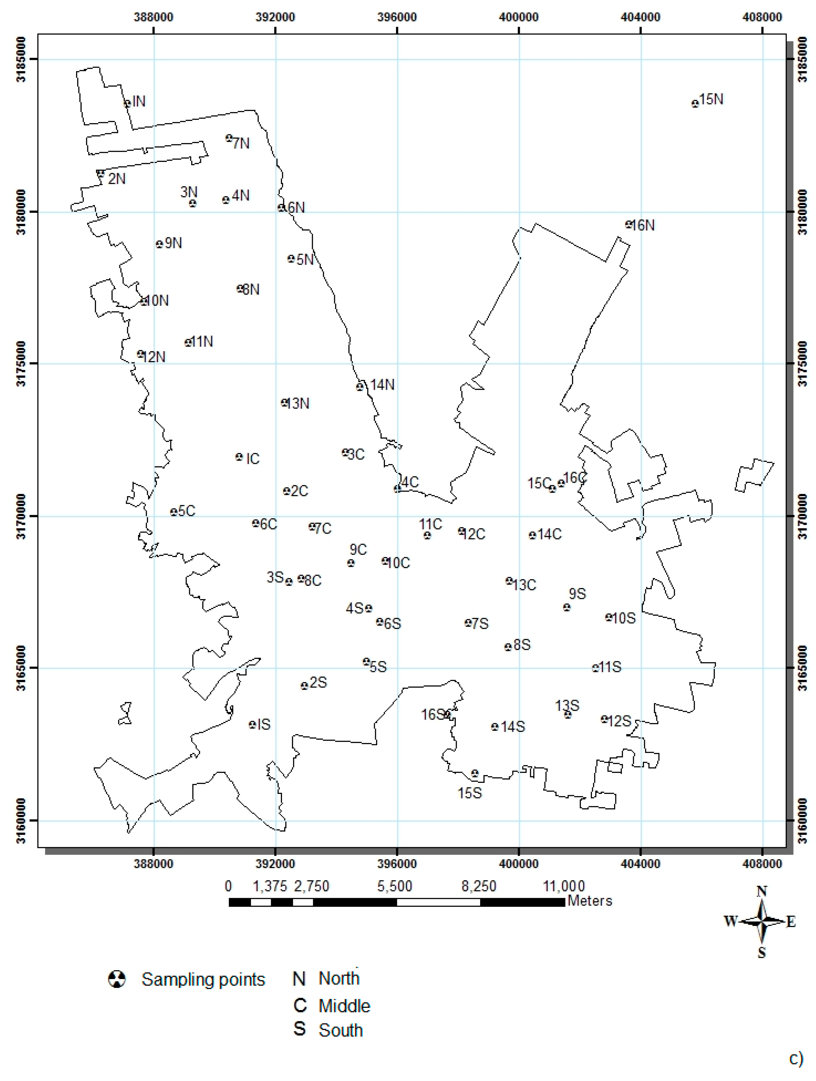
2.2. Sampling and Analysis
2.2.1. Outdoor Gamma Dose Rates
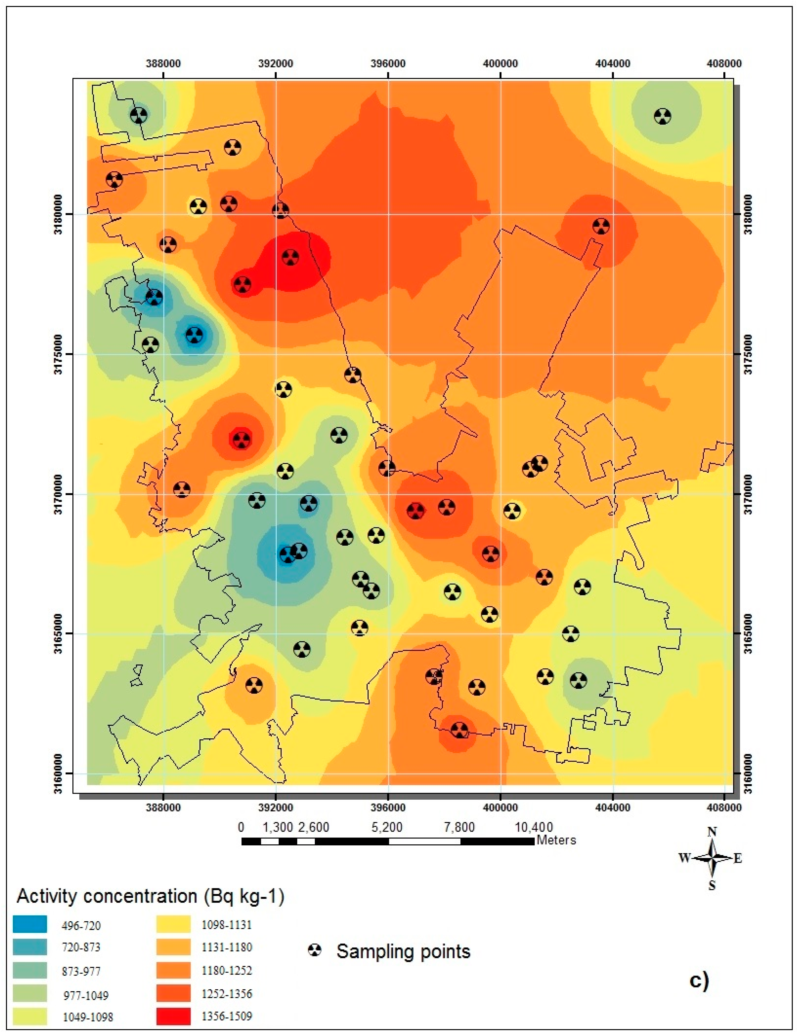
2.2.2. 226Ra, 232Th and 40K Activity Concentrations in Soil and the Terrestrial Gamma Dose Rate
2.2.3. Assessment of Lifetime Cancer Risk
3. Results and Discussion
3.1. Results

| Zone | N * | Mean ± SD § | Median | 25–75 Percentiles | Min–Max |
|---|---|---|---|---|---|
| N | 16 | 235 ± 40 | 244 | 207–263 | 141–301 |
| C | 16 | 204 ± 51 | 197 | 167–235 | 113–310 |
| S | 16 | 236 ± 52 | 254 | 214–277 | 113–282 |
| Zone | 226Ra | 232Th | 40K |
|---|---|---|---|
| N | 58 (27–90) | 79 (40–108) | 1107 (496–1509) |
| C | 54 (37–103) | 77 (48–142) | 1117 (794–1424) |
| S | 44 (26–51) | 63 (37–93) | 1066 (521–1295) |
| Zone | OGDR (nGy·h−1) | Lifetime Total Effective Dose (mSv) * | Lifetime Cancer Risk * | AED(µSv·y−1) | |||
|---|---|---|---|---|---|---|---|
| From Direct Measurements | From Soil Concentrations | Remaining Dose § | From Direct Measurements | From Soil Concentrations | |||
| N | 235 (141–301) | 121 (64–148) | 79 (19–125) | 21 | 1.04 E−3 | 288 (173–369) | 148 (78–182) |
| C | 204 (113–310) | 118 (79–193) | 57 (8–154) | 18 | 0.90 E−3 | 250 (138–380) | 145 (98–237) |
| S | 236 (113–282) | 103 (56–124) | 101 (2–157) | 21 | 1.04 E−3 | 289 (138–346) | 126 (69–152) |
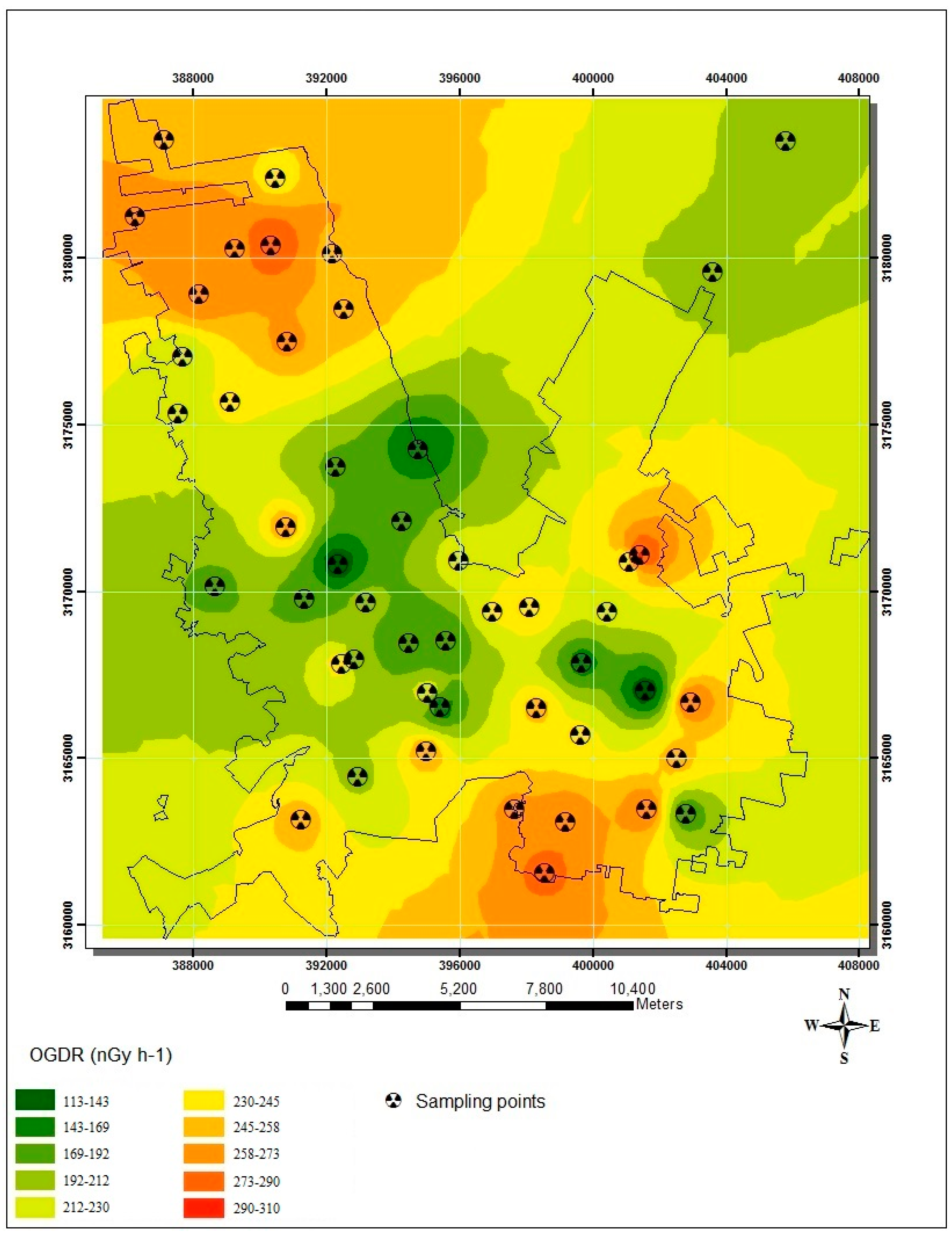
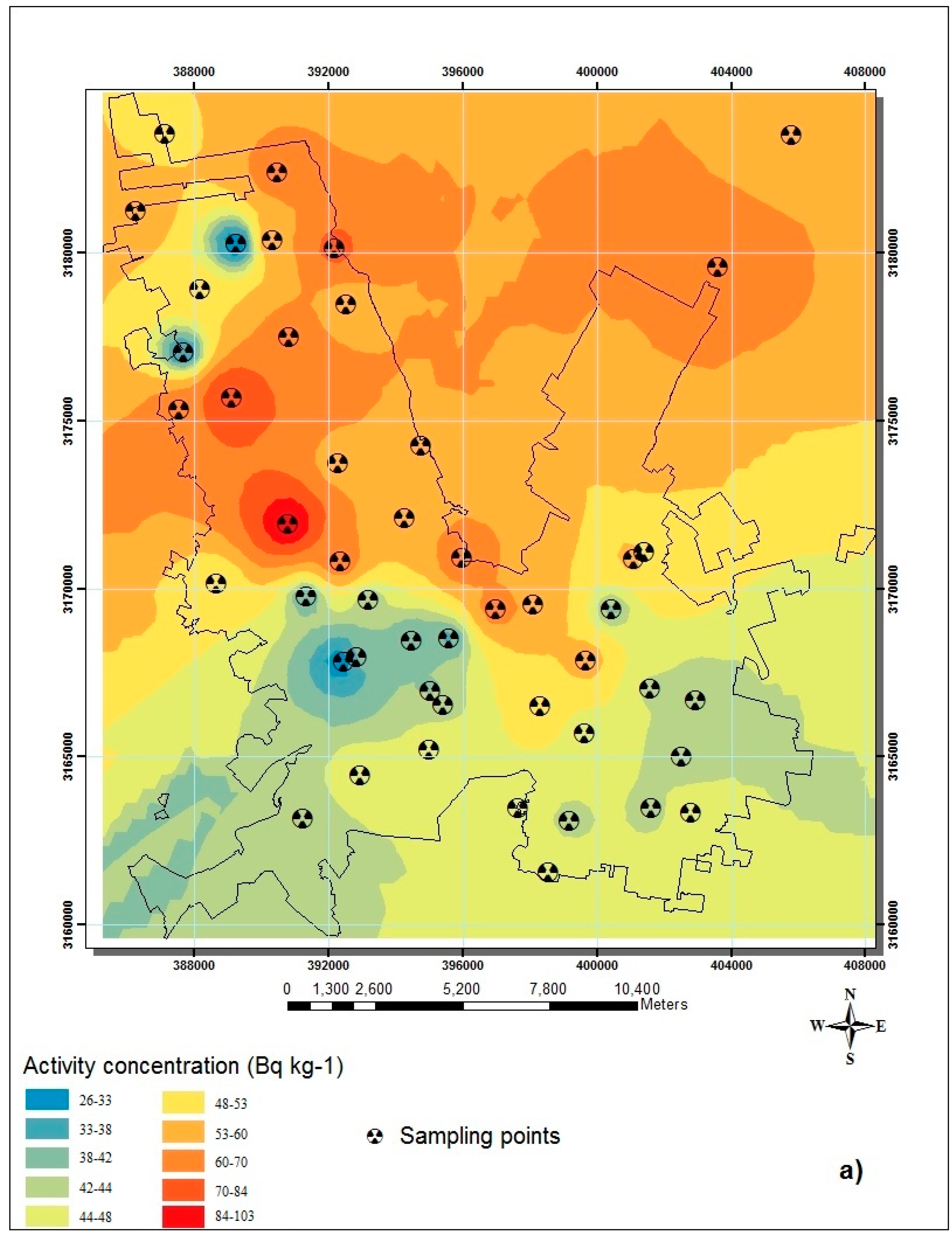
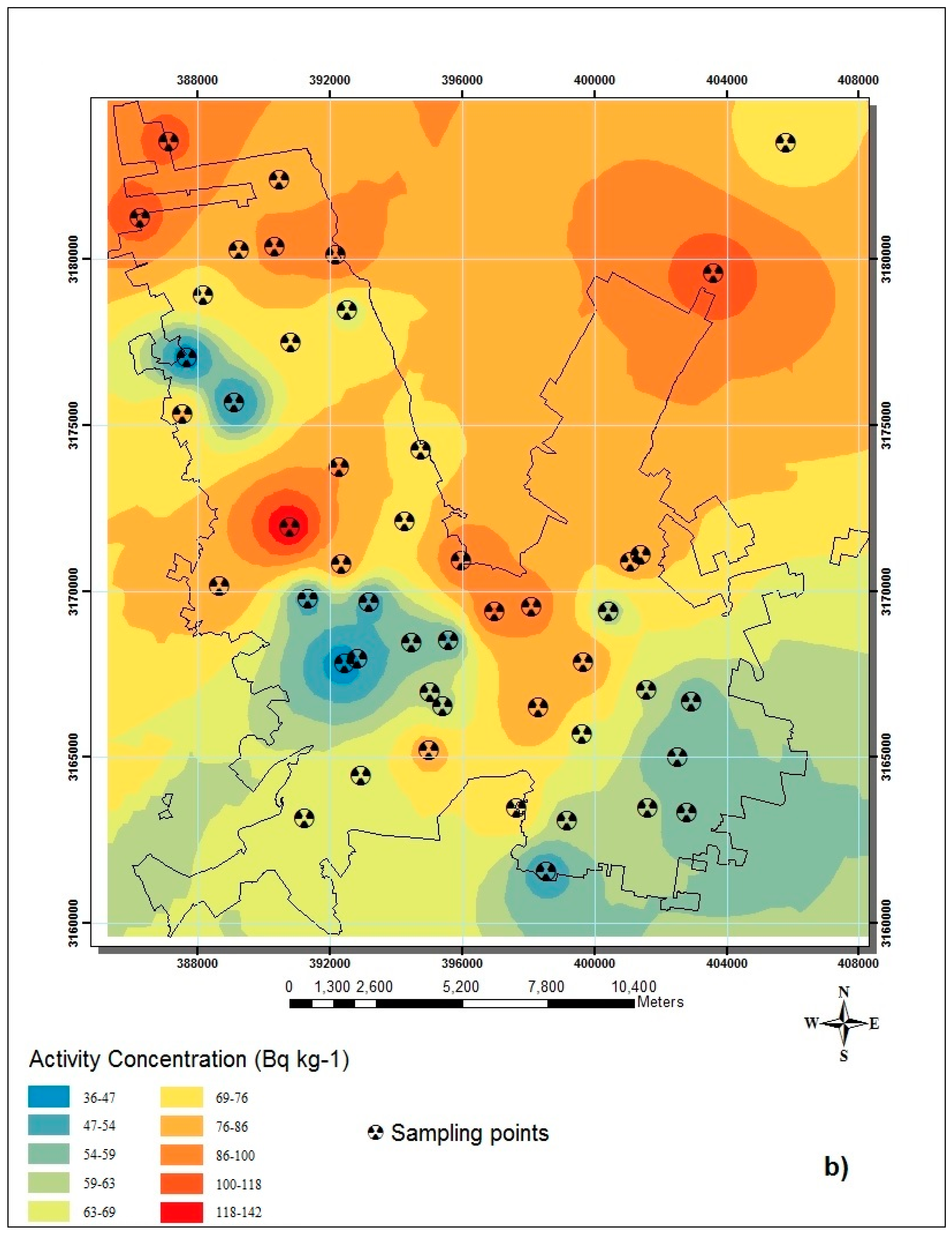
3.2. Discussion

4. Conclusions
Acknowledgments
Author Contributions
Conflicts of Interest
References
- UNSCEAR. Report of the United Nations Scientific Committee on the Effects of Atomic Radiation to the General Assemby. Annex B: Exposures from Natural Radiation Sources; UNSCEAR: New York, NY, USA, 2000. [Google Scholar]
- Bonotto, D.M.; Andrews, J.N. The transfer of uranium isotopes 234U and 238U to the waters interacting with carbonates from Mendip Hills area (England). Appl. Radiat. Isot. 2000, 52, 965–983. [Google Scholar] [CrossRef]
- Gascoyne, M. Geochemistry of the actinides and their daughters. In Uranium Series Disequilibrium. Application to Earth, Marine and Environmental Sciences; Ivanovich, M., Harmon, R.S., Eds.; Oxford University: New York, NY, USA, 1992; pp. 35–61. [Google Scholar]
- Eisenbud, M.; Gesell, T.F. Environmental Radioactivity, 4th ed.; Academic Press: San Diego, CA, USA, 1997. [Google Scholar]
- Ferríz, H. Uranium mineralization in the San Marcos Volcanic Center. In Uranium Deposits in Volcanic Rocks, Proceedings of a Technical Committee Meeting on Uranium Deposits in Volcanic Rocks, El Paso, Texas, TX, USA, 2–5 April 1985; IAEA- TC- 490-3. International Atomic Energy Agency: Vienna, Austria, 1985; pp. 197–216. [Google Scholar]
- Goodell, P.C. Chihuahua city uranium province, Chihuahua Mexico. In Uranium Deposits in Volcanic Rocks, Proceedings of a Technical Committee Meeting, El Paso, Texas, TX, USA, 2–5 April 1984; International Atomic Energy Agency: Vienna, Austria, 1985. STI/PUB/690. pp. 97–124. [Google Scholar]
- INEGI. Cartografía Geoestadıstica Urbana; Instituto Nacional de Estadıstica y Geografıa: Mexico, Mexico, 2011. [Google Scholar]
- ESRI. ArcGis V 9.3; Environment Science Research Institute: Redlands, CA, USA, 2000. [Google Scholar]
- Mountford, P.J.; Temperton, D.H. Recommendations of the International Commission on Radiological Protection (ICRP) 1990. Eur. J. Nucl. Med. Mol. Imaging. 1992, 19, 77–79. [Google Scholar] [CrossRef]
- INEGI. Censo General de Poblacion y Vivienda; Instituto Nacional de Estadısticas y Geografıa: Mexico, Mexico, 2010. [Google Scholar]
- Harb, S.; El-Bast Abbady, A.; El-Hadi El-Kamel, A.; Saleh, I.I.; Ibrahim Abd El-Mageed, A. Natural radioactivity and their radiological effects for different types of rocks from Egypt. Radiat. Phys. Chem. 2012, 81, 221–225. [Google Scholar] [CrossRef]
- Gunn, B.M. Geochemistry of Igneous Rocks; Available online:. Available online: http://geokem.com (accessed on 21 March 2008).
- Pérez del Villar, L.; Crespo, M.T.; Pardillo, J.; Pelayo, M.; Galán, M.P. U and Th series disequilibrium in unaltered and hydrothermally-altered granites from the El Berrocal site (Spain): Weathering effects. Appl. Radiat. Isot. 1996, 47, 1115–1119. [Google Scholar] [CrossRef]
- Renteria Villalobos, M.; Montero Cabrera, M.E.; Reyes Cortés, M.; Herrera Peraza, E.F.; Rodríguez Pineda, A.; Manjón Collado, G.; García Tenorio, R.; Crespo, T.; Valenzuela Hernández, M. Characterization of source rocks and groundwater radioactivity at the Chihuahua valley. Rev. Mex. Fis. 2007, S53, 16–22. [Google Scholar]
- Rentería Villalobos, M.; Montero-Cabrera, M.E.; Rodríguez-Pineda, A.; Reyes-Cortés, M.; Herrera-Peraza, E.F.; Valenzuela-Hernández, M. Uranium series specific activities of rocks forming ranges around Chihuahua City, Mexico. In 2nd International Conference on Radioactivity in the Environment; International Union of Radioecology: Nize, France, 2005; pp. 133–136. [Google Scholar]
- Reyes-Cortés, M.; Rentaría-Villalobos, M.; Valenzuela-Hernández, M.; Silva-Sáenz, M.; Burciaga-Valencia, D.C.; Fuentes-Montero, L.; Herrera-Peraza, E.F.; Reyes-Cortés, I.; Rascón-Muro, C.; Montero-Cabrera, M.E. Contenido de uranio en los estratos arcillosos de la cuenca de Chihuahua-Sacramento, Chihuahua, México. Rev. Latinoam. Recur. Nat. 2008, 4, 77–83. [Google Scholar]
- Burciaga-Valencia, D.C.; Reyes-Cortés, M.; Reyes-Rojas, A.; Rentería-Villalobos, M.; Esparza-Ponce, H.; Fuentes-Cobas, L.; Fuentes-Montero, L.; Silva-Sáenz, M.; Herrera-Peraza, E.; Muñoz, A.; Montero-Cabrera, M.E. Characterization of Uranium Minerals from Chihuahua using Synchrotron Radiation. Rev. Mex. Fis. 2010, 56, 75–81. [Google Scholar]
- Renterıa-Villalobos, M.; Reyes Cortés, M.; Mantero, J.; Manjón, G.; García-Tenorio, R.; Herrera, E.; Montero-Cabrera, M.E. Uranium in the Surrounding of SanMarcos-Sacramento River Environment (Chihuahua, Mexico). Sci. World J. 2012, 2012, 1–13. [Google Scholar] [CrossRef] [PubMed]
- Burillo Montufar, J.; Reyes Cortés, M.; Reyes Cortés, I.A.; Espino Valdez, M.S.; de la Garza, O.R.H.; Nevárez Ronquillo, D.P.; Herrera Peraza, E.; Rentería Villalobos, M.; Montero Cabrera, M.E. Uranium-series isotopes transport in surface, vadose and ground waters at San Marcos uranium bearing basin, Chihuahua, Mexico. Appl. Geochem. 2012, 27, 1111–1122. [Google Scholar] [CrossRef]
- Hameed, P.S.; Pillai, G.S.; Mathiyarasu, R. A study on the impact of phosphate fertilizers on the radioactivity profile of cultivated soils in Srirangam (Tamil Nadu, India). J. Radiat. Res. Appl. Sci. 2014, 7, 463–471. [Google Scholar] [CrossRef]
- Bolca, M.; Saç, M.M.; Çokuysal, B.; Karalı, T.; Ekdal, E. Radioactivity in soils and various foodstuffs from the Gediz River Basin of Turkey. Radiat. Meas. 2007, 42, 263–270. [Google Scholar] [CrossRef]
- Al-Hamarneh, I.F.; Awadallah, M.I. Soil radioactivity levels and radiation hazard assessment in the highlands of northern Jordan. Radiat. Meas. 2009, 44, 102–110. [Google Scholar] [CrossRef]
- Taskin, H.; Karavus, M.; Ay, P.; Topuzoglu, A.; Hidiroglu, S.; Karahan, G. Radionuclide concentrations in soil and lifetime cancer risk due to gamma radioactivity in Kirklareli, Turkey. J. Environ. Radioact. 2009, 100, 49–53. [Google Scholar] [CrossRef] [PubMed]
- Singh, J.; Singh, H.; Singh, S.; Bajwa, B.S.; Sonkawade, R.G. Comparative study of natural radioactivity levels in soil samples from the Upper Siwaliks and Punjab, India using gamma-ray spectrometry. J. Environ. Radioact. 2009, 100, 94–98. [Google Scholar] [CrossRef] [PubMed]
© 2015 by the authors; licensee MDPI, Basel, Switzerland. This article is an open access article distributed under the terms and conditions of the Creative Commons Attribution license (http://creativecommons.org/licenses/by/4.0/).
Share and Cite
Luevano-Gurrola, S.; Perez-Tapia, A.; Pinedo-Alvarez, C.; Carrillo-Flores, J.; Montero-Cabrera, M.E.; Renteria-Villalobos, M. Lifetime Effective Dose Assessment Based on Background Outdoor Gamma Exposure in Chihuahua City, Mexico. Int. J. Environ. Res. Public Health 2015, 12, 12324-12339. https://doi.org/10.3390/ijerph121012324
Luevano-Gurrola S, Perez-Tapia A, Pinedo-Alvarez C, Carrillo-Flores J, Montero-Cabrera ME, Renteria-Villalobos M. Lifetime Effective Dose Assessment Based on Background Outdoor Gamma Exposure in Chihuahua City, Mexico. International Journal of Environmental Research and Public Health. 2015; 12(10):12324-12339. https://doi.org/10.3390/ijerph121012324
Chicago/Turabian StyleLuevano-Gurrola, Sergio, Angelica Perez-Tapia, Carmelo Pinedo-Alvarez, Jorge Carrillo-Flores, Maria Elena Montero-Cabrera, and Marusia Renteria-Villalobos. 2015. "Lifetime Effective Dose Assessment Based on Background Outdoor Gamma Exposure in Chihuahua City, Mexico" International Journal of Environmental Research and Public Health 12, no. 10: 12324-12339. https://doi.org/10.3390/ijerph121012324