Discrepancy Between ASTER- and MODIS- Derived Land Surface Temperatures: Terrain Effects


Abstract
:1. Introduction
2. Methods
2.1. Terrain correction
2.2. Upscaling of satellite-retrieved LST
2.3. GSW algorithm based correction approach
3. Study materials and data processing
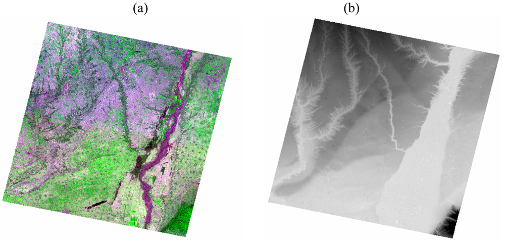
3.1. Study area and materials
3.2. Data Processing
4. Results and Discussion
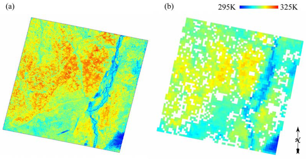
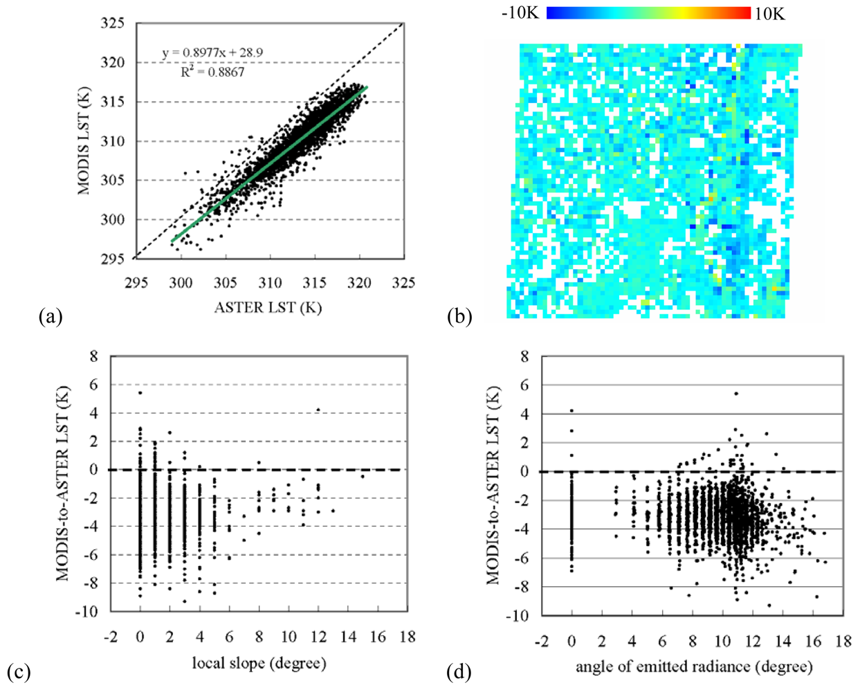
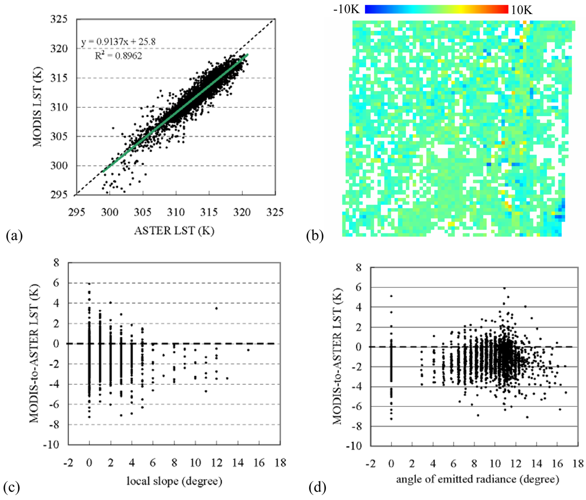
4.1. The discrepancy between the original MODIS and the upscaled ASTER LST
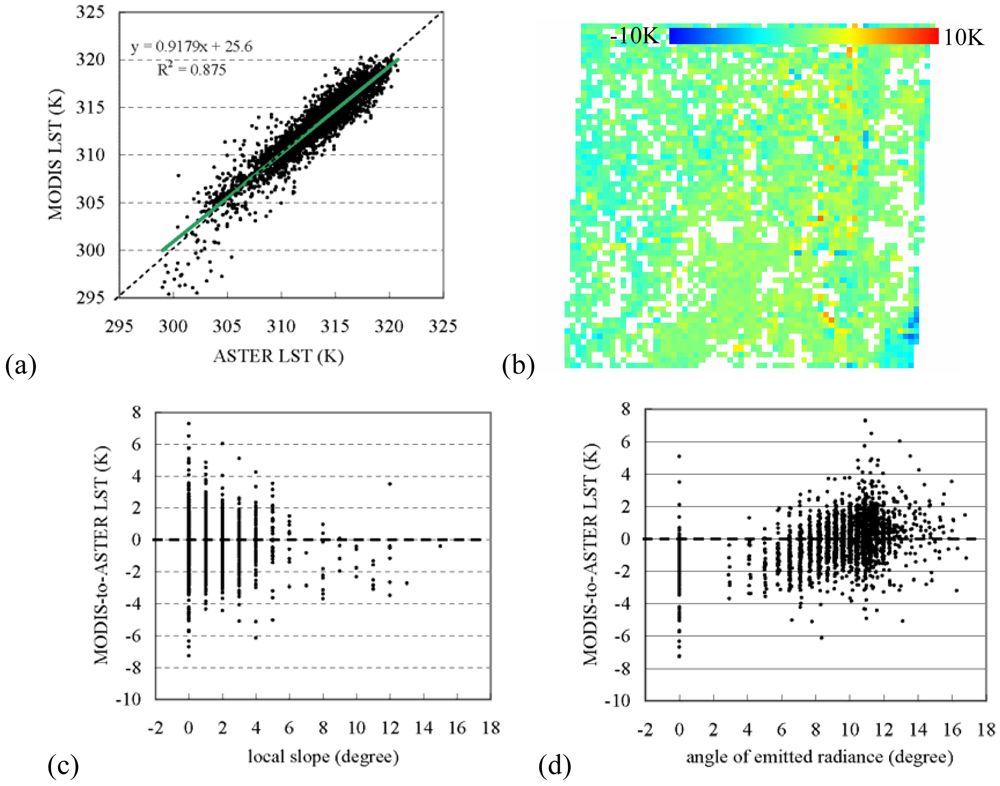
4.2. The discrepancy between the rectified MODIS and the upscaled ASTER LST
4.3. The discrepancy between the rectified MODIS LST with terrain correction and the upscaled ASTER LST
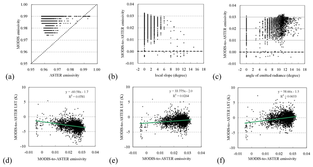
4.4. Terrain effect relevant to emissivity
5. Conclusions
Acknowledgments
References
- NASA. TERRA: The EOS Flagship. Available online: http://terra.nasa.gov.
- Justice, C.; Vermote, E.; Townshend, J.; Defries, R.; Roy, D.; Hall, D.; Salomonson, V.; Privette, J.; Riggs, G.; Strahler, A.; Lucht, W.; Myneni, R.; Knyazikhin, Y.; Running, S.; Nemani, R.; Wan, Z.; Huete, A.; van Leeuwen, W.; Wolfe, R.; Giglio, L.; Muller, J.–P.; Lewis, P.; Barnsley, M. The MODerate Imaging Spectroradiometer (MODIS): land remote sensing for global change research. IEEE Trans. Geosci. Remote Sens. 1998, 36, 1228–1249. [Google Scholar]
- Yamaguchi, Y.; Kahle, A.; Tsu, H.; Kawakami, T.; Pniel, M. Overview of Advanced Space-borne Thermal Emission and Reflection Radiometer (ASTER). IEEE Trans. Geosci. Remote Sens. 1998, 36, 1062–1071. [Google Scholar]
- Gillespie, A.; Rokugawa, S.; Matsunaga, T.; Cothern, S.; Hook, S.; Kahle, A. A temperature and emissivity separation algorithm for Advanced Spaceborne Thermal Emission and Reflection Radiometer (ASTER) images. IEEE Trans. Geosci. Remote Sens. 1998, 36, 1113–1126. [Google Scholar]
- Wan, Z. MODIS land-surface temperature algorithm theoretical basis document (LST ATBD). Version 3. 1999. Available online: http://modis.gsfc.nasa.gov/data/atbd/atbd_mod11.pdf.
- Wan, Z.; Li, Z.-L. A physics-based algorithm for retrieving land-surface emissivity and temperature from EOS/MODIS data. IEEE Trans. Geosci. Remote Sens. 1997, 35, 980–996. [Google Scholar]
- Wan, Z.; Zhang, Y.; Zhang, Q.; Li, Z.–L. Validation of the land-surface temperature products retrieved from Terra Moderate Resolution Imaging Spectroradiometer data. Remote Sens. Environ. 2002, 83, 163–180. [Google Scholar]
- Houborg, R.M.; Soegaard, H. Regional simulation of ecosystem CO2 and water vapor exchange for agricultural land using NOAA AVHRR and Terra MODIS satellite data. Application to Zealand, Denmark. Remote Sens. Environ. 2004, 93, 150–167. [Google Scholar]
- Cleugh, H.A.; Leuning, R.; Mu, Q.; Running, S.W. Regional evaporation estimates from flux tower and MODIS satellite data. Remote Sens. Environ. 2007, 106, 285–304. [Google Scholar]
- Hashimoto, H.; Dungan, J.L.; White, M.A.; Yang, F.; Michaelis, A.R.; Running, S.W.; Nemani, R.R. Satellite-based estimation of surface vapor pressure deficits using MODIS land surface temperature data. Remote Sens. Environ. 2008, 112, 142–155. [Google Scholar]
- Liu, Y.; Hiyama, T.; Yamaguchi, Y. Scaling of land surface temperature using satellite data: A case examination on ASTER and MODIS products over a heterogeneous terrain area. Remote Sens. Environ. 2006, 105, 115–128. [Google Scholar]
- Liu, Y.; Yamaguchi, Y.; Ke, C. Reducing the discrepancy between ASTER and MODIS MODIS land surface temperature products. Sensors 2007, 7, 3043–3057. [Google Scholar]
- Jacob, F.; Petitcolin, F.; Schmugge, T.; Vermote, E.; French, A.; Ogawa, K. Comparison of land surface emissivity and radiometric temperature derived from MODIS and ASTER sensors. Remote Sens. Environ. 2004, 90, 137–152. [Google Scholar]
- Norman, J.M.; Becker, F. Terminology in thermal infrared remote sensing of natural surfaces. Agr. Forest Meteorol. 1995, 77, 153–166. [Google Scholar]
- Dash, P.; Göttsche, F.–M.; Olesen, F. –S.; Fischer, H. Land surface temperature and emissivity estimation from passive sensor data: theory and practice – current trends. Int. J. Remote Sens. 2002, 23, 2563–2594. [Google Scholar]
- Lipton, A.E.; Ward, J.M. Satellite-view biases in retrieved surface temperatures in mountain areas. Remote Sens. Environ. 1997, 60, 92–100. [Google Scholar]
- Sandmeier, S.; Itten, K.I. A physically-based model to correct atmospheric and illumination effects in optical satellite data of rugged terrain. IEEE Trans. Geosci. Remote Sens. 1997, 35, 708–717. [Google Scholar]
- Teillet, P.M.; Guindon, B.; Goodeonugh, D.G. On the slope-aspect correction of multispectral scanner data. Can. J. Remote Sens. 1982, 8, 84–106. [Google Scholar]
- Liu, Y.; Hiyama, T. A scaling approach for satellite-derived land surface temperature over terrain area. Proc. SPIE. 2005, 5967, 58670O-1–8. [Google Scholar]
- Dozier, J.; Frew, J. Rapid calculation of terrain parameters for radiation modeling from digital elevation data. IEEE Trans. Geosci. Remote Sens. 1990, 28, 963–969. [Google Scholar]
- Sandmeier, S.; Itten, K.I. A physically-based model to correct atmospheric and illumination effects in optical satellite data of rugged terrain. IEEE Trans. Geosci. Remote Sens. 1997, 35, 708–717. [Google Scholar]
- Shepherd, J.D.; Dymond, J.R. Correcting satellite imagery for the variance of reflectance and illumination with topography. Int. J. Remote Sens. 2003, 24, 3503–3514. [Google Scholar]
- Kondratyev, K.Y. Radiation in the Atmosphere.; Academic Press: London, 1969. [Google Scholar]
- Richter, R. Correction of satellite imagery over mountainous terrain. Appl. Optics 1998, 37, 4004–4015. [Google Scholar]
- Wan, Z.; Dozier, J. A generalized split-window algorithm for retrieving land-surface temperature from space. IEEE Trans. Geosci. Remote Sens. 1996, 34, 892–905. [Google Scholar]
- Wolfe, R.E.; Nishihama, M.; Fleig, A.J.; Kuyper, J.A.; Roy, D.P.; Storey, J.C.; Patt, F.S. Achieving sub-pixel geolocation accuracy in support of MODIS land science. Remote Sens. Environ. 2002, 83, 31–49. [Google Scholar]
- Earth Remote Sensing Data Analysis Center. ASTER Product Guide: Release Note. 2006. Available online at: http://www.gds.aster.ersdac.or.jp/gds_www2002/service_e/release_e/g.t.u.p9_e.html.
- Nicodemus, F.E.; Richmond, J.C.; Hsia, J.J.; Ginsberg, I.W.; Limperis, T. Geometrical Considerations and Nomenclature for Reflectance.; National Bureau of Standards (NBS) Monograph; Volume 160, 1977. [Google Scholar]


© 2009 by the authors; licensee Molecular Diversity Preservation International, Basel, Switzerland. This article is an open access article distributed under the terms and conditions of the Creative Commons Attribution license (http://creativecommons.org/licenses/by/3.0/).
Share and Cite
Liu, Y.; Noumi, Y.; Yamaguchi, Y. Discrepancy Between ASTER- and MODIS- Derived Land Surface Temperatures: Terrain Effects. Sensors 2009, 9, 1054-1066. https://doi.org/10.3390/s90201054
Liu Y, Noumi Y, Yamaguchi Y. Discrepancy Between ASTER- and MODIS- Derived Land Surface Temperatures: Terrain Effects. Sensors. 2009; 9(2):1054-1066. https://doi.org/10.3390/s90201054
Chicago/Turabian StyleLiu, Yuanbo, Yousuke Noumi, and Yasushi Yamaguchi. 2009. "Discrepancy Between ASTER- and MODIS- Derived Land Surface Temperatures: Terrain Effects" Sensors 9, no. 2: 1054-1066. https://doi.org/10.3390/s90201054