Deriving Vegetation Dynamics of Natural Terrestrial Ecosystems from MODIS NDVI/EVI Data over Turkey

Abstract
:1. Introduction
2. Data and Methodology
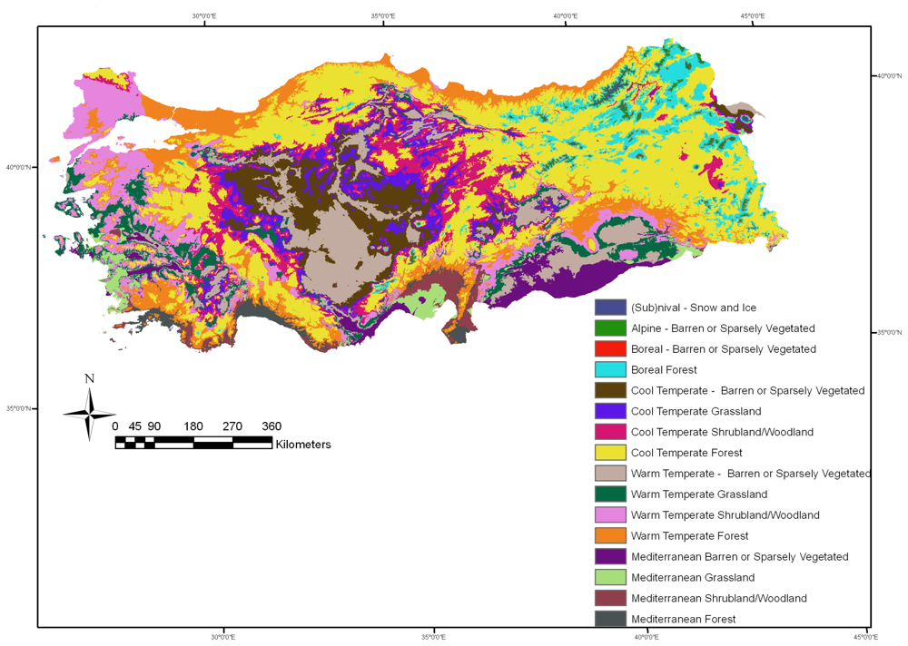
2.1. Description of Study Region
2.2. Description and Preprocessing of Data
2.3. Statistical Data Analyses
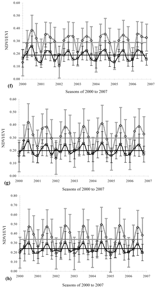
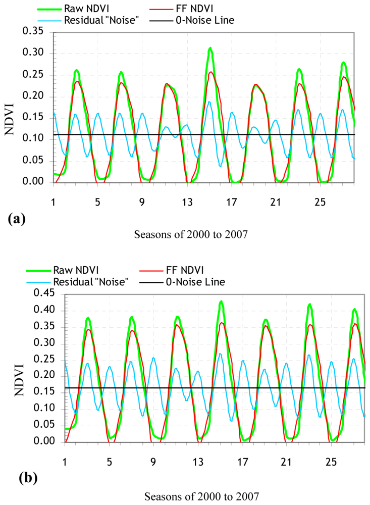
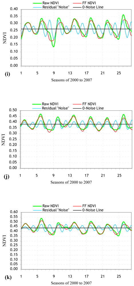
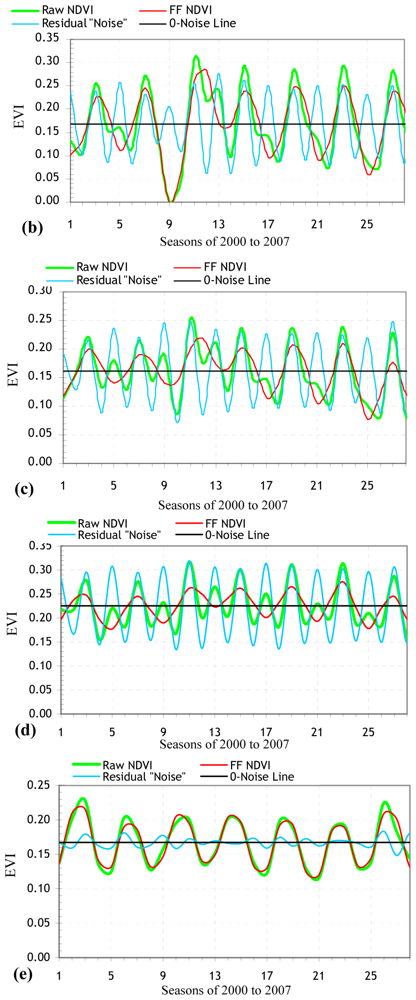
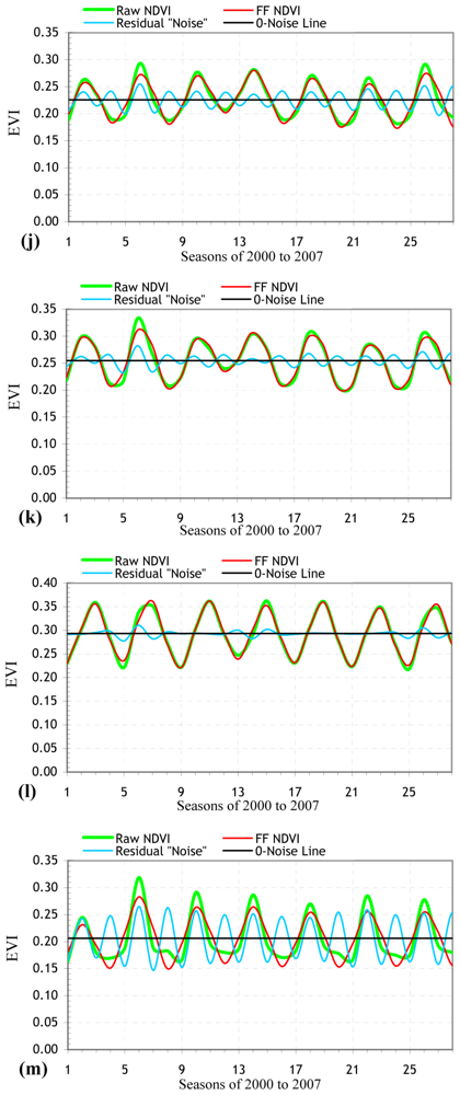
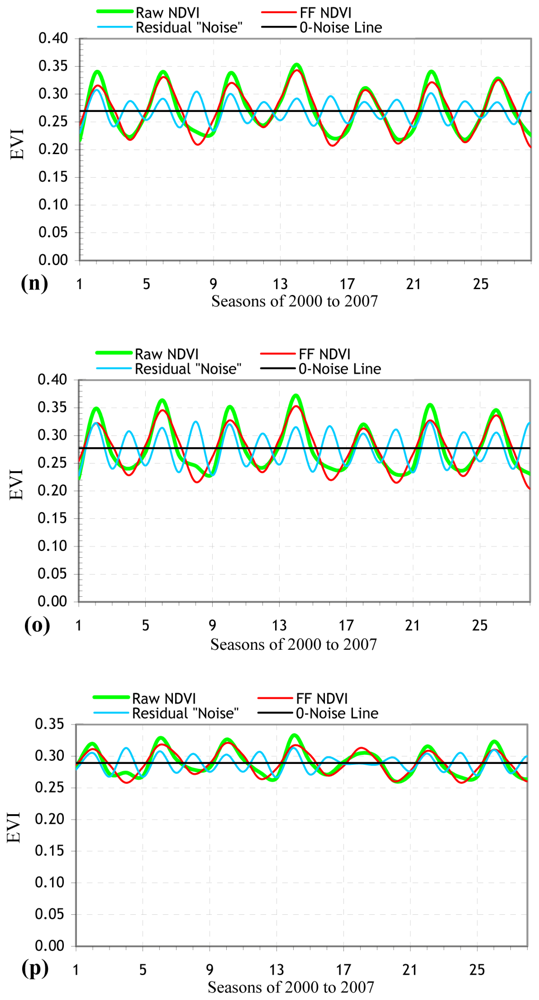
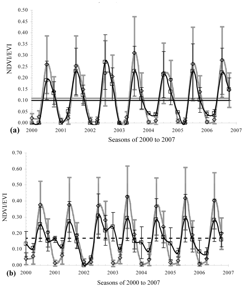
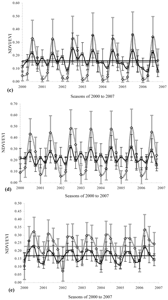
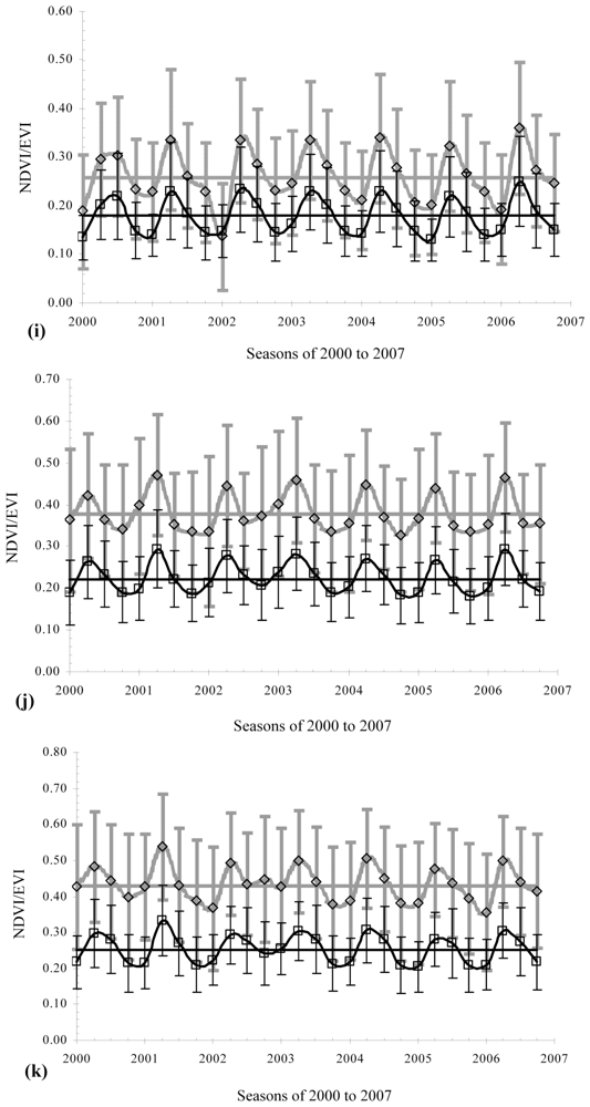
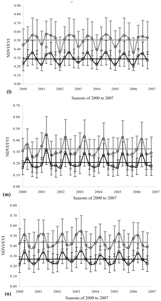
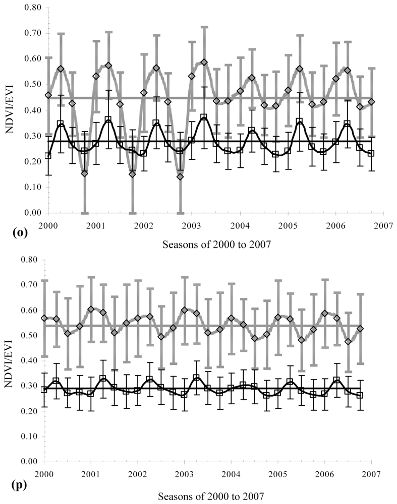
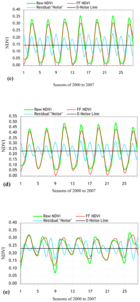
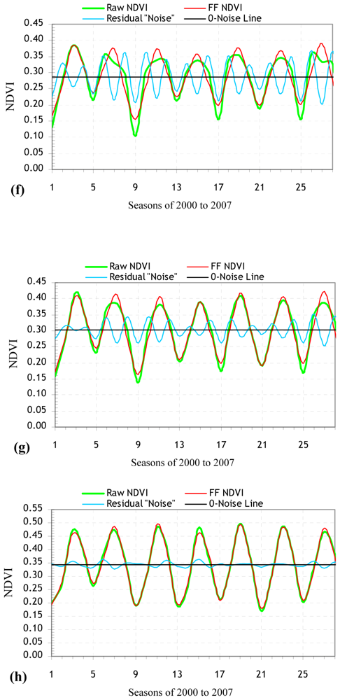
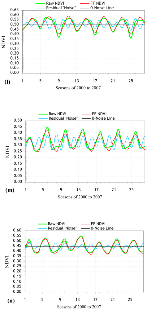
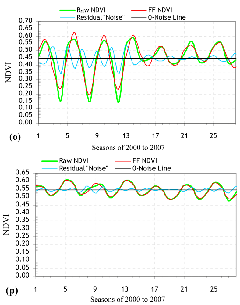
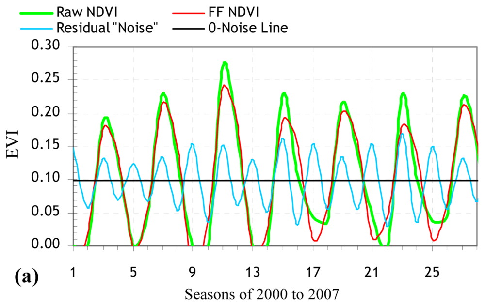
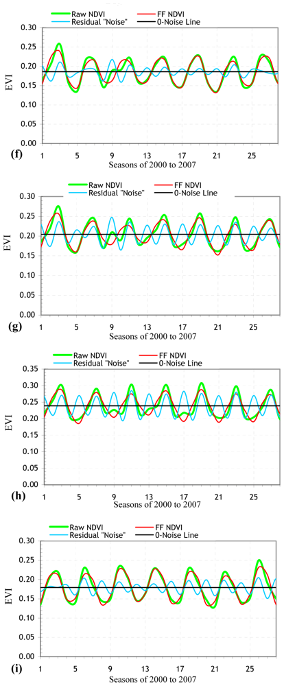
3. Results and Discussion
4. Conclusions
Acknowledgments
References
- Goward, S.N.; Huemmrich, K.F. Vegetation canopy PAR absorptance and the normalized difference vegetation index: an assessment using the SAIL model. Remote Sens. Environ. 1992, 39, 119–140. [Google Scholar]
- Running, S.W.; Loveland, T.R.; Pierce, L.L. A vegetation classification logic-based on remote-sensing for use in global biogeochemical models. Ambio 1994, 23, 77–81. [Google Scholar]
- Running, S.W.; Loveland, T.R.; Pierce, L.L.; Nemani, L. A remote-sensing based vegetation classification logic for global land-cover analysis. Remote Sens. Environ. 1995, 51, 39–48. [Google Scholar]
- Verhoef, W.; Menenti, M.; Azzali, S. A colour composite of NOAA-AVHRR-NDVI based on time series analysis (1981-1992). Int. J. Remote Sens. 1996, 17, 231–235. [Google Scholar]
- Carlson, T.N.; Ripley, D.A. On the relation between NDVI, fractional vegetation cover, and leaf area index. Remote Sens. Environ. 1997, 62, 241–252. [Google Scholar]
- Nemani, R.; Running, S. Land cover characterization using multitemporal red, near-IR, and thermal-IR data from NOAA/AVHRR. Ecol. Appl. 1997, 7, 79–90. [Google Scholar]
- Myneni, R.B.; Knyazikhin, Y.; Privette, J.L.; Glassy, J.; Tian, Y.; Wang, Y.; Hoffman, S.; Song, X.; Zhang, Y.; Smith, G.R.; Lotsch, A.; Friedl, M.; Morisette, J.T.; Votava, P.; Nemani, R.R.; Running, S.W. Global products of vegetation leaf area and fraction absorbed PAR from year one of MODIS data. Remote Sens. Environ. 2002, 83, 214–231. [Google Scholar]
- Lagergren, F.; Eklundh, L.; Grelle, A.; Lundblad, M.; Mölder, M.; Lankreijer, H.; Lindroth, A. Net primary production and light use efficiency in a mixed coniferous forest in Sweden. Plant Cell Environ. 2005, 28, 412–423. [Google Scholar]
- Sakamoto, T.; Yokozawa, M.; Toritani, H.; Shibayama, M.; Ishitsuka, N.; Oho, H. A crop phenology detection method using time-series MODIS data. Remote Sens. Environ. 2005, 96, 366–374. [Google Scholar]
- Myneni, R.B.; Maggion, S.; Iaquinta, J.; Privette, J.L.; Gobron, N.; Pinty, B.; Verstraete, M.M.; Kimes, D.S.; Williams, D.L. Optical remote sensing of vegetation: modeling, caveats and algorithms. Remote Sens. Environ. 1995, 51, 169–188. [Google Scholar]
- Jin, S.; Sader, S.A. MODIS time-series imagery for forest disturbance and quantification of patch effects. Remote Sens. Environ. 2005, 99, 462–470. [Google Scholar]
- Olofsson, P.; Eklundh, L.; Lagergren, F.; Jönsson, P.; Lindroth, L. Estimating net primary production for Scandinavian forests using data from Terra/MODIS. Adv. Space Res. 2007, 39, 125–130. [Google Scholar]
- MODIS. MODIS Vegetation Index (MOD 13): Algorithm Theoretical Basis Document (Version 3). 1999. http://modis.gsfc.nasa.gov/data/atbd/atbd_mod13.pdf.
- Running, S.W.; Nemani, R.; Glassy, J.M.; Thornton, P. MODIS Daily Photosynthesis (PSN) and Annual Net Primary Production (NPP) Product (MOD17), Algorithm Theoretical Basis Document; Version 3.0; 1999. [Google Scholar]
- Behrenfeld, M.J.; Randerson, J.T.; McClain, C.R.; Feldman, G.C.; Los, S.O.; Tucker, C.J.; Falkowski, P.G.; Field, C.B.; Frouin, R.; Esaias, W.E.; Kolber, D.D.; Pollack, N.H. Biospheric primary production during an ENSO transition. Science 2001, 291, 2594–2597. [Google Scholar]
- Huete, A.; Didan, K.; Miura, T.; Rodriguez, E.P.; Gao, X.; Ferreira, L.G. Overview of the radiometric and biophysical performance of the MODIS vegetation indices. Remote Sens. Environ. 2002, 83, 195–213. [Google Scholar]
- Ruimy, A.; Saugier, B.; Dedieu, G. Methodology for the estimation of terrestrial primary production from remotely sensed data. J. Geophys. Res. 1994, 99, 5263–5283. [Google Scholar]
- Prince, S.D.; Goward, S.N. Global primary production: a remote sensing approach. J. Biogeogr. 1995, 22, 815–835. [Google Scholar]
- Field, C.B.; Randerson, J.T.; Malmstrom, C.M. Global Net primary production-combining ecology and remote-sensing. Remote Sens. Environ. 1995, 51, 74–88. [Google Scholar]
- Running, S.W.; Ramakrishna, R.N.; Heinsch, F.A.; Zhao, M.; Reeves, M.; Hashimotoa, H. Continuous satellite-derived measure of global terrestrial primary production. BioScience 2004, 54, 547–560. [Google Scholar]
- Huete, A.; Justice, C.; Liu, H. Development of vegetation and soil indexes for MODIS-EOS. Remote Sens. Environ. 1994, 49, 224–234. [Google Scholar]
- Huete, A.R. A soil-adjusted vegetation index (SAVI). Remote Sens. Environ. 1988, 25, 295–309. [Google Scholar]
- Liu, H.Q.; Huete, A. A feedback based modification of the NDVI to minimize canopy background and atmospheric noise. IEEE T. Geosci. Remote 1995, 33, 457–465. [Google Scholar]
- Evrendilek, F.; Berberoglu, S.; Gulbeyaz, O.; Ertekin, C. Modeling potential distribution and carbon dynamics of natural terrestrial ecosystems: a case study of Turkey. Sensors 2007, 7, 2273–2296. [Google Scholar]
- Holdridge, L.R. Determination of world plant formations from simple climate data. Science 1947, 105, 367–368. [Google Scholar]
- Box, E.O. Factors determining distributions of tree species and plant functional types. Vegetation 1995, 121, 101–116. [Google Scholar]
- Box, E.O. Predicting physiognomic vegetation types with climate variables. Vegetatio 1981, 45, 127–139. [Google Scholar]
- Loveland, T.R.; Reed, B.C.; Brown, J.F.; Ohlen, D.O.; Zhu, Z.; Yang, L.; Merchant, J.W. Development of a global land cover characteristics database and IGBP DISCover from 1-km AVHRR Data. Int. J. Remote Sens. 2000, 6, 1303–1330. [Google Scholar]
- TSMS (Turkish State Meteorological Service). Monthly Climate Data between 1968 and 2004; Turkish State Meteorological Service: Ankara, 2005. [Google Scholar]
- NASA EOS. Earth Observing System Data Gateway. 2007. http://eos.nasa.gov/imswelcome.
- MODIS Reprojection Tool (MRT). Users Guide; Release 3.2a; Department of Mathematics and Computer Science, South Dakota School of Mines and Technology, USGS EROS Data Center, 2004; p. 58. [Google Scholar]
- ESRI Inc. ArcGIS 8.2; ESRI Inc.: Redlands, CA, 2002. [Google Scholar]
- Azzali, S.; Menenti, M. Mapping vegetation-soil-climate complexes in southern Africa using temporal Fourier analysis of NOAA-AVHRR NDVI data. Int. J. Remote Sens. 2000, 21, 973–996. [Google Scholar]
- Roerink, G.J.; Menenti, M.; Verhoef, W. Reconstructing cloud free NDVI composites using Fourier analysis of time series. Int. J. Remote Sens. 2000, 21, 1911–1917. [Google Scholar]
- Jakubauskas, M.E.; Legates, D.R.; Kastens, J. Harmonic analysis of time-series AVHRR NDVI data. Photogramm. Eng. Rem. S. 2001, 67, 461–470. [Google Scholar]
- Evans, J.P.; Geerken, R. Classifying rangeland vegetation type and coverage using a Fourier component based similarity measure. Remote Sens. Environ. 2006, 105, 1–8. [Google Scholar]
- Wardlow, B.D.; Egbert, S.L.; Kastens, J.H. Analysis of Time-Series MODIS 250 m Vegetation index data for crop classification in the U.S. Central Great Plains. Remote Sens. Environ. 2007, 108, 290–310. [Google Scholar]
- DeFries, R.; Hansen, M.; Townshend, J.R.G. Global discrimination of land cover from metrics derived from AVHRR Pathfinder-data sets. Remote Sens. Environ. 1995, 54, 209–222. [Google Scholar]
- DeFries, R.S.; Townshend, J.R.G. NDVI-derived land cover classification at global scales. Int. J. Remote Sens. 1994, 15, 3567–3586. [Google Scholar]
- Potter, C.; Klooster, S.; Myneni, R.; Genovese, V.; Tan, P.N.; Kumar, V. Continental-scale comparisons of terrestrial carbon sinks estimated from satellite data and ecosystem modeling 1982–1998. Global Planet. Change 2003, 39, 201–213. [Google Scholar]
- Potter, C.; Tan, P.; Kumar, V.; Kucharik, C.; Klooster, S.; Genovese, V.; Cohen, W.; Healey, S. Recent history of large-scale ecosystem disturbances in North America derived from the AVHRR satellite record. Ecosystems 2005, 8, 808–824. [Google Scholar]
- Potter, C.; Kumar, V.; Klooster, S.; Nemani, R. Recent history of trends in vegetation greenness and large-scale ecosystem disturbances in Eurasia. Tellus B 2007, 59, 260–272. [Google Scholar]
- Myneni, R.B.; Hall, F.G.; Sellers, P.J.; Marshak, A.L. The interpretation of spectral vegetation indices. IEEE T. Geosci. R. 1995, 33, 481–486. [Google Scholar]
- Pettorelli, N.; Vik, J.O.; Mysterud, A.; Gaillard, J.-M.; Tucker, C.J.; Stenseth, N.C. Using the satellite-derived NDVI to assess ecological responses to environmental change. Trends Ecol. Evol. 2005, 20, 503–510. [Google Scholar]


| Biogeoclimate zones | Land cover types | Number of pixels | Area (km2) | Mean NDVI | Mean EVI | Mean altitude (m) | BT (°C) | PER |
|---|---|---|---|---|---|---|---|---|
| (Sub)nival | Snow/ice | 5899 | 1475 | 0.11 ± 0.06 | 0.10 ± 0.04 | 3104 ± 258 | 0.6 ± 0.9 | 0.27 ± 0.14 |
| Alpine | Barren/sparsely vegetated | 20372 | 5093 | 0.17 ± 0.08 | 0.17 ± 0.07 | 2831 ± 220 | 2.3 ± 0.4 | 0.33 ± 0.10 |
| Boreal | Barren/sparsely vegetated | 9043 | 2261 | 0.15 ± 0.08 | 0.16 ± 0.07 | 2391 ± 264 | 4.8 ± 0.8 | 0.52 ± 0.14 |
| Forest | 167254 | 41814 | 0.23 ± 0.11 | 0.23 ± 0.08 | ||||
| Cool Temperate | Barren/sparsely vegetated | 212169 | 53042 | 0.23 ± 0.08 | 0.17 ± 0.05 | 1423 ± 413 | 9.6 ± 1.5 | 1.11 ± 0.35 |
| Grassland | 175572 | 43893 | 0.29 ± 0.11 | 0.19 ± 0.06 | ||||
| Shrubland/woodland | 278098 | 69525 | 0.30 ± 0.13 | 0.20 ± 0.07 | ||||
| Forest | 979753 | 244938 | 0.34 ± 0.18 | 0.24 ± 0.09 | ||||
| Warm Temperate | Barren/sparsely vegetated | 312485 | 78121 | 0.26 ± 0.11 | 0.18 ± 0.07 | 663 ± 371 | 13.5 ± 1.1 | 1.40 ± 0.41 |
| Grassland | 162401 | 40600 | 0.38 ± 0.14 | 0.22 ± 0.08 | ||||
| Shrubland/woodland | 281280 | 70320 | 0.43 ± 0.15 | 0.25 ± 0.08 | ||||
| Forest | 322362 | 80591 | 0.51 ± 0.18 | 0.29 ± 0.10 | ||||
| Mediterranean | Barren/sparsely vegetated | 101905 | 25476 | 0.33 ± 0.13 | 0.21 ± 0.09 | 303 ± 211 | 17.3 ± 1.0 | 1.59 ± 0.45 |
| Grassland | 55559 | 13890 | 0.44 ± 0.15 | 0.27 ± 0.09 | ||||
| Shrubland/woodland | 54595 | 13649 | 0.45 ± 0.13 | 0.28 ± 0.08 | ||||
| Forest | 43459 | 10865 | 0.54 ± 0.13 | 0.29 ± 0.06 | ||||
| Grand total/mean | 3182206 | 795552 | 0.32 ± 0.13 | 0.21 ±0.05 | 1141 ± 655 | 11.3 ± 3.3 | 1.21 ± 0.44 | |
| Four categories of explanatory variables | EVI | NDVI | ||||||
|---|---|---|---|---|---|---|---|---|
| mean | ± SD | min | max | mean | ± SD | min | max | |
| Natural Land Cover | ||||||||
| Snow/ice | 0.10 | 0.04 | 0.02 | 0.23 | 0.15 | 0.08 | 0.00 | 0.45 |
| Barren/sparsely vegetated | 0.18 | 0.07 | 0.02 | 0.52 | 0.23 | 0.10 | 0.00 | 0.68 |
| Grassland | 0.23 | 0.08 | 0.01 | 0.59 | 0.37 | 0.13 | 0.00 | 0.86 |
| Shrubland/woodland | 0.24 | 0.08 | 0.01 | 0.60 | 0.40 | 0.14 | 0.00 | 0.87 |
| Forest | 0.26 | 0.08 | 0.01 | 0.61 | 0.41 | 0.15 | 0.00 | 0.87 |
| Biogeoclimate Zone | ||||||||
| (Sub)nival | 0.10 | 0.04 | 0.02 | 0.23 | 0.11 | 0.06 | 0.00 | 0.34 |
| Alpine | 0.17 | 0.07 | 0.03 | 0.42 | 0.17 | 0.08 | 0.01 | 0.48 |
| Boreal | 0.19 | 0.08 | 0.03 | 0.50 | 0.19 | 0.10 | 0.01 | 0.64 |
| Cool Temperate | 0.20 | 0.07 | 0.01 | 0.57 | 0.29 | 0.12 | 0.00 | 0.85 |
| Warm Temperate | 0.24 | 0.08 | 0.00 | 0.62 | 0.40 | 0.15 | 0.00 | 0.88 |
| Mediterranean | 0.26 | 0.08 | 0.01 | 0.60 | 0.44 | 0.14 | 0.00 | 0.87 |
| Season | ||||||||
| Winter | 0.19 | 0.06 | 0.01 | 0.49 | 0.25 | 0.11 | 0.00 | 0.72 |
| Spring | 0.23 | 0.07 | 0.01 | 0.55 | 0.33 | 0.11 | 0.00 | 0.72 |
| Summer | 0.25 | 0.09 | 0.01 | 0.67 | 0.39 | 0.14 | 0.00 | 0.87 |
| Autumn | 0.19 | 0.07 | 0.01 | 0.50 | 0.32 | 0.13 | 0.00 | 0.81 |
| (Inter)annual | ||||||||
| 2000 | 0.21 | 0.07 | 0.01 | 0.55 | 0.32 | 0.13 | 0.00 | 0.80 |
| 2001 | 0.22 | 0.07 | 0.01 | 0.56 | 0.33 | 0.12 | 0.00 | 0.79 |
| 2002 | 0.22 | 0.07 | 0.01 | 0.55 | 0.32 | 0.12 | 0.00 | 0.78 |
| 2003 | 0.22 | 0.08 | 0.02 | 0.56 | 0.33 | 0.12 | 0.00 | 0.78 |
| 2004 | 0.21 | 0.07 | 0.01 | 0.55 | 0.32 | 0.12 | 0.00 | 0.77 |
| 2005 | 0.21 | 0.07 | 0.01 | 0.54 | 0.32 | 0.12 | 0.00 | 0.77 |
| 2006 | 0.21 | 0.07 | 0.01 | 0.55 | 0.32 | 0.12 | 0.00 | 0.77 |
| Grand mean | 0.21 | 0.07 | 0.01 | 0.55 | 0.32 | 0.12 | 0.00 | 0.78 |
| Natural terrestrial ecosystem (NTE) types | NTE types | Winter | Spring | Summer | Autumn | |||||
|---|---|---|---|---|---|---|---|---|---|---|
| r | P | r | P | r | P | r | P | r | P | |
| (Sub)nival snow/ice | 0.96 | <0.001 | -0.44 | >0.05 | -0.25 | >0.05 | -0.24 | >0.05 | 0.74 | 0.05 |
| Alpine barren/sparsely vegetated | 0.85 | <0.001 | -0.17 | >0.05 | 0.90 | 0.005 | 0.25 | >0.05 | 0.95 | 0.001 |
| Boreal barren/sparsely vegetated | 0.72 | <0.001 | -0.24 | >0.05 | 0.70 | >0.05 | 0.20 | >0.05 | 0.62 | >0.05 |
| Boreal forest | 0.60 | 0.001 | -0.06 | >0.05 | -0.02 | >0.05 | 0.95 | 0.001 | 0.35 | >0.05 |
| Cool Temperate barren/sparsely vegetated | 0.81 | <0.001 | -0.37 | >0.05 | 0.74 | 0.05 | 0.98 | <0.001 | 0.77 | 0.04 |
| Cool Temperate grassland | 0.58 | 0.001 | -0.69 | >0.05 | 0.67 | >0.05 | 0.96 | <0.001 | 0.52 | >0.05 |
| Cool Temperate shrubland/woodland | 0.66 | <0.001 | -0.64 | >0.05 | 0.20 | >0.05 | 0.91 | 0.004 | 0.07 | >0.05 |
| Cool Temperate forest | 0.69 | <0.001 | -0.39 | >0.05 | -0.30 | >0.05 | 0.84 | 0.01 | -0.34 | >0.05 |
| Warm Temperate barren/sparsely vegetated | 0.93 | <0.001 | 0.21 | >0.05 | 0.98 | <0.001 | 0.98 | <0.001 | 0.29 | >0.05 |
| Warm Temperate grassland | 0.91 | <0.001 | 0.38 | >0.05 | 0.94 | 0.001 | 0.89 | 0.006 | 0.94 | 0.001 |
| Warm Temperate shrubland/woodland | 0.92 | <0.001 | 0.51 | >0.05 | 0.97 | <0.001 | 0.61 | >0.05 | 0.93 | 0.002 |
| Warm Temperate forest | 0.87 | <0.001 | 0.36 | >0.05 | 0.96 | <0.001 | 0.69 | >0.05 | 0.76 | 0.04 |
| Mediterranean barren/sparsely vegetated | 0.92 | <0.001 | 0.95 | 0.001 | 0.94 | 0.001 | 0.95 | 0.001 | 0.96 | <0.001 |
| Mediterranean grassland | 0.85 | <0.001 | 0.97 | <0.001 | 0.94 | 0.001 | 0.84 | 0.01 | 0.98 | <0.001 |
| Mediterranean shrubland/woodland | 0.62 | <0.001 | 0.97 | <0.001 | 0.99 | <0.001 | 0.90 | 0.005 | -0.67 | >0.05 |
| Mediterranean forest | 0.26 | >0.05 | -0.79 | 0.03 | 0.95 | 0.001 | 0.14 | >0.05 | 0.86 | 0.01 |
| Mean ± SD | 0.76 ± 0.19 | 0.04 ± 0.60 | 0.64 ± 0.46 | 0.68 ± 0.38 | 0.55 ± 0.49 | |||||
| Natural terrestrial ecosystem types | Regression coefficients | r2 (%) | SNR | Regression coefficients | r2 (%) | SNR | ||
|---|---|---|---|---|---|---|---|---|
| Intercept | Raw NDVI | Intercept | Raw EVI | |||||
| (Sub)nival snow/ice | 0.0087 | 0.919 | 93.1 | 2.26 | 0.00911 | 0.904 | 90.9 | 2.00 |
| Alpine barren/sparsely vegetated | 0.0145 | 0.912 | 92.5 | 2.08 | 0.0469 | 0.719 | 73.2 | 2.03 |
| Boreal barren/sparsely vegetated | 0.0130 | 0.910 | 92.3 | 2.17 | 0.0828 | 0.485 | 52.9 | 2.30 |
| Boreal forest | 0.0161 | 0.929 | 94.1 | 3.24 | 0.156 | 0.308 | 32.7 | 2.81 |
| Cool Temperate barren/sparsely vegetated | 0.0424 | 0.818 | 82.7 | 4.97 | 0.0121 | 0.927 | 94.4 | 19.92 |
| Cool Temperate grassland | 0.0603 | 0.789 | 79.8 | 4.58 | 0.0231 | 0.875 | 90.0 | 12.37 |
| Cool Temperate shrubland/woodland | 0.0215 | 0.929 | 94.0 | 9.32 | 0.0439 | 0.784 | 80.7 | 7.60 |
| Cool Temperate forest | 0.0062 | 0.981 | 99.1 | 34.55 | 0.0640 | 0.732 | 75.2 | 6.51 |
| Warm Temperate barren/sparsely vegetated | 0.0575 | 0.780 | 79.1 | 6.00 | 0.0177 | 0.901 | 91.8 | 10.38 |
| Warm Temperate grassland | 0.0667 | 0.824 | 83.7 | 11.31 | 0.0248 | 0.890 | 90.9 | 11.75 |
| Warm Temperate shrubland/woodland | 0.0730 | 0.832 | 84.1 | 13.09 | 0.0153 | 0.940 | 95.9 | 19.92 |
| Warm Temperate forest | 0.0852 | 0.832 | 84.4 | 12.07 | 0.0115 | 0.961 | 98.1 | 41.89 |
| Mediterranean barren/sparsely vegetated | 0.0700 | 0.785 | 79.5 | 6.25 | 0.0583 | 0.717 | 72.7 | 4.32 |
| Mediterranean grassland | 0.0380 | 0.914 | 92.8 | 18.77 | 0.0321 | 0.880 | 89.3 | 10.28 |
| Mediterranean shrubland/woodland | 0.0707 | 0.843 | 86.3 | 8.58 | 0.0540 | 0.804 | 81.6 | 7.18 |
| Mediterranean forest | 0.0361 | 0.933 | 95.5 | 43.66 | 0.0594 | 0.794 | 81.0 | 17.75 |
| Natural terrestrial ecosystem types | Components | Seasonal Indices | Accuracy measurements | ||||||
|---|---|---|---|---|---|---|---|---|---|
| Trend | Seasonal | W | Sp | Su | A | MAPE | MAD | MSD | |
| (Sub)nival snow/ice | 0.1125 - 0.00010*t | A | -0.0991 | -0.0903 | 0.1494 | 0.0401 | 672.52 | 0.013 | 0.0001 |
| Alpine barren/sparsely vegetated | 0.1682 - 0.00012*t | A | -0.1437 | -0.1203 | 0.2213 | 0.0428 | 29.40 | 0.016 | 0.0005 |
| Boreal barren/sparsely vegetated | 0.1533 - 0.00044*t | A | -0.1233 | -0.0973 | 0.1871 | 0.0336 | 18.71 | 0.013 | 0.0003 |
| Boreal forest | 0.2408 - 0.00065*t | A | -0.1666 | -0.1097 | 0.2416 | 0.0348 | 10.15 | 0.017 | 0.0006 |
| Cool Temperate barren/sparsely vegetated | 0.2269 + 0.00047*t | A | -0.0852 | 0.0651 | 0.0453 | -0.0252 | 11.72 | 0.019 | 0.0007 |
| Cool Temperate grassland | 0.2785 + 0.00048*t | M | 0.5975 | 1.1402 | 1.1892 | 1.0729 | 9.47 | 0.020 | 0.0007 |
| Cool Temperate shrubland/woodland | 0.3004 + 0.00018*t | A | -0.1230 | 0.0267 | 0.0920 | 0.0042 | 7.36 | 0.019 | 0.0005 |
| Cool Temperate forest | 0.3480 - 0.00031*t | A | -0.1412 | -0.0286 | 0.1422 | 0.0276 | 6.31 | 0.018 | 0.0006 |
| Warm Temperate barren/sparsely vegetated | 0.2560 + 0.00033*t | M | 0.7975 | 1.2783 | 1.0589 | 0.8652 | 6.58 | 0.014 | 0.0004 |
| Warm Temperate grassland | 0.3814 - 0.00007*t | A | -0.0132 | 0.0716 | -0.0187 | -0.0396 | 3.14 | 0.012 | 0.0002 |
| Warm Temperate shrubland/woodland | 0.4446 - 0.00071*t | A | -0.0388 | 0.0698 | 0.0077 | -0.0387 | 3.74 | 0.016 | 0.0004 |
| Warm Temperate forest | 0.5199 - 0.00092*t | A | -0.0959 | 0.0148 | 0.0561 | 0.0248 | 3.52 | 0.016 | 0.0004 |
| Mediterranean barren/sparsely vegetated | 0.3196 + 0.00047*t | M | 0.9953 | 1.2961 | 0.8493 | 0.8590 | 3.47 | 0.011 | 0.0002 |
| Mediterranean grassland | 0.4433 + 0.00006*t | M | 1.0528 | 1.1615 | 0.9077 | 0.8779 | 3.23 | 0.014 | 0.0003 |
| Mediterranean shrubland/woodland | 0.3953 + 0.00367*t | A | 0.0540 | 0.1093 | -0.0127 | -0.1506 | 17.50 | 0.053 | 0.0044 |
| Mediterranean forest | 0.5551 - 0.00072*t | A | 0.0403 | 0.0277 | -0.0468 | -0.0211 | 2.05 | 0.011 | 0.0001 |
| Natural terrestrial ecosystem types | Components | Seasonal Indices | Accuracy measurements | ||||||
|---|---|---|---|---|---|---|---|---|---|
| Trend | Seasonal | W | Sp | Su | A | MAPE | MAD | MSD | |
| (Sub)nival snow/ice | 0.0879 + 0.00076*t | A | -0.0799 | -0.0810 | 0.1307 | 0.0301 | 22.14 | 0.017 | 0.0004 |
| Alpine barren/sparsely vegetated | 0.1691 - 0.00016*t | A | -0.0320 | -0.0842 | 0.1130 | 0.0032 | 14.35 | 0.024 | 0.0015 |
| Boreal barren/sparsely vegetated | 0.1781 - 0.001269t | A | 0.0004 | -0.0535 | 0.0682 | -0.0150 | 15.03 | 0.020 | 0.0007 |
| Boreal forest | 0.2234 + 0.00009*t | M | 1.0438 | 0.8409 | 1.2988 | 0.8163 | 6.47 | 0.014 | 0.0002 |
| Cool Temperate barren/sparsely vegetated | 0.17046 - 0.00026*t | A | -0.0336 | 0.0364 | 0.0307 | -0.0334 | 5.57 | 0.009 | 0.0001 |
| Cool Temperate grassland | 0.1914 - 0.00040*t | M | 0.8195 | 1.1118 | 1.2276 | 0.8409 | 5.32 | 0.009 | 0.0001 |
| Cool Temperate shrubland/woodland | 0.2108 - 0.00049*t | M | 0.8757 | 1.0178 | 1.2485 | 0.8578 | 4.50 | 0.008 | 0.0001 |
| Cool Temperate forest | 0.24422 - 0.00040*t | A | -0.0232 | -0.0101 | 0.0621 | -0.0288 | 3.59 | 0.008 | 0.0001 |
| Warm Temperate barren/sparsely vegetated | 0.1775 + 0.00011*t | A | -0.0347 | 0.0503 | 0.0172 | -0.0329 | 4.09 | 0.007 | 0.0001 |
| Warm Temperate grassland | 0.2267 - 0.00011*t | M | 0.9042 | 1.2371 | 1.0143 | 0.8442 | 3.64 | 0.008 | 0.0001 |
| Warm Temperate shrubland/woodland | 0.2596 - 0.00036*t | M | 0.8574 | 1.1917 | 1.1045 | 0.8462 | 3.20 | 0.008 | 0.0001 |
| Warm Temperate forest | 0.2978 - 0.00033*t | M | 0.7713 | 1.0351 | 1.2301 | 0.9633 | 2.44 | 0.007 | 0.0001 |
| Mediterranean barren/sparsely vegetated | 0.2035 + 0.00017*t | A | -0.0288 | 0.0773 | -0.0161 | -0.0324 | 3.74 | 0.008 | 0.0001 |
| Mediterranean grassland | 0.2687 + 0.000008*t | A | -0.0174 | 0.0668 | -0.0050 | -0.0444 | 3.93 | 0.010 | 0.0001 |
| Mediterranean shrubland/woodland | 0.2768 - 0.00003*t | M | 0.9280 | 1.2723 | 0.9481 | 0.8514 | 3.88 | 0.010 | 0.0002 |
| Mediterranean forest | 0.2935 - 0.00033*t | A | -0.0156 | 0.0339 | -0.0005 | -0.0176 | 2.12 | 0.006 | 0.00006 |
© 2008 by the authors; licensee Molecular Diversity Preservation International, Basel, Switzerland. This article is an open-access article distributed under the terms and conditions of the Creative Commons Attribution license (http://creativecommons.org/licenses/by/3.0/).
Share and Cite
Evrendilek, F.; Gulbeyaz, O. Deriving Vegetation Dynamics of Natural Terrestrial Ecosystems from MODIS NDVI/EVI Data over Turkey. Sensors 2008, 8, 5270-5302. https://doi.org/10.3390/s8095270
Evrendilek F, Gulbeyaz O. Deriving Vegetation Dynamics of Natural Terrestrial Ecosystems from MODIS NDVI/EVI Data over Turkey. Sensors. 2008; 8(9):5270-5302. https://doi.org/10.3390/s8095270
Chicago/Turabian StyleEvrendilek, Fatih, and Onder Gulbeyaz. 2008. "Deriving Vegetation Dynamics of Natural Terrestrial Ecosystems from MODIS NDVI/EVI Data over Turkey" Sensors 8, no. 9: 5270-5302. https://doi.org/10.3390/s8095270
APA StyleEvrendilek, F., & Gulbeyaz, O. (2008). Deriving Vegetation Dynamics of Natural Terrestrial Ecosystems from MODIS NDVI/EVI Data over Turkey. Sensors, 8(9), 5270-5302. https://doi.org/10.3390/s8095270