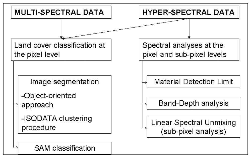
3.1. Remote sensing data
For this study, both satellite and airborne remote sensing data were processed. The main characteristics of the sensors are summarized in
Table 1.
The Earth Observing-1 (EO-1) mission is carrying three advanced technology imaging instruments. They are the Advanced Land Imager (ALI), the Hyperion hyperspectral imager, and the LAC Atmospheric Corrector.
The ALI is designed to produce images directly comparable to those of the Enhanced Thematic Mapper Plus (ETM+) of Landsat 7. It employs novel wide-angle optics and a highly integrated multispectral and panchromatic spectrometer. Operating in a push-broom fashion at an orbit of 705 km, the ALI provides Landsat type panchromatic and multispectral bands. With a partially populated focal plane, the ALI wide-angle optics produces a ground swath image width of 37 km.
The focus of the Hyperion instrument is to provide high quality calibrated data that can support evaluation of hyperspectral technology for Earth observing missions. The Hyperion is a “push broom” instrument. Each image frame taken in this push-broom configuration captures the spectrum of a line 30 m long by 7.5 km wide (perpendicular to the satellite motion). It has a single telescope and two spectrometers, one VNIR spectrometer and one SWIR spectrometer. The telescope images the Earth onto a slit that defines the instantaneous field-of-view which is 0.624° wide (i.e., 7.5 km swath width from a 705 km altitude) by 42.55 m radians (30 meters) in the satellite velocity direction. Therefore, the Hyperion provides Earth imagery at 30 m spatial resolution and with a 7.5 km swath width in 220 contiguous spectral bands at 10 nm spectral resolution. Both ALI and Hyperion data were provided at Level 1R, i.e. radiometrically corrected with no geometric correction applied. The image data are provided in 16-bit radiance values.
The Landsat Enhanced Thematic Mapper Plus (ETM+) is a sensor carried onboard the Landsat 7 satellite and has acquired images of the Earth nearly continuously since July 1999, with a 16-day repeat cycle. Landsat ETM+ image data consist of eight spectral bands with a spatial resolution of 30 meters for bands 1 to 5 and band 7. Resolution for band 6 (thermal infrared) is 60 meters and resolution for band 8 (panchromatic) is 15 meters. The data were supplied at the Level 1R (L1R) data product that provides radiometrically corrected data where calibration is applied. Image data are not geometrically corrected or geographically referenced and are provided in 16-bit (radiance) values.
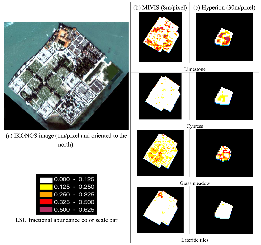
The IKONOS satellite acquires high-resolution push-broom imagery. IKONOS main characteristics are as follows: a sun synchronous orbit of 98.1 degree; an altitude of 681 Km; a resolution at Nadir of 0.82 m (panchromatic) and 3.2 m (multispectral); a ground resolution at 26° off-nadir of 1.0 m (panchromatic) and 4.0 m (multispectral); the image swath is 11.3 km at nadir and 13.8 Km at 26° off-nadir; the revisit time is approximately 3 days at 40° latitude and the dynamic range is 11-bits per pixel.
MIVIS hyperspectral sensor is a whisk-broom scanner with an axe head double mirror, it is a passive scanning and imaging instrument that is composed of 4 spectrometers which simultaneously record radiation coming from the Earth's surface. Summary specifications of MIVIS are as follows: 102 spectral bands from the VNIR to the TIR spectral range and wavelength range between 0.43-12.7 μm; an IFOV of 2 mrad and a digitized FOV of 71.1°; a numerisation (ADC) of 12 bits; scan rotational speed of 25, 16.7, 12.5, 8.3 and 6.25 scan/s; 2 reference black bodies selectable between 15°C and 45°C; a Position Attitude System composed of a GPS receiver for measuring aircraft's position (accuracy 15-20 m) and speed (accuracy 0.05-0.20 m/sec) and a gyroscope for determining aircraft's roll and pitch (accuracy ±0.2°) with a roll correction in real time between ±10°; a flux gate compass for finding aircraft's variation around the yaw axis (accuracy ±0.56°) and a computer-aided data quality check for all channels in real time.
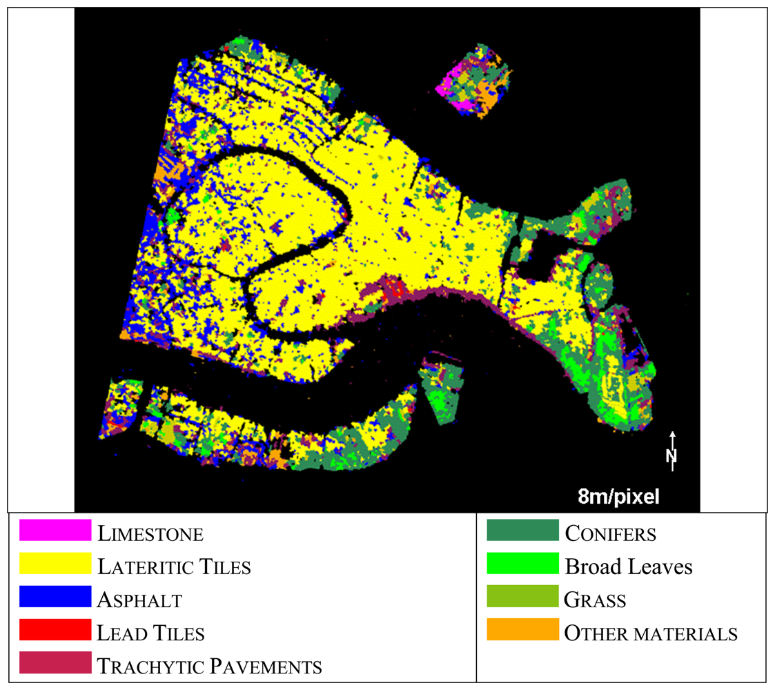
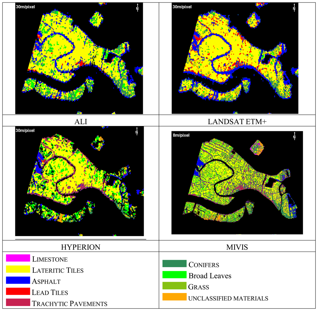
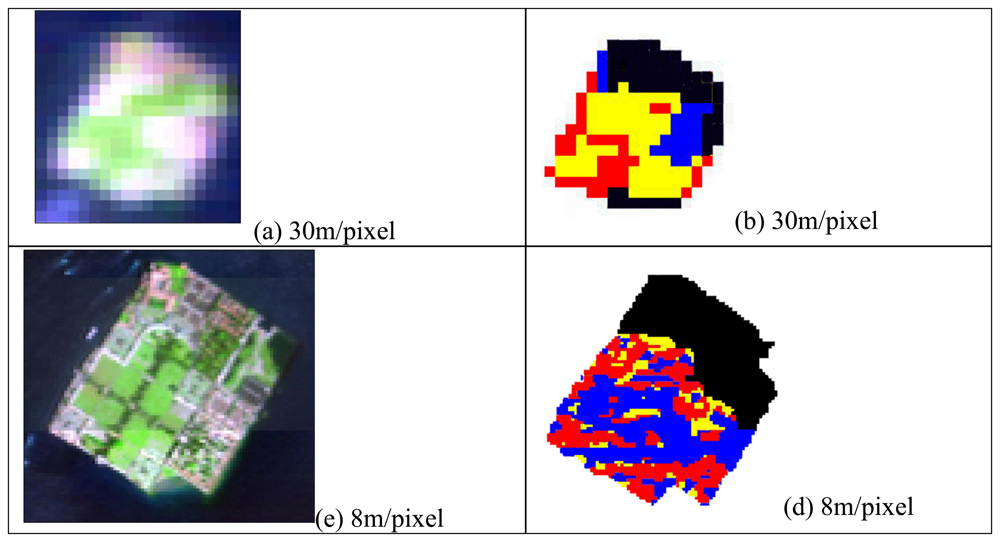
The datasets acquired over Venice city consisted of (a) MIVIS airborne data acquired on July 26, 2001 at 10:45 (GMT), using scan rates of 25 scans/s at an altitude of 4000m, corresponding to a 8-m ground-pixel resolution at the instrument's IFOV; (b) EO-1 sensors satellite data acquired on June 7, 2001 at 11:56 (GMT); (c) Landsat ETM+ satellite data acquired on July 2, 2001; and (d) IKONOS satellite data acquired on July 2001.
As ALI sensor does not cover the entire Venice city (i.e. the western part of the city was out of the swath) all sensors comparisons were referred to the ALI scene.
For this study, the high spatial resolution IKONOS imagery (1m/pixel) of the Venice city was used as ground truth.
3.2. Image pre-processing
The satellite datasets with a 30m/pixel spatial resolution (i.e., ALI, ETM+ and Hyperion) were provided radiometrically calibrated at the sensor (Level 1R). Hyperion data were also corrected by the “SMILE” distortion effect by applying the method described in Datt et al. [
11], and then processed using a global destriping procedure to reduce the spectral effects of column-to-column noise resulting from the pushbroom design [
11]. The data volume was reduced to 157 bands, encompassing the 0.427 to 2.365 mm spectral region, by excluding noisy bands and the channels of water absorption.
The satellite data were corrected by atmospheric effects by means of the FLAASH module [
29], as implemented in the ENVI 4.4. [
26] software package, which incorporates the MODTRAN4 radiation transfer code [
3]. The standard MODTRAN urban aerosol/haze type was selected [
3] for the aerosol model as the visibility for all the images was high (i.e. greater than 40 km).
As regard MIVIS airborne data, the raw data were radiometrically calibrated to radiance (nW cm
-2 sr
−1 nm
−1) using the calibration factors measured for each MIVIS channel, on the test bench, on June 2001 by the Italian CNR-LARA researchers [
4]. Atmospheric correction procedures were applied to MIVIS radiance data using the MODTRAN radiative transfer code [
3]. The MODTRAN code was used to calculate look-up tables of standard radiative functions to compute atmospheric correction (path radiance, atmospheric transmittance and solar flux) with respect to the variations in viewing and illumination angles, to the relative azimuth angle between scan lines, to the solar azimuth and terrain elevation. In the process, adjacency effects were considered using the empirical formula described in Vermote et al. [
47]. The calibration results were validated using in situ spectral measurements (vegetation, bare soil, asphalt and different roof types) collected using the ASD field spectrometer.
In order to obtain a comparable reflectance data set, the residual errors occurring in the satellite data were minimized by applying the empirical line method, as implemented in the ENVI 4.4. [
26] software package, by using the collected ground truth spectra. The empirical line calibration forces the image spectra to match reflectance spectra collected from the field. This method is capable of producing the most accurate results possible, but requires ground truth information.
The obtained reflectance values for Hyperion, ALI and LANDSAT ETM+ data sets were further geocoded in the UTM (Universal Transverse Mercator, European 1950 datum) map projection reference system, by using 30 Ground Control Points (GCPs) extracted from the Regional Technical Map at a scale of 1:10,000. An RMS error of about 0.9 pixels, accomplished in one step by means of the nearest-neighbor re-sampling algorithm, was obtained for the three sensors.
The IKONOS imagery, which was used as ground truth in this study, was geometrically corrected to the same UTM map projection as the other sensors. Moreover, in order to acquire a higher accuracy of the geocoded image, the rigorous model proposed by Toutin [
44] was applied for the geometric correction method. A root mean square error approximately of 1-2 pixels (1.5m) was attained.
The geocoding process applied to MIVIS data was different, as the airborne images of a whiskbroom sensor are affected by geometric distortions. MIVIS data were geometrically corrected by using an own code, implemented in the IDL 4.4. software package [
26], which is based on the precise trajectory reconstruction process by using onboard GPS/INS systems and additional ground control point information. In particular, MIVIS data were geocoded using (
i) the sensor trajectory (sampled at 1Hz) and the platform attitude (sampled at 25Hz) recorded on board; (
ii) the system whiskbroom geometry; (
iii) a set of GCPs, extracted from the Regional Technical Map at a scale of 1:10,000, in the navigational data processing to reduce the uncertainties in the trajectory reconstruction. MIVIS images yielded an RMS error of 0.53 pixels.
At last, it must be considered that the comparison between the classified imagery and the IKONOS ground-truth reference can be influenced by the accuracy of the pixels location (RMS error) in those areas where a mixture of urban land cover types/surface materials occurs. The IKONOS ground truth cover vectorial map was further spatially resampled according to the sensor's spatial resolution to compare the retrieved covering materials abundance values.
3.3. Field campaign
Extensive field campaigns were conducted, from June to September 2001, using the portable field spectrometer FieldSpec FR Pro (ASDI Inc., Boulder, Colorado, USA). The ASD spectrometer samples a spectral range of 350–2500 nm using one detector spanning the VNIR and two spanning the SWIR, with a spectral sampling interval of 1.4 nm and 2.0 nm respectively for the VNIR and the SWIR.
The spectral analyses in the field were conducted (i) to distinguish the urban materials spectrum shape from other materials and backgrounds, (ii) to construct a spectral library of urban materials useful for calibrating and validating the remote sensing data and (iii) to provide urban material samples for laboratory analysis.
The field ASD measurements were collected within 2 hours of solar noon sets, acquiring 4-5 measures for each target from a height of 1 m using a field of view of 25° to fulfill the target dimension. Measurements were converted to absolute reflectance using NIST, calibrated panel (Spectralon reference standard).
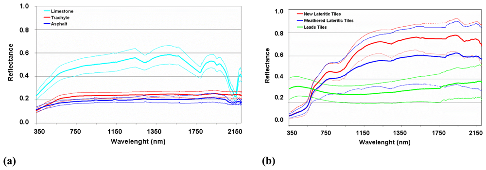
On the basis of the field campaigns, six main materials were identified in the Venice historical center (
Figure 2). They were: (a) the limestone (coming from the quarries of Pietra d'Istria, Italy) used for decoration in the urban paving; (b) the asphalt primarily used in the western site of the city and in the harbor areas; (c) the trachyte rock (coming from the quarry of the Colli Euganei, Italy) used for paving the pedestrian streets; (d,e) both new (light red color) and old (i.e., weathered and sometimes moss and lichen covered with dark red color) lateritic tiles; (f) lead tiles used as covering material for the public buildings and domes. Each urban building material was measured in different sites in order to sample the natural spectral variability (deviation standard of the collected measures) so determining a reflectance range of variability. Spectral measurements of the samples were also repeated in our laboratory for a better assessment of the spectral features of the material of interest.
The six main spectra of the material samples collected during the field campaigns are shown in
Figure 2.


