Study of the Relationships between the Spatial Extent of Surface Urban Heat Islands and Urban Characteristic Factors Based on Landsat ETM+ Data


Abstract
:
1. Introduction
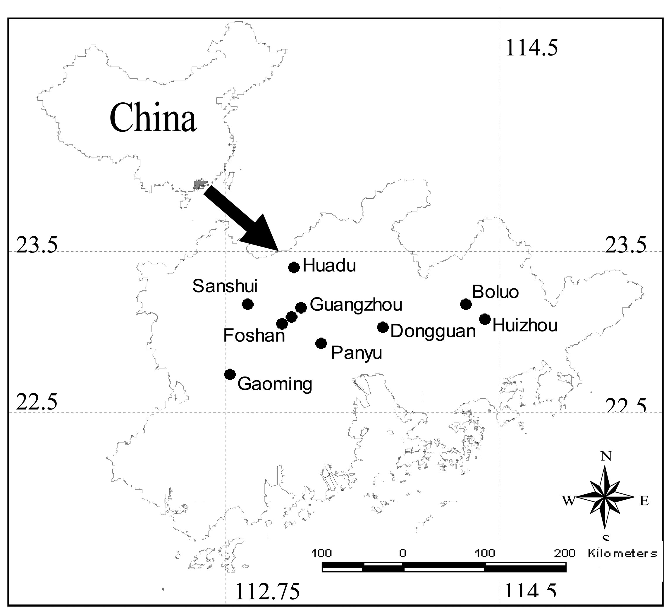
2. Study area
3. Materials and methods
3.1. Image and Pre-processing
3.2. Estimation of Vegetation Abundance
3.3. Factors Extracted from Classification Images
3.4. Estimation of Ground Surface Emissivity
3.5. Retrieving of Land Surface Temperature
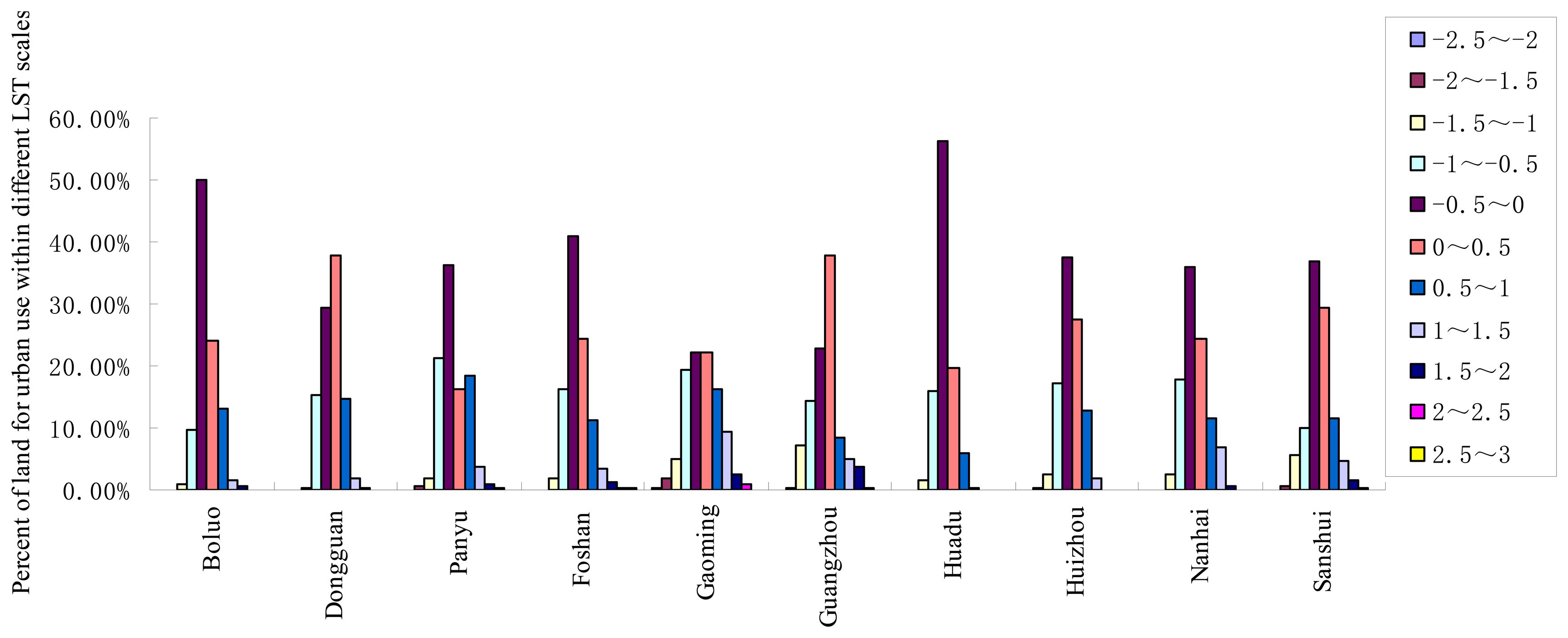
3.6. Method to Calculate The HIA
- Step 1.
- Calculate the mean surface temperatures for the cities and their standard deviation.
- Step 2.
- Use the following equation to calculate the temperature threshold values.where T stands for the temperature threshold value, a is the mean value of the surface temperature for each city, χ (χ = -2.5, -2, -1.5, -1, -0.5, 0.5, 1, 1.5, 2, 2.5, 3) is the times of standard deviation, while sd is simply the standard deviation. Here eleven values were prepared for χ and eleven temperature thresholds were calculated according to the different values of χ ranging from −2.5 to 3 by the interval of 0.5.
- Step 3.
- Divide the surface temperature into eleven scales according to the threshold values calculated in the above step.
- Step 4.
- Calculate the percentages of urban pixels in different surface temperature scales and their distribution in each city is plotted in Figure 2.
4. Results and Discussions
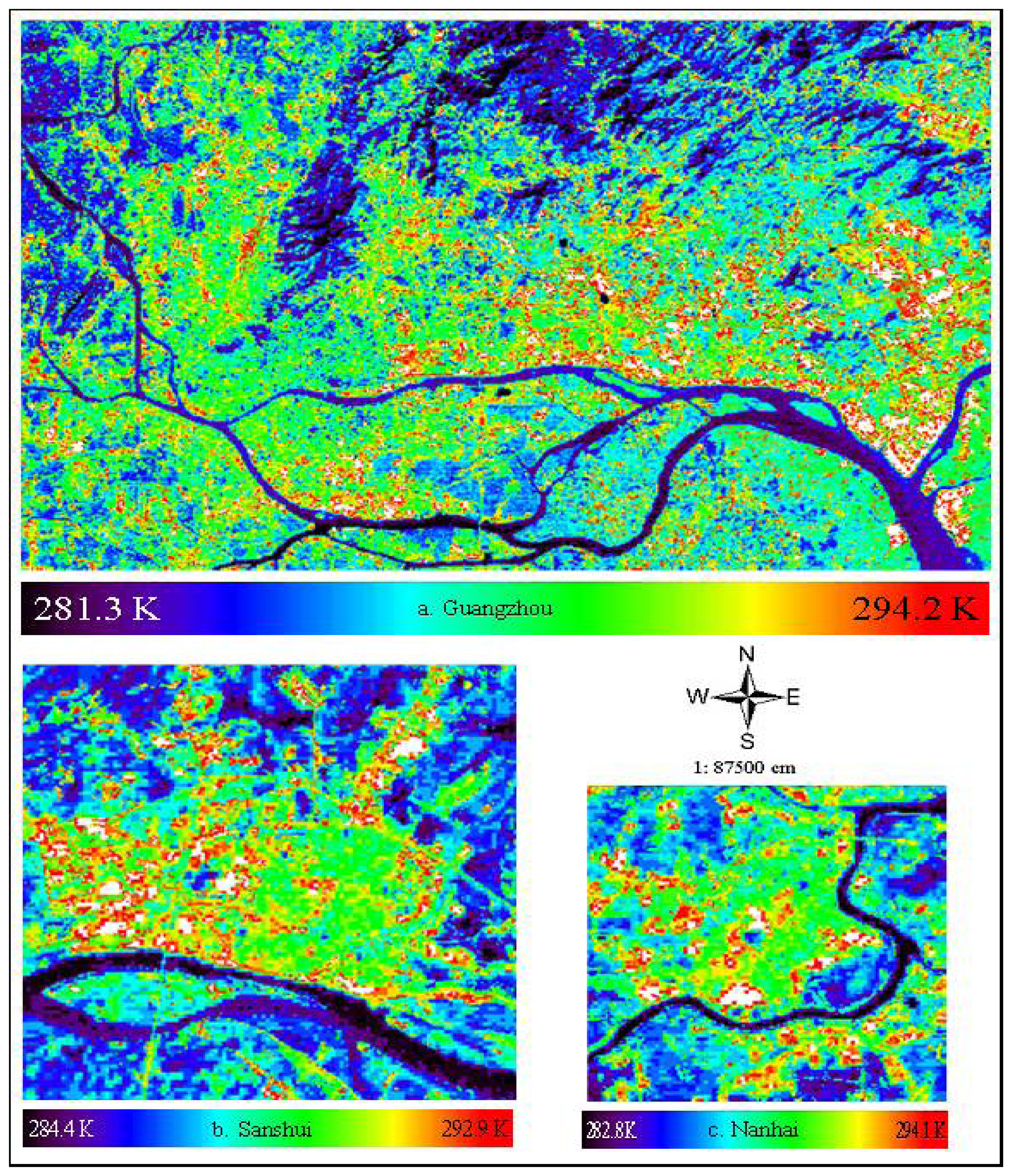
4.1. Retrieved LST of Each City and Error Analysis
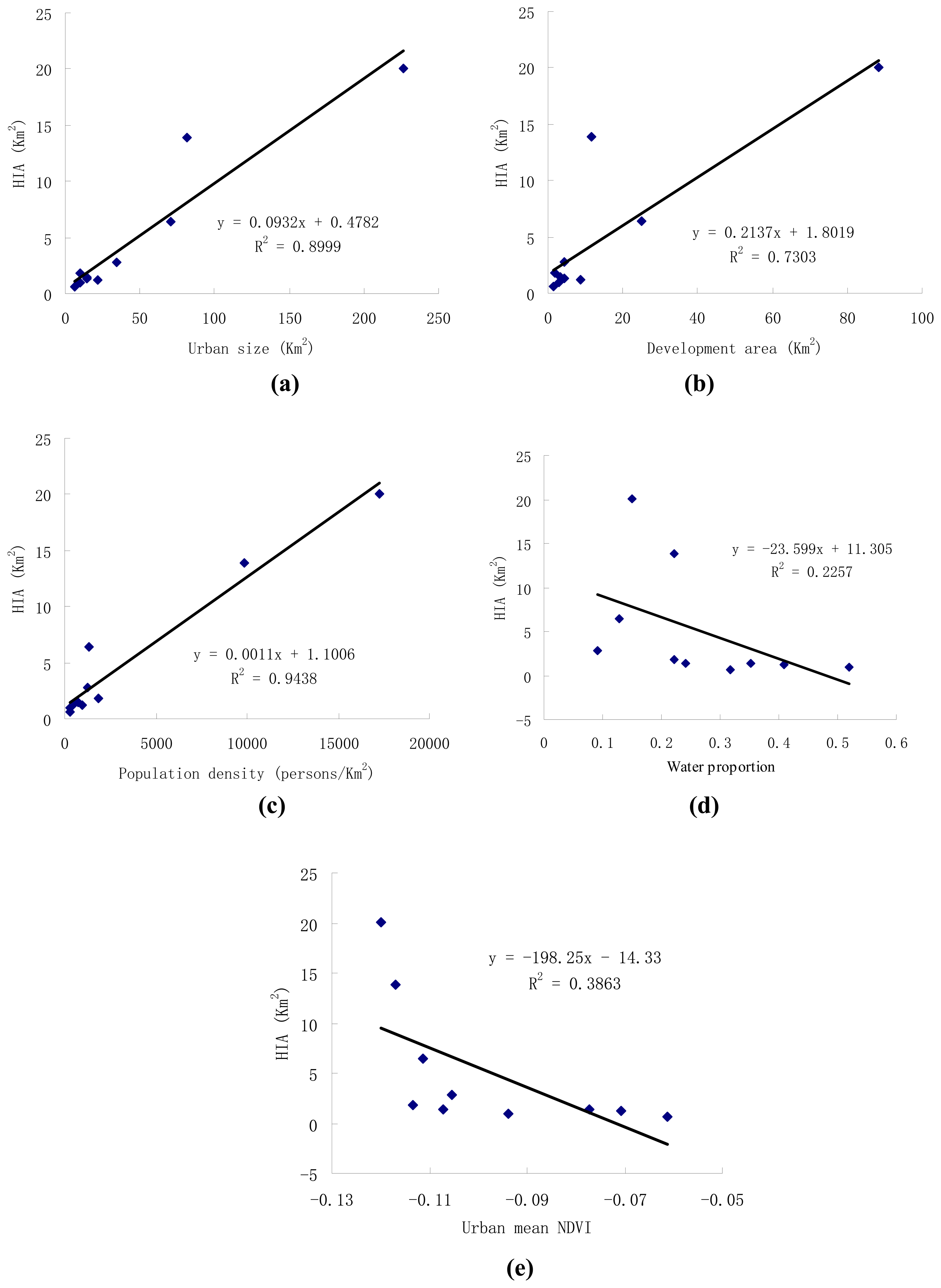
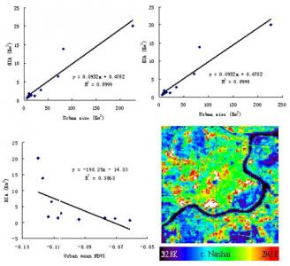
4.2. Correlation Analysis between HIA and 5 Factors
4.3. Regression Analysis between HIA and 5 Factors
5. Conclusions
Acknowledgments
References
- Oke, T.R. Technical Note No. 169: Review of Urban Climatology; World Meteorological Organization: Geneva, Switzerland, 1979; p. 43. [Google Scholar]
- Voogt, J.A.; Oke, T.R. Thermal remote sensing of urban climates. Remote Sens. Environ. 2003, 86, 370–384. [Google Scholar]
- Streutker, D.R. Satellite-measured growth of the urban heat island of Houston, Texas. Remote Sens. Environ. 2003, 85, 282–289. [Google Scholar]
- Weng, Q. Fractal analysis of satellite-detected urban heat island effect. Photogrammetric Eng. Remote Sens. 2003, 69, 555–566. [Google Scholar]
- Weng, Q.; Yang, S. Managing the adverse thermal effects of urban development in a densely populated Chinese city. J. Environ. Manage. 2004, 70, 145–156. [Google Scholar]
- Lo, C.P.; Quattrochi, D.A.; Luvall, J.C. Application of high-resolution thermal infrared remote sensing and GIS to assess the urban heat island effect. Int. J. Remote Sens. 1997, 18, 287–304. [Google Scholar]
- Friend1, M.A. Forward and inverse modeling of land surface energy balance using surface temperature measurements. Remote Sens. Environ. 2002, 79, 344–354. [Google Scholar]
- Weng, Q. A remote sensing–GIS evaluation of urban expansion and its impact on surface temperature in the Zhujiang Delta, China. Int. J. Remote Sens. 2001, 22, 1999–2014. [Google Scholar]
- Klysik, K.; Fortuniak, K. Temporal and spatial characteristics of the urban heat island of Lodz, Poland. Atmos. Environ. 1999, 33, 3885–3895. [Google Scholar]
- Chudnovsky, A.; Ben-Dor, E.; Saaroni, H. Diurnal thermal behavior of selected urban objects using remote sensing measurements. Energ. Build. 2004, 36, 1063–1074. [Google Scholar]
- Weng, Q.; Lu, D.; Schubring, J. Estimation of land surface temperature-vegetation abundance relationship for urban heat island studies. Remote Sens. Environ. 2004, 89, 467–483. [Google Scholar]
- Boegh, E.; Soegaard, H.; Hanan, N.; Kabat, P.; Lesch, L. A remote sensing study of the NDVI-Ts relationship and the transpiration from sparse vegetation in the Sahel based on high resolution satellite data. Remote Sens. Environ. 1998, 69, 224–240. [Google Scholar]
- Carson, T.N.; Gillies, R.R.; Perry, E.M. A method to make use of thermal infrared temperature and NDVI measurements to infer surface soil water content and fractional vegetation cover. Remote Sens. Environ. 1994, 9, 161–173. [Google Scholar]
- Oke, T.R. City size and the urban heat island. Atmos. Environ. 1973, 7, 769–779. [Google Scholar]
- Streutker, D.R. A remote sensing study of the urban heat island of Houston, Texas. Int. J. Remote Sens. 2002, 23, 2595–2608. [Google Scholar]
- Zhang, J.; Wang, Y. A pixel-based method to estimate urban compactness and its preliminary application. Int. J. Remote Sens. 2006, 27, 5435–5442. [Google Scholar]
- Zhang, J.; Wang, Y.; Wang, Z. Change Analysis of Land Surface Temperature Based on Robust Statistics in the Estuarine Area of Pearl River (China) from 1990 to 2000 by Landsat TM/ETM+ Data. Int. J. Remote Sens. 2007, 28, 2383–2390. [Google Scholar]
- Zhang, J.; Wang, Y.; Li, Y. A C++ program for retrieving land surface temperature from the data of Landsat TM/ETM+ band6. Comp. Geosci. 2006, 32, 1796–1805. [Google Scholar]
- García-Cueto, O.R.; Jáuregui, E.; Toudert, D.; Tejeda, A. Detection of the urban heat island in Mexicali, B.C., Mexico and its relationship with land use. Atmósphera 2007, 20, 111–132. [Google Scholar]
- Lougeay, R.; Brazel, A.; Hubble, M. Monitoring intraurban temperature patterns and associated land cover in Phoenix Arizona using Landsat Thermal Data. Geocarto Int. 1996, 11, 79–90. [Google Scholar]
- Oke, T.R. Urban climatology and the tropical city: an introduction. In Proc. of the technical conference of urban climatology and its applications with special regard to tropical areas; WMO- N° 652: Geneva, 1986; pp. 1–45. [Google Scholar]
- Guangdong Statistical Bureau. Guangdong Statistical Yearbook; China Statistics: Beijing, China, 2003. [Google Scholar]
- Hu, W.; Yang, G.; Wu, Z.; He, J. Studies on recent built-up land-cover change of urban area in the Pearl River Delta. Geogr. Res. 2003, 22, 780–788. [Google Scholar]
- Yeh, A.G.O.; Li, X. Economic development, urban sprawl and agricultural land loss in the Pearl River Delta, China. Eco. Geogr. 1999, 19, 68–72. [Google Scholar]
- Fan, F.; Weng, Q.; Wang, Y. Land Use and Land Cover Change in Guangzhou, China, from 1998 to 2003, Based on Landsat TM/ETM+ Imagery. Sensors 2007, 7, 1323–1342. [Google Scholar]
- Li, X.; Yeh, A.G.O. Application of remote sensing for monitoring and analysis of urban expansion-a case study of Dongguan. Geogr. Res. 1997, 16, 56–62. [Google Scholar]
- Li, X.; Yeh, A.G.O. Analyzing spatial restructuring of land use patterns in a fast growing region using remote sensing and GIS. Landscape Urban Plan 2004, 69, 335–354. [Google Scholar]
- Fung, T.; Siu, W. Environmental quality and its changes, and analysis using NDVI. Int. J. Remote Sens. 2000, 21, 1011–1024. [Google Scholar]
- Gallo, K.P.; Tarpley, J.D. The comparison of vegetation index and surface temperature composites of urban heat-island analysis. Int. J. Remote Sens. 1996, 17, 3071–3076. [Google Scholar]
- Huete, A.R. A soil-adjusted vegetation index (SAVI). Remote Sens. Environ. 1988, 25, 295–309. [Google Scholar]
- Dozier, J.; Warren, S.G. Effect of viewing angle on the infrared brightness temperature of snow. Water Resour. Res. 1982, 18, 1424–1434. [Google Scholar]
- Gillespie, A.R.; Rokugawa, S.; Matsunaga, T.; Cothern, J.S.; Hook, S.J.; Kahle, A.B. A temperature and emissivity separation algorithm for advanced spaceborne thermal emission and reflection radiometer (ASTER) images. IEEE Trans. Geosci. Remote Sens. 1998, 36, 1113–1126. [Google Scholar]
- Watson, K. Spectral ratio method for measuring emissivity. Remote Sens. Environ. 1992, 42, 113–116. [Google Scholar]
- Snyder, W.C.; Wan, Z.; Zhang, Y.; Feng, Y.Z. Classification-based emissivity for land surface temperature measurement from space. Int. J. Remote Sens. 1998, 19, 2753–2774. [Google Scholar]
- Van de Griend, A.A.; Owe, M. On the relationship between thermal emissivity and the normalized different vegetation index for natural surfaces. International Journal of Remote Sensing 1993, 14, 1119–1131. [Google Scholar]
- Valor, E.; Caselles, V. Mapping land surface emissivity from NDVI: Application to European, African, and South American reas. Remote Sens. Environ. 1996, 57, 167–184. [Google Scholar]
- Landsat Project Science Office. Landsat 7 science data user's handbook.; Goddard Space Flight Center; US, 2002. [Google Scholar]
- Qin, Z.; Karnieli, A.; Berliner, P. A mono-algorithm for retrieving land surface temperature from Landsat TM data and its application to the Israel-Egypt border region. Int. J. Remote Sens. 2001, 18, 583–594. [Google Scholar]
- Qin, Z.; Li, W.; Zhang, M.; Karnieli, A.; Berliner, P. Estimation of the essential atmospheric parameters of mono-window algorithm for land surface temperature retrieval from Landsat TM6. Remote Sens. Land Res. 2003, 2, 37–43. [Google Scholar]

| City name | Population density (Persons / km2) | Urban size (Km2) | Urban mean NDVI value | Water proportion | Development area (Km2) |
|---|---|---|---|---|---|
| Boluo | 270 | 6.01 | -0.0613 | 0.3167 | 2.37 |
| Dongguan | 1326 | 71.10 | -0.1115 | 0.1283 | 25.07 |
| Panyu | 1242 | 24.67 | -0.1054 | 0.0920 | 4.38 |
| Foshan | 9815 | 81.75 | -0.1168 | 0.2207 | 8.14 |
| Gaoming | 315 | 9.60 | -0.0937 | 0.6614 | 3.08 |
| Guangzho | 17282 | 226.76 | -0.1089 | 0.1507 | 88.28 |
| Huadu | 742 | 16.23 | -0.1072 | 0.2422 | 3.22 |
| Huizhou | 955 | 21.40 | -0.0707 | 0.4090 | 8.79 |
| Nanhai | 1854 | 10.49 | -0.1134 | 0.2210 | 0.91 |
| Sanshui | 542 | 14.58 | -0.0773 | 0.3514 | 4.20 |
| City name | Minimum temperature (K) | Maximum temperature (K) | Mean temperature (K) | Standard deviation | Variance | HIA (Km2) |
|---|---|---|---|---|---|---|
| Boluo | 283.3 | 292.6 | 288.9 | 0.974 | 0.948 | 0.58 |
| Dongguan | 284.2 | 294 | 289.1 | 1.303 | 1.699 | 6.46 |
| Panyu | 283.1 | 294.8 | 288.8 | 1.564 | 2.447 | 2.77 |
| Foshan | 281.7 | 294.1 | 288.4 | 1.687 | 2.845 | 13.91 |
| Gaoming | 284.7 | 292.6 | 288.0 | 1.255 | 1.575 | 1.00 |
| Guangzhou | 281.3 | 294.2 | 288.4 | 1.454 | 2.115 | 20.05 |
| Huadu | 282.5 | 291.7 | 287.8 | 1.145 | 1.312 | 1.44 |
| Huizhou | 283.2 | 292.4 | 288.3 | 1.159 | 1.344 | 1.18 |
| Nanhai Sanshui | 282.8 284.4 | 294.1 292.9 | 289.0 288.2 | 1.654 1.371 | 2.737 1.881 | 1.76 1.32 |
| Factors | Coefficient of correlation with HIA | P-value for T-test |
|---|---|---|
| Urban size | 0.950 | 0.000 |
| Population density | 0.971 | 0.000 |
| Water proportion | -0.418 | 0.206 |
| Urban mean NDVI value | -0.515 | 0.128 |
| Development area | 0.833 | 0.003 |
© 2008 by the authors; licensee MDPI, Basel, Switzerland. This article is an open access article distributed under the terms and conditions of the Creative Commons Attribution license (http://creativecommons.org/licenses/by/3.0/).
Share and Cite
Zhang, J.; Wang, Y. Study of the Relationships between the Spatial Extent of Surface Urban Heat Islands and Urban Characteristic Factors Based on Landsat ETM+ Data. Sensors 2008, 8, 7453-7468. https://doi.org/10.3390/s8117453
Zhang J, Wang Y. Study of the Relationships between the Spatial Extent of Surface Urban Heat Islands and Urban Characteristic Factors Based on Landsat ETM+ Data. Sensors. 2008; 8(11):7453-7468. https://doi.org/10.3390/s8117453
Chicago/Turabian StyleZhang, Jinqu, and Yunpeng Wang. 2008. "Study of the Relationships between the Spatial Extent of Surface Urban Heat Islands and Urban Characteristic Factors Based on Landsat ETM+ Data" Sensors 8, no. 11: 7453-7468. https://doi.org/10.3390/s8117453
APA StyleZhang, J., & Wang, Y. (2008). Study of the Relationships between the Spatial Extent of Surface Urban Heat Islands and Urban Characteristic Factors Based on Landsat ETM+ Data. Sensors, 8(11), 7453-7468. https://doi.org/10.3390/s8117453