Land Use and Land Cover Change in Guangzhou, China, from 1998 to 2003, Based on Landsat TM /ETM+ Imagery


Abstract
:1. Introduction
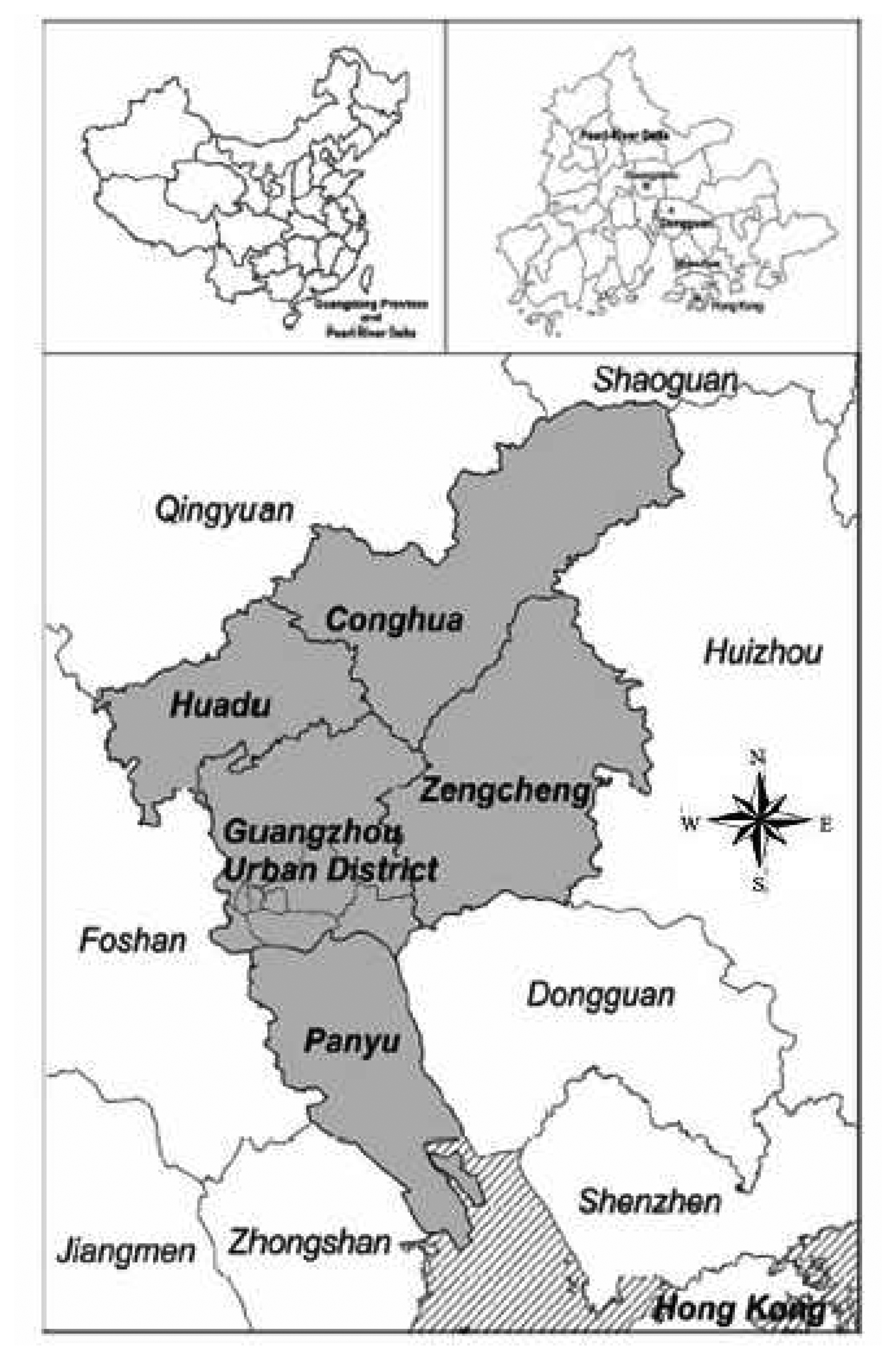
2. Study area
3. Methodology
3.1 Data
3.2 Image classification and accuracy assessment
3.3 Post-classification change detection
4. Results
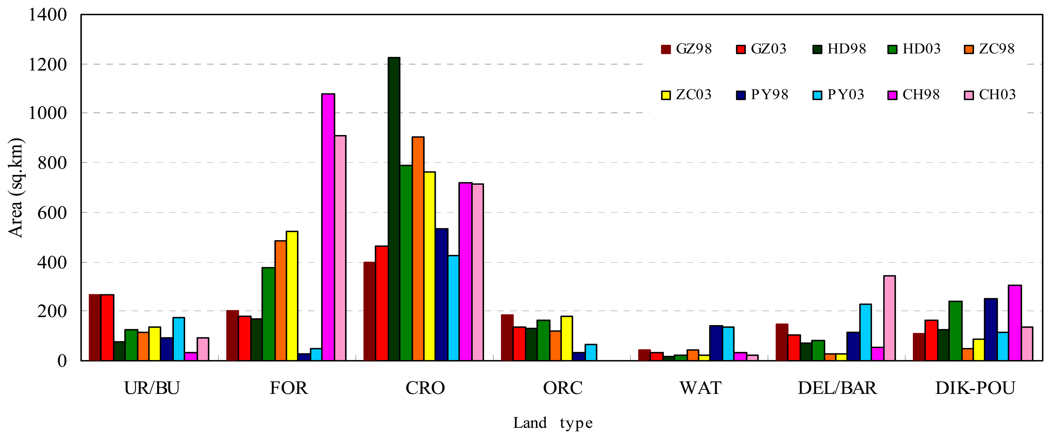
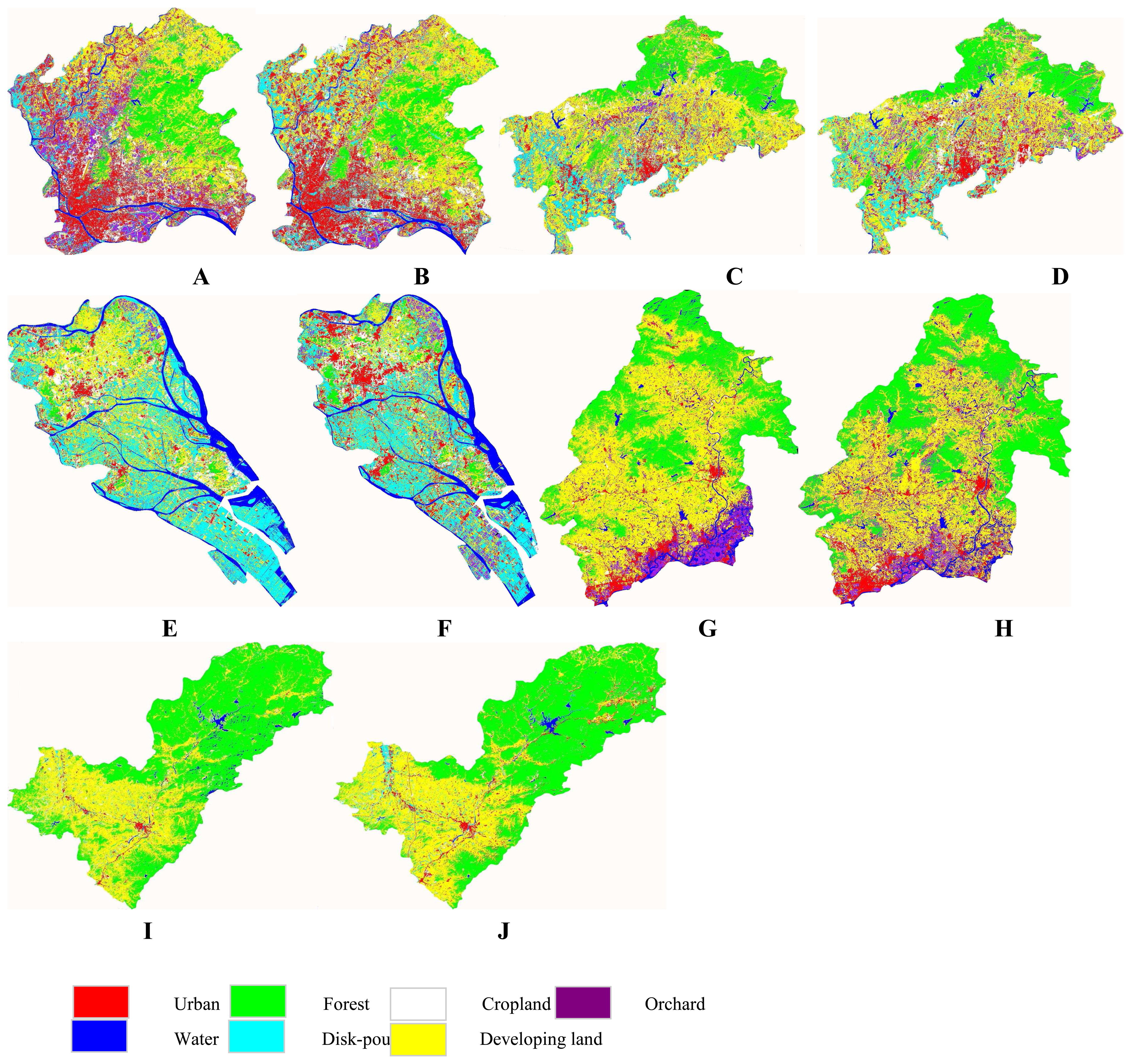
4.1 LULC patterns in 1998 and 2003
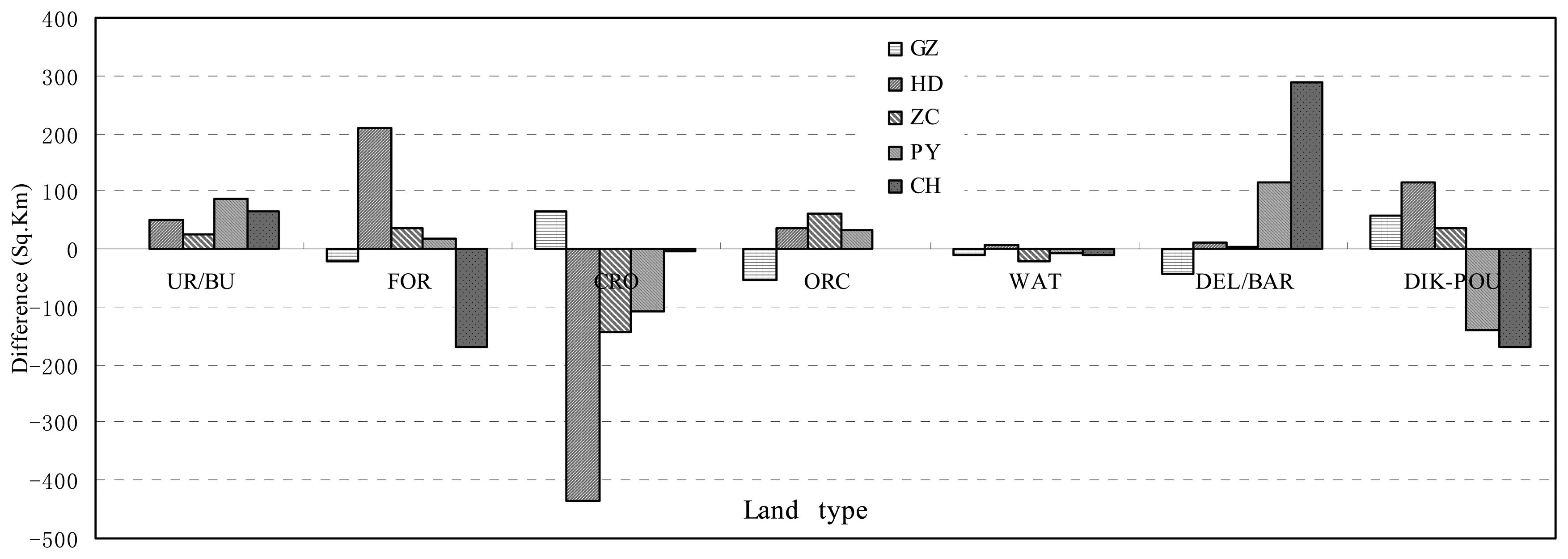
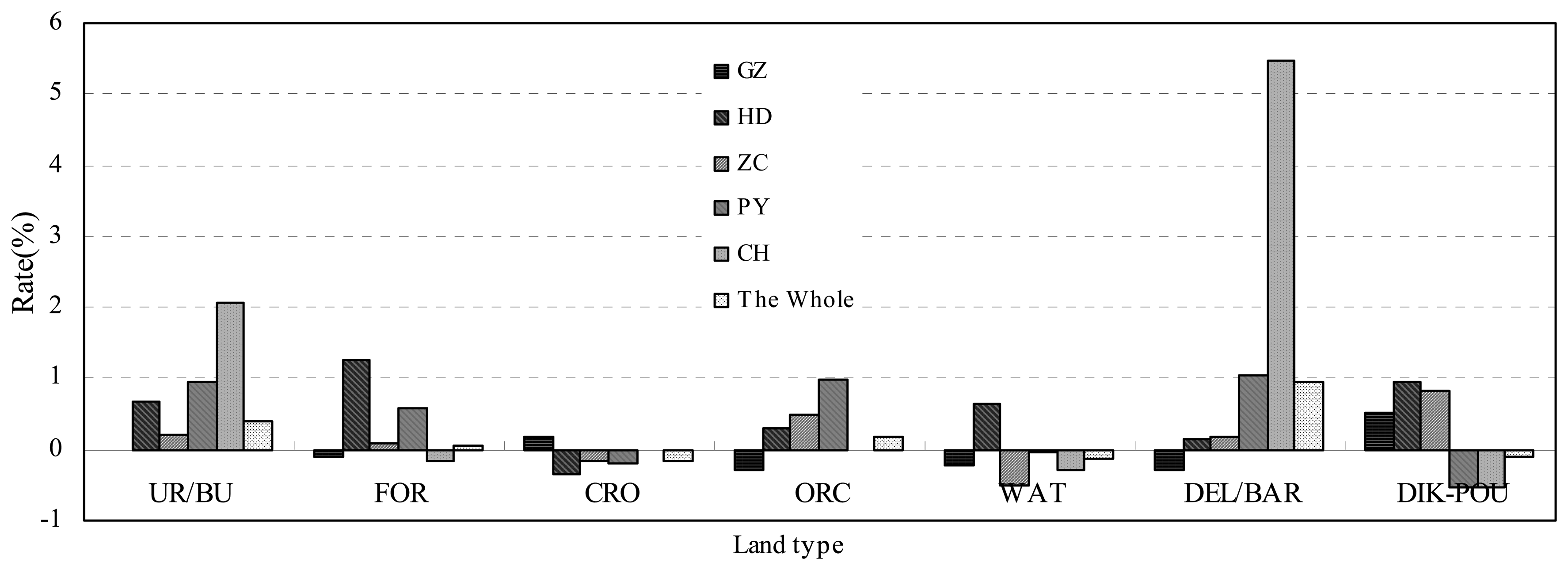
4.2 LULC changes of five counties from 1998 to 2003
4.3 Urban expansion of five counties in 1998-2003
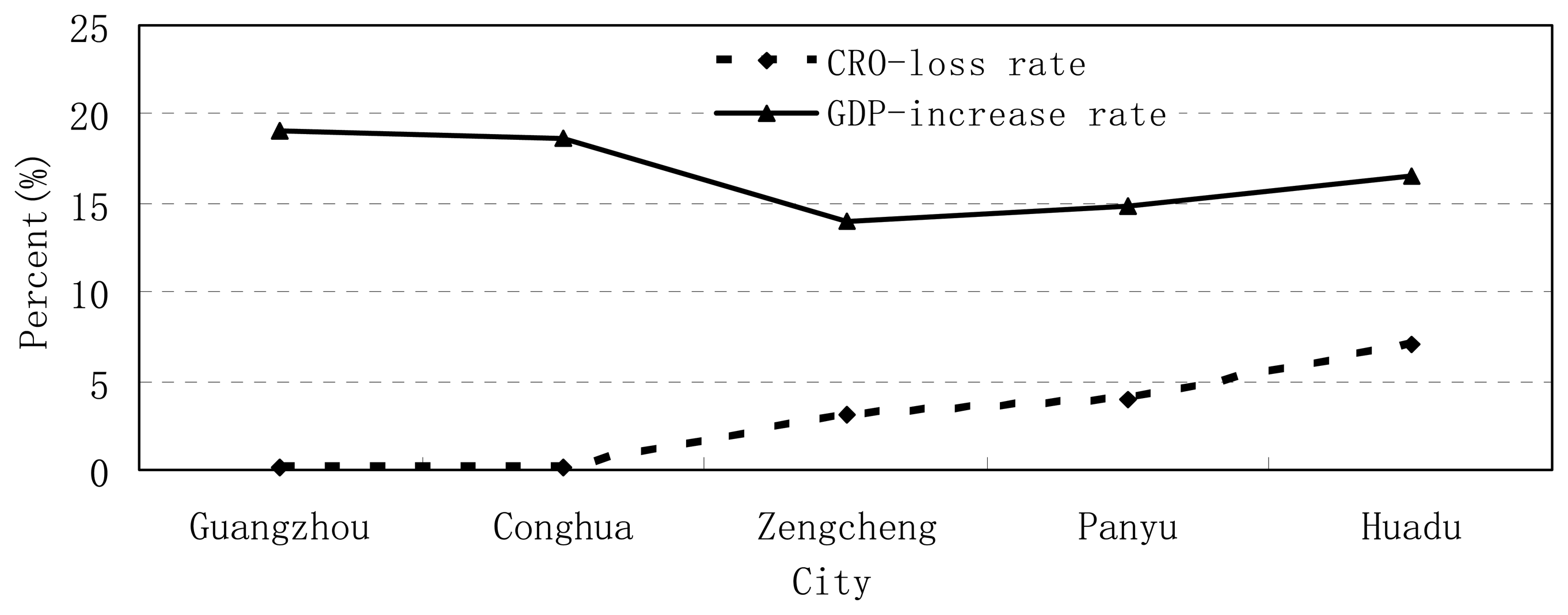
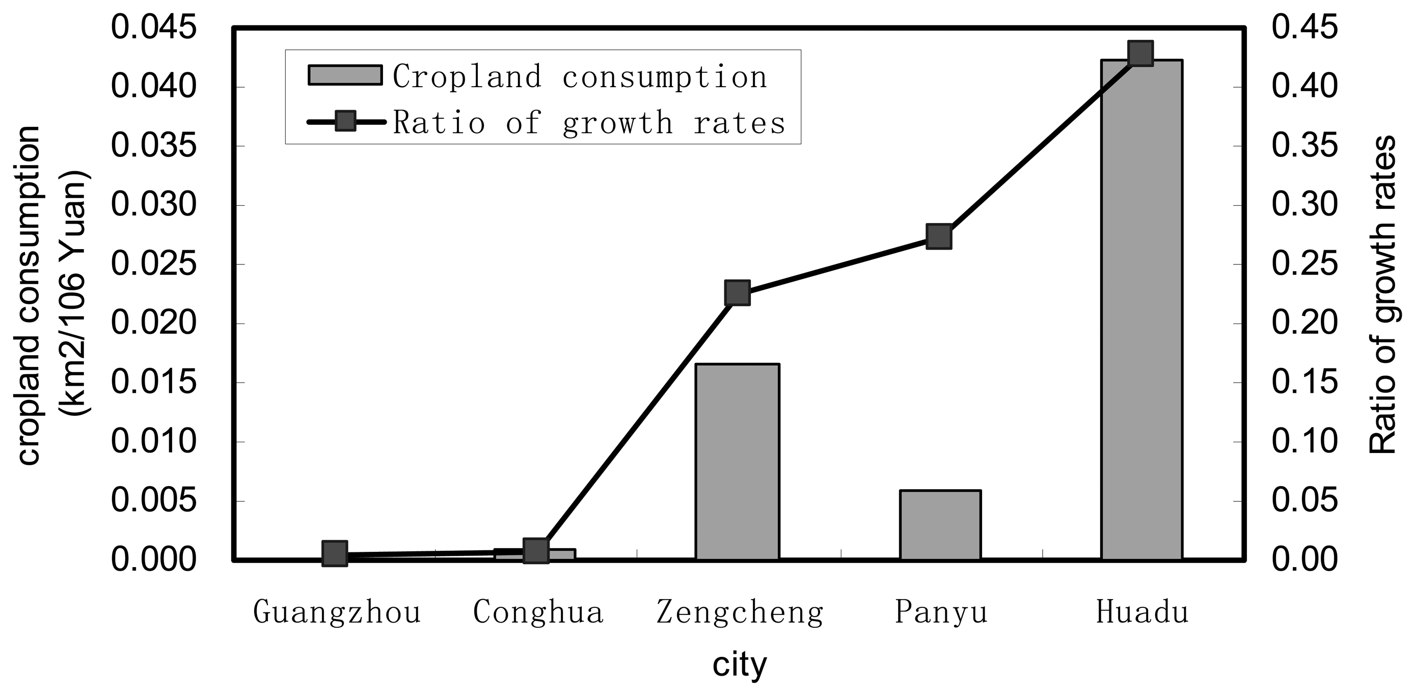
4.4 Cropland loss of five counties in 1998-2003
4.5 Urban expansion and cropland loss of Guangzhou Municipality in 1998-2003
5. Conclusions
Acknowledgments
References
- Cho, S.H. Digital change detection by post-classification comparison of multi-temporal remotely sensed data. Journal of the Korean Society of Remote Sensing 1999, 16(4), 367–373. [Google Scholar]
- Collins, J.B.; Woodcoch, C. E. Change detection using the Gramm-Schmidt transformation applied to mapping forest mortality. Remote Sensing of Environment 1994, 50, 267–279. [Google Scholar]
- Collins, J.B.; Woodcoch, C. E. An assessment of several linear change detection techniques for mapping forest mortality using multitemporal Landsat TM data. Remote Sensing of Environment 1996, 56, 66–77. [Google Scholar]
- Congalton, R. G. A review of assessing the accuracy of classification of remotely sensed data. Remote Sensing of Environment 1991, 37, 35–46. [Google Scholar]
- Dai, X. L.; Khorram, S. Remotely sensed change detection base on artificial neural networks. Photogrammetric Engineering and Remote Sensing 1999, 65, 1187–1194. [Google Scholar]
- Eastrman, J.R.; Fulk, M. Long sequence time series evaluation using standardized principle components. Photogrammertric Engineering and Remote Sensing 1993, 59, 991–996. [Google Scholar]
- Ehlers, M.; Jadkowski, M. A.; Howard, R. R.; Brostuen, D. E. Application of SPOT data for regional growth analysis and local planning. Photogrammertric Engineering and Remote Sensing 1990, 56, 175–180. [Google Scholar]
- Fung, T.; LeDrew, E. Application of principal components analysis change detection. Photogrammetric Engineering Remote Sensing 1987, 53(12), 1649–1658. [Google Scholar]
- Fung, T. An assessment of TM imagery for land-cover change detection. IEEE Trans. Geosci. Rem. Sen. 1990, 28, 681–684. [Google Scholar]
- Foody, G.M. On the compensation for chance agreement in image classification accuracy assessment. Photogrammetric Engineering Remote Sensing 1992, 58(10), 1459–1460. [Google Scholar]
- Foody, G.M. Monitoring the magnitude of land cover change around the Southern Limits of the Sahara. Photogrammetric Engineering Remote Sensing 2001, 67(7), 841–847. [Google Scholar]
- Foody, G.M. Status of land cover classification accuracy assessment. Remote sensing of Environment 2002, 80, 185–201. [Google Scholar]
- Gopal, S.; Woodcock, C. E. Remote sensing of forest change using artificial neural networks. IEEE Trans. Geosci. Rem. Sen 1996, 34, 398–404. [Google Scholar]
- Guangdong Statistical Bureau. Guangdong statistical yearbook.; Beijing; China Statistics Press, 1998 2004; in Chinese.
- Harries, P. M.; Ventura, S. J. The integration of geographic data with remotely sensed imagery to improve classification in an urban area. Photogrammertric Engineering and Remote Sensing 1995, 61, 381–385. [Google Scholar]
- Hord, R.M.; Brooner, W. Land use map accuracy criteria. Photogrammertric Engineering and Remote Sensing 1976, 42, 671–677. [Google Scholar]
- Houghton, R.A. The worldwide extent of land-use change. Bioscience 1994, 44(5), 305–313. [Google Scholar]
- Howarth, P. J. Landsat digital enhancements for change detection in urban environment. Remote Sensing of Environment 1986, 13, 149–160. [Google Scholar]
- Jensen, J.R. Urban change detection mapping using Landsat digital data. The American Cartographer 1981, 8(2), 127–147. [Google Scholar]
- Jensen, J.R. Introductory digital image processing: a remote sensing perspective, Second Edition. ed; Prentice Hall, 1996; p. 316p. [Google Scholar]
- Kaufmann, R.K.; Seto, K.C. Change detection, accuracy, and bias in a sequential analysis of Landsat imagery in the Pearl River Delta China: econometric techniques. Agriculture Ecosystems & Environment 2001, 85, 95–105. [Google Scholar]
- Lambin, E. F.; Strhler, A. H. Change-vector analysis in multi-temporal space: a tool to detect and categorize land-cover change processes suing high temporal-resolution satellite date. Remote Sensing of Environment 1994, 48, 231–244. [Google Scholar]
- Lambin, E. F. Modeling and monitoring land-cover change processes in tropical regions. Prog. Phys. Geog 1997, 21(3), 375–393. [Google Scholar]
- Li, X. A method to improve classification with shape information. International Journal of Remote Sensing 1996, 17, 1473–1481. [Google Scholar]
- Li, X. Measurement of rapid agriculture land loss in the Pearl River Delta with the integration of remote sensing and GIS. Environment and Planning B 1998, 25, 447–461. [Google Scholar]
- Li, X.; Yeh, A.G.O. Principal component analysis of stacked multi-temporal images for monitoring of rapid urban expansion in the Pearl River Delta. International Journal of Remote Sensing 1998, 19(8), 1501–1518. [Google Scholar]
- Li, X.; Yeh, A.G.O. Analyzing spatial restructuring of land use patterns in a fast growing region using remote sensing and GIS. Landscape and Urban Planning 2004, 69(4), 335–354. [Google Scholar]
- Lopez, E.; Bocco, G. Predicting land-cover and land use change in the urban fringe a case in Morelia city, Mexico. Landscape and urban planning 2001, 55, 271–285. [Google Scholar]
- Mas, J. F. Monitoring land-cover changes: a comparison of change detection techniques. International Journal of Remote Sensing 1999, 20(1), 139–152. [Google Scholar]
- Pal, M.; Mather, P.M. An assessment of the effectiveness of decision tree methods for land cover classification. Remote sensing of environment 2003, 86, 554–565. [Google Scholar]
- Prenzel, B. Remote sensing-based quantification of land-cover and land use change for planning. Progress in planning 2004, 61, 281–299. [Google Scholar]
- Ridd, M.K.; Liu, J.J. A comparison of four algorithms for change detection in an urban environment. Remote sensing of environment 1998, 63, 95–100. [Google Scholar]
- Rosenfield, G. H.; Fitzpatrick-Lins, K. A coefficient of agreement as a measure of thematic classification accuracy. Photogrammetric Engineering and Remote Sensing 1986, 52, 223–227. [Google Scholar]
- Schneider, A.; Seto, K.C.; Webster, D.; Cai, J.; Luo, B. Spatial and temporal patterns of urban dynamics in Chengdu 2002-2003, ISBN: 1-931368-03-1. 1975.
- Seto, K.C.; Woodcock, C. E. Monitoring land use change in the Pearl River Delta using Landsat TM. International Journal of Remote sensing 2002, 23(10), 1985–2004. [Google Scholar]
- Seto, K.C.; Kaufmann, R.K.; Woodcock, C.E. Landsat reveal china's farmland reserves, but they're vanishing fast. Nature 2000, 406(13), 121. [Google Scholar]
- Seto, K.C.; Kaufmann, R.K. Modeling the drivers of urban land use change in the Pearl River Delta, China: integrating remote sensing with socioeconomic data. Land. Econ. 2003, 79, 106–121. [Google Scholar]
- Singh, A. Digital change detection techniques using remotely sensed data. International Journal of Remote Sensing 1989, 10(6), 989–1003. [Google Scholar]
- Smit, B.E.; Cocklin, C. Future urban growth and agricultural land: alternatives for Ontario. Ontario Geogr. 1981, 18, 47–55. [Google Scholar]
- Treitz, P.M.; Howard, P. J.; Gong, P. Application of satellite and GIS technologies for land-cover and land use mapping at the rural-urban fringe: a case study. Photogrammertric Engineering and Remote Sensing 1992, 58, 439–448. [Google Scholar]
- Weng, Q. Human-environment interactions in agricultural land use in a South China's wetland region: a study on the Zhujiang Delta in the Holocene. GeoJournal 2000, 51(3), 191–202. [Google Scholar]
- Weng, Q. A remote sensing-GIS evaluation of urban expansion and its impact on surface temperature in the Zhujiang Delta, China. International Journal of Remote Sensing 2001, 22(10), 1999–2014. [Google Scholar]
- Weng, Q. Land use change analysis in the Zhujiang Delta of China using satellite remote sensing, GIS, and stochastic modeling. Journal of Environmental Management 2002, 64, 273–284. [Google Scholar]
- Weng, Q.; Qiao, L.; Yang, S.; Guo, H. Guangzhou's growth and urban planning, 1960-1997 an analysis through remote sensing. Asian Geographer 2003, 22(1-2), 77–92. [Google Scholar]
- Xu, H.; Wang, X.; Xiao, G. A remote sensing and GIS integrated study on urbanization with its impact on arable lands: Fuqing city, Fujian Province, China. Land Degradation and Development 2000, 11, 301–314. [Google Scholar]
- Xu, X.Q.; Li, S.M. China's open door policy and urbanization in the Pearl River Delta Region. International Journal of Urban and Regional Research 1990, 14(1), 49–69. [Google Scholar]
- Yang, X.; Lo, C.P. Using a time series of satellite imagery to detect land use and land cover changes in the Atlanta, Georgia Metropolitan Area. International Journal of Remote Sensing 2002, 23, 1775–1798. [Google Scholar]
- Yeh, A.G.O.; Li, X. Economic development and agricultural land loss in the Pearl River Delta, China. Habitat International 1999, 23(3), 373–390. [Google Scholar]
- Yeh, A.G.O.; Li, X. Sustainable land development model for rapid growth areas using GIS. International Journal of Geographical Information Science 1998, 12(2), 169–189. [Google Scholar]


| Land type | URB | FOR | WAT | DIS | CRO | ORC | DEV |
|---|---|---|---|---|---|---|---|
| Classification accuracy of 1998 | 94.2% | 86.4% | 89.9% | 76.5% | 78.5% | 72.6% | 73.1% |
| Classification accuracy of 2003 | 96.2% | 90.1% | 89.7% | 77.4% | 85.2% | 76.1% | 74.9% |
| URB | FOR | CRO | ORC | WAT | DEL | DIK | 1998 | |
|---|---|---|---|---|---|---|---|---|
| URB | 151.12 | 0.86 | 36.64 | 13.06 | 1.34 | 21.68 | 40.92 | 265.76 |
| FOR | 1.33 | 127.15 | 59.57 | 8.93 | 0.01 | 2.36 | 1.36 | 201.14 |
| CRO | 21.36 | 40.27 | 234.40 | 50.02 | 0.44 | 26.96 | 24.19 | 398.09 |
| ORC | 19.36 | 7.91 | 80.46 | 41.71 | 0.44 | 13.72 | 23.21 | 186.98 |
| WAT | 1.67 | 1.20 | 2.05 | 1.07 | 26.01 | 0.71 | 10.15 | 42.96 |
| DEL | 53.66 | 1.37 | 28.82 | 8.25 | 0.74 | 30.82 | 21.43 | 145.20 |
| DIK | 18.14 | 1.82 | 21.95 | 11.79 | 4.00 | 6.76 | 43.94 | 108.52 |
| 2003 | 266.80 | 180.70 | 464.09 | 134.93 | 33.44 | 103.10 | 165.61 | 1348.65 |
| URB | FOR | CRO | ORC | WAT | DEL | DIK | 1998 | |
|---|---|---|---|---|---|---|---|---|
| URB | 26.47 | 0.38 | 24.99 | 5.20 | 0.22 | 6.44 | 10.54 | 74.30 |
| FOR | 0.51 | 128.62 | 29.92 | 5.92 | 0.32 | 0.58 | 1.67 | 167.67 |
| CRO | 72.88 | 227.24 | 589.94 | 116.46 | 12.62 | 53.245 | 152.44 | 1225.17 |
| ORC | 7.88 | 15.69 | 70.55 | 17.76 | 0.20 | 4.21 | 11.66 | 128.12 |
| WAT | 0.85 | 0.13 | 2.17 | 0.67 | 6.28 | 0.90 | 2.94 | 14.11 |
| DEL | 6.11 | 2.78 | 34.34 | 8.00 | 0.20 | 9.96 | 7.55 | 68.63 |
| DIK | 9.01 | 3.21 | 39.32 | 11.32 | 3.14 | 4.21 | 52.00 | 122.61 |
| 2003 | 123.72 | 378.05 | 791.23 | 164.93 | 22.99 | 79.55 | 238.80 | 1799.26 |
| URB | FOR | CRO | ORC | WAT | DEL | DIK | 1998 | |
|---|---|---|---|---|---|---|---|---|
| URB | 15.30 | 0.48 | 10.42 | 0.14 | 2.10 | 2.71 | 31.16 | |
| FOR | 19.39 | 803.58 | 144.24 | 0.82 | 99.36 | 11.24 | 1079.74 | |
| CRO | 48.22 | 77.51 | 513.56 | 1.88 | 38.43 | 39.83 | 719.59 | |
| ORC | ||||||||
| WAT | 0.88 | 13.48 | 0.97 | 1.48 | 10.68 | 5.34 | 32.83 | |
| DEL | 5.67 | 10.58 | 21.86 | 2.38 | 3.29 | 8.94 | 52.72 | |
| DIK | 5.70 | 3.51 | 23.21 | 16.69 | 187.78 | 70.60 | 307.49 | |
| 2003 | 95.18 | 910.09 | 714.64 | 23.39 | 341.64 | 138.66 | 2223.6 |
| URB | FOR | CRO | ORC | WAT | DEL | DIK | 1998 | |
|---|---|---|---|---|---|---|---|---|
| URB | 54.32 | 4.17 | 28.79 | 9.17 | 1.54 | 2.91 | 10.80 | 111.78 |
| FOR | 4.66 | 368.31 | 77.31 | 28.51 | 0.20 | 4.62 | 2.58 | 486.74 |
| CRO | 50.13 | 134.36 | 570.49 | 99.94 | 2.00 | 15.38 | 31.52 | 904.02 |
| ORC | 13.18 | 6.61 | 53.63 | 35.41 | 0.47 | 2.04 | 9.83 | 121.31 |
| WAT | 2.38 | 8.55 | 6.20 | 1.65 | 13.09 | 0.53 | 10.69 | 43.28 |
| DEL | 6.12 | 1.15 | 11.68 | 0.98 | 0.39 | 3.19 | 1.50 | 25.02 |
| DIK | 5.38 | 0.65 | 12.62 | 5.92 | 3.36 | 0.75 | 17.68 | 46.46 |
| 2003 | 136.24 | 524.72 | 760.89 | 181.62 | 21.11 | 29.45 | 84.65 | 1738.68 |
| URB | FOR | CRO | ORC | WAT | DEL | DIK | 1998 | |
|---|---|---|---|---|---|---|---|---|
| URB | 47.88 | 1.28 | 20.75 | 1.63 | 0.34 | 10.21 | 7.81 | 89.96 |
| FOR | 0.78 | 17.91 | 5.99 | 2.13 | 0.01 | 1.41 | 1.27 | 29.49 |
| CRO | 57.99 | 19.4 | 303.47 | 45.49 | 0.60 | 54.33 | 52.65 | 534.18 |
| ORC | 1.78 | 3.53 | 14.9 | 9.05 | 0.03 | 1.75 | 1.61 | 32.66 |
| WAT | 1.63 | 0.09 | 0.86 | 0.05 | 113.86 | 21.70 | 1.99 | 141.61 |
| DEL | 36.60 | 0.94 | 28.19 | 1.30 | 0.24 | 7.69 | 37.34 | 112.36 |
| DIK | 29.53 | 3.52 | 52.15 | 4.79 | 18.60 | 131.92 | 11.14 | 252.14 |
| 2003 | 176.33 | 46.68 | 426.57 | 64.49 | 134.93 | 229.55 | 113.88 | 1192.43 |
| Year | 1997 | 1998 | 1999 | 2000 | 2001 | 2002 | 2003 |
|---|---|---|---|---|---|---|---|
| GDP | 164625.67 | 184160.52 | 205673.83 | 237591.29 | 271390.79 | 300147.6 | 349687.87 |
| Rates of GDP growth | 11.87% | 11.68% | 15.52% | 15.79% | 10.59% | 16.51% |
| Regions | Guangzhou | Zengcheng | Panyu | Conghua | Huadu | Whole Guangzhou |
|---|---|---|---|---|---|---|
| Cropland loss(km2) | 1.0377 | 143.13333 | 107.614 | 4.9563 | 433.95 | 689.653 |
| Rate of cropland loss (%) | 0.078 | 3.17 | 4.023 | 0.137 | 7.08 | 3.2988 |
| GDP increase (Million Yuan) | 123691.75 | 8575.83 | 18103.99 | 4889.74 | 10266.31 | 165227.35 |
| Rate of GDP growth □□□ | 19.05 | 14.03 | 14.81 | 18.68 | 16.53 | 17.98 |
| km2/Million Yuan | 0.00000839 | 0.01669 | 0.005944 | 0.001014 | 0.42269 | 0.00417 |
| Ratio of growth rates | 0.0041 | 0.0073 | 0.2259 | 0.2716 | 0.4283 | 0.1835 |
© 2007 by MDPI ( http://www.mdpi.org). Reproduction is permitted for noncommercial purposes.
Share and Cite
Fan, F.; Weng, Q.; Wang, Y. Land Use and Land Cover Change in Guangzhou, China, from 1998 to 2003, Based on Landsat TM /ETM+ Imagery. Sensors 2007, 7, 1323-1342. https://doi.org/10.3390/s7071323
Fan F, Weng Q, Wang Y. Land Use and Land Cover Change in Guangzhou, China, from 1998 to 2003, Based on Landsat TM /ETM+ Imagery. Sensors. 2007; 7(7):1323-1342. https://doi.org/10.3390/s7071323
Chicago/Turabian StyleFan, Fenglei, Qihao Weng, and Yunpeng Wang. 2007. "Land Use and Land Cover Change in Guangzhou, China, from 1998 to 2003, Based on Landsat TM /ETM+ Imagery" Sensors 7, no. 7: 1323-1342. https://doi.org/10.3390/s7071323