Mapping and Assessment of Degraded Land in the Heihe River Basin, Arid Northwestern China

Abstract
:1. Introduction
2. Materials and Methods
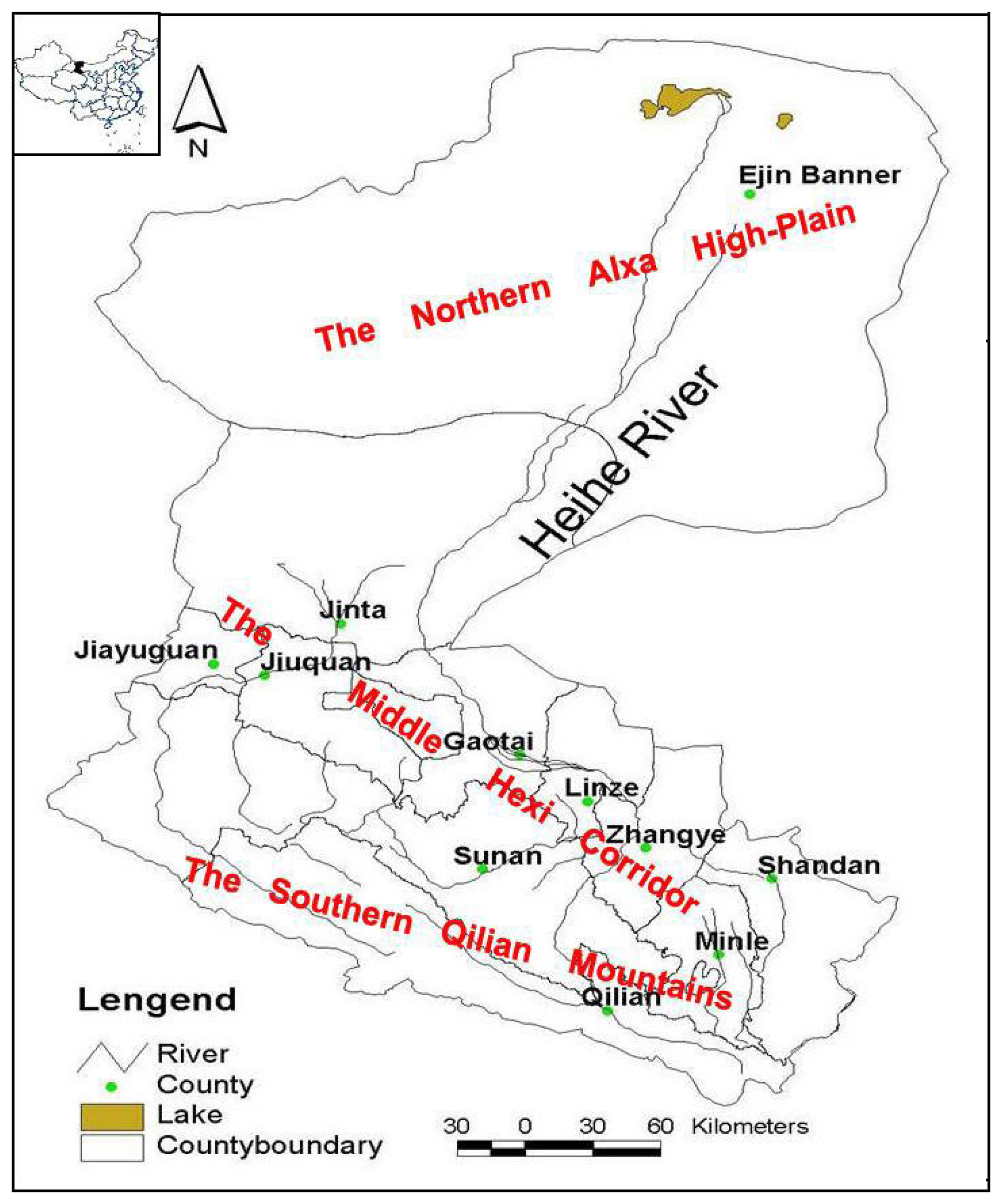
2.1. Study area
2.2 Methods
3. Results and Discussion
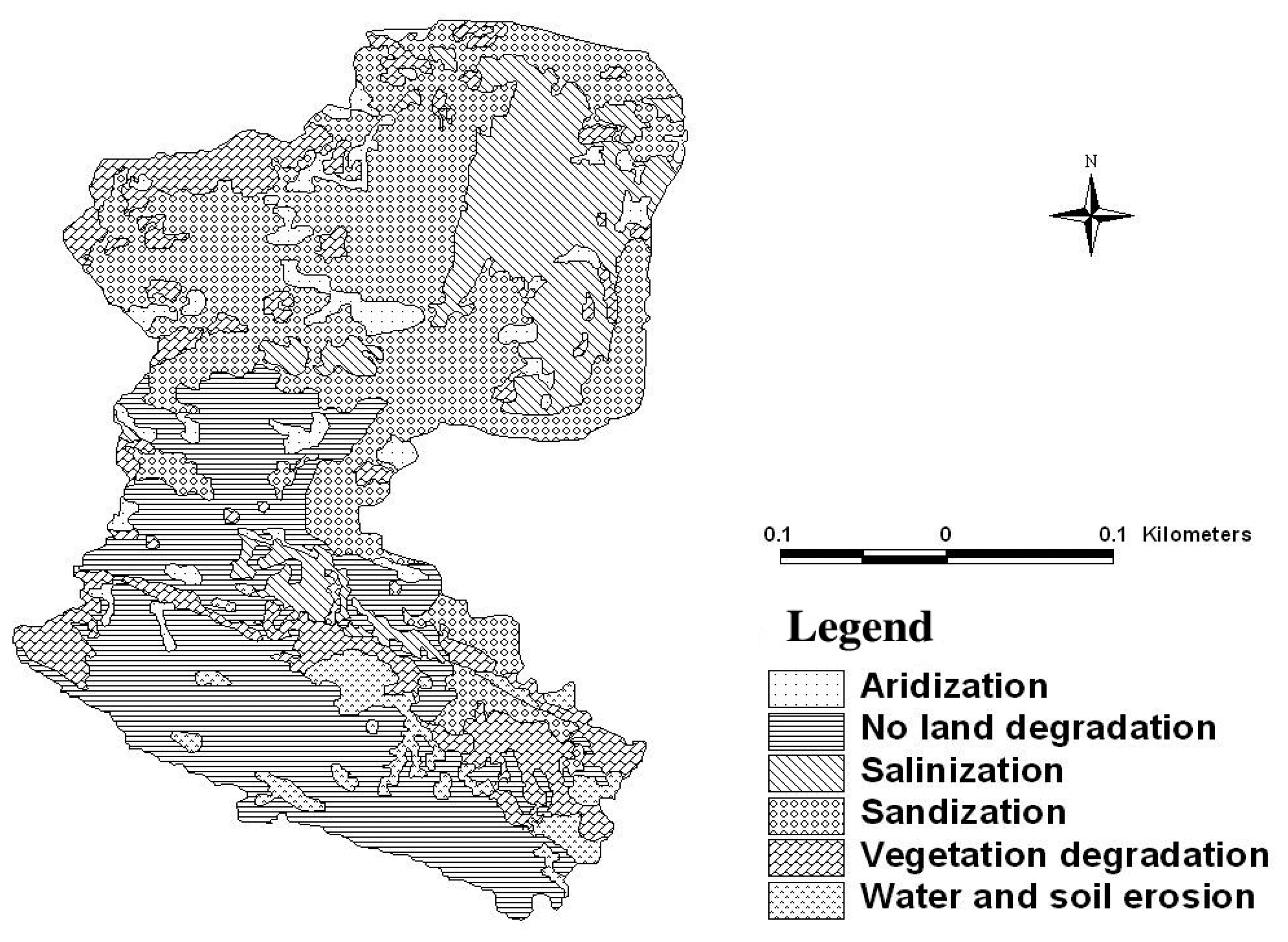
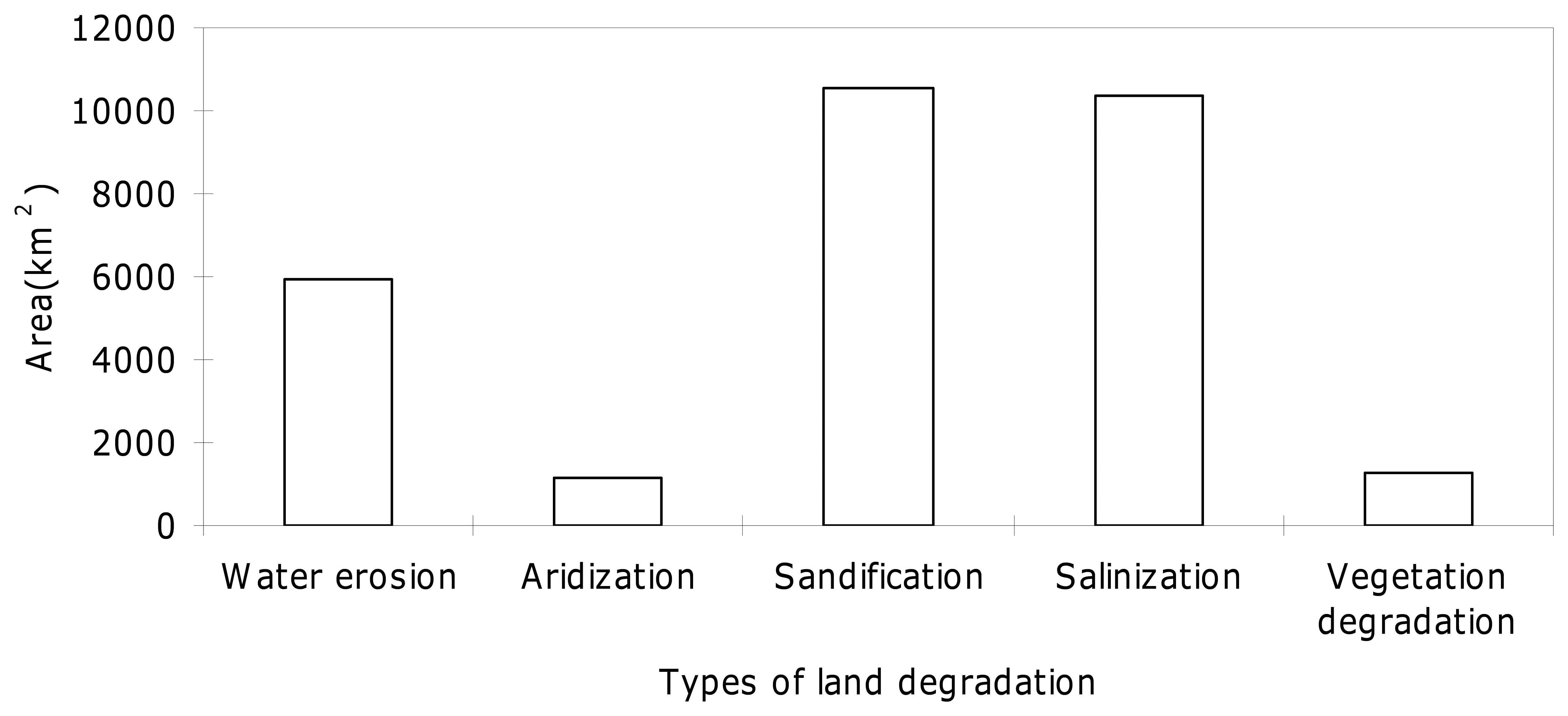
3.1. Types and distributions of degraded land in the Heihe River Basin
3.2. Assessment of degraded land in the Heihe River Basin
4. Conclusions
Acknowledgments
References
- Johnson, D.; Lewis, L. Degraded land: creation and destruction; Blackwell Scientific: Oxford, UK, 1995. [Google Scholar]
- Conacher, A.; Conacher, J. Rural degraded land in Australia; Oxford University Press: Melbourne, Australia, 1995. [Google Scholar]
- Chen, G.; Dong, Z.; Yan, P. Desertification: International research topics and research strategies of China. Explor. Nature 1996, 15, 1–5. [Google Scholar]
- Li, Y. Degraded land: its social economic dimensions. China Environ. Sci. 1998, 18, 92–97. [Google Scholar]
- Zhu, Z.; Wang, T. Trends of desertification and its rehabilitation in China. Desertif. Contr. Bull. 1993, 22, 27–30. [Google Scholar]
- Wang, T.; Wu, W.; Xue, X. Time-space evolution of desertification land in northern China. J. Desert Res. 2003, 23, 230–235. [Google Scholar]
- Zhang, Y.; Ning, D.; Smil, V. An estimate of economic loss for desertification in China. China Pop. Resour. Environ. 1996, 6, 45–49. [Google Scholar]
- Zha, Y.; Gao, J. Characteristics of desertification and its rehabilitation in China. J. Arid Environ. 1997, 37, 419–432. [Google Scholar]
- Scoging, H. The assessment of desertification. Geography 1993, 78, 190–193. [Google Scholar]
- Omojola, A.; Ezigbalike, I. Environment degradation assessment in the Sokoto-Rima River Basin using remote sensing and GIS techniques. Aust. J. Geodes. Photogr. Surv. 1993, 58, 55–68. [Google Scholar]
- Liu, Y. The evaluation method on ecosystem of sand degradation in arid area. Arid Zone Res. 1996, 13, 72–75. [Google Scholar]
- Mouat, D.; Lancaster, J.; Wade, T.; Wickham, J.; Fox, C.; Kepner, W.; Ball, T. Desertification evaluated using an integrated environmental assessment model. Environ. Monit. Assess. 1997, 48, 139–156. [Google Scholar]
- Rubio, J.; Bochet, E. Desertification indicators as diagnosis criteria for desertification risk assessment in Europe. J. Arid Environ. 1998, 39, 113–120. [Google Scholar]
- Qi, S.; Luo, F. Water environmental degradation of the Heihe River Basin in arid northwestern China. Environ. Monit. Assess. 2005, 108, 205–215. [Google Scholar]
- Luo, F.; Qi, S.; Xiao, H. Landscape change and sandy desertification in arid areas: a case study in the Zhangye Region of Gansu Province, China. Environ. Geol. 2005, 49, 90–97. [Google Scholar]
- Wu, B.; Ci, L. Landscape change and desertification development in the Mu Us Sandland, Northern China. J. Arid Environ. 2002, 50, 429–444. [Google Scholar]
- Chen, L. Land desertification and its control in the lower reaches of Hei River Basin. Nat. Res. 1996, 1, 35–43. [Google Scholar]
- Gao, Q.; Li, F. Case study of rational development and utilization of water resources in the Heihe River Basin.; Gansu Science and Technology Press: Lanzhou, P.R. China, 1991. [Google Scholar]
- Chen, L.; Qu, Y. Rational development and utilization on water and soil resources in Hexi region.; Science Press: Beijing, P.R. China, 1992. [Google Scholar]
- Chen, L.; Li, F. Soils in Hexi Region.; China Environment Science Press: Beijing, P.R. China, 2000. [Google Scholar]
- Zhu, H. Soil geography in world.; High Education Press: Beijing, P.R. China, 1985. [Google Scholar]
- Navas, A.; Machin, J. Assessing erosion risks in the gypsiferous steppe of Litigio (NE Spain): an approach using GIS. J. Arid Environ. 1997, 37, 433–441. [Google Scholar]
- Vasconcelos, M.; Mussa Biai, J.C.; Araujo, A.; Diniz, M. Land cover change in two protected areas of Guinea-Bissau (1956–1998). Appl. Geogr. 2002, 22, 139–156. [Google Scholar]
- Bocco, G.; Mendoza, M.; Velazquez, A. Remote sensing and GIS-based regional geo-morphological mapping: A tool for land use planning in developing countries. Geomorphology 2001, 39, 211–219. [Google Scholar]
- Li, F.; Qiu, B.; Peng, Q. Land resources evaluation map of the Heihe River Basin, China.; Xi'an Map Press: Xi'an, P.R. China, 1988. [Google Scholar]
- Zhu, Z.; Chen, G. Sandy desertification in China.; Sciences Press: Beijing, P.R. China, 1994. [Google Scholar]
- Satoshi, U. Diagnosis of degraded land in the semi-arid area of Asia and Pacific Region 10-using remote sensing data - JIRCAS's case study. 1995. http://www.gisdevelopment.net/aars/acrs/1995/ts7/ts7002pf.htm.
- Xiao, H. Compiling the land use map of the Heihe River Basin.; Lanzhou Institute of Desert Research, Chinese Academy of Sciences: Lanzhou, P.R. China, 1999. [Google Scholar]
- del Valle, H.; Elissalde, N.; Gagliardini, D.; Milovich, J. Status of desertification in the Patagonian Region: assessment and mapping from satellite imagery. Arid Soil Res. Rehab. 1998, 12, 95–122. [Google Scholar]


| Status of degraded land | Texture types | Spectral features |
|---|---|---|
| Slight | Smooth, fine, and coarse | High reflectance dominates, with linear and patchy features (homogeneous light-tone pattern) |
| Moderate | Mixed with fine and coarse and mottled | Moderate reflectance dominates with patchwork type features (associations of patches of light to moderately dark gray-tones, rounded or oval, isolated or connected) |
| Moderate to severe | Fine, coarse, mixed, mottled, rounded, subdued (blurred), rugged, and peaked divided | Moderate to low reflectance dominates, with patchwork type features (mosaic of intermingled patches of light and dark grey-tones, isolated or partially connected patches) |
| Severe | Fine, coarse, rough, and peaked divided | Low reflectance dominates with patchy-punctuated features (irregular, rounded or oval, and mostly isolated patches) |
| Categories (Geomorphic position-Vegetation-Soil) | Area (km2) | Percentage of degradation land | Percentage of basin area |
|---|---|---|---|
| Water erosion | 5932.6 | 19.16 | 4.3 |
| Sub-alpine-Crops-Mot-Ustic Cambisols | 428.0 | 0.15 | 0.03 |
| Middle mountain-Crops- Mot-Ustic Cambisols | 39.4 | 0.14 | 0.03 |
| Middle mountain-Stipa,Salsola passerine-Hap-Orthic Aridisols | 1292.9 | 4.46 | 1.00 |
| Middle mountain-Crops-Cal-Ustic Isohumisols | 107.1 | 0.37 | 0.08 |
| Middle mountain-Caragana stenophylla,Stipa krylovii-Hap- Ustic Isohumisols | 245.3 | 0.85 | 0.19 |
| Middle mountain-Stipa spp.,Sympegma regelii-Cal- Orthic Aridisols | 213.3 | 0.74 | 0.17 |
| Low mountain- Crops-Cal-Ustic Isohumisols | 130.2 | 0.45 | 0.10 |
| Middle mountain Crops-Hap-Ustic Isohumisols | 345.2 | 1.19 | 0.27 |
| Middle mountain-Agropyron cristatum, Stipa spp.- Cal-Ustic Isohumisols | 1914.4 | 6.61 | 1.48 |
| Middle mountain- Stipa spp., Artemisia frigida, Caragana spp.- Hap-Ustic Isohumisols | 1216.8 | 4.20 | 0.94 |
| Aridization | 1169.4 | 4.03 | 0.90 |
| Bottomland-Phragmites communis, Achnatherum splendens, Glycyrrhiza inflate-Mot- Ustic Cambisols | 829.5 | 2.86 | 0.64 |
| Wet Bottomland-Populus euphratica, Elaeagnus angustifolia, Tamarix spp.-Och-Aquic Cambisols | 339.9 | 1.17 | 0.26 |
| Salinization | 10391.3 | 35.86 | 8.05 |
| Artificial oasis-Crops-Pas-Sil-Orthic Anthrosols | 302.2 | 1.04 | 0.23 |
| Wet Bottomland-Phragmites communis, Achnatherum splendens-Mot-Ustic Cambisols | 911.9 | 3.15 | 0.71 |
| Wet Bottomland-Phragmites communis, Tamarix spp., Sophara alopecuroides, Lycium uthenicum-Pas-Gen-Aquic Cambisols | 2830.6 | 9.77 | 2.19 |
| Artificial forest-Elaeagnus angustifolia, Populus spp.-Pas-Sil-Ustic Cambisols | 67.7 | 0.23 | 0.05 |
| Wet Bottomland- Tamarix spp., Phragmites communis, Elaeagnus angustifolia, Populus euphratica-Pas-Och-Aquic Cambisols | 433.0 | 1.49 | 0.34 |
| Bottomland-Phragmites communis, Tamarix spp., Populus euphratica-Aqu-Orthic Halosols | 1436.3 | 4.96 | 1.11 |
| Bottomland-Kalidium gracile, Lycium ruthenicum, Orthic Halosols alostachys belangeriana, Tamarix spp.-Ari- Orthic Halosols | 362.0 | 1.25 | 0.28 |
| Loam flat-Karelinia caspica, Glycyrrhiza inflate, Tamarix spp., Phragmites communis, Aqu-Orthic Halosols | 2 554.4 | 8.82 | 1.98 |
| Bottomland- Ari- Orthic Halosols | 1493.2 | 5.15 | 1.1 6 |
| Sandification | 10571.8 | 36.49 | 8.19 |
| Stabilised dune-Tamarix spp. Haloxylon ammodendron, Nitraria spp.-Ari-Sandic Entisols | 1084.0 | 3.74 | 0.84 |
| Semi- Stabilised dune-Haloxylon ammodendron, Reaumuria soongorica-Ari-Sandic Entisols | 1264.1 | 4.36 | 0.98 |
| Semi- Stabilised dune-Artemisia spp., Populus euphratica, Tamarix spp.- Ari-Sandic Entisols | 1450.7 | 5.01 | 1.12 |
| Sandy flat-Ari-Sandic Entisols | 350.3 | 1.21 | 0.27 |
| Mobile dune-Ari-Sandic Entisols | 6 422.7 | 22.17 | 4.98 |
| Vegetation degradation | 1290.4 | 4.45 | 1.00 |
| Middle mountain-Stipa spp., Sympegma regelii, Reaumuria soongorica-Hap-Orthic Aridisols | 907.9 | 3.13 | 0.70 |
| Loam flat- Sympegma regelii, Salsola passerine, Artemisia spp.-Hap-Orthic Aridisols-Loam flat | 254.7 | 0.88 | 0.20 |
| Middle mountain river valley-Carerx Montana, Kobresia spp., weeds-Mot-Udic Cambisols | 36.8 | 0.13 | 0.03 |
| Alluvial flood plain-Stipa spp., Salsola passerine, Artemisia spp.-Cal-Orthic Aridisols | 64.5 | 0.22 | 0.05 |
| Wet bottomland-Phragmites communis, Achnatherum splendens, Aneurolepidium dasystachys, Calamagrogstis spp.-Gen-Aquic Cambisols-Wet bottomland | 26.5 | 0.09 | 0.02 |
| Total | 29355.5 | 100.00 | 22.58 |
| Assessment factors | Slight | Moderate | Moderate to severe | Severe |
|---|---|---|---|---|
| Soil salt in 0-30 cm (%) | 0.5∼1 | 1.0∼1.5 | 1.5∼2.0 | >2.0 |
| Soil moisture in 0-100 cm (w %) | 5∼12 | 2∼8 | 0.1∼5 | < 0.1 |
| Time of water logging (months) | <2 | 2∼4 | 4∼6 | > 6 |
| Area of shifting sands and sand dunes (%) | 10∼20 | 20∼30 | 30∼50 | > 50 |
| Coverage of vegetation (%) | > 60 | 60∼40 | 40∼20 | < 20 |
| Grass yield (Dry kg ha-1) | 800∼600 | 600∼500 | 500∼400 | < 400 |
| Slope gradient | 10∼15 | 15∼20 | 20∼25 | > 25 |
| Ranks | Categories | Land-use types | Area (km2) |
|---|---|---|---|
| Slight (5,221.0 km2) | Vegetation degradation | Middle mountain-Stipa spp., Sympegma regelii, Reaumuria soongorica-Hap-Orthic Aridisols | 907.9 |
| Loam flat- Sympegma regelii, Salsola passerine, Artemisia spp.-Hap-Orthic Aridisols-Loam flat | 254.7 | ||
| Water erosion | Sub-alpine-Crops-Mot-Ustic Cambisols | 428.0 | |
| Middle mountain-Crops- Mot-Ustic Cambisols | 39.4 | ||
| Middle mountain-Stipa,Salsola passerine-Hap-Orthic Aridisols | 1,292.9 | ||
| Salinization | Artificial oasis-Crops-Pas-Sil-Orthic anthrosols | 302.2 | |
| Wet Bottomland-Phragmites communis, Achnatherum splendens-Mot-Ustic Cambisols | 911.9 | ||
| Sandification | Stabilised dune-Tamarix spp. Haloxylon ammodendron, Nitraria spp.-Ari-Sandic Entisols | 1,084.0 | |
| Moderate (7,669.2 km2) | Vegetation degradation | Middle mountain river valley-Carerx Montana, Kobresia spp., weeds-Mot-Udic Cambisols | 36.8 |
| Alluvial flood plain-Stipa spp., Salsola passerine, Artemisia spp.-Cal-Orthic Aridisols | 64.5 | ||
| Water erosion | Middle mountain-Crops-Cal-Ustic Isohumisols | 107.1 | |
| Middle mountain-Caragana stenophylla,Stipa krylovii-Hap- Ustic Isohumisols | 245.3 | ||
| Aridization | Bottomland-Phragmites communis, Achnatherum splendens, Glycyrrhiza inflate-Mot- Ustic Cambisols | 829.5 | |
| Wet Bottomland-Populus euphratica, Elaeagnus angustifolia, Tamarix spp.-Och-Aquic Cambisols | 339.9 | ||
| Salinization | Wet Bottomland-Phragmites communis, Tamarix spp., Sophara alopecuroides, Lycium uthenicum-Pas-Gen-Aquic Cambisols | 2,830.6 | |
| Artificial forest-Elaeagnus angustifolia, Populus spp.-Pas-Sil-Ustic Cambisols | 67.7 | ||
| Wet Bottomland- Tamarix spp., Phragmites communis, Elaeagnus angustifolia, Populus euphratica-Pas-Och-Aquic Cambisols | 433.0 | ||
| Sandification | Semi- Stabilised dune-Haloxylon ammodendron, Reaumuria soongorica-Ari-Sandic Entisols | 1,264.1 | |
| Semi- Stabilised dune-Artemisia spp., Populus euphratica, Tamarix spp.- Ari-Sandic Entisols | 1,450.7 | ||
| Moderate to severe (2,156.6 km2) | Vegetation degradation | Wet bottomland-Phragmites communis, Achnatherum splendens, Aneurolepidium dasystachys, Calamagrogstis spp.-Gen-Aquic Cambisols-Wet bottomland | 26.5 |
| Water erosion | Middle mountain-Stipa spp.,Sympegma regelii-Cal- Orthic Aridisols | 213.3 | |
| Low mountain- Crops-Cal-Ustic Isohumisols | 130.2 | ||
| Salinization | Bottomland-Phragmites communis, Tamarix spp., Populus euphratica-Aqu-Orthic Halosols | 1,436.3 | |
| Sandification | Sandy flat-Ari-Sandic Entisols | 350.3 | |
| Severe (14,308.7 km2) | Water erosion | Middle mountain Crops-Hap-Ustic Isohumisols | 345.2 |
| Middle mountain-Agropyron cristatum, Stipa spp.- Cal-Ustic Isohumisols | 1,914.4 | ||
| Middle mountain- Stipa spp., Artemisia frigida, Caragana spp.- Hap-Ustic Isohumisols | 1,216.8 | ||
| Salinization | Bottomland-Kalidium gracile, Lycium ruthenicum, Orthic Halosols alostachys belangeriana, Tamarix spp.-Ari- Orthic Halosols | 362.0 | |
| Loam flat-Karelinia caspica, Glycyrrhiza inflate, Tamarix spp., Phragmites communis, Aqu-Orthic Halosols | 2,554.4 | ||
| Bottomland- Ari- Orthic Halosols | 1,493.2 | ||
| Sandification | Mobile dune-Ari-Sandic Entisols | 6,422.7 | |
| Total degraded land | 29,355.5 | ||
© 2007 by MDPI ( http://www.mdpi.org). Reproduction is permitted for noncommercial purposes.
Share and Cite
Qi, S.; Cai, Y. Mapping and Assessment of Degraded Land in the Heihe River Basin, Arid Northwestern China. Sensors 2007, 7, 2565-2578. https://doi.org/10.3390/s7112565
Qi S, Cai Y. Mapping and Assessment of Degraded Land in the Heihe River Basin, Arid Northwestern China. Sensors. 2007; 7(11):2565-2578. https://doi.org/10.3390/s7112565
Chicago/Turabian StyleQi, Shanzhong, and Yumin Cai. 2007. "Mapping and Assessment of Degraded Land in the Heihe River Basin, Arid Northwestern China" Sensors 7, no. 11: 2565-2578. https://doi.org/10.3390/s7112565