Land 2022, 11(12), 2266; https://doi.org/10.3390/land11122266 - 11 Dec 2022
Cited by 2 | Viewed by 4363
Abstract
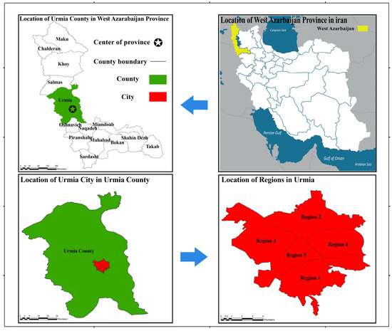
In recent decades, the concept of a knowledge-based city has been proposed as one of the most important concepts in urban planning. The present study evaluates the ability to localize urban planning indicators in the city of Urmia and determine the desirability of
[...] Read more.
In recent decades, the concept of a knowledge-based city has been proposed as one of the most important concepts in urban planning. The present study evaluates the ability to localize urban planning indicators in the city of Urmia and determine the desirability of knowledge-based city indicators to provide coherent policies and strategies to achieve sustainable development and a knowledge-based city. Localization is the adaptation of global patterns and methods of development and planning to the internal conditions of the local community. In order to collect data from documents and library studies, experts’ opinions have been used by the Delphi method. Then, indicators related to local urban planning and knowledge-based city were extracted. The present study’s statistical population is 20 specialists and experts related to the research topic through the survey method. In order to analyze the research data, a one-sample t-test was used to assess the ability to localize aspects of urban planning in the city of Urmia. In order to investigate the degree of correlation and factor load of each urban planning indicator, confirmatory factor analysis was used. Using the Swara technique, the desirability and knowledge-based city indicators’ priority level has been evaluated and analyzed. The research results indicate that each of the economic, social, physical, environmental, and managerial aspects of urban planning can be localized in the city of Urmia. Moreover, the situation of Urmia in some aspects is in a situation of incompatibility in terms of the feasibility of the knowledge-based city’s policies. In order to improve the current situation and achieve the desired goals, suggestions have been made in various aspects.
Full article
(This article belongs to the Special Issue Sustainable Urban Planning Models for New Smart Cities and Effective Management of Land Take Dynamics)
►
Show Figures
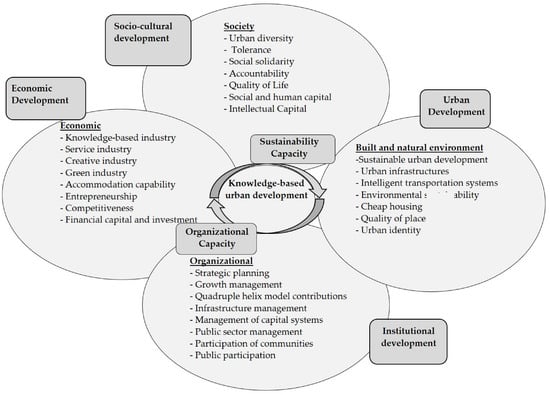
Figure 1


