
Satellite Characterization of Methane Point Sources by Offshore Oil and Gas PlatForms †

 ,
,  , , and
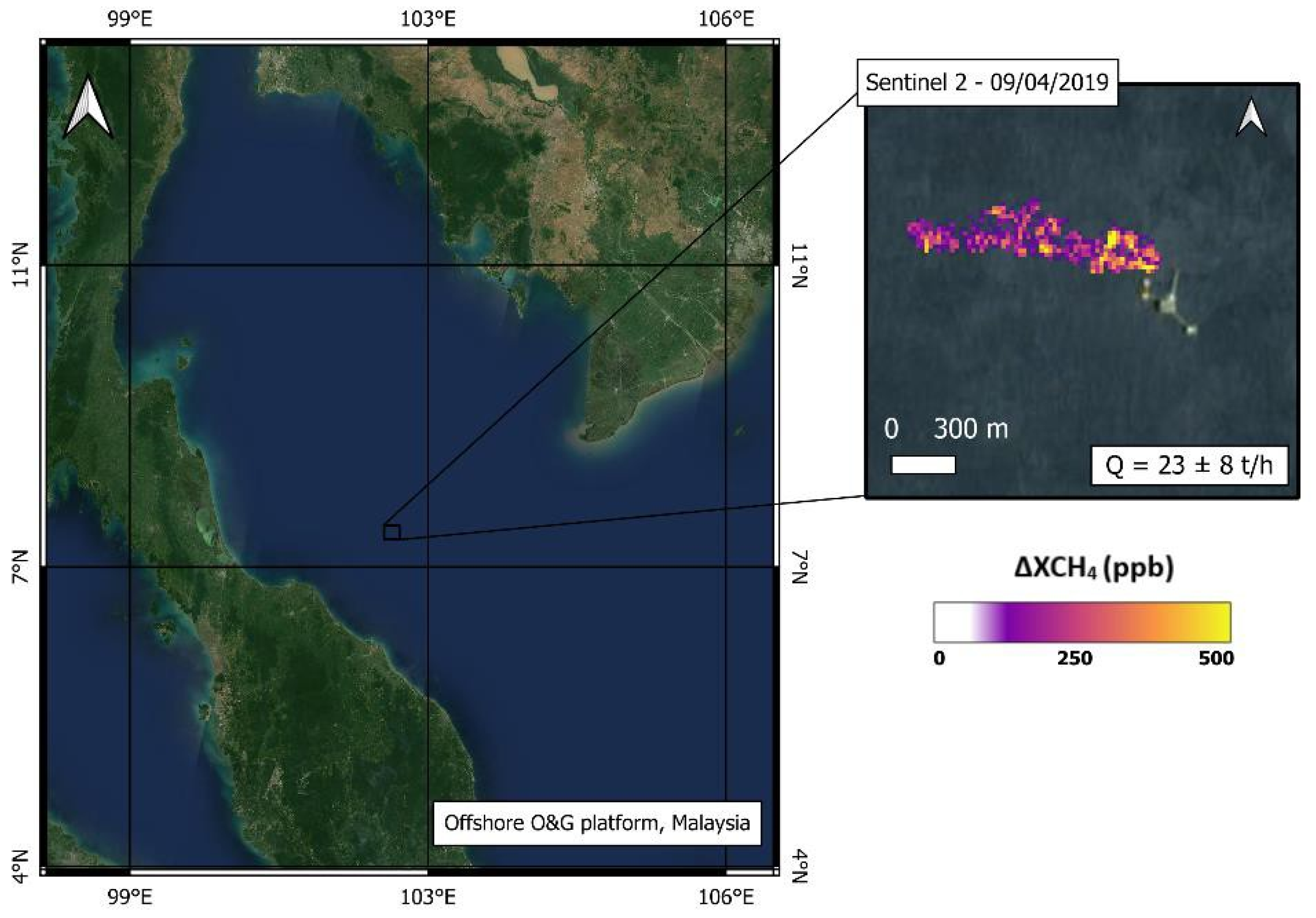
Abstract
:1. Introduction
2. Materials and Methods
2.1. Study Areas
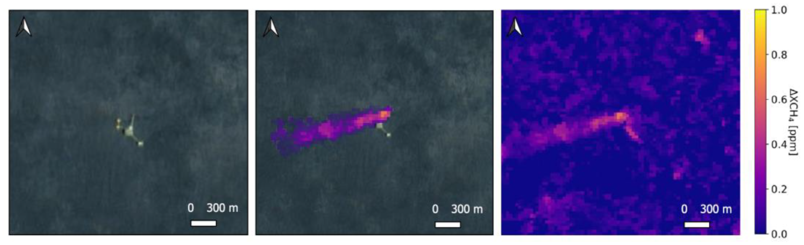
2.2. Methane Emission Detection
2.3. Verification of Methane Plume
3. Results
3.1. Multiespectral Results
3.2. Hyperspectral Results
4. Conclusions
Author Contributions
Funding
Data Availability Statement
Acknowledgments
Conflicts of Interest
References
- Etminan, M.; Myhre, G.; Highwood, E.J.; Shine, K.P. Radiative forcing of carbon dioxide, methane, and nitrous oxide: A significant revision of the methane radiative forcing. Geophys. Res. Lett. 2016, 43. [Google Scholar] [CrossRef]
- Gorroño, J.; Varon, D.J.; Irakulis-Loitxate, I.; Guanter, L. Understanding the potential of Sentinel-2 for monitoring methane point emissions. Atmos. Meas. Tech. 2023, 16, 89–107. [Google Scholar] [CrossRef]
- UNEP, 2021. Global Methane Assessment: Benets and Costs of Mitigating Methane Emissions. Available online: https://www.unep.org/resources/report/global-methane-assessment-benefits-and-costs-mitigating-methane-emissions (accessed on 13 March 2023).
- Global Crude Oil Onshore and Offshore Production Distribution 2025|Statista. Available online: https://www.statista.com/statistics/624138/distribution-of-crude-oil-production-worldwide-onshore-and-offshore/ (accessed on 27 January 2022).
- Irakulis-Loitxate, I.; Gorroño, J.; Zavala-Araiza, D.; Guanter, L. Satellites Detect a Methane Ultra-emission Event from an Offshore Platform in the Gulf of Mexico. Environ. Sci. Technol. Lett. 2022, 9, 520–525. [Google Scholar] [CrossRef]
- Brown, P.F.; Saunier, S.; Simon, M.; Cruz, B.H. Overview of Methane Detection and Measurement Technologies for Off-Shore Applications; Carbon Limits AS for the Norwegian Oil and Gas Association: Oslo, Norway, 2020. [Google Scholar]
- Kay, S.; Hedley, J.D.; Lavender, S. Sun Glint Correction of High and Low Spatial Resolution Images of Aquatic Scenes: A Review of Methods for Visible and Near-Infrared Wavelengths. Remote Sens. 2009, 1, 697–730. [Google Scholar] [CrossRef]
- Omara, M.; Gautam, R.; O’Brien, M.A.; Himmelberger, A.; Franco, A.; Meisenhelder, K.; Hauser, G.; Lyon, D.R.; Chulakadaba, A.; Miller, C.C.; et al. Developing a spatially explicit global oil and gas infrastructure database for characterizing methane emission sources at high resolution. Earth Syst. Sci. Data 2023, 15, 3761–3790. [Google Scholar] [CrossRef]
- Varon, D.J.; Jervis, D.; McKeever, J.; Spence, I.; Gains, D.; Jacob, D.J. High-frequency monitoring of anomalous methane point sources with multispectral Sentinel-2 satellite observations. Atmos. Meas. Tech. 2021, 14, 2771–2785. [Google Scholar] [CrossRef]
- Molod, A.; Takacs, L.; Suarez, M.; Bacmeister, J.; Song, I.-S.; Eichmann, A. The GEOS-5 Atmospheric General Circulation Model: Mean Climate and Development from MERRA to Fortuna; NASA: Greenbelt, MD, USA, 2012; NASA TM-2012-104606.


Disclaimer/Publisher’s Note: The statements, opinions and data contained in all publications are solely those of the individual author(s) and contributor(s) and not of MDPI and/or the editor(s). MDPI and/or the editor(s) disclaim responsibility for any injury to people or property resulting from any ideas, methods, instructions or products referred to in the content. |
© 2024 by the authors. Licensee MDPI, Basel, Switzerland. This article is an open access article distributed under the terms and conditions of the Creative Commons Attribution (CC BY) license (https://creativecommons.org/licenses/by/4.0/).
Share and Cite
Valverde, A.; Irakulis-Loitxate, I.; Roger, J.; Gorroño, J.; Guanter, L. Satellite Characterization of Methane Point Sources by Offshore Oil and Gas PlatForms. Environ. Sci. Proc. 2023, 28, 22. https://doi.org/10.3390/environsciproc2023028022
Valverde A, Irakulis-Loitxate I, Roger J, Gorroño J, Guanter L. Satellite Characterization of Methane Point Sources by Offshore Oil and Gas PlatForms. Environmental Sciences Proceedings. 2023; 28(1):22. https://doi.org/10.3390/environsciproc2023028022
Chicago/Turabian StyleValverde, Adriana, Itziar Irakulis-Loitxate, Javier Roger, Javier Gorroño, and Luis Guanter. 2023. "Satellite Characterization of Methane Point Sources by Offshore Oil and Gas PlatForms" Environmental Sciences Proceedings 28, no. 1: 22. https://doi.org/10.3390/environsciproc2023028022