Proceeding Paper

Phenotyping Conservation Agriculture Management Effects on Ground and Aerial Remote Sensing Assessments of Maize Hybrid Performance in Zimbabwe †

by
Adrian Gracia-Romero
1,
Omar Vergara-Díaz
1,
Christian Thierfelder
2,
Jill E. Cairns
2,
Shawn C. Kefauver
1,* and
José L. Araus
1
1
Integrative Crop Ecophysiology Group, Plant Physiology Section, Faculty of Biology, University of Barcelona, 08028 Barcelona, Spain
2
CIMMYT Southern Africa Regional Office, P.O. Box MP 163, Mt Pleasant, 12.5 km Peg Mazowe Road Harare, Zimbabwe
*
Author to whom correspondence should be addressed.
Presented at the 2nd International Electronic Conference on Remote Sensing, 22 March–5 April 2018; Available online: https://sciforum.net/conference/ecrs-2.
Proceedings 2018, 2(7), 367; https://doi.org/10.3390/ecrs-2-05181
Published: 23 March 2018
(This article belongs to the Proceedings of The 2nd International Electronic Conference on Remote Sensing)

Abstract

:
In the coming decades, Sub-Saharan Africa faces challenges to sustainably increase food production while keeping pace with continued population growth. Conservation agriculture (CA) has been proposed to enhance soil health and productivity to respond to this situation. To increase maize yields, the main staple food in SSA, the selection of suitable genotypes has been explored using remote sensing tools. They may play a fundamental role in overcoming the limitations of data collection and processing in large scale phenotyping studies. We present the result of a study in which Red-Green-Blue and multispectral indexes were evaluated for assessing maize performance under conventional ploughing (CP) and CA practices. The measurements were conducted on seedlings at ground level and from an unmanned aerial vehicle platform. Most indexes were significantly affected by tillage conditions, increasing their values from CP to CA. Indexes derived from the RGB-images related to canopy greenness performed better at assessing yield differences, potentially due to the greater resolution of the RGB compared with the multispectral data, although this performance was more precise for CP than CA. The correlations of the multispectral indexes with yield were improved by applying a soil-mask derived from a NDVI threshold.

1. Introduction

Traditional practices of land preparation involve soil tillage through moldboard ploughing, to soften the seedbed, to ensure uniform germination, to remove weed plants, and to release soil nutrients through mineralization and oxidation. However, this mechanical disturbance is leading to a decline in organic matter, an increase of the loss of water by runoff, and, finally, to soil erosion [1]. Over the next century, Sub-Saharan Africa (SSA) is expected to be particularly vulnerable due to the range of projected impacts: e.g., multiple stresses and the low adaptive capacity of current cropping systems, as well as population increase [2]. Maize (Zea mays L.) is the principal staple food crop in large parts of SSA, and is usually grown in small-holder farming systems under rainfed conditions. Limited availability of inputs is a leading factor contributing to low yields that in turn are not able to keep pace with the food demand [3]. Hence, one of the most effective pathways to adaptation is to focus on breeding new varieties but also in changing crop management [4]. In light of soil degradation, conservation agriculture (CA) practices have been proposed as an alternative to tillage-based agriculture in SSA as a pragmatic solution to increase production while conserving the natural resource base [5]. CA is a set of core principles, including minimum soil disturbance; permanent soil cover; and diversified crop rotations supported by integrated soil, crop, and water management, which is aimed at reducing and/or reverting many negative effects of conventional farming practices [6]. However, most crop cultivars currently grown under CA have been developed under conventional or full tillage conditions, and it is likely that relevant genetic adaptations to CA conditions may have been removed during previous breeding efforts. Specialized sensors have become an important component for crop monitoring, particularly to improve precision, efficiency, and throughput in phenotyping [7]. Remote sensing indexes have largely demonstrated their various applications in agriculture, including yield prediction, stress detection, and control of plant diseases under a wide range of growing and environmental conditions [8]. The classical approach has involved the use of multispectral data for the development of numerous vegetation indexes to assess biomass (e.g., Normalized Difference Vegetation Index, NDVI), water content (e.g., Water Band Index, WBI), or pigment composition (e.g., Modified Chlorophyll Absorption Ratio Index, MCARI) in yield studies. At present, the use of information derived from RGB images (using red, green, and blue color bands) acquired with conventional digital cameras represents a low-cost alternative. Moreover, recent technological advances have led the incorporation of these sensors into aerial based platforms, enabling the simultaneous characterization of a larger number of plots, which may help to minimize the effect of changing environmental conditions during critical sampling moments [7].
The aim of the present study was to evaluate the efficiency of a set of remote sensing indexes in assessing the yield differences of different maize hybrids at early growth stages under conventionally ploughed (CP) and zero-tillage (CA) conditions. Different categories of sensors were tested, including RGB cameras (placed on an aerial platform as well as at ground level), alongside multispectral and thermal cameras (both installed on the aerial platform) and an active sensor portable field spectrometer designed to measure the NDVI at ground level.

2. Materials and Methods

2.1. Site Description, Plant Material, and Experimental Design

The experiment was conducted at Domboshawa Training Centre (17°37′ S, 31°10′ E, and 1560 m.a.s.l.), situated at the north-east of Harare (Zimbabwe) during the 2015/2016 crop season. Seven maize drought-tolerant commercial hybrids and one drought-sensitive commercial control variety were manually planted on 14 December 2015 in plots of 23 m2 (5 × 4.6 m) with four lines per plot. Two differential plot management regiments were applied to the field since 2009. One half was managed using no-tillage and the application of 2.5–3.0 Mg ha−1 of maize stover to all the plots. The other half was conventionally ploughed and without any residue management.

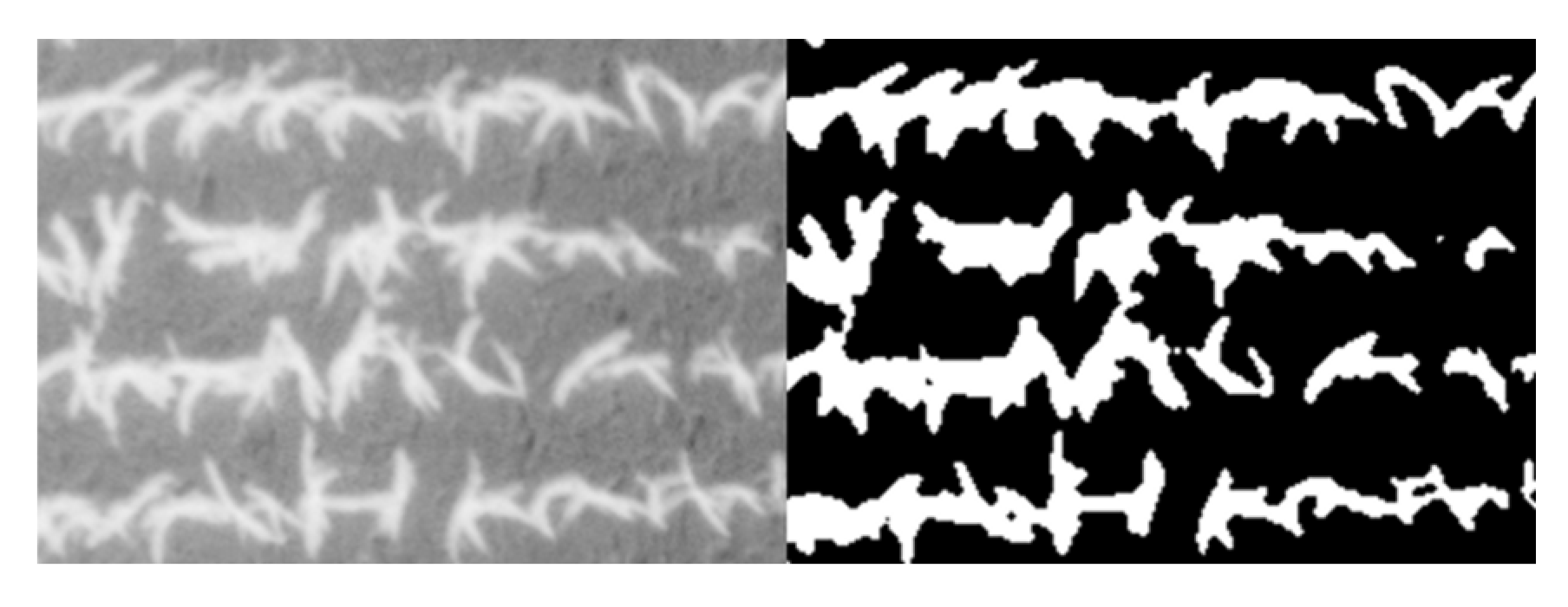
2.2. Proximal (Ground) and Aerial Data Colleciton

Proximal (ground) data was collected 45 days after sowing on 28 January 2016 when the hybrids reached the stage of 4 to 6 leaves. The Normalized Difference Vegetation Index (NDVI) was determined at ground level using a portable spectrometer (GreenSeeker handheld crop sensor, Trimble, Sunnyvale, CA, USA), by passing the sensor over the middle of each plot at a constant height of 0.5 m above and perpendicular to the canopy. One RGB picture was taken per plot, holding the camera at 80 cm above the plant canopy in a zenithal plane and focusing near the center of each plot. The conventional digital camera used was an Olympus OM-D (Olympus, Tokyo, Japan), with a 16-megapixel (MP) image sensor size of 17.3 × 13.0 mm saved in JPEG format with a resolution of 4608 × 3072 pixels. As the plots were too big for a single photograph, three different images samples were taken of each central row. RGB images were subsequently analyzed using a version of the Breedpix 0.2 software adapted to JAVA8 and other RGB image analyses together integrated as a freely available plugin within FIJI; https://github.com/George-haddad/CIMMYT). This software enables the extraction of RGB vegetation indexes in relation to different color properties. Essentially, the indexes are based on either the average color of the entire image, in diverse units related to its “greenness”, or on the fraction of pixels classified as green canopy relative to the total number of pixels in the image.
Furthermore, aerial measurements were acquired during the same visit as the ground data using an unmanned aerial vehicle (UAV) (Mikrokopter OktoXL 6S12, Moormerland, Germany) flying at an altitude of 30 m. Two flights were performed; on one flight only the RGB digital camera was mounted and the other included both the multispectral and thermal cameras. The RGB aerial images were obtained using a Lumix GX7 (Panasonic, Osaka, Japan) digital mirrorless camera with an 16-MP image sensor of 17.3 × 13.0 mm using a 20 mm lens and saved in JPEG format with a resolution of 4592 × 3448 pixels. For the multispectral data, a camera covering wavelengths in the visible and near infrared regions of the spectrum was used (micro-MCA12 with a dedicated Incident Light Sensor (ILS), Tetracam Inc., Chatsworth, CA, USA). The camera consists of twelve independent image sensors and filters, with one sensor dedicated to calibration (ILS) that includes 11 micro filters corresponding to the exact wavelengths of the 11 downwards looking full image sensors. It captures 15.6-MP of image data as 12 × 1.3-MP images. The multispectral images acquired were aligned and calibrated to reflectance using PixelWrench II version 1.2.2.2. To obtain an accurate orthomosaic of the pre-processed aerial images from each sensor, a 3D reconstruction was produced using Agisoft PhotoScan Professional. A total of 30 overlapped images were needed for each orthomosaic. Then, the procedure of cropping the plots was done using the open source image analysis platform FIJI (Fiji is Just ImageJ; http://fiji.sc/Fiji), in which regions of interest were exported, taking care that exactly the same ground area was segmented for each plot across all treatments. For the formulation of the different multispectral indexes, we developed a customized FIJI macro code for the calculation of the multispectral indexes through two different approaches: at the whole plot level and on vegetation only by applying an NDVI mask of values of 0.4-1 to remove non vegetation pixels (Figure 1).

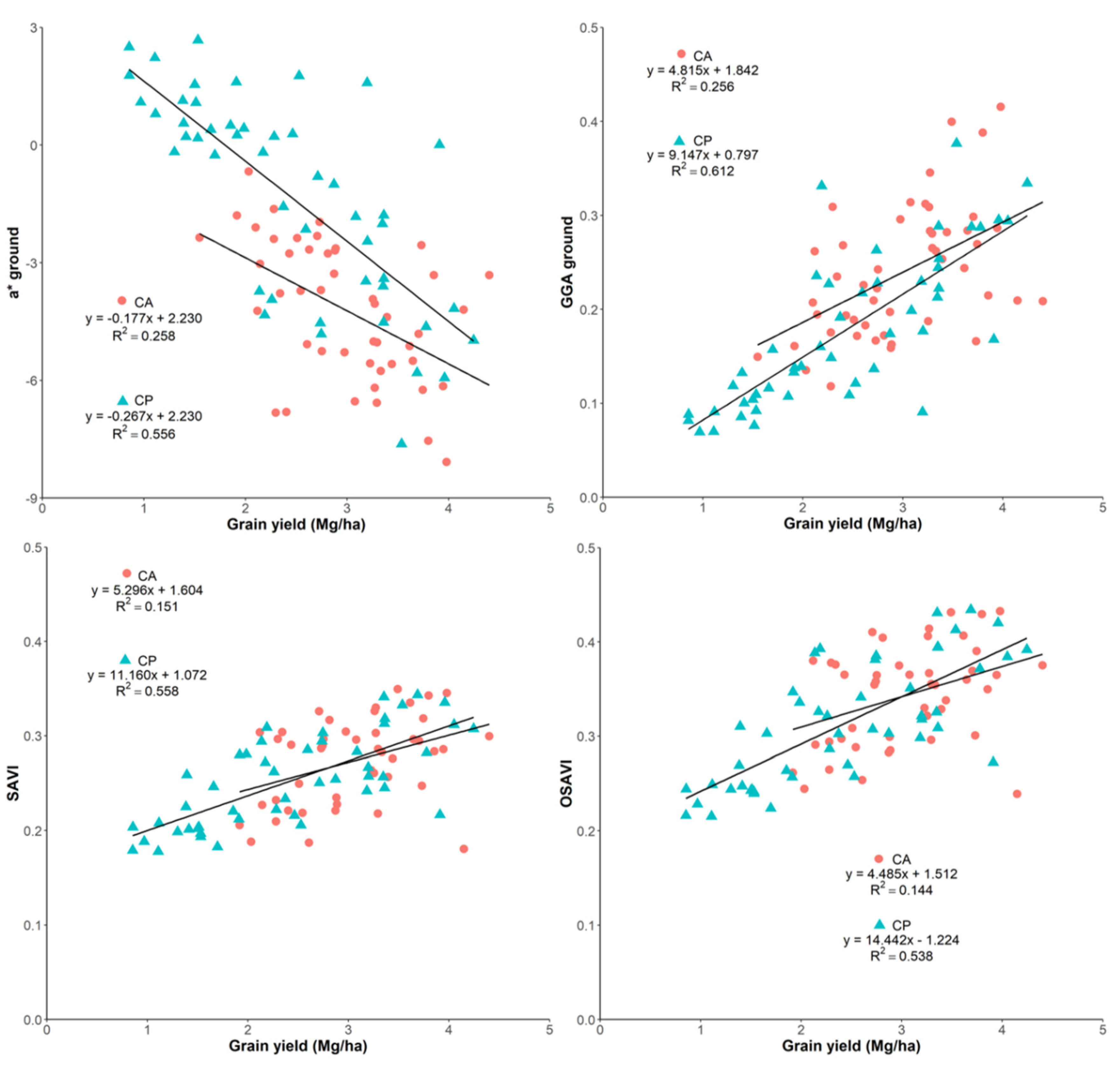
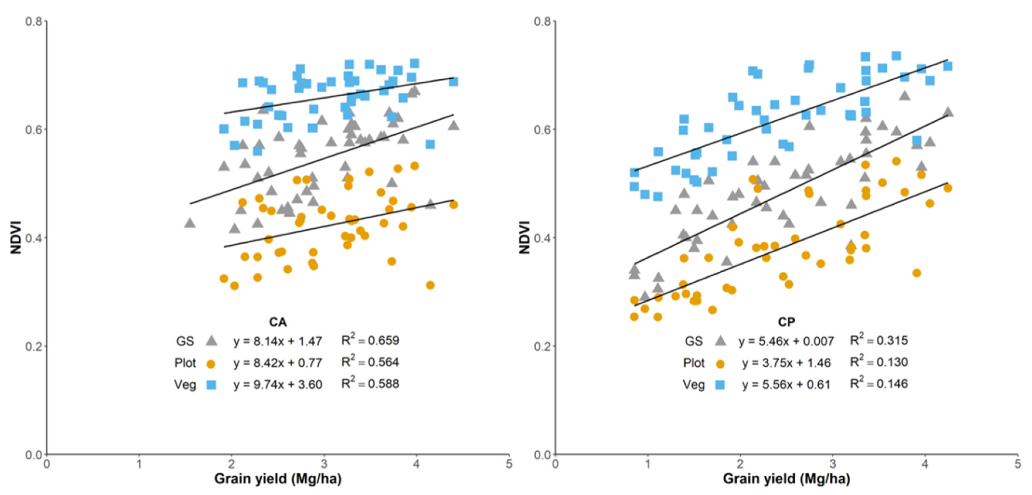
3. Results and Discussion

3.1. Implications of Growing Conditions on Yield

CA practices have been proposed as potential systems to increase crop yield, [1,9]. As can be seen in our results, grain yield was significantly greater under CA conditions (p < 0.0001), by almost 20% relative to the CP. Since crop management has led to a considerable increase in yield, changes in genotype may be an option to make use of the enhanced yield potential provided by this environmental factor. Crops have been grown on conventional tillage for many years, and genes governing the adaptation to CA either have been lost over time through untargeted selection or have become redundant [10]. However, the varieties used in this experiment only showed significant differences in yield under CA (p < 0.001), not under CP (p < 0.147). This may suggest the existence of some traits linked to tillage with a direct effect on improving yield. Herrera et al. (2013) [11] conclude that traits associated with emergence (early vigor) and resistance to diseases may increase genotype performance under CA. Thus, these results reinforce the need to further evaluate genotypic performance of varieties developed and selected in CP and test them under no-tillage conditions.

3.2. Comparative Performance of the Vegetation Indexes at Determining Differences in Grain Yield

RGB imaging and processing have become major tools for phenotyping, and its ability to determine plant performance in terms of biomass and yield has been demonstrated again in this study. The indexes that performed better in assessing differences in yield were the ones more related to canopy greenness, such as a* or GGA (Figure 2). Therefore, elevated values of these indexes, driven by higher biomass levels, help to anticipate higher yields even at early growing stages [12]. Just like RGB, the multispectral indexes that are more sensitive to the green biomass (e.g., NDVI) and its reformulations as the SAVI, OSAVI, and RDVI were the best correlated with GY (Figure 2). Those indexes contain information from the red reflectance region [13,14,15], which increases with a reduction of the biomass density, making them ideal for identifying differences in vigor at early growing stages.
Although significant results were obtained, these indexes did not perform equally in assessing yield differences within the different tillage growing conditions. The strengths of the indexes (both RGB and multispectral) correlations against yield were much lower in CA compared with CP (Figure 3). The reason for this is assumed to be the added noise derived from the crop residue soil coverage. According to the FAO definition, the soil surface has to be covered at least by 30% to qualify as CA [16], which may have influenced remote sensing readings under CA. Due to this fundamental difference between CA and CP, it is difficult to segregate between biomass from the plant and residue cover. The application of an NDVI mask on the multispectral images effectively reduced background reflectance and increased their correlations statistically, although the improvements were minor. Even having a distinct color, the CA background influenced the images mildly and supported the assessment of vegetation area, particularly in RGB images that are based on the portion of green pixels of the image. Meanwhile, the use of the near-infrared (NIR) region by some spectral indexes, which greatly decreases its reflectance over soil, helps to increase the sensibility to the canopy cover. Despite these appreciations, the RGB-based indexes GA and GGA outperformed NDVI and the rest of indexes at predicting GY under CA conditions. The far higher resolution of the RGB compared with the multispectral images may be the critical factor here when working from an aerial platform [12,17].

4. Conclusions

CA management practices had a positive effect on increasing yields as compared to the CP system. These results may help support the adoption of CA to combat declining yields that affect SSA agriculture. Henceforth, in order to fully exploit the yield potential, future efforts should focus on the study of the impact of the genotype selection for a particular management system (e.g., genotype × environment × management interaction). The main point of field phenotyping is to understand the genotypic responses and dissect the traits associated with a better performance under CA as a management system. Thus, further work is required before breeding programs invest resources into a whole new management system. The use of remote sensing technologies, as presented here, would be increasingly useful for large-scale phenotyping studies. The results suggest, even at early crop growth stages, that the different RGB and multispectral indexes have the potential to effectively assess yield differences under CA conditions, even if their performance is lower than under CP conditions. This is assumed to be mainly due to residue cover, which affects the reading; however, applying a soil mask to the images could help in overcoming this technical problem. Nevertheless, the performance of the RGB indexes in predicting yield was less affected by tillage conditions than the multispectral indexes. The indexes that best correlated with yield were mostly related with the greenness of the canopy vegetation, as the RGB indexes GA and a*, and the multispectral indexes NDVI and RDVI. Finally, the platform proximity effect on the image resolution did not have a negative impact on the performance of the indexes, reinforcing the usefulness of UAV and its associated image processing for high throughput plant phenotyping studies under field conditions.

Author Contributions

C.T. and J.E.C. managed and directed the maize trials at the Domboshawa Training Centre, Zimbabwe. S.C.K. carried out the UAV flights for the obtainment of aerial measurements. O.V.-D. and J.L.A. conducted the field measurements and the collection of samples. A.G.-R. processed the images, analyzed the samples, and wrote the paper under the supervision of J.L.A. and S.C.K., and with the contributions from all the other authors.

Acknowledgments

We thank the personnel from the CIMMYT Southern Africa Regional Office at Harare for their support during the field measurements and sampling. The trials were financially supported by CRP MAIZE (www.maize.org). Finally, we thank Jaume Casadesús for providing the BreedPix software and Regina Hlatywayo for being instrumental in trial implementation.

Conflicts of Interest

The authors declare no conflict of interest.

Abbreviations

SSA: Sub-Saharan Africa; RGB: Red-Blue-Green; CA: conservation agriculture; CP, conventional ploughed; NDVI: Normalized Difference Vegetation Index; UAV: unmanned aerial vehicle; GY: grain yield; HIS: Hue-Intensity-Saturation; GA: Green Area; GGA: Crop Senescense Index; SCI: Greener Area; m.a.s.l.: meters above sea level; SAVI: Soil Adjusted Vegetation Index; MCARI: Modified Chlorophyll Absorption Ratio Index; WBI: Water Band Index; RDVI: Renormalized Difference Vegetation Index; OSAVI: Optimized Soil-Adjusted Vegetation Index; NIR: near-infrared.

References

  1. Thierfelder, C.; Rusinamhodzi, L.; Ngwira, A.R.; Mupangwa, W.; Nyagumbo, I.; Kassie, G.T.; Cairns, J.E. Conservation agriculture in Southern Africa: Advances in knowledge. Renew. Agric. Food Syst. 2015, 30, 328–348. [Google Scholar] [CrossRef]
  2. Cairns, J.E.; Hellin, J.; Sonder, K.; Araus, J.L.; MacRobert, J.F.; Thierfelder, C.; Prasanna, B.M. Adapting maize production to climate change in sub-Saharan Africa. Food Secur. 2013, 5, 345–360. [Google Scholar] [CrossRef]
  3. Fess, T.L.; Kotcon, J.B.; Benedito, V.A. Crop breeding for low input agriculture: A sustainable response to feed a growing world population. Sustainability 2011, 3, 1742–1772. [Google Scholar] [CrossRef]
  4. Studnicki, M.; Wijata, M.; Sobczyński, G.; Samborski, S.; Gozdowski, D.; Rozbicki, J. Effect of genotype, environment and crop management on yield and quality traits in spring wheat. J. Cereal Sci. 2016, 72, 30–37. [Google Scholar] [CrossRef]
  5. Thierfelder, C.; Wall, P.C. Investigating Conservation Agriculture (CA) Systems in Zambia and Zimbabwe to Mitigate Future Effects of Climate Change. J. Crop Improv. 2010, 24, 113–121. [Google Scholar] [CrossRef]
  6. Dordas, C. Nutrien management perspectives in conservation agriculture. In Conservation Agriculture; Farooq, M., Siddique, K., Eds.; Springer: Cham, Switzerland, 2015. [Google Scholar]
  7. Araus, J.L.; Cairns, J.E. Field high-throughput phenotyping: The new crop breeding frontier. Trends Plant Sci. 2014, 19, 52–61. [Google Scholar] [CrossRef] [PubMed]
  8. Fiorani, F.; Schurr, U. Future scenarios for plant phenotyping. Annu. Rev. Plant Biol. 2013, 64, 267–291. [Google Scholar] [CrossRef] [PubMed]
  9. Thierfelder, C.; Matemba-Mutasa, R.; Rusinamhodzi, L. Yield response of maize (Zea mays L.) to conservation agriculture cropping system in Southern Africa. Soil Tillage Res. 2015, 146, 230–242. [Google Scholar] [CrossRef]
  10. Mahmood, T.; Trethowan, R. Crop Breeding for Conservation Agriculture. In Conservation Agriculture; Farooq, M., Siddique, K.H.M., Eds.; Springer International Publishing: Cham, Switzerland, 2015; pp. 159–179. [Google Scholar]
  11. Herrera, J.M.; Verhulst, N.; Trethowan, R.M.; Stamp, P.; Govaerts, B. Insights into genotype × tillage interaction effects on the grain yield of wheat and maize. Crop Sci. 2013, 53, 1845–1859. [Google Scholar] [CrossRef]
  12. Gracia-Romero, A.; Kefauver, S.C.; Vergara-Diaz, O.; Zaman-Allah, M.A.; Prasanna, B.M.; Cairns, J.E.; Araus, J.L. Comparative performance of ground versus aerially assessed RGB and multispectral indices for early-growth evaluation of maize performance under phosphorus fertilization. Front. Plant Sci. 2017, 8, 1–13. [Google Scholar] [CrossRef] [PubMed]
  13. Rondeaux, G.; Steven, M.; Baret, F. Optimization of soil-adjusted vegetation indices. Remote Sens. Environ. 1996, 55, 95–107. [Google Scholar] [CrossRef]
  14. Roujean, J.-L.; Breon, F.-M. Estimating PAR absorbed by vegetation from bidirectional reflectance measurements. Remote Sens. Environ. 1995, 51, 375–384. [Google Scholar] [CrossRef]
  15. Rouse, J.W.; Hass, R.H.; Schell, J.A.; Deering, D.W. Monitoring vegetation systems in the Great Plains with ERTS. In Proceedings of the Third Earth Resources Technology Satellite (ERTS) Symposium, Washington, DC, USA, 10–14 December 1973; Volume 1, pp. 309–317. [Google Scholar]
  16. Kosmowski, F.; Stevenson, J.; Campbell, J.; Ambel, A.; Haile Tsegay, A. On the Ground or in the Air? A Methodological Experiment on Crop Residue Cover Measurement in Ethiopia. Environ. Manag. 2017, 60, 705–716. [Google Scholar] [CrossRef] [PubMed]
  17. Kefauver, S.C.; Vicente, R.; Vergara-Díaz, O.; Fernandez-Gallego, J.A.; Kerfal, S.; Lopez, A.; Melichar, J.P.E.; Serret Molins, M.D.; Araus, J.L. Comparative UAV and Field Phenotyping to Assess Yield and Nitrogen Use Efficiency in Hybrid and Conventional Barley. Front. Plant Sci. 2017, 8, 1–15. [Google Scholar] [CrossRef] [PubMed]
Figure 1. Example of the vegetation area indentification by the NDVI threshold for the soil mask.
Proceedings 02 00367 g001
Figure 2. Relationship between grain yield with the RGB indexes a* and GGA measured at ground level and the multispectral indexes SAVI and OSAVI for both CA and CP conditions.
Proceedings 02 00367 g002
Figure 3. Relationship between grain yield with the NDVI, measured with the GreenSeeker (GS) and calculated from the aerial images, with (veg) and without (plot) the application of the soil mask.
Proceedings 02 00367 g003
Publisher’s Note: MDPI stays neutral with regard to jurisdictional claims in published maps and institutional affiliations.

