Urban Projects and Residential Segregation: A Case Study of the Cabanyal Neighborhood in Valencia (Spain)


Inter-University Institute for Local Development, University of Valencia, 46010 Valencia, Spain
*
Author to whom correspondence should be addressed.
Urban Sci. 2018, 2(4), 119; https://doi.org/10.3390/urbansci2040119
Submission received: 27 September 2018
/
Revised: 5 December 2018
/
Accepted: 11 December 2018
/
Published: 13 December 2018
(This article belongs to the Special Issue Land Squandering and Social Crisis in the Spanish City)
Abstract
:In this paper, we study the consequences of neoliberal urban policy, in terms of the segregation and social changes experienced in the Cabanyal neighborhood located in Valencia, Spain. In doing so, we analyze the process of residential mobility that has affected the neighborhood during the last decade, resulting in a segregation of space. This neighborhood had been affected, since 1988, by an urban project that was to bring about its partial destruction. Despite having been stopped, the project has caused a dynamic of physical and social degradation of the neighborhood against which the local government has only very recently started to intervene. Using microdata from the Residential Variation Statistics provided by the Statistical Office of the City of Valencia, we analyze the demographic profile of the mobility inside the Cabanyal neighborhood and also the origin of the arrivals and the destination of the departures from 2004–2016. The aim is to identify the territorial pattern of the socio-demographic changes that have affected the neighborhood. The results indicate that during the period under analysis, in which the area was affected by the urban project, a progressive loss in the Spanish population was occurring, as well as a substitution of non-EU immigrants, who were predominant at the beginning of the period, with EU immigrants. This process has produced a high level of residential segregation, since immigrants from the European Union are viewed more negatively than immigrants from outside of the European Union, which, along with their lower level of education and employment in low-skilled and poorly paid jobs, makes their social integration and interaction more difficult.
1. Introduction
Mobility is a concept that has been used in geography for a long time but, in the last decades, it has been associated with new connotations and has become more complex with the globalization and expansion of technology and transport. It became a “core geographic concept” [1], which is widely researched in various fields of work. It is determined by a large number of diverse factors related to dwellings [2], neighborhood [3], individual features [3,4], political factors, etc., and its consequences can be observed at many levels, as it can influence the life of the individual, family life, social groups, land use patterns, urban landscapes, transportation, etc. [5]. However, all the factors of mobility can be linked to a single element: the existence of inequalities, which can be social, economic, or demographic [6], and force people to move from one place to another in order to achieve relative balance in their lives. Public or private intervention, through urban renewal projects, can also influence residential mobility by encouraging the arrival or the departure of determined social groups in the intervention area [7], the consequent actions of which have an impact on the balance in people’s lives. Thus, many cities have been affected by political actions and decisions and private interventions that have led to a loss in population or, on the flip-side, a high level of immigration. Even though inequalities are a key factor of mobility, they are also a consequence of this process, as migrants with different characteristics end up living in the same territory. In this situation, the contrasts between the departure and the arrival places are more obvious, while the contrasts between the local population and the new population entering the host area can contribute to an increase in the level of segregation.
In this article, we use the concept of segregation as the unequal distribution and the territorial separation [8] of different social groups in an urban area based on criteria such as ethnicity and level of education as indirect indicators of income level. Even though there might not exist a physical limit that marks the territorial separation, we consider a group to be segregated if its members live in a certain part of the area which is considered their own territory and where they represent the majority, as they usually do not have any sort of interaction with the others.
Since the 1970s, and especially since the 1980s, European cities have been increasingly engaged in exploring new ways of driving local development and employment growth in order to counteract the erosion of their economic and tax bases, a result of global socio-economic changes. In most cases, this has involved the implementation of an urban development policy that has been called “entrepreneurial” to distinguish it from previous “managerial” policies typical of the 1960s, which focused on the local provision of services, facilities, and benefits for the population [9].
These new policies are the urban expression of the ‘New Economic Policy’, the political platform of conservative liberalism which seeks to reorient state intervention away from monopoly market regulation and towards marshalling public resources for the social, physical, and geographical infrastructures that support, finance, subsidize, or promote new forms of capital accumulation.
This entails a shift from distributive policies, which give priority to welfare considerations and direct service provision, towards market-oriented and market-dependent approaches aimed at economic promotion and competitive restructuring. As a result, urban renewal becomes an intermediate objective, being a necessary precondition for economic regeneration [10]. This approach leads to highlighting the importance of re-imagining and recreating an urban space, not only from the perspective of planners and residents, but mainly with regards to foreigners, investors, business people, and wealthy tourists. Consequently, strategies are not merely economic, as they are also concerned with handling the symbolic dimension and the construction of identities. Therefore, major emblematic projects promoting events with great media impact and place marketing constitute a fundamental tool to attract investment capital and enhance urban vigor [11].
In terms of the social implications, Swyngedouw et al. (2002) [10], based on their analysis of large-scale urban development projects in twelve European Union countries, concluded that most of the projects heighten social polarization through the operation of real estate markets (rising prices and displacement of low-income and social housing). Additional factors included changes in public spending priorities, moving away from social objectives towards investment in the built environment, and the restructuring of the labor market. Firstly, the inclusion of workers in new economic activities is very hard or even impossible due to training programs tending to be unsuccessful. Secondly, the newly-built environments with their associated rent increases create urban islands, a patchwork of discrete spaces with particularly sharp boundaries. The overall outcome is the amalgamation of a fragmented city.
Trop (2017) [12] identifies the fact that during the first phases of many urban projects, the social impacts are only analyzed after the project has started to be developed. That is a reason why this project’s base strategy is also very controversial: it generates effects that were initially not expected. Eventually, problems appear when the contrasts between project aims and the current needs of the community become visible, due to the fact that the latter are not considered at the beginning and do not constitute the basic principle of the project itself.
Another undesired effect of these projects is the marginalization of the population [13], as some buildings are abandoned and then used by the poor or homeless who have no other option but to live in poor, unsanitary, and dangerous conditions. In view of this situation, a rise in social fragmentation can be observed in neighborhoods where these kinds of projects are developed. This explains why these kinds of projects provoke a high degree of social response, materialized in social movements [14]. The occurrence of social conflict is, thus, caused by the division of neighborhoods into groups in favor or against the project, with the result that social cohesion is weakened.
Financial problems should be also mentioned when discussing urban-projects and mega-events, firstly because these often do not manage to achieve the economic benefit expected at the beginning [15] and, secondly, because of the displacement of public funds [16]. In addition, the gap between rich and poor tends to widen, as the projects have generally encouraged the gentrification process, which, consequently, limits access for those less well-off. The rise in property value [16] is a first step to trace the boundaries between social groups based on economic criteria.
Since the 1980s, many Spanish cities have opted for economic promotion and urban image models as a strategy to overcome the recession, loss in economic competitiveness and the restructuring of urban systems arising from the new socioeconomic context and increasing globalization [17]. In most cases, these policies have exacerbated inequalities and have encouraged social fragmentation in the urban area [18].
In the case of Spain, this process was sharpened by the acceleration of international migration during the last years. Migration in Spain was marked by different phases, characterized by internal movements during the 1950s and 1960s and by the predominance of foreign immigrants during the 1990s [19]. This last phase was extended throughout the decade prior to the crisis, when Spain became the second member of the OECD to receive immigrants [20]. In Spanish society, the stark contrast in the perception of immigrants based on whether or not they come from an EU country [19], creates more or less important premises for the occurrence of segregation. However, migration has determined a greater structural and social complexity in the host cities [21], which justifies the need to analyze the residential changes in order to identify the patterns that characterize the movements, the factors that determine these movements, and the profile of migrations.
As it has been the case in other Spanish cities (Barcelona, Bilbao, Madrid, etc.), since the mid-1980s, and particularly following the triumph of the conservative party in local (1991) and regional (1995) elections, the city of Valencia had implemented an urban development policy based on public investment in mega-events, major projects, and very large infrastructures. This policy was designed to overhaul its economy following the decline of agriculture and the loss in dynamism in its industry. In addition, by building an attractive environment that would draw external investment, professionals, and tourists, it aimed to enhance its international visibility and role, which were seen to have been significantly impaired by the economic crisis. Despite the tourist attractivity of the cities registering an increase, the urban policy also had a strong social impact, mainly a negative one, indicated by an increase in poverty, unemployment, precarious work for vulnerable groups, and an increase in cadastral value in the real estate sector [22]. Another effect of this policy, frequently mentioned in the literature, is the increase in spatial segregation and urban inequalities from one generation to another or the promotion of residential mobility in the processes of gentrification and abandonment. Although there are many critical studies that point out these social effects in Spanish cities, there are very few empirical studies that analyze, at a detailed level, how these processes are developed and the role played by them in the residential mobility of the different sociodemographic groups.
In Valencia, the year 1989 marks the beginning of this new process, with the construction of the City of Arts and Sciences, which in 2007 won the competition of the 12 Treasures of Spain [22], while other initiatives were carried out at a local and neighborhood level. Basically, the main areas where this kind of policy was carried out were at the mouth of the River Turia and the port [23]. The interventions exercised in the second area affected an important part of the coastline, which includes the Poblados Marítimos district and the Cabanyal neighborhood.
Cabanyal was previously an old village populated by sailors and fishermen registered in historical documents from the fifteenth century. From 1837–1897 it was an independent town called Poble Nou de la Mar, and in 1897 it became a neighborhood of the City of Valencia [24]. The neighborhood maintained its feature as a settlement for sailors and fishermen until 1970, which marked the industrial crisis. In 1990 the district of Poblados Marítimos, to which Cabanyal belongs, was the district with the most problematic socio-economic situation in the entire city [25].
Due to its location, the Cabanyal neighborhood was strongly affected by the urban projects and mega-events that formed part of the global marketing strategy related to the neoliberal urban policy mentioned before, which pursued the creation of a brand for the City of Valencia and its placement on the global map of elite spaces. These events include the Balcón al Mar project, the America’s Cup and the Formula (1) European Grand Prix [24], however, the extension project of Blasco Ibáñez Avenue had the greatest impact.
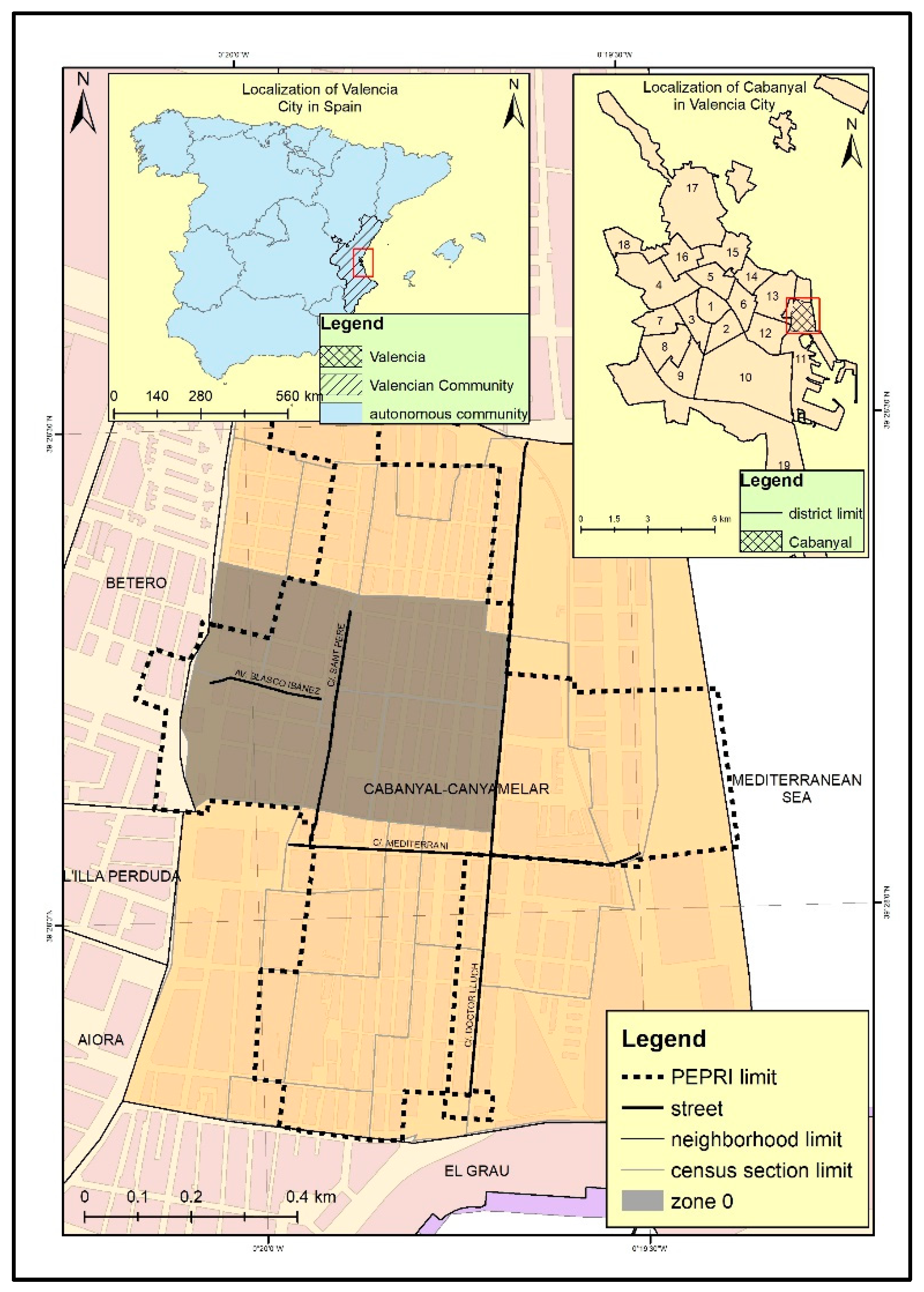
This project has a long history, which began in 1931, but its most recent history started in 1988, when it was included in the General Urban Zoning Plan of 1988. This project aimed to construct a connection between the City of Valencia and the beach, which would mean the division of the historical location into two different parts and the destruction of 1651 houses and two symbolic buildings in the old town [26]. As a response against the municipal plans and with a view to protecting the neighborhood, considered an historical location by its patrimony in popular architecture, the regional government declared it in 1993 as an Asset of Cultural Interest, thus resulting in the paralysis of the project. Despite this, the City Council developed and approved in 2001 a Special Plan for Protection and Interior Reform (PEPRI) of the Cabanyal-Canyamelar neighborhood, which maintained the extension of the avenue to the beaches, although of a somewhat smaller width (48 m), which would mean the demolition of 575 properties (see Figure 1). This decision was met with strong opposition and the emergence of a citizen movement that, with the slogan “Salvem el Cabanyal”, confronted the project head-on and even went so far as to obtain the declaration of “cultural plunder” by the Spanish Ministry of Culture in 2009. This aimed to stop the plans of PEPRI from being executed, as well as to reverse the suspension made by the City Council of Valencia of granting rehabilitation licenses in the affected area until this decision had been resolved. Meanwhile, the Council continued with the process of public acquisition and demolition of homes.
The uncertainty associated to this decision led to a strong retreat of private investment in the construction and rehabilitation of housing. This, together with the limitations in the granting of municipal works licenses, in a process that was considered real estate mobbing by the resident population, is one of the main causes for the physical degradation of the area, potentially affected by the extension. According to the Citizen Platform Salvem el Cabanyal, “the methods of the City Council and associated companies is to reach specific agreements with the neighbors to acquire the properties. Once acquired, these buildings are demolished to leave open lots, or are rented to a marginal population, or left in a state of abandonment. In this way the neighborhood is degraded” [27]. Furthermore, the Strategy of Sustainable Urban Development created for the neighborhood in 2015, states that the aforementioned real estate mobbing would be responsible for the current situation, characterized by the deterioration of buildings and public spaces, the forced sale of property to the administration, the irregular occupation of numerous buildings, the abandonment of the neighborhood by its native population and its replacement by a population at risk of exclusion, the disappearance of productive activity, and a strong deterioration of the coexistence and the image of the neighborhood both internally and in the city [28]. According to the same source, in 2015, 10% of the neighborhood plots were empty lots (128 of them public property), and 11% had abandoned or dilapidated homes (368 of them public property).
This stage of uncertainty ended when, after the political change experienced after the 2015 elections, the new municipal government decided to abandon the idea of extension and instead opted for the rehabilitation and regeneration of the neighborhood, starting in 2017 the project Va Cabañal! which promised regeneration, revitalization and urban restructuring. However, as will be observed later, the results to date are still not evident.
Hence, the uncertainty regarding the future of the Cabanyal neighborhood has contributed to its classification by the Ministry of Development as a vulnerable neighborhood from 1991, a period when only two other neighborhoods in the city were considered vulnerable, until 2011, when the number of vulnerable neighborhoods ascends to 39. It is registered among the neighborhoods with greater socio-economic and residential vulnerability, with an increase in criminal incidences and a small surface area of green spaces [29]. On the other hand, a study conducted by the City Hall of Valencia for the year 2015 places the Cabanyal neighborhood among the potentially vulnerable neighborhoods, with major socio-economic vulnerability and average values in terms of indicators related to demographic and equipment vulnerability. Among its main problems, compared to other neighborhoods of the city, there can be mentioned: restricted accessibility to health services and social services centers, lack of green areas, an ageing population, predominance of a population with a low level of education and lack of tourist services [30]. It should also be noted that the district of Poblados Marítimos, which is included in the study, remained during the period 2001–2011 among the urban areas at a low economic level, characterized by high unemployment rates, a large proportion of non-EU immigrants, a high level of illiteracy among the population and small, poorly-equipped homes [31].
In this article we study the process of residential changes which the Cabanyal neighborhood of Valencia City has experienced during the last decade, a process that has resulted in the constitution of a strongly segregated space owing to the impact of the extension project and its posterior paralysis on the area. We start from the hypothesis that the launch of the project, economically-focused and without consideration for the social and territorial variables, together with the lack of local government action when social resistance and protection regulations paralyzed it, has generated in the area directly affected by the project (what we call zone 0) a series of demographic changes. These include the breaking up of the existing social structure and the consequent formation of a socially conflictive space which has proved difficult to recover by incipient regeneration plans.
The next section will include the objectives and the methodology. Afterwards, we will present the results, describing the demographic dynamics of the neighborhood, the changes in the composition of migration and the profile of the immigrants. Finally, our conclusion will highlight the main elements identified during the research.
2. Materials and Methods
The purpose of this paper is to conduct a research of the demographic dynamics and residential changes that have taken place in the Cabanyal neighborhood, in order to identify to what extent the extension project of Blasco Ibáñez Avenue has contributed to the increase in segregation and physical and social degradation of the neighborhood. In order to do this, we used microdata from the Residential Variations Statistics provided by the Statistical Office of Valencia City over the period 2004–2016, which contain information about sex, age (under 16 years old, between 16 and 25, 25 and 45, 45 and 65, inclusively, and greater than 65 years old), and nationality of the migrant (Spanish, EU resident, non-EU resident). For the 2014–2016 period, details concerning the level of education are also provided: under 18 years old; they do not know how to read or write; lower degree to secondary school level; secondary school level or equivalent; Bachelor, FP second degree or equivalent or higher degrees. The residential variations are registered through seven types of movements: inputs based on immigration, inputs based on childbirths, inputs based on other reasons, outputs based on emigration, outputs based on deaths, outputs based on other reasons and changes of address, but for the present investigation, only the data related to immigration, emigration and the changes of residence were used. These data include the number of movements that correspond to common characteristics at the census tract, and indicate, in addition to the demographic profile of the migrant, the census section of origin (for the inputs) and destination (for the outputs).
In order to highlight the disparities that characterize the Cabanyal neighborhood, we have divided the study area into two sectors: the first one corresponds to “zone 0”, the most degraded part, directly affected by the extension project (although zone 0 corresponds to a part of several census sections, due to the restrictions of the date source used, we have incorporated in the study the complete sections, so that the zone 0 includes five census sections: 21, 22, 24, 26, and 27; the other 14 census sections that make up the neighborhood are included in the second analysis sector) and the second one includes the rest of the neighborhood (see Figure 1). Regarding the places of origin and destination of the movements, these have been grouped into seven categories:
- -
- Abroad
- -
- The rest of Spain, which includes municipalities outside the Valencian Community
- -
- The rest of the Valencian Community (CV), which includes the municipalities of the region (NUTS 2), outside the Metropolitan Area of Valencia
- -
- -
- City of Valencia, which includes the districts of the city, except for the district to which the neighborhood belongs
- -
- Poblados Marítimos District, which includes movements with origin or destination in neighboring neighborhoods
- -
- The Cabanyal neighborhood, which includes internal movements, between census sections of the neighborhood
For each of the mentioned sections, the following have been calculated: the total of the inputs, the total of the outputs, the total migratory balance and the migratory balance according to the demographic profile of the persons who change their residence. We have also calculated annual rates of immigration, emigration, and balance, taking as reference the population of the census corresponding to the first year of the period under analysis. Since the period under analysis has been marked by several events with strong impact in the study area, we have decided to divide it into four intervals: 2004–2007, prior to the economic and social crisis, characterized by the massive influx of immigrant population; 2008–2009, interval included between the time of the beginning of the crisis and the moment of suspension, by the municipality, of the rehabilitation and construction licenses, which accelerates the process of physical and social degradation of the neighborhood; 2010–2013, a period of economic crisis, of strong changes in migration trends and 2014–2016, a period of slow revitalization after the crisis and changes in the territorial policies of Cabanyal.
3. Results
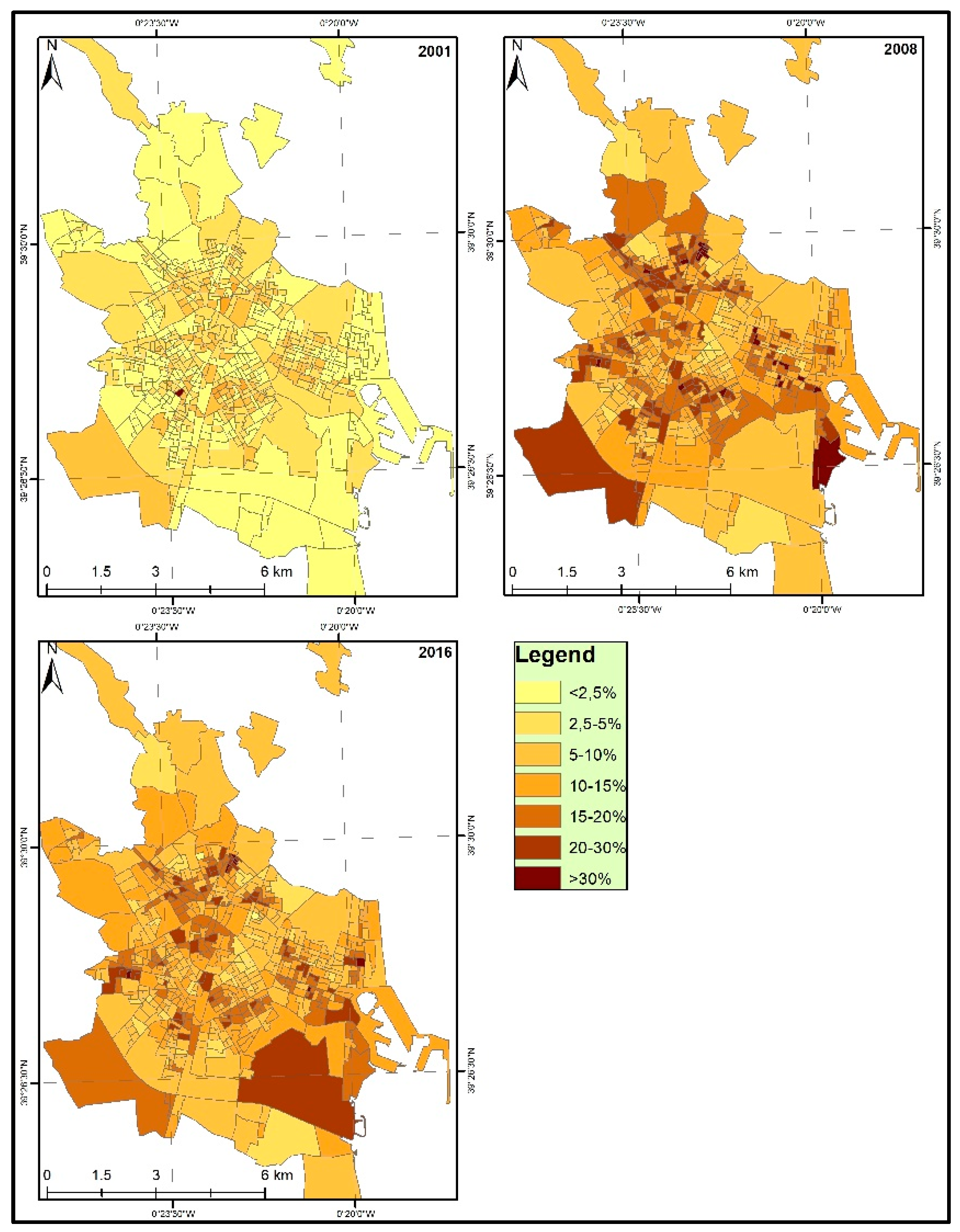
Valencia City was characterized, over the period from 2001–2016, by a process of population growth, interrupted only in the period 2008–2013 due to the economic crisis. The demographic growth was largely due to the increase in the immigrant population, whose percentage in the total population has registered in this period a rise of 10%, the maximum value corresponding to 2009, the year which marked the beginning of the economic crisis (15.06%). If at the beginning of the period only in one section of the Patraix neighborhood the number of immigrants exceeds 30%, in 2008 the number of sections with this characteristic ascends to 21 and in 2016 declines to 16. We can also observe that at the end of the period the immigrant population begin to be distributed throughout the entire territory, with peripheral districts gaining in importance (Figure 2).
In order to provide a better understanding of the situation of the Cabanyal neighborhood and zone 0 at a regional and national level, Table 1 offers a general image of some indicators regarding the population structure. In 2016, it can be noticed that zone 0 registered a higher number of immigrants compared to the ones registered in Spain, Valencia and even the neighborhood of Cabanyal. Furthermore, during the period corresponding to the project development, it registered the highest increase in terms of immigrants’ percentage and also the greatest loss in Spanish population. Moreover, even when the proportion of the elderly was diminishing, it still remained higher in the Cabanyal neighborhood (see Table 1).
The Cabanyal neighborhood, similar to all the components of the City of Valencia, is characterized by a general trend of demographic growth, interrupted only in short periods. A fundamental difference when compared to the trends registered in Valencia City and in the rest of the Poblados Marítimos district, is the relative delay in the display of the consequences of the economic crisis, given the fact that the greatest loss in population in the neighborhood corresponds to the period 2013–2016, due to a decrease in the migratory balance that occurs when the city and district already begin to recover. This population growth occurs in parallel with an intense process of population substitution, as we will see in the following paragraphs.
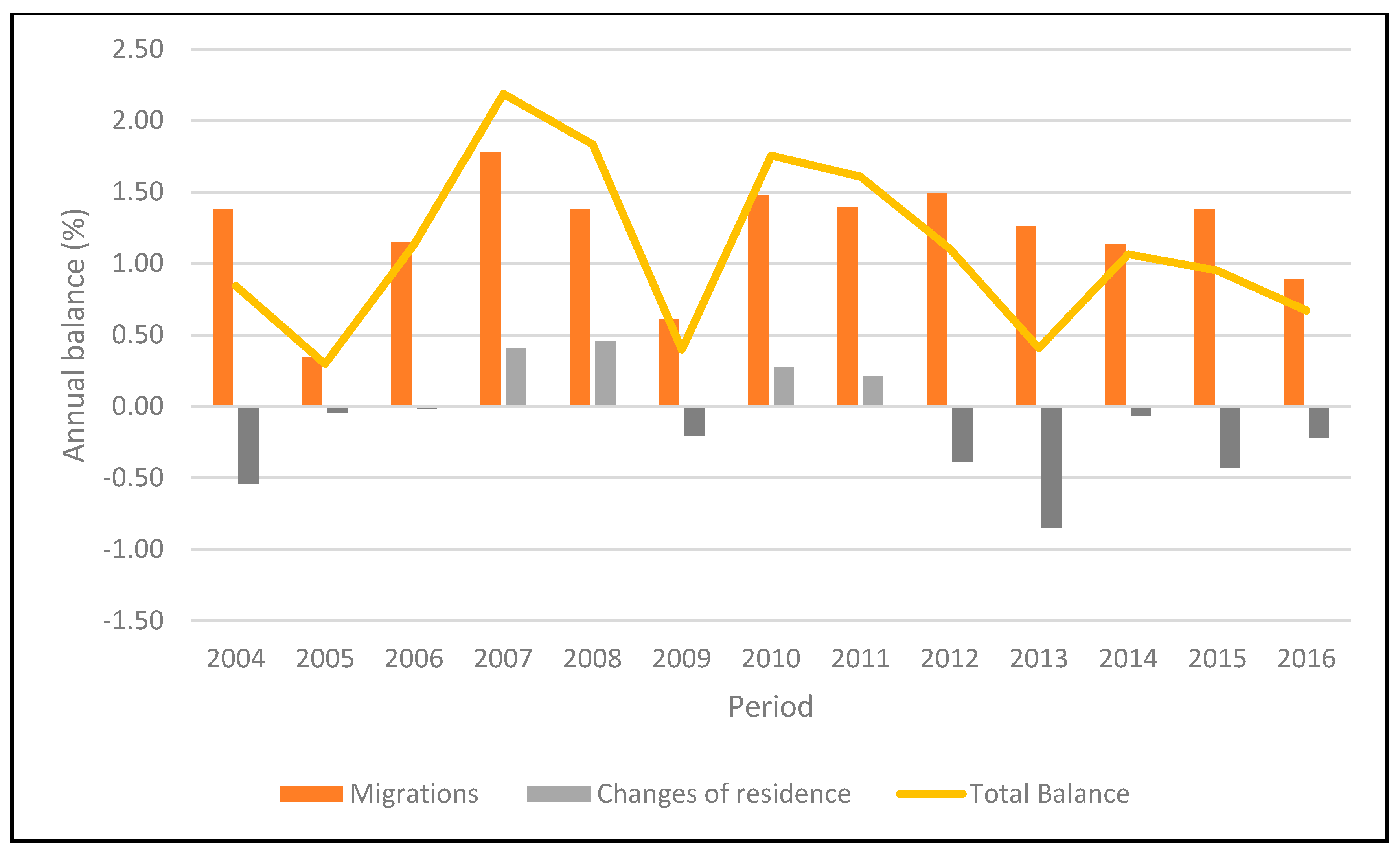
During the whole period under analysis, the migration balance of the Cabanyal neighborhood was always positive, with an alternating evolution from one year to another. To explain this result, of positive migratory balance, there are some facts, especially the movements originated from outside of Valencia City, while the changes of residence, related to internal movements, have generally experienced a negative balance or very low values (Figure 3). Therefore, we are witnessing a substitution of the local population, that leaves the neighborhood due to its problems, with a new population, recently arrived, that is in a phase of searching for cheap housing.
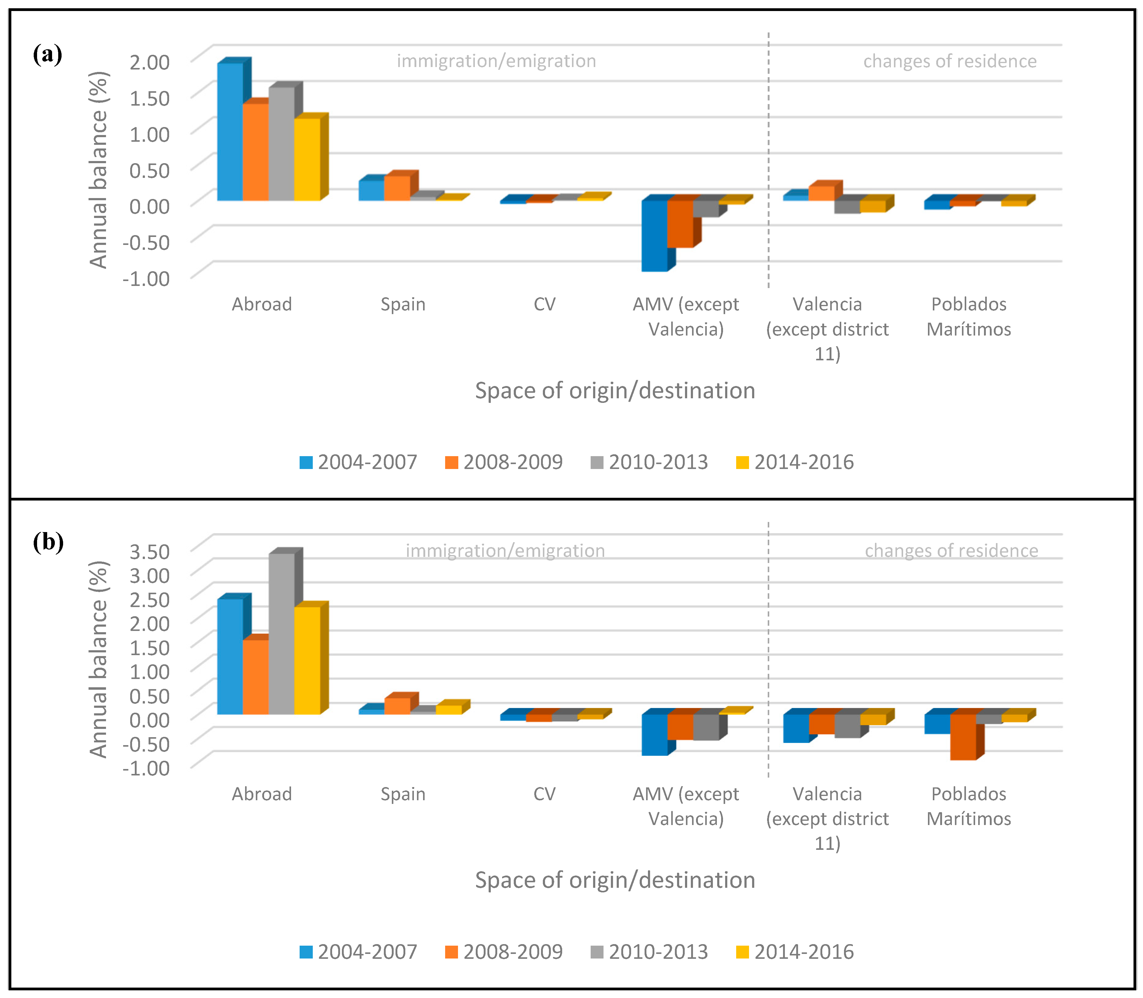
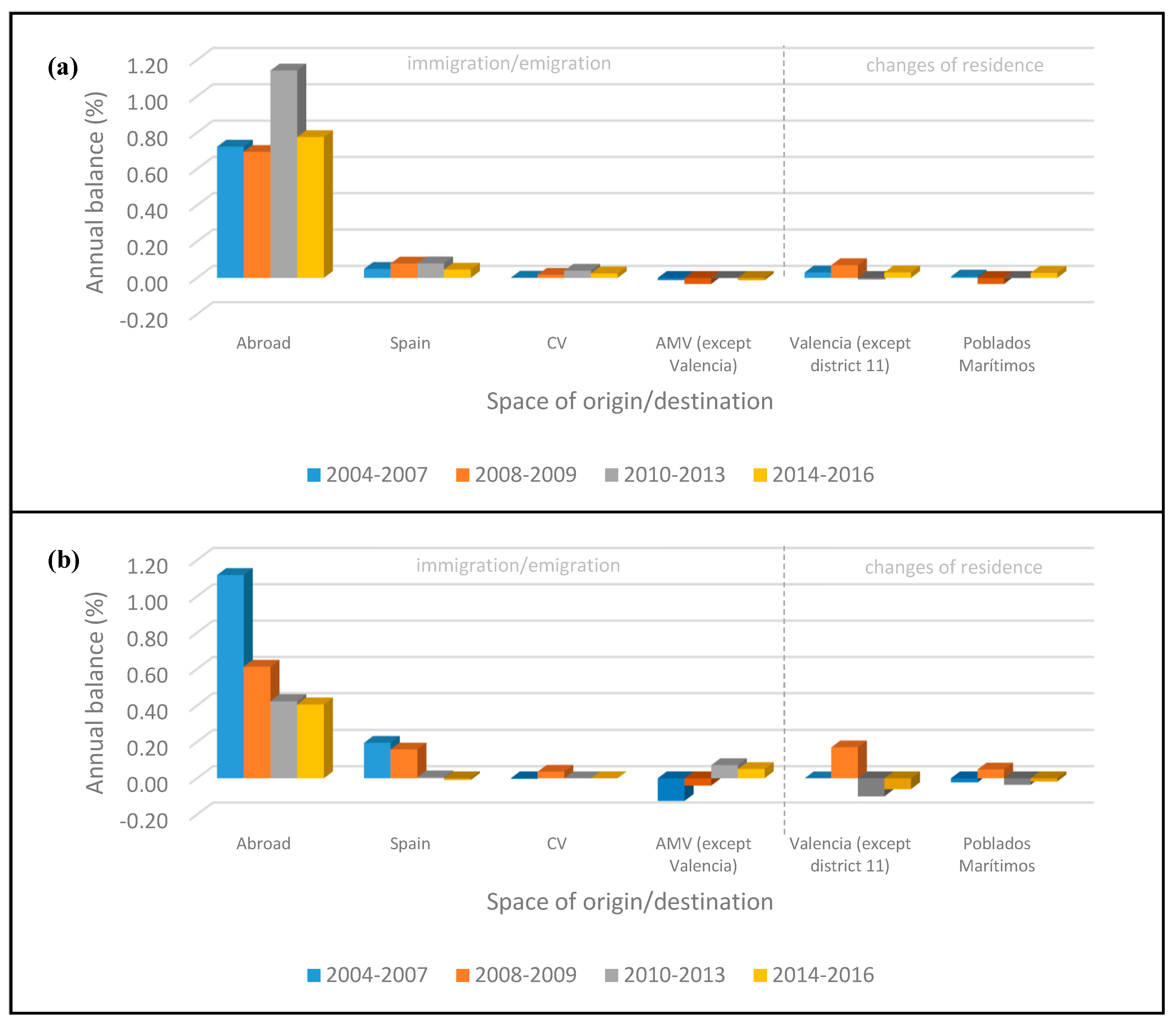
With regards to the spaces of origin and destination, most of the arrivals are made up of a foreign population, while the departures consist of a population which is oriented towards towns in the Metropolitan Area of Valencia. In terms of population movements in the area of the City of Valencia, it is worth mentioning the change in orientation that occurs with the economic crisis, so that, while Cabanyal receives population from the rest of the city before the crisis, after that, it begins to lose its population in favor of the rest of the neighborhoods in the city (Figure 4a).
This geographic pattern is related to the sociodemographic profile of the population that moves. In effect, during the period under analysis, the neighborhood continuously lost Spanish population, while it gained immigrant population, so that the proportion of foreigners reaches almost 15% of the total in 2016 (the maximum value, 15.19%, was registered in 2013). The continuous loss in Spanish population is progressively reduced, with the largest negative balances corresponding to the 2004–2007 interval (−0.86%/year).
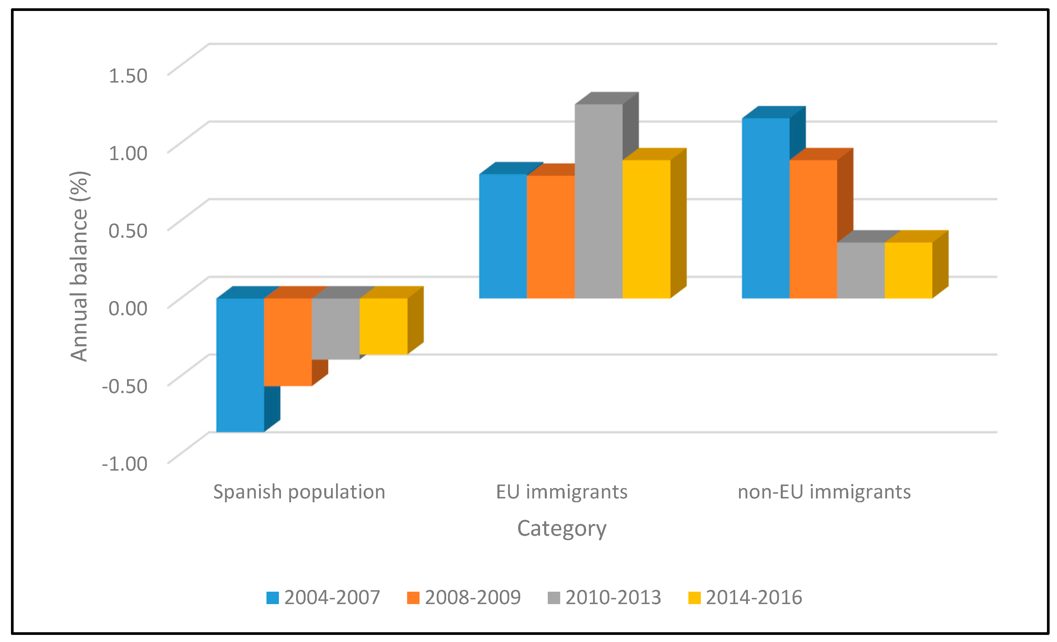
In addition, throughout the studied period we also observe a fundamental change in the composition of this immigration. The migration analysis according to nationality shows strong discrepancies between the migratory behavior of Spaniards, of EU migrants and of non-EU migrants. As can be observed in Figure 5, there is not only a loss in Spanish population, but also a substitution of non-EU immigrants, who form the majority during the 2004–2009 interval, with immigrants from the EU, who predominate during the 2010–2016 period. Consequently, while in 2006 the non-EU immigrants born in Colombia (14.01%) and Ecuador (11.72%) predominate in the composition of the population, in 2016, Romanians represent almost half of the population born outside Spain (42.44%). The process of substituting non-EU immigration with EU immigration is notably more intense than in the rest of the City of Valencia. Thus, while in the City of Valencia the percentage of the Romanian population over the total number of immigrants in 2016 was 12.83%, in the neighborhood it exceeded 40%. Even though in Valencia there were also other neighborhoods with high percentages of immigrants, in Cabanyal, the problem was exacerbated by the degradation of the neighborhood and the attitude of the local authorities towards it. As a result, there exists a stronger negative perception towards the Romanian population in Cabanyal, due to the fact that they are considered a part of the political strategy for demolishing the neighborhood and for putting pressure on the local population to leave the neighborhood. There is also competition between Romanians and the local population for resources, specifically jobs, social assistance and aid which, in this neighborhood, is more emphasized due to the general situation. Furthermore, taking into consideration that they are the last immigrants to arrive in the neighborhood, they have no representatives or leaders in the community, which again contributes to their segregation and abandonment (Source: interviews developed in the neighborhood).
This change in the composition of the immigrant population has important consequences in the field of segregation. A fundamental difference between EU and non-EU immigrants is their contact with the neighborhood and the degree of stability. For EU immigrants, Cabanyal is their first contact with Spain, the neighborhood corresponding to their first settlement in this country. On the other hand, non-EU immigrants settle initially in other neighborhoods of the city and then choose Cabanyal as their second or third destination. In addition, EU immigrants settle in the neighborhood and tend to stay there, with few departures to other neighborhoods or towns. Conversely, non-EU immigrants show a higher mobility, not only because Cabanyal is not the first settlement destination, but also because, after a while, many of them go to other neighborhoods or other towns in the metropolitan area (see Figure 6a,b). One drawback of the analyzed data is the division of nationalities into only these three categories, which do not allow us to distinguish between North Americans, Latin Americans, Africans (for non-EU immigrants), or those from Western Europe, from Central Europe, or from Eastern Europe (for the EU immigrants). However, the census data allow us to observe that among the non-EU immigrants, Latin Americans predominate and among the EU immigrants those from Eastern Europe form the majority. This could justify the choice of both settlements: the Cabanyal neighborhood for its cheap housing, but also the city with its accessibility to various services.
According to other demographic aspects, the composition of the migration indicates a greater number of arrivals by members of the male population than the female population. According to age, there is a continuous loss in the over-65 population, while, at the same time the 25–44 population, which represents the working age, is seen to be entering the neighborhood. In the period of economic crisis in the neighborhood, families also enter, this fact being confirmed by the increase in the under-16 population.
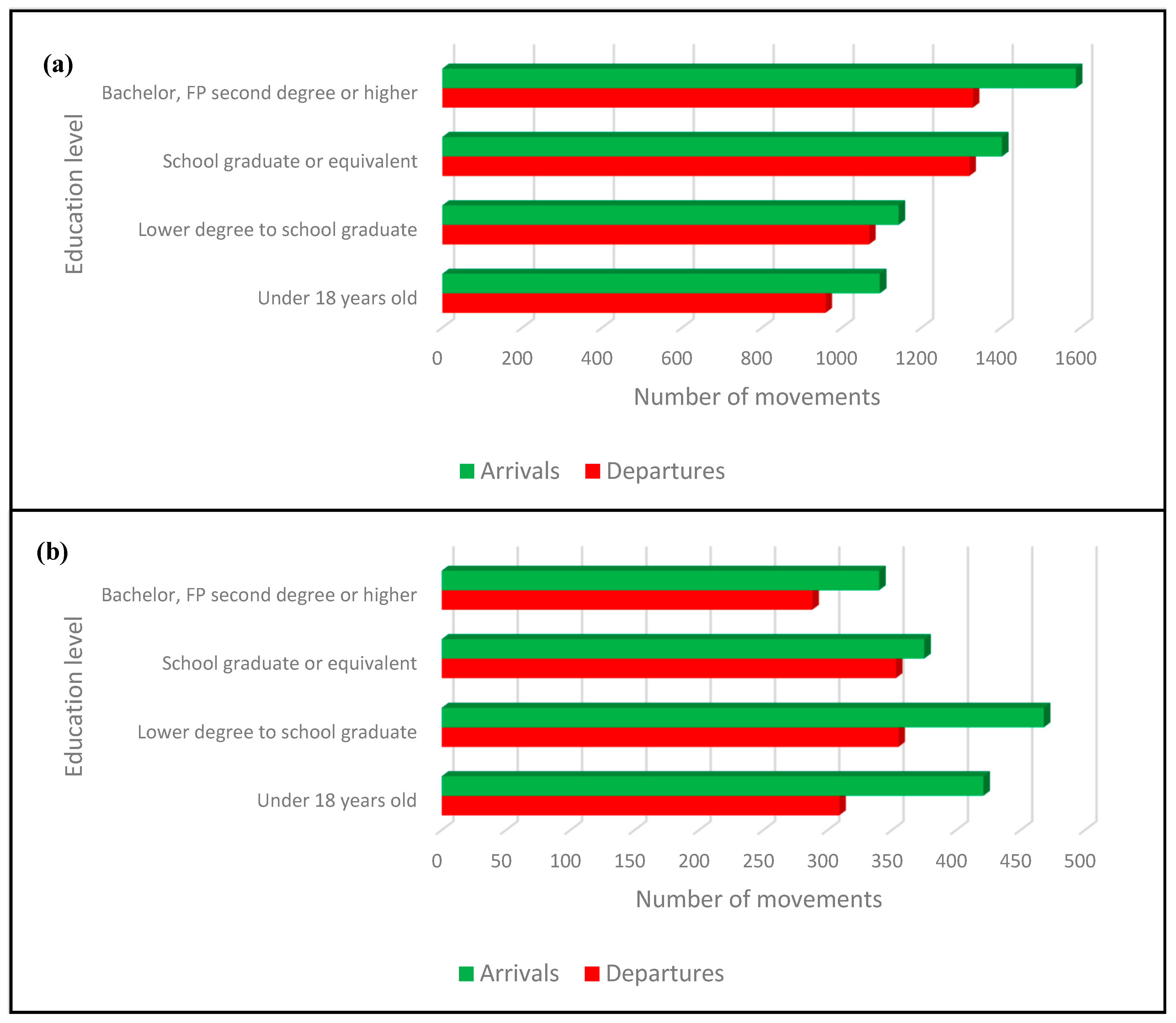
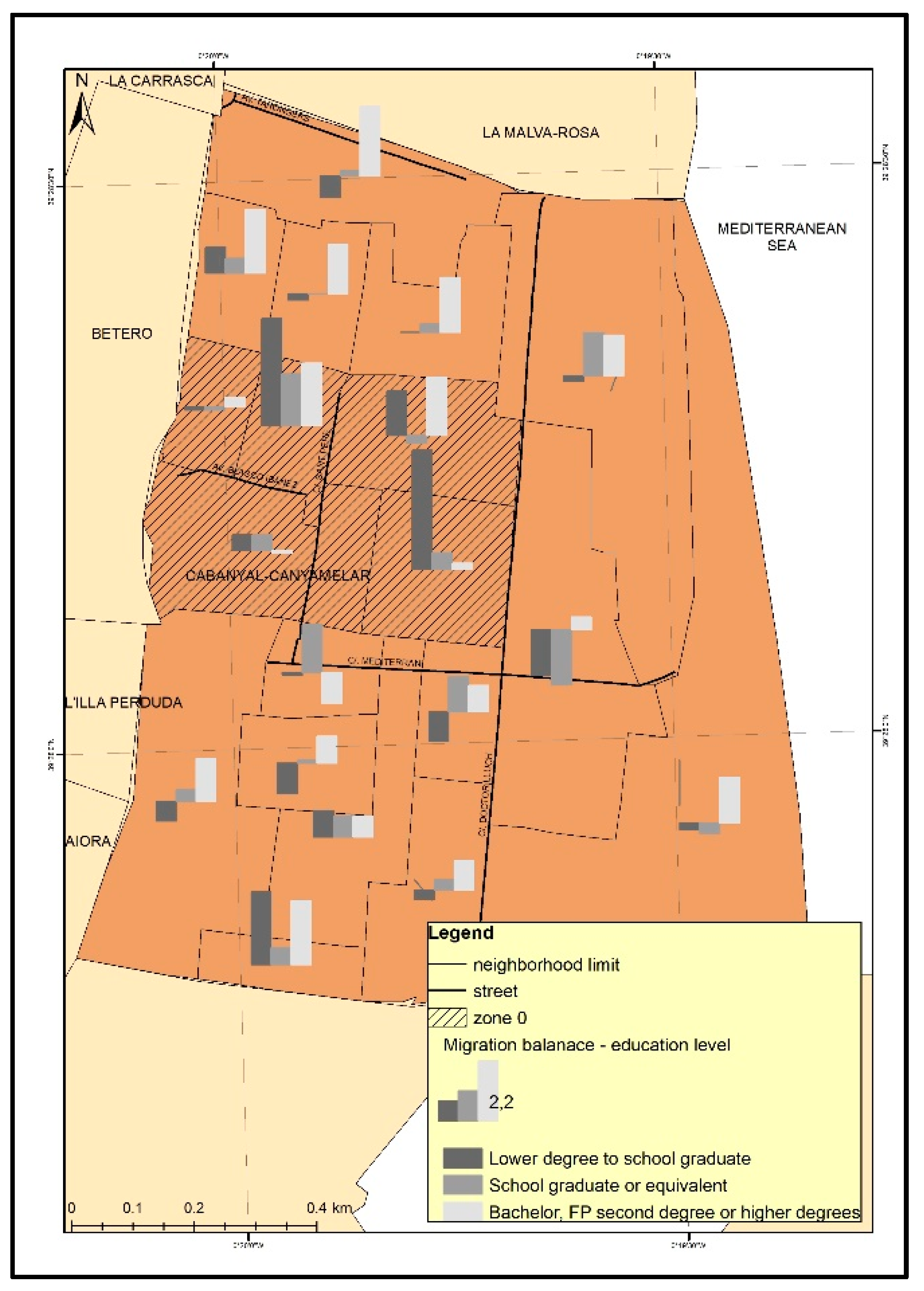
To demonstrate this point further, the available data allow us to analyze the mobility in the Cabanyal neighborhood according to the level of education only from the period 2014–2016, a period of reinvigoration after the economic crisis. An important fact to be highlighted regarding the level of education is the differences that it shows according to nationality. Regarding this, the major difference is that the EU immigrants are associated, based on the statistical data, to the population with a low level of education that comes to the neighborhood, while the non-EU immigrants have at least a secondary education level or equivalent or high level of education. Spanish migrants that come to the neighborhood are similar to non-EU immigrants based on these categories relating to levels of education, but the percentages are higher.
Although the period is quite reduced, a trend of social renewal of the neighborhood can be observed, which sees an increase in members of the population with a Bachelor’s or other high level of education, but also in the under-18 population, which indicates the settlement of families (Figure 7a).
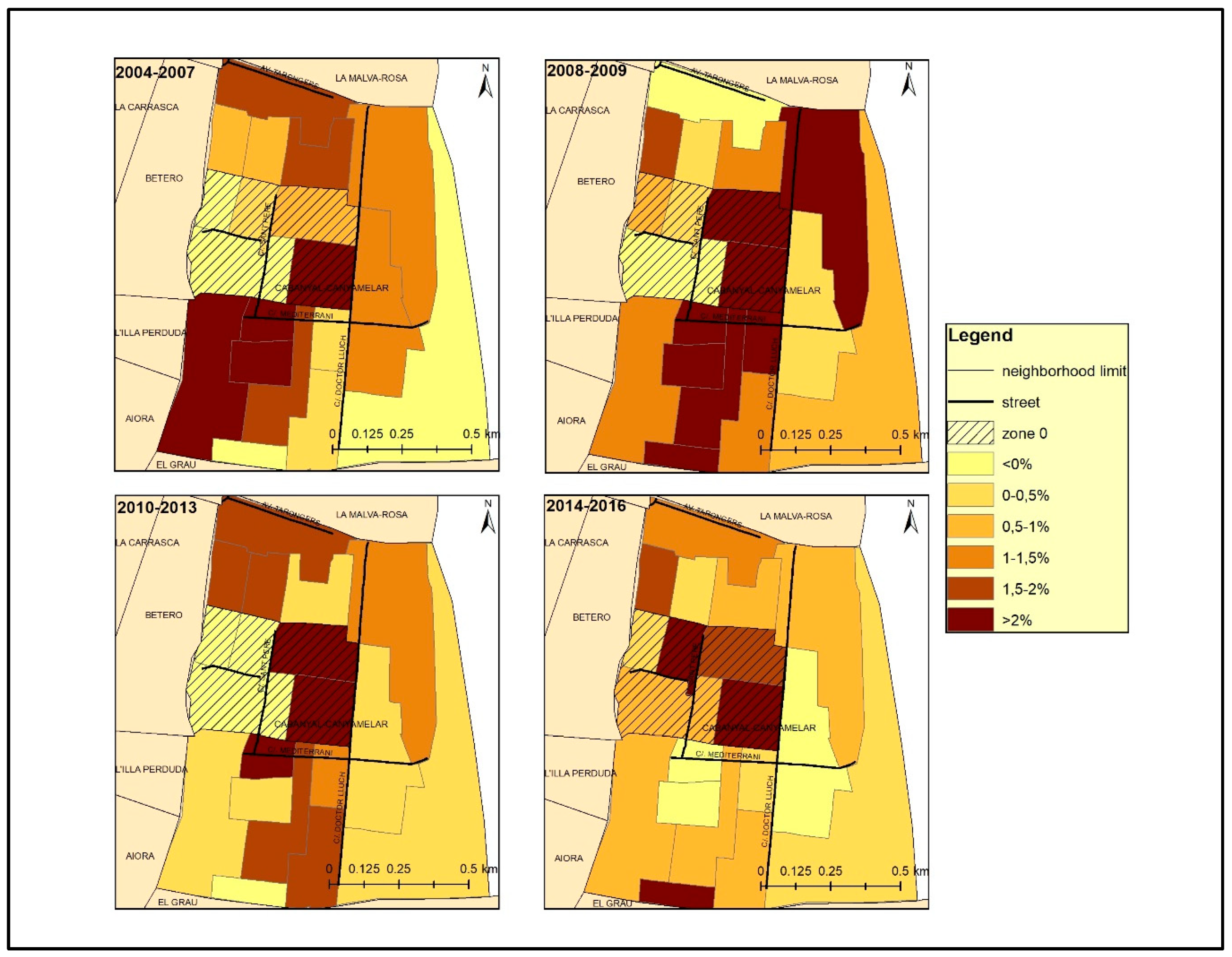
In this context, the impact of the project can be observed when we analyze these processes at a more detailed level. Indeed, zone 0 shows a different behavior, since the impact of the extension project of Blasco Ibáñez Avenue generates a regressive dynamic in the affected sections. Firstly, while the demographic balance of the neighborhood as a whole is, as we have already said before, positive, zone 0 registers a continuous loss in population until 2013. The contrasts existing in the neighborhood are evident on the map (see Figure 8), especially in the surroundings of zone 0, where there are neighboring sections with minimum and maximum values of demographic balance.
Secondly, and regarding the spaces of origin, the positive balance of the movements originating from abroad is significantly greater in zone 0 than the one registered in Cabanyal neighborhood as a whole (see Figure 4a,b). In this area, there are also recorded arrivals of migrants from the rest of Spain, although to a lesser extent. On the other hand, the majority of those who leave zone 0 of the neighborhood are directed, in the initial period (2004–2007), towards the towns of the metropolitan area and, subsequently, to the rest of Poblados Marítimos district and other neighborhoods of the city. It is especially significant that during the period between 2008 and 2009, corresponding to the suspension of the rehabilitation and construction licenses in the neighborhood by the municipality, the greatest number of population outflow is directed towards the neighboring residential areas of the Poblados Marítimos district, which indicates the repercussions that this action had on the population of the neighborhood (see Figure 4b).
The three categories of nationalities show a markedly different attitude towards zone 0: the Spanish population avoids this sector, leading to a greater number of departures; the non-EU population chooses this sector in the period 2004–2007, but then the sector becomes neutral according to their preferences (migratory balances near the value 0); for immigrants from the EU, zone 0 becomes a preferred space from the period 2010–2016. Therefore, EU immigrants have a greater tendency for segregation, since they are concentrated in well-defined spaces (after the crisis they choose even the most degraded ones), establishing few relations with the other residents.
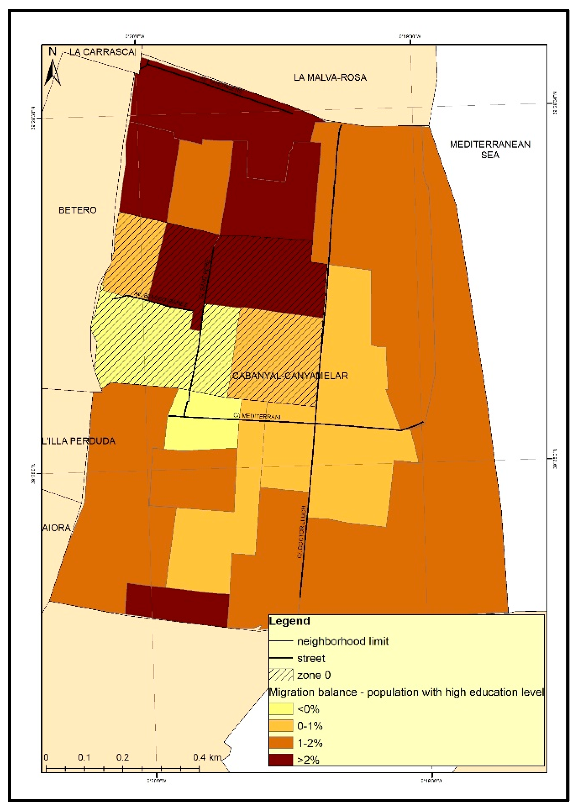
Finally, if we take into consideration the educational level of the population that changes its residence, zone 0, due to its advanced state of degradation, is characterized by a completely different situation compared to the whole neighborhood. In the period between 2014 and 2016, the economic recovery phase, most of the neighborhood lost members of its population who had less than a secondary education and gained a population with a higher education level, evidencing, as previously stated, a social revitalization. Zone 0 demonstrates the inverse behavior through the registering of the highest value of the migration balance for the population with a low education level, while the population with a higher level of education either decreases or does not register any significant changes. Figure 9 and Figure 10 clearly show the contrast between the gentrification processes that affect certain sectors of the neighborhood in this phase of economic recovery, particularly the northwest sector, but also, with lower intensity, the southwest area and the maritime strip, and the concentration of population with fewer resources in the area affected by the extension project.
Based on our analysis, we can conclude that the extension project of Blasco Ibáñez Avenue affected the neighborhood to a great extent. Basically, there were three phases of the project: the initial project of extension, the paralysis of the local government’s actions and the current re-urbanization project, each phase being identified by different types of consequences. The initial phase was the one that introduced the main changes in the social structure of the neighborhood, causing, thus, a break in the pre-existent social structure, by compelling the Spanish population to leave the neighborhood and favoring the settlement of immigrants in abandoned house. The second phase, characterized by the paralysis of the local government’s actions, is characterized by the conversion of zone 0 in the home of the immigrants from the European Union. This means a change of population that adds to the physical degradation of the neighborhood also the increase in segregation level. The last phase, that started in 2015, is a period of new opportunities and expectations, but related mostly to the neighborhood, not to the zone 0. The neighborhood has been affected in this period by a gentrification process, which seems to generate another social conflict, since housing and rent prices are rising, forcing the Spanish population that managed to cope during the difficult periods of the extension project to once again leave the neighborhood in favor of tourism development. Furthermore, for the moment, this process seems to affect only the Spanish population, not the immigrants that settled in the neighborhood in the previous years, due to the fact that zone 0 is not yet included in the process.
4. Discussion and Conclusions
According to our results, in the study area, we can observe the negative effects that have been pointed out by different authors as a consequence of project planning that aims to improve the image and global positioning of the city without previous reflection on the social consequences. That is, the displacement and marginalization of the local population [13] and the confrontation between the interests of the community and the project’s objectives [12] that generates an important social response [14] and leads to polarization and social fragmentation [10]. The dynamics of segregation and gentrification thus created lead to a greater fragmentation of the urban space. This paper constitutes an empirical contribution to the knowledge of the way in which these processes are produced in a specific space. In particular, it shows how not only the continuous action of the administration, but also its lack of action can lead to a situation of deterioration difficult to reverse, which once catalyzed the process of marginalization in the urban space. Although the Cabanyal neighborhood has been affected by other general processes, such as the economic crisis and the massive influx of immigrants, the specific impact of the project in the generation of this dynamic is evident through the observations into the different evolutionary processes between the area directly affected by the extension of the avenue and the surrounding areas.
The Spanish state has been affected by a massive influx of immigrants since the end of the 20th century, a tendency that continues into the current period. This phenomenon is relatively new in Spain if we compare it with other European countries, and, in this context, the country has had to adapt very quickly to these new trends, without having enough time to assimilate the new process that was characterizing it. This situation was observed with greater intensity in the large cities, which constituted poles of attraction for the immigrant population. Therefore, Valencia also followed these trends and received a large number of immigrants in a relatively short period of time. The migration dynamics, along with political decisions and the economic crisis, have had a strong impact on the territory and on the population, concerning coexistence and lifestyle. In addition, the economic crisis was one of the most important temporary nodes, which have determined on one hand changes of tendencies and on the other hand an increase in the existing trends.
The Cabanyal neighborhood is an example of the interaction of both factors, but also of the consequences of an urban policy focused on economic interests that paid little attention to social issues. In the period between 2004 and 2016 its number of immigrants has increased due not only to the migratory dynamics that characterized the entire city, but also to the situation in which it is after the paralysis of the extension project of Blasco Ibañez Avenue. However, the migratory dynamics did not have the same tendencies during the whole period, but it was characterized by different trajectories of evolution according to the temporality of the project.
In this context, the Cabanyal neighborhood lost part of its Spanish population especially through residential mobility, while it received a foreign population in return. If the loss in the Spanish population is continuous, the EU and non-EU population entries are identified by different guidelines in each period. In the period 2004–2007, the non-EU population was clearly the majority among the immigrant population, but in the period 2008–2009 the balance of the EU and non-EU population tends to be similar. The period 2010–2013, corresponding to the real estate, economic, and social crises, is the one that introduces the greatest changes, as it determines the reversal between the two categories of immigrants. After this interval, the EU immigrants become predominant, replacing, to a large extent, the non-EU immigrants.
The weight of the project in the generation of this dynamic is evident when we consider the different ways in which the area directly affected by the extension of the avenue evolved along with the surrounding areas. Thus, during our analysis we observed in zone 0 not only the greatest loss in Spanish population from the whole neighborhood or the greatest increase in the percentage of immigrants, but also a change in the social structure of the population in terms of education level, due to the area being populated by immigrants with a low level of education. Furthermore, this area is the most degraded in the neighborhood, owing to the expected extension of Blasco Ibañez Avenue, which made it a strategical place for change. That is why, for the moment, even though the regeneration process has started in the neighborhood, in this area the consequences of the project and the social problems caused can still be observed: degraded buildings or walled houses, abandoned places, poverty, litter, drug trafficking, etc.
In this context, the extension project of Blasco Ibañez Avenue has contributed to the increase in segregation, by encouraging the settlement of social groups with more obvious segregation dynamics. The main problem here is not, however, the settlement of a certain social group, but the fact that they live in very deteriorated housing conditions, without basic installations and utilities. They also have a low level of education and low-skilled and poorly paid jobs and this situation makes their social integration even more difficult. This process was not spontaneous, it was encouraged by local authorities, who, by their own efforts, allowed and contributed to the physical degradation of the neighborhood.
Cabanyal became, therefore, an attractive space for the immigrants coming from the European Union, especially for those from Eastern Europe with few economic resources. The non-EU immigrants, mostly from Latin America, with similar linguistic and cultural characteristics to the Spaniards, were replaced by the EU immigrants, admittedly closer from a geographical point of view, but with a different culture and lifestyle. Based on this settlement of people with different customs and traditions, who maintain few social relations with the local population, there is a tendency of increasing social segregation through the tracing of a perceptible boundary in the territory.
The dynamics of residential changes in the area during the recent years indicate that the processes of residential segregation have created a strong social inertia and resistance towards the urban revitalization policies implemented by the new municipal government. The case studied here illustrates how unwise public action can sharpen the tendency towards the formation of highly focused territorial inequalities in the urban areas, inequalities that are very difficult to reverse later, even in favorable circumstances characterized by economic recovery and the implementation of urban revitalization strategies. The main lesson on urban public policies that this case study provides us with is the importance of incorporating the analysis of social factors and community life in the neighborhoods in intervention projects as one of its most relevant aspects ahead of architectural aspects or the creation of an “urban scene”. The challenge that the new managers of the city are facing is how to intervene and promote regeneration without causing additional problems in an area that, as we have seen, currently suffers from strong contrasts in sociodemographic dynamics.
Thus, the current government’s responsibility is quite demanding, as it has to resolve an enduring problem, but without sparking off another social conflict and movement. It has to facilitate the immigrants’ social integration, by improving the quality of the buildings, but without transforming the neighborhood into a tourist one. It must, therefore, create a balance which ensures that the neighborhood’s attraction and specific lifestyle is not lost. According to the interviews made with members of the neighborhood, this is now one of the greatest fears of the local population: that the neighborhood will lose the distinctive features that they wanted to preserve, due to cohabiting with people who lack a sense of inclusion.
Consequently, public intervention should not be limited to the physical recovery of the neighborhood but should also be proactive in its social and economic rehabilitation. For this purpose, it currently has a public land patrimony acquired during the process, that would allow implementing public housing policies that favor the mix and reconstruction of the social structure, avoiding the risk of tourism gentrification in the neighborhood, that already seems forecast. In order to ensure this result, the process is dependent on the active group of local collectives created by the citizens’ initiative during the period of the conflict.
Author Contributions
Conceptualization: R.-D.I. and J.S.-C.; methodology: R.-D.I. and J.S.-C.; software: R.-D.I.; validation: R.-D.I. and J.S.-C.; formal analysis: R.-D.I.; investigation: R.-D.I. and J.S.-C.; resources: R.-D.I. and J.S.-C.; data curation: R.-D.I. and J.S.-C.; writing—original draft preparation: R.-D.I. and J.S.-C.; writing—review and editing: R.-D.I. and J.S.-C.; visualization: R.-D.I. and J.S.-C.; supervision: R.-D.I. and J.S.-C.; project administration: J.S.-C.; funding acquisition: J.S.-C.
Funding
This research was funded by Agencia Estatal de Investigación (AEI) and Fondo Europeo de Desarrollo Regional (FEDER) in the State Program for Research, Development and Innovation Oriented to the Challenges of Society, within the framework of the State Plan for Scientific and Technical Research and Innovation 2013–2016, call for 2016, within the framework of the project “Social Sustainability, Global Connectivity and creative economy as development strategies in the metropolitan area of Valencia” (CSO2016-74888-C4-1-R).
Acknowledgments
We would like to thank the Statistical Office of Valencia City for providing the microdata used in this study.
Conflicts of Interest
The authors declare no conflict of interest. The funders had no role in the design of the study; in the collection, analyses, or interpretation of data; in the writing of the manuscript; or in the decision to publish the results.
References
- Kwan, M.-P.; Schwanen, T. Geographies of Mobility. Ann. Am. Assoc. Geogr. 2016, 106, 243–256. [Google Scholar] [CrossRef]
- Coulton, C.; Theodos, B.; Turner, M.A. Residential Mobility and Neighborhood Change: Real Neighborhoods Under the Microscope. Cityscape 2012, 14, 55–89. [Google Scholar]
- Hasan, S.; Schneider, C.M.; Ukkusuri, S.V.; González, M.C. Spatiotemporal Patterns of Urban Human Mobility. J. Stat. Phys. 2013, 151, 304–318. [Google Scholar] [CrossRef]
- Kang, C.; Gao, S.; Lin, X.; Xiao, Y.; Yuan, Y.; Liu, Y.; Ma, X. Analyzing and geo-visualizing individual human mobility patterns using mobile call records. In Proceedings of the 2010 18th International Conference on Geoinformatics, Beijing, China, 18–20 June 2010; pp. 1–7. [Google Scholar]
- Eluru, N.; Sener, I.; Bhat, C.; Pendyala, R.; Axhausen, K. Understanding Residential Mobility. Transp. Res. Rec. J. Transp. Res. Board 2009, 2133, 64–74. [Google Scholar] [CrossRef]
- United Nations Millennium Development Goals. Available online: http://www.un.org/millenniumgoals/ (accessed on 6 February 2017).
- Rojo-Mendoza, F. La gentrificación en los estudios urbanos: Una exploración sobre la producción académica de las ciudades. Cadernos Metrópole 2016, 18, 697–719. [Google Scholar] [CrossRef]
- van Ham, M.; Tammaru, T. New perspectives on ethnic segregation over time and space. A domains approach. Urban Geogr. 2016, 37, 953–962. [Google Scholar] [CrossRef]
- Harvey, D. From Managerialism to Entrepreneurialism: The Transformation in Urban Governance in Late Capitalism. Geogr. Ann. Ser. B Hum. Geogr. 1989, 71, 3–17. [Google Scholar] [CrossRef]
- Swyngedouw, E.; Moulaert, F.; Rodriguez, A. Neoliberal Urbanization in Europe: Large–Scale Urban Development Projects and the New Urban Policy. Antipode 2002, 34, 542–577. [Google Scholar] [CrossRef]
- Díaz Orueta, F.; Fainstein, S.S. The New Mega-Projects: Genesis and Impacts. Int. J. Urban Reg. Res. 2008, 32, 759–767. [Google Scholar] [CrossRef]
- Trop, T. Social Impact Assessment of Rebuilding an Urban Neighborhood: A Case Study of a Demolition and Reconstruction Project in Petah Tikva, Israel. Sustainability 2017, 9, 1076. [Google Scholar] [CrossRef]
- Carrero, R.; Malvárez, G.; Navas, F.; Tejada, M. Negative impacts of abandoned urbanisation projects in the Spanish coast and its regulation in the Law. J. Coast. Res. 2009, 5, 1120–1124. [Google Scholar]
- Díaz Orueta, F. Madrid: Urban regeneration projects and social mobilization. Cities 2007, 24, 183–193. [Google Scholar] [CrossRef]
- Hall, C.M. Urban Entrepreneurship, Corporate Interests and Sports Mega-Events: The Thin Policies of Competitiveness within the Hard Outcomes of Neoliberalism. Sociol. Rev. 2006, 54, 59–70. [Google Scholar] [CrossRef]
- Pillay, U.; Bass, O. Mega-events as a Response to Poverty Reduction: The 2010 FIFA World Cup and its Urban Development Implications. Urban Forum 2008, 19, 329. [Google Scholar] [CrossRef]
- Romero, J.; Melo, C.; Brandis, D. The neoliberal approach to Valencia and Madrid. In Cities in Crisis. Socio-Spatial Impacts of the Economic Crisis in Southern European Cities; Knieling, J., Othengrafen, F., Eds.; Routledge: London, UK, 2016; pp. 73–93. ISBN 9781138850026. [Google Scholar]
- Observatorio Metropolitano. Paisajes Devastados. Después del ciclo Inmobiliario: Impactos Regionales y Urbanos de la Crisis; Traficantes de Sueños: Madrid, Spain, 2013; ISBN 9788496453807. [Google Scholar]
- Torres-Pérez, F. Nous Veïns a la Ciutat: Els Immigrants a València i Russafa; Publicacions de la Universitat de València: València, Spain, 2007; ISBN 978-84-370-6709-4. [Google Scholar]
- Pérez, F.T.; Montesinos, M.E.G. Crisis, Inmigración y Sociedad; Talasa: Madrid, Spain, 2015; ISBN 978-84-96266-46-9. [Google Scholar]
- Cucó-Giner, J. Metamorfosis Urbanas: Ciudades Españolas en la Dinámica Global; Icaria, Institut Català d’Antropologia: Barcelona, Spain, 2013; ISBN 978-84-9888-478-4. [Google Scholar]
- Salom-Carrasco, J.; Pitarch-Garrido, M.-D. Análisis del impacto en el turismo de la estrategia de desarrollo urbano basada en megaproyectos. El caso de la ciudad de Valencia. Cuadernos de Turismo 2017, 573–598. [Google Scholar] [CrossRef]
- Salom Carrasco, J.; Pitarch Garrido, M.D.; Albertos Puebla, J.M. Desired and undesired effects of the tourism development policy based on megaprojects: The case of Valencia (Spain). In Proceedings of the International Conference Building Urban Tourism through Place Making and Urban Regeneration in Central and Eastern European Countries, Timişoara, Romania, 19–20 May 2017. [Google Scholar]
- Cucó-Giner, J. La Ciudad Pervertida: Una Mirada Sobre la Valencia Global; Anthropos Editorial: Barcelona, Spain, 2013; ISBN 978-84-15260-74-5. [Google Scholar]
- Del Romero-Renau, L.; Trudelle, C. Mega Events and Urban Conflicts in Valencia, Spain: Contesting the New Urban Modernity. Urban Stud. Res. 2011, 2011. [Google Scholar] [CrossRef]
- Salvem el Cabanyal-Canyamelar-Cap de França | El Cabanyal es el Barrio Marinero de Valencia, España, Amenazado Desde el 24 de Julio de 1998 por un Proyecto de Prolongación de la Avenida Blasco Ibáñez que Partirá el Barrio en dos y que Supone la Destrucción de 1651 Viviendas. Available online: http://www.cabanyal.com/nou/?lang=en (accessed on 18 September 2017).
- Plataforma Salvem el Cabanyal, El PEPRI, un Plan de Reforma Interior sin Protección. Available online: http://www.cabanyal.com/nou/el-pepri-un-pla-de-reforma-interior-sense-proteccio/?lang=es (accessed on 1 November 2018).
- Ajuntament de Valencia. Estrategia de Desarrollo Urbano Sostenible e Integrado del Barrio Cabanyal-Canyamelar-Cap de França; Ajuntament de Valencia: Valencia, Spain, 2015; 217p. [Google Scholar]
- Portada Fomento | Ministerio de Fomento. Available online: https://www.fomento.es/ (accessed on 19 January 2018).
- Oficina de Estadística. Ayuntamiento de Valencia. Available online: http://www.valencia.es/ayuntamiento/catalogo.nsf/CatalogoUnTitulo?readForm&lang=1&serie=60&titulo=%C1reas%20vulnerables%20en%20la%20ciudad%20de%20Valencia%202016&bdOrigen=ayuntamiento/estadistica.nsf&idApoyo=58FB3C7A3D56E414C1257DD40057EB6C (accessed on 6 November 2017).
- Salom, J.; Fajardo, F. Cambios recientes en la estructura territorial sociodemográfica del área metropolitana de Valencia (2001–2011). Boletín de la Asociación de Geógrafos Españoles 2017. [Google Scholar] [CrossRef]
- Feria-Toribio, J.M. Un ensayo metodológico de definición de las áreas metropolitanas en España a partir de la variable residencia-trabajo. Investigaciones Geográficas 2008, 46, 49–68. [Google Scholar] [CrossRef] [Green Version]
- Instituto Nacional de Estadistica. (Spanish Statistical Office). Available online: http://www.ine.es/ (accessed on 26 September 2017).
- Portal Transparencia y Datos Abiertos Valencia. Available online: http://gobiernoabierto.valencia.es/es/ (accessed on 22 September 2017).
- Ilisei, R.-D. Mobility and segregation in Valencia City. Case study: Cabanyal neighborhood. Geogr. Timisiensis 2016, 25. Available online: https://geografie.uvt.ro/wp-content/uploads/2018/05/ilisei-format.pdf (accessed on 22 September 2017).

Figure 2.
Immigrants’ percentage in Valencia City, at census section level, 2001–2016.

Figure 3.
Migration balance in the Cabanyal neighborhood, 2004–2016.

Figure 4.
Total balance in Cabanyal (a) and in zone 0 (b) according to spaces of origin and destination, 2004–2016.
Figure 4.
Total balance in Cabanyal (a) and in zone 0 (b) according to spaces of origin and destination, 2004–2016.

Figure 5.
Migration balance according to nationality in Cabanyal, 2004–2016.

Figure 6.
Total balance of EU immigrants (a) and non-EU immigrants (b) in Cabanyal, according to spaces of origin and destination, 2004–2016.
Figure 6.
Total balance of EU immigrants (a) and non-EU immigrants (b) in Cabanyal, according to spaces of origin and destination, 2004–2016.

Figure 7.
Migration balance in Cabanyal (a) and zone 0 (b) based on education level, 2014–2016.

Figure 8.
Migration balance in Cabanyal and zone 0, 2004–2016 [35].
Figure 8.
Migration balance in Cabanyal and zone 0, 2004–2016 [35].

Figure 9.
Migration balance of population with high education level in Cabanyal and zone 0, 2014–2016.
Figure 9.
Migration balance of population with high education level in Cabanyal and zone 0, 2014–2016.

Figure 10.
Migration balance in Cabanyal and zone 0 based on education level, 2014–2016


Table 1.
Socioeconomic criteria in different analysis areas.
| Criteria | Spain | Valencia | Cabanyal | Zone 0 | ||||||||
|---|---|---|---|---|---|---|---|---|---|---|---|---|
| 2001 | 2016 | Rate (%) | 2001 | 2016 | Rate (%) | 2001 | 2016 | Rate (%) | 2001 | 2016 | Rate (%) | |
| 1 | 41,116,842 | 46,557,008 | 13.23 | 738,441 | 790,201 | 7.01 | 19,651 | 20,418 | 3.90 | 5030 | 5051 | 0.42 |
| 2 | 96.15 | 90.49 | 5.52 | 95.82 | 87.97 | −1.76 | 97.09 | 85.09 | −8.94 | 97.10 | 75.05 | −22.38 |
| 3 | 3.85 | 9.51 | 236.96 | 4.18 | 12.03 | 207.99 | 2.91 | 14.91 | 432.17 | 2.90 | 24.95 | 763.01 |
| 4 | 17.04 | 18.72 | 23.02 | 17.61 | 20.14 | 21.01 | 24.18 | 20.89 | −10.23 | 24.95 | 20.19 | −18.73 |
| 5 | 14.16 | 18.50 | 4.34 | 14.19 | 17.32 | 3.13 | No data | No data | No data | No data | No data | No data |
Criteria: 1—Total population; 2—Spanish population (%); 3—Immigrants (%); 4—Population >65 years (%); 5—Unemployment rate (%). Data source: [33].
© 2018 by the authors. Licensee MDPI, Basel, Switzerland. This article is an open access article distributed under the terms and conditions of the Creative Commons Attribution (CC BY) license (http://creativecommons.org/licenses/by/4.0/).
Share and Cite
MDPI and ACS Style
Ilisei, R.-D.; Salom-Carrasco, J. Urban Projects and Residential Segregation: A Case Study of the Cabanyal Neighborhood in Valencia (Spain). Urban Sci. 2018, 2, 119. https://doi.org/10.3390/urbansci2040119
AMA Style
Ilisei R-D, Salom-Carrasco J. Urban Projects and Residential Segregation: A Case Study of the Cabanyal Neighborhood in Valencia (Spain). Urban Science. 2018; 2(4):119. https://doi.org/10.3390/urbansci2040119
Chicago/Turabian StyleIlisei, Roxana-Diana, and Julia Salom-Carrasco. 2018. "Urban Projects and Residential Segregation: A Case Study of the Cabanyal Neighborhood in Valencia (Spain)" Urban Science 2, no. 4: 119. https://doi.org/10.3390/urbansci2040119