
Advancing Understanding of the Surface Water Quality Regime of Contemporary Mixed-Land-Use Watersheds: An Application of the Experimental Watershed Method


Abstract
:1. Introduction
1.1. Background
1.2. Objectives
2. Study Sites and Methods
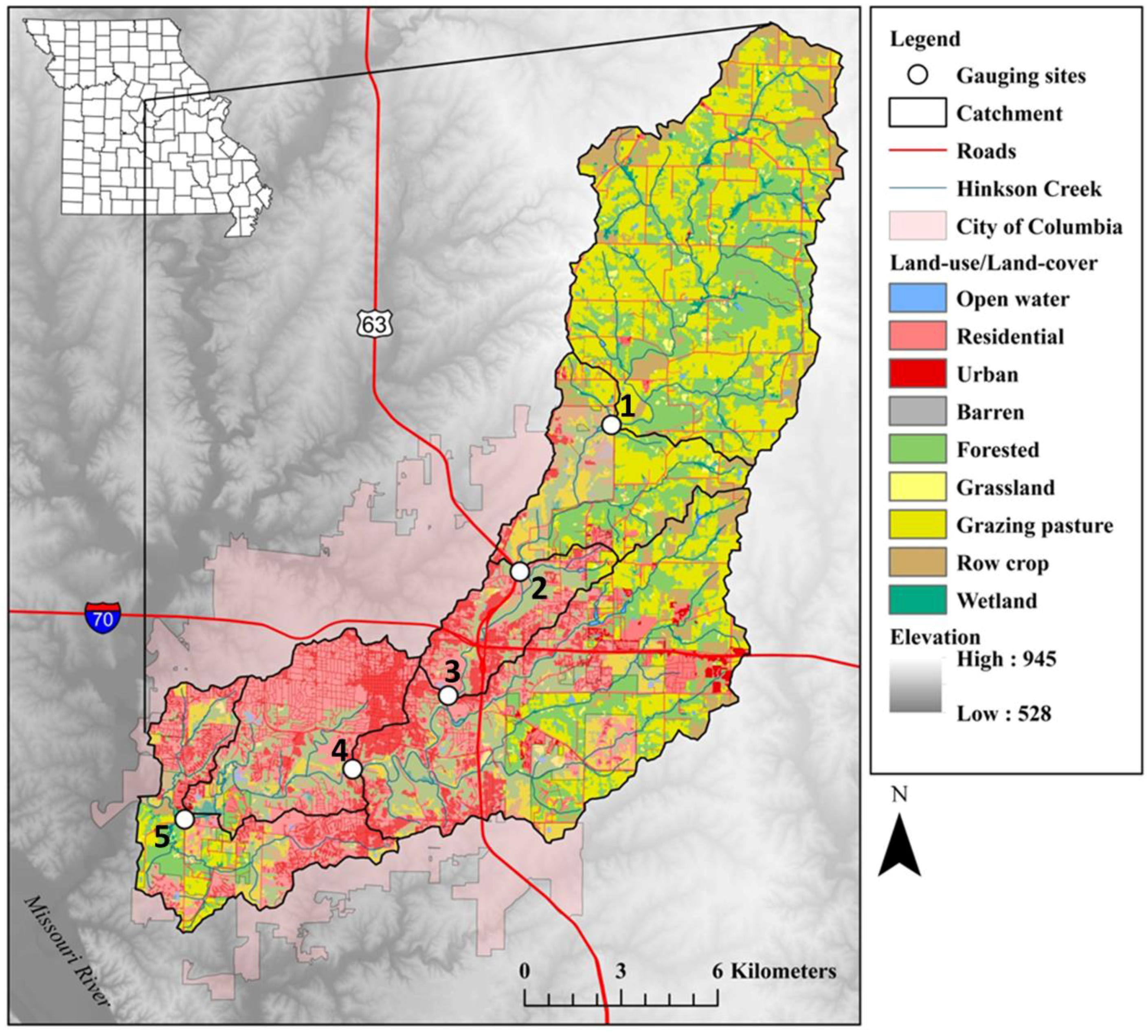
2.1. Study Site Description
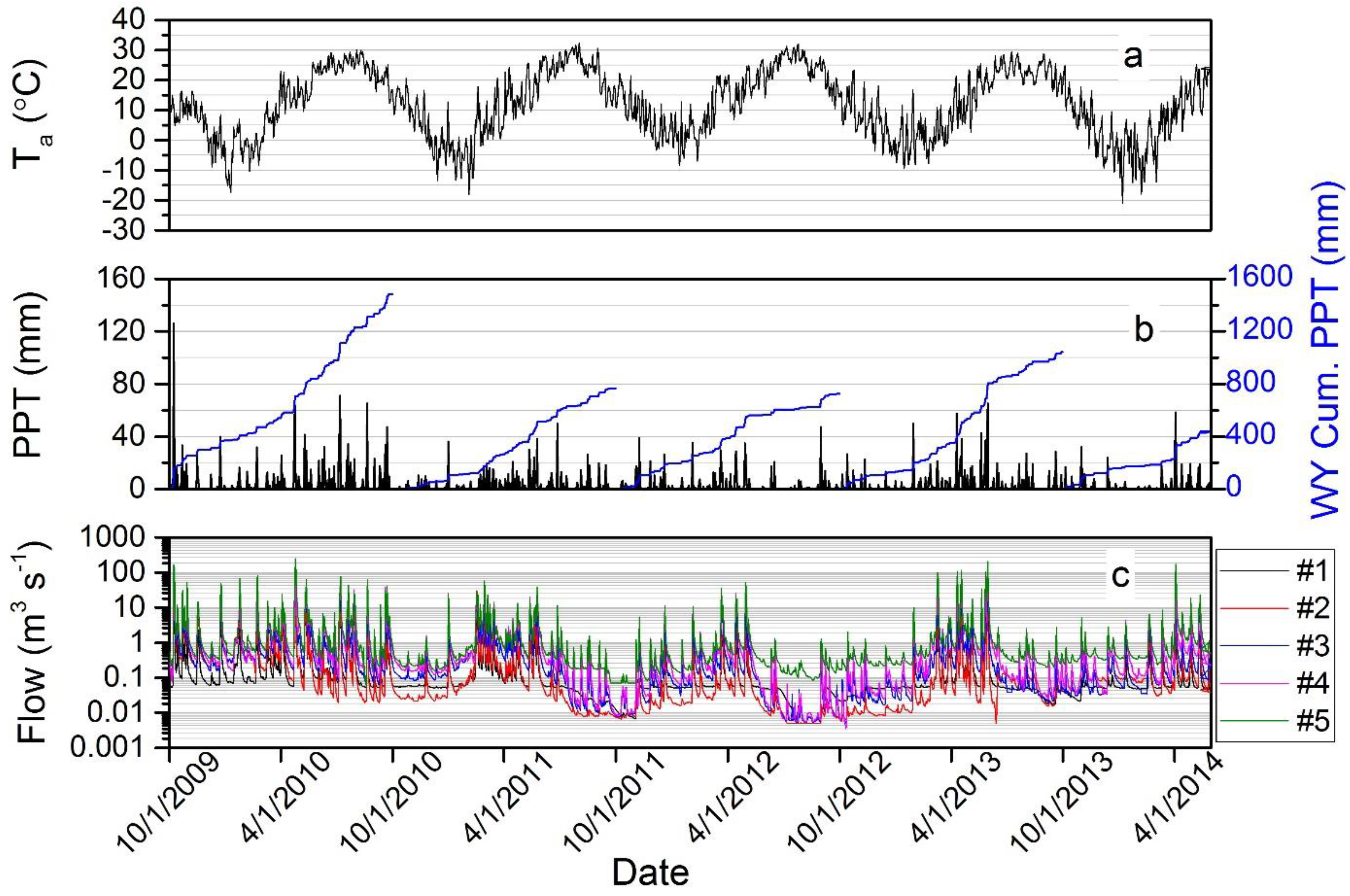
2.2. Hydroclimate Monitoring
2.3. Stream Chemistry Data Collection
2.4. Data Analyses
2.5. Hydroclimate During Study
3. Results and Discussion
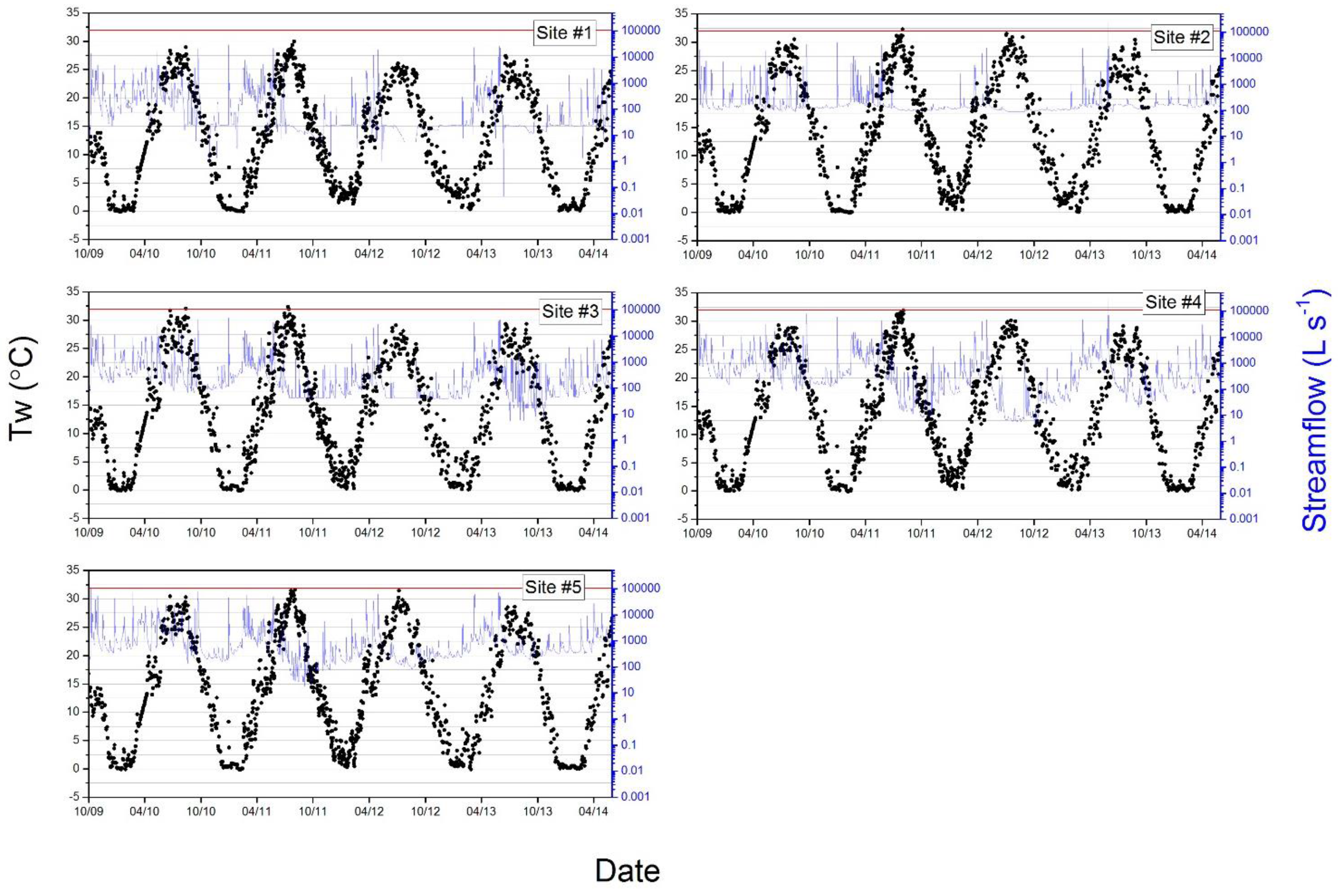
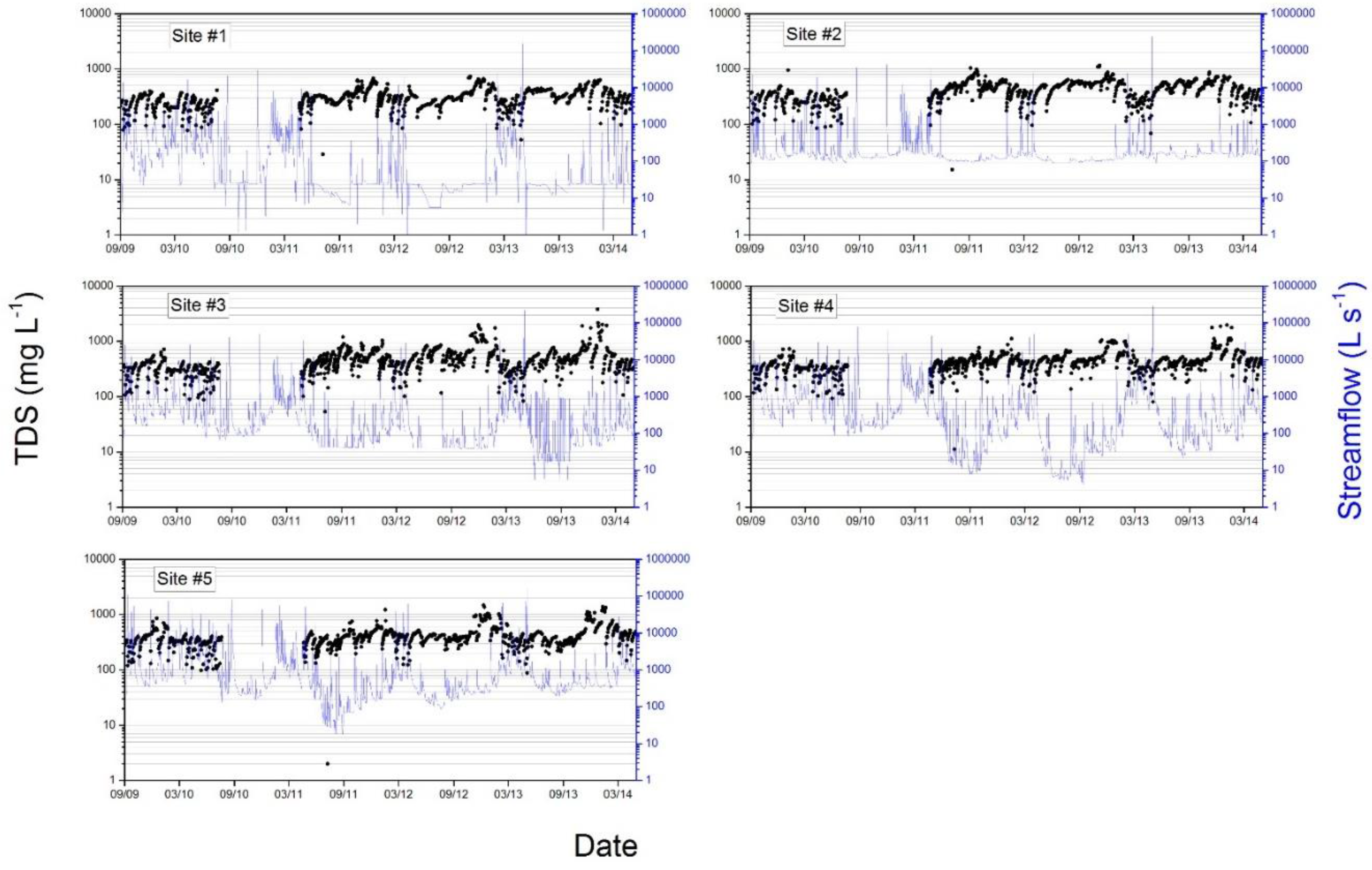
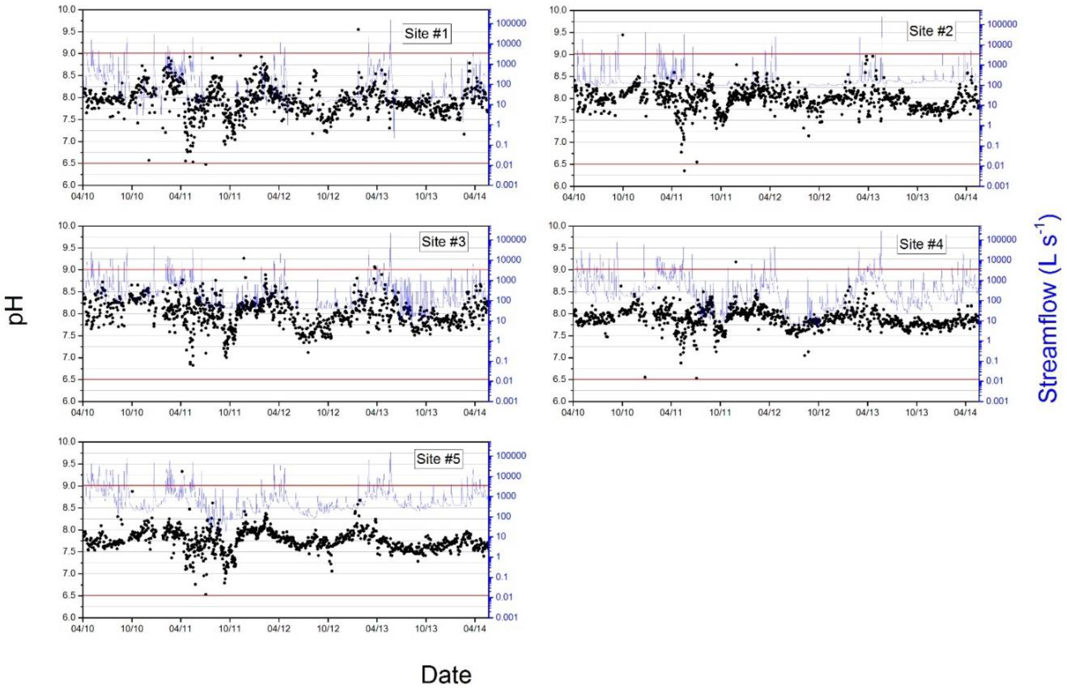
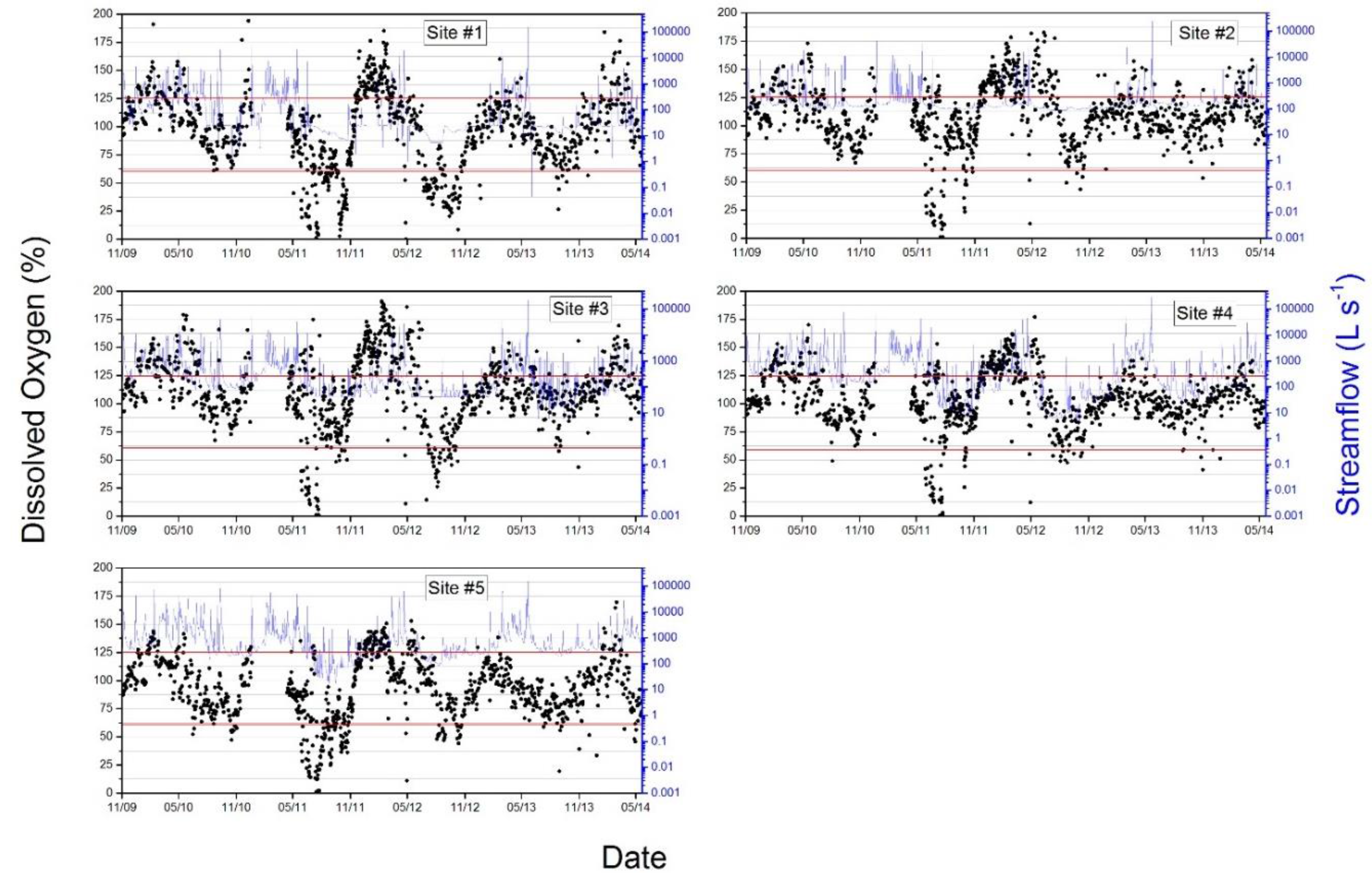
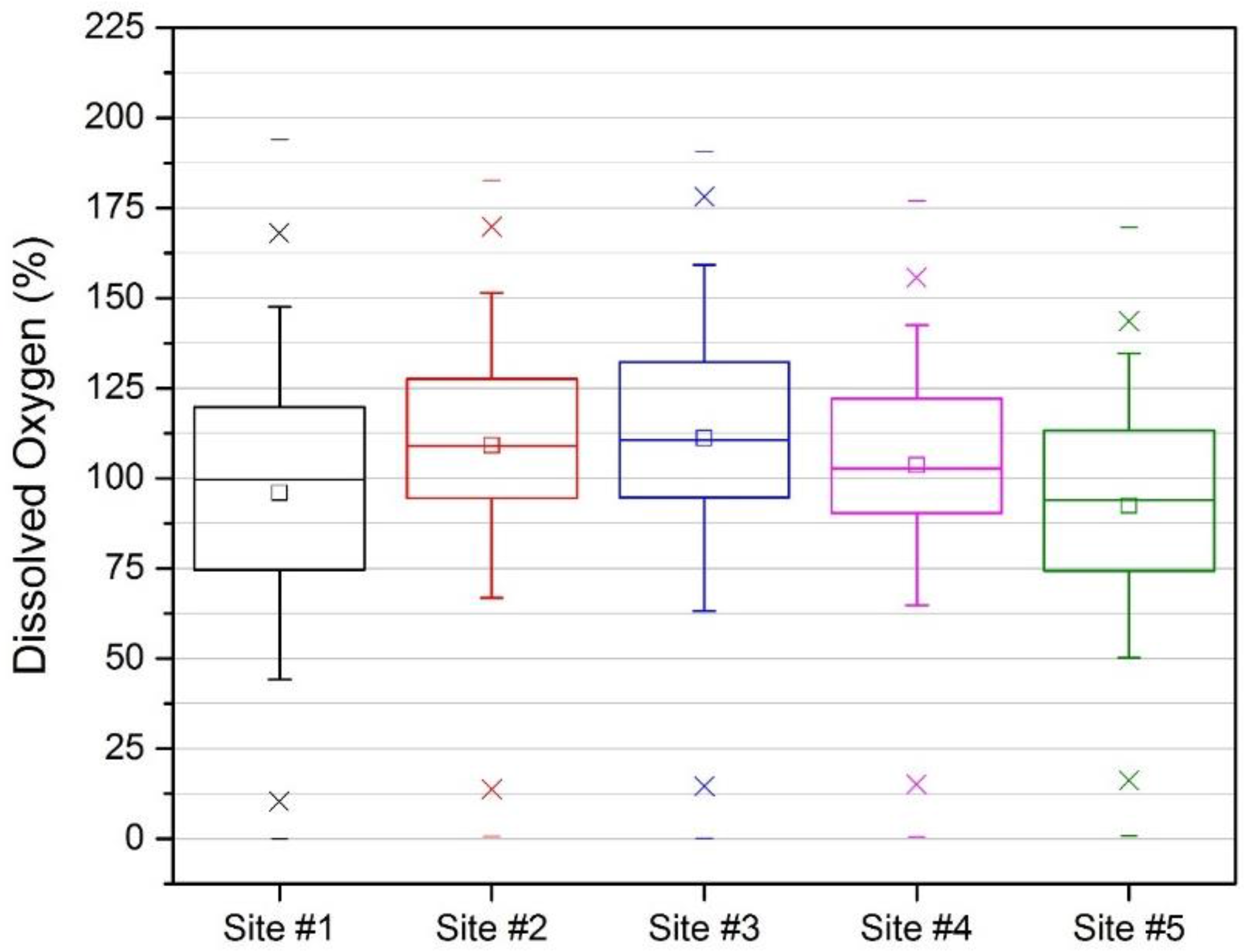
3.1. Stream Physiochemical Parameters
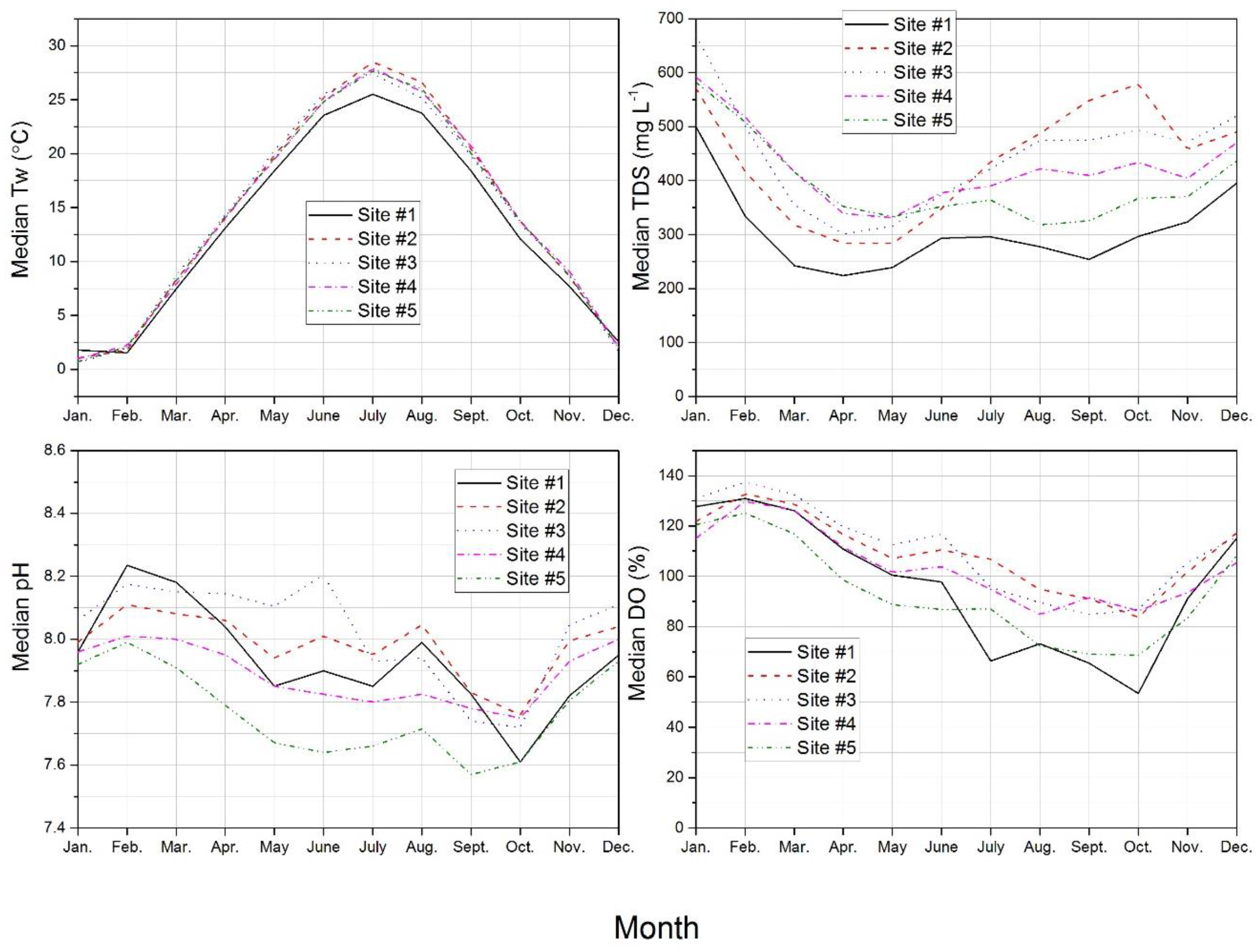
3.2. Physiochemical Parameter Seasonality and Correlation Results
3.3. Multivariate DO Modeling
3.4. Study Implications
4. Summary and Conclusions
Acknowledgments
Author Contributions
Conflicts of Interest
References
- Likens, G.E.; Bormann, F.H.; Pierce, R.S.; Eaton, J.S.; Jonhson, N.M. Biogeochemistry of a Forested Ecosystem; Springer: Millbrook, NY, USA, 1977; p. 146. [Google Scholar]
- Brezonik, P.L.; Stadelmann, T.H. Analysis and predictive models of stormwater runoff volumes, loads, and pollutant concentrations from watersheds in the Twin Cities metropolitan area, MN, USA. Water. Res. 2002, 36, 1743–1757. [Google Scholar] [CrossRef]
- Hubbart, J.A.; Kellner, E.; Hooper, L.; Lupo, A.R.; Market, P.S.; Guinan, P.E.; Stephan, K.; Fox, N.I.; Svoma, B.M. Localized climate and surface energy flux alterations across an urban gradient in the central US. Energies 2014, 7, 1770–1791. [Google Scholar] [CrossRef]
- Zeiger, S.; Hubbart, J.A.; Anderson, S.H.; Stambaugh, M.C. Quantifying and modelling urban stream temperature: A central US watershed study. Hydrol. Process. 2016, 30, 503–514. [Google Scholar] [CrossRef]
- Yates, M.V.; Gerba, C.P.; Kelley, L.M. Virus persistence in groundwater. Appl. EnvironMicrob. 1985, 49, 778–781. [Google Scholar]
- Poff, N.L.; Bledsoe, B.P.; Cuhaciyan, C.O. Hydrologic variation with land use across the contiguous United States: Geomorphic and ecological consequences for stream ecosystems. Geomorphology 2006, 79, 264–285. [Google Scholar] [CrossRef]
- Kellner, E.; Hubbart, J.A. Continuous and event-based time series analysis of observed floodplain groundwater flow under contrasting land-use types. Sci. Total. Environ. 2016, 566, 436–445. [Google Scholar] [CrossRef] [PubMed]
- Zell, C.; Kellner, E.; Hubbart, J.A. Forested and agricultural land use impacts on subsurface floodplain storage capacity using coupled vadose zone-saturated zone modeling. Environ. Earth. Sci. 2015, 74, 7215–7228. [Google Scholar] [CrossRef]
- Hubbart, J.A.; Freeman, G. Sediment laser diffraction: A new approach to an old problem in the central US. Stormwater. J. 2010, 11, 36–44. [Google Scholar]
- Ometo, J.P.H.; Martinelli, L.A.; Ballester, M.V.; Gessner, A.; Krusche, A.V.; Victoria, R.L.; Williams, M. Effects of land use on water chemistry and macroinvertebrates in two streams of the Piracicaba river basin, south-east Brazil. Freshw. Biol. 2000, 44, 327–337. [Google Scholar] [CrossRef]
- Lenat, D.R.; Crawford, J.K. Effects of land use on water quality and aquatic biota of three North Carolina Piedmont streams. Hydrobiologia 1994, 294, 185–199. [Google Scholar] [CrossRef]
- Rhodes, A.L.; Newton, R.M.; Pufall, A. Influences of land use on water quality of a diverse New England watershed. Environ. Sci. Technol. 2001, 35, 3640–3645. [Google Scholar] [CrossRef] [PubMed]
- Li, S.; Gu, S.; Liu, W.; Han, H.; Zhang, Q. Water quality in relation to land use and land cover in the upper Han River Basin, China. Catena 2008, 75, 216–222. [Google Scholar] [CrossRef]
- Bolstad, P.V.; Swank, W.T. Cumulative impacts of landuse on water quality in a southern Appalachian watershed. J. Am. Water. Resour. As. 1997, 33, 519–533. [Google Scholar] [CrossRef]
- Ross, S.W.; Dalton, D.A.; Kramer, S.; Christensen, B.L. Physiological (antioxidant) responses of estuarine fishes to variability in dissolved oxygen. Comp. Biochem. Phys. C. 2001, 130, 289–303. [Google Scholar] [CrossRef]
- Connolly, N.M.; Crossland, M.R.; Pearson, R.G. Effect of low dissolved oxygen on survival, emergence, and drift of tropical stream macroinvertebrates. J. N. Am. Benthol. Soc. 2004, 23, 251–270. [Google Scholar] [CrossRef]
- Sánchez, E.; Colmenarejo, M.F.; Vicente, J.; Rubio, A.; García, M.G.; Travieso, L.; Borja, R. Use of the water quality index and dissolved oxygen deficit as simple indicators of watersheds pollution. Ecol. Indic. 2007, 7, 315–328. [Google Scholar] [CrossRef]
- Rutledge, C.J.; Beitinger, T.L. The effects of dissolved oxygen and aquatic surface respiration on the critical thermal maxima of three intermittent-stream fishes. Environ. Biol. Fish. 1989, 24, 137–143. [Google Scholar] [CrossRef]
- O‘Connor, D.J. The temporal and spatial distribution of dissolved oxygen in streams. Water. Resour. Res. 1967, 3, 65–79. [Google Scholar] [CrossRef]
- Wilcock, R.J.; McBride, G.B.; Nagels, J.W.; Northcott, G.L. Water quality in a polluted lowland stream with chronically depressed dissolved oxygen: Causes and effects. N. Zeal. J. Mar. Freshw. 1995, 29, 277–288. [Google Scholar] [CrossRef]
- Mulholland, P.J.; Houser, J.N.; Maloney, K.O. Stream diurnal dissolved oxygen profiles as indicators of in-stream metabolism and disturbance effects: Fort Benning as a case study. Ecol. Indic. 2005, 5, 243–252. [Google Scholar] [CrossRef]
- Hubbart, J.A.; Holmes, J.; Bowman, G. TMDLs: Improving stakeholder acceptance with science-based allocations. Watershed Sci. Bull. 2010, 1, 19–24. [Google Scholar]
- Nichols, J.; Hubbart, J.A.; Poulton, B.C. Using macroinvertebrate assemblages and multiple stressors to infer urban stream system condition: A case study in the central US. Urban Ecosyst. 2016, 19, 679–704. [Google Scholar] [CrossRef]
- Zeiger, S.; Hubbart, J.A. Quantifying suspended sediment flux in a mixed-land-use urbanizing watershed using a nested-scale study design. Sci. Total. Environ. 2016, 542, 315–323. [Google Scholar] [CrossRef] [PubMed]
- Hubbart, J.A. Urban floodplain management: Understanding consumptive water use potential in urban forested floodplains. Stormwater J. 2011, 12, 56–57. [Google Scholar]
- Tsegaye, T.; Sheppard, D.; Islam, K.R.; Tadesse, W.; Atalay, A.; Marzen, L. Development of chemical index as a measure of in-stream water quality in response to land-use and land cover changes. Water Air Soil. Pollut. 2006, 174, 161–179. [Google Scholar]
- Hubbart, J.A.; Muzika, R.M.; Huang, D.; Robinson, A. Bottomland Hardwood forest influence on soil water consumption in an urban floodplain: Potential to improve flood storage capacity and reduce stormwater runoff. Watershed. Sci. Bul. 2011, 34–43. [Google Scholar]
- Hubbart, J.A.; Zell, C. Considering streamflow trend analyses uncertainty in urbanizing watersheds: A baseflow case study in the central United States. Earth Interact. 2013, 17, 1–28. [Google Scholar] [CrossRef]
- Zhou, B.; He, H.S.; Nigh, T.A.; Schulz, J.H. Mapping and analyzing change of impervious surface for two decades using multi-temporal Landsat imagery in Missouri. Int. J. Appl. Earth. Obs. 2012, 18, 195–206. [Google Scholar] [CrossRef]
- United States Census Bureau (USCB). (2015). Available online: http://quickfacts.census.gov/qfd/states/29/2915670.html (accessed on 20 August 2015).
- Missouri Climate Center. (2014). Available online: http://climate.missouri.edu/ (accessed on 17 Augest 2014).
- Kellner, E.; Hubbart, J.A. A comparison of the spatial distribution of vadose zone water in forested and agricultural floodplains a century after harvest. Sci. Total. Environ. 2016, 542, 153–161. [Google Scholar] [CrossRef] [PubMed]
- Zeiger, S.J.; Hubbart, J.A. Urban stormwater temperature surges: A central US watershed study. Hydrology 2015, 2, 193–209. [Google Scholar] [CrossRef]
- Miller, D.E.; Vandike, J.E. Groundwater Resources of Missouri, Missouri State Water Plan Series; Missouri Department of Natural Resources, Division of Geology and Land Survey: Rolla, MO, USA, 1997.
- Hooper, L.W. A Stream Physical Habitat Assessment in an Urbanizing Watershed of the Central USA. Master’s Thesis, University of Missouri-Columbia, Colombia, 2015. [Google Scholar]
- Homer, C.G.; Dewitz, J.A.; Yang, L.; Jin, S.; Danielson, P.; Xian, G.; Coulston, J.; Herold, N.D.; Wickham, J.D.; Megown, K. Completion of the 2011 National Land Cover Database for the conterminous United States-Representing a decade of land cover change information. Photogramm. Eng. Remote. Sens. 2015, 81, 345–354. [Google Scholar]
- Dottori, F.; Martina, M.L.V.; Todini, E. A dynamic rating curve approach to indirect discharge measurement. Hydrol. Earth. Syst. Sci. 2009, 13, 847. [Google Scholar] [CrossRef]
- McCuen, R.H. Modeling hydrologic change: Statistical methods; Lewis/CRC Press: Boca Raton, FL, USA, 2003. [Google Scholar]
- Helsel, D.R.; Hirsch, R.M. Statistical methods in water resources; Elsevier Science Publishers B.V.: Amsterdam, The Netherlands, 1992. [Google Scholar]
- Hauke, J.; Kossowski, T. Comparison of values of Pearson's and Spearman's correlation coefficients on the same sets of data. Quaest. Geog. 2011, 30, 87–93. [Google Scholar] [CrossRef]
- Geladi, P.; Kowalski, B.R. Partial least-squares regression: A tutorial. Anal. Chim. Acta 1986, 185, 1–17. [Google Scholar] [CrossRef]
- Tahmasebi, F.; Mahdavi, A. A two-staged simulation model calibration approach to virtual sensors for building performance data. In Proceedings of the 13th Conference of International Building Performance Simulation Association, Chambéry, France, 25–28 August 2013; pp. 25–28. [Google Scholar]
- Hubbart, J.A.; Kellner, E.; Hooper, L.W.; Zeiger, S. Quantifying loading, toxic concentrations, and systemic persistence of chloride in a contemporary mixed-land-use watershed using an experimental watershed approach. Sci. Total. Environ. 2017. [Google Scholar] [CrossRef] [PubMed]
- Svoboda, M.; LeComte, D.; Hayes, M.; Heim, R.; Gleason, K.; Angel, J.; Miskus, D. The drought monitor. Bull. Am. Meteorol. Soc. 2002, 83, 1181–1190. [Google Scholar]
- Kutta, E.; Hubbart, J. Improving understanding of microclimate heterogeneity within a contemporary plant growth facility to advance climate control and plant productivity. J. Plant Sci. 2014, 2, 167–178. [Google Scholar] [CrossRef]
- Kellner, E.; Hubbart, J.A. Application of the experimental watershed approach to advance urban watershed precipitation/discharge understanding. Urban. Ecosyst. 2016, 1–12. [Google Scholar] [CrossRef]
- Water Quality. Rules of Department of Natural Resources. Division 20: Clean Water Commission; Missouri Department of Natural Resources (MDNR): Jefferson, M.O. USA, 2014; Chapter 7; p. 102.
- Water Chemistry. Volunteer Water Quality Monitoring; Missouri Department of Natural Resources (MDNR): Jefferson, MO, USA, 2013; Chapter 2; p. 35.
- Wang, H.; Hondzo, M.; Xu, C.; Poole, V.; Spacie, A. Dissolved oxygen dynamics of streams draining an urbanized and an agricultural catchment. Ecol. Model. 2003, 160, 145–161. [Google Scholar] [CrossRef]
- Zeiger, S.J.; Hubbart, J.A. Nested-Scale Nutrient Flux in a Mixed-Land-Use Urbanizing Watershed. Hydrol. Process. 2016, 30, 1475–1490. [Google Scholar] [CrossRef]
- Carritt, D.E.; Kanwisher, J.W. Electrode system for measuring dissolved oxygen. Anal. Chem. 1959, 31, 5–9. [Google Scholar] [CrossRef]
- Caissie, D. The thermal regime of rivers: A review. Freshw. Biol. 2006, 51, 1389–1406. [Google Scholar] [CrossRef]
- Deyton, E.B.; Schwartz, J.S.; Robinson, R.B.; Neff, K.J.; Moore, S.E.; Kulp, M.A. Characterizing episodic stream acidity during stormflows in the Great Smoky Mountains National Park. Water Air Soil. Pollut. 2009, 196, 3–18. [Google Scholar]
- Tadesse, I.; Green, F.B.; Puhakka, J.A. Seasonal and diurnal variations of temperature, pH and dissolved oxygen in advanced integrated wastewater pond system® treating tannery effluent. Water. Res. 2004, 38, 645–654. [Google Scholar] [CrossRef] [PubMed]
- Serafy, J.E.; Harrell, R.M. Behavioural response of fishes to increasing pH and dissolved oxygen: Field and laboratory observations. Freshw. Biol. 1993, 30, 53–61. [Google Scholar] [CrossRef]
- Hawkins, C.P.; Sedell, J.R. Longitudinal and seasonal changes in functional organization of macroinvertebrate communities in four Oregon streams. Ecology 1981, 62, 387–397. [Google Scholar] [CrossRef]
- Madsen, J.D.; Adams, M.S. The seasonal biomass and productivity of the submerged macrophytes in a polluted Wisconsin stream. Freshw. Biol. 1988, 20, 41–50. [Google Scholar] [CrossRef]
- Rosemond, A.D. Multiple factors limit seasonal variation in periphyton in a forest stream. J. N. Am. Benthol. Soc. 1994, 13, 333–344. [Google Scholar] [CrossRef]
- Roberts, B.J.; Mulholland, P.J.; Hill, W.R. Multiple scales of temporal variability in ecosystem metabolism rates: Results from 2 years of continuous monitoring in a forested headwater stream. Ecosystems 2007, 10, 588–606. [Google Scholar] [CrossRef]
- Griffiths, N.A.; Tank, J.L.; Royer, T.V.; Roley, S.S.; Rosi-Marshall, E.J.; Whiles, M.R.; Johnson, L.T. Agricultural land use alters the seasonality and magnitude of stream metabolism. Limnol. Oceanogr. 2013, 58, 1513–1529. [Google Scholar] [CrossRef]


| Sub-Watershed# | Urban | Residential | Forest | Agriculture | Drainage Area |
|---|---|---|---|---|---|
| 1 | 0.1 | 4.5 | 36.0 | 55.9 | 79.0 |
| 2 | 3.6 | 7.6 | 37.8 | 46.7 | 23.9 |
| 3 | 26.4 | 36.8 | 27.3 | 9.0 | 13.3 |
| 4 | 12.2 | 21.3 | 32.9 | 30.9 | 65.8 |
| 5 | 18.6 | 50.8 | 23.0 | 4.2 | 25.5 |
| Parameter | Time Series | n |
|---|---|---|
| Tw | 10/1/2009–5/31/2014 | 1135 |
| TDS | 10/1/2009–8/18/2010; 5/19/2011–5/31/2014 | 949 |
| pH | 4/10/2010–9/10/2010; 9/29/2010–1/8/2011; 2/2/2011–5/31/2014 | 1004 |
| DO | 11/11/2009–12/31/2010; 4/24/2011–5/31/2014 | 1028 |
| Site #1 | Site #2 | Site #3 | Site #4 | Site #5 | |
|---|---|---|---|---|---|
| Air Temperature | |||||
| Average | 11.08 | 11.86 | 12.15 | 11.88 | 11.86 |
| Min. | –30.64 | –30.22 | –26.23 | –26.29 | –28.70 |
| Max. | 40.60 | 41.28 | 41.85 | 41.31 | 41.09 |
| Std. Dev. | 11.86 | 11.95 | 11.81 | 11.73 | 11.92 |
| Precipitation | |||||
| Total | 3824 | 4590 | 4677 | 4644 | 4568 |
| Min. | 0.0 | 0.0 | 0.0 | 0.0 | 0.0 |
| Max. | 26 | 23 | 26 | 40 | 27 |
| Std. Dev. | 0.5 | 0.5 | 0.5 | 0.5 | 0.5 |
| Streamflow | |||||
| Average | 0.57 | 0.79 | 1.34 | 2.16 | 3.21 |
| Min. | 0.01 | 0.01 | <0.01 | <0.01 | 0.04 |
| Max. | 130.64 | 163.45 | 170.41 | 323.55 | 357.70 |
| Std. Dev. | 4.54 | 5.88 | 6.66 | 11.38 | 15.54 |
| Site #1 | Site #2 | Site #3 | Site #4 | Site #5 | |
|---|---|---|---|---|---|
| Tw | |||||
| Avg. | 12.5 | 13.7 | 13.6 | 13.6 | 13.5 |
| Med. | 12.1 | 13.5 | 13.4 | 13.2 | 13.2 |
| Max. | 29.9 | 32.3 | 32.3 | 31.9 | 31.6 |
| Min. | –0.1 | –0.1 | –0.1 | –0.1 | –0.1 |
| Std. Dev. | 8.7 | 9.5 | 9.4 | 9.3 | 9.4 |
| TDS | |||||
| Avg. | 309.1 | 430.0 | 484.2 | 440.2 | 411.6 |
| Med. | 298.3 | 429.0 | 429.0 | 422.5 | 383.5 |
| Max. | 728.0 | 1144.0 | 3750.5 | 1950.0 | 1482.0 |
| Min. | 28.6 | 15.0 | 53.3 | 11.1 | 2.0 |
| Std. Dev. | 116.5 | 165.8 | 285.3 | 194.0 | 184.9 |
| pH | |||||
| Avg. | 7.9 | 8.0 | 8.0 | 7.9 | 7.8 |
| Med. | 7.9 | 8.0 | 8.1 | 7.9 | 7.8 |
| Max. | 9.6 | 9.4 | 9.3 | 9.2 | 9.3 |
| Min. | 6.5 | 6.4 | 6.8 | 6.5 | 6.5 |
| Std. Dev. | 0.4 | 0.3 | 0.3 | 0.2 | 0.3 |
| DO | |||||
| Avg. | 96.0 | 109.1 | 111.1 | 103.6 | 92.4 |
| Med. | 99.6 | 109.0 | 110.6 | 102.7 | 93.9 |
| Max. | 194.0 | 182.6 | 190.8 | 177.0 | 169.6 |
| Min. | 1.2 | 0.7 | 0.1 | 0.6 | 0.8 |
| Std. Dev. | 34.3 | 28.2 | 32.0 | 25.9 | 28.1 |
| Site # | Tw | TDS | pH | DO |
|---|---|---|---|---|
| 1 | –0.29 * | –0.09 * | 0.24 * | 0.54 * |
| 2 | –0.24 * | –0.51 * | 0.02 | 0.27 * |
| 3 | –0.12 * | –0.45 * | –0.05 | 0.30 * |
| 4 | –0.23 * | –0.41 * | 0.25 * | 0.31 * |
| 5 | –0.15 * | –0.17 * | 0.01 | 0.19 * |
| Site # | y-Int. | Tw | pH | TDS | Flow | R2 | NRMSE (%) |
|---|---|---|---|---|---|---|---|
| 1 | –28.36 | –0.44 | 5.48 | 3.87 | n/a | 0.72 | 28 |
| 2 | –23.97 | –0.37 | 5.22 | –1.31 | 3.66 × 10⁻⁶ | 0.70 | 21 |
| 3 | –27.35 | –0.41 | 5.66 | –0.32 | 6.47 × 10⁻⁶ | 0.74 | 22 |
| 4 | –17.46 | –0.34 | 4.24 | n/a | –2.82 × 10⁻⁶ | 0.71 | 21 |
| 5 | –30.53 | –0.31 | 5.66 | 2.62 × 10⁻³ | 1.21 × 10⁻⁵ | 0.74 | 24 |
© 2017 by the authors. Licensee MDPI, Basel, Switzerland. This article is an open access article distributed under the terms and conditions of the Creative Commons Attribution (CC BY) license (http://creativecommons.org/licenses/by/4.0/).
Share and Cite
Kellner, E.; Hubbart, J.A. Advancing Understanding of the Surface Water Quality Regime of Contemporary Mixed-Land-Use Watersheds: An Application of the Experimental Watershed Method. Hydrology 2017, 4, 31. https://doi.org/10.3390/hydrology4020031
Kellner E, Hubbart JA. Advancing Understanding of the Surface Water Quality Regime of Contemporary Mixed-Land-Use Watersheds: An Application of the Experimental Watershed Method. Hydrology. 2017; 4(2):31. https://doi.org/10.3390/hydrology4020031
Chicago/Turabian StyleKellner, Elliott, and Jason A. Hubbart. 2017. "Advancing Understanding of the Surface Water Quality Regime of Contemporary Mixed-Land-Use Watersheds: An Application of the Experimental Watershed Method" Hydrology 4, no. 2: 31. https://doi.org/10.3390/hydrology4020031
APA StyleKellner, E., & Hubbart, J. A. (2017). Advancing Understanding of the Surface Water Quality Regime of Contemporary Mixed-Land-Use Watersheds: An Application of the Experimental Watershed Method. Hydrology, 4(2), 31. https://doi.org/10.3390/hydrology4020031