
Teaching Innovation in STEM Education Using an Unmanned Aerial Vehicle (UAV)


Abstract
:1. Introduction
1.1. Benefits of Using UAVs in Education
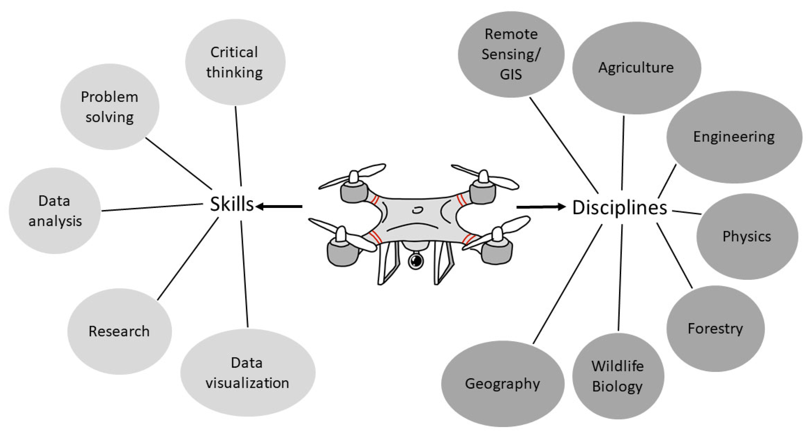
1.2. Applications of UAVs in Various Fields
2. Materials and Methods
2.1. Background of the Course
2.2. Experimental Design
3. Results
4. Discussion
5. Conclusions
Supplementary Materials
Author Contributions
Funding
Institutional Review Board Statement
Informed Consent Statement
Data Availability Statement
Conflicts of Interest
References
- Federal Aviation Authority. Unmanned Aircraft Systems. Available online: https://www.faa.gov/uas/2015 (accessed on 14 December 2021).
- Watts, A.C.; Ambrosia, V.G.; Hinkley, E.A. Unmanned aircraft systems in remote sensing and scientific research: Classification and considerations of use. Remote Sens. 2012, 4, 1671–1692. [Google Scholar] [CrossRef] [Green Version]
- Salami, E.; Barrado, C.; Pastor, E. UAV flight experiments applied to the remote sensing of vegetated areas. Remote Sens. 2014, 6, 11051–11081. [Google Scholar] [CrossRef] [Green Version]
- AL-Tahir, R. Integrating UAV into Geomatics Curriculum. In The International Archives of the Photogrammetry, Proceedings of the Remote Sensing and Spatial Information Sciences, Toronto, ON, Canada, 30 August–2 September 2015; Copernicus Publications: Toronto, ON, Canada, 2015. [Google Scholar]
- Joyce, K.E.; Meiklejohn, N.; Mead, P.C.H. Using minidrones to teach geospatial technology fundamentals. Drones 2020, 4, 57. [Google Scholar] [CrossRef]
- King, L.G.; McKim, A.J.; Raven, M.R.; Pauley, C.M. New and emerging technologies: Teacher needs, adoption, methods, and student engagement. J. Agric. Educ. 2019, 60, 277–290. [Google Scholar] [CrossRef]
- Alkaabi, K.; Abdelgadir, A. Applications of unmanned aerial vehicle (UAV) technology for research and education in UAE. Int. J. Soc. Sci. Hum. 2017, 5, 4–11. [Google Scholar]
- Cliffe, A.D. Evaluating the introduction of unmanned Aerial Vehicles for teaching and learning in geoscience fieldwork education. J. Geogr. High. Educ. 2019, 43, 582–598. [Google Scholar] [CrossRef]
- Finn, R.L.; Wright, D. Privacy, data protection and ethics for civil drone practice: A survey of industry, regulators and civil society organizations. Comput. Law Secur. Rev. 2016, 32, 577–586. [Google Scholar] [CrossRef]
- Everaerts, J. The use of unmanned aerial vehicles (UAVs) for remote sensing and mapping. Int. Arch. Photogramm. Remote Sens. Spat. Inf. Sci.-ISPRS Arch. 2008, 37, 1187–1191. [Google Scholar]
- Anthony, D.; Elbaum, S.; Lorenz, A.; Detweiler, C. On crop height estimation with UAVs. In Proceedings of the International Conference on Intelligent Robots and Systems, Chicago, IL, USA, 14–18 September 2014. [Google Scholar]
- Berni, J.; Zarco-Tejada, P.; Suarez, L.; Fereres, E. Thermal and narrowband multi-spectral remote sensing for vegetation monitoring from an unmanned aerial vehicle. IEEE Trans. Geosci. Remote Sens. 2009, 47, 722–738. [Google Scholar] [CrossRef] [Green Version]
- Han, X.; Thomasson, J.A.; Bagnall, G.C.; Pugh, N.A.; Horne, D.W.; Rooney, W.I.; Jung, J.; Change, A.; Malambo, L.; Popescu, S.C.; et al. Measurement and calibration of plant-height from fixed-wing UAV images. Sensors 2018, 18, 4092. [Google Scholar] [CrossRef] [Green Version]
- Zarco-Tejada, P.; González-Dugo, V.; Berni, J. Fluorescence, temperature and narrow-band indices acquired from a UAV platform for water stress detection using a micro-hyperspectral imager and a thermal camera. Remote Sens. Environ. 2012, 117, 322–337. [Google Scholar] [CrossRef]
- Rueda-Ayala, V.P.; Pena, J.M.; Hoglind, M.; Bengochea-Guevara, J.M.; Andujar, D. Comparing UAV-based technologies and RGB-D reconstruction methods for plant height and biomass monitoring on grass ley. Sensors 2019, 19, 535. [Google Scholar] [CrossRef] [Green Version]
- Krause, S.; Sanders, T.G.M.; Mund, J.; Greve, K. UAV-based photogrammetric tree height measurement for intensive forest monitoring. Remote Sens. 2019, 11, 758. [Google Scholar] [CrossRef] [Green Version]
- Corte, A.P.D.; Rex, F.E.; Alves de Almeida, D.R.; Sanquetta, C.R.; Silva, C.A.; Moura, M.M.; Wilkinson, B.; Zambrano, A.M.A.; Neto, E.M.C.; Veras, H.F.P.; et al. Measuring individual tree diameter and height using Gatoreye high-density UAV-LiDAR in an integrated crop-livestock-forest system. Remote Sens. 2020, 12, 863. [Google Scholar] [CrossRef] [Green Version]
- Jin, C.; Oh, C.; Shin, S.; Njungwi, N.W.; Choi, C. A comparative study to evaluate accuracy on canopy height and density using UAV, ALS, and fieldwork. Forests 2020, 11, 241. [Google Scholar] [CrossRef] [Green Version]
- Dunford, R.; Michel, K.; Gagnage, M.; Piegay, H.; Tremelo, M.L. Potential and constraints of unmanned aerial vehicle technology for the characterization of Mediterranean riparian forest. Int. J. Remote Sens. 2009, 30, 4915–4935. [Google Scholar] [CrossRef]
- Siewert, M.B.; Olofsson, J. Scale-dependency of Arctic ecosystem properties revealed by UAV. Environ. Res. Lett. 2020, 15, 094030. [Google Scholar] [CrossRef]
- Frakenberger, J.R.; Huang, C.; Nouwakpo, K. Low-altitude digital photogrammetry technique to assess ephemeral gully erosion. In Proceedings of the 2008 IEEE International Geoscience and Remote Sensing Symposium, Boston, MA, USA, 7–11 July 2008; pp. 117–120. [Google Scholar]
- D’Oleire-Oltmanns, S.; Marzolff, I.; Peter, K.D.; Ries, J.B. Unmanned aerial vehicle (UAV) for monitoring soil erosion in Morocco. Remote Sens. 2012, 4, 3390–3416. [Google Scholar] [CrossRef] [Green Version]
- Eltner, A.; Baumgart, P.; Maas, H.G.; Faust, D. Multi-temporal UAV data for automatic measurement of rill and interrill erosion on loess soil. Earth Surf. Proc. Land 2015, 40, 741–755. [Google Scholar] [CrossRef]
- Bernard, E.; Friedt, J.M.; Tolle, F.; Marlin, C.; Griselin, M. Using a small COTS UAV to quantify moraine dynamics inducted by climate shift in Arctic environments. Int. J. Remote Sens. 2016, 38, 2481–2494. [Google Scholar]
- Hodgson, J.C.; Baylis, S.M.; Mott, R.; Herrod, A.; Clarke, R.H. Precision wildlife monitoring using unmanned aerial vehicles. Sci. Rep. 2016, 6, 22574. [Google Scholar] [CrossRef] [PubMed] [Green Version]
- Fortuna, J.; Ferreira, F.; Gomes, R.; Ferreira, S.; Sousa, J. Using low cost open source UAVs for marine wild life monitoring. In Proceedings of the 2nd IFAC Workshop on Research, Education, and Development of Unmanned Aerial Systems, Compiegne, France, 20–22 November 2013; pp. 291–295. [Google Scholar]
- Mangewa, L.J.; Ndakidemi, P.A.; Munishi, L.K. Integrating UAV technology in an ecological monitoring system for community wildlife management areas in Tanzania. Sustainability 2019, 11, 6116. [Google Scholar] [CrossRef] [Green Version]
- Sona, G.; Pinto, L.; Pagliari, D.; Passoni, D.; Gini, R. Experimental analysis of different software packages for orientation and digital surface modeling from UAV images. Earth Sci. Inform. 2014, 7, 97–107. [Google Scholar] [CrossRef]
- Torres-Sanchez, J.; Lopez-Granados, F.; Borra-Serrano, I.; Pena, J.M. Assessing UAV-collected image overlap influence on computation time and digital surface model accuracy in olive orchards. Precision Agric. 2018, 19, 115–133. [Google Scholar] [CrossRef]
- Gebrehiwot, A.A.; Hashemi-Beni, L. Three-dimensional inundation mapping using UAV image segmentation and digital surface model. ISPRS Int. J. Geo-Inf. 2021, 10, 144. [Google Scholar] [CrossRef]
- Eriksen, C.; Ming, K.; Dodds, Z. Accessible aerial robotics. J. Comput. Sci. 2014, 29, 218–227. [Google Scholar]
- Nitschke, C.; Minami, Y.; Hiromoto, M.; Ohshima, H.; Sato, T. A quadrocopter automatic control contest as an example of interdisciplinary design education. In Proceedings of the 14th International Conference on Control, Automation and Systems (ICCAS), Seoul, Korea, 22–25 October 2014. [Google Scholar]
- He, Y.; Lu, H.; Song, Y.; Liu, L. Design and implementation of virtual simulation experiment system for acquisition and production of UAV real-scene 3D data. In Proceedings of the IEEE 4th International Conference on Automation, Electronics, and Electrical Engineering, Shenyang, China, 19–21 November 2021. [Google Scholar]
- Valderrama, R.P.; Ocana, L.B.; Sheremetov, L.B. Development of intelligent reusable learning objects for web-based education systems. Expert Syst. Appl. 2005, 28, 273–283. [Google Scholar] [CrossRef]
- ArcGIS Pro: Release 9.1; Environmental Systems Research Institute: Redlands, CA, USA, 2021.
- Metashape; Agisoft. Available online: https://www.agisoft.com/ (accessed on 16 December 2021).
- Clemson University. Undergraduate Catalog System; Clemson University: Clemson, SC, USA, 2021. [Google Scholar]
- Mesas-Carrascosa, F.J.; Porras, F.P.; Trivino-Tarradas, P.; Merono de Larriva, J.E.; Garcia-Ferrer, A. Project-based learning applied to unmanned aerial systems and remote sensing. Remote Sens. 2019, 11, 2413. [Google Scholar] [CrossRef] [Green Version]
- Gillani, B.; Gillani, R. From droughts to drones: An after-school club uses drones to learn about environmental science. Sci. Child. 2015, 53, 50–54. [Google Scholar] [CrossRef]
- He, X.; Hua, X.; Montillet, J.P.; Yu, K.; Zou, J.; Xiang, D.; Zhu, H.; Zhang, D.; Huang, Z.; Zhao, B. An innovative virtual simulation teaching platform on digital mapping with unmanned aerial vehicle for remote sensing education. Remote Sens. 2019, 11, 2993. [Google Scholar] [CrossRef] [Green Version]
- Stoker, C.; Bennett, R.; Nex, F.; Gerke, M.; Zevenbergen, J. Review of the current state of UAV regulations. Remote Sens. 2017, 9, 459–485. [Google Scholar] [CrossRef] [Green Version]
- Giurato, M.; Gattazzo, P.; Lovera, M. UAV lab: A multidisciplinary UAV design course. IFAC PapersOnLine 2019, 52, 490–495. [Google Scholar] [CrossRef]
- Williams, R.D.; Tooth, S.; Gibson, M. The sky is the limit: Reconstructing physical geography from an aerial perspective. J. Geogr. High. Educ. 2017, 41, 134–146. [Google Scholar] [CrossRef] [Green Version]
- DroneDeploy. Available online: https://www.dronedeploy.com (accessed on 12 January 2022).
- DJITerra. DJI. Available online: https://www.dji.com/dji-terra (accessed on 14 January 2022).
- Pix4Dmapper. Pix4D. Available online: https://www.pix4d.com/product/pix4dmapper-photogrammetry-software (accessed on 14 January 2022).
- WebODM. Open Drone Map. Available online: https://www.opendronemap.org/webodm/ (accessed on 12 January 2022).

| Survey Questions | Responses | |||
|---|---|---|---|---|
| What is your major? | FOR (11) | ENR (14) | WFB (21) | Other (6) |
| What is your academic classification (year)? | Sophomore (0) | Junior (2) | Senior (45) | Graduate (5) |
| How would you describe yourself? | Female (25) | Male (27) | ||
| Steps | Activity Description |
|---|---|
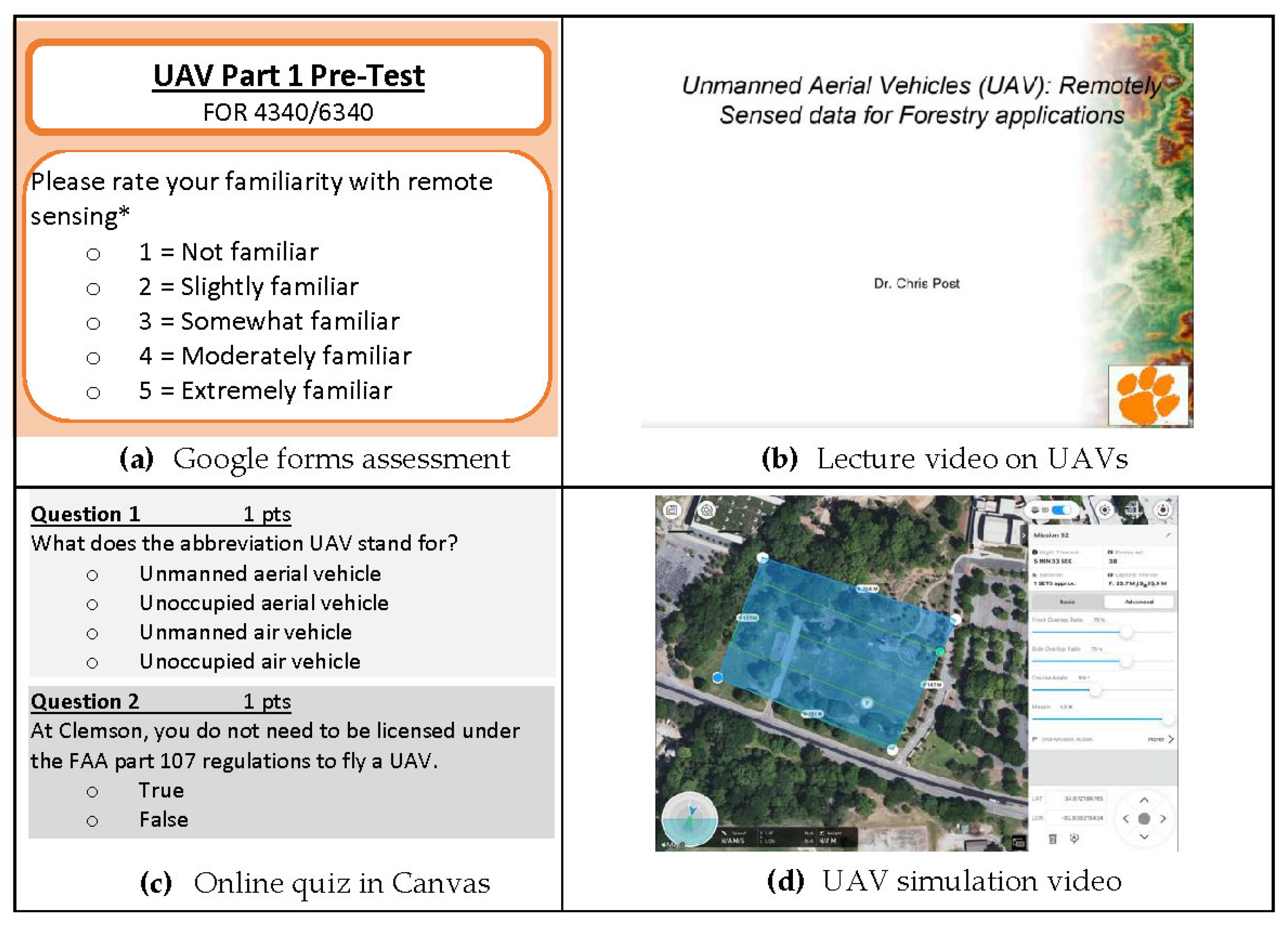
| Part 1: Pre-assessment | Students answer an online survey via Google Forms about their familiarity with remote sensing and UAVs. |
| Part 2: Lecture + UAV Simulation Videos | Students watch a video lecture on UAVs and a series of five short videos illustrating the necessary steps to fly a UAV. |
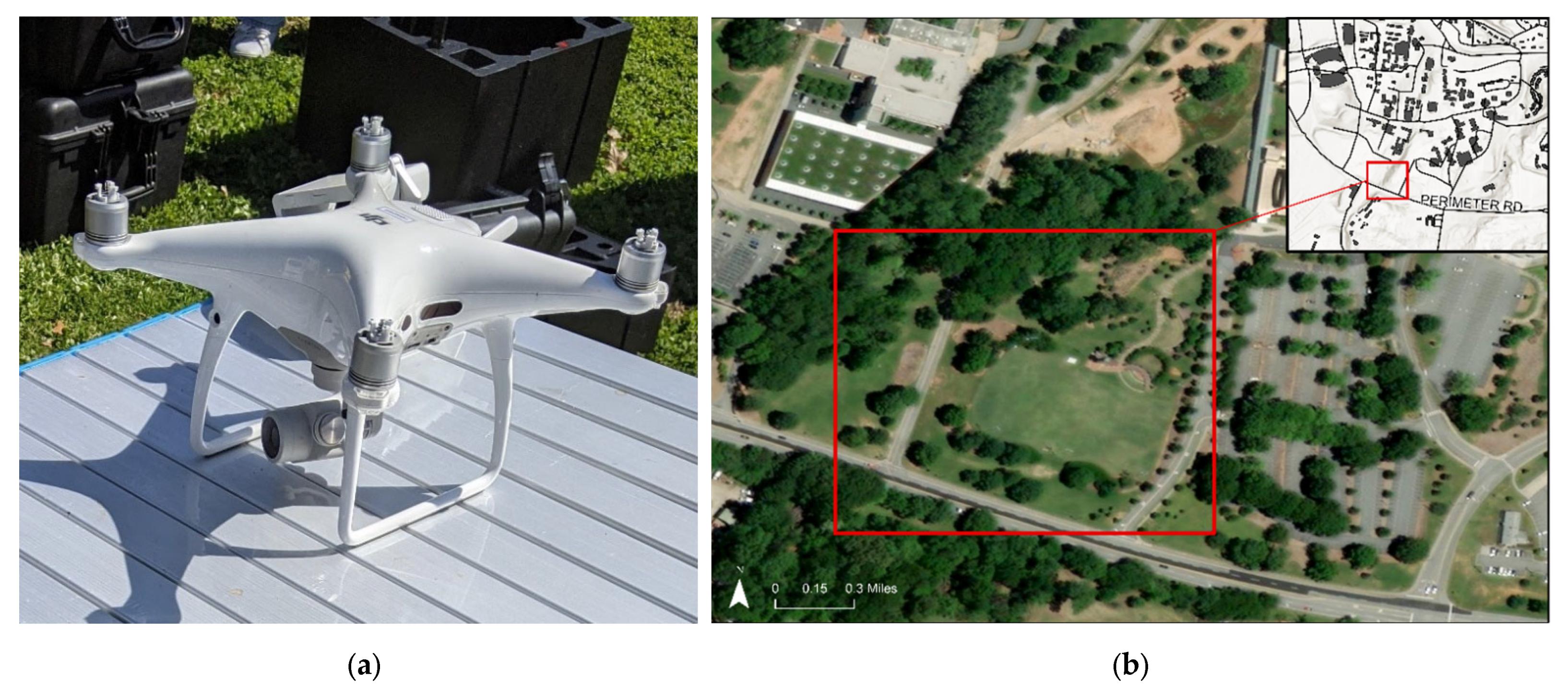
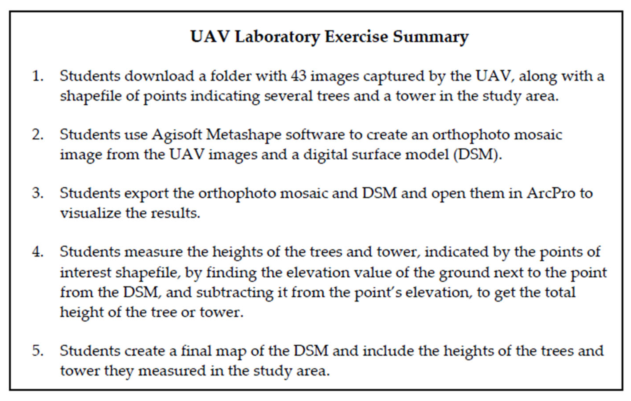
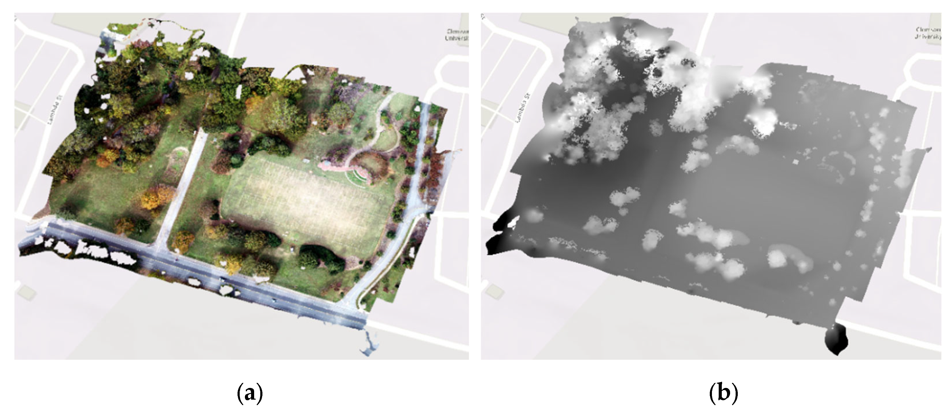
| Part 3: Laboratory Exercise | Students complete the laboratory exercise in which they download images captured by the UAV and use Agisoft Metashape to process them into an orthophoto mosaic and digital surface model. They then use the DSM to calculate the height of trees and other points of interest in the study area. |
| Part 4: Graded Online Quiz | Students take a 10-question, 10-point online graded quiz in Canvas. |
| Part 5: Post-assessment | Students answer an online follow-up survey via Google Forms on their experience with the laboratory exercise and education module. |
| Equipment | Requirements |
|---|---|
| CPU (central processing unit) | 4–8 core Intel, 2.0+ GHz |
| GPU (graphics processing unit) | NVIDIA or AMD with >700 CUDA cores |
| Operating system | Windows, macOS, or Linux |
| Internet access | Minimum 100 Mbps |
| RAM (random access memory) | 16–32 GB |
| Survey Questions and Answers | Responses (%) | ||
|---|---|---|---|
| Pre-Assessment (n = 52) | Post-Assessment (n = 51) | Difference | |
| Please, rate your familiarity with remote sensing. | |||
| 1 = Not familiar 2 = Slightly familiar 3 = Somewhat familiar 4 = Moderately familiar 5 = Extremely familiar | 19.2 38.5 30.8 11.5 0 | 0 0 27.5 60.8 11.8 | −19.2 −38.5 −3.3 +49.3 +11.8 |
| A drone is a common term for an unmanned aerial vehicle (UAV). | |||
| True False | 98.1 1.9 | 100 0 | +1.9 −1.9 |
| Please, rate your familiarity with UAVs/drones. | |||
| 1 = Not familiar 2 = Slightly familiar 3 = Somewhat familiar 4 = Moderately familiar 5 = Extremely familiar | 9.6 57.7 26.9 5.8 0 | 0 0 29.4 54.9 15.7 | −9.6 −57.7 +2.5 +49.1 +15.7 |
| Which of the following is a product that cannot be created using a UAV? | |||
| 3D point cloud Aerial orthophoto Digital surface model (DSM) Shapefile | 30.8 0 5.8 63.5 | 5.9 0 2 92.2 | −24.9 0 −3.8 +28.7 |
| A UAV is an important tool for gathering information for natural resource research. | |||
| True False | 98.1 1.9 | 100 0 | +1.9 −1.9 |
| What is the average pixel resolution for images taken by a UAV? | |||
| 1–3 mm 1–3 inches 1–3 feet 1–3 m | 15.4 26.9 34.6 23.1 | 13.7 78.4 2 5.9 | −1.7 +51.5 −32.6 −17.2 |
| Is the operation of a UAV during flight typically a manual process or an automated process? | |||
| Manual—the pilot must fly the UAV at all times with a controller | 55.8 | 11.8 | −44 |
| Automated—the pilot does not need to fly the UAV with the controller during most parts of the flight | 44.2 | 88.2 | +44 |
| What is the end result of a typical UAV flight? | |||
| 100’s of individual photos One large orthophoto A digital surface model (DSM) An orthophoto and a digital surface model (DSM) | 71.2 1.9 1.9 25 | 92.2 0 0 7.8 | +21 −1.9 −1.9 −17.2 |
| To create an orthophoto and a digital surface model (DSM), you need to: | |||
| Download these products from the UAV | 9.6 | 3.9 | −5.7 |
| Process the individual images using software that creates an orthophoto and a DSM | 80.8 | 96.1 | +15.3 |
| Download these products from the UAV’s accompanying app | 9.6 | 0 | −9.6 |
| The UAV simulation and laboratory was an effective way to learn about using UAVs for natural resource research. | |||
| 1 = Strongly disagree 2 = Disagree 3 = Neither agree nor disagree 4 = Agree 5 = Strongly agree | - - - - - | 0 0 7.8 52.9 39.2 | - - - - - |
| Pre-Test Definition by Students | Post-Test Definition by Students |
|---|---|
| Remote sensing | |
| Collecting data from a distance. | Mapping the Earth’s surface and its above-ground features using satellites, UAVs, and other applications. |
| Mapping the surface of the Earth from above. | Gathering data and physical characteristics from the reflectance of objects from a satellite. |
| Gathering information from an object without physically touching it. | Collecting information about Earth’s surface and above-ground features using radiation, including visible light, infrared, temperature, etc. |
| Using aircrafts to collect images of the ground. | The use of technology to collect data about an area without physically being there. |
| Using a drone, satellite, or another device that can take readings from far away to measure something about the area. | Using sensors such as thermal, multi-spectral, and imaging sensors to collect data from a distance, such as using UAV or other flying technologies/satellites. |
| Quiz Questions, and Answers | Respondents | Responses (%) |
|---|---|---|
| What does the abbreviation UAV stand for? | ||
| Unmanned aerial vehicle Unoccupied air vehicle Unmanned air vehicle Unoccupied aerial vehicle | 49 0 2 0 | 96 0 4 0 |
| At Clemson, you do not need to be licensed under the FAA Part 107 regulations to fly a UAV. | ||
| True False | 4 47 | 8 92 |
| What is the height limit for flying a UAV above the ground? | ||
| 100 feet 250 feet 400 feet 750 feet | 1 0 50 0 | 2 0 98 0 |
| A digital surface model (DSM) contains height information of trees. | ||
| True False | 45 6 | 88 12 |
| Hyperspectral sensors on UAVs can help identify areas of drought stress. | ||
| True False | 49 2 | 96 4 |
| Which of the following is not a type of sensor used to collect information with UAVs? | ||
| LiDAR Multispectral Pressure Red, Green, Blue Thermal | 1 0 46 4 0 | 2 0 90 8 0 |
| What is a digital surface model? | ||
| Earth’s surface and its above-ground features Bare earth elevation Height of trees and buildings above ground level | 46 1 4 | 90 2 8 |
| UAVs can be flown in all weather conditions. | ||
| True False | 1 50 | 2 98 |
| What is the first step when flying a UAV? | ||
| Plan the flight on the iPad Launch the drone Conduct a pre-flight inspection | 8 0 43 | 16 0 84 |
| Which of the following has a higher spatial resolution? | ||
| NAIP aerial photo UAV photo 30 m DEM Landsat 9 satellite images | 1 45 2 3 | 2 88 4 6 |
| Responses |
|---|
| T1. Enjoyment of Learning |
| I enjoyed seeing how my knowledge changed before and after learning about UAVs through the Google Forms questions. |
| Creating the DSM and Orthophoto was enjoyable, especially since we don’t use software outside of ArcGIS Pro too often. |
| I liked learning how to effectively use UAVs, and I hope to use this information in the field in the near future. |
| I enjoyed this lab and thought it was well structured. |
| I really enjoyed the way this lab was set up and feel like I have a really good grasp of the material. |
| This was one of my favorite labs. |
| I really enjoyed looking at the details of the orthophoto image we created. |
| T2. Value of Multimedia |
| The visual demonstration helped portray what it is like to use a UAV. At first, I thought you had to manually fly them. |
| The videos were a helpful tool to understand the background of the UAV as well as looking at the DSM and orthophotos. |
| The visuals definitely helped me understand how this could be useful for many areas of research. |
| I enjoyed using pictures of a familiar area. For some reason, this made me more interested in what I was doing and allowed me to visualize and understand what I was doing on a deeper level. |
| I enjoyed watching the videos of the UAV flying process over the Tiger Band Plaza. |
| I thought it was done well, and the combination of the videos and the lab helped me understand the concepts well. |
| I liked being able to see the stark difference in resolutions from the UAV and the satellite images. I understand the importance and the value of them! |
| T3. Flexibility of Learning |
| I found it easy to go through the steps and learned a lot more than I knew beforehand about drones and remote sensing. |
| The exercise was a good way to see how people use drones to get data about the surrounding environment. |
| It was helpful seeing the data collected and then using the same data in lab. |
| Seeing the final product after creating the DSM was very satisfying. |
| It was neat to see how all the individual images came together to create the orthophoto. |
| Seeing how the images were collected was helpful—the videos were short but contained the necessary information, which I appreciated. |
| T4. Applicability of Content |
| I was happy that the instructions were very useful in completing this lab exercise. |
| I liked getting experience using Agisoft Metashape. |
| I think the exercise was very well organized and helped me to actually understand what I was doing. |
| I thought that this lab did a good job at providing a basic understanding of how UAVs are used and how to create orthophotos and DSMs from them. |
| I enjoyed how structured it was. I never felt lost. |
| I understood everything that was presented. It’s a well-organized lesson. |
| T5. Criticism |
| Would have been cool to see a UAV in action, but this was a good at home intro. |
| It would have been more effective if we could learn how to use the drones in person. |
| Physical demonstration of UAV on lab talking about its parts and what we do before flight at least if possible (not UAV flight) on lab rather than video. |
| I think it would be easier if it was text to read instead of watching videos. |
| Having an in-person lab where the UAV could be demonstrated would be helpful. |
| The ArcGIS component could be more intensive/thorough than calculating tree heights. |
| I would have liked to see a bit more instructions after combining all of the images to do more with them. |
| You could bring the drone into class for a quick walkthrough of the flight plan and precheck, so we know how to use drone software. |
| The amount of separate parts for this assignment made me think that it was going to take me forever, so maybe combine some of the steps so there aren’t as many parts. |
| Questions | Answer to Question | |
|---|---|---|
| 1. Does your subject matter integrate with teaching UAV applications? | Yes | No |
Consider what a UAV can measure:
| Think of alternative ways to use UAVs to study your topic. Examples of appropriate exercises: calculate the area of a specific object of interest, measure the height of objects, and visualize an area from above. | |
| 2. Do you have access to a UAV? | Yes | No |
| If you have access, consider the UAV flying and institution insurance regulations/requirements that may necessitate the pilot to be certified. Would a certification requirement limit your access to using the UAV? | Conduct in-person and hands-on learning opportunities. | Utilize online teaching material, simulations, and exercises. |
| 3. How familiar are the students with UAVs? | Basic | Advanced |
| Consider the age of the students, as well as their technology literacy, when designing the UAV teaching material. | Focus on introductory teaching material on UAVs and simple exercises/demonstrations. | Explore more advanced UAV topics like sensor options. Have students conduct complex projects with UAV data. |
| 4. Are you designing an entire course based on UAVs? | Yes | No |
| How much time do you have to dedicate to UAVs? This will determine the mode of instruction. | Incorporate a semester-long project for students to apply the skills and knowledge. | Teach a 1-day workshop or a laboratory exercise. |
| 5. Where will you fly the UAV to collect data? | Public land | Private land |
| Consider location restrictions for UAV flights. Many countries restrict flight near airports and other protected areas like parks and military zones. Consider UAV flying regulations. In some countries, flying in the dark and flying over people are prohibited. | Acquire appropriate permission to fly from the owner. | |
| 6. Do you have access to UAV post-processing software? | Yes | No |
| Consider the software and hardware needs for processing the UAV imagery after collection. | Free or free-trial software options include DJI Terra, Drone Deploy, DroneMapper RAPID, Pix4DMapper, WedODM. | |
Publisher’s Note: MDPI stays neutral with regard to jurisdictional claims in published maps and institutional affiliations. |
© 2022 by the authors. Licensee MDPI, Basel, Switzerland. This article is an open access article distributed under the terms and conditions of the Creative Commons Attribution (CC BY) license (https://creativecommons.org/licenses/by/4.0/).
Share and Cite
Bolick, M.M.; Mikhailova, E.A.; Post, C.J. Teaching Innovation in STEM Education Using an Unmanned Aerial Vehicle (UAV). Educ. Sci. 2022, 12, 224. https://doi.org/10.3390/educsci12030224
Bolick MM, Mikhailova EA, Post CJ. Teaching Innovation in STEM Education Using an Unmanned Aerial Vehicle (UAV). Education Sciences. 2022; 12(3):224. https://doi.org/10.3390/educsci12030224
Chicago/Turabian StyleBolick, Madeleine M., Elena A. Mikhailova, and Christopher J. Post. 2022. "Teaching Innovation in STEM Education Using an Unmanned Aerial Vehicle (UAV)" Education Sciences 12, no. 3: 224. https://doi.org/10.3390/educsci12030224
APA StyleBolick, M. M., Mikhailova, E. A., & Post, C. J. (2022). Teaching Innovation in STEM Education Using an Unmanned Aerial Vehicle (UAV). Education Sciences, 12(3), 224. https://doi.org/10.3390/educsci12030224