1. Introduction
Herbert Louis [
1] proposed the concept of the “urban fringe area” (
stadtrand zonen) in 1936. An urban fringe is located between an urban built-up and a rural area. The urban fringe area is transitional, gradual, and dynamic in numerous aspects, such as population, economy, land use, and ecology [
2,
3,
4]. Depicted as a typical ecotone, an urban fringe plays an important role in urban evolution. China has previously undergone a dramatic urbanization process. The urbanization level was 49.9% in 2010 and reached 57.35% by 2016 [
5]. The studies on the evolution of the urban fringe are significant in strengthening the orderly management of land resources and realizing the rational control of urban development and rural urbanization [
6].
The primary task of an urban fringe region study is to execute the spatial recognition and boundary division of the urban fringe area. No uniform standard is available for the extraction of an urban fringe [
6]. The urban fringe depicts significant differences between two continuous areas. Population diversity, and economic and social development factors are the most obvious characteristics of urban fringes in China [
4,
7]. Therefore, some scholars have adopted economic and social indicators to divide the urban fringe area. Researchers used fuzzy comprehensive evaluation method or a logistic regression model to define the urban fringe area, but these statistical data are updated slowly. In addition, the administrative boundary is also used as the statistical unit, which is not consistent with the reality of urban fringes [
7,
8,
9,
10,
11].
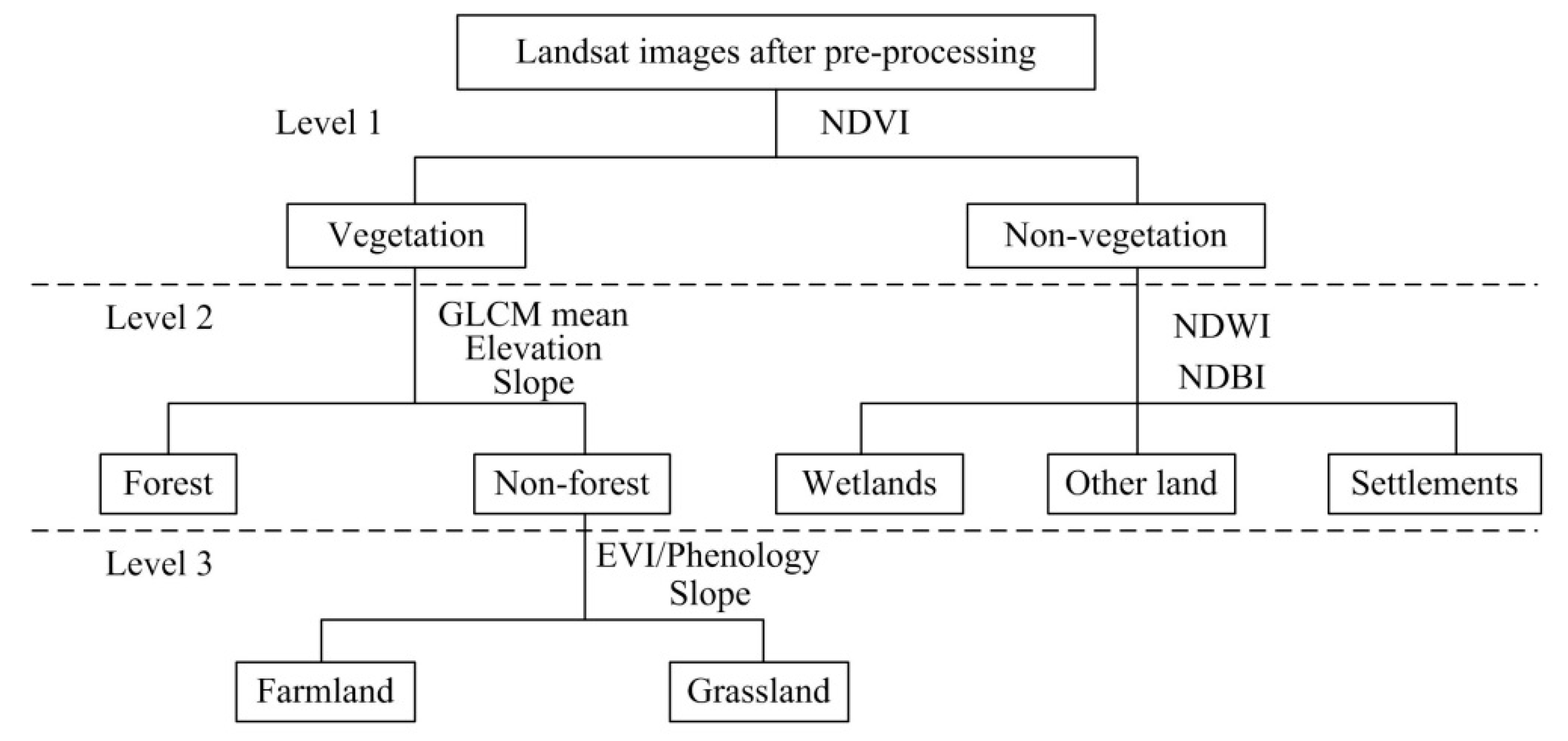
The land use structure in an urban fringe is complex relative to the core area of a city. Therefore, an assessment based on the land use structure is feasible [
12]. Remote sensing provides high-frequency earth observation data over a broad spatiotemporal scale in a spatially explicit manner [
6]. Several scholars have conducted research on the urban fringe recognition method by using remote sensing data [
13,
14,
15,
16]. Different indexes, such as urban land use ratio, land use dynamic degree, and land use comprehensive index, are extracted and detected by mutation, and the urban fringe area is extracted. However, the selected indexes do not reflect the complexity of the land use structure in the urban fringe. Some studies apply the information entropy principle to determine the urban fringe through the threshold, but the selected threshold is subjective. The “breakpoint” analysis method proposed by Converse [
17] in 1949 is mainly applied to determine the scope of the urban fringe. The basic principle is to select the maximum distance of the distance attenuation mutation of each element as the end of the flow and change. Therefore, this study combines the “breakpoint” method and the information entropy index in the extraction of urban fringe areas. The urban marginal area differs from the relatively stable natural geographic interface that often shows dynamic characteristics [
18,
19]. Thus, exploring the dynamic changes of urban fringe areas by using long-time series land use data is necessary.
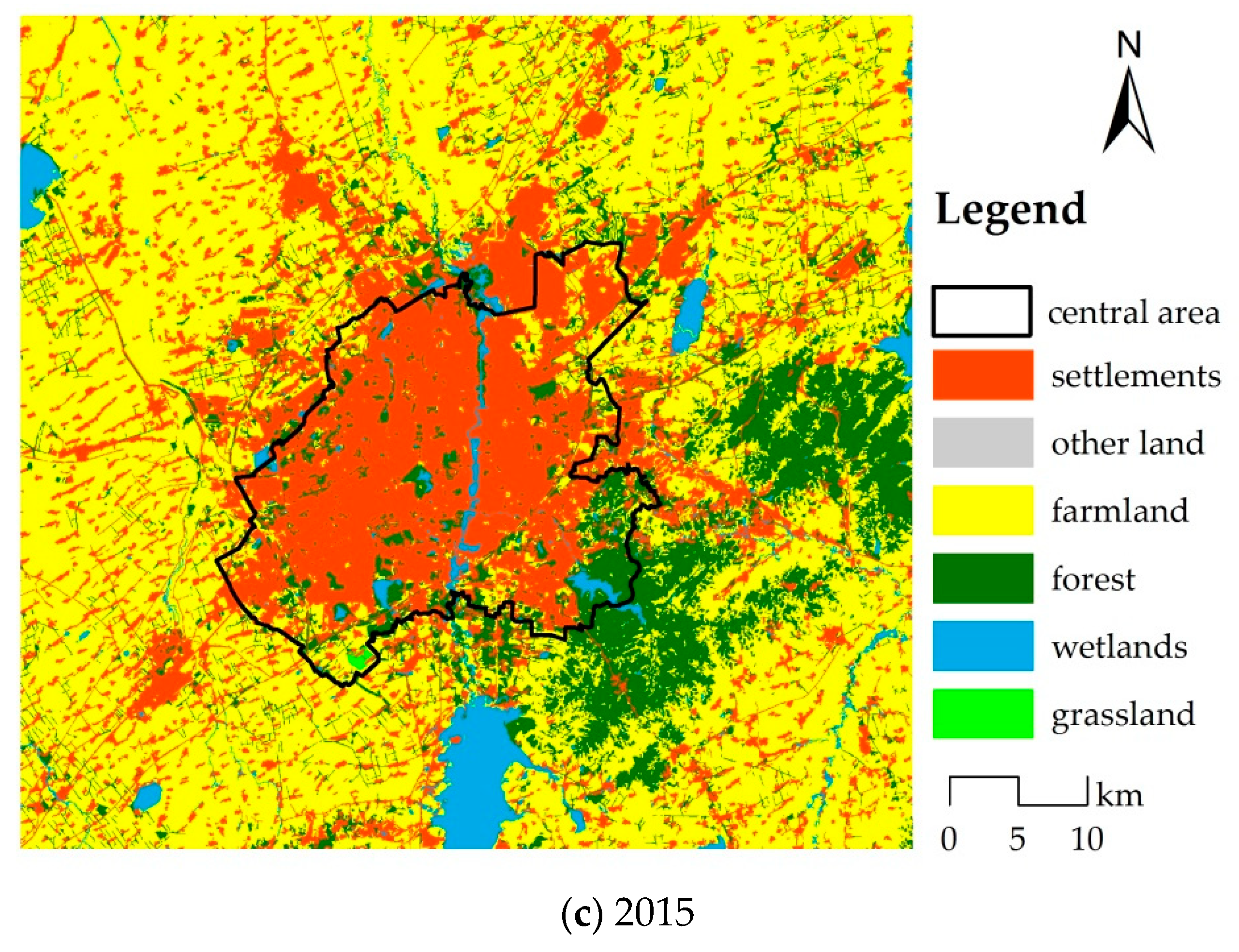
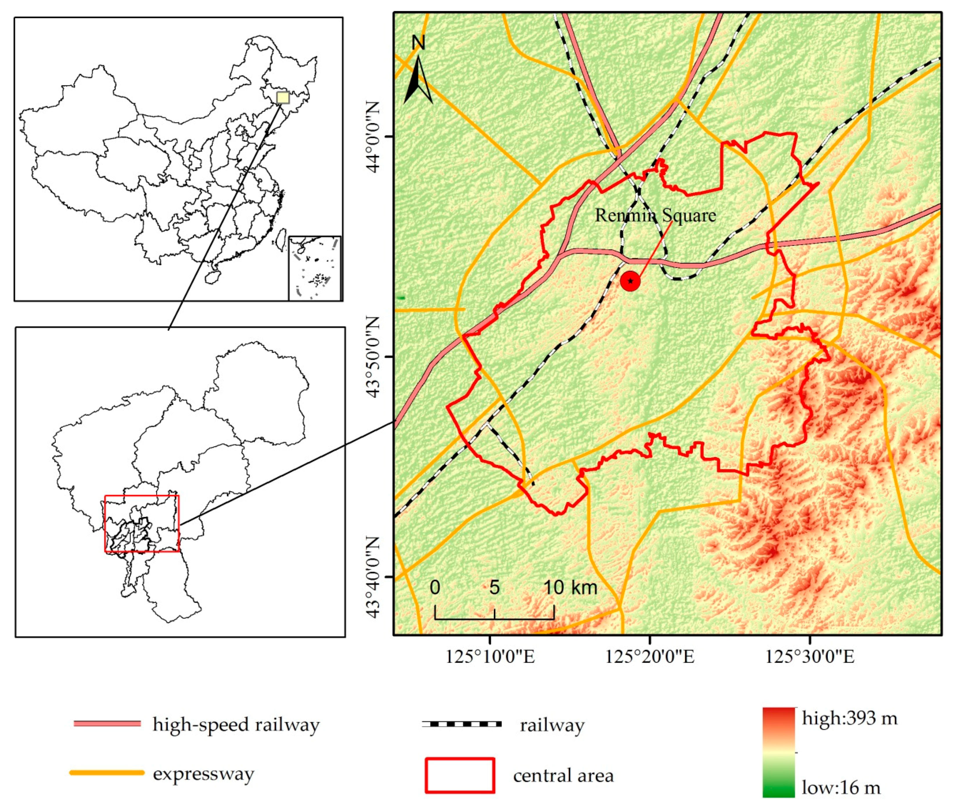
Changchun is located in the hinterland of the Songliao Plain in northeastern China, facing the dual problems of economic development and environmental protection. The years since 1995 have seen population growth and economic development, with the strategy of revitalizing the old industry base in Northeast China. From 2010 to 2015, Changchun’s central area measured 610 km
2, which is only 0.25% of the total area of Jilin Province, but the total population increased from 3.13 million to 3.48 million, and the proportion of the total population in the province increased from 11.40% to 12.64%. With the rapid development of urbanization, urban population and land gradually extended to the urban fringe [
20]. The ecological environment in the urban fringe of Changchun is also facing threats. In 2009, the State Council formally approved the regional cooperation and development program involving the development of Tumen River and Changchun–Jilin–Tumen to signal the rise in construction in the area. In 2016, the State Council further approved the establishment of Changchun New Area, covering 499 km
2, which has a rich water system, high forest coverage, and strong ecological sensitivity. Therefore, the study of the changes in the fringe area of Changchun is also significant for future spatial planning. In China, the 1994 tax reform stabilized the central government’s revenue, but the revenue share of the local governments was not commensurate with the increased local responsibility. As land is a scarce resource in urban China compared with the abundant labor supply, selling land through rapid urban spatial expansion can meet the financial demands of local governments. For this reason, the land economy has become a main driving force in China’s urbanization [
1]. Thus, understanding the spatial–temporal patterns can provide valuable insights for planners and decision makers to plan and renovate the urban fringe.
Numerous studies have been conducted on the identification of urban fringes, but only a few studies have focused on their temporal and spatial characteristics [
21,
22]. This study uses Changchun, a rapidly growing city, as an example of evaluating the change dynamic characteristics of the urban fringe, in which land use data were acquired from remote sensing images. This study hopes to provide a methodical reference for urban fringe dynamic assessment and a highly accurate and scientific reference for urban planning.
4. Results and Discussion
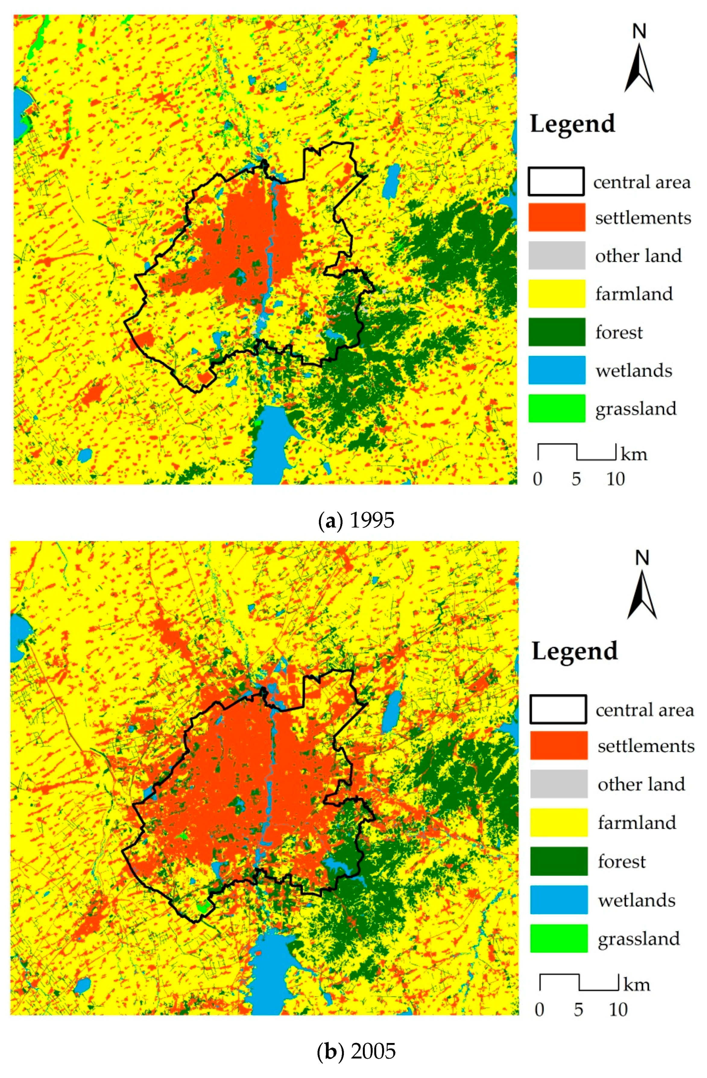
4.1. Land Use Transition in Central Area
From the perspective of spatial distribution, settlements and farmland are the main land use types in the central area, followed by forest. From 1995 to 2005, the change of land use in Changchun was dramatic. The city extended to the E, SE, and southwest (SW). Furthermore, the surrounding farmland was converted into settlements (
Figure 4). The area of settlements in the central area increased from 213.73 km
2 to 379.70 km
2, which increased by 77.65%, and the average growth was 16.60 km
2 per year. Along the road, a large area of farmland converted to settlements was also observed. The increase of forest area was mainly due to the conversion of other land use types in the SW part. During 2005–2015, the city continued to spread to the northeast (NE), SE, and SW, the speed of urban expansion slowed down, the area of settlements increased to 412.84 km
2, the annual increase was 3.31 km
2, and the main type of change was farmland conversion to settlements.
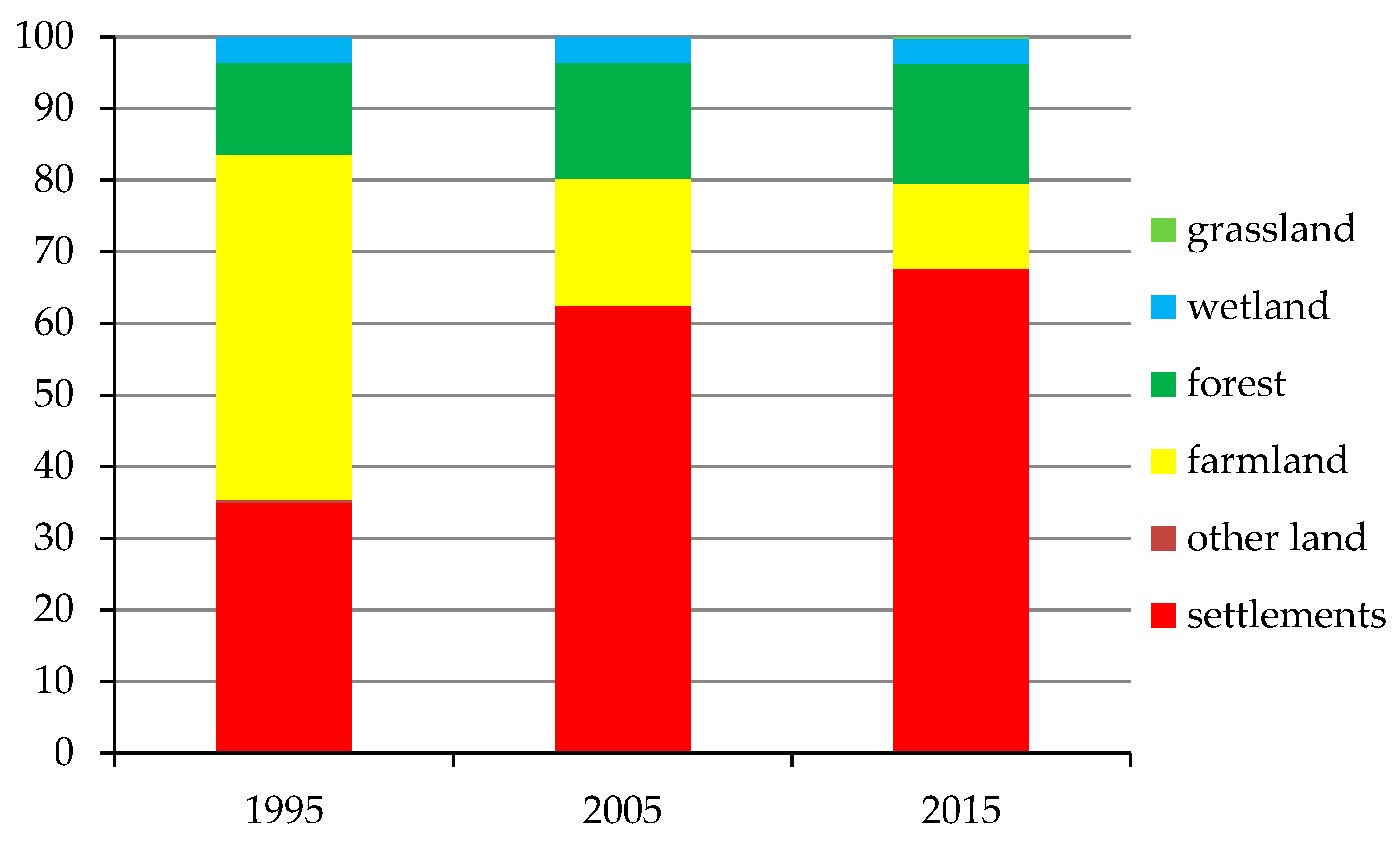
The land use structure changed significantly during 1995–2005, and the proportion of settlements increased from 35.04% to 62.50%, whereas the proportion of farmland areas declined from 48.05% to 17.76%. The proportion of forest increased from 12.97% to 16.17%. From 2005 to 2015, the proportion of different land use types changed slowly. The main change was that the proportion of land use continued to grow to 67.69%, and the proportion of farmland decreased to 11.83% (
Figure 5).
4.2. Quantitative Change Characteristics
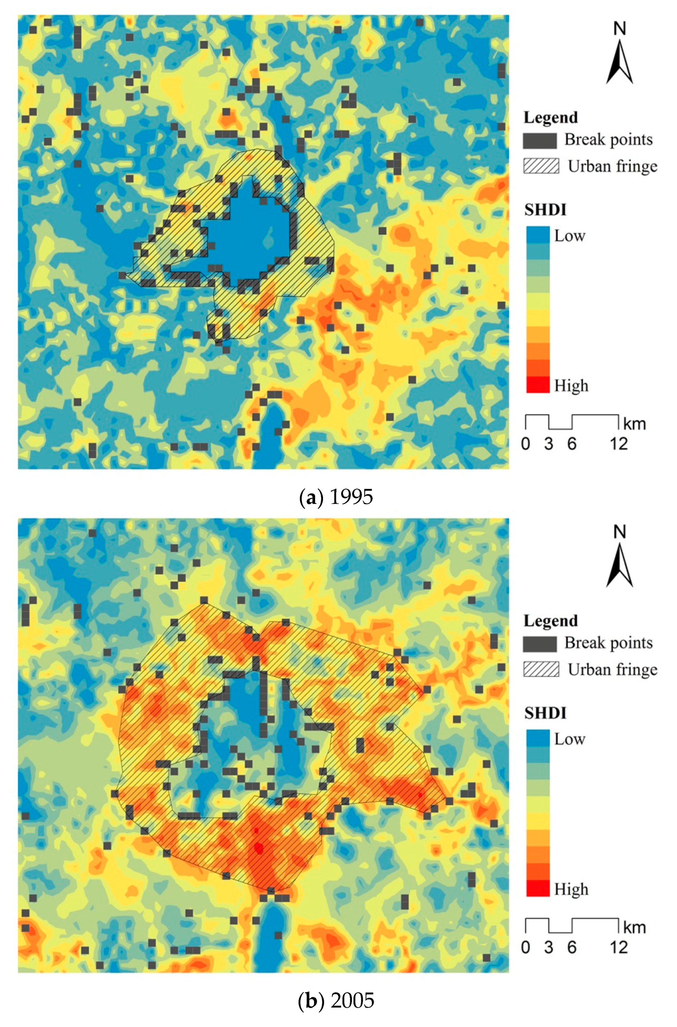
In 1995, 2005, and 2015, the urban fringe areas of Changchun were 269.72, 773.03, and 802.85 km
2, respectively (
Figure 6). The urban core areas of Changchun were 108.84, 262.97, and 367.12 km
2, respectively. From 1995 to 2015, the core area of Changchun increased by 258.28 km
2 at the rate of 237.30%. The urban fringe area increased by 533.13 km
2 at the growth rate of 197.66%. The growth rate of the urban core area was lower than that of the urban fringe area, and the degree of expansion of the urban fringe was higher than that of the core area (
Table 4).
During the first period (1995–2005), the urban core area increased by 154.13 km2, whereas the urban fringe increased by 503.31 km2 (i.e., 3.27 times the growth of the core area). From 2005 to 2015, both growth rates of the urban core and the urban fringe decreased, by which the growth rate of the urban fringe was lower than that of the urban core.
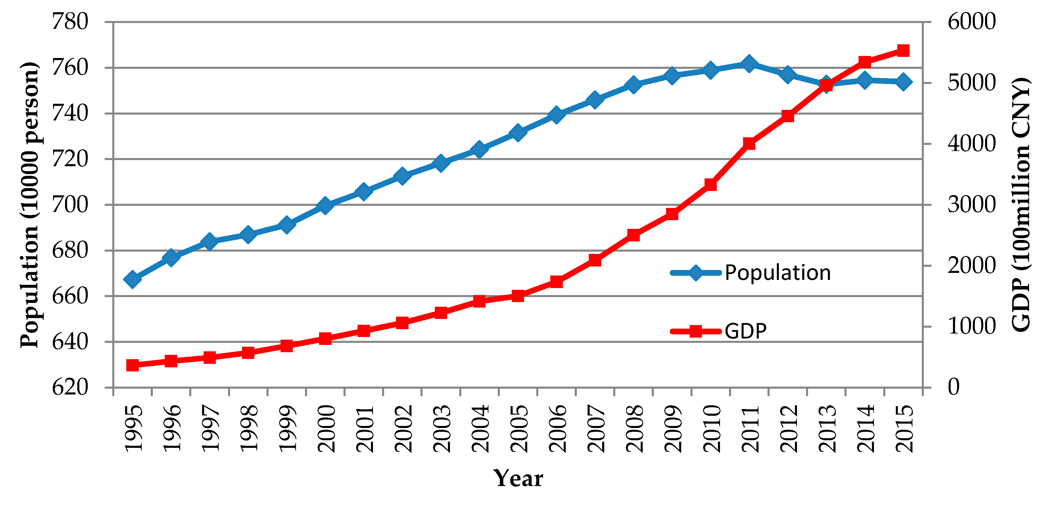
Economic development and population growth, which are the basic driving forces of urban expansion, are also major factors affecting the land use change in the urban fringe area. During 1995–2005, the growth of urban fringe was closely related to the speed of urban expansion. The average annual growth rate of gross domestic product (GDP) in Changchun was 31.13%, with an annual population increase of 64.2 thousand persons (
Figure 7). The development of urban economy needs the support of space. The increase of population will strengthen the urban residents’ demand for housing, transportation, and public facilities and then expand the urban land to the outside, thereby significantly changing the land structure around the city and increasing the border area. In total, in the second stage, that is, during 2005–2015, GDP and population growth slowed, especially after 2010 when the population of Changchun declined, the demand for urban space declined, and the growth rate of urban fringe areas decreased accordingly.
4.3. Expansion Direction
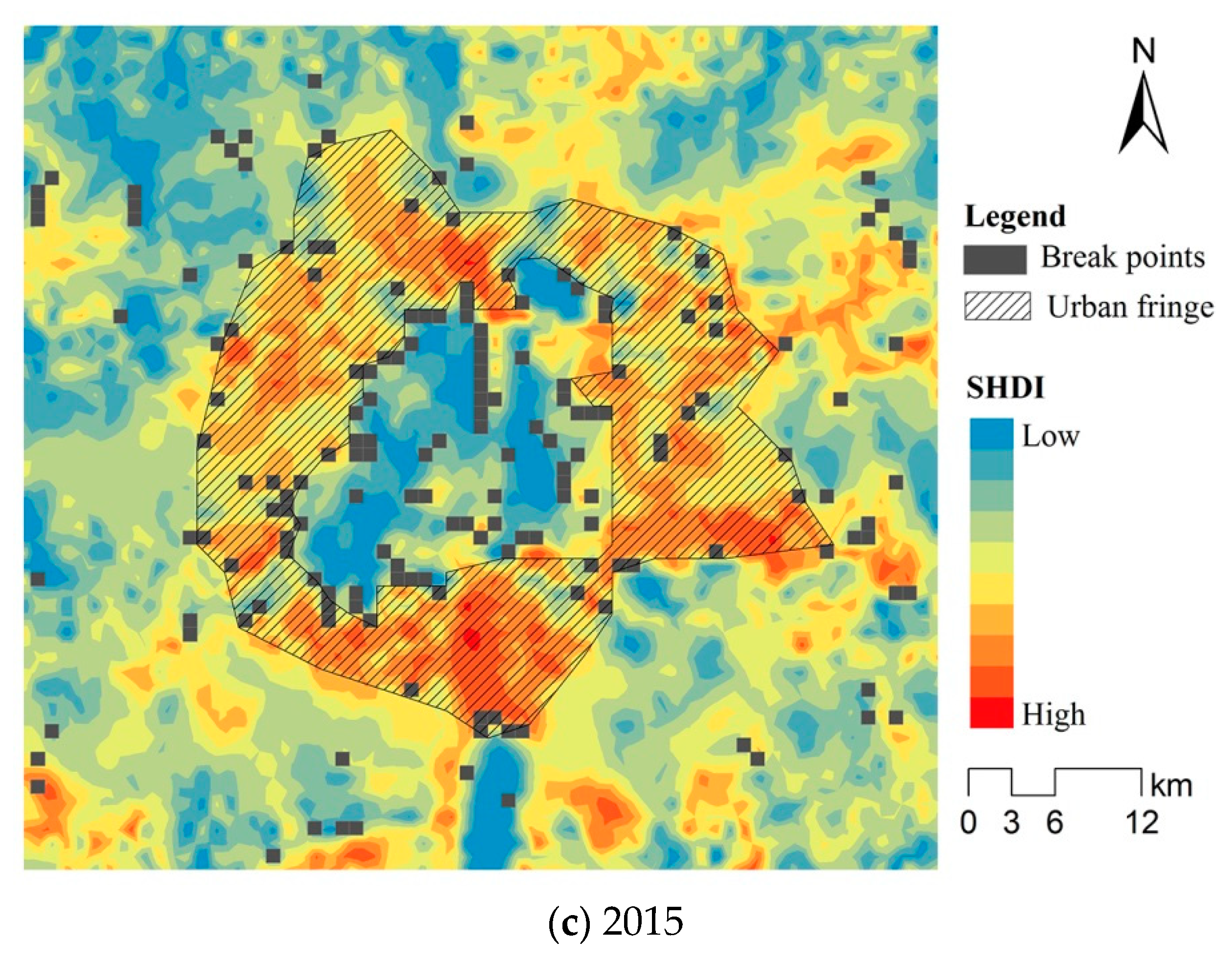
To analyze the expansion pattern of the urban fringe in different directions in the study area and explore the factors that affect the expansions of urban fringe, eight expansion directions were compared (
Figure 8): E, NE, SE, south (S), SW, W, northwest (NW), and north (N).
From 1995 to 2005, the outlying expansion mainly occurred in the E, SE, and S directions. The area of eastward expansion was 135.39 km2, which accounted for 21.23% of the total expansion area. The main areas of infilling change were concentrated in the W, SW, and NW directions. The region converted to core area was mainly located in the SE, which accounted for approximately 23.99% of the total converted area.
From 2005 to 2015, the urban fringe area mainly extended northward with an area of 40.09 km2, which accounted for 27.75% of the total area. Except for the NE direction, the amount of infilling in the remaining directions was all large. The top two values of the core area conversions toward the NE and E directions were 26.62 and 26.12 km2, respectively.
In general, during 1995–2015, the urban fringe area of Changchun mainly extended to the E, SE, and N directions. The infilling changes mainly occurred in the W and SW parts of the city. The amounts of urban fringe converted into core area in the SE and S parts of the city were the top values (
Figure 8).
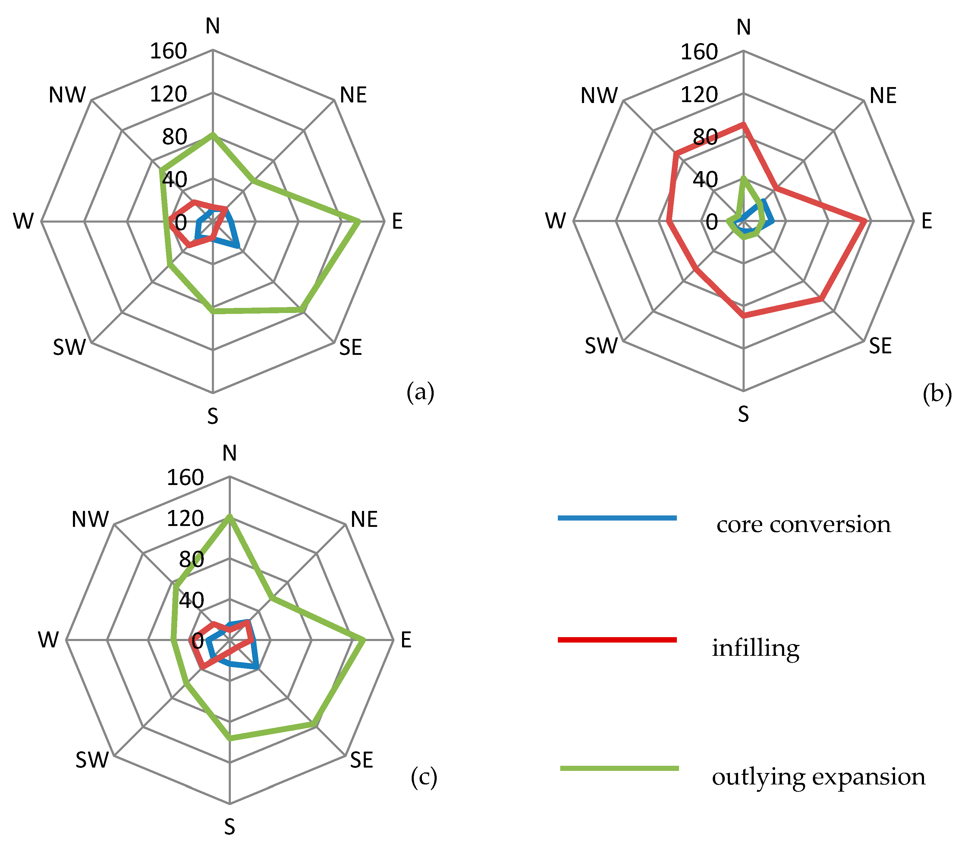
A development zone refers to a specific area of a country or region to attract external factors of production, promote its own development, and implement special policies and management in a certain area. The development zone plays an important role in the development of Changchun City. In 1991, Changchun City established high-tech development zone. The Economic and Technological Development Zone was set up in 1993, and the Jingyue Tourism Development Zone was established in 1995. In 2016, the State Council further approved the establishment of Changchun New Area (
Figure 9). Usually, enterprises in the development zone can get land use rights at lower prices and enjoy tax concessions. As the development zone has preferential policies for investment and construction, it has promoted the agglomeration of enterprises and population in the region. The exuberant demand for land is the main factor that causes the urban fringe of Changchun to expand to the E, SE, and SW during 1995–2015. The direction of urban fringe expansion is closely related to the distribution of development zones.
The urban master plan of the 1995 edition suggested that the urban layout structure adopts the decentralized group style, and clearly put forward the transfer of urban development from the center to the fringe, from the old urban region to the new area. The urban master plan of the 2005 edition put forward the spatial structure of “dual-core, multi-level and eight areas”. “Dual-core” refers to the establishment of new town in the southern part of the city. Under the guidance of this plan, Changchun extended to the south. In 2011, the master plan of Changchun put forward the urban spatial structure of “dual-core, two wings and multi-group”, transferred some functions of the central urban area to other areas, and formed two urban centers in the central and southern part. The planning of urban spatial structure leads the city to expand towards the S and the E, and promoted the expansion of the urban fringe in the SW, SE, and E.
The development of the economy has promoted the construction of the road in the region. The road is the main medium to contact the cities and peripheral areas. The expressway in the E of Changchun is dense and also promotes the expansion of the urban fringe area of Changchun to the E.
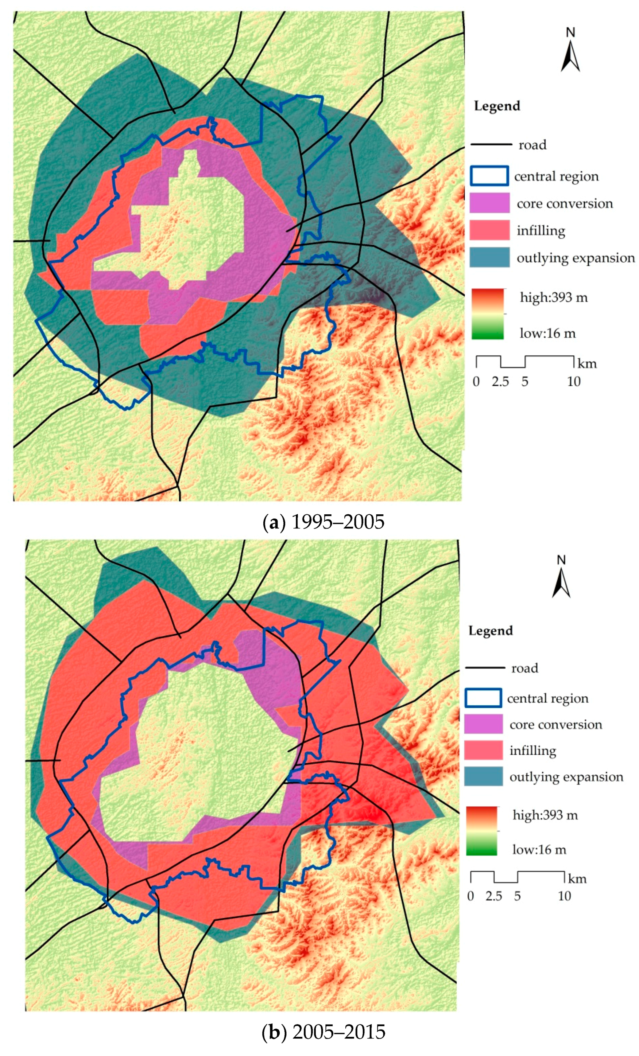
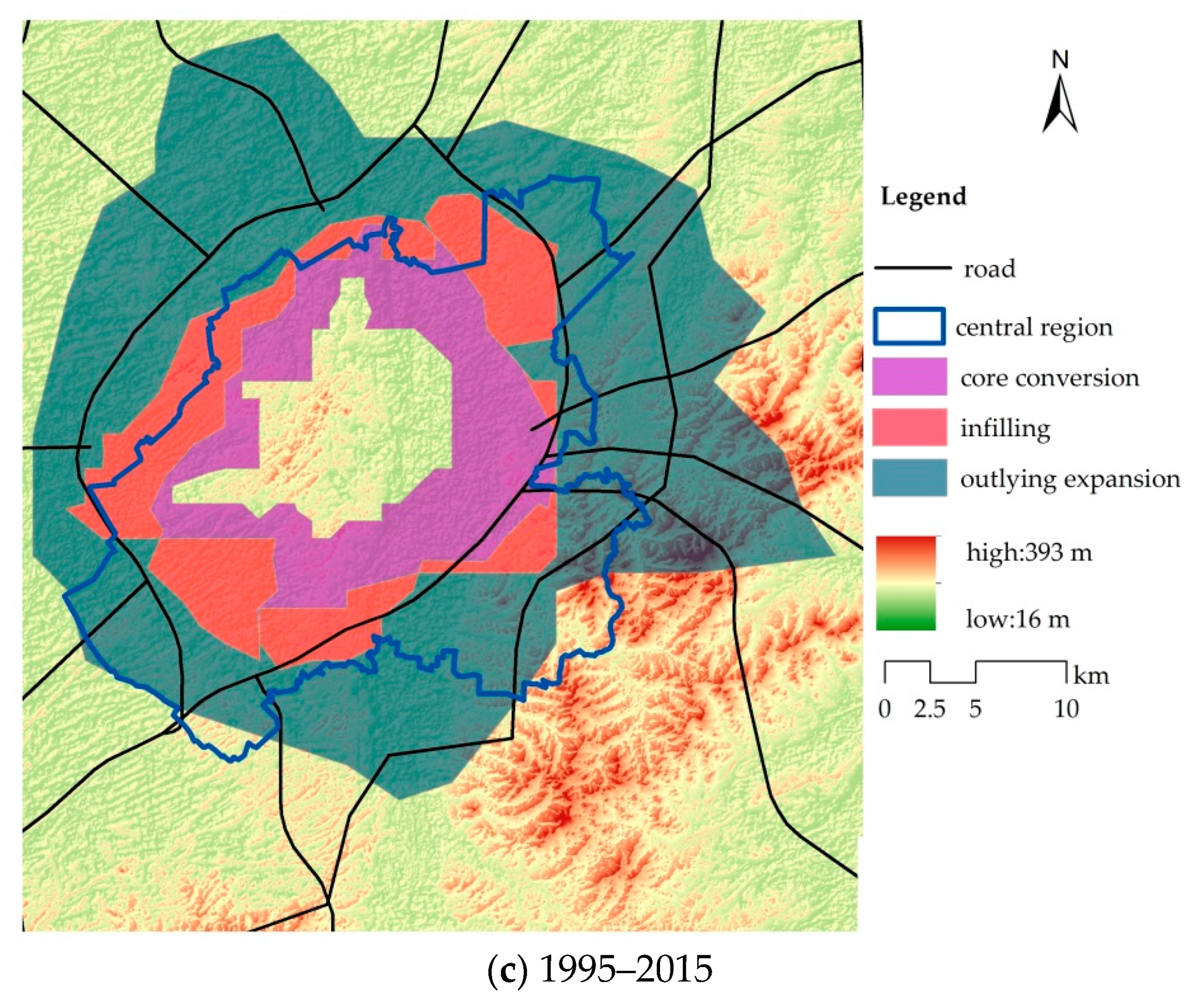
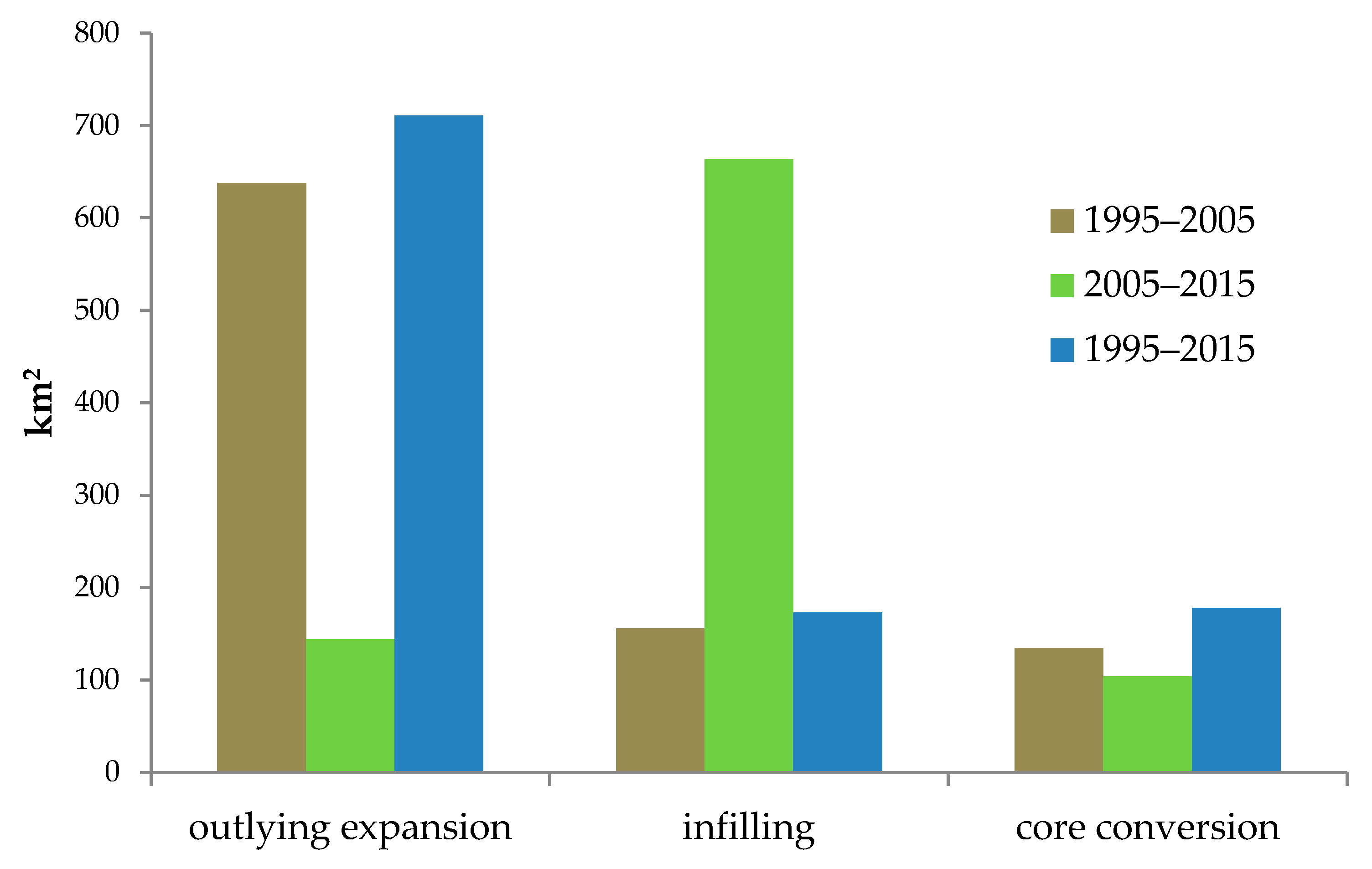
4.4. Change Mode
On the basis of existing research, the expansion of the urban fringe area is divided into three types. The outlying expansion type is transformed from the rural hinterland of the previous period into the region of the urban fringe of the current period. The infilling type depicts a region belonging to the urban fringe area between two periods (previous and current). However, in the interior, where land use type changes have happened, the core conversion type is an appropriate descriptor, that is, the transformation from an urban fringe to a core area of the city [
14,
35].
In general, from 1995 to 2015, the main change type of the urban fringe was outlying expansion. The number of urban fringe areas converted into core areas was considerably smaller than the increase in urban fringe area (
Figure 10). The characteristics of topographic relief are often the basic skeleton of the large-scale regional distribution pattern. During 1995–2015, the restraining effect on the urban spatial expansion of Changchun is becoming increasingly prominent. The eastern part of Changchun City is a hilly land, and the land available for urban use is reduced. The infilling changes in the urban fringe increased in the SE direction.
From 1995 to 2005, the urban fringe of the outlying expansion reached 637.78 km
2, which accounted for 82.50% of the total urban fringe in 2005. The infilling area was 155.70 km
2, which accounted for 57.7% of the total area in 1995. A total of 134.48 km
2 of urban fringe was transformed into a core area, which accounted for 51.14% of the total core area in 2005. In this phase, the urban fringe change mode was dominated by outlying expansion (
Figure 11).
From 2005 to 2015, the urban fringe of the outlying expansion reached 144.49 km
2, which accounted for 18% of the total area in 2015. The infilling area was 663.62 km
2, which accounted for 85.85% of the total area in 2005. The urban fringe area transformed into a core area covering 177.80 km
2, which accounted for 48.43% of the total core area in 2015. In this phase, the urban fringe area was dominated by infilling types (
Figure 11).
The characteristics of topographic relief are often the basic skeleton of the large-scale regional distribution pattern. During 1995–2015, the restraining effect on the urban spatial expansion of Changchun became increasingly prominent. The eastern part of Changchun City is hilly, and the land available for urban use is reduced. The infilling changes in the urban fringe increased in the SE direction.
4.5. Changes in Urban Fringe Fragmentation
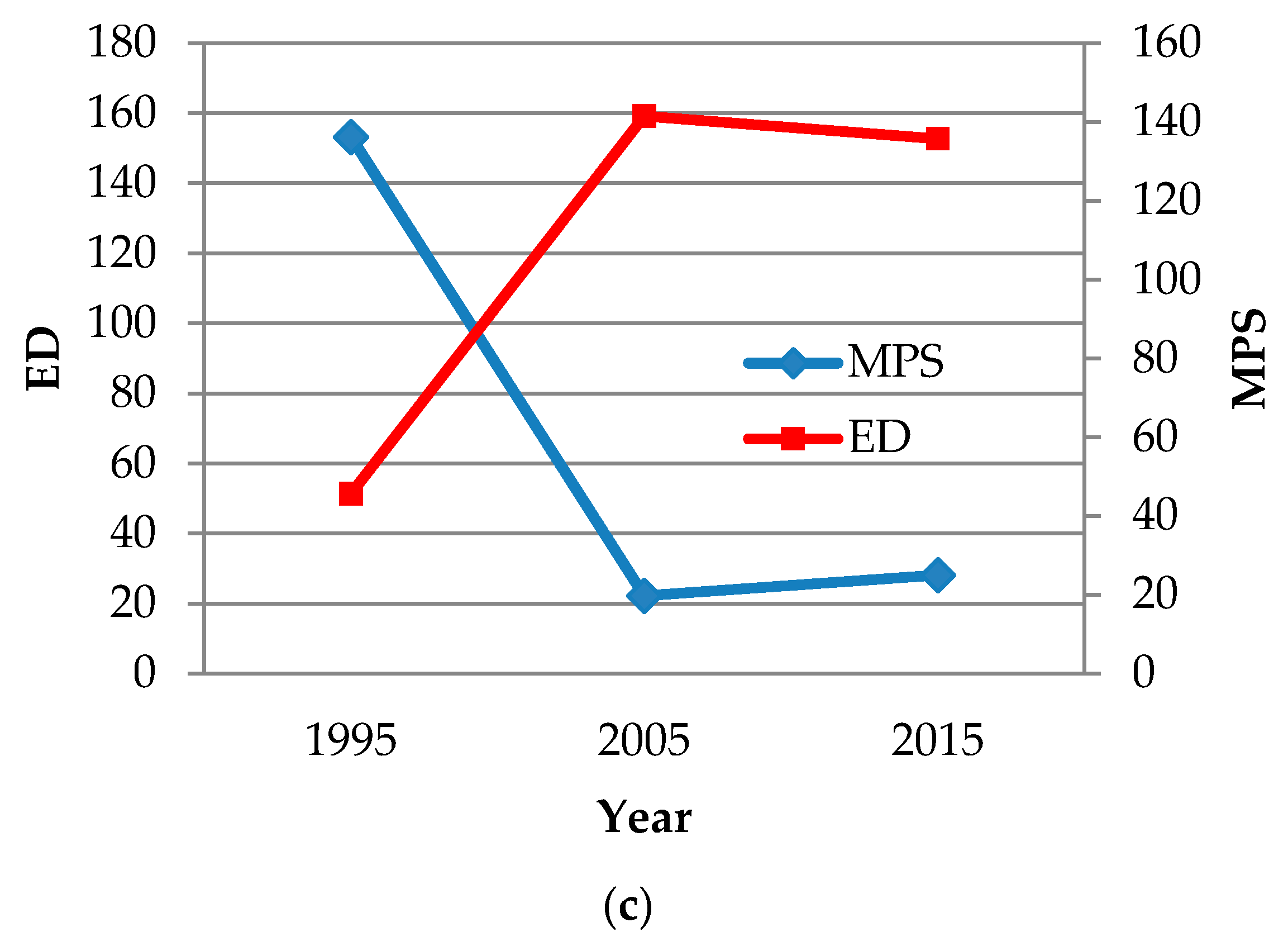
The land uses and landscapes in the urban fringe area have unique characteristics. The process involved outlying expansion, infilling, and core conversion, and thus, the inner landscape of the urban fringe changed significantly.
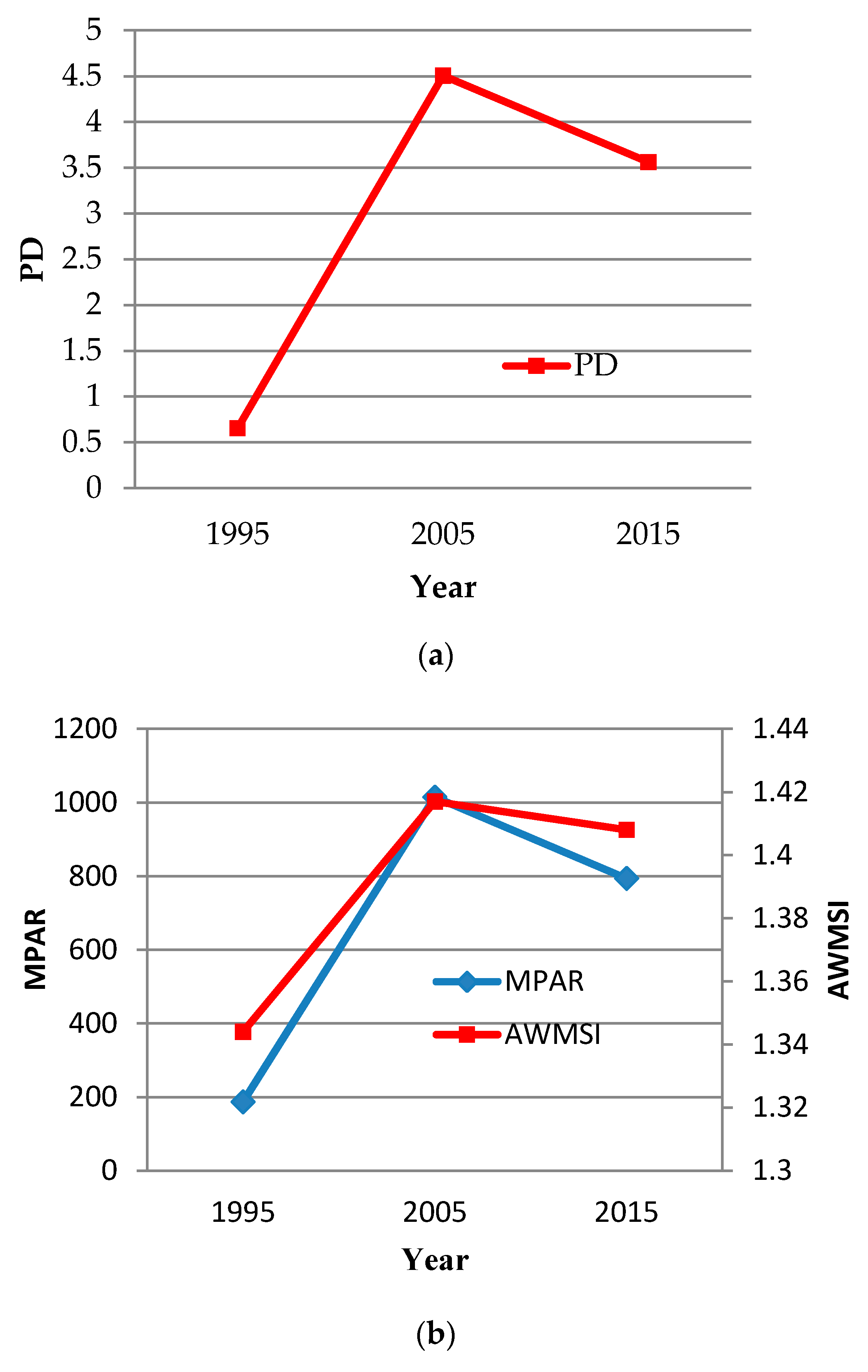
Figure 12 shows the change rate from using the previously selected landscape metrics above. PD values increased sharply and declined slightly, whereas MPS values declined sharply and increased slightly from 1995 to 2005, which indicates that human activities significantly influenced the urban fringe during this period. The original types of land use changed, the density of patches in the urban fringe increased, and the average patch area decreased. Moreover, the relatively dense patches and the increased average patch sizes from 2005 to 2015 indicate that land use in the urban fringe areas has shifted from disorderly to orderly development.
MPAR, AWMSI, and ED values increased sharply and declined slightly from 1995 to 2005. Land fragmentation resulted in irregularly shaped land patches, but the patches started to develop regularly from 2005 to 2015. In accordance with the results of the landscape indicators, the landscape of Changchun’s urban fringe is significantly affected by urban expansion, which reflects the utilization process of the natural landscape from disorderly to orderly development. The landscape index shows that the urban fringe area of Changchun has experienced two stages: the urban growth speed was high during 1995–2005, and disordered. However, during 2005–2015, the available land around settlements reduced. Attention has been paid to the value of land use at the edge of the city, and orderly development and construction have begun.
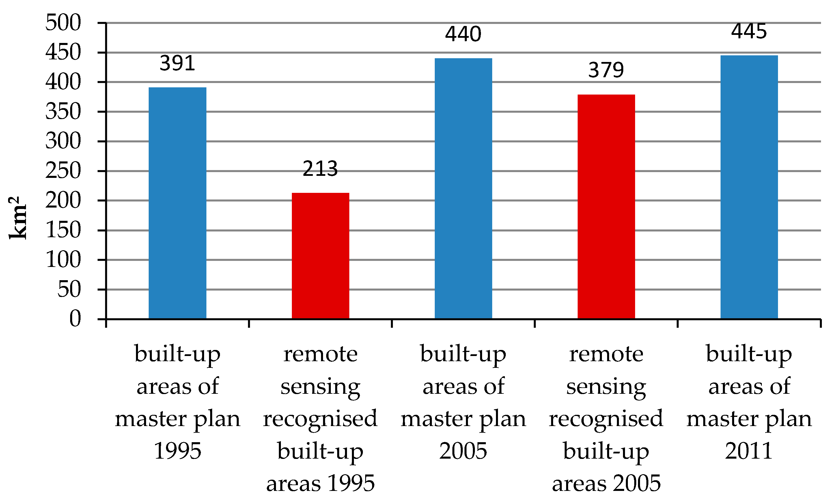
Under the current land management system in China, the scale of urban construction land cannot exceed the provided quantity of the master plan. In the master plan of Changchun in 1995, the land allowed for construction was 391 km
2, and the built-up area recognized by remote sensing was only 213 km
2. Changchun had sufficient land for construction, and the land use in the urban fringe was disorderly. By 2005, the built-up area recognized by remote sensing had reached 379 km
2, which was close to the upper limit of the area provided in the master plan of 1995. The master plan of the new edition adjusted the permitted area to 445 km
2 in 2011. During 2005–2015, only 66 km
2 could be used for construction in Changchun (
Figure 13). Overall, from 2005 to 2015, the land available in Changchun was scarce, and the infilling growth in the urban fringe areas provided valuable land for urban construction.
4.6. Implications for the Construction of Changchun New Area
The available land around the central urban area is insufficient. With the establishment of Changchun New Area, a large amount of construction land has been provided for Changchun, and the city will expand to the NE. A new urban fringe will appear. In the past, urban construction land planning belongs to the Planning Bureau, farmland pertains to the Land Bureau, woodland and wetlands correspond to the Forestry Bureau, and grassland is associated with the agricultural sector. The spatial planning is inconsistent, and the problem in the urban fringe is further prominent. In 2018, the State Council promoted institutional reform, set up the Ministry of Natural Resources, and proposed that a unified spatial planning system should be established. In the future development of Changchun New Area, attention must be paid to the sustainable development of land use in the urban fringe area.
5. Conclusions
An urban fringe area is a region where both social and environmental problems are concentrated. The identification and evaluation of urban fringe spatial distribution are the foundation for this work. China is in a state of rapid urbanization. On the basis of the land use data extracted from remote sensing data, identifying the urban fringe area with SHDI and the breakpoint method is reliable, and the results can be used as a reference for urban fringe studies in other cities.
Changchun, similar to other cities, is undergoing rapid growth. In this study, three types of land use data were extracted from remote sensing images. On the basis of the entropy information of land use, the scope of the urban fringe of Changchun City in 1995, 2005, and 2015 was identified with the breakpoint method. The changes in the number of urban fringe areas, the change mode, and the changes in landscape metrics in the urban fringe were evaluated.
Policy and planning are the main factors influencing the development of Changchun fringe area. Since 1991, the establishment and construction of three development zones in Changchun have affected the expansion direction of the urban fringe area. From 1995 to 2015, the urban fringe areas mainly extended to the E, SE, and N. The changes in infilling type mainly occurred in the W and SW, and the core conversion areas were mainly in the SE and S. The results from the landscape metrics indicate that the landscape within the urban fringe transformed from fragmentation to regularization, and the development of the urban fringe transformed from a disorderly to an orderly manner. This condition is mainly due to the reduction of available land because the area of urban construction land was controlled by the master plan of the city.
The present work hopes to provide basic support for the study of urban fringe social and environmental problems and urban planning. The reasons for the changes in urban fringes differ, and the problems in urban fringe are complex. This study is insufficient for the quantitative analysis of factors affecting urban fringe changes. With historical and fine-scale social and economic data, the reasons and effects of urban fringes are worth studying in the future. Moreover, through the prediction of future urban land use change, evaluating the future changes of urban fringe areas is also meaningful.


