Abstract
OpenStreetMap (OSM), based on collaborative mapping, has become a subject of great interest to the academic community, resulting in a considerable body of literature produced by many researchers. In this paper, we use Latent Semantic Analysis (LSA) to help identify the emerging research trends in OSM. An extensive corpus of 485 academic abstracts of papers published during the period 2007–2016 was used. Five core research areas and fifty research trends were identified in this study. In addition, potential future research directions have been provided to aid geospatial information scientists, technologists and researchers in undertaking future OSM research.
1. Introduction
OpenStreetMap (OSM), founded in 2004, provides a free editable guide to the world, available under an Open Database License (ODbL). The project is supported by Web 2.0 technologies, which enable more coordinated efforts among web clients, different users and content suppliers [1]. These technologies render new methods for sharing information [1,2,3] by crowdsourcing developments such as Wikipedia [4]. In the context of geographic information, crowdsourcing is also known as Volunteered Geographic Information (VGI) [5] or collaborative mapping [6], where websites such as Wikimapia and OSM [7] are good examples. The volunteers contributing towards OSM use various devices to record GPX tracks and edit the information using online editors (e.g., iD3, Potlatch) or offline editors (e.g., JOSM) [8].
The VGI researcher community has focused on devising methods and tools for the utilization of volunteered data. During the last decade, OSM has gained in maturity, and numerous papers on different aspects of OSM have been published. In particular, a trend towards the analysis and fitness-for-use of OSM in various application domains has been witnessed. However, such research trends are not well understood, and hence, it is important to identify them. Manual systematic reviews [9] or semi-automated topic modeling algorithms [10,11,12] are two methods that can be employed. Systematic reviews are more critical and can be biased, whereas semi-automated methods are more generic in finding the trends [13]. A comprehensive review has been published by Senaratne et al. [14], which focuses on text-, map- and image-based VGI, but this study involved a manual review of 56 papers describing quality assessment methods. In contrast, this current study uses a quantitative approach called Latent Semantic Analysis (LSA), which is a well-established method. LSA has been used previously by See et al. [15] to analyze trends in VGI, but the focus of our study is specifically on OSM. Hence, in this paper, we apply LSA to 485 abstracts of research papers published during the period 2007–2016 with the aim of discovering the core research areas of OSM, the trends and their relationships. In addition, we suggest future research directions. This set of 485 papers is considered sufficiently large enough for performing text-mining as explained in Evangelopoulos et al. [12]. On the basis of this study, five core research areas and fifty research trends have been identified.
A secondary aim of this study is to try to answer the following research questions framed by Kitchenham et al. [16]:
- RQ1:
- Who is leading OSM research?
- RQ2:
- Which research areas have been widely investigated by researchers?
- RQ3:
- How has the focus of topics within each core research area changed over time?
- RQ4:
- What are the potential future directions of OSM research?
This paper is divided into six sections. The next section describes the methodology adopted for collecting the research literature, as well as the steps undertaken in the application of the LSA approach. The third section discusses the results obtained from different topic solutions and maps the research trends to core research areas. The fourth section answers the research questions, while the fifth section considers the limitations of the study. The conclusions drawn from the findings of the study are provided in the last section.
2. Materials and Methods
2.1. Data Acquisition
Various bibliographic databases were used to collect the literature dataset. The articles were selected using “OpenStreetMap (OSM)” OR“volunteered geographic information (VGI)” OR “crowdsourced map” as search keywords. The open-source tool JabRef [17] was used for the purpose of the collection, screening, selection and corpus preparation. Bibliographic databases searched included IEEExplore, ScienceDirect, the DBLP computer science bibliography, ArXiv, Directory of Open Access Journals (DOAJ), Association for Computing Machinery Digital Library (ACM DL) and CiteSeerX. In addition, a manual search of Taylor and Francis, Wiley, the MDPI journal bibliographic database and the Zotero repository was undertaken, and any relevant literature found was added to the collection. The assembled literature was then manually reviewed in JabRef to identify the articles based on inclusion and exclusion criteria set out in Table 1. The elimination of duplicate articles or those that were out of focus, as described in Table 2, resulted in 485 articles in the final literature dataset. This dataset included nineteen papers converted from German, Spanish and Italian to English. The dataset was exported to a csv (comma-separated value) file using an export filter, purposefully designed for JabRef [18]. The exported file included titles, abstracts and year of publication.

Table 1.
Inclusion and exclusion criteria.
Table 2.
Paper count during various steps of data acquisition.
Figure 1 presents the distribution of publications over time. Based on the number of occurrences in the dataset, the top researchers with the most publications on OSM during the period 2007–2016 and the top fifteen journals publishing articles related to OSM are presented in Table 3 and Table 4, respectively.
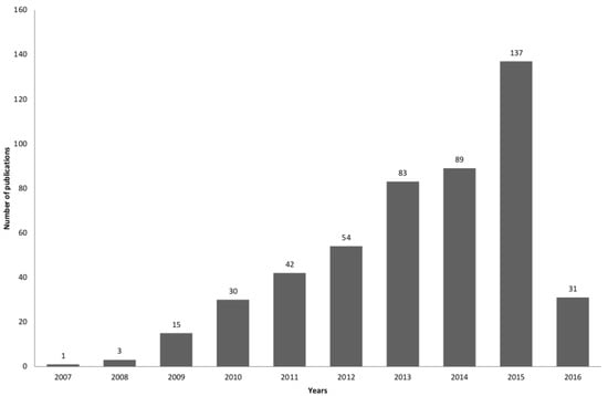
Figure 1.
Publications by year during the period 2007–2016.
Table 3.
Top researchers in OSM research.
Table 4.
Top fifteen journals focusing on OpenStreetMap (OSM).
2.2. Application of Latent Semantic Analysis
The literature dataset described in Section 2.1 was provided to the LSA model for uncovering the “latent” semantic structure [19,20,21]. LSA, which is a natural language processing approach, provides a methodology for automatically organizing, understanding, searching and summarizing a textual dataset. It examines the relationship between documents and terms in the dataset to reveal concepts. It is an unsupervised text-mining approach that uses Singular Vector Decomposition (SVD) to create a low-dimensional space for finding relationships, revealing topics and comparing documents [13,19,22,23,24,25,26]. Moreover, it is an established approach for identifying research trends prevailing in a large literature dataset [12,20,27,28]. Recommendations for application of the methodology were taken from Evangelopoulos et al. [12]. Since the aim of the study was to find the latent structure of the corpus, the factor analysis extension to LSA was applied using the fast truncated incremental stochastic SVD algorithm with a single pass [29,30].
The application of LSA produces two matrices, namely a term-loading and a document-loading matrix. The term-loading matrix represents the topics and associated highly-loaded terms. The document-loading matrix represents topics and associated highly-loaded documents. Higher loading values indicate greater familiarity with a topic [13]. Table 5 shows a five topic solution representing five latent classes, associated keywords and their labels. It also presents the highly-loading terms in the term-loading matrix, generated from an empirical analysis after the application of the LSA to the literature dataset. The detailed procedure followed for the semantic analysis is discussed in the following sections.
Table 5.
Five topic-based term loading tokens.
2.3. Pre-Processing and Term-Filtering
The first step in the corpus preparation was pre-processing and term-filtering. Pre-processing of the literature dataset is a vital part of any text-mining algorithm. The characters, words and sentences discovered during the pre-processing step act as tokens for further processing by the LSA. This step helps to reduce the size of the dictionary and improves the efficiency and effectiveness of the text-mining approach [31,32]. This involved the removal of names, numbers, abbreviations, slang, acronyms, punctuation and N characters as recommended by Evangelopoulos et al. [12]. The following steps (developed in Python using Natural Language Toolkit (NLTK) http://www.nltk.org) were followed for corpus preparation:
- Sentences (titles and abstracts) for each publication (document) were tokenized.
- Tokens in each document were converted to lowercase letters.
- Punctuation including periods, exclamation points, commas, apostrophes, question marks, quotation marks and hyphens were eliminated.
- The numbers were filtered to contain only textual terms.
- N-character filtering was performed to filter all those terms that consist of words with less than three characters.
- English stop-words (stop-words of nltk python package) and the common keywords in all of the publications (“OpenStreetMap”, “Volunteered”, “Geographic”, “Information”, “Crowdsource”, “Maps”, “OSM”, etc.) were removed. The dataset was then further refined to remove terms that exist only once in a document. These terms were local to a particular document and were considered insignificant [33].
- The SnowballC stemmer algorithm was applied to convert inflected words to the base stem of the tokens in each document.
Initially, the dataset had 87,348 tokens. After the pre-processing step, the token count was reduced to 2510. In this study, 485 sparse vectors were created with the 2510 tokens. A dataset of 485 documents was thus converted to a vector space, where the rows represented the 2510 terms (dimensions) of the 485 columns, each of which corresponds to an article. Each document was then converted to a representation called “bag-of-words” [33]. This mapping process converted each term in the document to its integer Identity (ID), along with its count of occurrences in each document producing a dictionary. This dictionary was given to the next step of the process to create a weighted matrix.
2.4. Term Frequency-Inverse Document Frequency
A TF-IDF weighting scheme was utilized to reflect the significance of a given entity in comparison to other entities (term or document) in the corpus. It increased the weight in proportion to the number of occurrences of a word in the document, but was often offset by the frequency of the word in the corpus. This helped to adjust the weight of some words appearing more frequently [13]. Furthermore, it resulted in a better topic analysis [12,34,35]. Various combinations of TF-IDF weighting schemes can be applied [36,37]. The approach followed in this study is represented in Equation (2), where , , and describe the TF-IDF weight obtained, the term frequency, the number of documents where the term appeared and the number of documents in the dataset, respectively. The term frequency (Equation (1)) represents the local component of a document and measures the frequency of occurrence of a term in a document; the inverse document frequency contains the global component by explaining the importance of a term in the document collection, i.e., .
For driving the term-document weighted matrix, a local-component (term frequency) was multiplied with a global component (inverse document frequency). Using the weighting scheme given in Equation (2), a 2510 × 485 term-document weighted matrix was created for the ith term in the jth document of the corpus of documents. The same weighting scheme was used in all of the identified topic solutions.
2.5. Singular Vector Decomposition
The prepared TF-IDF weighted matrix was provided to the fast truncated SVD in order to perform rank lowering. The SVD model performed factorization of matrix X into variables: initial rotation U, scaling and final rotation V [19,30,38,39] as described in Equations (3) and (4).
The mathematical expression and provided the term-loading; and document-loading with respect to the topics and represented by the weights of the topics (singular values) in a descending order. The maximum number of topics generated was equal to the number of documents in the corpus. For extracting a few topics (k), the topmost k singular values were taken from the matrix [12,40].
2.6. Dimensional Reduction: Selecting Optimal Topic Solutions
Dimensional reduction is a process of selecting k largest singular values from the singular matrix obtained by applying SVD. Selecting an optimal dimensional reduction has always been an open issue [12], which requires extensive understanding and iterations to reach the optimal value. A low value of k dimensions is not sufficient to represent relationships between the terms and documents, whereas a large value induces noise.
As discussed by Deerwester et al. [19], Bradford [41] and Dumais [26], the optimal number of topic solutions for 1000 documents is approximately 100. Based on their recommendations, a fifty topic solution was considered optimal for depicting the research trends in OSM; in addition, three, five and ten topic solutions were considered to describe the core research areas.
2.7. Selecting Threshold Values for Topic Solutions
The term-loading and document-loading matrices consisted of corresponding weights for uncovered topics, i.e., each cell of the matrix (term-loading and document-loading) represented the loading value corresponding to the term/document (row-wise) and topic (column-wise). The values in the loading matrices were both positive and negative. For interpreting the results, varimax rotation [42,43] was performed on both matrices. This resulted in increased loading for one topic relative to other topics [13,20]. The number of documents loaded for a particular topic describes the proximity to that topic. To distinguish between significant and insignificant loading, a heuristic approach called an empirical tail distribution was applied to select the threshold values as discussed by Sidorova et al. [20] and Yalcinkaya and Singh [13]. For instance, to define the threshold values of documents for a ten topic solution, the loading values of (485) documents in each (ten) topic were transformed to a vector (a one-dimensional matrix with 4850 elements) from its matrix form. After sorting this vector in descending order, the threshold value was obtained by retaining the th term of high-loading values of this vector. As per the calculations performed by the tail distribution, the threshold values for three, five, ten and fifty topic solutions were 0.133, 0.142, 0.162 and 0.183, respectively, for document loadings. Thus, any document having a loading of less than these values was considered insignificant for the topic. Furthermore, the terms and documents were loaded to only one topic.
2.8. Topic Labeling
The loading values in the term-loading and document-loading matrices were sorted in a descending order. An iterative approach was followed for topic labeling by examining highly loaded key-terms in the term-loading matrix and documents in the document-loading matrix for each topic solution. The highly-loaded values were grouped together for creating a sensible label for each topic as shown in Table 6, Table 7 and Table 8. The topic labeling was subject to the possibility of human bias as the degree of topical coherence varied significantly.
Table 6.
Core research areas for OSM.
Table 7.
High-loading research papers for five topic solution.
Table 8.
Research trends for OSM.
3. Results
3.1. Summary of Topic Solutions
The application of LSA resulted into three, five and ten topic solutions presented as core research areas, which are presented in Table 6 along with the topic labels and the number of publications for three different time periods within 2007–2016. Topic solutions are represented as , which denotes the jth factor of the ith topic solution, e.g., T10.4 represents the fourth factor of the tenth topic solution. The number of articles associated with a particular topic solution represents the importance of the corresponding research area within that topic solution. The mapping presented in Table 9 shows the semantic connections between the core research areas and the trends established using the cross-loading analysis.
Table 9.
Mapping of core research areas and trends.
3.2. Core OSM Research Areas
The core research areas exhibited in Table 6 for the three topic solution focused on “quality assessment and analysis” (T3.1), “routing and navigation” (T3.2) and “miscellaneous” (T3.3). These articles emphasized the development of methods for the quality assessment of crowdsourced data and issues pertaining to routing and their applications.
The core research areas that emerged in the five topic solution were “quality assessment and analysis” (T5.1), “assessment of contributors’ behavior” (T5.2), “applications to navigation and disaster” (T5.3), “traffic simulation and mobility” (T5.4) and “indoor navigation models (T5.5)”. The five highly-loaded documents for each topic along with the loading values are presented in Table 7.
The ten topic solution uncovered three trending areas, viz. “algorithmic model development” (T10.3), “semantic similarity” (T10.5) and “indoor navigation models” (T10.7). “Quality assessment and analysis” (T10.1) was a dominant research area throughout the period 2007–2016. The research area “assessment of contributors’ behavior” (T10.2) also became a trending area of research during the period 2012–2016.
The results revealed that numerous high-loading publications converged to one research area, i.e., “quality assessment and analysis” in the three, five and ten topic solutions. This is because OSM was originally developed in response to the high cost of government data so representing an alternative source of open information. Hence, it is unsurprising that OSM has been compared to numerous proprietary map datasets. This topic appeared across (T3.1)–(T10.1), but the number of high-loading documents has decreased as new topics have emerged from the corpus. There has been an extensive discussion on quality assessment of OSM data since the year 2008 to understand the fitness of the data in various application areas [69]. Researchers have applied various established data quality indicators [70,71,72,73,74,75] for the assessment and analysis of OSM data. The evolution of OSM and its assessment in different regions of the world, particularly Europe, the USA and China, has been observed. The established assessment methods of comparing OSM data against authoritative data are not always feasible [14,76]; thus researchers have explored intrinsic quality indicators to assess OSM data.
3.3. OSM Research Trends
The fifty topic solution uncovered OSM research trends as presented in Table 8 with a count of highly-loaded papers for a particular topic solution. Papers with a loading value of 0.183 or more were considered relevant for a particular topic. The distribution of highly-loaded articles presented in Table 8 shows that the “quality assessment” (T50.1) trend emerged as being highly explored in the fifty topic solution. This was consistent with the three, five and ten topic solutions, with 185 papers contained in this topic solution. Some of the highly-loaded papers compared OSM data with other authoritative and proprietary datasets [7,45,47,48,77,78,79,80,81,82,83,84,85,86,87,88,89,90,91,92,93,94,95,96,97,98,99,100,101] based on data quality parameters as suggested by Guptill [73] and Longley et al. [72]. Others reported on the analysis and implementation of frameworks for the assessment of OSM data [102,103,104,105].
The research trend “land-use patterns” (T50.6) was reported in thirteen articles that were focused on the use of OSM in remote sensing applications, particularly land use mapping [106,107,108,109,110,111,112,113,114]. Another trend that emerged was “indoor navigation” (T50.2), which focused on mobile enabled indoor navigation in transport services [65,66,115] and their augmentation with floor plans [68].
The “traffic simulation and management” (T50.4) trend uncovered the use of evolutionary methods to calculate real vehicle flows in cities [61,116] using Simulation of Urban Mobility (SUMO), the use of data mining techniques in the field of traffic simulation [59] and the development of models in SUMO and MATSim for traffic simulation and management using VANETs-based applications and protocols [62,117,118]. Another research trend that emerged related to traffic was “smart cities and mobility” (T50.8). These papers focused on traffic regulation using evolutionary algorithms to reduce travel times and greenhouse gas emissions [60,119,120,121]. The “shortest path computation” (T50.16) research trend revealed the use of shortest path algorithms [122,123] and the application of Hadoop to solve the shortest path problem in large complex datasets [124,125]. The trend of “OSM for routing” (T50.11) provided an analysis for checking the richness of vehicle routing [126] and routing with the fewest-turn map directions [127].
Another significant research trend that emerged was “disaster management” (T50.13), where OSM has played a vital role in disaster management efforts and has been utilized by community-based disaster response organizations and researchers. OSM is used in the simulation of impact modeling and disaster readiness analysis. Papers in this theme focused on the applications and case studies of OSM during the Haitian earthquake [57], the assessment of OSM for disaster management [128], and for development of a location-based early warning and evacuation system [129]. The trend “haptic for navigation” (T50.9) uncovered the use of haptic tools for navigation. The published papers concentrate on such tools and the exploration of street networks [54,55,56,58,130]. The research trends “contributors’ pattern” (T50.26) and “trust in OSM data” (T50.23) provided answers to the motivation of contributors, patterns and trust in OSM data. Other important research trends uncovered in the fifty topic solution were “location-based services” (T50.18), “data mining approaches for OSM data” (T50.33), “conflation of maps” (T50.29) and “OSM for autonomous navigation” (T50.39). From Table 8, it is clear that research activities in the field of OSM increased tremendously during the period 2012–2016.
3.4. Mapping of Core Research Areas and Research Trends
Table 9 presents the mapping of core research areas and trends. A manual connection was established between core research areas and trends on the basis of high-loading papers for the topic solutions as discussed in a number of studies [13,20,131]. The mapping presents the relationship between low-aggregated topic solutions with highly-aggregated topic solutions by referring to the minimum loading value (threshold). In the current study, most of the articles clustered around one topic, i.e., “quality assessment” (T50.1). This effect may be attributed to the use of dominating keywords in these articles. For instance, the topic “land-use patterns” (50.6) revealed thirteen articles [106,107,108,109,110,111,112,113,114,132,133,134,135]. From these, eleven articles emerged from “quality assessment and analysis” (T5.1), whereas two of the papers were focused on “assessment of contributors’ behavior” (T5.2) [110] and “indoor navigation models” (T5.5) [107], respectively. Hence, based on the high-loading articles, the research trend “land-use pattern” (T50.6) was mapped to the core research area of “quality assessment and analysis” (T5.1). The detailed discussion is presented in the following sections.
3.4.1. Quality Assessment and Analysis (T5.1)
This research area has been explored the most. Table 9 shows that out of fifty topic solutions, thirty eight topics emerged from this research area that focus on two distinct categories. The first category focused on assessment and analysis of OSM data while the second was related to the application of OSM data for analysis in various GIS domains.
The research trends such as “quality assessment” (T50.1), “road matching algorithms” (T50.7) [136], “assessment of building models” (T50.15) [137], “shortest path computation” (T50.16) [122,125], “automated comparison”(T50.17) [47], “estimating building types” (T50.25) [138], “conflation of maps” (T50.29) [139], “managing OSM tags” (T50.30) [140], “data mining approaches for OSM data” (T50.33) [141,142], “automatic scale assignment to OSM features” (T50.35) [143], “matching POIs” (T50.36) [144], “integration and transformation for borderland analysis” (T50.37) [145], “computer vision-based methods for data generation” (T50.42) [146], “assessment of geocoding services” (T50.43) [147], “evaluation of mapping APIs” (T50.46) [148], “automatic recommendation OSM categories” (T50.48) [149], ”enriching turn restrictions” (T50.49) [150] and “polygon inspection in XML data” (T50.50) [151] showed a range of analyses of 2D and 3D map data. The research area further uncovered generation of interactive 3D city models for OSM [152,153,154,155], and the assessment of 3D models for positional accuracy of linear features [156].
The other research trends, i.e., “land-use patterns” (T50.6) [114], “OSM for routing” (T50.11) [126], “OSM for wireless sensor networks” (T50.12) [157], “location-based services” (T50.18) [158], “OSM for generating descriptions”(T50.19) [159], “generative models and maps for blinds” (T50.27) [160], “OSM for pervasive applications” (T50.28) [161], “OSM for autonomous navigation” (T50.39) [162], “real time tracking” (T50.40) [163], ”flood modeling” (T50.41) [164], “OSM for traffic generator” (T50.44) [165] and “OSM for situational awareness” (T50.47) [166] used OSM in different application areas and analysis.
3.4.2. Assessment of Contributors’ Behavior (T5.2)
Goodchild and Li [167] have outlined that crowdsourcing can enable a group of individuals to validate and correct the errors that others might have made, which could converge to the truth-based on Linus’ Law [168]. The studies conducted recently have shown that OSM data quality can be judged by assessing contributors’ motivation and patterns [50,78,169]. Haklay et al. [170] have revealed that positional accuracy improves with the increase in the number of contributors. The two research trends that emerged from this core research area were “trust in OSM data” (T50.23) [50,171] and “contributors’ patterns” (T50.26) [172].
3.4.3. Applications to Navigation and Disaster (T5.3)
This core research area provided research trends related to navigation and crisis management during natural disasters. Developer teams around the globe are working on the development of information models for navigation like “mobile-based services” (T50.3) and “haptic for navigation” (T50.9) [54,55,56,58,130], web servers for using map data in crisis situations like “disaster management” (T50.13) [57,128,173], “evacuation modeling” (T50.34) [174,175] and “humanitarian efforts” (T50.32) [176]. The research on the haptic model for navigation has been conducted by Jacob et al. [130] and Kaklanis et al. [58] for developing a multi-modal, haptic and audio feedback interface to vibrate based on the navigation path to assist users by touch. The research trend, viz. disaster management, elaborated on the effectiveness of applications in improving situational awareness, coordination among organizations and emergency response teams. This core research area also uncovered the work of Tully et al. [177,178], who have used OSM to create a 3D virtual environment for improving quality and performance of decision support systems during any such crisis.
3.4.4. Traffic Simulation and Mobility (T5.4)
Simulation of traffic systems has emerged as one of the core research areas where OSM data have been used for solving relevant traffic problems, reducing the travel time of vehicles and smart mobility problems. This core research area uncovered three trends, viz. “traffic simulation and management” (T50.4) [59,61,63], “smart cities and mobility” (T50.8) [60,119] and “reducing travel times” (T50.14) [121].
3.4.5. Indoor Navigation Models (T5.5)
The demand for indoor routing or navigation has increased vastly in recent years. This core research area included “indoor navigation” (T50.2) [65,66,68,115] and “indoor planning and simulation” (T50.5) [64,67]. In these trends, smartphone sensors have been used to acquire real time parameters. Indoor navigation models integrate the acquired data with OSM by using various algorithms to provide navigation inside complex buildings. The research trends on devising methods for indoor navigation using augmented reality [179,180,181,182] and 3D models [183,184] have also been observed during the period 2012–2016.
4. Discussion and Potential Future Directions
In this section, we consider how the results from the LSA can be used to answer the four research questions provided in the introduction:
4.1. RQ1: Who Is Leading OSM Research?
Figure 1 and Table 3 present the top journals and authors publishing on OSM. Journals include the ISPRS International Journal of Geo-Information, Transactions in GIS, International Journal of Geographical Information Science and The International Archives of the Photogrammetry, Remote Sensing and Spatial Information Sciences. The literature is dominated by publications from European researchers. Goodchild [5] and Haklay [2] are two prominent researchers in VGI. The preliminary assessments of OSM data have been performed by Kounadi [7], Ather [77] and Haklay [78]. Leading researchers from research group in GIScience and Geoinformatics have worked on the assessment of OSM [185]; user contributions [53]; indoor-outdoor navigation and location-based services [64]; application and tools for intrinsic analysis [103]; and assessment of land-use information in OSM [51]. Mooney [70] is a leading researcher in OSM and has suggested the need for quality metrics for assessing OSM in the absence of “trusted” sources of ground truth. Other researchers who have identified important topics include: Jacob et al. [56], who have developed a haptic feedback navigation applications for pedestrians; Keßler and de Groot [50], who have discussed issues of the trust in user contributions; Stolfi and Alba [60], who have worked on the use of OSM for smart mobility; Goetz [154], who has developed 3D models with OSM; Ballatore et al. [186], who have utilized LinkedGeoData, developed by Auer et al. [187], and presented a conceptual model for quality assessment and enrichment of OSM data; Ruta et al. [181], who have incorporated augmented reality for utilizing a point-of-interest (POI) discovery-based tool for indoor-outdoor navigation; and Jilani et al. [188], who have brought the concept of machine learning into VGI and presented automatic tag assessment and inference models. More than 90 universities and research groups have developed tools for the contribution to and assessment, visualization and application of OSM.
4.2. RQ2: Which Research Areas Have Been Widely Investigated by Researchers?
The results of the study show that “quality assessment and analysis” has been the most widely investigated topic in OSM research. OSM data quality is a matter of concern due to non-existence of knowledge about the contributors. OSM quality has been assessed on the basis of established quality indicators [71,72,74,189] or intrinsic indicators for VGI in the absence of authoritative datasets [14,76,190] using contributors’ motivation and patterns as inputs [50,169,170,171,191].
From an investigation of this core research area, we have identified the studies focusing on different quality indicators and the methods used for this purpose (Table 10). Positional accuracy, completeness, attribute accuracy, and semantic accuracy indicators have been widely explored by OSM researchers, whereas logical consistency, temporal accuracy, and lineage have gained less attention.
Table 10.
Data quality indicators and methods used.
4.3. RQ3: How Has the Focus of Topics within Each Core Research Area Changed over Time?
The evolution of OSM research can be examined by looking at the shifts in focus across the five core research areas. From Table 8, OSM has clearly gained momentum since the year 2011. The research area “quality assessment and analysis” remained a trending area over the period. This research area is tightly coupled with development of advances in VGI [14,103]. The assessment of OSM data has promoted, for example, the use of intrinsic quality parameters in the situation where authoritative data are not available [76,103], models for OSM tag-recommendations [149,190], and enrichment [186,225]. The maturity and open access to OSM data have encouraged the use of the data for different application areas [51]. In addition, there has been a shift from OSM tool development to more application-oriented research.
A shift in computing technology has also been witnessed through the literature dataset. Numerous tools and custom developed codes have been used in OSM research including proprietary tools such as ArcGIS, Manifold GIS and MapInfo [7,45,77,91,97,201,205,206,232,233] while open-source tools such as QGIS, JOSM, OSMOSIS, OSMIUM, PostgreSQL, and PostGIS [47,53,198,234] have been used by numerous researchers. These tools have significantly improved to handle spatial data more efficiently.
4.4. RQ4: What Are the Potential Future Directions?
OSM research is a recent and emerging area in computational and geospatial sciences, and there are ample opportunities for further research. On the basis of the results of the LSA, some recommendations are made in the sections that follow.
4.4.1. General Recommendations
OSM is increasing and all components from data collection to data dissemination must be explored through longitudinal studies. In particular, these points need to be considered for further research:
- Development of a ‘gamification’ framework for motivating contributors to collect data while taking care of the reference scale and resolution.
- Development of a specification model to ensure consistency and quality of the contributed data.
- Identification of heuristic intrinsic quality indicators for the assessment of OSM data and the development of a framework for data assessment applicable to different domains.
There are various open issues related to the quality assessment of OSM as outlined in Senaratne et al. [14]. Existing studies on OSM are far from complete. Researchers should view OSM as an opportunity to investigate computational research challenges.
4.4.2. Research Directions
This section outlines future research directions, which may help to inform future research on OSM.
Assessment of contributors’ behavior:
The literature review suggested that methods and motivating factors are required to attract contributions to OSM [76,99,235]. Fritz et al. [236] identified open challenges in attracting the crowd to contribute. By incentivizing people using rewards, or by using ‘gamification’ of applications [237,238], the spatial coverage and the amount of participation can be increased. Contributors are the “gate-keepers” of the information [167]. Their motives, behaviors and patterns influence the quality of the data and on the development of trust in the information [50,171]. However, existing studies [52,239] for analyzing user contributions lack generalization. Thus, the development of a comprehensive framework for user contribution analysis and reputation assessment is needed. This further depends upon the following open research questions:
- What are the motivational factors and patterns of user contributions?
- Which attributes should be considered for creating a user reputation system?
Quality assessment and analysis:
Researchers are using various established assessment methods by comparing OSM with authoritative datasets as per guidelines presented in [71]. But even these methods are not sufficient for assessing OSM data [14]. Therefore, there is always scope for identifying new quality indicators for OSM in the absence of authoritative datasets. Recent developments on OSM have witnessed intrinsic quality indicators for assessing the data using history files [172,214] and three quality frameworks have been developed by Barron et al. [103], Ballatore and Zipf [104], and Rehrl and Gröchenig [105]. However, these frameworks need to be further extended, which confirms the research gap identified in the recent study by Senaratne et al. [14] to develop a comprehensive framework for the assessment of OSM data using intrinsic, extrinsic and hybrid quality indicators.
Traffic simulation and mobility:
Transportation systems need to be developed and maintained to meet current and future needs. Various simulation methods are being used by researchers for better management of traffic flows, but this is not possible without in-depth knowledge of the intersections and their connections. Stolfi and Alba [61] have presented a traffic flow study by modeling traffic scenarios using sensor input data. Their methodology has certain issues that can be resolved by further research on:
- Capturing sensor data and optimization of various parameters (traffic lights, routes, etc.) for better results and generalization of the study [61].
Recent studies present the analysis of road networks using social network analysis (SNA). Such studies have used models from graph theory to investigate social phenomena [69,214,241,242]. SNA can be useful to present spatial and temporal characteristics [242]. Future research can be undertaken by applying SNA to OSM for studying the centrality, density, clustering coefficient and other properties of the existing road networks and their impact on specific application domains. We suggest that SNA can be further applied on OSM data to:
- Apply mathematical measurements that facilitate the analysis of quantitative relationships within the network.
- Uncover gaps and prevalent pain-areas from the configuration of roads and their spatial connectivity properties.
Application of data mining, machine learning and big data to OSM research:
Crowdsourcing has greatly attracted the attention of the research community for quick and low cost data collection and tagging. Machine learning is appropriate for labeled, uncertain, vague, diverse, continuous and rapid data [243]. Researchers [50,171,188,200,215,219,228,244,245] have used various data and text mining approaches for assessment of and knowledge extraction from OSM data. Spatial data mining is still in its infancy in OSM research. Various data mining approaches such as classification and prediction, association rule mining, clustering, regionalization and point pattern analysis, and geo-visualization could be applied to improve the results in various application areas using OSM. We strongly recommend further application of data mining and machine learning to OSM data. Potential research areas include:
- Handling data imputation or incorrect names, inconsistent tag detection and data correction [69].
- Semantic analysis of attributes for user classification and reputation assessment [50] .
- Design and development of anomaly/carto-vandalism detection engines [246].
- Development of a framework to analyze past contribution trends and future OSM contribution patterns [239].
- Prediction of labels of features from types of features [215].
- Evaluation of indirect and intrinsic indicators to identify fitness of a dataset for a particular domain [219].
- Identification of a prohibition sign based on the knowledge gained from data presented in OSM [228].
- Traffic simulation to reduce greenhouse gas emissions and travel times [59].
- Clustering of similar users for prediction, and finding associations and dependencies to characterize OSM data.
In addition, big data in geographic knowledge discovery is a key area for further research especially given that some researchers [247,248] state that VGI exhibits many of the characteristics of big data. As OSM is growing, traditional methods need to be extended for data analysis in the era of big data [239,249,250]. New geographical methods for assessment will need to be developed in this changing computational paradigm. However, the potential for applications of big data in VGI is enormous after certain barriers are overcome [251]. SpatialHadoop, an extended MapReduce framework that supports spatial operations, is being developed [252,253]. Some studies [252,253,254] have been performed to use Hadoop for temporal analysis of OSM data. This opens new doors for future work as geo-spatial analysis uses large resources for computation. Thus, the current study emphasizes the use of big data in OSM, but is not limited to:
- Assessment and analysis of OSM as big data.
- Nonlinear temporal analysis of spatial and attribute information to retrieve knowledge about contributors’ patterns.
Direct observation of forums and mailing lists on the development of SpatialHadoop reveals the following areas for extended research on:
- Supporting the input format of shapefiles to support spatial datasets other than OSM.
- Adding kNN join and distance-based join support.
- Developing a web-based interface to make it easier to explore datasets and use the system for non-technical users.
5. Limitations of the Study
Some issues may have arisen in the compilation of the literature dataset on OSM. This relied upon factors such as the query used, the sources of the literature, and the selection and identification of the final literature used in the dataset. The keywords “OpenStreetMap”, “volunteered geographic information” and “crowdsourced map” were used to find suitable publications. In order to generate a good dataset, the other bibliographic databases, which did not appear in the automated search, were manually checked. The papers collected for the purpose of the present study were thoroughly checked for refining the dataset by applying the inclusion and exclusion criteria listed in Table 1. However, it may be possible that a few relevant studies have been omitted.
There may be bias introduced when using LSA. To reduce the bias as much as possible, a heuristic approach was followed to identify a suitable threshold for use by the algorithm. Although the LSA improves the vector space model by considering synonyms, the number of topic solutions cannot be determined statistically. However, to mitigate this, the optimal determination of topic solutions was made after having thorough discussions with experts. Lastly, the topic labeling was performed based on human judgment, which may also have some subjective bias.
There may be limitations related to the generalization of the results. The topic solutions were extracted from the abstract and titles of the articles that have a focus on OSM. The core research areas and research trends identified were based on an experimental design involving the selection of the literature, the pre-processing of the literature, the term-document matrix creation, the utilization of SVD for low rank approximation and the topic labeling. Each of these steps will influence the results. For example, the results will be affected by using abstracts and titles for preparing the dataset rather than the full text of the articles. However, verification of the dataset was conducted using a manual review so the results should be robust enough to achieve generalization.
6. Conclusions
This study focused on the discovery of research trends in the OSM literature by analyzing 485 documents published in the academic literature. The approach generated k-topic solutions, corresponding terms and document loadings. These loadings explain the proximity to a given topic. Highly-loaded terms and documents above a given threshold were considered relevant to the topic. The results of the study revealed five core research areas and fifty research trends.
The area entitled “quality assessment and analysis” has been widely investigated by researchers and is confined to specific regions of the world. Furthermore, researchers have been trying to identify intrinsic quality indicators, as established measures alone are not adequate for assessing the quality of OSM data. Another key research area that has emerged is related to the motivations and patterns of the contributors in the research area “assessment of contributors’ behavior”. Other research areas related to OSM usage and application were also identified, i.e., “application to navigation and disaster”, “traffic simulation and mobility” and “indoor navigation models”. The study has also provided general recommendations regarding research gaps that have emerged from the different core research areas, which could be used by researchers to further investigate OSM.
Acknowledgments
The authors are grateful to the Guru Nanak Dev Engineering College, Ludhiana for providing the essential infrastructure and facilities for the conduct of the study. The authors would like to thank Sumeet Kaur Sehra for proofreading our paper and the anonymous reviewers for their constructive comments and suggestions in improving the clarity of the article.
Author Contributions
Jaiteg Singh and Hardeep Singh Rai conceived of and designed the model. Sukhjit Singh Sehra developed the methodology. Jaiteg Singh and Hardeep Singh Rai analyzed the results and performed labeling of the topics. Sukhjit Singh Sehra wrote the paper, Jaiteg Singh and Hardeep Singh Rai proofread that substantially improved the manuscript.
Conflicts of Interest
The authors declare no conflict of interest.
Abbreviations
The following abbreviations are used in this manuscript:
| GIS | Geographic Information System |
| LSA | Latent Semantic Analysis |
| OSM | OpenStreetMap |
| SVD | Singular Vector Decomposition |
| TF-IDF | Term Frequency-Inverse Document Frequency |
| VGI | Volunteered Geographic Information |
References
- Hudson-Smith, A.; Crooks, A.; Gibin, M.; Milton, R.; Batty, M. NeoGeography and Web 2.0: Concepts, tools and applications. J. Locat. Based Serv. 2009, 3, 118–145. [Google Scholar] [CrossRef]
- Haklay, M.; Weber, P. OpenStreetMap: User-Generated Street Maps. IEEE Pervasive Comput. 2008, 7, 12–18. [Google Scholar] [CrossRef]
- Goodchild, M. NeoGeography and the nature of geographic expertise. J. Locat. Based Serv. 2009, 3, 82–96. [Google Scholar] [CrossRef]
- Howe, J. The rise of crowdsourcing. Wired Mag. 2006, 14, 1–4. [Google Scholar]
- Goodchild, M.F. Citizens as sensors: The world of volunteered geography. GeoJournal 2007, 69, 211. [Google Scholar] [CrossRef]
- Fischer, F. Collaborative mapping—How wikinomics is manifest in the geo-information economy. Geoinformtics 2008, 11, 28–31. [Google Scholar]
- Kounadi, O. Assessing the Quality of OpenStreetMap Data. Master’s Dissertation, Department of Civil, Environmental and Geomatic Engineering, University College of London, London, UK, 2009. [Google Scholar]
- Sehra, S.S.; Rai, H.S.; Singh, J. Quality Assessment of Crowdsourced Data against Custom Recorded Map Data. Indian J. Sci. Technol. 2015, 8, 1–6. [Google Scholar] [CrossRef]
- White, A.; Schmidt, K. Systematic literature reviews. Complement. Ther. Med. 2005, 13, 54–60. [Google Scholar] [CrossRef] [PubMed]
- Delen, D.; Crossland, M.D. Seeding the survey and analysis of research literature with text mining. Expert Syst. Appl. 2008, 34, 1707–1720. [Google Scholar] [CrossRef]
- Lee, S.; Baker, J.; Song, J.; Wetherbe, J.C. An Empirical Comparison of Four Text Mining Methods. In Proceedings of the 2010 43rd Hawaii International Conference on System Sciences, Honolulu, HI, USA, 5–8 January 2010; pp. 1–10. [Google Scholar]
- Evangelopoulos, N.; Zhang, X.; Prybutok, R.V. Latent Semantic Analysis: Five methodological recommendations. Eur. J. Inf. Syst. 2012, 21, 70–86. [Google Scholar] [CrossRef]
- Yalcinkaya, M.; Singh, V. Patterns and trends in Building Information Modeling (BIM) research: A Latent Semantic Analysis. Autom. Constr. 2015, 59, 68–80. [Google Scholar] [CrossRef]
- Senaratne, H.; Mobasheri, A.; Ali, A.L.; Capineri, C.; Haklay, M.M. A review of volunteered geographic information quality assessment methods. Int. J. Geogr. Inf. Sci. 2017, 31, 139–167. [Google Scholar] [CrossRef]
- See, L.; Mooney, P.; Foody, G.; Bastin, L.; Comber, A.; Estima, J.; Fritz, S.; Kerle, N.; Jiang, B.; Laakso, M.; et al. Crowdsourcing, Citizen Science or Volunteered Geographic Information? The Current State of Crowdsourced Geographic Information. ISPRS Int. J. Geo-Inf. 2016, 5, 55. [Google Scholar] [CrossRef]
- Kitchenham, B.; Brereton, O.P.; Budgen, D.; Turner, M.; Bailey, J.; Linkman, S. Systematic literature reviews in software engineering—A systematic literature review. Inf. Softw. Technol. 2009, 51, 7–15. [Google Scholar] [CrossRef]
- JabRef Development Team. JabRef. 2016. Available online: http://www.jabref.org (accessed on 15 May 2016).
- Sehra, S.S. Custom .csv Exporter for JabRef. Available online: https://bitbucket.org/sukhjitsehra/topic-modelling (accessed on 29 June 2016).
- Deerwester, S.; Dumais, S.T.; Furnas, G.W.; Landauer, T.K.; Harshman, R. Indexing by latent semantic analysis. J. Am. Soc. Inf. Sci. 1990, 41, 391–407. [Google Scholar] [CrossRef]
- Sidorova, A.; Evangelopoulos, N.; Valacich, J.S.; Ramakrishnan, T. Uncovering the Intellectual Core of the Information Systems Discipline. MIS Quat. 2008, 32, 467–482. [Google Scholar]
- Hossain, M.M.; Prybutok, V.; Evangelopoulos, N. Causal Latent Semantic Analysis (cLSA): An Illustration. Int. Bus. Res. 2011, 4, 38. [Google Scholar] [CrossRef]
- Foltz, P.W. Latent semantic analysis for text-based research. Behav. Res. Methods Instrum. Comput. 1996, 28, 197–202. [Google Scholar] [CrossRef]
- Landauer, T.K.; Dumais, S.T. A solution to Plato’s problem: The latent semantic analysis theory of acquisition, induction, and representation of knowledge. Psychol. Rev. 1997, 104, 211. [Google Scholar] [CrossRef]
- Landauer, T.K.; Foltz, P.W.; Laham, D. An introduction to latent semantic analysis. Discourse Process. 1998, 25, 259–284. [Google Scholar] [CrossRef]
- Landauer, T.K. Latent Semantic Analysis. In Encyclopedia of Cognitive Science; John Wiley & Sons, Ltd.: Hoboken, NJ, USA, 2006. [Google Scholar]
- Dumais, S.T. Latent semantic analysis. Annu. Rev. Inf. Sci. Technol. 2004, 38, 188–230. [Google Scholar] [CrossRef]
- Larsen, K.R.; Monarchi, D.E. A Mathematical Approach to Categorization and Labeling of Qualitative Data: The Latent Categorization Method. Sociol. Methodol. 2004, 34, 349–392. [Google Scholar] [CrossRef]
- Evangelopoulos, N.E. Latent semantic analysis. Wiley Interdiscip. Rev. Cogn. Sci. 2013, 4, 683–692. [Google Scholar] [CrossRef] [PubMed]
- Řehruřek, R. Fast and Faster: A Comparison of Two Streamed Matrix Decomposition Algorithms. arXiv, 2011; arXiv:1102.5597. [Google Scholar]
- Halko, N.; Martinsson, P.G.; Tropp, J.A. Finding structure with randomness: Probabilistic algorithms for constructing approximate matrix decompositions. SIAM Rev. 2009, 53, 217–288. [Google Scholar] [CrossRef]
- Feldman, R.; Sanger, J. The Text Mining Handbook: Advanced Approaches in Analyzing Unstructured Data; Cambridge University Press: Cambridge, UK, 2007. [Google Scholar]
- Manning, C.D.; Raghavan, P.; Schütze, H. Introduction to Information Retrieval; Cambridge University Press: Cambridge, UK, 2008; Volume 1. [Google Scholar]
- Řehůřek, R.; Sojka, P. Software Framework for Topic Modelling with Large Corpora. In Proceedings of the LREC 2010 Workshop New Challenges for NLP Frameworks, Valletta, Malta, 22 May 2010; pp. 46–50. [Google Scholar]
- Salton, G.; Buckley, C. Term-weighting approaches in automatic text retrieval. Inf. Process. Manag. 1988, 24, 513–523. [Google Scholar] [CrossRef]
- Paik, J.H. A Novel TF-IDF Weighting Scheme for Effective Ranking. In Proceedings of the 36th International ACM SIGIR Conference on Research and Development in Information Retrieval (SIGIR ’13), Dublin, Ireland, 28 July–1 August 2013; pp. 343–352. [Google Scholar]
- Lan, M.; Tan, C.L.; Low, H.B.; Sung, S.Y. A comprehensive comparative study on term weighting schemes for text categorization with support vector machines. In Proceedings of the Special Interest Tracks and Posters of the 14th International Conference on World Wide Web, Chiba, Japan, 10–14 May 2005; pp. 1032–1033. [Google Scholar]
- Wu, H.C.; Luk, R.W.P.; Wong, K.F.; Kwok, K.L. Interpreting TF-IDF Term Weights As Making Relevance Decisions. ACM Trans. Inf. Syst. 2008, 26, 13:1–13:37. [Google Scholar] [CrossRef]
- Abidin, T.F.; Yusuf, B.; Umran, M. Singular Value Decomposition for dimensionality reduction in unsupervised text learning problems. In Proceedings of the 2010 2nd International Conference on Education Technology and Computer, Shanghai, China, 22–24 June 2010; Volume 4, pp. 422–426. [Google Scholar]
- Al-Qawasmeh, A.M.; Maciejewski, A.A.; Siegel, H.J. Characterizing heterogeneous computing environments using singular value decomposition. In Proceedings of the 26th IEEE International Parallel and Distributed Processing Symposium, Atlanta, GA, USA, 19–23 April 2010; pp. 1–9. [Google Scholar]
- Kuandykov, A.A.; Rakhmetulayeva, S.B.; Baiburin, Y.M.; Nugumanova, A.B. Usage of singular value decomposition matrix for search latent semantic structures in natural language texts. In Proceedings of the 2015 54th Annual Conference of the Society of Instrument and Control Engineers of Japan (SICE), Hangzhou, China, 28–30 July 2015; pp. 286–291. [Google Scholar]
- Bradford, R.B. An empirical study of required dimensionality for large-scale latent semantic indexing applications. In Proceedings of the 17th ACM Conference on Information and Knowledge Management (CIKM ’08), Napa Valley, CA, USA, 26–30 October 2008. [Google Scholar]
- Kaiser, H.F. The varimax criterion for analytic rotation in factor analysis. Psychometrika 1958, 23, 187–200. [Google Scholar] [CrossRef]
- Abdi, H. Factor rotations in factor analyses. In The SAGE Encyclopedia of Social Science Research Methods; Lewis-Beck, M., Ed.; Sage: Thousand Oaks, CA, USA, 2004; pp. 792–795. [Google Scholar]
- Ciepluch, B.; Mooney, P.; Jacob, R.; Zheng, J.; Winstanley, A.C. Assessing the Quality of Open Spatial Data for Mobile Location-based Services Research and Applications. Arch. Photogramm. Cartogr. Remote Sens. 2011, 1, 105–116. [Google Scholar]
- Al-Bakri, M.; Fairbairn, D. Assessing similarity matching for possible integration of feature classifications of geospatial data from official and informal sources. Int. J. Geogr. Inf. Sci. 2012, 26, 1437–1456. [Google Scholar] [CrossRef]
- Sachdeva, A. Collective Enrichment of OpenStreetMap Spatial Data Through Vehicles Equipped with Driver Assistance Systems. Master’s Thesis, Faculty of Computer Science, Chemnitz University of Technology, Chemnitz, Germany, 2015. [Google Scholar]
- Brovelli, M.A.; Minghini, M.; Molinari, M.; Mooney, P. Towards an Automated Comparison of OpenStreetMap with Authoritative Road Datasets. Trans. GIS 2016, 21, 191–206. [Google Scholar] [CrossRef]
- Neis, P.; Zielstra, D.; Zipf, A. Comparison of Volunteered Geographic Information Data Contributions and Community Development for Selected World Regions. Future Internet 2013, 5, 282. [Google Scholar] [CrossRef]
- Bégin, D.; Devillers, R.; Roche, S. Assessing Volunteered Geographic Information VGI Quality Based On Contributors’ Mapping Behaviours. Int. Arch. Photogramm. Remote Sens. Spat. Inf. Sci. 2013, XL-2/W1, 149–154. [Google Scholar]
- Keßler, C.; de Groot, R.T.A. Trust as a Proxy Measure for the Quality of Volunteered Geographic Information in the Case of OpenStreetMap. In Geographic Information Science at the Heart of Europe; Vandenbroucke, D., Bucher, B., Crompvoets, J., Eds.; Springer International Publishing: Cham, Switzerland, 2013; pp. 21–37. [Google Scholar]
- Arsanjani, J.J.; Barron, C.; Bakillah, M.; Helbich, M. Assessing the Quality of OpenStreetMap Contributors together with their Contributions. In Proceedings of the 16th AGILE Conference on Geographic Information Science, Nashville, TN, USA, 5–9 August 2013. [Google Scholar]
- Yang, A.; Fan, H.; Jing, N. Amateur or Professional: Assessing the Expertise of Major Contributors in OpenStreetMap Based on Contributing Behaviors. ISPRS Int. J. Geo-Inf. 2016, 5, 21. [Google Scholar] [CrossRef]
- Neis, P.; Zipf, A. Analyzing the Contributor Activity of a Volunteered Geographic Information Project the Case of OpenStreetMap. ISPRS Int. J. Geo-Inf. 2012, 1, 146–165. [Google Scholar] [CrossRef]
- Jacob, R.; Mooney, P.; Corcoran, P.; Winstanley, A.C. Integrating Haptic Feedback to Pedestrian Navigation Applications. In Proceedings of the GISRUK 2011: GIS Research UK 19th Annual Conference, Portsmouth, UK, 16 April 2011; pp. 205–210. [Google Scholar]
- Jacob, R.; Winstanley, A.; Meenagh, D.; Aoidh, E.M. Wiimote as a Navigation tool for Pedestrians. In Proceedings of the China-Ireland Information and Communications Technologies Conference (CIICT 2009), Maynooth, Ireland, 30 September 2009; pp. 23–24. [Google Scholar]
- Jacob, R.; Mooney, P.; Corcoran, P.; Winstanley, A.C. Haptic-GIS: Exploring the Possibilities. SIGSPATIAL Spec. 2010, 2, 13–18. [Google Scholar] [CrossRef]
- Zook, M.; Graham, M.; Shelton, T.; Gorman, S. Volunteered geographic information and crowdsourcing disaster relief: A case study of the Haitian earthquake. World Med. Health Policy 2010, 2, 7–33. [Google Scholar] [CrossRef]
- Kaklanis, N.; Votis, K.; Tzovaras, D. Open Touch/Sound Maps: A system to convey street data through haptic and auditory feedback. Comput. Geosci. 2013, 57, 59–67. [Google Scholar] [CrossRef]
- Dallmeyer, J.; Lattner, A.D.; Timm, I.J. GIS-Based Traffic Simulation Using OSM. In Data Mining for Geoinformatics; Cervone, G., Lin, J., Waters, N., Eds.; Springer: New York, NY, USA, 2014; pp. 65–82. [Google Scholar]
- Stolfi, D.H.; Alba, E. Red Swarm: Smart mobility in cities with EAS. In Proceedings of the 15th Annual Conference on Genetic and Evolutionary Computation, Amsterdam, The Netherlands, 6–10 July 2013; pp. 1373–1380. [Google Scholar]
- Stolfi, D.H.; Alba, E. Advances in Artificial Intelligence. In An Evolutionary Algorithm to Generate Real Urban Traffic Flows; Springer International Publishing: Cham, Switzerland, 2015; pp. 332–343. [Google Scholar]
- Su, Y.; Cai, H.; Shi, J. An improved realistic mobility model and mechanism for VANET based on SUMO and NS3 collaborative simulations. In Proceedings of the 2014 20th IEEE International Conference on Parallel and Distributed Systems (ICPADS), Hsinchu, Taiwan, 16–19 December 2014; pp. 900–905. [Google Scholar]
- Backfrieder, C.; Mecklenbräuker, C.F.; Ostermayer, G. TraffSim—A Traffic Simulator for Investigating Benefits Ensuing from Intelligent Traffic Management. In Proceedings of the 2013 European Modelling Symposium, Manchester, UK, 20–22 November 2013; pp. 451–456. [Google Scholar]
- Goetz, M.; Zipf, A. Indoor Route Planning with Volunteered Geographic Information on a (Mobile) Web-Based Platform. In Progress in Location-Based Services; Springer: Berlin/Heidelberg, Germany, 2013; pp. 211–231. [Google Scholar]
- Czogalla, O.; Naumann, S. Pedestrian Guidance for Public Transport Users in Indoor Stations Using Smartphones. In Proceedings of the 18th International IEEE Conference on Intelligent Transportation Systems, Las Palmas, Spain, 15–18 September 2015; pp. 2539–2544. [Google Scholar]
- Czogalla, O. Smart phone based indoor navigation for guidance in public transport facilities. In Proceedings of the 2nd IFAC Conference on Embedded Systems, Computer Intelligence and Telematics CESCIT 2015, Maribor, Slovenia, 22–24 June 2015; Volume 48, pp. 233–239. [Google Scholar]
- Goetz, M.; Zipf, A. Using Crowdsourced Geodata for Agent-Based Indoor Evacuation Simulations. ISPRS Int. J. Geo-Inf. 2012, 1, 186. [Google Scholar] [CrossRef]
- Nikander, J.; Järvi, J.; Usman, M.; Virrantaus, K. Progress in Location-Based Safety Services. In Indoor and Outdoor Mobile Navigation by Using a Combination of Floor Plans and Street Maps; Lecture Notes in Geoinformation and Cartography; Springer: Berlin/Heidelberg, Germany, 2013; pp. 233–249. [Google Scholar]
- Zhang, X.; Ai, T. How to Model Roads in OpenStreetMap A Method for Evaluating the Fitness-for-Use of the Network for Navigation. In Advances in Spatial Data Handling and Analysis; Harvey, F., Leung, Y., Eds.; Advances in Geographic Information Science; Springer International Publishing: Basel, Switzerland, 2015; pp. 143–162. [Google Scholar]
- Mooney, P.; Corcoran, P.; Winstanley, A.C. Towards quality metrics for OpenStreetMap. In Proceedings of the 18th ACM SIGSPATIAL International Symposium on Advances in Geographic Information Systems (ACM-GIS 2010), San Jose, CA, USA, 3–5 November 2010; pp. 514–517. [Google Scholar]
- ISO. ISO 19157:2013: Geographic Information—Data Quality; Technical Report; International Organization for Standardization (ISO): Geneva, Switzerland, 2013; Technical Report. [Google Scholar]
- Longley, P.A.; Goodchild, M.F.; Maguire, D.J.; Rhind, D.W. (Eds.) Geographical Information Systems: Principles, Techniques, Management and Applications, 2nd ed.; Abridged; Wiley: Hoboken, NJ, USA, 2005. [Google Scholar]
- Guptill, S.C. {Chapter} {Eight}— Temporal information. In Elements of Spatial Data Quality; Guptill, S.C., Morrison, J.L., Eds.; International Cartographic Association, Pergamon: Amsterdam, The Netherlands, 1995; pp. 153–165. [Google Scholar]
- Joksić, D.; Bajat, B. Elements of spatial data quality as information technology support for sustainable development planning. Spatium 2004, 77–83. [Google Scholar] [CrossRef]
- Servigne, S.; Ubeda, T.; Puricelli, A.; Laurini, R. A methodology for spatial consistency improvement of geographic databases. GeoInformatica 2000, 4, 7–34. [Google Scholar] [CrossRef]
- Antoniou, V.; Skopeliti, A. Measures and Indicators of VGI quality: An overview. ISPRS Int. Soc. Photogramm. Remote Sens. 2015, II-3/W5, 345–351. [Google Scholar] [CrossRef]
- Ather, A. A Quality Analysis of OpenStreetMap. Master’s Thesis, Department of Civil, Environmental & Geomatic Engineering, University College London, London, UK, 2009. [Google Scholar]
- Haklay, M. How good is volunteered geographical information A comparative study of OpenStreetMap and Ordnance Survey datasets. Environ. Plan. B Plan. Des. 2010, 37, 682–703. [Google Scholar] [CrossRef]
- Girres, J.F.; Touya, G. Quality Assessment of the French OpenStreetMap Dataset. Trans. GIS 2010, 14, 435–459. [Google Scholar] [CrossRef]
- Helbich, M.; Amelunxen, C.; Neis, P.; Zipf, E. Comparative Spatial Analysis of Positional Accuracy of OpenStreetMap and Proprietary Geodata. In Proceedings of the Geoinformatics Forum Salzburg (GI_Forum ’12), Salzburg, Austria, 3–6 July 2012; pp. 221–230. [Google Scholar]
- Ludwig, I.; Voss, A.; Krause-Traudes, M.A. A Comparison of the Street Networks of Navteq and OSM in Germany. In Advancing Geoinformation Science for a Changing World; Lecture Notes in Geoinformation and Cartography; Springer: Berlin/Heidelberg, Germany, 2011; Volume 1, pp. 65–84. [Google Scholar]
- Mondzech, J.; Sester, M. Quality Analysis of OpenStreetMap Data Based on Application Needs. Cartogr. Int. J. Geogr. Inf. Geovis. 2011, 46, 115–125. [Google Scholar] [CrossRef]
- Hayakawa, T.; Imi, Y.; Ito, T. Analysis of Quality of Data in OpenStreetMap. In Proceedings of the 2012 IEEE 14th International Conference on Commerce and Enterprise Computing, Hangzhou, China, 9–11 September 2012; pp. 131–134. [Google Scholar]
- Bhattacharya, P. Quality Assessment and Object Matching of OpenStreetMap in Combination with the Dutch Topographic Map TOP10NL. Master’s Thesis, Department of GIS Technology, OTB Research Institute for the Built Environment, Delft University of Technology, Delft, The Netherlands, 2012. [Google Scholar]
- Koukoletsos, T.; Haklay, M.; Ellul, C. Assessing Data Completeness of VGI through an Automated Matching Procedure for Linear Data. Trans. GIS 2012, 16, 477–498. [Google Scholar] [CrossRef]
- Mooney, P.; Corcoran, P. Using OSM for LBS—An Analysis of Changes to Attributes of Spatial Objects. In Advances in Location-Based Services; Lecture Notes in Geoinformation and Cartography; Springer: Berlin/Heidelberg, Germany, 2012; pp. 165–179. [Google Scholar]
- Siebritz, L.; Sithole, G.; Zlatanova, S. Assessment of the homogeneity of volunteered geographic information in South Africa. ISPRS Int. Arch. Photogramm. Remote Sens. Spat. Inf. Sci. 2012, XXXIX-B4, 553–558. [Google Scholar] [CrossRef]
- Tenney, M. Quality Evaluations on Canadian OpenStreetMap Data. In Proceedings of the Conference: Spatial Knowledge and Information, Banff, AB, Canada, 7 February 2014. [Google Scholar]
- Wang, M.; Li, Q.; Hu, Q.; Zhou, M. Quality analysis of OpenStreetMap data. ISPRS Int. Arch. Photogramm. Remote Sens. Spat. Inf. Sci. 2013, XL-2/W1, 155–158. [Google Scholar] [CrossRef]
- Zielstra, D.; Hochmair, H.H.; Neis, P. Assessing the Effect of Data Imports on the Completeness of OpenStreetMap A United States Case Study. Trans. GIS 2013, 17, 315–334. [Google Scholar] [CrossRef]
- Hecht, R.; Kunze, C.; Hahmann, S. Measuring Completeness of Building Footprints in OpenStreetMap over Space and Time. ISPRS Int. J. Geo-Inf. 2013, 2, 1066–1091. [Google Scholar] [CrossRef]
- Canavosio-Zuzelski, R.; Agouris, P.; Doucette, P. A Photogrammetric Approach for Assessing Positional Accuracy of OpenStreetMap Roads. ISPRS Int. J. Geo-Inf. 2013, 2, 276–301. [Google Scholar] [CrossRef]
- Fairbairn, D.; Al-Bakri, M. Using Geometric Properties to Evaluate Possible Integration of Authoritative and Volunteered Geographic Information. ISPRS Int. J. Geo-Inf. 2013, 2, 349–370. [Google Scholar] [CrossRef]
- Jackson, M.; Feldman, S.; Morley, J.; Pourabdollah, A. Towards an Authoritative OpenStreetMap: Conflating OSM and OS OpenData National Maps Road Network. ISPRS Int. J. Geo-Inf. 2013, 2, 704–728. [Google Scholar]
- Jilani, M.; Corcoran, P.; Bertolotto, M. Multi-granular Street Network Representation towards Quality Assessment of OpenStreetMap Data. In Proceedings of the CTS 2013, 6th ACM SIGSPATIAL International Workshop on Computational Transportation Science, Orlando, FL, USA, 5 November 2013; p. 19. [Google Scholar]
- Karam, R.; Melchiori, M. A Human-Enhanced Framework for Assessing Open Geo-spatial Data. In Advances in Conceptual Modeling; Lecture Notes in Computer Science; Springer International Publishing: Cham, Switzerland, 2014; Volume 8697, pp. 97–106. [Google Scholar]
- Zheng, S.; Zheng, J. Assessing the Completeness and Positional Accuracy of OpenStreetMap in China. In Thematic Cartography for the Society; Bandrova, T., Konecny, M., Zlatanova, S., Eds.; Lecture Notes in Geoinformation and Cartography; Springer International Publishing: Cham, Switzerland, 2014; pp. 171–189. [Google Scholar]
- Camboim, S.P.; Bravo, J.V.M.; Sluter, C.R. An Investigation into the Completeness of, and the Updates to, OpenStreetMap Data in a Heterogeneous Area in Brazil. ISPRS Int. J. Geo-Inf. 2015, 4, 1366–1388. [Google Scholar] [CrossRef]
- Zhao, P.; Jia, T.; Qin, K.; Shan, J.; Jiao, C. Statistical analysis on the evolution of OpenStreetMap road networks in Beijing. Phys. A Stat. Mech. Its Appl. 2015, 420, 59–72. [Google Scholar] [CrossRef]
- Rehrl, K.; Brunauer, R.; Gröchenig, S. Towards a Qualitative Assessment of Changes in Geographic Vector Datasets. In AGILE 2015; Lecture Notes in Geoinformation and Cartography; Springer International Publishing: Cham, Switzerland, 2015; pp. 181–197. [Google Scholar]
- Fan, H.; Yang, B.; Zipf, A.; Rousell, A. A polygon-based approach for matching OpenStreetMap road networks with regional transit authority data. Int. J. Geogr. Inf. Sci. 2016, 30, 748–764. [Google Scholar] [CrossRef]
- Ciepłuch, B.; Mooney, P.; Jacob, R.; Winstanley, A. Sketches of Generic Framework for Quality Assessment of Volunteered Geographical Data. Available online: http://eprints.maynoothuniversity.ie/2484/2/Ciepluch.html (accessed on 20 June 2011).
- Barron, C.; Neis, P.; Zipf, A. A Comprehensive Framework for Intrinsic OpenStreetMap Quality Analysis. Trans. GIS 2014, 18, 877–895. [Google Scholar] [CrossRef]
- Ballatore, A.; Zipf, A. A Conceptual Quality Framework for Volunteered Geographic Information. In Spatial Information Theory; Lecture Notes in Computer Science; Springer: Cham, Switzerland, 2015; Volume 9368, pp. 89–107. [Google Scholar]
- Rehrl, K.; Gröchenig, S. A Framework for Data-Centric Analysis of Mapping Activity in the Context of Volunteered Geographic Information. ISPRS Int. J. Geo-Inf. 2016, 5, 37. [Google Scholar] [CrossRef]
- Espinoza-Molina, D.; Nikolaou, C.; Dumitru, C.O.; Bereta, K.; Koubarakis, M.; Schwarz, G.; Datcu, M. Very-High-Resolution SAR Images and Linked Open Data Analytics Based on Ontologies. IEEE J. Sel. Top. Appl. Earth Obs. Remote Sens. 2015, 8, 1696–1708. [Google Scholar] [CrossRef]
- Estima, J.; Painho, M. Investigating the Potential of OpenStreetMap for Land Use/Land Cover Production: A Case Study for Continental Portugal. In OpenStreetMap in GIScience—Experiences, Research, and Applications; Jokar Arsanjani, J., Zipf, A., Mooney, P., Helbich, M., Eds.; Springer International Publishing: Cham, Switzerland, 2015; pp. 273–293. [Google Scholar]
- Johnson, B.A.; Iizuka, K. Integrating OpenStreetMap crowdsourced data and Landsat time-series imagery for rapid land use/land cover (LULC) mapping: Case study of the Laguna de Bay area of the Philippines. Appl. Geogr. 2016, 67, 140–149. [Google Scholar] [CrossRef]
- Arsanjani, J.J.; Helbich, M.; Bakillah, M.; Hagenauer, J.; Zipf, A. Toward mapping land-use patterns from volunteered geographic information. Int. J. Geogr. Inf. Sci. 2013, 27, 2264–2278. [Google Scholar] [CrossRef]
- Estima, J.; Painho, M. Exploratory analysis of OpenStreetMap for land use classification. In Proceedings of the 2nd ACM SIGSPATIAL International Workshop on Crowdsourced and Volunteered Geographic Information, (GEOCROWD2013), Orlando, FL, USA, 5 November 2013; pp. 39–46. [Google Scholar]
- Ribeiro, A.; Fonte, C. A methodology for assessing openstreetmap degree of coverage for purposes of land cover mapping. ISPRS Int. Arch. Photogramm. Remote Sens. Spat. Inf. Sci. 2015, II-3-W5, 297–303. [Google Scholar] [CrossRef]
- Arsanjani, J.J.; Helbich, M.; Bakillah, M. Exploiting volunteered geographic information to ease land use mapping of an urban landscape. ISPRS Int. Arch. Photogramm. Remote Sens. Spat. Inf. Sci. 2013, XL-4/W1, 51–55. [Google Scholar] [CrossRef]
- Vaz, E.; Jokar Arsanjani, J. Crowdsourced mapping of land use in urban dense environments: An assessment of Toronto. Can. Geogr./Le Géographe Canadien 2015, 59, 246–255. [Google Scholar] [CrossRef]
- Arsanjani, J.J.; Vaz, E. An assessment of a collaborative mapping approach for exploring land use patterns for several European metropolises. Int. J. Appl. Earth Obs. Geoinf. 2015, 35 Pt B, 329–337. [Google Scholar] [CrossRef]
- Link, J.B.; Smith, P.; Viol, N.; Wehrle, K. FootPath: Accurate map-based indoor navigation using smartphones. In Proceedings of the 2011 International Conference on Indoor Positioning and Indoor Navigation (IPIN), Guimarães, Portugal, 21–23 September 2011; pp. 1–8. [Google Scholar]
- Carlino, D.; Depinet, M.; Khandelwal, P.; Stone, P. Approximately Orchestrated Routing and Transportation Analyzer: Large-scale traffic simulation for autonomous vehicles. In Proceedings of the 2012 15th International IEEE Conference on Intelligent Transportation Systems, Anchorage, AK, USA, 16–19 September 2012; pp. 334–339. [Google Scholar]
- Bewermeyer, C.; Berndt, R.; Schellenberg, S.; German, R.; Eckhoff, D. Poster: cOSMetic—Towards reliable OSM to sumo network conversion. In Proceedings of the 2015 IEEE Vehicular Networking Conference (VNC), Kyoto, Japan, 16–18 December 2015; pp. 151–152. [Google Scholar]
- Chen, Y. Adding a Comprehensive Calibration Methodology to an Agent-Based Transportation Simulation. Ph.D. Thesis, Technical University of Berlin, Berlin, Germany, 2012. [Google Scholar]
- Stolfi, D.H.; Alba, E. Eco-friendly reduction of travel times in european smart cities. In Proceedings of the 2014 Conference on Genetic and Evolutionary Computation, Vancouver, BC, Canada, 12–16 July 2014; pp. 1207–1214. [Google Scholar]
- Stolfi, D.H.; Alba, E. Reducing Gas Emissions in Smart Cities by Using the Red Swarm Architecture. In Advances in Artificial Intelligence; Springer: Berlin/Heidelberg, Germany, 2013; Volume 8109, pp. 289–299. [Google Scholar]
- Stolfi, D.H.; Alba, E. Smart Mobility Policies with Evolutionary Algorithms: The Adapting Info Panel Case. In Proceedings of the 2015 on Genetic and Evolutionary Computation Conference, Madrid, Spain, 11–15 July 2015; pp. 1287–1294. [Google Scholar]
- Ghiani, G.; Guerriero, E. A lower bound for the quickest path problem. Comput. Oper. Res. 2014, 50, 154–160. [Google Scholar] [CrossRef]
- Nowak, C.; Hahne, F.; Ambrosi, K. Contraction Hierarchies with A* for digital road maps. In Operations Research Proceedings 2011; Klatte, D., Lüthi, H.J., Schmedders, K., Eds.; Springer: Berlin/Heidelberg, Germany, 2012; pp. 311–316. [Google Scholar]
- Aridhi, S.; Benjamin, V.; Lacomme, P.; Ren, L. Shortest Path Resolution using Hadoop. In Proceedings of the MOSIM 2014, 10ème Conférence Francophone de Modélisation, Optimisation et Simulation, Nancy, France, 5–7 November 2014; HAL CCSD: Nancy, France, 2014. [Google Scholar]
- Aridhi, S.; Lacomme, P.; Ren, L.; Vincent, B. A MapReduce-based approach for shortest path problem in large-scale networks. Eng. Appl. Artif. Intell. 2015, 41, 151–165. [Google Scholar] [CrossRef]
- Graser, A.; Straub, M.; Dragaschnig, M. Progress in Location-Based Services 2014. In Is OSM Good Enough for Vehicle Routing A Study Comparing Street Networks in Vienna; Lecture Notes in Geoinformation and Cartography; Springer International Publishing: Cham, Switzerland, 2015; pp. 3–17. [Google Scholar]
- Jiang, B.; Liu, X. Computing the fewest-turn map directions based on the connectivity of natural roads. Int. J. Geogr. Inf. Sci. 2011, 25, 1069–1082. [Google Scholar] [CrossRef]
- Eckle, M.; de Albuquerque, J.P. Quality Assessment of Remote Mapping in OpenStreetMap for Disaster Management Purposes. In Proceedings of the ISCRAM 2015 Conference—Kristiansand, Kristiansand, Norway, 24–27 May 2015; pp. 1–5. [Google Scholar]
- Rahman, K.M.; Alam, T.; Chowdhury, M. Location based early disaster warning and evacuation system on mobile phones using OpenStreetMap. In Proceedings of the 2012 IEEE Conference on Open Systems (ICOS), Kuala Lumpur, Malaysia, 21–24 October 2012; pp. 1–6. [Google Scholar]
- Jacob, R.; Mooney, P.; Winstanley, A. What’s up that Street Exploring Streets Using a Haptic GeoWand. In Advances in Location-Based Services; Gartner, G., Ortag, F., Eds.; Springer: Heidelberg/Berlin, Germany, 2012; pp. 91–105. [Google Scholar]
- Tabachnick, B.G.; Fidell, L.S. Using Multivariate Statistics. In Principal Compnents and Factor Analysis; Allyn & Bacon: Boston, MA, USA, 2006; pp. 612–680. [Google Scholar]
- Montanges, A.P. Classification of Urban Structural Types (UST) Using Multiple Data Sources and Spatial Priors. Master’s Thesis, Laboratory of Geographic Information Systems (LASIG), Lausanne, Switzerland, 2014. [Google Scholar]
- Schlesinger, J. Using Crowd-Sourced Data to Quantify the Complex Urban Fabric OpenStreetMap and the Urban Rural Index. In OpenStreetMap in GIScience; Lecture Notes in Geoinformation and Cartography; Springer International Publishing: Cham, Switzerland, 2015; pp. 295–315. [Google Scholar]
- Danylo, O.; See, L.; Bechtel, B.; Schepaschenko, D.; Fritz, S. Contributing to WUDAPT A Local Climate Zone Classification of Two Cities in Ukraine. IEEE J. Sel. Top. Appl. Earth Obs. Remote Sens. 2016, 9, 1841–1853. [Google Scholar] [CrossRef]
- Dorn, H.; Vetter, M.; Höfle, B. GIS-Based Roughness Derivation for Flood Simulations: A Comparison of Orthophotos, LiDAR and Crowdsourced Geodata. Remote Sens. 2014, 6, 1739–1759. [Google Scholar] [CrossRef]
- Will, J. Development of an Automated Matching Algorithm to Assess the Quality of the OpenStreetMap Road Network. Master’s Thesis, Department of Physical Geography and Ecosystem Science, Lund University, Sölvegatan, Sweden, 2014. [Google Scholar]
- Fan, H.; Zipf, A.; Fu, Q.; Neis, P. Quality assessment for building footprints data on OpenStreetMap. Int. J. Geogr. Inf. Sci. 2014, 28, 700–719. [Google Scholar] [CrossRef]
- Fan, H.; Zipf, A.; Fu, Q. Estimation of Building Types on OpenStreetMap Based on Urban Morphology Analysis. In Connecting a Digital Europe Through Location and Place; Lecture Notes in Geoinformation and Cartography; Springer International Publishing: Cham, Switzerland, 2014; pp. 19–35. [Google Scholar]
- Zhou, X.; Zeng, L.; Jiang, Y.; Zhou, K.; Zhao, Y. Dynamically Integrating OSM Data into a Borderland Database. ISPRS Int. J. Geo-Inf. 2015, 4, 1707–1728. [Google Scholar] [CrossRef]
- Codescu, M.; Horsinka, G.; Kutz, O.; Mossakowski, T.; Rau, R. OSMonto—An Ontology of OpenStreetMap Tags. In Proceedings of the State of the Map Europe (SOTM-EU), Vienna, Austria, 15–17 July 2011; pp. 55–64. [Google Scholar]
- Sengstock, C.; Gertz, M.; Canh, T.V. Spatial Interestingness Measures for Co-location Pattern Mining. In Proceedings of the 2012 IEEE 12th International Conference on Data Mining Workshops, Brussels, Belgium, 10 December 2012; pp. 821–826. [Google Scholar]
- Basiri, A.; Jackson, M.; Amirian, P.; Pourabdollah, A.; Sester, M.; Winstanley, A.; Moore, T.; Zhang, L. Quality assessment of OpenStreetMap data using trajectory mining. Geo-Spat. Inf. Sci. 2016, 19, 56–68. [Google Scholar] [CrossRef]
- Touya, G.; Reimer, A. Inferring the Scale of OpenStreetMap Features. In OpenStreetMap in GIScience; Arsanjani, J.J., Zipf, A., Mooney, P., Helbich, M., Eds.; Lecture Notes in Geoinformation and Cartography; Springer: Berlin/Heidelberg, Germany, 2015; pp. 81–99. [Google Scholar]
- Scheffler, T.; Schirru, R.; Lehmann, P. Matching Points of Interest from Different Social Networking Sites. In KI 2012: Advances in Artificial Intelligence; Lecture Notes in Computer Science; Springer: Berlin/Heidelberg, Germany, 2012; Volume 7526, pp. 245–248. [Google Scholar]
- Zhou, X.G.; Jiang, Y.; Zhou, K.X.; Zeng, L. A Dynamic Integration Method for Borderland Database using OSM data. ISPRS Int. Arch. Photogramm. Remote Sens. Spat. Inf. Sci. 2013, XL-4/W3, 141–147. [Google Scholar] [CrossRef]
- Jiang, Y.; Gao, F.; Xu, G. Computer vision-based multiple-lane detection on straight road and in a curve. In Proceedings of the 2010 International Conference on Image Analysis and Signal Processing, Hangzhou, China, 9–11 April 2010; pp. 114–117. [Google Scholar]
- Lemke, D.; Mattauch, V.; Heidinger, O.; Hense, H.W. Who Hits the Mark A Comparative Study of the Free Geocoding Services of Google and OpenStreetMap. Gesundheitswesen 2015, 77, e160–e165. [Google Scholar] [PubMed]
- Peterson, M.P. Evaluating Mapping APIs. In Modern Trends in Cartography; Lecture Notes in Geoinformation and Cartography; Springer International Publishing: Cham, Switzerland, 2015; pp. 183–197. [Google Scholar]
- Karagiannakis, N.; Giannopoulos, G.; Skoutas, D.; Athanasiou, S. OSMRec Tool for Automatic Recommendation of Categories on Spatial Entities in OpenStreetMap. In Proceedings of the 9th ACM Conference on Recommender Systems, (RecSys 2015), Vienna, Austria, 16–20 September 2015; ACM: Vienna, Austria, 2015; pp. 337–338. [Google Scholar]
- Efentakis, A.; Brakatsoulas, S.; Grivas, N.; Pfoser, D. Crowdsourcing turning restrictions for OpenStreetMap. In Proceedings of the Workshops of the EDBT/ICDT 2014 Joint Conference (EDBT/ICDT 2014), Athens, Greece, 28 March 2014; pp. 355–362. [Google Scholar]
- Ying, F.; Mooney, P.; Corcoran, P.; Winstanley, A. Polygon Processing on OpenStreetMap XML Data. In Proceedings of the GISRUK 2010: GIS Research UK 18th Annual Conference, London, UK, 14–16 April 2010. [Google Scholar]
- Over, M.; Schilling, A.; Neubauer, S.; Zipf, A. Generating web-based 3D City Models from OpenStreetMap: The current situation in Germany. Comput. Environ. Urban Syst. 2010, 34, 496–507. [Google Scholar] [CrossRef]
- Goetz, M.; Zipf, A. The Evolution of Geo-Crowdsourcing: Bringing Volunteered Geographic Information to the Third Dimension. In Crowdsourcing Geographic Knowledge; Sui, D., Elwood, S., Goodchild, M., Eds.; Springer: Berlin/Heidelberg, Germany, 2013; pp. 139–159. [Google Scholar]
- Goetz, M. Towards generating highly detailed 3D CityGML models from OpenStreetMap. Int. J. Geogr. Inf. Sci. 2013, 27, 845–865. [Google Scholar] [CrossRef]
- Uden, M.; Zipf, A. Open Building Models: Towards a Platform for Crowdsourcing Virtual 3D Cities. In Progress and New Trends in 3D Geoinformation Sciences; Lecture Notes in Geoinformation and Cartography; Springer: Berlin/Heidelberg, Germany, 2013. [Google Scholar]
- De la Vega, P.G.; Ariza-López, F.J.; Mozas-Calvache, A.T. Models for positional accuracy assessment of linear features: 2D and 3D cases. Surv. Rev. 2016, 48, 347–360. [Google Scholar] [CrossRef]
- Mehdi, K.; Lounis, M.; Bounceur, A.; Kechadi, T. CupCarbon: A Multi-Agent and Discrete Event Wireless Sensor Network Design and Simulation Tool. In Proceedings of the SIMUtools 2014: 7th International ICST Conference on Simulation Tools and Techniques, Lisbon, Portugal, 17–19 March 2014; The Institute for Computer Science, Social Informatics, and Telecommunications Engineering: Lisbon, Portugal, 2014. [Google Scholar]
- Zheng, J.; Ciepluch, B.; Mooney, P.; Winstanley, A.C. Location Based Services of University Town Based on OpenStreetMap: NUI Maynooth as an example. In CIICT 2009: Proceedings of the China-Ireland Information and Communications Technologies Conference; Winstanley, A., Ed.; National University of Ireland Maynooth: Maynooth, Ireland, 2009; pp. 19–22. [Google Scholar]
- Molina, M.; Sanchez-Soriano, J.; Corcho, O. Using Open Geographic Data to Generate Natural Language Descriptions for Hydrological Sensor Networks. Sensors 2015, 15, 16009–16026. [Google Scholar] [CrossRef] [PubMed]
- Schmitz, B.; Ertl, T. Interactively Displaying Maps on a Tactile Graphics Display. In Proceedings of the Workshop on Spatial Knowledge Acquisition with Limited Information Displays 2012, Kloster Seeon, Germany, 31 August 2012. [Google Scholar]
- Mooney, P.; Corcoran, P.; Ciepluch, B. The potential for using volunteered geographic information in pervasive health computing applications. J. Ambient Intell. Humaniz. Comput. 2013, 4, 731–745. [Google Scholar] [CrossRef]
- Hentschel, M.; Wagner, B. Autonomous robot navigation based on OpenStreetMap geodata. In Proceedings of the 13th International IEEE Conference on Intelligent Transportation Systems, Funchal, Portugal, 19–22 September 2010; pp. 1645–1650. [Google Scholar]
- Shalaik, B.; Winstanley, A. Delivering Real-Time Bus Tracking Information on Mobile Devices. In Future Information Technology; Communications in Computer and Information Science; Springer: Berlin/Heidelberg, Germany, 2011; Volume 185, pp. 139–147. [Google Scholar]
- Bozza, A.; Durand, A.; Confortola, G.; Soncini, A.; Allenbach, B.; Bocchiola, D. Potential of remote sensing and open street data for flood mapping in poorly gauged areas: A case study in Gonaives, Haiti. Appl. Geomat. 2016, 8, 117–131. [Google Scholar] [CrossRef]
- Mokbel, M.F.; Alarabi, L.; Bao, J.; Eldawy, A.; Magdy, A.; Sarwat, M.; Waytas, E.; Yackel, S. A demonstration of MNTG—A web-based road network traffic generator. In Proceedings of the 2014 IEEE 30th International Conference on Data Engineering, Chicago, IL, USA, 19 May 2014; pp. 1246–1249. [Google Scholar]
- Westrope, C.; Banick, R.; Levine, M. Groundtruthing OpenStreetMap Building Damage Assessment. Procedia Eng. 2014, 78, 29–39. [Google Scholar] [CrossRef]
- Goodchild, M.F.; Li, L. Assuring the quality of volunteered geographic information. Spat. Stat. 2012, 1, 110–120. [Google Scholar] [CrossRef]
- Raymond, E.S. The Cathedral & the Bazaar—Musings on Linux & Open Source by an Accidental Revolutionary; O’Reilly: Beijing, China, 1999. [Google Scholar]
- Mooney, P.; Corcoran, P. Characteristics of Heavily Edited Objects in OpenStreetMap. Future Internet 2012, 4, 285–305. [Google Scholar] [CrossRef]
- Haklay, M.; Basiouka, S.; Antoniou, V.; Ather, A. How Many Volunteers Does it Take to Map an Area Well The Validity of Linus’ Law to Volunteered Geographic Information. Cartogr. J. World Mapp. 2010, 47, 315–322. [Google Scholar] [CrossRef]
- Groot, R.T.A.D. Evaluation of a Volunteered Geographical Information Trust Measure in the Case of OpenStreetMap. Master’s Thesis, Institute of Formal Methods in Computer Science, Brussels, Belgium, 2012. [Google Scholar]
- Mooney, P.; Corcoran, P. Analysis of Interaction and Co-editing Patterns amongst OpenStreetMap Contributors. Trans. GIS 2014, 18, 633–659. [Google Scholar] [CrossRef]
- Ridwan, S.B.; Ferdous, H.S.; Ahmed, S.I. The State of OpenStreetMap in Bangladesh. In Human-Computer Interaction, Tourism and Cultural Heritage; Cipolla-Ficarra, F., Veltman, K., Chih-Fang, H., Cipolla-Ficarra, M., Kratky, A., Eds.; Lecture Notes in Computer Science; Springer: Berlin/Heidelberg, Germany, 2012; Volume 7546, pp. 133–143. [Google Scholar]
- Kunwar, B.; Simini, F.; Johansson, A. Large Scale Pedestrian Evacuation Modeling Framework Using Volunteered Geographical Information. Transp. Res. Procedia 2014, 2, 813–818. [Google Scholar] [CrossRef]
- Kunwar, B.; Johansson, A. Measuring Disaster Preparedness of UK Cities from Open Spatial Databases. In Traffic and Granular Flow ’13; Springer International Publishing: Cham, Switzerland, 2015; pp. 265–271. [Google Scholar]
- Palen, L.; Soden, R.; Anderson, T.J.; Barrenechea, M. Success & Scale in a Data-Producing Organization: The Socio-Technical Evolution of OpenStreetMap in Response to Humanitarian Events. In Proceedings of the 33rd Annual ACM Conference on Human Factors in Computing Systems (CHI 2015), Seoul, Korea, 18–23 April 2015; pp. 4113–4122. [Google Scholar]
- Tully, D.; Rhalibi, A.E.; Carter, C.; Sudirman, S. Hybrid 3D Rendering of Large Map Data for Crisis Management. ISPRS Int. J. Geo-Inf. 2015, 4, 1033–1054. [Google Scholar] [CrossRef]
- Tully, D.; Rhalibi, A.; Pan, Z.; Carter, C.; Sudirman, S. Mesh Extraction from a Regular Grid Structure Using Adjacency Matrix. In Image and Graphics; Lecture Notes in Computer Science; Springer International Publishing: Cham, Switzerland, 2015; Volume 9219, pp. 562–572. [Google Scholar]
- Amirian, P.; Basiri, A.; Gales, G.; Winstanley, A.; McDonald, J. The Next Generation of Navigational Services Using OpenStreetMap Data: The Integration of Augmented Reality and Graph Databases. In OpenStreetMap in GIScience; Springer International Publishing: Cham, Switzerland, 2015; pp. 211–228. [Google Scholar]
- Arth, C.; Ventura, J.; Schmalstieg, D. Geospatial Management and Utilization of Large-Scale Urban Visual Reconstructions. In Proceedings of the 2013 Fourth International Conference on Computing for Geospatial Research and Application, San Jose, CA, USA, 22–24 July 2013; pp. 64–69. [Google Scholar]
- Ruta, M.; Scioscia, F.; Filippis, D.D.; Ieva, S.; Binetti, M.; Sciascio, E.D. A Semantic-enhanced Augmented Reality Tool for OpenStreetMap {POI} Discovery. Transp. Res. Procedia 2014, 3, 479–488. [Google Scholar] [CrossRef]
- Ruta, M.; Scioscia, F.; Ieva, S.; Filippis, D.D.; Sciascio, E.D. Indoor/Outdoor Mobile Navigation via Knowledge-Based POI Discovery in Augmented Reality. In Proceedings of the 2015 IEEE/WIC/ACM International Conference on Web Intelligence and Intelligent Agent Technology (WI-IAT), Singapore, 6–9 December 2015; Volume 3, pp. 26–30. [Google Scholar]
- Goetz, M. Using Crowdsourced Indoor Geodata for the Creation of a Three-Dimensional Indoor Routing Web Application. Future Internet 2012, 4, 575–591. [Google Scholar] [CrossRef]
- Alves, N.; Rocha, J.G. Indoor Spaces in OpenStreetMap, 2013. Available online: http://www.sigte.udg.edu/jornadassiglibre2013/uploads/resumenes_13/r30.pdf (accessed on 7 May 2016).
- Zielstra, D.; Zipf, A. Quantitative studies on the data quality of OpenStreetMap in Germany. In Proceedings of the Sixth International Conference on Geographic Information Science, GIScience, Zurich, Switzerland, 14–17 September 2010; Springer: Zurich, Switzerland, 2010; pp. 20–26. [Google Scholar]
- Ballatore, A.; Bertolotto, M.; Wilson, D.C. Grounding Linked Open Data in WordNet: The Case of the OSM Semantic Network. In Web and Wireless Geographical Information Systems—12th International Symposium, W2GIS 2013, Banff, AB, Canada, April 4–5, 2013. Proceedings; Lecture Notes in Computer Science; Springer: Berlin/Heidelberg, Germany, 2013; Volume 7820, pp. 1–15. [Google Scholar]
- Auer, S.; Lehmann, J.; Hellmann, S. The Semantic Web—ISWC 2009. In LinkedGeoData: Adding a Spatial Dimension to the Web of Data; Springer: Berlin/Heidelberg, Germany, 2009; pp. 731–746. [Google Scholar]
- Jilani, M.; Corcoran, P.; Bertolotto, M. Probabilistic Graphical Modelling for Semantic Labelling of Crowdsourced Map Data. In Intelligent Systems Technologies and Applications; Advances in Intelligent Systems and Computing; Springer International Publishing: Cham, Switzerland, 2016; pp. 213–224. [Google Scholar]
- Guptill, S.; Morrison, J. (Eds.) Elements of Spatial Data Quality, 1st ed.; Elsevier Science Limited: Pergamon, Turkey, 1995. [Google Scholar]
- Vandecasteele, A.; Devillers, R. Improving Volunteered Geographic Information Quality Using a Tag Recommender System: The Case of OpenStreetMap. In OpenStreetMap in GIScience—Experiences, Research, and Applications; Arsanjani, J.J., Zipf, A., Mooney, P., Helbich, M., Eds.; Lecture Notes in Geoinformation and Cartography; Springer International Publishing: Cham, Switzerland, 2015; pp. 59–80. [Google Scholar]
- Barta, D. Project OpenStreetMap as open and free source of geodata and maps. In GIS Ostrava 2011; VŠB-Technical University of Ostrava: Ostrava, Czech Republic, 2011; pp. 1–12. [Google Scholar]
- Mashhadi, A.; Quattrone, G.; Capra, L. The Impact of Society on Volunteered Geographic Information: The Case of OpenStreetMap. In OpenStreetMap in GIScience; Lecture Notes in Geoinformation and Cartography; Springer International Publishing: Cham, Switzerland, 2015; pp. 125–141. [Google Scholar]
- Chow, T.E.; Dede-Bamfo, N.; Dahal, K.R. Geographic disparity of positional errors and matching rate of residential addresses among geocoding solutions. Ann. GIS 2015, 22, 29–42. [Google Scholar] [CrossRef]
- Jonietz, D.; Zipf, A. Defining Fitness-for-Use for Crowdsourced Points of Interest (POI). ISPRS Int. J. Geo-Inf. 2016, 5, 149. [Google Scholar] [CrossRef]
- El-Ashmawy, K.L.A. Testing the positional accuracy of OpenStreetMap data for mapping applications. Geod. Cartogr. 2016, 42, 25–30. [Google Scholar] [CrossRef]
- Mohammadi, N.; Malek, M. VGI and Reference Data Correspondence Based on Location-Orientation Rotary Descriptor and Segment Matching. Trans. GIS 2014, 19, 619–639. [Google Scholar] [CrossRef]
- Koukoletsos, T. A Framework for Quality Evaluation of VGI Linear Datasets. Ph.D. Thesis, University College London (UCL), London, UK, 2012. [Google Scholar]
- Graser, A.; Straub, M.; Dragaschnig, M. Towards an Open Source Analysis Toolbox for Street Network Comparison: Indicators, Tools and Results of a Comparison of OSM and the Official Austrian Reference Graph. Trans. GIS 2014, 18, 510–526. [Google Scholar] [CrossRef]
- Al-Bakri, M.; Fairbairn, D. Assessing the Accuracy of Crowdsourced Data and Its Integration with Official Spatial Data Sets. In Proceedings of the Accuracy 2010: Ninth International Symposium on Spatial Accuracy Assessment in Natural Resources and Environmental Sciences, Leicester, UK, 20–23 July 2010; pp. 317–320. [Google Scholar]
- Forghani, M.; Delavar, M.R. A Quality Study of the OpenStreetMap Dataset for Tehran. ISPRS Int. J. Geo-Inf. 2014, 3, 750–763. [Google Scholar] [CrossRef]
- Zielstra, D.; Hochmair, H. Comparative study of pedestrian accessibility to transit stations using free and proprietary network data. Transp. Res. Rec. J. Transp. Res. Board 2011, 145–152. [Google Scholar] [CrossRef]
- Wang, A.; Hoang, C.D.V.; Kan, M.Y. Perspectives on crowdsourcing annotations for natural language processing. Lang. Resourc. Eval. 2013, 47, 9–31. [Google Scholar] [CrossRef]
- Abdolmajidi, E.; Mansourian, A.; Will, J.; Harrie, L. Matching authority and VGI road networks using an extended node-based matching algorithm. Geo-Spat. Inf. Sci. 2015, 18, 65–80. [Google Scholar] [CrossRef]
- Zielstra, D.; Hochmair, H. Using Free and Proprietary Data to Compare Shortest-Path Lengths for Effective Pedestrian Routing in Street Networks. Transp. Res. Rec. J. Transp. Res. Board 2012, 2299, 41–47. [Google Scholar] [CrossRef]
- Mullen, W.F.; Jackson, S.P.; Croitoru, A.; Crooks, A.; Stefanidis, A.; Agouris, P. Assessing the impact of demographic characteristics on spatial error in volunteered geographic information features. GeoJournal 2014, 80, 587–605. [Google Scholar] [CrossRef]
- Jackson, S.P.; Mullen, W.; Agouris, P.; Crooks, A.; Croitoru, A.; Stefanidis, A. Assessing Completeness and Spatial Error of Features in Volunteered Geographic Information. ISPRS Int. J. Geo-Inf. 2013, 2, 507–530. [Google Scholar] [CrossRef]
- Törnros, T.; Dorn, H.; Hahmann, S.; Zipf, A. Uncertainties of completeness measures in openstreetmap: A case study for buildings in a medium-sized german city. ISPRS Ann. Photogramm. Remote Sens. Spat. Inf. Sci. 2015, II-3-W5, 353–357. [Google Scholar]
- Dorn, H.; Törnros, T.; Zipf, A. Quality Evaluation of VGI Using Authoritative Data—A Comparison with Land Use Data in Southern Germany. ISPRS Int. J. Geo-Inf. 2015, 4, 1657–1671. [Google Scholar] [CrossRef]
- Gröchenig, S.; Brunauer, R.; Rehrl, K. Estimating Completeness of VGI Datasets by Analyzing Community Activity Over Time Periods. In Connecting a Digital Europe through Location and Place; Huerta, J., Schade, S., Granell, C., Eds.; Lecture Notes in Geoinformation and Cartography; Springer International Publishing: Cham, Switzerland, 2014; pp. 3–18. [Google Scholar]
- Egenhofer, M.J.; Al-Taha, K.K. Reasoning about gradual changes of topological relationships. In Theories and Methods of Spatio-Temporal Reasoning in Geographic Space; Springer: Berlin/Heidelberg, Germany, 1992; pp. 196–219. [Google Scholar]
- Corcoran, P.; Mooney, P.; Winstanley, A. Topological Consistent Generalization of OpenStreetMap. In Proceedings of the GISRUK 2010: GIS Research UK 18th Annual Conference, London, UK, 14–16 April 2010. [Google Scholar]
- Corcoran, P.; Mooney, P.; Winstanley, A. Planar and non-planar topologically consistent vector map simplification. Int. J. Geogr. Inf. Sci. 2011, 25, 1659–1680. [Google Scholar] [CrossRef]
- Zhao, S.; Wu, H.; Tu, L.; Huang, B. Segmentation of Urban Areas Using Vector-Based Model. In Proceedings of the 2014 IEEE 11th Intl Conf on Ubiquitous Intelligence and Computing and 2014 IEEE 11th Intl Conf on Autonomic and Trusted Computing and 2014 IEEE 14th Intl Conf on Scalable Computing and Communications and Its Associated Workshops, Bali, Indonesia, 9–12 December 2014; pp. 412–416. [Google Scholar]
- Corcoran, P.; Mooney, P. Characterising the metric and topological evolution of OpenStreetMap network representations. Eur. Phys. J. Spec. Top. 2013, 215, 109–122. [Google Scholar] [CrossRef]
- Jilani, M.; Corcoran, P.; Bertolotto, M. Automated highway tag assessment of OpenStreetMap road networks. In Proceedings of the 22nd ACM SIGSPATIAL International Conference on Advances in Geographic Information Systems, Dallas, TX, USA, 4–7 November 2014; pp. 449–452. [Google Scholar]
- Hashemi, P.; Abbaspour, R.A. Assessment of Logical Consistency in OpenStreetMap Based on the Spatial Similarity Concept. In OpenStreetMap in GIScience—Experiences, Research, and Applications; Lecture Notes in Geoinformation and Cartography; Springer International Publishing: Cham, Switzerland, 2015; pp. 19–36. [Google Scholar]
- Sehra, S.S.; Singh, J.; Rai, H.S. Analysing OpenStreetMap Data for Topological Errors. Int. J. Spat. Temporal Multimed. Inf. Syst. 2016, 1, 87–101. [Google Scholar] [CrossRef]
- Al-Bakri, M.M.S. Developing Tools and Models for Evaluating Geospatial Data Integration of Official and VGI Data Sources. Ph.D. Thesis, School of Civil Engineering and Geosciences, New Castle University, Newcastle upon Tyne, UK, 2012. [Google Scholar]
- Yan, Y.; Feng, C.C.; Wang, Y.C. Utilizing fuzzy set theory to assure the quality of volunteered geographic information. GeoJournal 2017, 82, 517–532. [Google Scholar] [CrossRef]
- Flanagin, A.J.; Metzger, M.J. The credibility of volunteered geographic information. GeoJournal 2008, 72, 137–148. [Google Scholar] [CrossRef]
- Rehrl, K.; Gröchenig, S.; Hochmair, H.; Leitinger, S.; Steinmann, R.; Wagner, A. A Conceptual Model for Analyzing Contribution Patterns in the Context of VGI. In Progress in Location-Based Services; Lecture Notes in Geoinformation and Cartography; Springer: Berlin/Heidelberg, Germany, 2013; pp. 373–388. [Google Scholar]
- Budhathoki, N.R. Participants’ motivations to contribute geographic information in an online community. Ph.D. Thesis, University of Illinois at Urbana-Champaign, Urbana, IL, USA, 2010. [Google Scholar]
- Haklay, M. Citizen Science and Volunteered Geographic Information: Overview and Typology of Participation. In Crowdsourcing Geographic Knowledge; Sui, D., Elwood, S., Goodchild, M., Eds.; Crowdsourcing Geographic Knowledge; Springer: Dordrecht, The Netherlands, 2013; pp. 105–122. [Google Scholar]
- Ballatore, A.; Wilson, D.C.; Bertolotto, M. The Similarity Jury: Combining Expert Judgements on Geographic Concepts. In Advances in Conceptual Modeling; Lecture Notes in Computer Science; Springer: Berlin/Heidelberg, Germany, 2012; Volume 7518. [Google Scholar]
- Ballatore, A.; Wilson, D.C.; Bertolotto, M. A Survey of Volunteered Open Geo-Knowledge Bases in the Semantic Web. In Quality Issues in the Management of Web Information; Pasi, G., Bordogna, G., Jain, L.C., Eds.; Number 50 in Intelligent Systems Reference Library; Springer: Berlin/Heidelberg, Germany, 2013; pp. 93–120. [Google Scholar]
- Codescu, M.; Horsinka, G.; Kutz, O.; Mossakowski, T.; Rau, R. DO-ROAM: Activity-Oriented Search and Navigation with OpenStreetMap. In GeoSpatial Semantics; Lecture Notes in Computer Science; Springer: Berlin/Heidelberg, Germany, 2011; Volume 6631, pp. 88–107. [Google Scholar]
- Mülligann, C.; Janowicz, K.; Ye, M.; Lee, W.C. Analyzing the Spatial-Semantic Interaction of Points of Interest in Volunteered Geographic Information. In Spatial Information Theory; Egenhofer, M., Giudice, N., Moratz, R., Worboys, M., Eds.; Lecture Notes in Computer Science; Springer: Berlin/Heidelberg, Germany, 2011; Volume 6899, pp. 350–370. [Google Scholar]
- Hopf, K.; Dageförde, F.; Wolter, D. Identifying the Geographical Scope of Prohibition Signs. In Spatial Information Theory; Lecture Notes in Computer Science; Springer International Publishing: Cham, Switzerland, 2015; Volume 9368, pp. 247–267. [Google Scholar]
- Chuang, T.R.; Deng, D.; Hsu, C.; Lemmens, R. The one and many maps: Participatory and temporal diversities in OpenStreetMap. In Proceedings of the 2nd ACM SIGSPATIAL International Workshop on Crowdsourced and Volunteered Geographic Information, GEOCROWD 2013, Orlando, FL, USA, 5 November 2013; pp. 79–86. [Google Scholar]
- Gröchenig, S.; Brunauer, R.; Rehrl, K. Digging into the history of VGI data-sets: Results from a worldwide study on OpenStreetMap mapping activity. J. Locat. Based Serv. 2014, 8, 198–210. [Google Scholar] [CrossRef]
- Yasseri, T.; Quattrone, G.; Mashhadi, A.J. Temporal analysis of activity patterns of editors in collaborative mapping project of OpenStreetMap. In Proceedings of the 9th International Symposium on Open Collaboration, Hong Kong, China, 5–7 August 2013; pp. 13:1–13:4. [Google Scholar]
- Hast, I. Quality Assessment of Spatial Data: Positional Uncertainties of the National Shoreline Data of Sweden. Master’s Thesis, University of Gävle, Gävle, Sweden, 2014. [Google Scholar]
- Hochmair, H.H.; Zielstra, D.; Neis, P. Assessing the Completeness of Bicycle Trail and Lane Features in OpenStreetMap for the United States. Trans. GIS 2015, 19, 63–81. [Google Scholar] [CrossRef]
- Ciepłuch, J.; Ciepłuch, B.; Jacob, R.; Mooney, P. Hide and Tweet: A game to teach schoolchildren about spatial technologies. In ICEP 2011: International Conference on Engaging Pedagogies; Griffith College: Dublin, Ireland, 2011; pp. 1–8. [Google Scholar]
- Elwood, S.; Goodchild, M.F.; Sui, D. Crowdsourcing Geographic Knowledge. In Prospects for VGI Research and the Emerging Fourth Paradigm; Sui, D.Z., Elwood, S., Goodchild, M., Eds.; Springer: Berlin/Heidelberg, Germany, 2013; pp. 361–375. [Google Scholar]
- Fritz, S.; McCallum, I.; Schill, C.; Perger, C.; Grillmayer, R.; Achard, F.; Kraxner, F.; Obersteiner, M. Geo-Wiki.Org: The Use of Crowdsourcing to Improve Global Land Cover. Remote Sens. 2009, 1, 345–354. [Google Scholar] [CrossRef]
- Muller, C.; Chapman, L.; Johnston, S.; Kidd, C.; Illingworth, S.; Foody, G.; Overeem, A.; Leigh, R. Crowdsourcing for climate and atmospheric sciences: current status and future potential. Int. J. Climatol. 2015, 35, 3185–3203. [Google Scholar] [CrossRef]
- Martella, R.; Kray, C.; Clementini, E. A Gamification Framework for Volunteered Geographic Information. In AGILE 2015; Bacao, F., Yasmina Santos, M., Painho, M., Eds.; Springer: Berlin/Heidelberg, Germany, 2015; pp. 73–89. [Google Scholar]
- Arsanjani, J.J.; Mooney, P.; Helbich, M.; Zipf, A. An Exploration of Future Patterns of the Contributions to OpenStreetMap and Development of a Contribution Index. Trans. GIS 2015, 19, 896–914. [Google Scholar] [CrossRef]
- Jacob, R.; Zheng, J.; Ciepluch, B.; Mooney, P.; Winstanley, A.C. Campus Guidance System for International Conferences Based on OpenStreetMap. In Web and Wireless Geographical Information Systems, 9th International Symposium, W2GIS 2009, Maynooth, Ireland, December 7–8, 2009. Proceedings; Lecture Notes in Computer Science; Springer: Berlin/Heidelberg, Germany, 2009; Volume 5886, pp. 187–198. [Google Scholar]
- Sankar, C.P.; Vidyaraj, R.; Midhun, V.; Kumar, K.S.; Asokan, K. Analysis of road network of the buffer area of Kochi metro rail using tools of social network analysis. In Proceedings of the International Conference on Information Science (ICIS 2014), Auckland, New Zealand, 14–17 December 2014; Volume 1. [Google Scholar]
- Kelman, I.; Luthe, T.; Wyss, R.; Tørnblad, S.H.; Evers, Y.; Curran, M.M.; Williams, R.J.; Berlow, E.L. Social Network Analysis and Qualitative Interviews for Assessing Geographic Characteristics of Tourism Business Networks. PLoS ONE 2016, 11, e0156028. [Google Scholar] [CrossRef] [PubMed]
- Lease, M. On Quality Control and Machine Learning in Crowdsourcing. In Proceedings of the 11th AAAI Conference on Human Computation, San Francisco, CA, USA, 7–11 August 2011; pp. 97–102. [Google Scholar]
- Hagenauer, J.; Helbich, M. Mining urban land-use patterns from volunteered geographic information by means of genetic algorithms and artificial neural networks. Int. J. Geogr. Inf. Sci. 2012, 26, 963–982. [Google Scholar] [CrossRef]
- Feick, R.; Robertson, C. Advances in Spatial Data Handling and Analysis. In Identifying Locally- and Globally-Distinctive Urban Place Descriptors from Heterogeneous User-Generated Content; Springer: Berlin/Heidelberg, Germany, 2015; pp. 51–63. [Google Scholar]
- Ballatore, A. Defacing the Map: Cartographic Vandalism in the Digital Commons. Cartogr. J. World Mapp. 2014, 51, 214–224. [Google Scholar] [CrossRef]
- Kitchin, R. Big data and human geography: Opportunities, challenges and risks. Dialogues Hum. Geogr. 2013, 3, 262–267. [Google Scholar] [CrossRef]
- Mooney, P.; Winstanley, A.C. Is VGI big data. In Proceedings of the Twenty-Third Annual GIS Research UK Conference, Leeds, UK, 15–17 April 2015. [Google Scholar]
- Goodchild, M.; Pfoser, D.; Sui, D. GEOCROWD 2012 Workshop Report: The First Int’L Workshop on Crowdsourced and Volunteered Geographic Information 2012 (Redondo Beach, CA— November 6, 2012). SIGSPATIAL Spec. 2013, 5, 7–8. [Google Scholar] [CrossRef]
- Gao, S.; Li, L.; Li, W.; Janowicz, K.; Zhang, Y. Constructing gazetteers from volunteered Big Geo-Data based on Hadoop. Comput. Environ. Urban Syst. 2014, 61, 172–186. [Google Scholar] [CrossRef]
- Miller, H.J.; Goodchild, M.F. Data-driven geography. GeoJournal 2014, 80, 449–461. [Google Scholar] [CrossRef]
- Alarabi, L.; Eldawy, A.; Alghamdi, R.; Mokbel, M.F. TAREEG: A MapReduce-based web service for extracting spatial data from OpenStreetMap. In Proceedings of the International Conference on Management of Data (SIGMOD 2014), Snowbird, UT, USA, 22–27 June 2014; pp. 897–900. [Google Scholar]
- Eldawy, A.; Mokbel, M.F. Pigeon: A spatial MapReduce language. In Proceedings of the 2014 IEEE 30th International Conference on Data Engineering, Chicago, IL, USA, 31 March–4 April 2014; pp. 1242–1245. [Google Scholar]
- Ma, D.; Sandberg, M.; Jiang, B. Characterizing the Heterogeneity of the OpenStreetMap Data and Community. ISPRS Int. J. Geo-Inf. 2015, 4, 535–550. [Google Scholar] [CrossRef]
© 2017 by the authors. Licensee MDPI, Basel, Switzerland. This article is an open access article distributed under the terms and conditions of the Creative Commons Attribution (CC BY) license (http://creativecommons.org/licenses/by/4.0/).