1. Introduction
In the advanced information-oriented society of Japan in recent years, various information is transmitted via the Internet and is easily sent, received or shared using information systems that can be used “anytime”, “anywhere” and “by anyone”. Additionally, with the spread of SNS (Social Networking Services), the flood of information on the Internet has sped up. Information related to tourism can also be obtained through the Internet in addition to conventional methods such as magazines and guidebooks. The Internet has become the main source of information when planning a sightseeing trip or searching for information concerning sightseeing spots. However, due to the quantity and variety of information available, it has become difficult to select and obtain suitable information according to the users’ needs. As there is an especially large amount of information submitted and released concerning sightseeing spots in urban areas, which makes it difficult for those with limited knowledge or a sense of locality to efficiently obtain the necessary information, the need for a recommendation system to help users find suitable information is becoming greater.
On the other hand, though there are important conditions when deciding on a location to visit, such conditions are not always the same and may change according to the circumstances. Additionally, when sightseeing with a group, the issue is how to suitably reflect the preferences of each member of the group when deciding on where to visit. Based on the background mentioned above, the present study aims to develop a sightseeing spot recommendation system for urban sightseeing spots in order to support individual, as well as group sightseeing activities while taking into consideration the user’s needs, which can change according to the circumstances. The circumstances of the users is defined as the important conditions and sightseeing unit (individuals or groups). More specifically, the present study will design and develop a system that is an integration of Web-GIS, the pairing system, the evaluation system and the recommendation system. Furthermore, the operation and evaluation of the developed system will be conducted, and improvement measures will be extracted.
Regarding the operation target area, the central part of Yokohama City in Kanagawa Prefecture, Japan, was selected. One reason for this selection is that it has many tourists visit, as it is a popular urban sightseeing area, and that it is difficult for tourists to efficiently obtain information due to the large amount of information submitted and released. The second is that sightseeing spots can be recommended according to the user preferences using the system, as there is a variety of sightseeing spots.
2. Related Work
The system in the present study was developed by integrating multiple systems such as Web-GIS, the pairing system, the evaluation system, as well as the recommendation system into a single system, and it was also connected with external SNS. Therefore, the present study is related to three fields of study, namely: (1) studies regarding tourism support systems and methods; (2) studies regarding recommendation systems and methods for sightseeing spots; and (3) studies regarding social media GIS.
For (1), studies regarding tourism support systems and methods, Ishizuka et al., 2007 [
1], proposed a similarity search method for the movement tracking data of tourists obtained from their location data and text information. Kurata, 2012 [
2], developed an automatic generation system for sightseeing courses using Web-GIS and GA (Genetic Algorithm). Kawamura, 2012 [
3], proposed the use of standard tags related to sightseeing on SNS and set up a website to organize tourism information of Hokkaido on the Internet. Sasaki et al., 2013 [
4], gathered information concerning local resources and developed a system that supports the sightseeing activities of each user. Fujitsuka et al., 2014 [
5], used the pattern mining method, which lists and extracts the time series action when touring sightseeing spots, and developed an outing plan recommendation system. Ueda et al., 2015 [
6], generated post-activity information from the sightseeing activities of the users and developed a tourism support system that shares such information as prior information for other users. Okuzono et al., 2015 [
7], took into consideration the preferences of several people using photos and proposed a system that recommends sightseeing spots. Fujita et al., 2016 [
8], developed a navigation system using AR (Augmented Reality), Web-GIS and social media, in order to support sightseeing activities during normal occasions and evacuations in case of a disaster.
For (2), studies regarding recommendation systems and methods for sightseeing spots, Kurashima et al., 2011 [
9], as well as Canneyt et al., 2011 [
10], proposed a travel route recommendation system and a sightseeing spot recommendation system, respectively, using geotags from picture-sharing sites. Batet et al., 2012 [
11], developed a recommendation system of sightseeing spots using the multi-agent system. Uehara et al., 2012 [
12], extracted tourism information from the Internet, calculated the similarity between sightseeing spots from several feature vectors and developed a system that recommends sightseeing spots. Shaw et al., 2012 [
13], took into consideration the location information and visit history of the users and developed a system that presents a list of sightseeing spots near the user. Zhou et al., 2016 [
14], developed a sightseeing spot recommendation system using AR, Web-GIS and SNS.
Additionally, studies related to POI (Point-Of-Interest) recommendations among studies related to LBSN (Location-Based Social Networks) are also included in the same field of the present study. Representative examples include the POI recommendation system by Yu et al., 2009 [
15], which supports travel planning, the POI recommendation system by Noguera et al., 2012 [
16], which is based on current location information, and the POI recommendation system proposed by Baltrunas et al., 2011 [
17], which is based on location information and user preference. Ye et al., 2011 [
18], and Ying et al., 2012 [
19], proposed a POI recommendation system that is based on location information and user preferences, as well as social networks. Bao et al., 2013 [
20], also proposed a recommendation system. Yuan et al., 2013 [
21], proposed a POI recommendation method that takes into consideration time and space, while Liu et al., 2013 [
22], proposed a POI recommendation method that takes into consideration the changes in user preferences.
For (3), studies regarding social media GIS, Yanagisawa et al., 2011 [
23], as well as Nakahara et al., 2012 [
24], developed an information sharing GIS, using Web-GIS, SNS and Wiki, with the purpose of storing and sharing information of the local community. Yamada et al., 2013 [
25], and Okuma et al., 2013 [
26], developed a social media GIS that strengthened the social media function of the information sharing GIS mentioned above. Based on such systems developed from preceding studies, Murakoshi et al., 2014 [
27], and Yamamoto et al., 2015 [
28], developed a social media GIS supporting the continuous use of disaster information during normal occasions and in case of a disaster. Additionally, based on these social media GIS, Ikeda et al., 2014 [
29], developed a social recommendation GIS to accumulate sightseeing spot information and to recommend sightseeing spot information according to the preferences of each user.
Such preceding studies of (1), (2) and (3) do not meet the needs of users while sightseeing, which change according to the circumstances, and cannot sufficiently support actual sightseeing activities. Most of the systems in the above preceding studies were developed as the tools for information gathering before sightseeing. Additionally, excluding the study by Okuzono et al., 2015 [
7], the preceding studies of (1) and (2) target individuals for recommendations and do not consider the possibility of sightseeing as a group. More specifically, these preceding studies do not consider combining the preference information of each individual within the group and recommending the information that meets the preferences of the whole group. Furthermore, though Okuzono et al., 2015 [
7], considered groups as recommendation targets, because users are categorized by their preferences using photos, there is a possibility of sightseeing spots that do not meet the user preferences being displayed.
Moreover, in order to verify the usefulness of the system in the present study, we perform a comparison of features with existing services such as 4travel.jp [
30], KAYAK [
31] and TripAdvisor [
32]. These services are systems that also allow users to make word-of-mouth submissions about sightseeing spots. However, their support for tourist trips is limited to displaying and introducing sightseeing spot information on the digital maps of the Web-GIS and recommending facilities and spots near places chosen by users. They do not take the preferences of each user into account when recommending sightseeing spots.
Therefore, against the above-mentioned existing services, the system recommends sightseeing spots considering the preferences of each user in detail. Furthermore, in addition to meeting the changing needs of users while sightseeing, referring to distance-adjusted covariates proposed by Ohki et al., 2013 [
33], the present study will demonstrate the individuality in recommending sightseeing spots targeting not only individuals, but also groups.
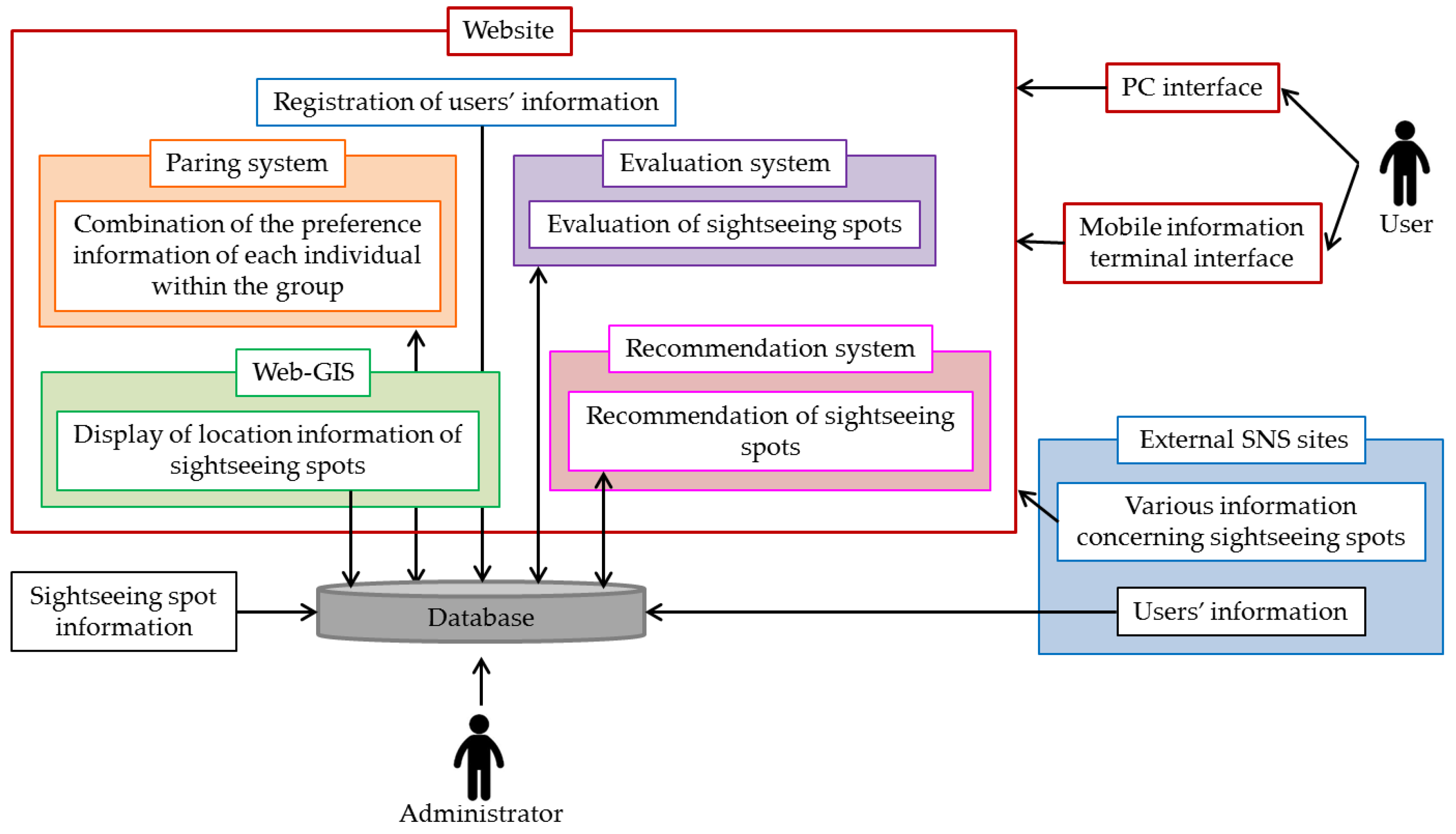
4. System Development
4.1. The Frontend of the System
The system will implement unique functions for users, which will be mentioned below, in response to the aim of the present study, as mentioned in
Section 1. In order to implement these several unique functions, the system was developed by integrating multiple systems into a single system, and it was also connected with external SNS.
(1) Login function connected to external SNS:
Before logging in to the system, by clicking on the “login and sign up” button in the menu bar at the top of the screen or on the link under “your information” in the sidebar on the left of the screen, users can move to the login page. If users click on the Facebook or Twitter icon under “connect to SNS” and allow access to their SNS information, user registration will be complete. Next, by going to the “my page” screen, users can enter their information and preferences.
(2) Group registration function:
After logging in to the system, users can go to the group register page by clicking on “my page” in the menu bar at the top of the screen followed by the “register and edit group” under “menu items of my page. Sightseeing groups can be registered on this page. The membership number that was given to each user is needed when registering a group. After entering the number of other users in the applicable category such as “family”, “partner and spouse”, “friends group 1” and “friends group 2”, users can press “register”.
(3) Viewing function of sightseeing spot information:
After logging in to the system, users can go to the viewing page for sightseeing spot information by clicking on the “view sightseeing spots” in the menu bar.
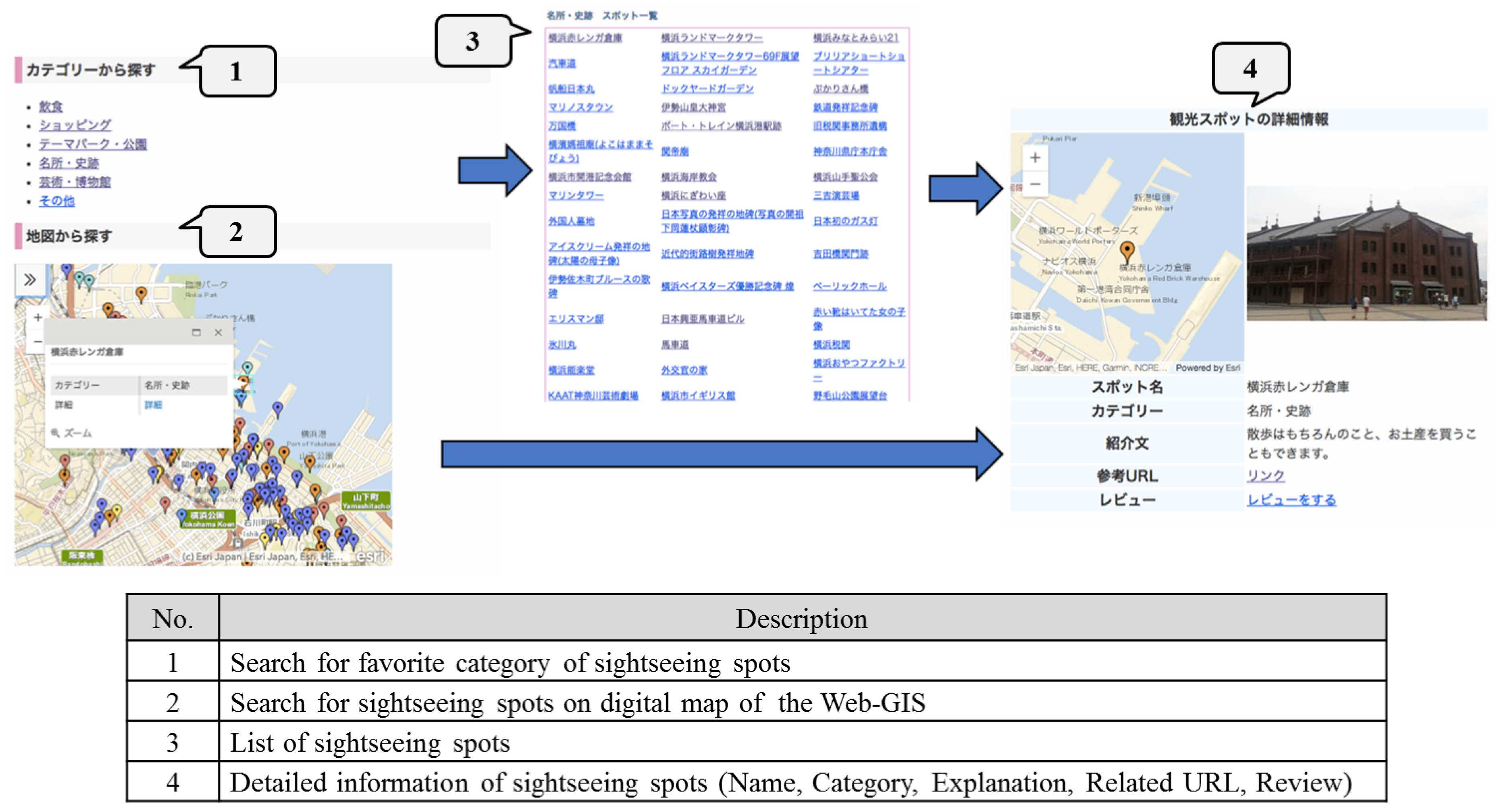
Figure 3 shows the pages for the viewing function of sightseeing spot information. On the sightseeing spot search page shown on the left page of
Figure 3, searches can be made using either “search category” or “search on map”. In case of the former, when users choose a category, a list of sightseeing spots within that category will be displayed shown on the middle page of
Figure 3. If users choose a sightseeing spot name from the list, they can view the details on that sightseeing spot. In the case of the latter, a marker colored differently according to its category will be shown on the digital map of the Web-GIS. By clicking on the icon at the top left of the screen, explanatory notes can be displayed, and users can also choose to display and hide the markers. When the marker is clicked on, as shown on the right page of
Figure 3, a popup containing the “name of the sightseeing spot”, “category” and “details link” will be displayed. By clicking on “details link”, users can view detailed information concerning sightseeing spots.
(4) Evaluation function of sightseeing spots:
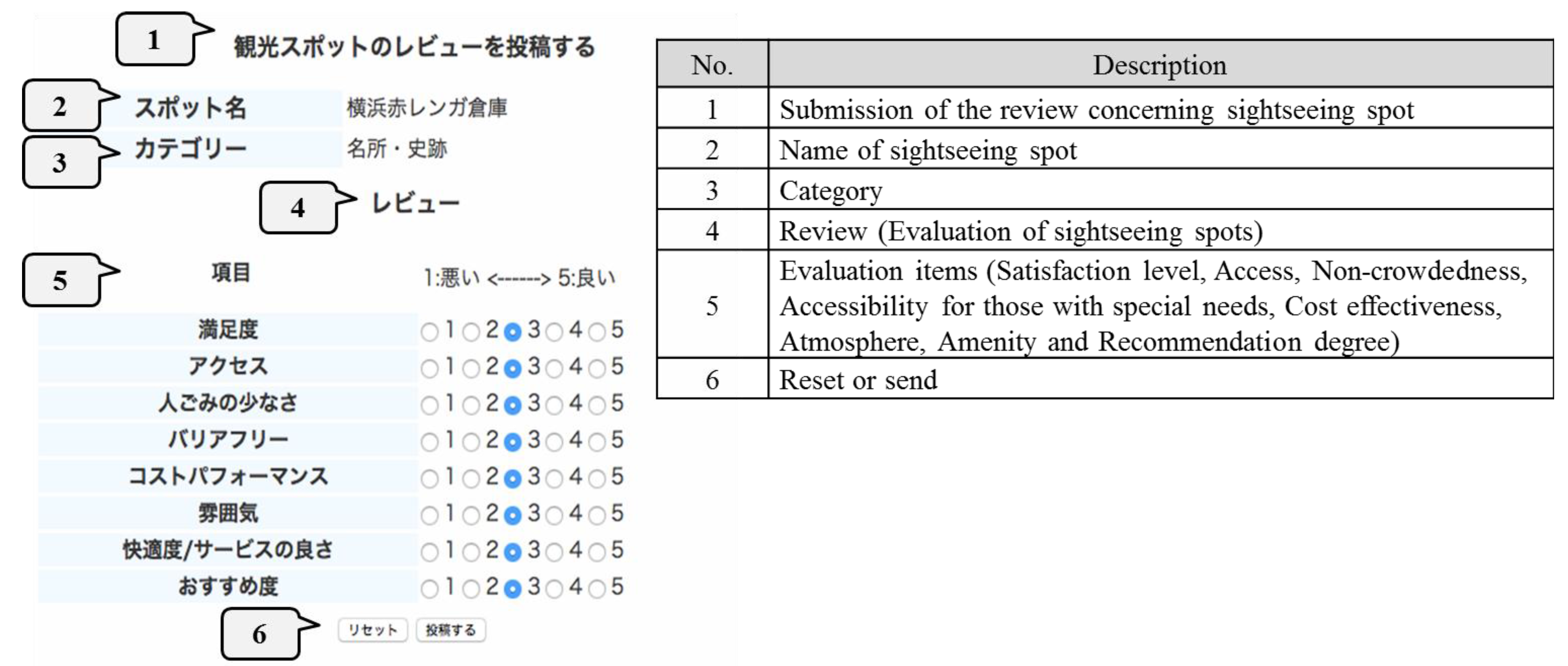
By clicking on “write a review” in the items displayed on the page with details on sightseeing spots, users will be moved to the review page for sightseeing spots.
Figure 4 shows the page for the evaluation function of sightseeing spots. On this page, users can review and evaluate sightseeing spots they have visited. Users will conduct a five-grade evaluation concerning eight evaluation items, and the review will be submitted by clicking on “submission”. The answers are designed not to overlap.
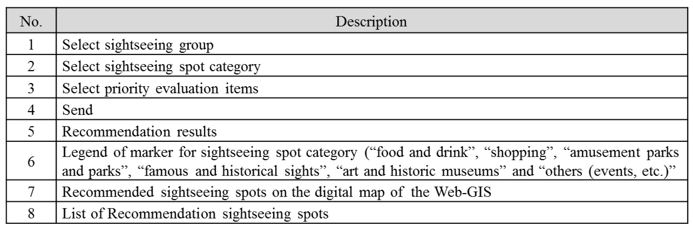
(5) Recommendation function of sightseeing spots:
After logging in to the system, users can go to the sightseeing spot recommendation page by clicking on “sightseeing spot recommendations” in the menu bar.
Figure 5 shows the pages for the recommendation function of sightseeing spots. On the sightseeing spot recommendation page as shown on the right side of
Figure 5, users can select a “sightseeing group” and “sightseeing spot category”, as well as “priority evaluation items”, and click on “send”. Then, on the right page of
Figure 5, the list of recommended sightseeing spots will appear, and the location information will be displayed on the digital map of the Web-GIS. As with the “search on map” of the viewing function of sightseeing spot information, a popup containing the “name of the sightseeing spot”, “category” and “details link” will be displayed when clicking on the markers within the map. Users can go to the detailed information page on sightseeing spots by clicking on “details link” in the popup or the link shown in the list of sightseeing spots. Additionally, on the display screen for recommendation results, the “group”, “category” and “priority evaluation items”, which were selected when using the recommendation function of sightseeing spots, will be displayed on the left side of the screen, while explanatory notes concerning the markers will be displayed on the digital map of the Web-GIS.
4.2. The Backend of the System
(1) Member registration and login processes linked with SNS:
The login function connected to the external SNS was created using the Twitter OAuth library made for developers in the case of Twitter and the “Facebook login” made for Facebook developers in the case of Facebook. Regarding registration of user information and login, the hash value of the internal management parameter, obtained through callback when the user allows access to SNS information, is generated using the hash function of PHP. A search through the database for this value will be conducted, and the login process will start if there is a match. If there is no match, the hash value will be accumulated in the database in order to register the user. Moreover, in the case of Facebook, as “gender” and “age” are contained in the information obtained through callback, these are also accumulated in the database in order to lessen the burden on the users.
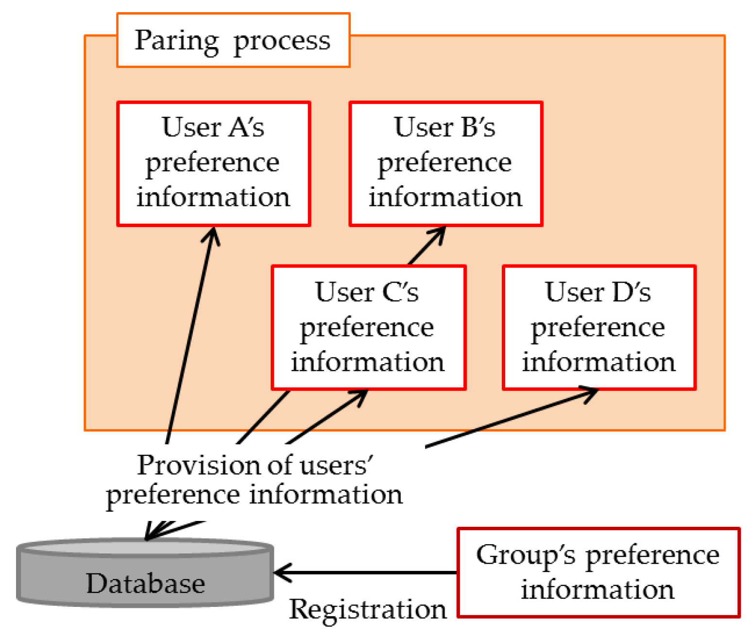
(2) Pairing process between users:
In the preceding studies introduced in
Section 2, users can receive sightseeing spot recommendations that meet individual preferences from the system by registering their own preferences. However, in the system, sightseeing activities for individuals, as well as groups are supported. Therefore, in the system, by combining the preferences of all users within a group registered at the frontend, the process of calculating the group preference will be conducted at the backend. The conceptual diagram concerning this process is as shown in
Figure 6.
When a user registers a group (connecting users), the preference information of connected users is taken from the user information accumulated in the database, and the group preference is calculated by combining the information according to the process described in
Section 3.4.2. By accumulating this in the database, recommendations for when a group is registered can be received.
(3) Process concerning the evaluation function of sightseeing spots:
In order to make the recommended sightseeing spots in the system closer to the preferences of a user, the system has users write a review on sightseeing spots they have visited, and a calculation process of this new evaluation value is conducted at the system backend. Evaluation values from the sightseeing spot data, which are accumulated in the database, are imported, and using this, as well as the evaluation values obtained from user reviews, new evaluation values are calculated and the values in the database updated.
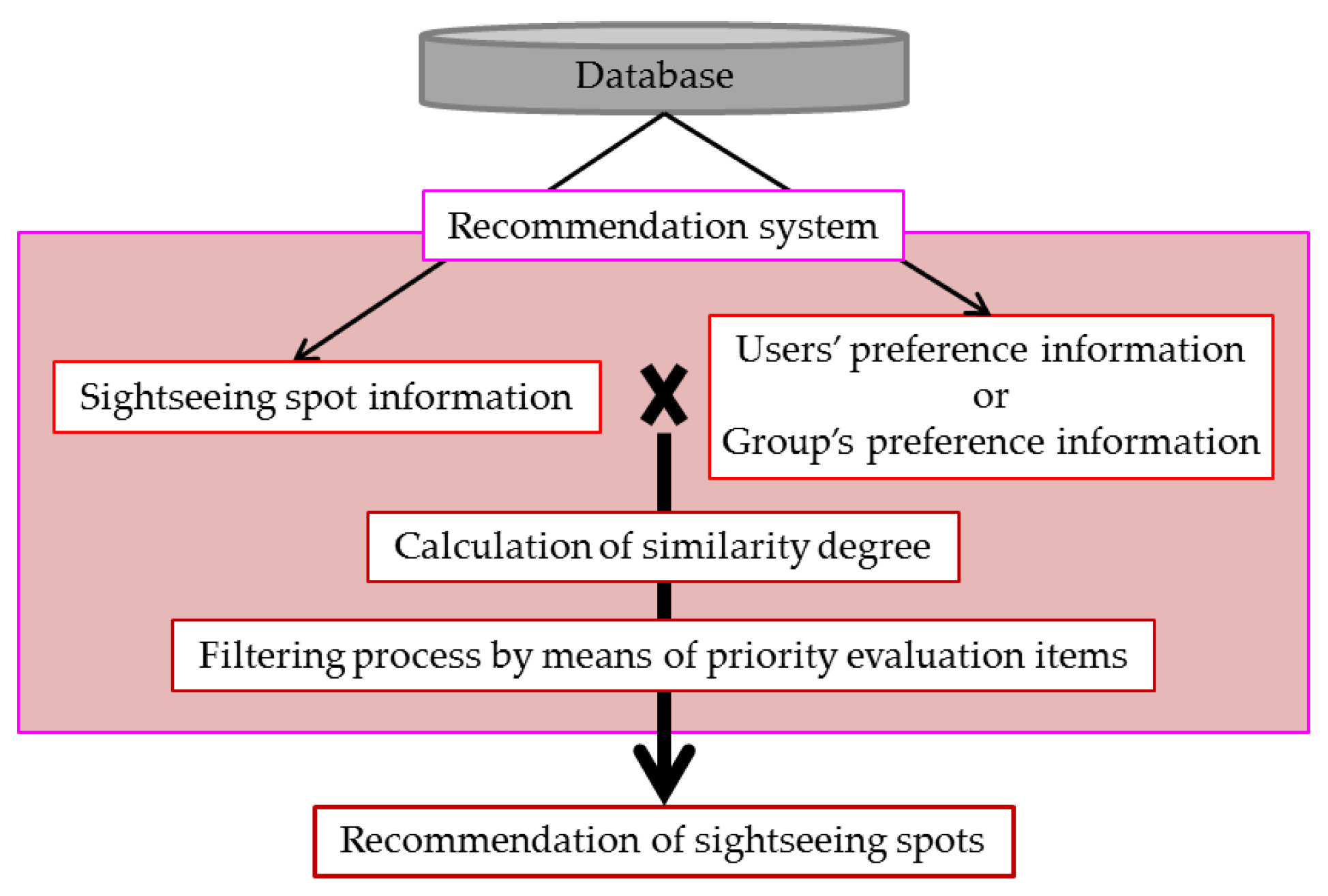
(4) Process concerning the recommendation system:
The calculation process of the degree of similarity used when recommending sightseeing spots to users and the filtering process by means of priority evaluation items set by users are conducted at the backend. By having users register their preferences and select priority evaluation items when choosing recommendation conditions, users are able to receive recommendations. The conceptual diagram concerning this process is shown in
Figure 7. Regarding the evaluation information of sightseeing spots and user preferences (or group preferences) accumulated in the database, the degree of similarity will be calculated using Equation (8) shown in
Section 3.4.3. Furthermore, the sightseeing spot information and evaluation values of the top 20 in similarity will be selected, sorted (filtered) according to the value of priority evaluation items, and the top 10 sightseeing spots will be displayed as recommendation results.
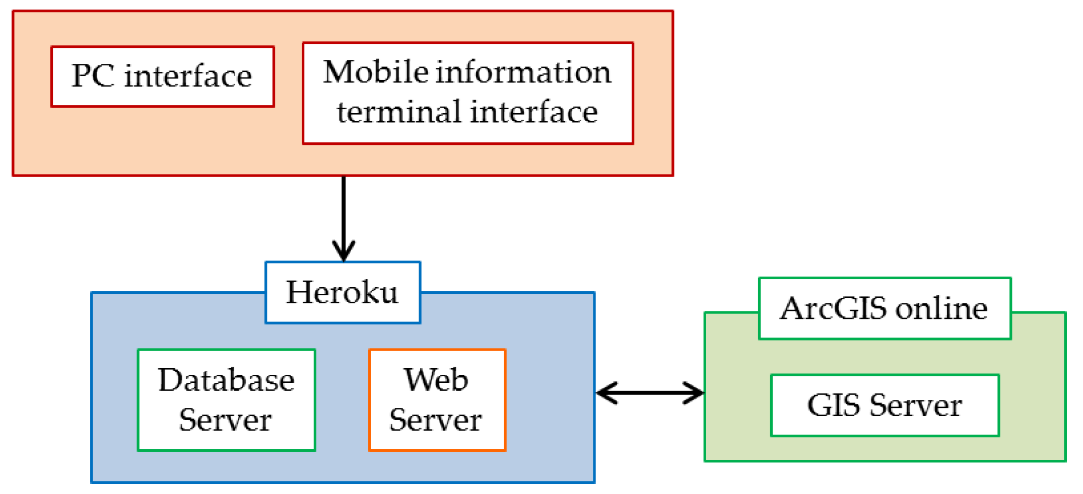
4.3. System Interface
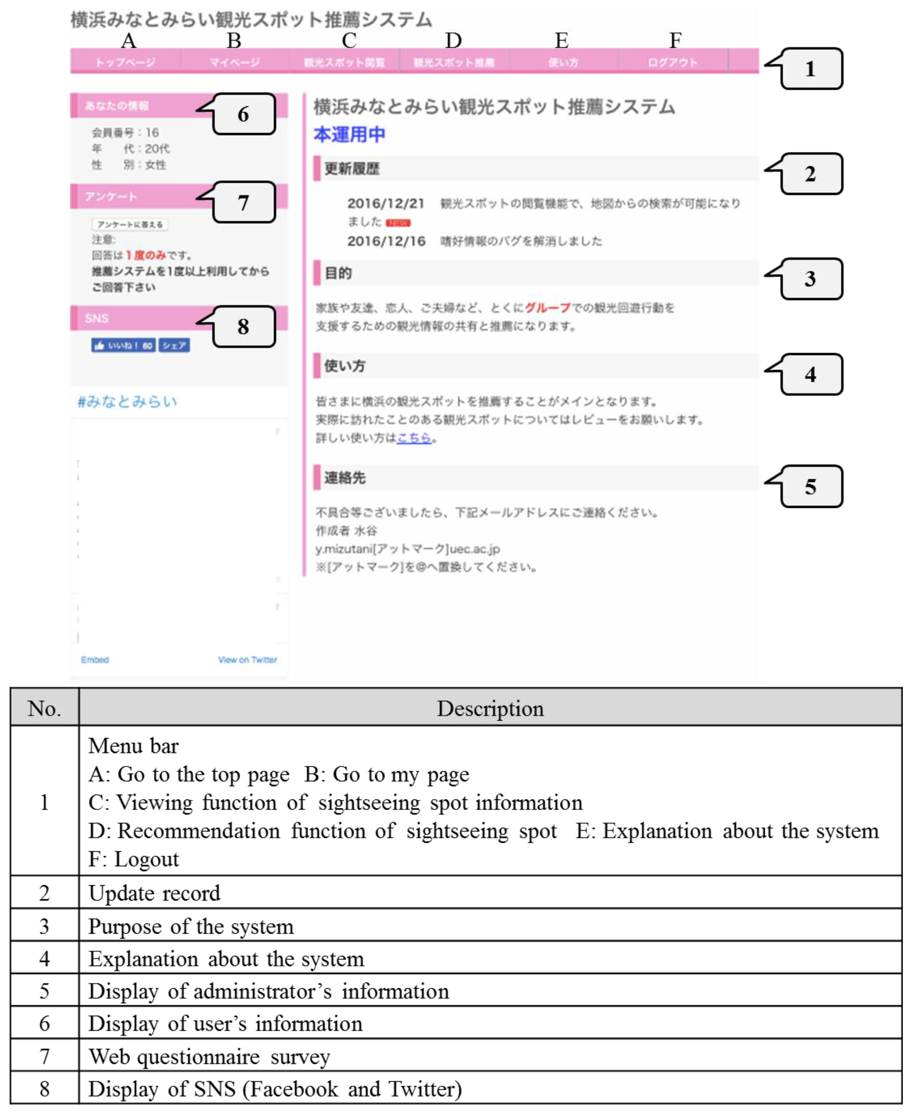
The system has two types of interfaces: the PC screen and mobile device screen for users (
Figure 8), and the PC screen for the administrator. In the latter, the “membership number”, “ID”, “age” and “gender” of all users can be checked from a list. Furthermore, regarding users that have registered using the SNS link, the ID item will list either “Facebook” or “Twitter”. Additionally, due to the simplification of user management using GUI (Graphic User Interface), procedures such as the deletion of unauthorized users can be done without depending on the IT literacy of the administrator.
6. Evaluation
After the end of the operation, a web questionnaire survey and access analysis of users’ log data were conducted in order to evaluate the system developed in the present study.
6.1. Evaluation Based on Web Questionnaire Survey
6.1.1. Overview of the Web Questionnaire Survey
Along with the purpose of the present study, a web questionnaire survey was implemented in order to conduct an (1) evaluation concerning the use of the system and an (2) evaluation concerning the functions of the system. The web questionnaire survey was conducted for one week after the start of the operation.
Table 1 also shows an overview of the web questionnaire survey. As shown in
Table 1, 32 out of 52 users submitted their web questionnaire survey, and the valid response rate was 62%.
6.1.2. Evaluation Concerning the Use of the System
(1) Evaluation of suitability with the information acquisition method for sightseeing spots:
Regarding information acquisition methods for sightseeing spots (multiple answers allowed), 72% were PCs, 44% were mobile devices, 47% were guidebooks and 16% were others (pamphlets and flyers). Therefore, it was made evident that many users obtain sightseeing information from the Internet using PCs and mobile devices in addition to using printed mediums such as guidebooks. This also made it clear that the system, which obtains sightseeing spot information using PCs and mobile devices, is effective.
(2) Evaluation focusing on the utilization state of the system:
Regarding the devices used by users for the system, 72% were PCs, 25% were smartphones and 3% were tablets. Therefore, it was made evident that the system was mainly used on PCs. The number of users who used external SNS login remained at 31%. This is because the login function connected to external SNS can only be used by SNS users.
6.1.3. Evaluation Concerning the Functions of the System
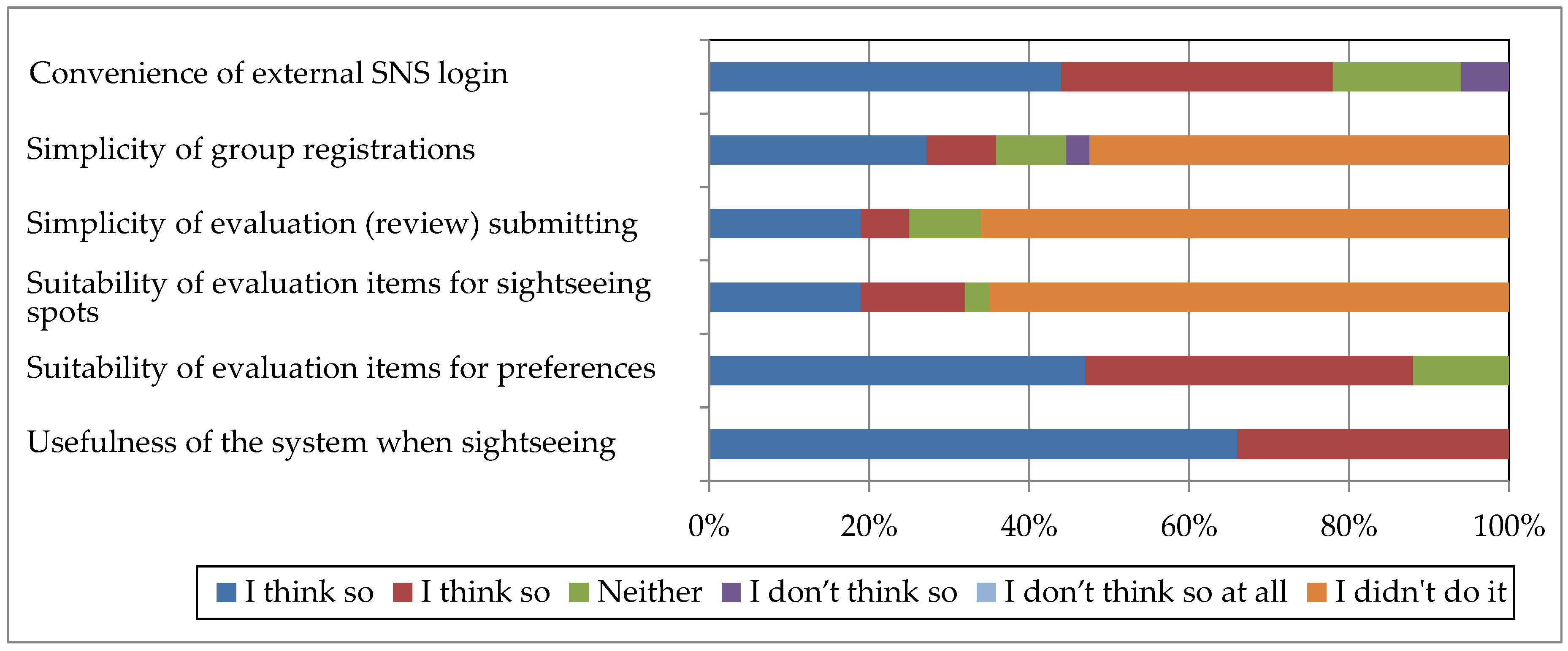
(1) Evaluations for each function, as well as the whole system:
The evaluation results for each function, excluding the recommendation function of sightseeing spots, and the entire system are shown in
Figure 9. Regarding the convenience of external SNS login, 78% answered “I think so” or “I somewhat think so”, 16% answered “neither” and 6% answered “I don’t think so”. Therefore, as previously pointed out, because the login function connected to external SNS can only be used by SNS users, it can be said that those who are not SNS users do not recognize its convenience. Regarding the simplicity of group registrations, though 54% did not answer, 37% answered “I think so” or “I somewhat think so”, 9% answered “neither” and 3% answered “I don’t think so”. Therefore, though the group registration function is not so often used, those who used the function think it to be easy to use.
Regarding the simplicity of evaluation (review) submitting, though 66% did not answer, 25% answered “I think so” or “I somewhat think so” and 9% answered “neither”. For the suitability of evaluation items for sightseeing spots, though 66% did not answer, 32% answered “I think so” or “I somewhat think so” and 3% answered “neither”. Therefore, though the evaluation function of sightseeing spot is not often used, it can be said that the function is easy to use for those who have used it and that the evaluation items set in advance are suitable. Regarding the suitability of evaluation items for preferences, as 88% answered “I think so” or “I somewhat think so”, it can be said that the evaluation items set in advance were suitable.
Regarding the usefulness of the system when sightseeing, all users answered “I think so” or “I somewhat think so”. Because the system is highly useful when sightseeing as indicated by the results above, it can be expected that users will more fully use each function by continuously operating the system. Additionally, the group registration function and evaluation function of sightseeing spots in the system were hardly used during the operation period. Because the system was operated just for four weeks and the user did not fully utilize these two functions during the short operation period, these functions may be used more often by the continuous operation of the system, and this may advance the usefulness of the system when sightseeing.
(2) Detailed evaluations for the recommendation function of sightseeing spots:
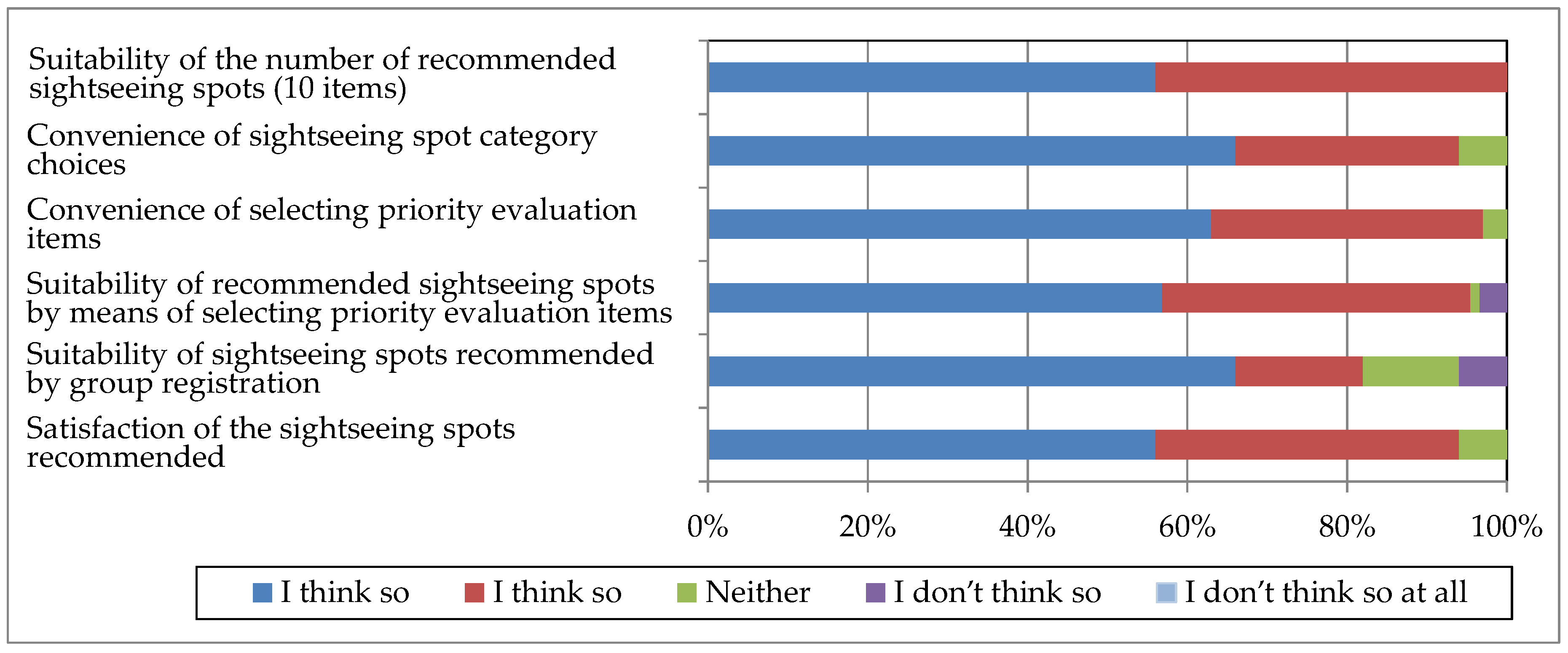
Evaluation results for the recommendation function of sightseeing spots, which is the system’s original function, are shown in
Figure 10. For the suitability of the number of recommended sightseeing spots (10 items), as all users answered “I think so” or “I somewhat think so”, it was made evident that recommending multiple sightseeing spots was suitable. Regarding the convenience of sightseeing spot category choices, a high percentage of 94% answered “I think so” or “I somewhat think so”, so it can be said that the category selection when getting a recommendation was effective.
For the convenience of selecting priority evaluation items, the results were good with 97% answering “I think so” or “I somewhat think so”. Additionally, regarding the suitability of recommended sightseeing spots by means of selecting priority evaluation items, 84% answered “I think so” or “I somewhat think so”. From these results, it can be said that the selection of evaluation items to prioritize when the system makes a recommendation was effective.
Regarding the suitability of sightseeing spots recommended by group registration, the evaluation was somewhat lower than other questions with a result of 82% answering “I think so” or ”I somewhat think so”. As previously mentioned, the group registration function was hardly used during the operation period. However, if the group registration is more often used by the continuous operation of the system, this may improve the suitability of sightseeing spots recommended to groups. Additionally, for the satisfaction of the sightseeing spots recommended, the results were very high with 94% answering “I think so” or “I somewhat think so”. Therefore, the method of the system, in which the preferences of all users within the group are reflected in the recommended sightseeing spots, can be considered to be highly effective.
6.2. Evaluation Based on Access Analysis
In the present study, an access analysis was conducted using the users’ log data during the operation period. This analysis was conducted using Google Analytics, which is a web access analysis service provided by Google. A PHP program with the analysis code made using Google Analytics was created, and for the target websites for the access analysis, the access log was obtained by scanning the PHP program made for the access analysis of the program in each page within that website.
The access method to the system is shown in
Table 2. There is hardly any difference in the use of PCs and mobile devices as an access method. This is because smartphones are now often used as an easy way to obtain information. Therefore, the system design, which was made to eliminate the differences in obtainable information depending on the type of device and to make the system available to all types of devices, can be considered effective.
The top 10 number of page visits is shown in
Table 3. As it is made clear in
Table 3, except for the top page and how to use page, the sightseeing spot recommendation page has the most visits, and it is also evident that the system is being used according to the purpose of the present study, which is to support the sightseeing activities of users. However, as few users viewed the group registration page, it cannot be said that the system was used to the fullest extent. This may be because the operation period was limited and only a few actually used the system as a group. Additionally, the user information edit page also had a low number of visits. Therefore, it is evident that the preferences of users hardly changed in a short period of time, and most users did not change their preference registration after the initial registration. However, by conducting a long-term operation of the system, it is expected that the preferences of users will change and more users will change their preference information through the user information edit page.
6.3. Extraction of Improvement Measures
The issues concerning the system were extracted based on the results of the web questionnaire survey, as well as the access analysis of users’ log data, and they are summarized below.
(1) Adding and updating of sightseeing spot information by users:
Though the system had prepared sightseeing spot information in advance, in order to operate on a long-term basis, the sightseeing spot information should be updated when necessary. Therefore, a function where users can add and update information is needed.
(2) Implementing a routing function:
In the system, sightseeing spots that meet the preferences of both individual users and groups can be recommended. However, the system only recommends sightseeing spots and provides detailed information. Therefore, in order to effectively support the sightseeing activities of users, it is necessary to implement a routing function from major stations and current locations to destinations.
(3) Improving the group registration function:
In the system, users can register groups. However, during the operation period, only half of those who answered the web questionnaire survey had used this group registration function. Therefore, it is necessary to make the group registration easier to use.


