
Fractal Characterization of Settlement Patterns and Their Spatial Determinants in Coastal Zones

Abstract
:1. Introduction
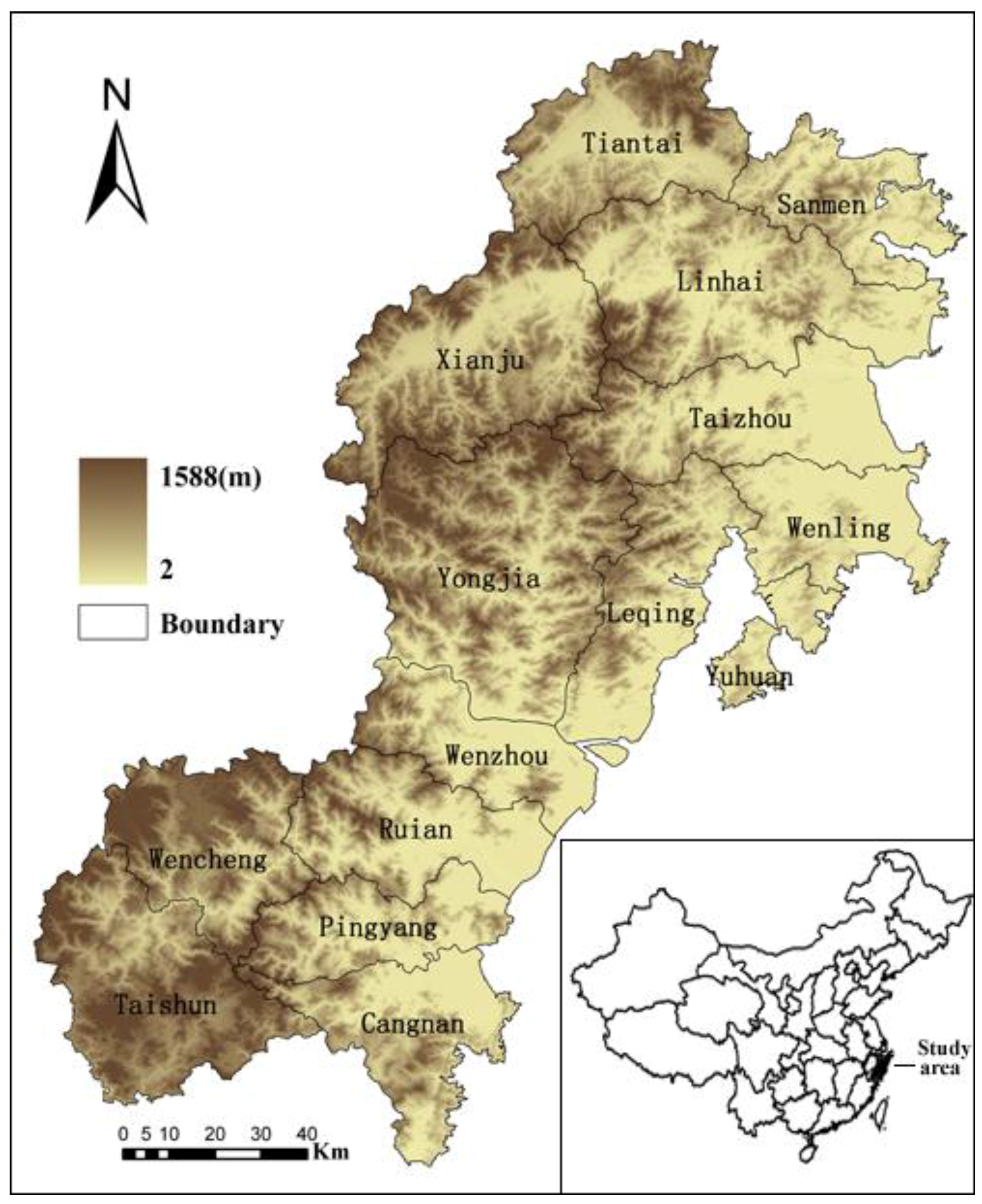
2. Study Area

3. Materials and Method
3.1. Fractal Dimension
3.1.1. Fractal and Fractal Dimension
3.1.2. Box-Counting Dimension
3.2. GIS Analysis

3.3. Spatial Regression
4. Results and discussion
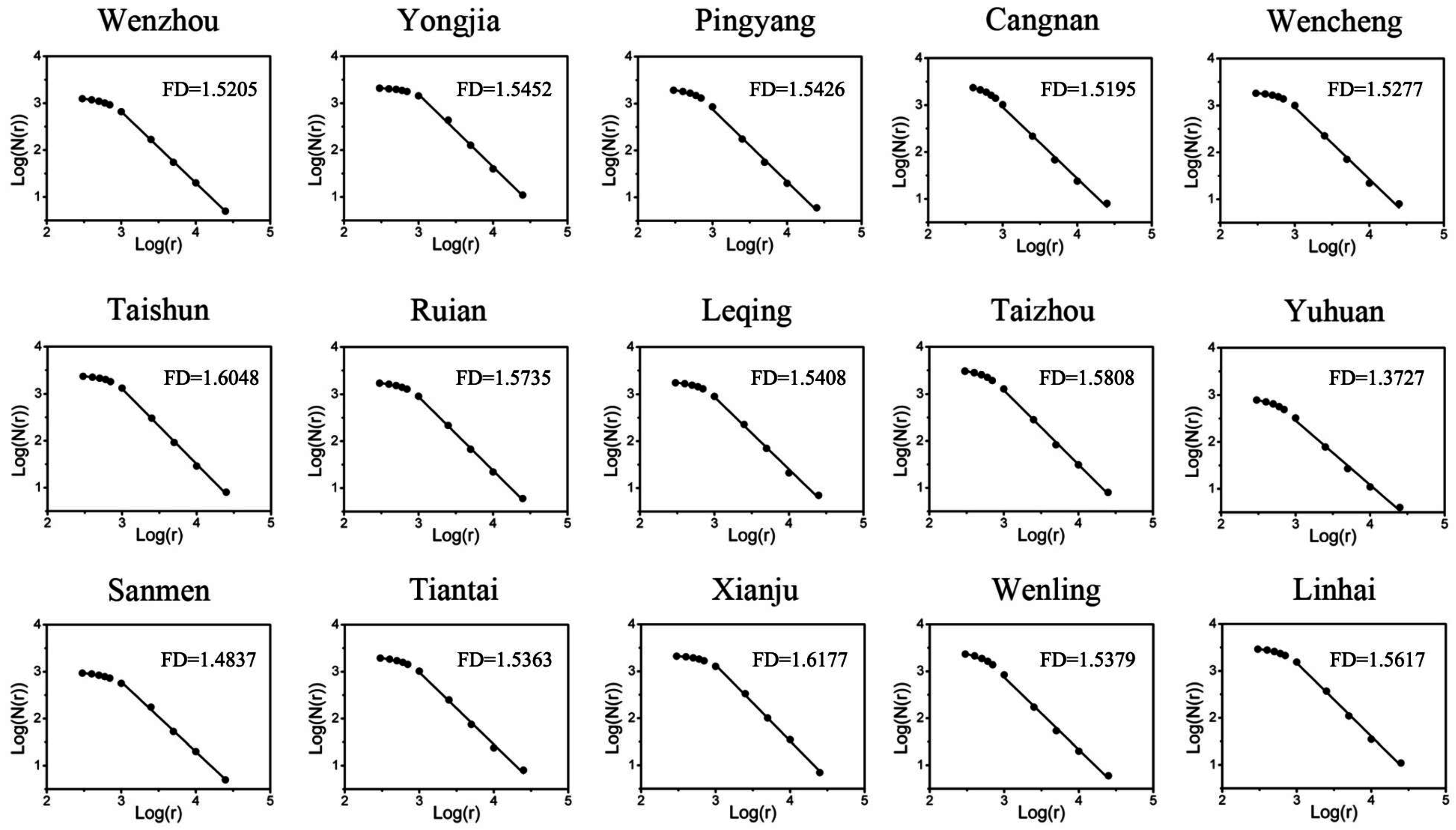
4.1. Fractal Dimension of Human Settlement Patterns

| Study Area | N | DB | R2 | Crossover Point (m) |
|---|---|---|---|---|
| Wenzhou | 1330 | 1.5205 | 0.9998 | 995.7264 |
| Yongjia | 2152 | 1.5452 | 0.9975 | 1081.909 |
| Pingyang | 2096 | 1.5426 | 0.9964 | 665.9738 |
| Cangnan | 2709 | 1.5195 | 0.9945 | 535.1751 |
| Wencheng | 1925 | 1.5277 | 0.9936 | 841.997 |
| Taishun | 2433 | 1.6048 | 0.9986 | 950.6467 |
| Ruian | 1805 | 1.5735 | 0.9991 | 940.769 |
| Leqing | 1917 | 1.5408 | 0.9961 | 924.269 |
| Taizhou | 3568 | 1.5808 | 0.9982 | 845.5723 |
| Yuhuan | 905 | 1.3727 | 0.9938 | 526.7021 |
| Sanmen | 1050 | 1.4837 | 0.9984 | 995.5408 |
| Tiantai | 2217 | 1.5363 | 0.9958 | 897.9551 |
| Xianju | 2243 | 1.6177 | 0.9989 | 1020.453 |
| Wenling | 2689 | 1.5379 | 0.9957 | 433.6554 |
| Linhai | 3371 | 1.5617 | 0.9968 | 925.4678 |
4.2. Spatial Determinants of Settlement Fractal Dimensions
| Y | X | Model | R2 | Sig |
|---|---|---|---|---|
| Fractal dimension | elevation_mean | NSc | ||
| elevation_std | Y b = 0.0007 × X + 1.42 (LAMBDA = −0.33) | 0.52 | ** | |
| slope_mean | NSc | |||
| slope_std | Y a = −0.95 × WY + 0.055 × X + 2.74 | 0.63 | ** | |
| road_mean | NSc | |||
| road_std | NSc | |||
| river_mean | NSc | |||
| river_std | NSc | |||
| sand% | NSc | |||
| loam% | Y a = 0.07 × WY + 0.22 × X + 1.44 | 0.56 | ** | |
| clay-loam% | NSc | |||
| clay% | NSc | |||
4.3. Management Implications
5. Conclusions
- Settlement patterns in the Wen-Tai region presented significant fractal characteristics and exhibited obvious spatial variations. The pattern of settlements, rather than the number of settlements, was more influential factor for the fractal dimension.
- Elevation, slope, and percentage of loam soils were the primary spatial determinants of settlement fractal dimensions. Especially, cities with greater relief amplitude and higher slope variability always exhibit more complex form, and cities with a higher percentage of loam soils have more complicated patterns.
- Proximity to road or river were insignificant indicators for the morphological characteristics of settlement patterns.
- Settlement fractal dimensions not only depended on slope and soil texture, but also on settlement fractal dimensions of neighboring cities.
Acknowledgements
Author Contributions
Conflicts of Interest
References
- Carrion-Flores, C.; Irwin, E.G. Determinants of residential land-use conversion and sprawl at the rural-urban fringe. Am. J. Agric. Econ. 2004, 86, 889–904. [Google Scholar] [CrossRef]
- Choguill, C.L. The search for policies to support sustainable housing. Habitat Int. 2007, 31, 143–149. [Google Scholar] [CrossRef]
- Goebel, A. Sustainable urban development? Low-cost housing challenges in South Africa. Habitat Int. 2007, 31, 291–302. [Google Scholar] [CrossRef]
- Su, S.; Jiang, Z.; Zhang, Q.; Zhang, Y. Transformation of agricultural landscapes under rapid urbanization: A threat to sustainability in Hang-Jia-Hu region, China. Appl. Geogr. 2011, 31, 439–449. [Google Scholar] [CrossRef]
- Small, C.; Gornitz, V.; Cohen, J.E. Coastal hazards and the global distribution of human population. Environ. Geosci. 2000, 7, 3–12. [Google Scholar] [CrossRef]
- Mubareka, S.; Ehrlich, D.; Bonn, F.; Kayitakire, F. Settlement location and population density estimation in rugged terrain using information derived from Landsat ETM and SRTM data. Int. J. Remote Sens. 2008, 29, 2339–2357. [Google Scholar] [CrossRef]
- Fan, F.; Wang, Y.; Qiu, M.; Wang, Z. Evaluating the temporal and spatial urban expansion patterns of Guangzhou from 1979 to 2003 by remote sensing and GIS methods. Int. J. Geogr. Inf. Sci. 2009, 23, 1371–1388. [Google Scholar] [CrossRef]
- Liu, J.; Zhan, J.; Deng, X. Spatio-temporal patterns and driving forces of urban land expansion in China during the economic reform era. AMBIO: J. Hum. Environ. 2005, 34, 450–455. [Google Scholar] [CrossRef]
- Shen, G. Fractal dimension and fractal growth of urbanized areas. Int. J. Geogr. Inf. Sci. 2002, 16, 419–437. [Google Scholar] [CrossRef]
- Webster, C. Urban morphological fingerprints. Environ. Plan. B: Plan. Des. 1996, 23, 279–297. [Google Scholar] [CrossRef]
- Dewan, A.M.; Yamaguchi, Y. Land use and land cover change in Greater Dhaka, Bangladesh: Using remote sensing to promote sustainable urbanization. Appl. Geogr. 2009, 29, 390–401. [Google Scholar] [CrossRef]
- Dewan, A.M.; Yamaguchi, Y. Using remote sensing and GIS to detect and monitor land use and land cover change in Dhaka Metropolitan of Bangladesh during 1960–2005. Environ. Monit. Assess. 2009, 150, 237–249. [Google Scholar] [CrossRef] [PubMed]
- Schweitzer, F.; Steinbrink, J. Estimation of megacity growth: Simple rules versus complex phenomena. Appl. Geogr. 1998, 18, 69–81. [Google Scholar] [CrossRef]
- Schwimmer, R.A. A temporal geometric analysis of eroding marsh shorelines: Can fractal dimensions be related to process? J. Coast. Res. 2008, 152–158. [Google Scholar] [CrossRef]
- Camagni, R.; Gibelli, M.C.; Rigamonti, P. Urban mobility and urban form: The social and environmental costs of different patterns of urban expansion. Ecol. Econ. 2002, 40, 199–216. [Google Scholar] [CrossRef]
- De Keersmaecker, M.-L.; Frankhauser, P.; Thomas, I. Using fractal dimensions for characterizing intra-urban diversity: The example of Brussels. Geogr. Anal. 2003, 35, 310–328. [Google Scholar] [CrossRef]
- Pérez-Rodríguez, L.; Jovani, R.; Mougeot, F. Fractal geometry of a complex plumage trait reveals bird’s quality. Proc. R. Soc. Lond. B: Biol. Sci. 2013, 280, 20122783. [Google Scholar] [CrossRef] [PubMed] [Green Version]
- Li, B.-L. Fractal geometry applications in description and analysis of patch patterns and patch dynamics. Ecol. Model. 2000, 132, 33–50. [Google Scholar] [CrossRef]
- Kruhl, J.H. Fractal-geometry techniques in the quantification of complex rock structures: A special view on scaling regimes, inhomogeneity and anisotropy. J. Struct. Geol. 2013, 46, 2–21. [Google Scholar] [CrossRef]
- Jiang, Z.; Wang, H.; Fei, B. Research into the application of fractal geometry in characterising machined surfaces. Int. J. Mach. Tool. Manuf. 2001, 41, 2179–2185. [Google Scholar] [CrossRef]
- Terzi, F.; Kaya, H.S. Dynamic spatial analysis of urban sprawl through fractal geometry: The case of Istanbul. Environ. Plan.-Part B 2011, 38, 175. [Google Scholar] [CrossRef]
- Chen, Y. Fractal dimension evolution and spatial replacement dynamics of urban growth. Chaos Solitons Fract. 2012, 45, 115–124. [Google Scholar] [CrossRef]
- Dewan, A.M.; Yamaguchi, Y.; Rahman, M.Z. Dynamics of land use/cover changes and the analysis of landscape fragmentation in Dhaka Metropolitan, Bangladesh. GeoJournal 2012, 77, 315–330. [Google Scholar] [CrossRef]
- Tannier, C.; Thomas, I. Defining and characterizing urban boundaries: A fractal analysis of theoretical cities and Belgian cities. Comput. Environ. Urban Syst. 2013, 41, 234–248. [Google Scholar] [CrossRef]
- Feng, Y.; Liu, Y. Fractal dimension as an indicator for quantifying the effects of changing spatial scales on landscape metrics. Ecol. Indic. 2015, 53, 18–27. [Google Scholar] [CrossRef]
- Thomas, I.; Frankhauser, P.; Biernacki, C. The morphology of built-up landscapes in Wallonia (Belgium): A classification using fractal indices. Landsc. Urban Plan. 2008, 84, 99–115. [Google Scholar] [CrossRef]
- Byomkesh, T.; Nakagoshi, N.; Dewan, A.M. Urbanization and green space dynamics in Greater Dhaka, Bangladesh. Landsc. Ecol. Eng. 2012, 8, 45–58. [Google Scholar] [CrossRef]
- Lu, Y.; Tang, J. Fractal dimension of a transportation network and its relationship with urban growth: A study of the Dallas-Fort Worth area. Environ. Plan. B. 2004, 31, 895–912. [Google Scholar] [CrossRef]
- Bureau, Z.S. Zhejiang Statistical Yearbook; China Statistics Press: Beijing, China, 2004. (In Chinese) [Google Scholar]
- Long, H.; Zou, J.; Pykett, J.; Li, Y. Analysis of rural transformation development in China since the turn of the new millennium. Appl. Geogr. 2011, 31, 1094–1105. [Google Scholar] [CrossRef]
- Mandelbrot, B.B. The Fractal Geometry of Nature/Revised and Enlarged Edition; WH Freeman Co.: New York, NY, USA, 1983. [Google Scholar]
- Emerson, C.W.; Lam, N.S.N.; Quattrochi, D.A. A comparison of local variance, fractal dimension, and Moran’s I as aids to multispectral image classification. Int. J. Remote Sens. 2005, 26, 1575–1588. [Google Scholar] [CrossRef]
- Peitgen, H.-O.; Jürgens, H.; Saupe, D. Chaos and Fractals: New Frontiers of Science; Springer Sci. & Business Media: New York, NY, USA, 2006. [Google Scholar]
- Carlson, C.A. Spatial distribution of ore deposits. Geology 1991, 19, 111–114. [Google Scholar] [CrossRef]
- Ford, A.; Blenkinsop, T.G. Combining fractal analysis of mineral deposit clustering with weights of evidence to evaluate patterns of mineralization: Application to copper deposits of the Mount Isa Inlier, NW Queensland, Australia. Ore Geol. Rev. 2008, 33, 435–450. [Google Scholar] [CrossRef]
- Gillespie, P.; Howard, C.; Walsh, J.; Watterson, J. Measurement and characterisation of spatial distributions of fractures. Tectonophysics 1993, 226, 113–141. [Google Scholar] [CrossRef]
- Walsh, J.; Watterson, J. Fractal analysis of fracture patterns using the standard box-counting technique: Valid and invalid methodologies. J. Struct. Geol. 1993, 15, 1509–1512. [Google Scholar] [CrossRef]
- Raines, G.L. Are fractal dimensions of the spatial distribution of mineral deposits meaningful? In Progress in Geomathematics; Springer: Berlin, Germany, 2008; pp. 285–301. [Google Scholar]
- Gude, P.H.; Hansen, A.J.; Rasker, R.; Maxwell, B. Rates and drivers of rural residential development in the Greater Yellowstone. Lands. Urban Plan. 2006, 77, 131–151. [Google Scholar] [CrossRef]
- Gonzalez-Abraham, C.E.; Radeloff, V.C.; Hammer, R.B.; Hawbaker, T.J.; Stewart, S.I.; Clayton, M.K. Building patterns and landscape fragmentation in northern Wisconsin, USA. Lands. Ecol. 2007, 22, 217–230. [Google Scholar] [CrossRef]
- Anselin, L. Local indicators of spatial association-LISA. Geogr. Anal. 1995, 27, 93–115. [Google Scholar] [CrossRef]
- Anselin, L. Exploring spatial Data with GeoDaTM: A Workbook; University of Illinois: Urbana, IL, USA, 2008. [Google Scholar]
- Cai, B.; Zhang, Z.; Liu, B.; Zhou, Q. Spatial-temporal changes of Tianjin urban spatial morphology from 1978 to 2004. J. Geogr. Sci. 2007, 17, 500–510. [Google Scholar] [CrossRef]
- Barnsley, M.F. Fractals Everywhere; Academic Press: Cambridge, MA, USA, 2014. [Google Scholar]
- Lacombe, D.J.; Shaughnessy, T.M. Accounting for spatial error correlation in the 2004 presidential popular vote. Public Financ. Rev. 2007, 35, 480–499. [Google Scholar] [CrossRef]
- Su, S.; Zhang, Q.; Zhang, Z.; Zhi, J.; Wu, J. Rural settlement expansion and paddy soil loss across an ex-urbanizing watershed in eastern coastal China during market transition. Reg. Environ. Change 2011, 11, 651–662. [Google Scholar] [CrossRef]
- Newton, A.; Weichselgartner, J. Hotspots of coastal vulnerability: A DPSIR analysis to find societal pathways and responses. Estuar. Coast. Shelf Sci. 2014, 140, 123–133. [Google Scholar] [CrossRef]
- Douglas, I. Peri-urban ecosystems and societies transitional zones and contrasting values. In Peri-Urban Interface Approaches to Sustainable Natural and Human Resource Use; EARTHSCAN: London, US; New York, NY, USA, 2006; pp. 18–29. [Google Scholar]
- Burak, S.A.; Dogan, E.; Gazioglu, C. Impact of urbanization and tourism on coastal environment. Ocean Coast. Manag. 2004, 47, 515–527. [Google Scholar] [CrossRef]
- Huang, S.-L.; Wang, S.-H.; Budd, W.W. Sprawl in Taipei’s peri-urban zone: Responses to spatial planning and implications for adapting global environmental change. Lands. Urban Plan. 2009, 90, 20–32. [Google Scholar] [CrossRef]
© 2015 by the authors; licensee MDPI, Basel, Switzerland. This article is an open access article distributed under the terms and conditions of the Creative Commons Attribution license (http://creativecommons.org/licenses/by/4.0/).
Share and Cite
Zhang, Z.; Yang, X.; Xiao, R. Fractal Characterization of Settlement Patterns and Their Spatial Determinants in Coastal Zones. ISPRS Int. J. Geo-Inf. 2015, 4, 2728-2741. https://doi.org/10.3390/ijgi4042728
Zhang Z, Yang X, Xiao R. Fractal Characterization of Settlement Patterns and Their Spatial Determinants in Coastal Zones. ISPRS International Journal of Geo-Information. 2015; 4(4):2728-2741. https://doi.org/10.3390/ijgi4042728
Chicago/Turabian StyleZhang, Zhonghao, Xiaoqin Yang, and Rui Xiao. 2015. "Fractal Characterization of Settlement Patterns and Their Spatial Determinants in Coastal Zones" ISPRS International Journal of Geo-Information 4, no. 4: 2728-2741. https://doi.org/10.3390/ijgi4042728