1. Introduction
The geospatial Web 2.0, or Geoweb for short, is a collection of online location-enabled services and infrastructure that is engaging a wide range of stakeholders in mapping processes. The interactions between individuals and groups and the Geoweb environment is, in some instances, generating volunteered geographic information (VGI). Simply defined, “VGI is crowdsourced geographic information provided by a wide range of participants with varying levels of education, knowledge, and skills” [
1]. This type of geographic information, or geo-information, derived from the public through active or passive mechanisms is part of the larger phenomenon of user generated or crowdsourced content [
2], and is producing novel, and often valuable, sources of geo-information [
3,
4]. In the context of the general trend of declining resources for national mapping agencies and the elimination of the Statistics Canada long-form census [
5], VGI is becoming especially important where authoritative geographic information is lacking [
1].
Adding to the value of a novel source of geographic information, there is mounting evidence that institutions—including government and non-government organizations (NGOs)—can use VGI as a mechanism to build local capacity to support collaboration, supplement traditional data sources, and inform decision-making. Johnson and Sieber [
6,
7], for example, explored both the motivation driving government adoption of the Geoweb, and strategies for increasing access to and use of the data subsequently produced. Haklay
et al. [
1] studied VGI use in government, providing the most comprehensive guide for VGI implementation to date. Haklay
et al. [
1] further noted that the process by which the data are collected—including organizational practices, regulatory issues (
i.e., licence conditions), and technical specifications—is more likely to impede the acceptance of VGI than the early concerns associated with quality, accuracy, and completeness of VGI. This raises the question: what are the organizational practices, regulatory issues, and technical specifications that support the production of VGI? Essentially, what systems support the creation of VGI?
Recent literature has alluded to the fact that there needs to be a formal, standardized framework for the creation of VGI for various reasons, which include increasing the completeness, accuracy, and reliability of the VGI produced. For example, Goodchild and Li [
4] highlighted that “the rules in use have been assembled pragmatically and without a conceptual or theoretical framework,” suggesting that a framework can help formalize the VGI process and make it “amenable to implementation.” Peng and Tsou [
8] also encouraged Internet GIS users to understand the mechanisms of system implementation before applying web-based GIS to the range of geographic problems. Finally, Goodchild stated, in a conversation with Turner, “I think the binary between local and professional knowledges is becoming problematic. We need to study the systems that have been used in some VGI projects to measure trust, rather than relying on simple surrogates like professional qualifications or membership in organizations” [
9]. Indeed, studying the systems that have been used to generate VGI can tell us more than just about trust. Understanding the systems expands our knowledge of the conditions in which data are acquired; the people, both professionals and citizens, who are involved; and the technical infrastructure that enables the input, management, analysis, and presentation of VGI. As such, this paper proposes a conceptual framework for the systems that support future practical implementations of VGI.
Following this introduction,
Section 2 of this paper provides a brief history of VGI, using OpenStreetMap, Ushahidi, and RinkWatch as examples. In
Section 3, we look through the lens of systems science and geographic information systems to inform the development of VGI systems. In
Section 4, we present both the components (project, participants, and technical infrastructure) and functions (input, management, analysis, and presentation) that are relevant, in varying degrees, to all VGI systems.
Section 5 presents a discussion of the potential and limitations of VGI systems as a mechanism for collaboration and participation. We conclude with recommendations for future VGI systems research, development, and application, calling for strategic consideration of the systems that support the production of VGI.
2. A Brief History of VGI
Recognizing the value of geographic information created by non-experts, Goodchild [
2] coined the term volunteered geographic information in 2007 “as a special case of the more general Web phenomenon of user-generated content.” Goodchild referred explicitly to the notion of “citizens as sensors”, which was introduced previously by Burke,
et al. [
10] as “participatory sensing”. VGI has also been described as “user-generated geographic content” [
11]. The concept of geographic information that is crowdsourced is not new. Non-experts have been capturing, describing, and recording the spatial nature of their experiences all throughout history—a sort of non-digital VGI. One of the most well-known examples is the Christmas Bird Count; starting in 1900, tens of thousands of participants voluntarily reported bird sightings at Christmas time, which led to an “unparalleled database of migratory and bird population data” [
3]. However, VGI was not a prominent topic in geographic research previously because it was difficult to capture these spatial experiences with enough detail to make a significant contribution to the development of spatial data and maps. It is within the VGI paradigm—enabled by the Geoweb, location-aware devices, and citizens acting as sensors—that the tools and resources for collecting and processing geographic information from volunteers are readily available. There are various aims for implementing a VGI system, which include base mapping coverage, emergency reporting, and citizen science. We highlight each of these drivers using OpenStreetMap, Ushahidi, and RinkWatch as examples.
2.1. VGI and Base Mapping Coverage
Arguably, one of the most successful VGI projects is OpenStreetMap (OSM), a global mapping application created by volunteers. Based on Wikipedia’s peer production model, OSM provides free, editable, and downloadable coverage for the locations and geometries of topographic features [
12]. When compared to traditional mapping projects, the data generated through OSM is, in some areas, more detailed and accurate than the authoritative maps produced by national mapping agencies, such as the UK’s Ordnance Survey [
13]. Given the efforts of volunteers, these data are more readily updated, especially when there is an immediate need for more detailed data. Prior to the 2010 earthquake in Haiti, OSM data in the area surrounding Port-au-Prince were quite basic: shorelines and rudimentary road coverage. Immediately following the earthquake, the urgent need for detailed topographic data triggered a massive response by the OSM community. Both on the ground (
i.e., uploading GPS tracks) and remote (
i.e., tracing satellite images) contributions were uploaded, totalling over 10,000 edits in just a few short weeks, which effectively helped thousands of relief workers navigate the disaster area [
14]. The utility and open access of OSM is also extending the base mapping coverage to many thematic uses. In fact, in the report on “Crowdsourcing Geographic Information Use in Government”, 10 of the 29 case studies rely on the OSM data, platform, and/or community [
1].
2.2. VGI and Emergency Reporting
Similar to the disaster relief efforts enabled by OpenStreetMap, VGI is popular in what has been described as humanitarian aid [
1], emergency reporting [
15], and crisis mapping [
16]. It is within these humanitarian aid efforts where we start to understand the power of the crowd, or what Dodge and Kitchin describe as “the power that can emerge from a mass of individuals converging to tackle a set of tasks” [
17]. The motivations to volunteer are diverse; they seem to be imbedded in the social practices associated with VGI [
18], which facilitate the ability to “connect socially, communicate meaningfully, and contribute collectively” [
17]. Motivations aside, there is a growing response by volunteers to contribute geo-information to emergency response. Haklay
et al. [
1] categorize the use of crowdsourced geographic information in humanitarian efforts as either proactive (natural disaster preparedness) or reactive (crisis management).
As an example, map based emergency reporting was used during the political turmoil that ensued from the 2007 Kenyan presidential election. Striving for a more accurate understanding of what was happening on the ground during the crisis, local activists developed the Ushahidi (meaning “testimony” in Swahili) platform, which enabled citizens to report incidents of violence to the online map using both simple text messages (SMS) and the Web [
19]. Since the initial development of Ushahidi, the platform has been packaged and made available to the public, meeting a wide range of crisis mapping (and crowdmapping) needs and supporting thousands of new deployments, including relief efforts following the Haitian earthquake [
14]. Interestingly, what initially began as overcoming the weaknesses of traditional media [
19] has turned into a supplemental, and sometimes superior, alternative to traditional information channels in times of crisis.
2.3. VGI and Citizen Science
VGI is increasingly being used in the domain of science and research. Broadly categorized as citizen science, these “projects engage members of the public in working with professional scientists in a diverse range of practices” [
20]. Although citizen science predates VGI, Goodchild [
2] first introduced the term VGI by relating it to the concept of citizen science because scientific observations are often associated with well-defined geographic features. Haklay [
21] describes the integration between citizen science and VGI as “geographical citizen science”. Within the citizen science scope, VGI is being used most frequently in environmental monitoring [
22,
23,
24]. A notable example of VGI in the realm of citizen science is RinkWatch: a project that gathers VGI from people who have backyard ice rinks in the winter months. Aided by the Geoweb, rink enthusiasts make routine observations regarding the “skatability” of their rinks, which in turn, builds a detailed database about environmental conditions and their change over time. The project is helping researchers study the micro-level impacts of climate change [
25]. The growing number of citizen science projects is filling in information gaps between the public, scientists, and decision-makers, by drawing on a range of trained and ad-hoc observers [
26]. Moving forward, we draw on OSM, Ushahidi, and RinkWatch examples throughout the paper to demonstrate how the creation of VGI can be conceptualized.
3. Toward Defining VGI Systems
Various authors have already identified a range of components, functions, and subsystems that govern VGI systems. For example, Hardy
et al. [
27] referred to the collection, storage, visualization, analysis, and application of VGI. Turner (by way of Wilson and Graham [
9]) discussed the production, consumption, analysis, visualization, and sharing of VGI. Goodchild [
11] addressed the collection, compilation, indexing, and distribution of VGI. Brown [
28] stated “VGI is the harnessing of tools to create, assemble, and disseminate geographic data provided voluntarily by individuals”. Characteristic of more traditional geographic information systems in the realm of Web 2.0 (the interactive Web), Elwood [
29] identified new geovisualization technologies “as “not-quite-GIS” assemblages of hardware, software, and functionalities”. Common to these different views of VGI is the consideration of multiple system components and their interactions, although this is not explicated by any of the authors. In the following sections, we therefore briefly outline the definition of a system in systems science and explore the parallels between geographic information systems and VGI systems.
3.1. System Definition in Systems Science
According to Kulla [
30], systems science emerged from a combination of concepts developed in general systems theory [
31] and cybernetics [
32]. In an approach to better understand natural phenomena and tackle increasingly complex socio-economic processes, researchers proposed to view the world through a systems perspective. A system is defined as “a set of objects together with relationships between the objects and between their attributes” [
33]. The systems perspective provides a holistic view on real-world objects and their relationships, and acknowledges important properties of systems that may otherwise go unnoticed, including: complexity, openness, dynamics, and directedness (finality) [
30]. To encompass the many different facets of the systems perspective that have since developed in science, researchers like Klir now define it broadly as “the field of scientific inquiry whose object of study are systems” [
34]. Therefore, computer systems, such as GIS, can serve as both the object of study for systems scientists as well as the tool by which to represent, analyze, and visualize complex real-world systems.
4. VGI System Components
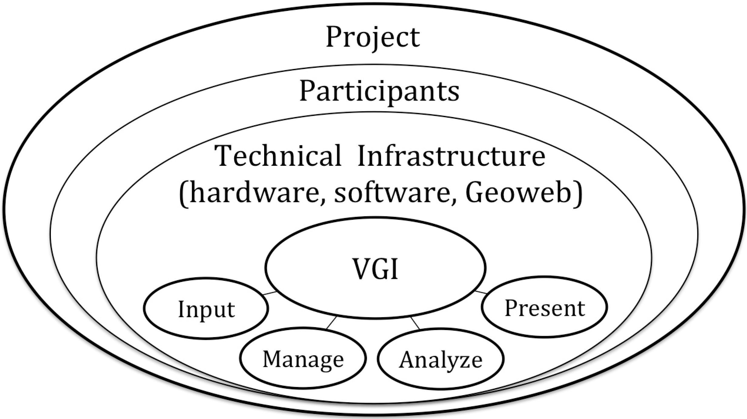
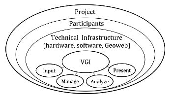
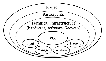
VGI systems can be regarded as an environment for the production of VGI as an information product. The components, which serve as the building blocks for the system, are a complex arrangement between the project and its initiators, the participants who volunteer their geographic information, and the technical infrastructure (hardware, software, and/or the Geoweb); together, these components lead to the creation of a crowdsourced information product, or VGI (see
Figure 1). Within the technical infrastructure, the functions allow for the input, management, analysis, and presentation of VGI. Mimicking Chrisman’s [
39] nested rings used to understand how GIS operates, VGI systems consist of interdependent components with interactions that address technical, contextual, and organizational considerations. Further, the considerations within each component have a substantial impact on the entire VGI system, and subsequently, on the VGI produced. Although the framework needs to be tailored to fit specific projects, we illustrate each component using OpenStreetMap, Ushahidi, and RinkWatch as examples.
Figure 1.
The components of volunteered geographic information (VGI) systems.
Figure 1.
The components of volunteered geographic information (VGI) systems.
4.1. Project
VGI systems are often initiated around a problem or a purpose, and are executed through a project. Projects can be triggered by an event, such as a political crisis or natural disaster. Ushahidi, for example, was first initiated in response to the political upheaval following Kenya’s 2007 presidential election [
19]. Alternatively, there is the less urgent (but arguably equally important) need to gather and share topographic or thematic geo-information, such as in the cases of OpenStreetMap and RinkWatch. Regardless of the initiating motivations, the goal and strategy of all VGI systems need to be clearly defined at the onset of a project. Otherwise, a project might suffer a similar fate as the thousands of Ushahidi maps that have ended up in the “Ushahidi graveyard”; a collection of purposeless crowd maps [
40]. Although some now-defunct maps did serve as learning and training tools for those experimenting with crowdmapping, the graveyard is an important reminder to consider the purpose and plan for sustainability within a project.
The project is often closely related to the domain of the initiator, and in the early stages of VGI system development, the initiators have the greatest control over the design. As individuals or groups, they make important methodological decisions that influence the VGI produced. Key considerations include the study location (e.g., global, Kenya, or Canada), and the timeframe of the project (e.g., ongoing, immediate emergency response, or duration of a funded research project). In traditional GIS, the people component typically refers to professionals (
i.e., researchers, consultants, or technicians) and applications are tied to institutions (
i.e., academic, business, or government) [
38]. In VGI systems, on the other hand, the people initiating the application still plan, implement, and operate the system but may not have formal training in GIS or institutional ties, and often present a unique arrangement between subject, producer, communicator, and consumer [
41].
Despite the changing roles between producers and users, or “produsers” [
15], the initiators leading the development of VGI systems have typically been associated with grass-roots movements, and encompass individuals, community groups, and organizations. Such is the case with Ushahidi, which was initiated by a group of Kenyan activists led by Okolloh, a prominent Kenyan blogger [
19]. However, the increasing institutional interest in VGI and crowdmapping, especially by government, represents a more traditional top-down approach and introduces a new set of incentives for initiating VGI systems. In the report on crowdsourcing geographic information by Haklay
et al. [
1], each of the 29 case studies presented include various levels of government involvement. The interactions, or information flows, were broadly categorized as: public-government, government-public-government, or, public-government-public. Regardless of the domain of the initiators, they ultimately make critical decisions about the participation strategy and technical infrastructure used, as discussed next.
4.2. Participants
Within the application area, project initiators need to identify from whom they wish to collect the VGI. This participation strategy varies substantially between projects. Related to geographical citizen science specifically, Haklay [
21] identifies that the role of the volunteer can be “active” or “passive”. We believe this concept extends to VGI, where participants can contribute VGI both actively and passively. With projects aimed at collecting active contributions, the participants are often drawn from an engaged group of stakeholders such as a purposely selected community group, a pre-selected segment of the population, a set of authorized and trusted contributors, or unknown contributors motivated via a media or outreach campaign. In the case of RinkWatch, initiators identify those who maintain backyard ice rinks as their primary participants, while OpenStreetMap relies on a broad range of participants to contribute information on their local community [
12,
25]. In all cases of VGI systems aimed at collecting active content, the participant “is expected to consciously contribute to the observation or the analysis” [
21].
Conversely, in projects that aim to gather passive contributions, “the contributor is acting more as an observation platform and the data are gathered without active engagement” [
21]. In these types of projects, the participants use technology, such as GPS transmitting a signal from a smart phone or other hand-held device. Although the participant may not be actively volunteering content, such as logging into a Geoweb environment and adding a contribution to a map, they are volunteering to contribute their geo-information. A well-known case of passive contribution is Google Maps application that employs user-authorized GPS information to crowdsource traffic information [
42]. It is important to note that active and passive content is not mutually exclusive. OpenStreetMap, for example, relies on passive contributions when a participant uses GPS tracking to map a road, and relies on active contributions to clean the GPS recordings and add relevant attribute data [
12].
In many projects, a well-defined methodology for generating participation increases the likelihood of volunteer contributions. Thus, a major consideration related to participants is the media or promotional strategy employed. In addition to social media as an obvious avenue for promotion, combining web outreach with more traditional media, including radio and newspapers, has proven to increase the reach of a project. For example, RinkWatch organizers observed spikes in participation on their website during promotional campaigns and most notably, when the project was picked up by the local newspaper and national radio [
43]. Because of the variability within VGI systems, suitable media strategies are contingent upon the project at hand. Although there is not yet an established methodology for generating participation in VGI systems, purposefully devising a participation strategy could lead to a greater understanding of the type of VGI created.
4.3. Technical Infrastructure: Hardware, Software, and the Geoweb
A technical infrastructure supports the creation of VGI, and each system depends on a unique array of hardware and software components. The combination of technical infrastructure deployed ultimately depends on the type of VGI desired, and varies greatly across projects. VGI systems hardware can include server and client computers, and location-enabled devices, such as GPS units and smart phones. The software component can include proprietary and open-source platforms, such as ArcGIS Online (e.g., RinkWatch) or Ushahidi, respectively. There are also two sides to the technical infrastructure: the user interfaces or client-side architecture, and the developer or server-side architecture. OpenStreetMap, for example, relies on navigation (e.g., GPS), desktop computer, and server hardware, and dozens (if not hundreds) of software options (for more, see the OSM wiki [
44]).
The compilation of hardware and software that enable web mapping is more commonly understood as the Geoweb, a collection of online location-enabled services and infrastructure. Initially limited to a one-way flow of information from producers to users, the Geoweb evolved to be participatory, enabling a two-way flow of information and thus facilitating the production of VGI [
7]. The Geoweb can provide the user interface for the collection of VGI. However, not all Geoweb infrastructures are capable of collecting VGI; similarly, not all VGI is collected by way of the Geoweb. One notable advantage of the Geoweb is the layers of geo-information that support the mapping interface, which provide geographic context and allow contributors to identify the relevant geographic area (
i.e., seed content).
The technical infrastructure employed also dictates the functions available to create and manage VGI. Although there are a host of functionalities within the spectrum of VGI systems, we define the main functional groups (in analogy to GIS) as input, management, analysis, and presentation. An example of the technical infrastructure supporting the collection of VGI is the Ushahidi platform; an open-source self-contained Geoweb tool with customizable crowdmapping options. Initially designed to facilitate the sharing of information during the Kenyan election crisis, it has been repurposed thousands of times to gather a diversity of spatial information from the crowd [
19].
Zook
et al. [
14] profiled Ushahidi and three other web-based mapping services (CrisisCamp Haiti, OpenStreetMap, and GeoCommons) that were deployed to crowdsource disaster relief during the 2010 Haitian earthquake. The Ushahidi platform demonstrates the unique data input options, including text messaging (short message service, SMS) and Twitter, which allow project initiators to gather local, on-the-ground knowledge [
14]. Beyond the input functions, the Ushahidi platform also offers functionality for management (e.g., administrator approval of participant contributions), analysis (e.g., contributor statistics), and presentation (e.g., interactive web map) of the VGI within the technical environment. With an abundance of hardware, software, and Geoweb considerations and combinations available for VGI systems, coupled with an array of functional options, the technical infrastructure needs to be evaluated on a system-by-system basis.
6. Conclusions and Future Research Directions
This paper presented an investigation into the creation of VGI from a systems perspective. VGI itself is understood as a crowdsourced geographic information product, while VGI systems enable the creation of VGI. The VGI system framework breaks down the process of creating VGI into three connected components: the underlying project, the participants, and the technical infrastructure. By identifying these primary components, and the considerations within each one, those initiating VGI systems are better able to make informed decisions on the system design, which will ultimately influence the outcomes, whether the desired outcome is to generate new geographic information or promote greater collaboration. Overall, VGI has the potential to add to our collection of maps and spatial data and serve as an information source that can enrich our research programs. VGI systems, then, should be viewed as a method to harness the crowd and connect us to the phenomena we are most interested in studying.
There is more to add to this conversation. As concluded by Hardy
et al. [
27], “research on VGI production is a nascent area with many unexplored avenues.” To date, VGI remains largely untapped as a resource for exploratory and analytical research [
13]. Now that we have established a conceptual framework for the many moving parts that make up VGI systems, we need to evaluate how existing projects apply the components and functions within the framework. Adding to Beaudreau, Johnson, and Sieber’s [
16] research on strategic choices made when developing Geoweb applications, we need to evaluate the strategic choices made during VGI system development, and the impact those choices have on the resulting VGI.
Next, within the VGI systems framework, we did not address temporal considerations. Recent research by Resch [
62] emphasized the importance of incorporating (near) real-time collection of observations and measurements from both people as sensors (or what we describe as active) and collective sensing (passive) networks. Future work could explore incorporating sensor networks into VGI systems to enable real-time monitoring. Finally, it is necessary to explore Geoweb environments that are capable of supporting the collection of VGI. While Ushahidi and OpenStreetMap are good examples of Geoweb platforms that support VGI systems, the increasing interest in crowdmapping from public, private, and non-profit sectors necessitate a more strategic review of the tools readily available to support VGI systems. It is only once the system is understood that we can better implement VGI as a viable approach to address the host of geographic problems that may arise in the future.
