
Environmental and Land-Use Changes as a Consequence of Land Reform in the Urej River Catchment (Western Tajikistan)

1
Institute of Earth Sciences, Faculty of Natural Sciences, University of Silesia in Katowice, Będzińska 60, 41-200 Sosnowiec, Poland
2
Śląskie Laboratorium GIS (ŚLabGIS), Centre for Polar Studies, University of Silesia in Katowice, Będzińska 60, 41-200 Sosnowiec, Poland
3
Department of Medical Biology and Genetics, Faculty of Medical Prevention, Public Health and Medical Biology, Samarkand State Medical University, 18 Amir Temur Street, Samarkand 140100, Uzbekistan
*
Author to whom correspondence should be addressed.
Resources 2024, 13(4), 59; https://doi.org/10.3390/resources13040059
Submission received: 16 February 2024
/
Revised: 15 April 2024
/
Accepted: 15 April 2024
/
Published: 19 April 2024
Abstract
:Mountain societies are strongly linked to natural resources and their rational management. The growing population has led to the management of mountain areas according to emerging human needs. The study was conducted in the Urej River catchment (The Fann Mountains, Tajikistan). This paper aims to present changes in land use in 1988–2023 resulting from environmental conditions and land reform. Pasturelands predominate in the study area (93.8%), while built-up with kitchen garden and irrigated areas cover 1.8% and 4.0% of the area, respectively. Kitchen gardens and irrigated areas provide food for the residents. Significant land-use changes were observed along the Uroz River, where the irrigation system was developed in areas that have not yet been used for plant cultivation. This is typical of many areas in Tajikistan, where it is impossible to obtain crops without irrigation due to climatic conditions. Until 1988, the study area was not as intensively cultivated as it is today. Under the ongoing lease system based on the Dehkan Farm Act, grazing land is still owned by the state, but inhabitants have access to it. The leased land does little to improve the economic situation of households but contributes to preventing ecosystem degradation on the slopes caused by humans.
1. Introduction
Covering 22% of the globe’s total land area and being home to 13% of the world’s population [1], mountains provide habitats for various plant organisms [2]. They are a very complex geosystem and, simultaneously, a susceptible ecosystem, especially to human pressure [3,4,5]. Although montane species are well adapted to life at extremes, they are highly vulnerable to human-derived ecosystem threats [6]. Mountain areas are characterised by highly diverse climatic conditions depending on their altitude and topoclimatic diversity determined by the degree of slope and aspect of the terrain. The diversity of mountain habitats results in a highly varied pattern of ecosystem services of diverse availability and land use by local communities, such as providing food crops and fodder for domestic animals [7,8,9,10,11]. Approximately 13% of the world’s population is directly dependent on mountain ecosystems that provide a variety of ecosystem services [1,12,13]. Nowadays, human activity is the primary factor influencing ecosystem processes in many mountain regions of the world. As a result, current vegetation is primarily shaped by historical and current land use [14]. Human activity shapes the structure of biogeocenoses as a whole; it causes both its simplification, the simplification of the trophic level and the reduction of the differentiation between different plant zones [15]. The degree of influence depends mainly on the area’s accessibility [16].
While in developed countries the post-abandonment reforestation of former agricultural lands represents a major land-use change of global importance [17], in other areas, human pressure and deforestation are still of great global concern [18]. This pressure is usually associated with low-income countries in Latin America, Africa and Asia that are in the deforestation phase of the forest transition [19]. The increasing human pressure concerns, among others, the Republic of Tajikistan in Central Asia and is connected with an ongoing increase in population [20]. Studies on land-use and land-cover (LULC) changes in Tajikistan are rare [21]. Until now, land-use changes in Central Asia have been presented on a large scale [22,23,24,25,26], and there is a lack of studies on particular regions that are very varied in terms of human activity. It should be emphasised that 93% of the country’s area is mountainous, and agricultural land is most often found on river terraces. Settlements located in high mountain areas, far from urban centres, are often left to fend for themselves and are self-sufficient in their daily needs. This is possible due to the increased use of developing areas that were previously not used for growing basic vegetables and fruit. This activity has developed intensively in the Urej Valley over the past 30 years. Human management of large river valleys and their surroundings through irrigation for cotton production concerned the post-Soviet countries of Central Asia, which led to an ecological disaster and contributed to the drying up of the Aral Sea [27].
In the Urej River Valley, like in most of Tajikistan, the human impact on the functioning of mountain ecosystems has not been assessed yet [28,29,30,31,32,33,34]. There were only some studies on the vegetation and land use in this area against the background of the whole Zeravshan Mountains. As a result, these studies are pretty general [35,36]. There is still a lack of studies on the human impact and consequences of LULC changes, even though the area is very attractive regarding nature and ecotourism [37].
During the Soviet era, most of the land now used in the Urej River catchment and other parts of Tajikistan was state-owned pastureland stewardship by collective farms (kolkhozes) or by state farms (sovkhozes) [38]. As these production systems proved highly inefficient after the collapse of the USSR, land reforms were introduced in the new Central Asian states soon after their independence [39,40,41]. To increase productivity and avoid land degradation, collective and state farms have been largely privatised, leading to different approaches to the stewardship of agricultural land and pastureland. In most cases, these farms were dissolved, and their land and livestock assets were equally distributed to the households of former workers. However, in some cases, pastures remained state property [42,43,44,45]. These pasturelands can now be leased under certain rules resulting from the land reform. In Tajikistan, state farm assets in the form of livestock were distributed to individual households from 1999 onwards [46,47]. However, although the state still owns pasturelands, inhabitants have access to the pasturelands under a lease system based on the Dehkan Farm (chojagii dehqoni in the Tajik language) Law [48]. This reform began to be implemented in the first half of the 1990s and was modified a few times [49,50]. These farms were divided and irrigated, while in the Urej River catchment, the land at that time was already occupied by households in the form of kitchen gardens. These kitchen gardens are one of the most important land-use forms in the Urej Valley and across Tajikistan. They are small-scale private properties of economic and cultural significance in post-Soviet Central Asia [51]. For this reason, the increasing local population began to develop previously unirrigated areas on a large scale, quickly leading to significant land-cover changes. The aim of this article was to determine and analyse changes in land use in the Urej catchment over the last 35 years, resulting from environmental and political conditions and land reform.
2. Materials and Methods
2.1. Study Area
The Fann Mountains are a unique place called the country of mountains. Their ancient name is Kuhistan (Kuh from Farsi—mountains, istan—place). They are located in Central Asia at the junction of two huge mountain ridges—Zeravshan and Hisor—in the Pamiro-Alai chain system [52]. Thanks to their exceptional and unique landscape, they have been called the pearl of the Pamir-Alay Mountains (Figure 1).
Geologically, it is made up of alluvial fans dated to the late Quaternary (Holocene) Period and Mesozoic lithologies abutting a granite batholith in the higher parts of the Fann Mountains [36]. The Fann Mountains are characterised by high relative heights in relatively small distances. The highest peaks rise to altitudes of more than 5000 m and relative elevations of up to 1500 m. The highest point in the Fann Mountains is Chimtarga Peak (5489 m a.s.l.). This undoubtedly has a significant impact on scenic diversity and its mosaicist. High, steep ridges and deep, narrow valleys foster processes of intense downwash, which destroy the soil cover down to the bedrock. The soil cover is heterogeneous in terms of mechanical composition and development stage. Soils range from fine-grained to poorly developed coarse-grained skeleton soils depending on the topography, aspect, altitude and vegetation. Specific physiogeographic features of the study area determine the formation of particular types of mountain soils: mountain-brown (Cambisols), sandy-desert (Arenosols), floodplain/meadow/marsh (Fluvisols) and all variants of grey soils (light brown, typical and dark) [53]. The soils in managed areas and yards are regularly fertilised mainly with animal manure and are referred to as Hortisols.
Mean temperatures reach about 15–16 °C in summer with a maximum of 25–26 °C and −5 to −8 °C in winter with a minimum of −25 to −26 °C. The period without ground or air frost reaches 90–100 days per year [29]. Air temperatures tend to depend strongly on the altitude. The vertical gradient of the mean yearly temperature in the Zeravshan (Zarafshon) Range is −0.65 °C/100 m. The temperature drops from about 10.5 °C at 1680–1700 m a.s.l. at the mouth of the Urej River to the Kishtut River to 0 °C at the altitude of 3200 m a.s.l. near the Kulikalon Lakes to about −5 °C at about 4000 m a.s.l. at the lower glacier and snowline. At the highest Chimtarga Peak (5489 m a.s.l), it is estimated at about −15 °C [54].
2.2. Material and Methods
The methods used in the present study consisted of a field study and a spatial analysis. The field study consisted mainly of in situ observations, photographic documentation and field mapping of vegetation and land use. The desk part was related to remote sensing spatial analyses in GIS software based on satellite data and a digital elevation model.
The detailed field studies were conducted in the catchment of the Urej River (the left tributary of Zeravshan river) two times. Firstly, at the end of the 1980s, field mapping of build-up areas, kitchen gardens and kolkhoz areas was carried out. Based on this field mapping, topographic sketches were drawn and photographic documentation was taken to archive the state of the environment and selected elements of land use at that time. Next, these sketches were vectorized in GIS software and georeferenced in accordance with contemporary base maps. The second approach was conducted in the summer of 2023. In order to identify and accurately summarize in the form of a map the state of the environment and types of land use in 2023, satellite imagery was used. The satellite data used as basemaps for contemporary land use and vegetation mapping were Bing Virtual Earth (2023), Esri Imagery (2023) and Google Satellite (2023). In order to maintain precision and spatial compatibility, the same WGS 84/Pseudo-Mercator coordinate system (EPSG:3857) [55] was used for all spatial data, i.e., satellite imagery, created vectored data, digital terrain model. In addition, we used a global digital surface model AW3D30 (AW3D30, 2017) [56]. This model has a spatial horizontal resolution of 24 × 30 m and an accuracy of 5 m (vertical and horizontal) and was released by the Japan Aerospace Exploration Agency [57,58]. All spatial analyses, maps and digitisations were performed in GIS software: ArcGIS 10.8.1 [59] and QGIS 3.32.1 [60].
Subsequently, all land-cover forms and vegetation types distinguished on the satellite data and base maps were verified during field studies in the summer of 2023. As a result, a land-cover map presenting the land use in 2023 was prepared. A comparison of land-use change between 1988 and 2023 was carried out only in the settled and farming sections of the river. Land-use field mapping was necessary as not all land-use types were easy to detect based on satellite image interpretation. To this aim, an itinerary method and interpretation of satellite imagery were used [28,29]. The itinerary method is a class of methods realised by repeated surveys along the route, which can be multi-scale, covering small patches of vegetation or whole areas, and they differ in precision, i.e., they are based on strictly visual estimates and detailed vegetation analysis methods. During vegetation mapping, Latin plant names were given on the basis of Flora of Tajik SSR [61].
3. Results
3.1. Topography of the Urej Catchment
The study catchment area of the Urej River covers more than 273 km2. This catchment is located in a mountainous area: the highest places reach heights of more than 5000 m a.s.l., and the lowest only reach 1343 m a.s.l. (Figure 2). Such significant differences in altitude (more than 3700 m) in such a small area cause a considerable variation in topography. The main morphological feature is the largest valley of the Urej River, which has a length of more than 30 km. The smaller river valleys tributary to the main Urej River range in length from about 3 km (Obi-Zuba) to over 9 km (Tandara) (Figure 2).
The vast majority of the catchment area includes gradients of more than 40° (almost 98% sic!) (Figure 3A). The flattest surfaces (0–20°) occupy only 1.9 km2 (0.7%) and are located in the Kulikalon Basin or around the village of Artuch (Figure 3A). Medium slopes (20–40°) also allow human functioning in this area.
Aspect is an essential element of the topography that determines the local climate. A detailed analysis of the aspects map shows a regular distribution of southern and western slopes in the eastern part of the area and northern and eastern slopes in the southern and western parts of the study area (Figure 3B). The northern slopes (more than 33%), southern slopes (more than 29%) and western slopes (about 26%) are the most numerous, while the eastern slopes (about 11%) are the least.
3.2. Land Cover in 2023 in Urej Catchment
The catchment of the Urej River and its tributaries are located in a mountainous area characterized by massive ridges, steep slopes, scree and landslides, while flat areas suitable for cultivation are the least frequent (Figure 2 and Figure 3). A glacial and snowy regime characterizes the river. The catchment is dominated by steep slopes of more than 60°, some of which are devoid of soil cover, and the bedrock is on the ground surface due to water and wind erosion.
According to the land-use classification of Tajikistan, the study area includes residential, agricultural (irrigation) and livestock grazing (pasturelands) areas, which themselves include alpine meadows, forest/shrub ecosystems and typical Central Asian juniper forests (Figure 4 and Figure 5). The latter occur throughout the study area mainly in scattered and rarely in dense forms. The largest areas of pastureland are dominated by juniper woodland with Juniperus seravschanica and J. semiglobosa (37.1%), alpine meadows (17.8%), rocky surfaces and scree with vegetation (13.5%) (Table 1). Sparse juniper forests are mainly found on gentle and lower-lying southern slopes and in places on eastern and northern slopes. In contrast, dense forests occupy steep (>60°) northern and in places western slopes (Figure 3 and Figure 4).
3.3. Natural Vegetation Changes
3.3.1. Forest Vegetation
The junipers in the study area are represented by two formations: a thermophilous one with Juniperus seravschanica and an oligothermic one with J. semiglobosa. As mentioned above, they cover more than 37% of the area and environmental conditions determine their distribution. J. semoglobosa occupies the higher-located areas, between 2700 and 3200 m a.s.l. This formation of juniper woodland dominates in the study area and is characterised by different degrees of density (Figure 6). J. seravschanica occurs at lower altitudes (1500 to 2400 m a.s.l.). Regarding species composition, they are both similar, apart from a single dominant species resulting from terrain and habitat conditions. Among the shrubs, Lonicera simulatrix, L. korolkovii, Cerasus verrucosa, Spiraea hypericifolia, Berberis oblonga, Rosa Fedtschenkoana, R. kokanica, Sorbus tianschanica, etc. are the most characteristic. They occur sporadically and do not form a distinct layer in the community. As far as the herbaceous vegetation is concerned, the following species occur: Thymus seravschanicus, Ziziphora clinopodioides, Festuca sulcata, Poa relaxa, Eremopoa persica, Astragalus lasiosemius, Ferula kokanica, Gentiana olivieri, Erigeron cabulicus, Asperula setosa, Silene tachtensis, Asyneume attenuatum, Polygonum coriarium, P. hissaricum, Nepeta podostachis, Acantholimon velutinum, Piptatherum sogdianum, Veronica biloba, Astragalus platyphyllus, Trigonella adscendens, Oxytropis Lehmanniana, Cousinia verticillaris, C. splendida, Ligularia thomsonii, Campanula lehmanniana, Elytrigia trichophorum, Piptatherum sogdianum, Hordeum brevisubulatum, etc.
3.3.2. Scrub Vegetation along River Ecosystems
In various parts of the Urej River catchment, tugai vegetation develops on its floodplain as a narrow strip (depending on its width). In the upper and middle sections, the river flows through a narrow gorge between rocky outcrops and rocky shores (in the case of the Tandara River), where small or single species of shrubs are found. Here, in addition to Salix linearifolia, P. talassica, Lonicera simulatrix, L. zeravschanica, Rosa ecae, Cerasus verrucosa, Ephédra equisetína, Cotoneaster multiflora, Salix capusii and Hippophae rhamnoides, dense thickets occur in some places. In the luxuriant herbage, Carex pachystilis, C. turkestanica, Anizantha tectorum, Eremopoa persica, Poa bulbosa, Ziziphora tenuior, Allyssum desertorum, Astragalus tibetanus, Piptatherum alpestre, Potentilla orientalis and many others are predominant.
3.3.3. Ticket Vegetation on South Slopes
On the southern slopes, communities of thyme (with domination of Thymus seravschanicus) and Juniperus seravschanica are formed, confined to low-moisture habitats. The most typical of the shrubs are L. simulatrix, C. verrucosa, Spiraea hypericifolia, B. oblonga, R. fedtschenkoana, etc. They are found singly and do not form a distinct layer. In the herbs layer, in addition to the dominant Thymus seravschanicus, Ziziphora clinopodioides, Festuca sulcata, Poa relaxa, Eremopoa persica, Astragalus lasiosemius and Ferula kokanica are common.
3.3.4. Non-Forest Vegetation
In open and sunny areas, high-mountain steppes with the following species are formed: Artemisia dracunculus, Stipa kirghisorum S. caucasica S. trichoides, Festuca sulcata, F. alaica, Zerna turkestanica, Z. angrenica Adonis turkestanicus, Hordeum turkestanicum and Poa relaxa (Figure 7).
At the highest altitudes (3000–3100 m a.s.l.), highly mobile scree dominates with individually scattered pioneer plant species (Figure 8): Stilpnophleum laguroides, Allium polyphyllum, Aconitum seravschanicum, Polygonum hissaricum, Dydimophysia Fedtschenkoana and Nepeta kokanica. On less mobile scree (Figure 6), small open groupings are formed from various combinations of the above species, often Rheum Fedtschenkoi, Rhodiola heterodonta, Angelica ternata, Astragalus chionanthus and Dracocephalum oblongifolium.
3.4. Land-Use Changes in the Uroz and Urej River Valley in 1988–2023
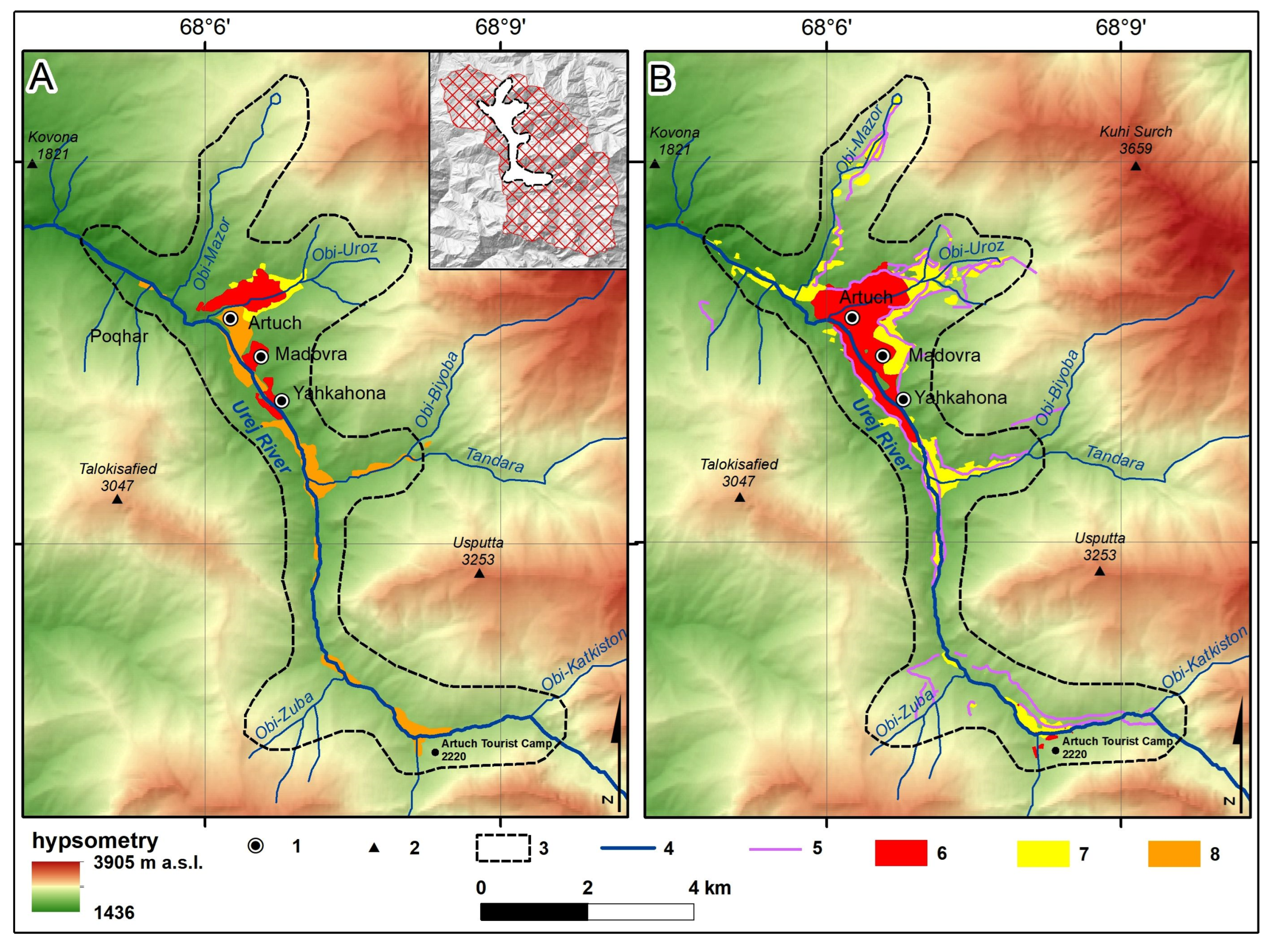
In the valleys of the Uroz (also known as the Artuch or Obi-Uroz) and Urej Rivers, there are small areas of flat land (floodplain) for land cultivation. Until the end of 1988, these valleys were not as intensively cultivated as they are today (Figure 9A,B; Table 2). The changes in land use were possible due to the development of irrigation systems on previous pasturelands (Figure 9B).
Until 1988, small fragments of land in the Artuch settlement were cultivated (Figure 9A). By 2023, the entire valley had already been mainly utilized for growing food crops but also for producing fodder for domestic animals (Figure 9B). The settlements of Artuch, Madovra and Yakkachona were smaller and located separately, and today, they form one settlement entity with three names. The areas outside the development area belonged to the kolkhozes (collective farms with an area of 1.94 km2). In this area, Nicotiana tabacum was grown as fodder for the animals belonging to the kolkhoz. Irrigated areas belonging to collective farms were distributed to farmers, and according to the law in Tajikistan, everyone is entitled to 6 sotiqs (600 square meters) of land from the state. Such areas were supposed to be sufficient to build a house and establish a kitchen garden.
3.4.1. Land Leaseholds
The 1990s were difficult for families in the high mountain areas due to the civil war in Tajikistan. During the period of political chaos, people without permits occupied areas near the settlement of Artuch and even far from it (Figure 9B). The owners later documented these areas. Initially, areas close to the river were chosen because they were easier to irrigate. Without this, there was no possibility of yields, as the prevailing climate is dry and rainfall is very scarce during the development period of the plants to ensure their proper functioning.
After the land reform, the areas managed in the studied catchment were called arendas (land leased from the state), most often including non-irrigated areas in the analysed catchment. Later, these areas were irrigated by digging artificial and often very long irrigation canals (Figure 9B). In this way, arendas were created along the entire Uroz River, starting from its spring section. Figure 10 shows changes in land use over the last 20 years.
3.4.2. Kitchen Gardens
The specific type of agricultural land located directly in households and dwellings within the settlement, supplying fresh fruit and vegetables to the inhabitants, is obchakoria (so-called kitchen gardens). These kitchen gardens cover significant areas in the study area (Figure 9 and Figure 10). On small plots, onions, carrots, tomatoes, cucumbers, potatoes and fruits such as cherries, pears and apple trees are grown. The steep slopes are used to produce hay and grain, mainly for animals. In the event of a good yield, produce is sold. Populus tremula, P. alba and species of the genus Salix also grow in such gardens as fuel and building material for commercial purposes. Areas with kitchen gardens in such situations are transformed into forest areas. Thanks to this, large areas under irrigation and development of former pasturelands were transformed into anthropogenic poplar/willow forests, and their range overlaps with kitchen gardens.
4. Discussion
4.1. Land-Use Changes in Urej Catchment
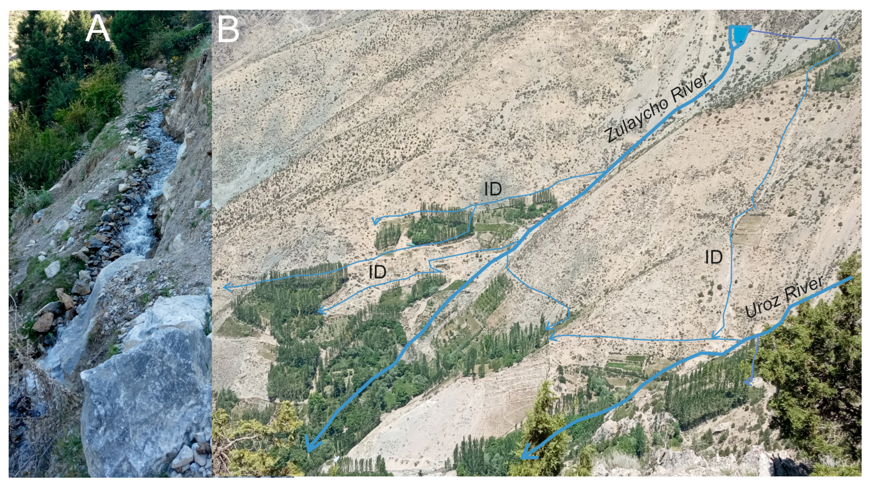
Changes in land use are influenced by the study area’s location, natural resources, the features of the mountain environment (dry, rocky, sparse forests) and the study area’s accessibility. Compared to other mountain areas in Central Asia, the study area is difficult to access and often impossible to cultivate without irrigation. Potential areas for cultivation are located only in flat parts of river valleys (Figure 3A), additionally equipped with systems of irrigation canals (Figure 11) [36,62]. A typical farm in the Urej River Valley and the whole of Tajikistan is small. Small plots are cultivated, and a small number of animals graze. Agriculture suffers from low crop yields due to insufficient water (in the hills) and nutrient-poor soils [13].
Most importantly, the end of the Soviet system halted supplies to the region from outside, leading to serious supply problems and, consequently, the failure of the lease system [63]. The post-independence civil war in Tajikistan (1992–1997), which forced many refugees to seek refuge in the high mountain villages of the Zeravshan region (including the study area), worsened the situation regarding supplies and livelihoods. A similar situation has been observed in most mountainous regions of Tajikistan [63,64,65,66]. For this reason, people began to lease land from collective farms or develop fragments of pastures that could be easily irrigated without permission to provide household food.
Introducing reforms under the name ‘dehkan farms’ only accelerated this process. Land reform began at the start of the transition to the market economy by the Resolution of Government 16.09.1992 N° 357 regarding measures on land reform in the Republic of Tajikistan [67]. The purpose of this document was to create conditions for the future development of various types of stewardship methods, organize a multi-sector economy and increase agricultural production. As mentioned before, dehkan farms were established after the break-up of large state farms and livestock enterprises as a result of the collapse of the Soviet Union. They can be large (up to 3000 ha) or small and are controlled by individuals, families, co-operatives or collectives [48,68]. Land in Tajikistan is state property and is provided for long-term use by dehkan farms and households. Private farms were formed based on the reorganized Sovkhoz or Kolkhoz collective farms. The legal basis for the organization and activities of dehkan farm in the Republic of Tajikistan was set down in 1992 and is regulated by the law of the Republic of Tajikistan [48,68]. The establishment of dehkan farms contributed to developing and fencing previously pasturing areas near the villages. The local people’s animals grazed all year round, and because of this, they are now facing problems, so most of the communities have given up animal farming. Large families and high-income households use the most significant areas. Preparing such areas for cultivation requires a lot of effort.
The impact of the USSR collapse on changes in land use was also detected in mountain areas of post-soviet European countries [69]. Nevertheless, the direction of land use was completely different. The most prevalent changes in post-soviet European countries were cropland abandonment, conversion of croplands into grasslands and forest expansion on non-forest land. Cropland abandonment was most extensive during the post-socialist transition period and predominantly occurred in marginal areas with low suitability for agriculture, causing the vanishing of traditional landscapes [70]. Conversely, substantial recultivation of formerly abandoned cropland has been observed in high-value agricultural areas since 2000. Hence, market forces increasingly adjust socialist legacies of expansive land production and agricultural land-use clusters in favourable areas, while marginal lands revert to forest. In some areas, nature conservation programmes are implemented to protect the landscape [71]. This process is typical for developed countries and is known as land-use polarization between areas utilized more intensively and more extensively [72]. In the study areas, as well as in other mountain areas in Central Asia, the expansion of agricultural land use is still observed [73]. As a result, in contrast to post-Soviet countries in Eastern Europe, in the mountainous areas of Central Asia, human pressure on the environment is increasing [74].
4.2. Kitchen Gardens
Kitchen gardens occupy significant areas in the study area. From the earliest days of the USSR, Tajik inhabitants were allowed to have small kitchen gardens at or near their homes to enrich their diets with fresh food and raise a dairy cow and other animals. These areas require frequent irrigation due to the dry climate. The Uroz River flowing through the village of Artuch cannot provide enough water to irrigate, so the local people appoint a person to manage the water resources during the growing season of the crops (such a person is called a mirob—he divides the water one by one for each household). Until the 1990s, during the Soviet period, there was a boundary, and it was impossible to use the land beyond it. That was because it was assumed that the water resources of the Uroz River were barely sufficient to irrigate the land below.
Central Asian horticulture is traditionally practised in irrigated plots around the house, in kitchen gardens called obchakori [51]. Gardening is common along the entire Urej and Zeravshan River Valleys (Figure 5, Figure 10 and Figure 12). The high-altitude regions provide favourable conditions for growing vegetables and seed potatoes. Kitchen gardens exist throughout Tajikistan, Uzbekistan and Kyrgyzstan and similarly provide basic food needs [75]. They differ in size, which depends on the availability of water and land for development [76].
4.3. Forest Ecosystem Changes
The main threat to juniper forest ecosystems is human activity. This threat is not connected with cutting down a 500–700-year-old juniper tree [13,33,52,54,77] to obtain one relatively small piece of building material and fuel. Still, it is connected with forest devastation by logging. Junipers will never regenerate, as seedlings emerge and survive mainly under the crowns of the parent trees. Logging is particularly dangerous in the Zeravshan mountains, where the climate is arid. In many gullies in the Urej river basin and elsewhere in Tajikistan, juniper forests have been destroyed. In place of the decimated forests, we now see bare slopes with a washed-out soil horizon and rocky outcrops on the surface [54]. At best, we see slopes with desert vegetation or sclerophyllous shrubs that are secondary, replacing the juniper forests. The juniper forests in the Urej River Basin, especially in the upper part, are the best in the entire catchment. They occupy considerable areas here, form a relatively wide vertical belt and penetrate many phlorocenotypes of woody and shrubby vegetation. They are restricted to the most diverse soil conditions and landforms and they are communities showing considerable phytocenotic diversity [32,78]. Within juniper stands, there are often extensive glades overgrown with herbaceous species [79] that have resulted from the cutting of junipers.
Another important driving force is human dependence on livestock as the primary source of income in many other Asian countries, such as Kyrgyzstan, Uzbekistan and others [7], which may affect the functioning of ecosystems in a dry environment. The situation is entirely different in the Fann Mountains, where most households have given up animal farming due to the lack of pastures in the area where they live and the high feed cost. They buy animal products only in supermarkets, and the money is provided by household members working abroad (mainly in the Russian Federation). This, in turn, affects the regeneration of early degraded ecosystems [13].
4.4. Environmental Consequences of Land Use
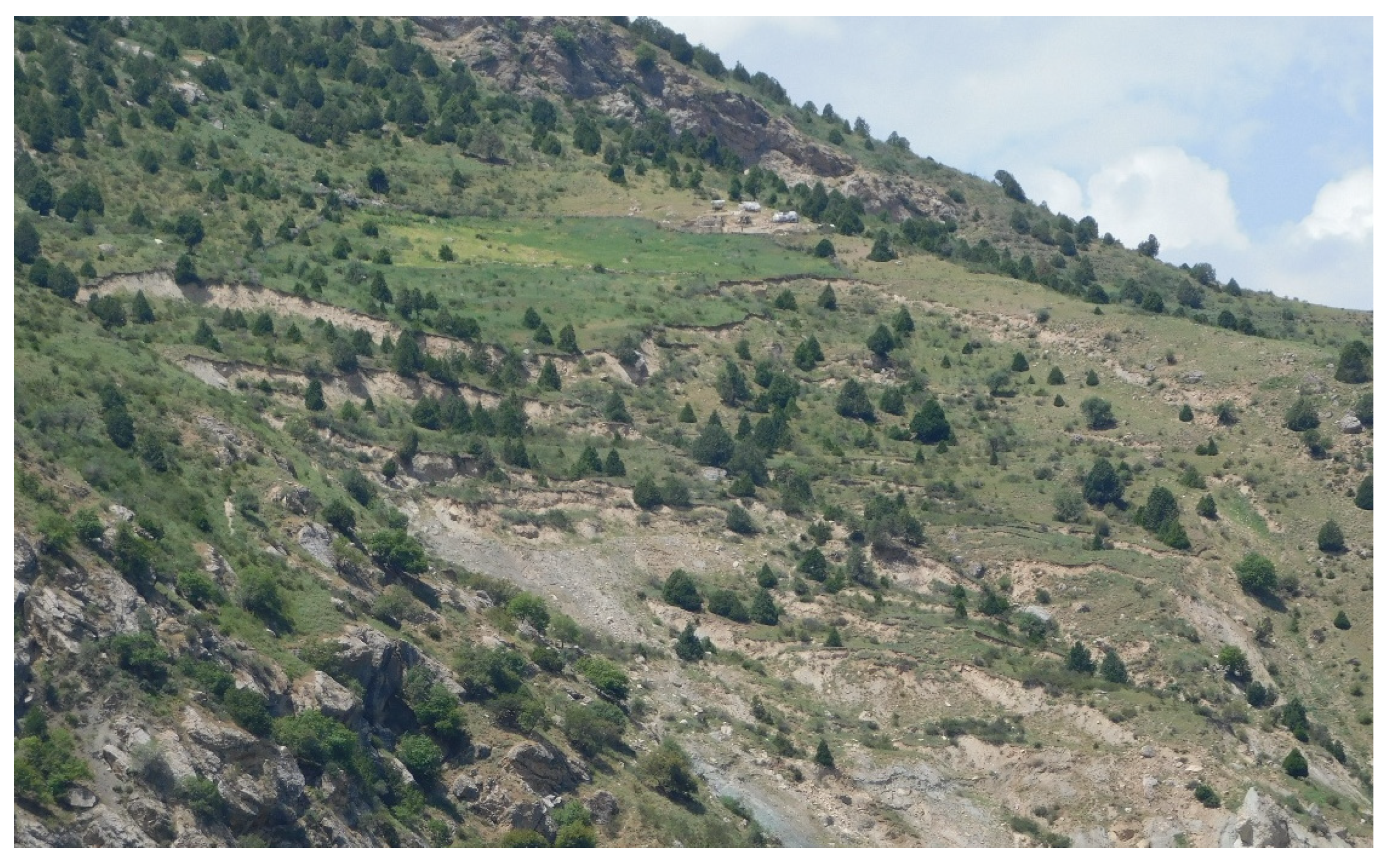
The disturbance of high mountain ecosystems in the Urej River catchment is caused by previously inaccessible, non-irrigated, and also irrigated land. Water is supplied by irrigation ditches several kilometres long running up steep slopes. These ditches were made with primitive digging tools and are constantly exposed to damage because the ground is often saturated with water, and, as a result, landslides can cause irreversible damage to both land and household resources. At this point, some of the land has already been mechanically eroded. On the one hand, this causes erosion and, on the other one, a dramatic transformation of the biogeocenoses in areas high above the rivers. On the other hand, valley areas, together with wet meadows and parts of peatlands, have been transformed into areas for fodder production [36]. In addition, they are fertilised and, flowing out of the cultivated area, pollute the waters with pesticides. The effect of irrigation also affects the composition of the flora of the surrounding area. Thus, local endemics are replaced by other species.
Another element influencing the dysregulation of high-mountain ecosystems is using previously inaccessible areas through irrigation. Water is supplied through drainage ditches on steep slopes, often several kilometres long [13]. The environmental changes that have taken place are, on the one hand, positive in the area being forested and, on the other, negative due to over-watering and soil degradation due to soil creep (Figure 13).
Contemporary climate change may have a negative impact on the water abundance of these regions (glaciers are already shrinking), which may, in turn, exert a colossal negative impact on the functioning of high-mountain societies. Both an excess and lack of water influence the sustainable use of the vulnerable high-mountain ecosystem [6]. The threat of climate change further intensifies the negative impacts of drought [62]. The result is soil erosion and, consequently, significant transformations in biogeocoenoses. Climate change, land degradation and drought affect millions of people living in drylands worldwide. With its food security depending almost entirely on irrigated agriculture, Central Asia is one of the arid regions highly vulnerable to water scarcity [80], but it is also interesting from the touristic point of view [81].
Pastures are the dominant component of all land uses in the Urej River catchment. Pasture areas are used according to seasons: summer pasture, winter pasture and spring/autumn pasture. As a result of land cultivation and animal grazing, the following landforms have developed: stone walls, mounds and enclosures, agricultural terraces and beaten paths typical of areas intensively used for animal grazing (Figure 14). These forms are typical of many mountain areas worldwide [82]. They are visible not only in areas that are currently utilised but can persist for decades or centuries after land abandonment [83,84,85].
5. Conclusions
The changes in land use in the Urej River catchment have been very rapid over the past 40 years. For the most part, the irrigated areas were owned by the state and managed by collective farms, some of which were used to produce fodder for kolkhoz animals that were used to plough the land and some for the transport of animals (mainly horses). The other part was used to grow tobacco. After the collapse of the USSR, the kolkhozes ceased to function, and the irrigated land was allocated to families who did not have their own home gardens. On the other hand, against the backdrop of the political chaos of the 1990s (civil war), people began to occupy non-irrigated land (grazing land) along rivers in entire river catchments without permission. During this period and after the implementation of the land reform, land near or along the Uroz River along its entire stretch began to be developed on a large scale by local inhabitants. Land use along the different sections of the rivers was determined by the relief of the terrain and the possibility of irrigation. Artificial canals have been created over a considerable area to irrigate the area. Nowadays, irrigation systems are longer than natural rivers. The process of building these canals has led to significant environmental changes. As a result, much of the pastureland has been changed into kitchen gardens, where vegetables, fruit and wood are mainly obtained. The environmental changes that have taken place are, on the one hand, positive in terms of the wooded area and, on the other one, negative due to excessive irrigation and the initiation of soil creep. Sustainable land use in this area is closely related to the economic conditions of individual households. Improving economic conditions could help regenerate the environment because people will not have to exploit the land.
Author Contributions
Conceptualisation, O.R.; methodology, O.R.; software, B.S.; validation, O.R. and Z.B.I.; formal analysis, B.S.; investigation, O.R., B.S., Z.B.I. and M.S.; resources, O.R., B.S., Z.B.I. and M.S.; writing—original draft preparation, O.R. and M.S.; writing—review and editing, O.R. and M.S. All authors have read and agreed to the published version of the manuscript.
Funding
This research received no external funding.
Data Availability Statement
The data are available upon specific request to the authors.
Acknowledgments
We gratefully acknowledge the anonymous reviewers for their constructive comments. We would like to thank the community of Artuch village, which helped us through in-depth interviews, thanks to which we were able to obtain additional information about changes in land use.
Conflicts of Interest
The authors declare no conflicts of interest.
References
- FAO. Mapping the Vulnerability of Mountain Peoples to Food Insecurity; Food and Agriculture Organization of the United Nations: Rome, Italy, 2015. [Google Scholar]
- Chaudhary, S.; Tshering, D.; Phuntsho, T.; Uddin, K.; Shakya, B.; Chettri, N. Impact of land cover change on a mountain ecosystem and its services: Case study from the Phobjikha valley, Bhutan. Ecosyst. Health Sustain. 2017, 3, 1393314. [Google Scholar] [CrossRef]
- Akhmadov, K.M.; Breckle, S.W.; Breckle, U. Effects of grazing on biodiversity, productivity, and soil erosion of Alpine Pastures in Tajik Mountains. In Land Use Change and Mountain Biodiversity; Spehn, E.M., Liberman, M., Korner, C., Eds.; Taylor & Francis Group: Boca Raton, FL, USA, 2006; pp. 241–249. [Google Scholar]
- Apollo, M.; Andreychouk, V.; Bhattarai, S. Short-term impact of livestock grazing on vegetation and track formation in a high mountain environment: A case study from the Himalayan Miyar Valley (India). Sustainability 2018, 10, 951. [Google Scholar] [CrossRef]
- Apollo, M.; Andreychouk, V. Trampling intensity and vegetation response and recovery according to altitude: An experimental study from the Himalayan Miyar Valley. Resources 2020, 9, 98. [Google Scholar] [CrossRef]
- Schmeller, D.S.; Urbach, D.; Bates, K.; Catalan, J.; Cogălniceanu, D.; Fisher, M.C.; Friesen, J.; Füreder, L.; Gaube, V.; Haver, M.; et al. Scientists’ warning of threats to mountains. Sci. Total Environ. 2022, 853, 158611. [Google Scholar] [CrossRef] [PubMed]
- Squires, V. Better Land Stewardship: An Economic and Environmental Imperative, If There Is to Be Sustainable Development. In Rangeland Stewardship in Central Asia; Squires, V., Ed.; Springer: Dordrecht, The Netherlands, 2012; pp. 31–50. [Google Scholar] [CrossRef]
- Walz, A.; Gret-Regamey, A.; Lavorel, S. Social valuation of ecosystem services in mountain regions. Reg. Environ. Chang. 2016, 16, 1985–1987. [Google Scholar] [CrossRef]
- Schirpke, U.; Tappeiner, U.; Tasser, E. A transnational perspective of global and regional ecosystem service flows from and to mountain regions. Sci. Rep. 2019, 9, 6678. [Google Scholar] [CrossRef] [PubMed]
- Zhao, Q.; Li, J.; Liu, J.; Cuan, Y.; Zhang, C. Integrating supply and demand in cultural ecosystem services assessment: A case study of Cuihua Mountain (China). Environ. Sci. Pollut. Res. 2019, 26, 6065–6076. [Google Scholar] [CrossRef] [PubMed]
- Mo, L.; Liu, J.; Chen, J.; Xie, Y. Quantifying ecosystem services of dominate forests in the Beijing mountain area. Environ. Sci. Pollut. Res. 2020, 27, 27773–27785. [Google Scholar] [CrossRef] [PubMed]
- Wang, Y.; Dai, E.; Yin, L.; Ma, L. Land use/land cover change and the effects on ecosystem services in the Hengduan Mountain region, China. Ecosyst. Serv. 2018, 34, 55–67. [Google Scholar] [CrossRef]
- Rahmonov, O.; Abramowicz, A.; Pukowiec-Kurda, K.; Fagiewicz, K. The link between a high-mountain community and ecosystem services of juniper forests in Fann Mountains (Tajikistan). Ecosyst. Serv. 2021, 48, 101255. [Google Scholar] [CrossRef]
- Lavorel, S.; Grigulis, K.; Leitinger, G.; Kohler, M.; Schirpke, U.; Tappeiner, U. Historical trajectories in land use pattern and grassland ecosystem services in two European alpine landscapes. Reg. Environ. Chang. 2017, 17, 2251–2264. [Google Scholar] [CrossRef] [PubMed]
- Smith, T.; Traxl, D.; Boers, N. Empirical evidence for recent global shifts in vegetation resilience. Nat. Clim. Chang. 2022, 12, 477–484. [Google Scholar] [CrossRef]
- Tasser, E.; Tappeiner, U. Impact of land use changes on mountain vegetation. Appl. Veg. Sci. 2002, 5, 173–184. [Google Scholar] [CrossRef]
- Meli, P.; Holl, K.D.; Rey Benayas, J.M.; Jones, H.P.; Jones, P.C.; Montoya, D.; Moreno Mateos, D. A global review of past land use, climate, and active vs. passive restoration effects on forest recovery. PLoS ONE 2017, 12, e0171368. [Google Scholar] [CrossRef] [PubMed]
- FAO. Global Forest Resources Assessment; Main Report; FAO: Rome, Italy, 2020. [Google Scholar]
- Mather, A.S. The forest transition. Area 1992, 24, 367–379. [Google Scholar]
- Siegfried, T.; Bernauer, T.; Guiennet, R.; Sellars, S.; Robertson, A.W.; Mankin, J.; Brauer-Gottwejn, P.; Yakovlev, A. Will climate change exacerbate water stress in Central Asia? Clim. Chang. 2012, 112, 881–899. [Google Scholar] [CrossRef]
- Mumtaz, F.; Li, J.; Liu, Q.; Arshad, A.; Dong, Y.; Liu, C.; Zhao, J.; Bashir, B.; Gu, C.; Wang, X.; et al. Spatio-temporal dynamics of land use transitions associated with human activities over Eurasian Steppe: Evidence from improved residual analysis. Sci. Total Environ. 2023, 905, 166940. [Google Scholar] [CrossRef]
- Chen, X.; Bai, J.; Li, X.; Luo, G.; Li, J.; Li, B.L. Changes in land use/land cover and ecosystem services in Central Asia during 1990–2009. Curr. Opin. Environ. Sustain. 2013, 5, 116–127. [Google Scholar] [CrossRef]
- Dear, C.; Shigaeva, J.; Wolfgramm, B. Assessing the state of sustainable land management research in Kyrgyzstan and Tajikistan. Mt. Res. Dev. 2013, 33, 443–452. [Google Scholar] [CrossRef]
- Hu, Y.; Hu, Y. Land Cover Changes and Their Driving Mechanisms in Central Asia from 2001 to 2017 Supported by Google Earth Engine. Remote Sens. 2019, 11, 554. [Google Scholar] [CrossRef]
- Li, J.; Chen, H.; Zhang, C.; Pan, T. Variations in ecosystem service value in response to land use/land cover changes in Central Asia from 1995–2035. PeerJ 2019, 7, e7665. [Google Scholar] [CrossRef]
- Umuhoza, J.; Jiapaer, G.; Yin, H.; Mind’je, R.; Gasirabo, A.; Nzabarinda, V.; Umwali, E.D. The analysis of grassland carrying capacity and its impact factors in typical mountain areas in Central Asia—A case of Kyrgyzstan and Tajikistan. Ecol. Indic. 2021, 131, 108129. [Google Scholar] [CrossRef]
- Rahimon, R.M. Evolution of land use in pastoral culture in Central Asia with special reference to Kyrgyzstan and Kazakhstan. Rangeland stewardship in Central Asia: Balancing improved livelihoods, biodiversity conservation and land protection. In Rangeland Stewardship in Central Asia; Squires, V., Ed.; Springer: Dordrecht, The Netherlands, 2012; pp. 51–67. [Google Scholar] [CrossRef]
- Konnov, A.A. The Juniperus Forest Flora of Shakhristan; Donish Press: Dushanbe, Tajikistan, 1973; 176p. [Google Scholar]
- Sadikov, C. The Juniperus Forests of Catchment of Iskander River (Tajikistan); Lambert Academic Publishing: Saarbruecken, Germany, 2012; 150p. [Google Scholar]
- Rahmonov, O.; Majgier, L.; Andrejczuk, W.; Banaszek, L.; Karkosz, D.; Parusel, T.; Szymczyk, A. Landscape diversity and biodiversity of Fann Mountains (Tajikistan). Ekologia 2013, 32, 388–395. [Google Scholar] [CrossRef]
- Rahmonov, O.; Niedzwiedz, T.; Opała, M.; Małarzewski, L.; Owczarek, P. Landscape degradation and its effect on the soil-vegetation relations within juniper forest in the Fann Mountains (Western Pamir-Alay). In Landscape and Landscape Ecology, Proceedings of the 17th International Symposium on Landscape Ecology, Nitra, Slovakia, 27–29 May 2015; Halada, L., Bača, A., Boltižiar, M., Eds.; Institute of Landscape Ecology, Slovak Academy of Scinces: Bratislava, Slovakia, 2015; pp. 168–175365, ISBN 978-80-89325-28-3. [Google Scholar]
- Safarov, N.M. Geographical analysis of the flora of Central Pamir-Alai. Dokl. Akad. Nauk Resp. Tadzhikistan 2013, 56, 569–573. (In Russian) [Google Scholar]
- Opała, M.; Niedźwiedź, T.; Rahmonov, O.; Owczarek, P.; Malarzewski, L. Towards improving the Central Asian dendrochronological network—New data from Tajikistan, Pamir-Alay. Dendrochronologia 2017, 41, 10–23. [Google Scholar] [CrossRef]
- Opała-Owczarek, M.; Owczarek, P.; Rahmonov, O.; Małarzewski, Ł.; Chen, F.; Niedźwiedź, T. Divergence in responses of juniper tree rings to climate conditions along a high-mountain transect in the semi-arid Fann Mountains, Pamir-Alay, western Tajikistan. Ecol. Indic. 2023, 150, 110280. [Google Scholar] [CrossRef]
- Zakirov, R.Z. Flora and Vegetation of Zeravshan River Basin; Uzbek SSR, Academy of Science Press: Tashkent, Uzbekistan, 1955; 207p. (In Russian) [Google Scholar]
- Rahmonov, O.; Holbegov, M.; Szczypek, T.; Snytko, V.A.; Klys, G.; Rahmonov, M. The consequences of vegetation degradation under the influence of anthropogenic activity in the territory of the Zarafshan Range (Western Tajikistan). Geogr. Nat. Resour. 2014, 35, 193–197. [Google Scholar] [CrossRef]
- Pukowiec-Kurda, K.; Rahmonov, O.; Sobala, M.; Myga-Piątek, U. The Assessment of Hydrogeosites in the Fann Mountains, Tajikistan as a Basis for Sustainable Tourism. Resources 2021, 10, 126. [Google Scholar] [CrossRef]
- Ostrom, E.; Burger, J.; Field, C.B.; Norgaard, R.B.; Policansky, D. Revisiting the commons: Local lessons, global challenges. Science 1999, 284, 278–282. [Google Scholar] [CrossRef]
- Mearns, R. Commons and Collectives: The Lack of Social Capital in Central Asia’s Land Reforms; Institute of Development Studies: Brighton, UK, 1996. [Google Scholar]
- Wolfgramm, B.; Shigaeva, J.; Nekushoeva, G.; Bonfoh, B.; Breu, T.M.; Liniger, H.P.; Maselli, D. Kyrgyz and Tajik land use in transition: Challenges, responses and opportunities. In Global Change and Sustainable Development—A Synthesis of Regional Experiences from Research Partnerships, Vol 5, Perspectives of the Swiss National Centre of Competence in Research (NCCR) North-South; Hurni, H., Wiesmann, U., Eds.; University of Bern/Geographica Bernensia: Bern, Switzerland, 2010. [Google Scholar]
- Hierman, B.; Nekbakhtshoev, N. Land reform by default: Uncovering patterns of agricultural decollectivization in Tajikistan. J. Peasant Stud. 2018, 45, 409–430. [Google Scholar] [CrossRef]
- Peyrouse, S. The Multiple Paradoxes of the Agriculture Issue in Central Asia. EUCAM Working Paper (6); European Union Central Asia Monitoring: Brussels, Belgium, 2009. [Google Scholar]
- Bichsel, C.; Fokou, G.; Ibraimova, A.; Kasymov, U.; Steimann, B.; Thieme, S. Natural resource institutions in transformation: The tragedy and glory of the private. In Global Change and Sustainable Development—A Synthesis of Regional Experiences from Research Partnerships, Vol 5, Perspectives of the Swiss National Centre of Competence in Research (NCCR) North-South; Hurni, H., Wiesmann, U., Eds.; University of Bern/Geographica Bernensia: Bern, Switzerland, 2010; pp. 255–269. [Google Scholar]
- Schoch, N.; Steimann, B.; Thieme, S. Migration and animal husbandry: Competing or complementary livelihood strategies. Evidence from Kyrgyzstan. Nat. Resour. Forum 2010, 34, 211–221. [Google Scholar] [CrossRef]
- Steimann, B. Contested wealth. Uncertainty and inequality in Kyrgyz pastoralism. Geogr. Rundsch. 2011, 63, 54–59. [Google Scholar]
- Herbers, H. Landreform und Existenzsicherung in Tadschikistan: Die Handlungsmacht der Akteure im Kontext der postsowjetischen Transformation; University of Erlangen-Nuremberg: Erlangen, Germany, 2006. [Google Scholar]
- Robinson, S.; Higginbotham, I.; Guenther, T.; Germain, A. Land Reform in Tajikistan: Consequences for Tenure Security, Agricultural Productivity and Land Management Practices. In The Socio-Economic Causes and Consequences of Desertification in Central Asia. NATO Science for Peace and Security Series; Behnke, R., Ed.; Springer: Dordrecht, The Netherlands, 2008. [Google Scholar] [CrossRef]
- Halimova, N. Land Tenure Reform in Tajikistan: Implications for Land Stewardship and Social Sustainability: A Case Study. In Rangeland Stewardship in Central Asia; Squires, V., Ed.; Springer: Dordrecht, The Netherlands, 2012; pp. 305–332. [Google Scholar]
- Land Committee of the Government of Tajikistan. Cvod Zakonov I Drugie Normativno-Pravovye Akty o Zemle; The Land Code and Other Legislation on Land; Sarparast: Dushanbe, Tajikistan, 2004. [Google Scholar]
- Law of the Republic of Tajikistan (State Land Committee of the Government of Tajikistan 2009) Is the Latest Incarnation of a Set of Laws First Published in 1992. Dushabe, Tajikistan. Available online: https://tpp.tj/business-guide2017/pdf/pdf_eng/law/10%20-%20Law%20of%20the%20Republic%20of%20Tajikistan%20On%20dehkan%20(farmer)%20economy.pdf (accessed on 14 April 2024).
- Rowe, W.C. Kitchen gardens in Tajikistan: The economic and cultural importance of small-scale private property in a post-soviet society. Hum. Ecol. 2009, 37, 691–703. [Google Scholar] [CrossRef]
- Rahmonov, O.; Rahmonov, M.; Opała-Owczarek, M.; Owczarek, P.; Niedźwiedź, T.; Myga-Piątek, U. Ecological and cultural importance of juniper ecosystem in the area of Zeravshan valley (Tajikistan) on the background of environmental condition and anthropogenic hazards. Geogr. Pol. 2017, 90, 441–461. [Google Scholar] [CrossRef]
- Kuteminskiy, V.Y.; Leontyeva, R.S. Soils of Tajikistan; Irfon Press: Dushanbe, Tajikistan, 1966; pp. 1–324. [Google Scholar]
- Rahmonov, O.; Szczypek, T.; Niedźwiedź, T.; Myga-Piątek, U.; Rahmonov, M.; Snytko, V.A. The human impact on the transformation of juniper forest landscape in the western part of the Pamir-Alay range (Tajikistan). Environ. Earth Sci. 2017, 76, 324. [Google Scholar] [CrossRef]
- Base Maps WMS Services: Bing Virtual Earth; Microsoft Corporation: Redmond, WA, USA, 2023.
- AW3D30 v1.1 (ALOS Global Digital Surface Model “ALOS World 3D—30m); Earth Observation Research Center (EORC); Japan Aerospace Exploration Agency (JAXA): Tsukuba, Japan, 2017.
- Tadono, T.; Ishida, H.; Oda, F.; Naito, S.; Minakawa, K.; Iwamoto, H. Precise Global DEM Generation by ALOS PRISM. ISPRS Annals of the Photogrammetry. In Remote Sensing and Spatial Information Sciences; The International Society for Photogrammetry and Remote Sensing: Hannover, Germany, 2014; Volume II-4, pp. 71–76. [Google Scholar]
- Takaku, J.; Tadono, T.; Tsutsui, K. Generation of high resolution Global DSM from ALOS PRISM. In The International Archives of the Photogrammetry, Remote Sensing and Spatial Information Sciences XL-4, ISPRS TC IV Symposium; Copernicus Publications: Suzhou, China, 2014; pp. 243–248. [Google Scholar] [CrossRef]
- ESRI (Environmental Systems Research Institute). ArcGIS Desktop: Release 10.8.1; ESRI (Environmental Systems Research Institute): Redlands, CA, USA, 2022. [Google Scholar]
- QGIS. QGIS (Geographic Information System v. 3.32). QGIS Development Team. Retrieved from Open Source Geospatial Foundation Project. 2023. Available online: http://qgis.osgeo.org (accessed on 10 January 2024).
- Rasulova, M.R. Flora of Republic of Tajikstan; Tajik Academy of Sciences, Nauka Press: Leningrad, Russia, 1991; Volume X. [Google Scholar]
- Keshavarz, M.; Maleksaeidi, H.; Karami, E. Livelihood vulnerability to drought: A case of rural Iran. Int. J. Disaster Risk Reduct. 2017, 21, 223–230. [Google Scholar] [CrossRef]
- Kraudzun, T. Livelihoods of the ‘New Livestock Breeders’ in the Eastern Pamirs of Tajikistan. In Pastoral Practices in High Asia—Agency of ‘Development’ Effected by Modernisation, Resettlement and Transformation; Kreutzmann, H., Ed.; Springer: Dordrecht, The Netherlands, 2012; pp. 89–107. [Google Scholar]
- Breu, T.M.; Hurni, H. The Tajik Pamirs: Challenges of Sustainable Development in an Isolated Mountain Region. Centre for Development and Environment (CDE); Geographica Bernensia: Bern, Switzerlan, 2003; pp. 1–80. [Google Scholar]
- Hurni, H.; Breu, T.; Ludi, E.; Portner, B. Der Tadschikische Pamirs. Entwicklungsprobleme und Perspektiven einer Hochgebirgsregion in Zentralasien. Geogr. Rundsch. 2004, 56, 60–65. [Google Scholar]
- Breu, T.; Maselli, D.; Hurni, H. Knowledge for sustainable development in the Tajik Pamirs Mountains. Mt. Res. Dev. 2005, 25, 139–146. [Google Scholar] [CrossRef]
- Law of The Republic of Tajikistan, of March 5, 1992 No. 594, About Land Reform (as Amended on 03-03-2006). Dushanbe, Tajikistan. Available online: https://cis-legislation.com/document.fwx?rgn=2131 (accessed on 14 April 2024).
- Kurbanova, B. Constraints and Barriers to Better Land Stewardship: Analysis of PRAs in Tajikistan. In Rangeland Stewardship in Central Asia; Squires, V., Ed.; Springer: Dordrecht, The Netherlands, 2012; pp. 129–163. [Google Scholar]
- Griffiths, P.; Müller, D.; Kuemmerle, T.; Hostert, P. Agricultural land change in the Carpathian ecoregion after the breakdown of socialism and expansion of the European Union. Environ. Res. Lett. 2013, 8, 045024. [Google Scholar] [CrossRef]
- Sobala, M. Assessment of the traditional landscapes’ state in mountain areas as the basis for their restoration (the Western Beskids, Poland). Appl. Geogr. 2023, 161, 103123. [Google Scholar] [CrossRef]
- Sobala, M. Pasture landscape durability in the Beskid Mountains (Western Carpathians, Poland). Geogr. Pol. 2018, 91, 197–215. [Google Scholar] [CrossRef]
- Antrop, M. Landscapes at risk: About change in the European landscapes. In Evolution of Geographical Systems and Risk Processes in the Global Context; Dostál, P., Ed.; Charles University in Prague, Faculty of Science: Prague, Czechia, 2008; pp. 57–79. [Google Scholar]
- Hamidov, A.; Helming, K.; Balla, D. Impact of agricultural land use in Central Asia: A review. Agron. Sustain. Dev. 2016, 36, 6. [Google Scholar] [CrossRef]
- Lal, R. Soil and environmental degradation in Central Asia. In Climate Change and Terrestrial Carbon Sequestration in Central Asia; CRC Press: Boca Raton, FL, USA, 2007; pp. 145–154. [Google Scholar]
- Kitching, G. The Revenge of the Peasant? The Collapse of Large-Scale Russian Agriculture and the Role of the Peasant ‘Private Plot’ in that Collapse, 1991–1997. J. Peasant Stud. 1998, 26, 43–81. [Google Scholar] [CrossRef]
- Craumer, P.R. Agricultural Change, Labor Supply, and Rural Out-Migration in Soviet Central Asia. In Geographic Perspectives on Soviet Central Asia; Lewis, R.A., Ed.; Routledge: London, UK, 1992. [Google Scholar]
- Ismoilov, M.; Darvoziev, M.; Sadykov, C. Upper Zeravshan juniper ecosystems under threat of destruction. Bull. Tajik Natl. Univ. TNU Ser. Nat. Sci. 2010, 3, 259–262. [Google Scholar]
- Ismoilov, M.; Darvoziev, M.; Sadykov, C. Phytocenotic classification of archovnikov. Bull. Tajik Natl. Univ. TNU Ser. Nat. Sci. 2010, 3, 247–251. [Google Scholar]
- Davlatov, A. Xerophilic shrubs and subshrubs of the iskandr river basin and the southern slope of the zeravshan christ. Bull. Pedagog. Univ. (Nat. Sci.) 2019, 1–2, 213–216. [Google Scholar]
- Aleksandrova, M.; Lamers, J.P.; Martius, C.; Tischbein, B. Rural vulnerability to environmental change in the irrigated lowlands of Central Asia and options for policy-makers: A review. Environ. Sci. Policy 2014, 41, 77–88. [Google Scholar] [CrossRef]
- Habibulloev, S.; Han, F.; Bakhtiyorov, Z.; Xuankai, M.A.; Nuhzor, O. Factors influencing sustainable development in Eco-tourism settlements: A comparative analysis. Heliyon 2024, 10, e26454. [Google Scholar] [CrossRef]
- Sobala, M. Detection of past landscape elements in marginal mountain areas—The example of the Western Carpathians. Archaeol. Anthropol. Sci. 2023, 15, 48. [Google Scholar] [CrossRef]
- Johnson, K.M.; Ouimet, W.B. Physical properties and spatial controls of stone walls in the northeastern USA: Implications for Anthropocene studies of 17th to early 20th century agriculture. Anthropocene 2016, 15, 22–36. [Google Scholar] [CrossRef]
- Duma, P.; Latocha, A.; Łuczak, A.; Piekalski, J. Stone walls as a characteristic feature of the cultural landscape of the Izera Mountains, southwestern Poland. Int. J. Hist. Archaeol. 2020, 24, 22–43. [Google Scholar] [CrossRef]
- Sobala, M. Do historical maps show the maximal anthropopressure in the Carpathians? J. Mt. Sci. 2021, 18, 2184–2200. [Google Scholar] [CrossRef]
Figure 1.
The location of Urej River catchment: (a) fragment of the Kulikalon lake, (b) village of Artuch (photo by M. Sobala—(a) 2019, and O. Rahmonov—(b) 2003).
Figure 1.
The location of Urej River catchment: (a) fragment of the Kulikalon lake, (b) village of Artuch (photo by M. Sobala—(a) 2019, and O. Rahmonov—(b) 2003).

Figure 2.
Hypsometry of the Urej River catchment.

Figure 3.
Topography of the Urej River catchment: (A) slope, (B) aspect.

Figure 4.
Land cover and land use in Urej River catchment in state of 2023 (numbers according to Table 1).
Figure 4.
Land cover and land use in Urej River catchment in state of 2023 (numbers according to Table 1).

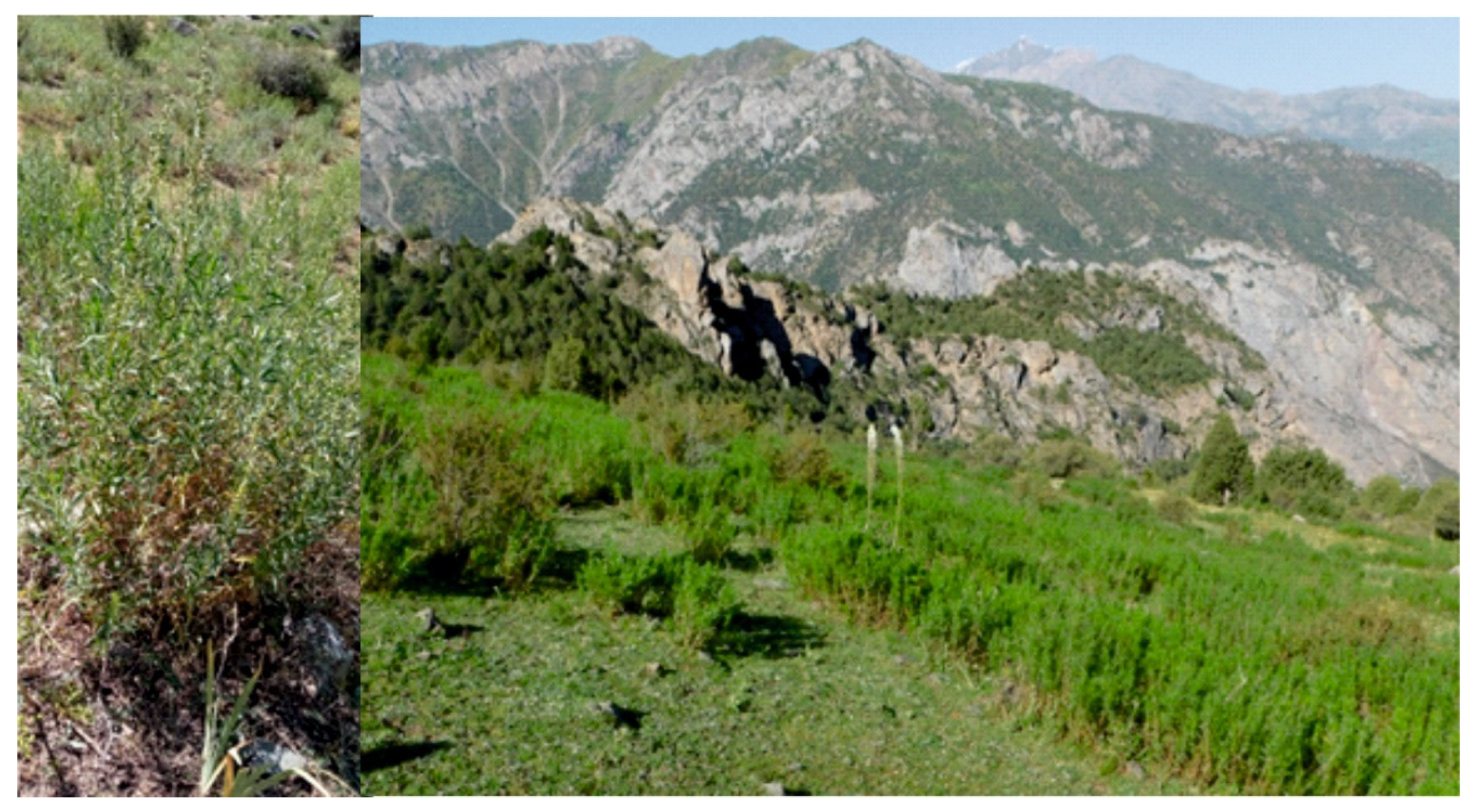
Figure 5.
Main land-use type in the Fann Mountains: (a) pasturelands on steep slopes, (b) pasturelands on terrain flattening, (c) residential areas and kitchen gardens/agricultural (irrigation) land (photo by M. Sobala—(a) 2019, (b) 2019 and O. Rahmonov—(c) 2004).
Figure 5.
Main land-use type in the Fann Mountains: (a) pasturelands on steep slopes, (b) pasturelands on terrain flattening, (c) residential areas and kitchen gardens/agricultural (irrigation) land (photo by M. Sobala—(a) 2019, (b) 2019 and O. Rahmonov—(c) 2004).

Figure 6.
The juniper forest occurs in the rare (a) or dense (b) form (photo by O. Rahmonov, 2023).

Figure 7.
Artemisia dracunculus—a common steppe element in the Fann Mountains (photo by O. Rahmonov, 2023).
Figure 7.
Artemisia dracunculus—a common steppe element in the Fann Mountains (photo by O. Rahmonov, 2023).

Figure 8.
The mobility of scree in the Fann Mountains determines the plant species occurrence (photo by M. Sobala, 2019).
Figure 8.
The mobility of scree in the Fann Mountains determines the plant species occurrence (photo by M. Sobala, 2019).

Figure 9.
Spatial changes in land use in the last 35 years: (A) state in 1988, (B) state in 2023; 1—villages, 2—peaks, 3—study area, 4—rivers, 5—artificial canals, 6—build-up areas, 7—kitchen gardens, 8—kolkhoz areas.
Figure 9.
Spatial changes in land use in the last 35 years: (A) state in 1988, (B) state in 2023; 1—villages, 2—peaks, 3—study area, 4—rivers, 5—artificial canals, 6—build-up areas, 7—kitchen gardens, 8—kolkhoz areas.

Figure 10.
Land use in the spring zone of the Uroz River (photo by O. Rahmonov). Photo from 2003 from the eastern direction. Photo from 2014 and 2023 from the southern direction.
Figure 10.
Land use in the spring zone of the Uroz River (photo by O. Rahmonov). Photo from 2003 from the eastern direction. Photo from 2014 and 2023 from the southern direction.

Figure 11.
Irrigation system in upper section of Urej river. (A)—typical fragment of anthropogenic canal; (B)—the net of irrigation ditches (IDs) (photo by O. Rahmonov, 2023).
Figure 11.
Irrigation system in upper section of Urej river. (A)—typical fragment of anthropogenic canal; (B)—the net of irrigation ditches (IDs) (photo by O. Rahmonov, 2023).

Figure 12.
Typical kitchen gardens in Artuch settlement (photo by O. Rahmonov, 2023).

Figure 13.
Soil creeping as result of irrigation (photo by O. Rahmonov, 2019).

Figure 14.
Landforms and objects typical of land cultivation and animal grazing in the Fann Mountains: (a) stone walls, (b) stone mounds, (c,d) animal terraces, (e) active stone enclosure for animals, (f) abandoned stone enclosure for animals (photo by M. Sobala, 2019).
Figure 14.
Landforms and objects typical of land cultivation and animal grazing in the Fann Mountains: (a) stone walls, (b) stone mounds, (c,d) animal terraces, (e) active stone enclosure for animals, (f) abandoned stone enclosure for animals (photo by M. Sobala, 2019).


Table 1.
Land cover and land use in Urej River catchment in 2023.
| No. | Land Cover Class | Area in km2 | Area in % | |
|---|---|---|---|---|
| 1 | Ticket of Ephedra equisetina, | pasturelands | 2.34 | 0.9 |
| 2 | Tickets of Berberis oblongata and Rosa fedtschenkoana, R. ecae | 0.45 | 0.2 | |
| 3 | Peat bogs | 0.65 | 0.2 | |
| 4 | Steppified farmland, pastureland after felling of junipers | 20.03 | 7.3 | |
| 5 | Alpine meadow/steppe vegetation | 48.56 | 17.8 | |
| 6 | Scattered and rarely forest with Juniperus seravschanica and J. semiglobosa | 59.81 | 21.9 | |
| 7 | Dense forms of Juniperus seravschanica and J. semoglobosa | 41.50 | 15.2 | |
| 8 | Rocky surface and scree with scarce vegetation | 36.83 | 13.5 | |
| 9 | Slopes, mountain ridges | 45.96 | 16.8 | |
| 10 | Build-up areas with kitchen garden | 4.83 | 1.8 | |
| 11 | Irrigated farmland | 10.88 | 4.0 | |
| 12 | Lakes | 1.48 | 0.5 | |
| Total: | 273.32 | 100.0 | ||
Table 2.
Selected land-use categories in Urej River catchment in 1988.
| No. | Land Cover Class | Area in km2 |
|---|---|---|
| 1 | Build-up areas | 0.96 |
| 2 | Kitchen gardens | 0.28 |
| 3 | Kolkhoz areas | 1.94 |
Disclaimer/Publisher’s Note: The statements, opinions and data contained in all publications are solely those of the individual author(s) and contributor(s) and not of MDPI and/or the editor(s). MDPI and/or the editor(s) disclaim responsibility for any injury to people or property resulting from any ideas, methods, instructions or products referred to in the content. |
© 2024 by the authors. Licensee MDPI, Basel, Switzerland. This article is an open access article distributed under the terms and conditions of the Creative Commons Attribution (CC BY) license (https://creativecommons.org/licenses/by/4.0/).
Share and Cite
MDPI and ACS Style
Rahmonov, O.; Szypuła, B.; Sobala, M.; Islamova, Z.B. Environmental and Land-Use Changes as a Consequence of Land Reform in the Urej River Catchment (Western Tajikistan). Resources 2024, 13, 59. https://doi.org/10.3390/resources13040059
AMA Style
Rahmonov O, Szypuła B, Sobala M, Islamova ZB. Environmental and Land-Use Changes as a Consequence of Land Reform in the Urej River Catchment (Western Tajikistan). Resources. 2024; 13(4):59. https://doi.org/10.3390/resources13040059
Chicago/Turabian StyleRahmonov, Oimahmad, Bartłomiej Szypuła, Michał Sobala, and Zebiniso B. Islamova. 2024. "Environmental and Land-Use Changes as a Consequence of Land Reform in the Urej River Catchment (Western Tajikistan)" Resources 13, no. 4: 59. https://doi.org/10.3390/resources13040059
Note that from the first issue of 2016, this journal uses article numbers instead of page numbers. See further details here.