| 1 | 2695540 | −64.70331 | 32.37339 | Bermuda Esso Pier, St. Georges Island | A |
| 2 | 8410140 | −66.98290 | 44.90460 | Eastport, Passamaquoddy Bay | A |
| 3 ** | 8410714 | −67.10840 | 44.87045 | Coffin Point, Coffin Neck | A |
| 4 ** | 8410715 | −67.13000 | 44.92330 | Garnet Point, Hersey Neck | A |
| 5 ** | 8410834 | −67.14375 | 45.12889 | Pettegrove Point, Dochet Island | A |
| 6 ** | 8410864 | −67.15167 | 44.82333 | Gravelly Pt., Whiting Bay | A |
| 7 | 8411060 | −67.20917 | 44.65637 | Cutler Farris Wharf, Little River | A |
| 8 | 8411250 | −67.29670 | 44.64170 | Cutler Naval Base, Machias Bay | A |
| 9 ** | 8412581 | −67.87500 | 44.54000 | Milbridge, Narraguagus River | A |
| 10 ** | 8413320 | −68.20500 | 44.39170 | Bar Harbor, Frenchman Bay | A |
| 11 | 8413825 | −68.43500 | 44.17000 | Mackerel Cove, Swans Island | A |
| 12 | 8414249 | −68.62093 | 44.19231 | Oceanville, Deer Island | A |
| 13 ** | 8414612 | −68.77190 | 44.78765 | Bangor, Penobscot River | A |
| 14 | 8414721 | −68.81330 | 44.47170 | Fort Point, Penobscot River | A |
| 15 | 8414888 | −68.88840 | 44.16080 | Pulpit Harbor, Penobscot Bay | A |
| 16 ** | 8415490 | −69.10170 | 44.10500 | Rockland | A |
| 17 ** | 8415709 | −69.18170 | 44.07136 | Thomaston, St George River | A |
| 18 | 8417177 | −69.78500 | 43.75500 | Hunniwell Point, Kennebec River | A |
| 19 ** | 8417208 | −69.79708 | 44.08721 | Richmond, Kennebec River | A |
| 20 ** | 8417227 | −69.80880 | 43.92500 | Bath, Kennebec River | A |
| 21 ** | 8418150 | −70.24601 | 43.65608 | Portland, Casco Bay | A |
| 22 * | 8418445 | −70.33330 | 43.54000 | Pine Point, Scarborough River | A |
| 23 * | 8418606 | −70.38170 | 43.46170 | Camp Ellis, Saco River | A |
| 24 * | 8419317 | −70.56303 | 43.31966 | Wells, Webhannet River | A |
| 25 ** | 8419870 | −70.74170 | 43.08000 | Seavey Island, Portsmouth Harbor | A |
| 26 ** | 8423898 | −70.71167 | 43.07179 | Fort Point, Newcastle Island | A |
| 27 ** | 8440273 | −70.90800 | 42.83600 | Salisbury Point, Merrimack River | A |
| 28 * | 8440452 | −70.82000 | 42.81670 | Plum Island, Merrimack River Ent. | A |
| 29 ** | 8440466 | −70.87330 | 42.81500 | Newburyport, Merrimack River | A |
| 30 * | 8441551 | −70.61507 | 42.66033 | Rockport Harbor | A |
| 31 ** | 8442645 | −70.87649 | 42.52295 | Salem, Salem Harbor | A |
| 32 ** | 8443187 | −70.94330 | 42.45830 | Lynn, Lynn Harbor | A |
| 33 ** | 8443970 | −71.04720 | 42.35750 | Boston, Boston Harbor | A |
| 34 | 8444162 | −70.89170 | 42.32830 | Boston Light, Boston Harbor | A |
| 35 ** | 8444525 | −70.95330 | 42.28000 | Nut Island, Quincy Bay | A |
| 36 ** | 8444788 | −70.96670 | 42.24830 | Shipyard Point, Weymouth Fore River | A |
| 37 | 8445138 | −70.72476 | 42.20099 | Scituate, Scituate Harbor | A |
| 38 | 8446009 | −70.63873 | 42.08330 | Brant Rock, Green Harbor River | A |
| 39 ** | 8446121 | −70.18216 | 42.04959 | Provincetown, Cape Cod | A |
| 40 ** | 8446166 | −70.66789 | 42.03830 | Duxbury, Duxbury Harbor | A |
| 41 * | 8446493 | −70.66170 | 41.96000 | Plymouth, Plymouth Harbor | A |
| 42 ** | 8447173 | −70.53500 | 41.77500 | Sagamore, Cape Cod Canal | A |
| 43 ** | 8447191 | −70.56170 | 41.77000 | Bournedale, Cape Cod Canal | A |
| 44 * | 8447241 | −70.15550 | 41.75600 | Sesuit Harbor, East Dennis | A |
| 45 ** | 8447259 | −70.59342 | 41.74585 | Bourne Bridge, Cape Cod Canal | A |
| 46 ** | 8447270 | −70.61670 | 41.74170 | Buzzards Bay, Cape Cod Canal | A |
| 47 ** | 8447295 | −70.62425 | 41.73500 | Gray Gables, Buzzards Bay | A |
| 48 | 8447368 | −70.71500 | 41.71170 | Great Hill | A |
| 49 ** | 8447386 | −71.16550 | 41.70580 | Fall River, Hope Bay | A |
| 50 | 8447416 | −70.71941 | 41.69578 | Piney Point, Wings Cove | A |
| 51 * | 8447435 | −69.94887 | 41.68847 | Chatham, Lydia Cove | A |
| 52 | 8447495 | −70.05670 | 41.66478 | Saquatucket Harbor | A |
| 53 | 8447712 | −70.89981 | 41.59292 | New Bedford, Clarks Point | A |
| 54 | 8447842 | −70.92830 | 41.53830 | Round Hill Point | A |
| 55 | 8447930 | −70.67170 | 41.52330 | Woods Hole, Buzzards Bay | A |
| 56 ** | 8448157 | −70.59870 | 41.45830 | Vineyard Haven, Vineyard Hvn Hbr | A |
| 57 ** | 8448558 | −70.51150 | 41.38822 | Edgartown, Martha’s Vineyard | A |
| 58 * | 8448725 | −70.76795 | 41.35461 | Menemsha Harbor | A |
| 59 ** | 8449130 | −70.09438 | 41.28503 | Nantucket Island, Nantucket Sound | A |
| 60 * | 8451552 | −71.25500 | 41.63670 | Bristol Ferry | A |
| 61 | 8452660 | −71.32670 | 41.50500 | Newport, Narragansett Bay | A |
| 62 | 8452944 | −71.34330 | 41.71670 | Conimicut Light, Narragansett Bay | A |
| 63 | 8453742 | −71.38670 | 41.49670 | West Jamestown | A |
| 64 ** | 8454000 | −71.39978 | 41.80786 | Providence, Providence River | A |
| 65 * | 8454049 | −71.41100 | 41.58680 | Quonset Point | A |
| 66 ** | 8454538 | −71.44346 | 41.57384 | Wickford, Narragansett Bay | A |
| 67 | 8455083 | −71.49000 | 41.36330 | Point Judith, Harbor Of Refuge | A |
| 68 | 8458022 | −71.76170 | 41.32830 | Weekapaug Point, Block Island Sound | A |
| 69 | 8459338 | −71.55621 | 41.17404 | Block Island Harbor, Old Harbor | A |
| 70 | 8459479 | −71.58000 | 41.22830 | Sandy Point, Block Island Sound | A |
| 71 | 8459681 | −71.61064 | 41.16330 | Block Island, Block Island Sound | A |
| 72 ** | 8461490 | −72.08975 | 41.36105 | New London, Thames River | A |
| 73 ** | 8463701 | −72.53170 | 41.26830 | Clinton, Clinton Harbor | A |
| 74 ** | 8465705 | −72.90830 | 41.28330 | New Haven, New Haven Harbor | A |
| 75 ** | 8467150 | −73.18170 | 41.17330 | Bridgeport, Bridgeport Harbor | A |
| 76 * | 8467373 | −73.21330 | 41.15670 | Black Rock Harbor, Cedar Creek | A |
| 77 ** | 8467726 | −73.28286 | 41.13249 | Southport, Southport Harbor | A |
| 78 | 8468799 | −73.48000 | 41.03830 | Long Neck Point, Long Island Sound | A |
| 79 | 8510321 | −71.85586 | 41.07199 | Montauk Point Light | A |
| 80 * | 8510448 | −71.93500 | 41.07330 | Lake Montauk (U.S.C.G.) | A |
| 81 ** | 8510560 | −71.96000 | 41.04830 | Montauk, Fort Pond Bay | A |
| 82 | 8510719 | −72.03191 | 41.25792 | Silver Eel Pond, Fishers Island | A |
| 83 * | 8511171 | −72.19000 | 41.03500 | Threemile Harbor Entrance | A |
| 84 | 8511236 | −72.20521 | 41.17125 | Plum Island Plum Gut Harbor | A |
| 85 | 8511671 | −72.30670 | 41.13670 | Orient, Orient Harbor | A |
| 86 | 8512668 | −72.56170 | 41.01500 | Mattituck Inlet, Long Island | A |
| 87 ** | 8512735 | −72.58170 | 40.93470 | South Jamesport, Great Peconic | A |
| 88 ** | 8512769 | −72.58667 | 40.81830 | Shinnecock Yacht Club, Penn. Creek | A |
| 89 * | 8512987 | −72.64500 | 40.98170 | Northville Fuel Dock, Long Island | A |
| 90 | 8513825 | −72.86830 | 40.73830 | Smith Point Bridge, Narrow Bay | A |
| 91 * | 8514322 | −73.00000 | 40.74780 | Patchogue, Patchogue River | A |
| 92 * | 8514422 | −73.04330 | 40.96500 | Cedar Beach | A |
| 93 ** | 8515586 | −73.35330 | 40.90000 | Northport, Northport Bay | A |
| 94 | 8515786 | −73.40000 | 40.95330 | Eatons Neck, Huntington Bay | A |
| 95 ** | 8515921 | −73.43170 | 40.91000 | Lloyd Harbor Lighthouse | A |
| 96 ** | 8516061 | −73.47000 | 40.87330 | Cold Springs Harbor | A |
| 97 ** | 8516299 | −73.55000 | 40.90330 | Bayville Bridge, Oyster Bay | A |
| 98 ** | 8516614 | −73.65500 | 40.86330 | Glen Cove Yacht Club, Long Island | A |
| 99 ** | 8516761 | −73.70330 | 40.83170 | Port Washington, Manhassset Bay | A |
| 100 * | 8516945 | −73.76490 | 40.81030 | Kings Point, Long Island Sound | A |
| 101 ** | 8516990 | −73.78170 | 40.79330 | Willets Point, Little Bay, East River | A |
| 102 ** | 8517276 | −73.85670 | 40.78330 | College Pt, Ft. Of 110Th St | A |
| 103 ** | 8517847 | −73.99517 | 40.70374 | Brooklyn Bridge, East River | A |
| 104 | 8518091 | −73.67170 | 40.96170 | Rye Beach, Amusement Park | A |
| 105 ** | 8518639 | −73.90625 | 40.80133 | Port Morris, East 138Th St. | A |
| 106 ** | 8518668 | −73.94170 | 40.77670 | Horns Hook, E. 90Th St. Hell Gate | A |
| 107 ** | 8518687 | −73.95830 | 40.75830 | Queensboro Bridge, East River | A |
| 108 ** | 8518699 | −73.96956 | 40.71170 | Williamsburg Bridge | A |
| 109 ** | 8518750 | −74.01436 | 40.70020 | The Battery, New York Harbor | A |
| 110 ** | 8518903 | −73.92500 | 40.87830 | Spuyten Duyvil Ck, Ent., Hudson R. | A |
| 111 ** | 8518905 | −73.91670 | 40.90330 | Riverdale, Hudson River | A |
| 112 ** | 8518924 | −73.96330 | 41.21830 | Haverstraw Bay | A |
| 113 ** | 8519483 | −74.14230 | 40.63980 | Bergen Point West, Kill Van Kull | A |
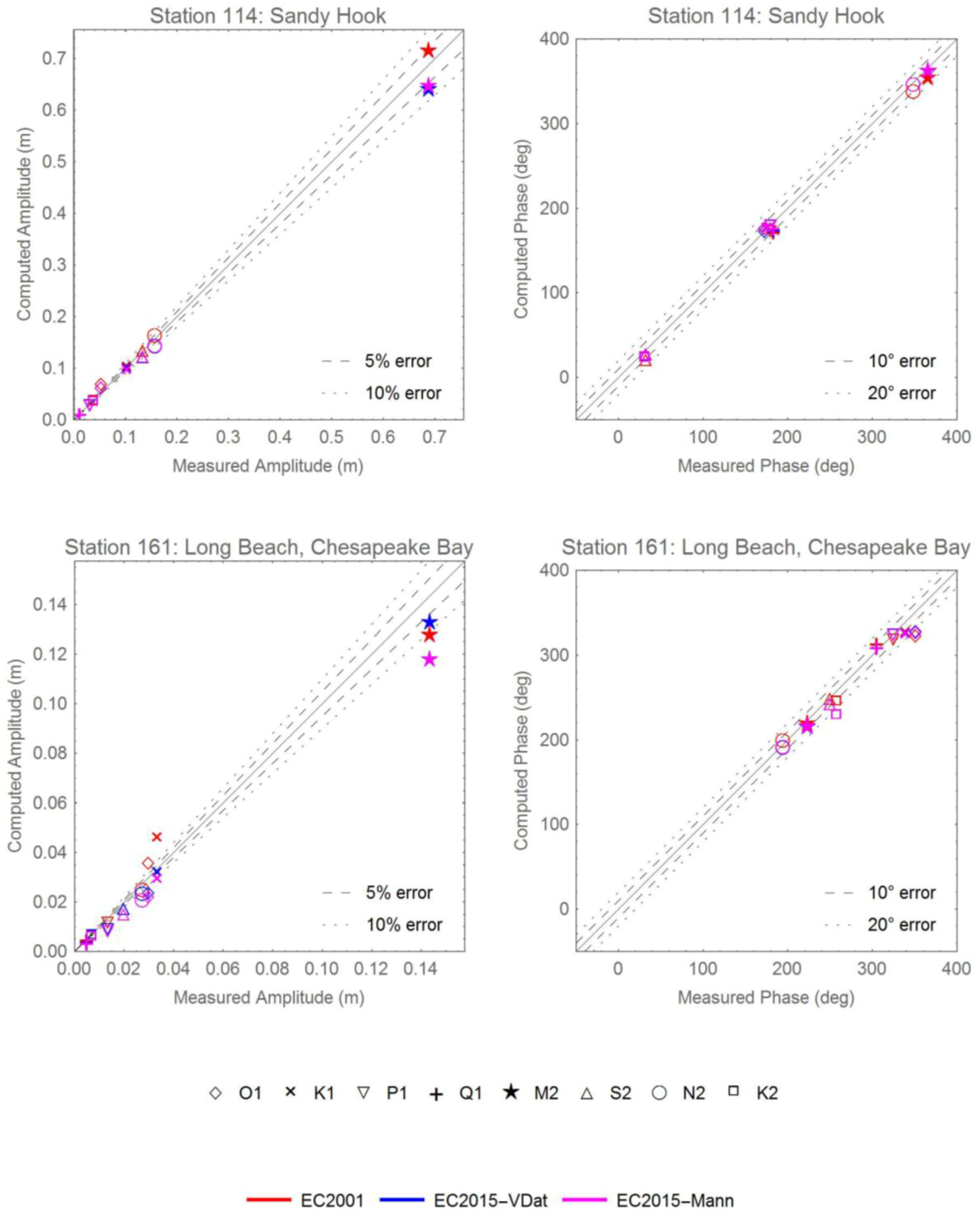
| 114 * | 8531680 | −74.00940 | 40.46690 | Sandy Hook | A |
| 115 | 8534720 | −74.41830 | 39.35500 | Atlantic City, Atlantic Ocean | A |
| 116 | 8534770 | −74.47670 | 39.33500 | Ventnor City, Fishing Pier | A |
| 117 * | 8534836 | −74.53330 | 39.30830 | Longport, Risely Channel | A |
| 118 * | 8536110 | −74.96000 | 38.96833 | Cape May Canal, Delaware Bay | A |
| 119 * | 8536581 | −74.89170 | 39.12830 | Bidwell Creek Entrance, Del. Bay | A |
| 120 * | 8536931 | −75.17500 | 39.23830 | Fortescue Creek | A |
| 121 | 8537121 | −75.37500 | 39.30500 | Ship John Shoal, Delaware River | A |
| 122 ** | 8538886 | −75.04300 | 40.01194 | Tacony-Palmyra Bridge | A |
| 123 ** | 8539094 | −74.86970 | 40.08170 | Burlington, Delaware River | A |
| 124 ** | 8539487 | −74.73670 | 40.13670 | Fieldsboro, Delaware River | A |
| 125 ** | 8539993 | −74.75500 | 40.18830 | Trenton Marine Terminal | A |
| 126 ** | 8540433 | −75.41000 | 39.81170 | Marcus Hook | A |
| 127 ** | 8545240 | −75.14091 | 39.93333 | Philadelphia (U.S.C.G.), Del. River | A |
| 128 ** | 8545530 | −75.13830 | 39.95330 | Philadelphia (Pier 11 North), Del. R | A |
| 129 ** | 8548989 | −74.75170 | 40.13670 | Newbold, Delaware River | A |
| 130 ** | 8551762 | −75.58830 | 39.58170 | Delaware City, Delaware River | A |
| 131 ** | 8551910 | −75.57331 | 39.55870 | Reedy Point, C&D Canal | A |
| 132 * | 8554399 | −75.40000 | 39.18500 | Mahon River Entrance, Del. Bay | A |
| 133 | 8555889 | −75.11333 | 38.98667 | Brandywine Shoal Light, Del. Bay | A |
| 134 * | 8557380 | −75.12000 | 38.78200 | Lewes, Ft. Miles | A |
| 135 * | 8558690 | −75.07000 | 38.61000 | Indian River Inlet | A |
| 136 | 8570280 | −75.08330 | 38.32670 | Ocean City, Fishing Pier | A |
| 137 ** | 8570283 | −75.09167 | 38.32833 | Ocean City Inlet | A |
| 138 ** | 8570536 | −75.18909 | 38.21516 | South Point, Chincoteague Bay | A |
| 139 ** | 8570649 | −75.28500 | 38.14830 | Public Landing, Chincoteague Bay | A |
| 140 ** | 8571091 | −75.86330 | 37.97670 | Crisfield | A |
| 141 | 8571117 | −76.02895 | 37.99826 | Ewell, Smith Island | A |
| 142 | 8571421 | −76.03830 | 38.22000 | Bishops Head, Hoopers Strait | A |
| 143 ** | 8571559 | −76.00500 | 38.30000 | Mccreadys Creek, Fishing Bay | A |
| 144 * | 8571579 | −76.26500 | 38.34170 | Barren Island, Chesapeake Bay | A |
| 145 ** | 8571773 | −75.81930 | 38.48396 | Vienna, Nanicoke River | A |
| 146 ** | 8571892 | −76.06818 | 38.57354 | Cambridge, Choptank River | A |
| 147 * | 8572467 | −76.37330 | 38.83670 | Kent Point, Chesapeake Bay | A |
| 148 ** | 8572669 | −75.94500 | 38.91670 | Hillsboro, Tuckahoe Creek | A |
| 149 * | 8572770 | −76.35500 | 38.95670 | Matapeake | A |
| 150 | 8572955 | −76.30110 | 39.03170 | Love Point Pier, Kent Island | A |
| 151 ** | 8573349 | −75.92500 | 39.24500 | Crumpton, Chester River | A |
| 152 * | 8573364 | −76.24577 | 39.21333 | Tolchester Beach, Chesapeake Bay | A |
| 153 * | 8573704 | −76.06330 | 39.37170 | Betterton, Sassafras River | A |
| 154 ** | 8573903 | −75.91670 | 39.50330 | Town Point Wharf | A |
| 155 ** | 8573927 | −75.81000 | 39.52766 | Chesapeake City | A |
| 156 * | 8574070 | −76.09000 | 39.53670 | Havre De Grace, Chesapeake Bay | A |
| 157 ** | 8574459 | −76.25500 | 39.38830 | Pond Point, Bush River | A |
| 158 ** | 8574680 | −76.57833 | 39.26667 | Baltimore (Fort McHenry) | A |
| 159 ** | 8574683 | −76.58500 | 39.26170 | Fort McHenry Marsh, Patapsco R | A |
| 160 ** | 8575512 | −76.48099 | 38.98441 | U.S. Naval Academy, Severn River | A |
| 161 | 8577004 | −76.47261 | 38.46579 | Long Beach, Chesapeake Bay | A |
| 162 * | 8577188 | −76.39640 | 38.39340 | Cove Point | A |
| 163 ** | 8577330 | −76.45167 | 38.31667 | Solomons Island, Patuxent River | A |
| 164 ** | 8579542 | −76.68333 | 38.65500 | Lower Marlboro, Patuxent River | A |
| 165 ** | 8579997 | −76.93923 | 38.93240 | Bladensburg, Anacostia River | A |
| 166 ** | 8594900 | −77.02167 | 38.87333 | Washington, Potomac River | A |
| 167 ** | 8630308 | −75.40516 | 37.90701 | Chincoteague Channel, South End | A |
| 168 | 8632200 | −75.98844 | 37.16519 | Kiptopeke, Chesapeake Bay | A |
| 169 * | 8632366 | −76.02450 | 37.26330 | Cape Charles Harbor (U.S.C.G.) | A |
| 170 | 8632837 | −76.01500 | 37.53830 | Rappahannock Light | A |
| 171 ** | 8632869 | −75.91670 | 37.55670 | Gaskins Pt., Occohannock Creek | A |
| 172 | 8633532 | −75.99288 | 37.82926 | Tangier Island, Chesapeake Bay | A |
| 173 | 8635150 | −76.96000 | 38.25170 | Colonial Beach, Potomac River | A |
| 174 ** | 8635257 | −77.24297 | 38.21330 | Rappahannock Bend | A |
| 175 ** | 8635750 | −76.46444 | 37.99590 | Lewisetta, Potomac River | A |
| 176 ** | 8635985 | −76.78330 | 37.87330 | Wares Wharf, Rappahannock R | A |
| 177 * | 8636580 | −76.29000 | 37.61442 | Windmill Point, Rappahannock R | A |
| 178 ** | 8636653 | −76.98996 | 37.58327 | Lester Manor | A |
| 179 * | 8637289 | −76.27330 | 37.34670 | New Point | A |
| 180 | 8637590 | −76.22170 | 37.25670 | New Point, Comfort Shoal | A |
| 181 ** | 8637624 | −76.50000 | 37.24670 | Gloucester Point, York River | A |
| 182 ** | 8637689 | −76.47833 | 37.22667 | Yorktown U.S.C.G. Training Center | A |
| 183 ** | 8638339 | −76.39911 | 36.82322 | Western Branch | A |
| 184 ** | 8638421 | −76.66830 | 37.05670 | Burwell Bay, James River | A |
| 185 ** | 8638424 | −76.66330 | 37.22000 | Kingsmill, James River | A |
| 186 ** | 8638433 | −76.78330 | 37.18500 | Scotland, James River | A |
| 187 ** | 8638445 | −76.91170 | 37.40330 | Lanexa, Chicahominy River | A |
| 188 ** | 8638450 | −76.94330 | 37.23988 | Tettington, James River | A |
| 189 ** | 8638489 | −77.37338 | 37.26686 | Puddledock, Appomattox River | A |
| 190 ** | 8638495 | −77.42060 | 37.52451 | Richmond River Locks, James River | A |
| 191 * | 8638610 | −76.33000 | 36.94667 | Sewells Point, Hampton Roads | A |
| 192 ** | 8638660 | −76.29202 | 36.82168 | Norfolk Naval Shipyard | A |
| 193 | 8638863 | −76.11333 | 36.96667 | Chesapeake Bay Bridge Tunnel | A |
| 194 | 8639207 | −75.96984 | 36.83180 | Inside Channel, Rudee Inlet | A |
| 195 ** | 8639348 | −76.30172 | 36.77804 | Money Point, S. Br. Elizabeth River | A |
| 196 | 8651370 | −75.74669 | 36.18331 | Duck, Frf Pier | A |
| 197 ** | 8652247 | −75.76890 | 35.90370 | Manns Harbor, Croatan Sound | A |
| 198 ** | 8652437 | −75.65645 | 35.84482 | Oyster Creek, Croatan Sound | A |
| 199 ** | 8652547 | −75.70000 | 35.81170 | Roanoke Marshes Light, Croatan S | A |
| 200 ** | 8652587 | −75.54936 | 35.79429 | Oregon Inlet Marina, Pamlico S | A |
| 201 | 8654400 | −75.63500 | 35.22330 | Cape Hatteras Fishing Pier | A |
| 202 ** | 8654467 | −75.70417 | 35.20950 | U.S.C.G. Hatteras, Pamlico S | A |
| 203 ** | 8654792 | −75.98945 | 35.11564 | Ocracoke Island | A |
| 204 ** | 8655875 | −76.34330 | 34.87500 | Sea Level, Core Sound | A |
| 205 ** | 8656483 | −76.67000 | 34.72000 | Beaufort, Duke Marine Lab | A |
| 206 | 8656590 | −76.71170 | 34.69330 | Atlantic Beach Triple S Pier | A |
| 207 ** | 8658120 | −77.95330 | 34.22670 | Wilmington, Cape Fear River | A |
| 208 | 8658163 | −77.78566 | 34.21330 | Wrightsville Beach | A |
| 209 ** | 8659084 | −78.01830 | 33.91500 | Southport | A |
| 210 | 8659182 | −78.08170 | 33.90170 | Oak Island, Atlantic Ocean | A |
| 211 * | 8659897 | −78.50670 | 33.86500 | Sunset Beach Pier, Atlantic Ocean | A |
| 212 | 8661070 | −78.91830 | 33.65500 | Springmaid Pier, Atlantic Ocean | A |
| 213 ** | 8664022 | −79.92138 | 33.00880 | Gen. Dynamics Pier, Cooper R. | A |
| 214 ** | 8664545 | −79.83000 | 32.92670 | Cainhoy, Wando River | A |
| 215 ** | 8664941 | −79.70670 | 32.85670 | South Capers Island, Capers Creek | A |
| 216 ** | 8665099 | −80.02170 | 32.83670 | I-526 Bridge, Ashley River | A |
| 217 ** | 8665530 | −79.92378 | 32.78170 | Charleston, Cooper River Entrance | A |
| 218 ** | 8667633 | −80.78410 | 32.50250 | Clarendon Plantation, Whale Br. | A |
| 219 ** | 8668498 | −80.46500 | 32.34000 | Hunting Island Pier, Fripps Inlet | A |
| 220 | 8668918 | −80.73670 | 32.26670 | Ribaut Island, Skull Creek | A |
| 221 ** | 8670870 | −80.90170 | 32.03373 | Fort Pulaski, Savannah River | A |
| 222 ** | 8677344 | −81.39670 | 31.13170 | St Simons Lighthouse | A |
| 223 ** | 8679511 | −81.51323 | 30.79781 | Kings Bay | A |
| 224 ** | 8679758 | −81.47170 | 30.76330 | Dungeness, Seacamp Dock | A |
| 225 ** | 8679964 | −81.54830 | 30.72000 | St. Marys, St. Marys River | A |
| 226 ** | 8720011 | −81.46500 | 30.70830 | Cut 1N, St Marys River Entr | A |
| 227 | 8720012 | −81.30170 | 30.71670 | Cut 2N, St Marys River Entr | A |
| 228 ** | 8720030 | −81.46539 | 30.67171 | Fernandina Beach, Amelia River | A |
| 229 ** | 8720051 | −81.52330 | 30.64330 | Lanceford Creek, Lofton | A |
| 230 ** | 8720098 | −81.51500 | 30.56830 | Nassauville, Nassau River East | A |
| 231 ** | 8720211 | −81.41330 | 30.40000 | Mayport (Naval Sta.) St Johns R | A |
| 232 ** | 8720218 | −81.43000 | 30.39670 | Bar Pilots Dock, St Johns River | A |
| 233 ** | 8720219 | −81.55830 | 30.38670 | Dames Point, St. Johns River | A |
| 234 ** | 8720220 | −81.43170 | 30.39330 | Mayport (Ferry) Saint Johns R | A |
| 235 ** | 8720225 | −81.63408 | 30.38337 | Phoenix Park | A |
| 236 ** | 8720242 | −81.62000 | 30.36000 | Longbranch, St Johns River | A |
| 237 * | 8720291 | −81.38670 | 30.28330 | Jacksonville Beach | A |
| 238 ** | 8720357 | −81.69164 | 30.19170 | I-295 Bridge, West End, St Johns R | A |
| 239 ** | 8720503 | −81.62830 | 29.97830 | Red Bay Point, St Johns River | A |
| 240 ** | 8720554 | −81.30000 | 29.91670 | Vilano Beach (ICWW) | A |
| 241 ** | 8720582 | −81.30670 | 29.86670 | State Road 312, Matanzas River | A |
| 242 | 8720587 | −81.26330 | 29.85670 | St. Augustine Beach, Atlantic | A |
| 243 ** | 8720625 | −81.54832 | 29.80165 | Racy Point, St Johns River | A |
| 244 ** | 8720651 | −81.25830 | 29.76830 | Crescent Beach, Matanzas River | A |
| 245 ** | 8720692 | −81.22786 | 29.70453 | State Road A1A Bridge | A |
| 246 ** | 8720757 | −81.20500 | 29.61500 | Bings Landing, Matanzas River | A |
| 247 ** | 8720767 | −81.68170 | 29.59500 | Buffalo Bluff, St. Johns River | A |
| 248 ** | 8720774 | −81.63170 | 29.64328 | Palatka, St. Johns River | A |
| 249 ** | 8720832 | −81.67520 | 29.47675 | Welaka, St. Johns River | A |
| 250 * | 8721020 | −81.00500 | 29.22830 | Daytona Beach (Ocean) | A |
| 251 ** | 8721604 | −80.59350 | 28.41580 | Trident Pier, Port Canaveral | A |
| 252 ** | 8721608 | −80.60152 | 28.40871 | Canaveral Harbor Entrance | A |
| 253 ** | 8722125 | −80.37170 | 27.63170 | Vero Beach, Indian River | A |
| 254 ** | 8722208 | −80.32500 | 27.47170 | North Beach Causeway, Indian R | A |
| 255 ** | 8722548 | −80.06670 | 26.84330 | Pga Boulevard Bridge, Palm Beach | A |
| 256 ** | 8722588 | −80.05096 | 26.77000 | Port Of W. Palm Beach, Lake Worth | A |
| 257 ** | 8722669 | −80.04670 | 26.61330 | Lake Worth (ICWW) | A |
| 258 | 8722670 | −80.03330 | 26.61170 | Lake Worth Pier, Atlantic Ocean | A |
| 259 * | 8723080 | −80.12000 | 25.90330 | Haulover Pier, N. Miami Beach | A |
| 260 | 8723170 | −80.13154 | 25.76830 | Miami Beach (City Pier) | A |
| 261 | 8723178 | −80.13000 | 25.76330 | Miami Beach, Government Cut | A |
| 262 | 8723214 | −80.16180 | 25.73140 | Virginia Key, Biscayne Bay | A |
| 263 * | 8723962 | −81.01670 | 24.71830 | Key Colony Beach | G |
| 264 * | 8723970 | −81.10500 | 24.71170 | Vaca Key, Florida Bay | G |
| 265 * | 8724580 | −81.80790 | 24.55570 | Key West | G |
| 266 | 8724635 | −81.87830 | 24.45330 | Sand Key Lighthouse | G |
| 267 | 8724671 | −81.92153 | 24.71828 | Smith Shoal Light, Fl | G |
| 268 | 8724698 | −82.92000 | 24.63170 | Loggerhead Key, Dry Tortugas | G |
| 269 * | 8725110 | −81.80750 | 26.13170 | Naples, Gulf Of Mexico | G |
| 270 ** | 8725520 | −81.87120 | 26.64770 | Fort Myers, Caloosahatchee River | G |
| 271 | 8726347 | −82.76000 | 27.60170 | Egmont Key, Tampa Bay | G |
| 272 | 8726364 | −82.72670 | 27.61500 | Mullet Key, Tampa Bay | G |
| 273 | 8726384 | −82.56210 | 27.63870 | Port Manatee, Tampa Bay | G |
| 274 | 8726520 | −82.62690 | 27.76060 | St. Petersburg, Tampa Bay | G |
| 275 * | 8726607 | −82.55376 | 27.85778 | Port Tampa, Old Tampa Bay | G |
| 276 ** | 8726667 | −82.42500 | 27.91333 | Csx Rockport, Mckay Bay Entrance | G |
| 277 | 8726724 | −82.83170 | 27.97830 | Clearwater Beach, Gulf Of Mexico | G |
| 278 ** | 8726738 | −82.68500 | 27.98830 | Safety Harbor, Old Tampa Bay | G |
| 279 ** | 8727235 | −82.63830 | 28.69170 | Johns Island, Chassahowitzka Bay | G |
| 280 ** | 8727274 | −82.63830 | 28.76170 | Mason Creek, Homosassa Bay | G |
| 281 ** | 8727277 | −82.69540 | 28.77170 | Tuckers Island, Homosassa River | G |
| 282 ** | 8727293 | −82.60330 | 28.80063 | Halls River Bridge, Halls River | G |
| 283 ** | 8727306 | −82.65830 | 28.82500 | Ozello | G |
| 284 ** | 8727328 | −82.66670 | 28.86330 | Ozello North | G |
| 285 | 8727333 | −82.72330 | 28.87000 | Mangrove Point, Crystal Bay | G |
| 286 ** | 8727336 | −82.63500 | 28.88170 | Dixie Bay | G |
| 287 ** | 8727348 | −82.63829 | 28.90505 | Twin Rivers Marina, Crystal River | G |
| 288 ** | 8727359 | −82.69170 | 28.92330 | Shell Island, Crystal River | G |
| 289 | 8727520 | −83.03170 | 29.13500 | Cedar Key, Gulf Of Mexico | G |
| 290 * | 8728229 | −84.29000 | 30.05870 | Shell Point, Walker Creek | G |
| 291 * | 8728360 | −84.51170 | 29.91500 | Turkey Point | G |
| 292 ** | 8728690 | −84.98138 | 29.72670 | Apalachicola, Apalachicola River | G |
| 293 ** | 8729108 | −85.66694 | 30.15228 | Panama City, St. Andrew Bay | G |
| 294 | 8729210 | −85.87830 | 30.21330 | Panama City Beach, Gulf Of Mexico | G |
| 295 ** | 8729501 | −86.49330 | 30.50330 | Valpariso, Boggy Bayou | G |
| 296 | 8729678 | −86.86500 | 30.37670 | Navarre Beach | G |
| 297 ** | 8729905 | −87.35670 | 30.41860 | Millview, Perdido Bay | G |
| 298 ** | 8729941 | −87.42881 | 30.38694 | Blue Angels Park, Perdido Bay | G |
| 299 ** | 8731439 | −87.68428 | 30.27982 | Gulf Shores, Icww | G |
| 300 * | 8733821 | −87.93453 | 30.48664 | Point Clear, Mobile Bay | G |
| 301 | 8735180 | −88.07500 | 30.25000 | Dauphin Island, Mobile Bay | G |
| 302 ** | 8735391 | −88.08800 | 30.56517 | SH 163 Bridge, Dog River | G |
| 303 ** | 8737048 | −88.04010 | 30.70830 | Mobile State Docks, Mobile River | G |
| 304 | 8741196 | −88.53330 | 30.34000 | Pascagoula Point, Miss. Sound | G |
| 305 * | 8742221 | −88.66670 | 30.23830 | Horn Island, Mississippi Sound | G |
| 306 ** | 8743281 | −88.79830 | 30.39170 | Ocean Springs | G |
| 307 ** | 8744117 | −88.90330 | 30.41175 | Biloxi, Bay Of Biloxi | G |
| 308 | 8745557 | −89.08170 | 30.36000 | Gulfport Harbor, Mississippi Sound | G |
| 309 | 8747437 | −89.32578 | 30.32639 | Bay Waveland Yacht, Bay St. Louis | G |
| 310 | 8747766 | −89.36670 | 30.28170 | Waveland, Mississippi Sound | G |
| 311 | 8760417 | −89.04447 | 29.20075 | Devon Energy Facility, North Pass | G |
| 312 | 8760551 | −89.14000 | 28.99000 | South Pass | G |
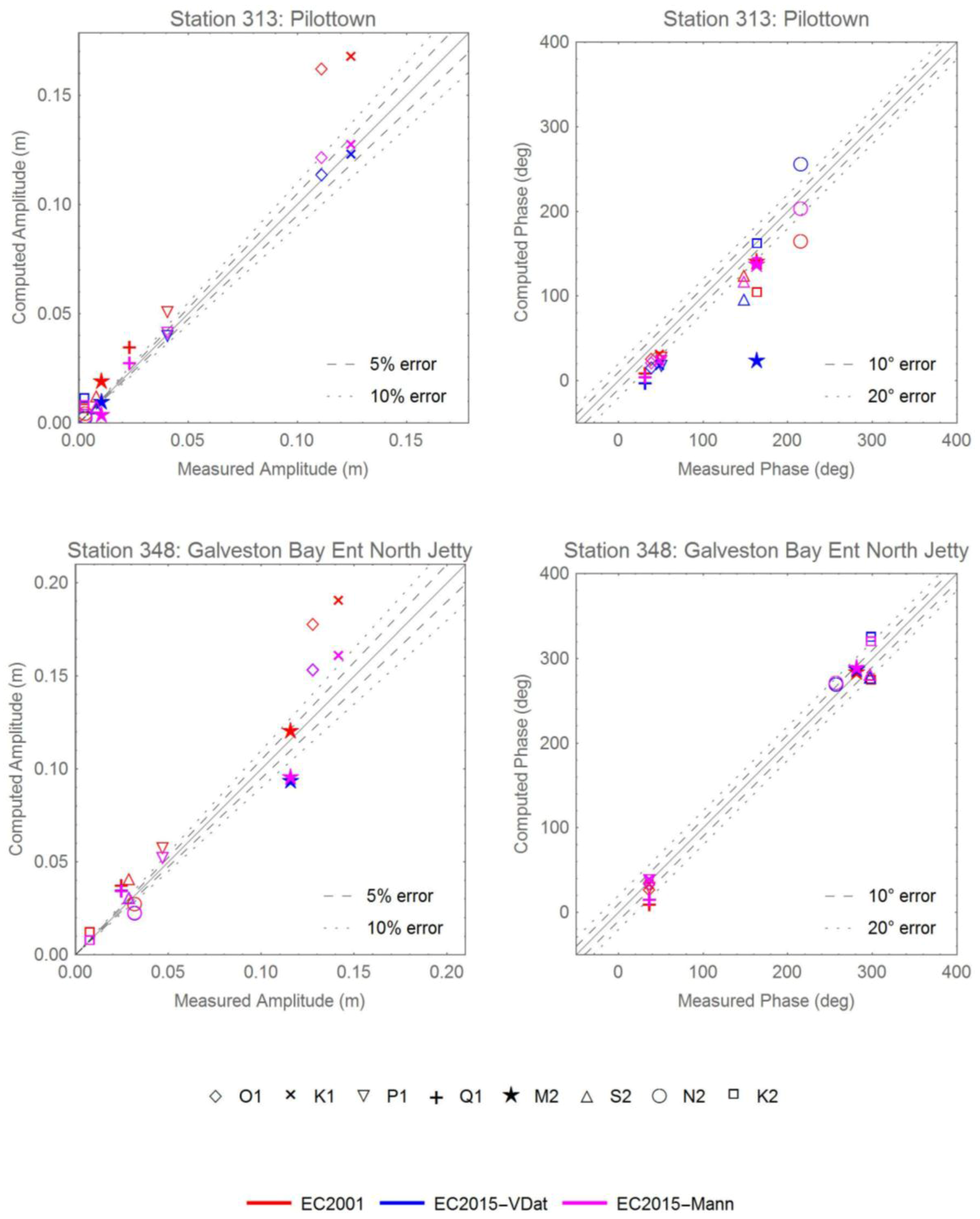
| 313 | 8760721 | −89.25830 | 29.17830 | Pilottown | G |
| 314 | 8760849 | −89.35120 | 29.27330 | Venice, Grand Pass | G |
| 315 | 8760922 | −89.40750 | 28.93220 | Pilot Station East, SW Pass | G |
| 316 | 8760943 | −89.41830 | 28.92500 | Pilot Station, SW Pass | G |
| 317 * | 8761305 | −89.67325 | 29.86811 | Shell Beach, Lake Borgne | G |
| 318 * | 8761529 | −89.83500 | 29.94500 | Martello Castle, Lake Borgne | G |
| 319 | 8761819 | −90.03830 | 29.40170 | Texaco Dock, Hackberry Bay | G |
| 320 * | 8761927 | −90.11342 | 30.02717 | U.S.C.G. New Canal, Lake Pont. | G |
| 321 ** | 8762075 | −90.20860 | 29.11430 | Port Fourchon, Belle Pass | G |
| 322 | 8763535 | −90.97600 | 29.17390 | Texas Gas Platform, Caillou Bay | G |
| 323 ** | 8764025 | −91.23000 | 29.74330 | Stouts Pass At Six Mile Lake | G |
| 324 ** | 8764044 | −91.23750 | 29.66750 | Berwick, Atchafalaya River, La | G |
| 325 | 8764227 | −91.33810 | 29.45500 | Lawma, Amerada Pass | G |
| 326 | 8764311 | −91.38500 | 29.37170 | Eugene Island | G |
| 327 | 8765251 | −91.88000 | 29.71336 | Cypremort Point | G |
| 328 * | 8767816 | −93.22167 | 30.22364 | Lake Charles, Calcasieu River | G |
| 329 | 8767961 | −93.30069 | 30.19031 | Bulk Terminal #1 | G |
| 330 | 8768094 | −93.34289 | 29.76817 | Calcasieu Pass, East Jetty | G |
| 331 ** | 8770475 | −93.93130 | 29.86670 | Port Arthur, Sabine Naches Canal | G |
| 332 ** | 8770520 | −93.88170 | 29.98000 | Rainbow Bridge, Neches River | G |
| 333 ** | 8770539 | −93.89500 | 29.76670 | Mesquite Point | G |
| 334 ** | 8770559 | −94.69040 | 29.71330 | Round Point, Trinity Bay | G |
| 335 ** | 8770570 | −93.87010 | 29.72840 | Sabine Pass North | G |
| 336 ** | 8770597 | −93.72170 | 30.09830 | Orange (Old Navy Base) | G |
| 337 ** | 8770613 | −94.98500 | 29.68170 | Morgans Point, Barbours Cut | G |
| 338 ** | 8770625 | −94.86830 | 29.68000 | Umbrella Point, Trinity Bay | G |
| 339 ** | 8770733 | −95.07830 | 29.76500 | Lynchburg Landing, San Jacinto R | G |
| 340 ** | 8770743 | −95.09000 | 29.75670 | Battleship Texas, Houston Ship Ch | G |
| 341 ** | 8770777 | −95.26580 | 29.72580 | Manchester, Houston Ship Ch | G |
| 342 | 8770822 | −93.83694 | 29.67806 | Texas Point, Sabine Pass | G |
| 343 ** | 8770933 | −95.06670 | 29.56330 | Clear Lake | G |
| 344 ** | 8770971 | −94.51330 | 29.51500 | Rollover Pass | G |
| 345 ** | 8771013 | −94.91830 | 29.48000 | Eagle Point, Galveston Bay | G |
| 346 | 8771081 | −93.64000 | 29.49830 | Sabine Offshore | G |
| 347 ** | 8771328 | −94.78000 | 29.36500 | Port Bolivar, Bolivar Roads | G |
| 348 | 8771341 | −94.72483 | 29.35733 | Galveston Bay Ent North Jetty | G |
| 349 ** | 8771450 | −94.79330 | 29.31000 | Galveston Pier 21 | G |
| 350 | 8771510 | −94.78940 | 29.28530 | Galveston Pleasure Pier, GoMex | G |
| 351 ** | 8772440 | −95.30830 | 28.94830 | Freeport, Dow Barge Canal | G |
| 352 ** | 8772447 | −95.30250 | 28.94310 | U.S.C.G. Freeport, Entr Channel | G |
| 353 ** | 8773037 | −96.71170 | 28.40800 | Seadrift, San Antonio Bay | G |
| 354 ** | 8773259 | −96.59500 | 28.64000 | Port Lavaca, Lavaca Causeway | G |
| 355 ** | 8773701 | −96.38830 | 28.45170 | Port O’Connor, Matagorda Bay | G |
| 356 ** | 8774513 | −97.02170 | 28.11830 | Copano Bay State Fishing Pier | G |
| 357 ** | 8774770 | −97.04670 | 28.02170 | Rockport, Aransas Bay | G |
| 358 ** | 8775188 | −97.47500 | 27.85830 | White Point Bay | G |
| 359 ** | 8775237 | −97.07330 | 27.83890 | Port Aransas | G |
| 360 | 8775270 | −97.05000 | 27.82670 | Port Aransas, H. Caldwell Pier | G |
| 361 ** | 8775283 | −97.20330 | 27.82130 | Port Ingleside, Corpus Christi Bay | G |
| 362 ** | 8775296 | −97.39000 | 27.81170 | Texas State Aquarium, Corpus | G |
| 363 ** | 8775421 | −97.28000 | 27.70500 | Corpus Christi Naval Air Station | G |
| 364 ** | 8775792 | −97.23670 | 27.63330 | Packery Channel | G |
| 365 | 8775870 | −97.21670 | 27.58000 | Corpus Christi, Gulf Of Mexico | G |
| 366 ** | 8779748 | −97.17670 | 26.07670 | South Padre Island (U.S.C.G) | G |
| 367 | 8779750 | −97.15670 | 26.06830 | Padre Island, Brazos Santiago Pass | G |
| 368 ** | 8779770 | −97.21500 | 26.06000 | Port Isabel, Laguna Madre | G |
| 369 | 9500966 | −97.78050 | 22.26200 | Madero, Tampico Harbor, Mexico | G |
| 370 | 9650593 | −87.87000 | 15.89300 | Puerto Cortes | C |
| 371 | 9710441 | −78.99700 | 26.71000 | Settlement Point, Grand Bahamas | C |
| 372 | 9751309 | −64.72100 | 18.36800 | Leinster Point (Bay), St. John | C |
| 373 * | 9751364 | −64.70500 | 17.75000 | Christiansted, St. Croix Island | C |
| 374 ** | 9751373 | −64.71480 | 18.34560 | St John’S Island, Coral Harbor | C |
| 375 ** | 9751381 | −64.72400 | 18.31800 | Lameshur Bay, St. John | C |
| 376 | 9751401 | −64.75410 | 17.69500 | Lime Tree Bay, St Croix | C |
| 377 | 9751467 | −64.80400 | 18.36090 | Lovango Cay, St John | C |
| 378 | 9751494 | −64.81800 | 18.29700 | Dog Island, St Thomas | C |
| 379 ** | 9751567 | −64.86905 | 18.31870 | Benner Bay | C |
| 380 | 9751583 | −64.86400 | 18.34870 | Water Bay, Saint Thomas | C |
| 381 * | 9751584 | −64.88400 | 17.71300 | Fredericksted, St. Croix Island | C |
| 382 ** | 9751639 | −64.92030 | 18.33570 | Charlotte Amalie, St. Thomas | C |
| 383 * | 9751768 | −64.96270 | 18.37110 | Ruy Point, St Thomas | C |
| 384 * | 9751774 | −65.03500 | 18.36300 | Botany Bay, St Thomas | C |
| 385 | 9752235 | −65.30200 | 18.30100 | Culebra | C |
| 386 | 9752619 | −65.44400 | 18.15300 | Isabel Segunda, Vieques Island | C |
| 387 * | 9752695 | −65.47100 | 18.09395 | Esperanza, Vieques Island | C |
| 388 | 9752962 | −65.57000 | 18.34500 | Isla Palominos | C |
| 389 * | 9753216 | −65.63100 | 18.33500 | Playa De Fajardo | C |
| 390 * | 9753641 | −65.71102 | 18.18700 | Naguabo | C |
| 391 * | 9754228 | −65.83300 | 18.05500 | Yabucoa Harbor | C |
| 392 ** | 9755371 | −66.11600 | 18.45900 | San Juan, La Puntilla, San Juan Bay | C |
| 393 | 9755679 | −66.15800 | 17.92800 | Las Mareas | C |
| 394 * | 9756639 | −66.40700 | 17.95390 | Santa Isabel | C |
| 395 | 9757809 | −66.70210 | 18.48140 | Arecibo, Puerto Rico | C |
| 396 | 9758053 | −66.76200 | 17.97300 | Penuelas, Punta Guayanilla | C |
| 397 ** | 9759110 | −67.04603 | 17.97000 | Magueyes Island | C |
| 398 ** | 9759189 | −67.18900 | 18.07500 | Puerto Real | C |
| 399 ** | 9759197 | −67.19700 | 17.95100 | Bahia Salinas | C |
| 400 * | 9759394 | −67.16080 | 18.21790 | Mayaguez, Puerto Rico | C |
| 401 | 9759412 | −67.16500 | 18.45700 | Aguadilla, Crashboat Beach | C |
| 402 | 9759421 | −67.18530 | 18.16500 | Punta Guanajabo, Mayagues | C |
| 403 | 9759938 | −67.93900 | 18.09000 | Mona Island | C |
| 404 * | 9761115 | −61.82100 | 17.59040 | Barbuda | C |
| 405 | IHO | −66.05000 | 45.23330 | Partridge Island | A |
| 406 | IHO | −67.04999 | 45.06667 | St Andrews | A |
| 407 | IHO | −66.86667 | 45.04583 | Back Bay | A |
| 408 | IHO | −65.06665 | 45.05000 | Margretsville | A |
| 409 | IHO | −67.01711 | 44.96622 | Fairhaven | A |
| 410 | IHO | −66.98333 | 44.90000 | Eastport | A |
| 411 | IHO | −66.95354 | 44.88334 | Welshpool | A |
| 412 | IHO | −62.75896 | 44.77344 | Murphy Cove | A |
| 413 ** | IHO | −66.75010 | 44.76557 | North Head | A |
| 414 | IHO | −65.83334 | 44.66667 | Deep Cove | A |
| 415 | IHO | −63.56712 | 44.64378 | Halifax | A |
| 416 | IHO | −66.79999 | 44.60000 | Outer Wood Island | A |
| 417 | IHO | −63.95001 | 44.49900 | Indian Harbour | A |
| 418 ** | IHO | −66.10001 | 44.46390 | Sandy Cove | A |
| 419 ** | IHO | −68.20001 | 44.40000 | Bar Harbour | A |
| 420 | IHO | −68.01666 | 44.40000 | Prospect Harbour | A |
| 421 | IHO | −66.39999 | 44.25000 | Lighthouse Cove | A |
| 422 | IHO | −66.16666 | 44.20000 | Meteghan | A |
| 423 | IHO | −68.88333 | 44.14642 | Pulpit Harbour | A |
| 424 | IHO | −64.66210 | 43.98320 | Liverpool | A |
| 425 | IHO | −65.10420 | 43.66480 | Lockeport | A |
| 426 ** | IHO | −70.24667 | 43.65667 | Portland | A |
| 427 | IHO | −65.74290 | 43.52580 | Woods Harbour | A |
| 428 | IHO | −66.00000 | 43.50000 | Flat Island | A |
| 429 | IHO | −66.00000 | 43.48333 | Seal Island | A |
| 430 ** | IHO | −70.74167 | 43.08000 | Portsmouth (Navy Yard) | A |
| 431 | IHO | −63.20001 | 42.81667 | Fundy 1 | A/D |
| 432 | IHO | −63.98334 | 42.78333 | SB2 | A/D |
| 433 | IHO | −64.36667 | 42.61666 | Fundy 21 | A/D |
| 434 | IHO | −67.71667 | 42.46667 | Fundy 6 | A/D |
| 435 ** | IHO | −71.03326 | 42.35078 | Boston (Commonwealth Piers) | A |
| 436 | IHO | −65.50000 | 42.11666 | Fundy 22a | A/D |
| 437 | IHO | −65.63333 | 42.05000 | Fundy 22b | A/D |
| 438 ** | IHO | −71.39694 | 41.80080 | Providence | A |
| 439 * | IHO | −70.50000 | 41.77482 | E Cape Cod Canal | A |
| 440 ** | IHO | −70.61667 | 41.74072 | WCape Cod Canal | A |
| 441 ** | IHO | −70.62512 | 41.73333 | Buzzards Bay | A |
| 442 | IHO | −65.79999 | 41.73333 | Fundy 3 | A/D |
| 443 * | IHO | −70.89999 | 41.60000 | New Bedford | A |
| 444 | IHO | −71.33334 | 41.50000 | Newport | A |
| 445 | IHO | −70.67143 | 41.52422 | Woods Hole (Ocean Inst) | A |
| 446 ** | IHO | −72.09900 | 41.34903 | New London | A |
| 447 | IHO | −72.35001 | 41.26667 | Connecticut River Ent | A |
| 448 * | IHO | −73.16666 | 41.16667 | Bridgeport | A |
| 449 | IHO | −72.20001 | 41.16521 | Plum Island | A |
| 450 * | IHO | −71.96667 | 41.05000 | montauk | A |
| 451 ** | IHO | −73.06728 | 40.95027 | Port Jefferson | A |
| 452 * | IHO | −73.78333 | 40.80000 | Willets Point | A |
| 453 ** | IHO | −73.85006 | 40.78285 | College Point | A |
| 454 | IHO | −66.83334 | 40.73333 | Fundy 4 | A/D |
| 455 ** | IHO | −73.23280 | 40.71533 | Bayshore Long Island | A |
| 456 ** | IHO | −74.01666 | 40.70000 | New York: Battery | A |
| 457 ** | IHO | −74.01666 | 40.68333 | New York: Governor’s Island | A |
| 458 | IHO | −74.03333 | 40.60000 | New York: Fort Hamilton | A |
| 459 | IHO | −74.01666 | 40.46833 | Sandy Hook | A |
| 460 | IHO | −67.75000 | 40.36666 | Fundy 23 | A/D |
| 461 | IHO | −70.89999 | 40.30000 | IAPSO: 30-1.2.32 | A/D |
| 462 | IHO | −68.63333 | 40.11667 | IAPSO: 30-1.2.1 | A/D |
| 463 ** | IHO | −75.13333 | 39.95000 | Philadelphia | A |
| 464 | IHO | −71.38333 | 39.95000 | IAPSO: 30-1.2.2 | A/D |
| 465 ** | IHO | −75.58334 | 39.58333 | Delaware City | A |
| 466 ** | IHO | −75.56665 | 39.55000 | Reedy Point | A |
| 467 ** | IHO | −75.81665 | 39.53140 | Chesapeake City | A |
| 468 ** | IHO | −75.88333 | 39.51667 | Court House Point | A |
| 469 ** | IHO | −75.98419 | 39.43576 | Elk River Entrance | A |
| 470 | IHO | −76.26666 | 39.28333 | Pooles Island Light | A |
| 471 ** | IHO | −76.58070 | 39.26940 | Baltimore | A |
| 472 | IHO | −72.16666 | 39.21667 | IAPSO: 30-1.2.17 | A/D |
| 473 | IHO | −71.36667 | 39.16667 | IAPSO: 30-1.2.19 | A/D |
| 474 | IHO | −76.41666 | 39.15000 | Seven Foot Knoll Light | A |
| 475 | IHO | −76.30221 | 39.04201 | Love Point Light | A |
| 476 ** | IHO | −76.48191 | 38.98550 | Annapolis | A |
| 477 * | IHO | −74.96000 | 38.96833 | Cape May Ferry Terminal | A |
| 478 | IHO | −76.43335 | 38.90000 | Thomas Point Shoal Light | A |
| 479 ** | IHO | −77.01725 | 38.86094 | Washington D.C. | A |
| 480 ** | IHO | −75.10220 | 38.78790 | Breakwater Harbour | A |
| 481 ** | IHO | −75.07045 | 38.60092 | Indian River Inlet | A |
| 482 ** | IHO | −76.06341 | 38.57254 | Cambridge | A |
| 483 ** | IHO | −76.45001 | 38.31667 | Solomons Island | A |
| 484 ** | IHO | −76.41666 | 38.31667 | Drum Point Light | A |
| 485 | IHO | −76.95001 | 38.25000 | Colonial Beach | A |
| 486 | IHO | −76.75000 | 38.21667 | Colton Point | A |
| 487 | IHO | −76.53333 | 38.13334 | Piney Point | A |
| 488 | IHO | −76.10001 | 38.06667 | Holland Island Bar Light | A |
| 489 | IHO | −76.26666 | 37.80000 | Great Wicomico Light | A |
| 490 | IHO | −76.26666 | 37.56667 | Stingray Point Light | A |
| 491 | IHO | −73.08334 | 37.36666 | IAPSO: 30-1.2.16 | A/D |
| 492 ** | IHO | −77.26666 | 37.31667 | City Point Hopewell | A |
| 493 ** | IHO | −76.02449 | 37.26667 | Cape Charles | A |
| 494 ** | IHO | −76.49882 | 37.24811 | Gloucester Point | A |
| 495 | IHO | −76.29999 | 37.00000 | Old Point Comfort | A |
| 496 ** | IHO | −76.33334 | 36.95000 | Hampton Roads (Sewall Pt.) | A |
| 497 | IHO | −75.96667 | 36.83333 | Virginia Beach | A |
| 498 | IHO | −75.50000 | 35.33333 | Avon | A |
| 499 * | IHO | −76.68335 | 34.71667 | Morehead City | A |
| 500 ** | IHO | −77.95001 | 34.23333 | Wilmington | A |
| 501 * | IHO | −78.01667 | 33.91500 | Southport | A |
| 502 | IHO | −78.89999 | 33.66667 | Myrtle Beach | A |
| 503 ** | IHO | −79.91666 | 32.78333 | Charleston | A |
| 504 | IHO | −75.61667 | 32.68333 | IAPSO: 30-1.2.3 | A/D |
| 505 | IHO | −64.64999 | 32.36666 | St. Davids Island | A |
| 506 ** | IHO | −80.78279 | 32.31757 | Port Royal Sound | A |
| 507 | IHO | −64.83334 | 32.31667 | Ireland Island | A |
| 508 ** | IHO | −80.89995 | 32.03360 | Savannah River Entrance | A |
| 509 | IHO | −64.43335 | 32.01667 | IAPSO: 30-1.2.18 | A/D |
| 510 ** | IHO | −81.20050 | 31.53659 | Sapelo Sound | A |
| 511 ** | IHO | −88.04010 | 30.70830 | Mobile | G |
| 512 | IHO | −76.41666 | 30.43333 | IAPSO: 30-1.2.11 | A/D |
| 513 ** | IHO | −88.90330 | 30.41175 | Biloxi | G |
| 514 ** | IHO | −87.21667 | 30.40000 | Pensacola | G |
| 515 * | IHO | −81.43259 | 30.39928 | Mayport | A |
| 516 ** | IHO | −87.26428 | 30.34872 | Warrington Navy Yard | G |
| 517 ** | IHO | −81.61667 | 30.35000 | Jacksonville Dredger Dept. | A |
| 518 | IHO | −90.29999 | 30.29805 | Pass Nanchac Light | G |
| 519 | IHO | −89.33334 | 30.30000 | Bay St Louis | G |
| 520 | IHO | −89.16666 | 30.23333 | Cat Island | G |
| 521 ** | IHO | −88.01666 | 30.23333 | Mobile Point Light | G |
| 522 ** | IHO | −85.74736 | 30.16939 | Alligator Bayou | G |
| 523 | IHO | −84.18335 | 30.06667 | St Marks Light | G |
| 524 | IHO | −90.11667 | 30.02376 | West End | G |
| 525 ** | IHO | −90.06803 | 29.91999 | New Orleans | G |
| 526 | IHO | −93.34736 | 29.78333 | Calcasieu Pass Light | G |
| 527 ** | IHO | −94.69040 | 29.71333 | Round Point | G |
| 528 | IHO | −84.98334 | 29.71667 | Apalachicola | G |
| 529 | IHO | −93.85001 | 29.70000 | Sabine | G |
| 530 ** | IHO | −94.98334 | 29.68333 | Morgan Point | G |
| 531 * | IHO | −94.49038 | 29.51828 | Gilchrist | G |
| 532 | IHO | −92.03492 | 29.57862 | Lighthouse Point | G |
| 533 ** | IHO | −91.54999 | 29.51667 | Point Chevreuil | G |
| 534 | IHO | −91.76710 | 29.48820 | South Point | G |
| 535 | IHO | −89.16666 | 29.48333 | Breton Island | G |
| 536 ** | IHO | −91.27077 | 29.51204 | Shell Island | G |
| 537 | IHO | −91.59734 | 29.50966 | Rabbit Island Pass | G |
| 538 | IHO | −91.38500 | 29.37170 | Eugene Island | G |
| 539 ** | IHO | −89.33334 | 29.36667 | Jack Bay | G |
| 540 | IHO | −94.70001 | 29.33333 | Galveston Bay Entrance | G |
| 541 | IHO | −91.75000 | 29.28667 | Point au Fer | G |
| 542 ** | IHO | −94.78333 | 29.31667 | Galveston | G |
| 543 ** | IHO | −89.96667 | 29.26667 | Bayou Rigaud | G |
| 544 | IHO | −89.60001 | 29.25000 | Empire Jetty | G |
| 545 | IHO | −81.00000 | 29.23333 | Daytona Beach | A |
| 546 ** | IHO | −95.00000 | 29.21667 | Carancahua Reef | G |
| 547 | IHO | −89.04999 | 29.21667 | Lonesome Bayou | G |
| 548 ** | IHO | −81.00000 | 29.21667 | Daytona Beach | A |
| 549 | IHO | −83.03167 | 29.13333 | Cedar Kay | G |
| 550 | IHO | −89.03333 | 29.11667 | Southeast Pass | G |
| 551 | IHO | −89.26666 | 29.05000 | Joseph Bayou | G |
| 552 | IHO | −89.16666 | 29.01667 | Port Eads | G |
| 553 | IHO | −89.13333 | 28.98333 | South Pass | G |
| 554 | IHO | −95.29999 | 28.93333 | Freeport | G |
| 555 | IHO | −89.42833 | 28.93167 | Southwest Pass | G |
| 556 * | IHO | −82.66874 | 28.45132 | Indian Bay | G |
| 557 | IHO | −76.79999 | 28.45000 | IAPSO: 30-1.2.15 | A/D |
| 558 | IHO | −67.53333 | 28.23333 | IAPSO: 30-1.2.5 | A/D |
| 559 | IHO | −69.75000 | 28.13333 | IAPSO: 30-1.2.4 | A/D |
| 560 ** | IHO | −97.04999 | 28.01667 | Rockport | G |
| 561 | IHO | −76.78333 | 28.01667 | IAPSO: 30-1.2.14 | A/D |
| 562 | IHO | −69.66666 | 27.98333 | IAPSO: 30-1.2.8 | A/D |
| 563 | IHO | −69.66666 | 27.96667 | IAPSO: 30-1.2.7 | A/D |
| 564 ** | IHO | −97.39999 | 27.81493 | Nueces Bay | G |
| 565 | IHO | −82.61667 | 27.76667 | St Petersburg | G |
| 566 * | IHO | −82.73295 | 27.53391 | Anna Maria | G |
| 567 ** | IHO | −82.25000 | 26.71667 | South Boca Grande | G |
| 568 | IHO | −84.25000 | 26.70000 | IAPSO: 30-1.2.13 | G/D |
| 569 ** | IHO | −81.86667 | 26.65000 | Fort Myers | G |
| 570 ** | IHO | −82.06665 | 26.63333 | Matlacha Pass | G |
| 571 ** | IHO | −82.08081 | 26.55000 | Tropical Homesites | G |
| 572 ** | IHO | −82.18335 | 26.51667 | Captiva Island | G |
| 573 ** | IHO | −82.08334 | 26.48333 | St James City | G |
| 574 ** | IHO | −82.01666 | 26.48333 | Punta Rassa | G |
| 575 | IHO | −69.33334 | 26.46667 | IAPSO: 30-1.2.13 | A/D |
| 576 ** | IHO | −81.95001 | 26.45511 | Matanzas Pass | G |
| 577 ** | IHO | −81.93335 | 26.45000 | Hurricane Bay San Carlos | G |
| 578 | IHO | −69.31665 | 26.45000 | IAPSO: 30-1.2.9 | A/D |
| 579 ** | IHO | −81.90951 | 26.43333 | Estero Island Estero Bay | G |
| 580 ** | IHO | −81.85938 | 26.43120 | Mound Key Estero Bay | G |
| 581 ** | IHO | −81.89248 | 26.41690 | Ostego Bay | G |
| 582 ** | IHO | −81.88324 | 26.40748 | Carlos Point Estero Bay | G |
| 583 ** | IHO | −97.35001 | 26.35000 | North Point | G |
| 584 ** | IHO | −97.21500 | 26.06000 | Port Isabel | G |
| 585 | IHO | −97.14999 | 26.06667 | South Padre Island | G |
| 586 | IHO | −79.89999 | 25.85000 | IAPSO: 30-1.2.12 | A/D |
| 587 | IHO | −79.28333 | 25.55000 | Cat Cay | A |
| 588 | IHO | −77.35001 | 25.08333 | Nassau | A |
| 589 | IHO | −77.96208 | 25.04691 | Anros Island | A |
| 590 | IHO | −76.15000 | 24.76667 | Eleuthera | A |
| 591 | IHO | −89.64999 | 24.76667 | IAPSO: 30-1.2.6 | G/D |
| 592 | IHO | −80.93335 | 24.76667 | Grassy Key | A |
| 593 ** | IHO | −81.01666 | 24.71667 | Marathon Shores | A |
| 594 | IHO | −82.88333 | 24.63333 | Tortugas | G |
| 595 | IHO | −81.79994 | 24.54559 | Key West | G |
| 596 | IHO | −75.96631 | 23.66719 | Steventon Great Exuma | A |
| 597 | IHO | −82.33334 | 23.17150 | Habana | G |
| 598 | IHO | −74.95001 | 23.00000 | Long Island | A |
| 599 | IHO | −73.04999 | 22.33333 | Start Point Mayaguana | A |
| 600 | IHO | −97.76990 | 22.25000 | Tampico | G |
| 601 | IHO | −74.29999 | 22.16667 | Datum Bay | A |
| 602 | IHO | −79.97908 | 21.72682 | Casilda | C |
| 603 | IHO | −82.91677 | 21.44490 | Carapachibey | C |
| 604 | IHO | −71.14999 | 21.43333 | Grand Turk | A |
| 605 | IHO | −89.65000 | 21.30000 | Progreso | G |
| 606 | IHO | −76.10860 | 21.11580 | Gibara | A |
| 607 | IHO | −74.49380 | 20.36023 | Baracoa | A |
| 608 | IHO | −75.14999 | 19.89300 | Guantanamo Bay | C |
| 609 | IHO | −90.55310 | 19.85580 | Campeche | G |
| 610 | IHO | −70.65910 | 19.78300 | Puerto Plata | A |
| 611 ** | IHO | −69.31665 | 19.19590 | Samana | A |
| 612 | IHO | −96.11160 | 19.18333 | Vera Cruz | G |
| 613 ** | IHO | −64.38333 | 18.72501 | Anegada | A |
| 614 | IHO | −72.35384 | 18.55022 | Port au Prince | C |
| 615 ** | IHO | −69.88333 | 18.46527 | Ciudad Trujillo | C |
| 616 ** | IHO | −66.11600 | 18.45900 | San Juan | A |
| 617 ** | IHO | −64.61667 | 18.42723 | Tortola | C |
| 618 ** | IHO | −68.95001 | 18.41036 | La Romana | C |
| 619 * | IHO | −64.93335 | 18.33333 | St Thomas | C |
| 620 | IHO | −65.28333 | 18.30000 | Great Harbor | C |
| 621 | IHO | −78.13333 | 18.20000 | Savanna la Mar | C |
| 622 | IHO | −94.41666 | 18.15805 | Coatzacoalcos | G |
| 623 ** | IHO | −67.04603 | 17.97000 | Magueyes Island | C |
| 624 ** | IHO | −61.85111 | 17.12284 | St Johns | C |
| 625 | IHO | −64.88333 | 16.53333 | IAPSO: 30-1.3.2 | C/D |
| 626 | IHO | −64.91666 | 16.50000 | IAPSO: 30-1.3.1 | C/D |
| 627 ** | IHO | −61.50000 | 16.38333 | Petit Canal | C |
| 628 * | IHO | −61.69943 | 16.33476 | Sainte Rose | C |
| 629 | IHO | −61.26666 | 16.25000 | Saint Francois | C |
| 630 | IHO | −61.53702 | 16.23290 | Pointe a Pitre | C |
| 631 | IHO | −87.95001 | 15.83333 | Puerto Cortes | C |
| 632 * | IHO | −61.46667 | 15.56667 | Portsmouth | C |
| 633 | IHO | −61.04999 | 14.58333 | Fort de France | C |
| 634 | IHO | −83.36667 | 14.01667 | Puerto Cabezas | C |
| 635 | IHO | −61.00110 | 14.02240 | Castries | C |
| 636 | IHO | −61.23334 | 13.13333 | Kingstown St Vincent | C |
| 637 ** | IHO | −59.61454 | 13.08616 | Carlisle Bay | A |
| 638 | IHO | −61.18335 | 12.83333 | Mustique Grand Bay | C |
| 639 | IHO | −61.33334 | 12.70329 | Charlestown Bay | C |
| 640 | IHO | −61.35001 | 12.63333 | Tobago Cays | C |
| 641 | IHO | −70.05290 | 12.60000 | Aruba Malmok Bay | C |
| 642 | IHO | −61.41778 | 12.59252 | Clifton Harbour | C |
| 643 | IHO | −70.03554 | 12.51347 | Aruba Oranjestad | C |
| 644 | IHO | −61.45709 | 12.48783 | Hillsborough Bay | C |
| 645 | IHO | −68.93335 | 12.10000 | Curacao Willemstad | C |
| 646 * | IHO | −61.75652 | 12.05000 | St Georges | C |
| 647 | IHO | −68.64999 | 12.00000 | Klein Curacao n.w. Coast | C |
| 648 * | IHO | −70.21667 | 11.75000 | Amuay | C |
| 649 * | IHO | −60.73360 | 11.16920 | Scarborough | A |
| 650 | IHO | −71.64651 | 11.02353 | Zaparita | C |
| 651 | IHO | −71.58334 | 11.00000 | Malecon | C |
| 652 | IHO | −71.56665 | 10.96667 | Zapara Island | C |
| 653 | IHO | −71.61667 | 10.88333 | Tablazo | C |
| 654 | IHO | −60.93335 | 10.83689 | Toco | A |
| 655 | IHO | −71.63333 | 10.81667 | Punta Palmas | C |
| 656 ** | IHO | −61.60001 | 10.68333 | Carenage Bay | C |
| 657 | IHO | −61.64999 | 10.66667 | Gaspar Grande | C |
| 658 * | IHO | −61.51692 | 10.64955 | Port of Spain | C |
| 659 | IHO | −66.93335 | 10.61667 | La Guaira | C |
| 660 | IHO | −62.08334 | 10.61667 | Puerto de Hierro | C |
| 661 | IHO | −64.20470 | 10.45000 | Cumana | C |
| 662 | IHO | −61.01932 | 10.40000 | Nariva River | A |
| 663 | IHO | −75.57640 | 10.38333 | Cartagena | C |
| 664 | IHO | −61.48334 | 10.36667 | Point Lisas | C |
| 665 | IHO | −61.70001 | 10.18333 | Point Fortin | C |
| 666 ** | IHO | −62.64310 | 10.12410 | Punta Gorda | C |
| 667 * | IHO | −61.01666 | 10.15000 | Guayaguayare Bay | A |
| 668 * | IHO | −61.64999 | 10.06667 | Erin Bay | C |
| 669 | IHO | −62.20001 | 10.01667 | Rio Pedernales | C |
| 670 | IHO | −83.03333 | 10.00267 | Puerto Limon | C |
| 671 | IHO | −79.91666 | 9.36667 | Colon | C |
| 672 | IHO | −79.91666 | 9.35000 | Cristobal (Canal Zone) | C |
| 673 ** | IHO | −59.79999 | 8.41667 | Waini Point | A |
| 674 ** | IHO | −58.25000 | 6.95000 | Bluejacket Beacon | A |
| 675 ** | IHO | −58.04999 | 6.95000 | Demerara Beacon | A |
| 676 ** | IHO | −58.41666 | 6.86667 | Parika | A |
| 677 * | IHO | −58.16666 | 6.83333 | Georgetown | A |
| 678 ** | IHO | −57.95001 | 6.78333 | Belfield | A |
| 679 ** | IHO | −58.61667 | 6.40000 | Bartica | A |
| 680 * | IHO | −57.01666 | 5.96667 | Nickerie River Mouth | A |
| 681 ** | IHO | −55.21667 | 5.98630 | Surinam River Entrance Light | A |


