Article

Standardizing Criteria for Calculating Urban Storm Drainage Flow Rates Using Basin Division Based on Aerial Photogrammetry: The Case Study of Culiacan, Mexico

by
Guadalupe Yuceli Sánchez-Núñez
1,
Sergio Arturo Rentería-Guevara
1,*,
Jesús Gabriel Rangel-Peraza
2,
Sergio Alberto Monjardín-Armenta
3,
Antonio Jesús Sanhouse-García
2 and
Zuriel Dathan Mora-Felix
2
1
Facultad de Ingeniería Culiacán, Universidad Autónoma de Sinaloa, Culiacán 80040, Mexico
2
División de Estudios de Posgrado e Investigación, Tecnológico Nacional de México/Instituto Tecnológico de Culiacán, Culiacán 80225, Mexico
3
Facultad de Ciencias de la Tierra y el Espacio, Universidad Autónoma de Sinaloa, Culiacán 80040, Mexico
*
Author to whom correspondence should be addressed.
Appl. Sci. 2023, 13(22), 12334; https://doi.org/10.3390/app132212334
Submission received: 5 October 2023 / Revised: 7 November 2023 / Accepted: 9 November 2023 / Published: 15 November 2023
(This article belongs to the Special Issue Current Challenge in Urban Runoff and Urban Flooding)

Abstract

:
Urban storm drainage is fundamental for the well-being of the population of cities with torrential rainfall regimes because it is essential for the rapid and safe disposal of stormwater runoff. However, it is not uncommon for hydrological studies to determine the design flow of storm drainage works carried out in the same urban basin using different criteria depending on the experience of the person performing them. This can represent a problem when integrating and reviewing the results of hydrological studies carried out by different hydrologists. To address this problem, we propose a methodology consisting of methods used by various authors to determine the design flow rate in urban hydrologic studies. We suggest using a novel method to delineate urban basins based on photogrammetry obtained through flights with unmanned aerial vehicles. Subsequently, the necessary parameters are obtained to define the intensity–duration–return period curves, the runoff coefficients, and finally the design flow rate. The contribution of this article is technological. In this sense, a new methodology is proposed that applies existing knowledge to solve a practical problem observed in the field of urban hydrology and storm drainage. The case study is a basin with frequent flooding located in Culiacan, Mexico.

1. Introduction

Flooding problems frequently occur because drainage infrastructures have insufficient capacity [1]. These structures capture runoff from urban basins whose hydrological analyses are generally carried out with heterogeneous criteria. This is because they depend on the experience of those in charge of each urban storm drainage project [2].
The design discharge is usually the main variable for designing storm drainage systems. However, there is a lack of a single criterion to calculate it [3]. Such criteria may include factors such as the definition of runoff coefficients, times of concentration, rainfall intensities, and basin areas, as well as the calculation method itself. In many cases, hydrological studies are conducted without considering the basin as a basic unit [4]. Instead, the calculations may have a geographic scope that corresponds to the layout of real estate developments, even though their runoff drains into the same storm drain because they are in the same urban basin [5]. In addition, basic information is often scarce in cities located in developing and even developed countries [6]. On the other hand, in general, there is no measurement of stormwater discharges into the surface or subsurface storm drainage network in cities [7]. Therefore, such discharges must be estimated indirectly from rainfall data registered in one or several stations.
For example, for the case study presented here, there are only two climatological stations in the city, one in CONAGUA (DGE) and the other in the School of Biology at the Autonomous University of Sinaloa. This makes it difficult to sectorize precipitation along the urban territory to simulate the different precipitations that have been observed during the same day in the city in recent years [8]. In addition, there are areas of cities where information on the layout of the surface and subsurface drainage network is lacking [9].
The case of the City of Culiacan, Mexico, may be representative of several cities subject to torrential rainfall regimes [10]. In 2013, Culiacan was affected by tropical storm Manuel, which caused major damage due to its high winds and flooding. The latter was due to the intense rainfall that occurred over approximately three days, which included the historical maximum of 250.3 mm of accumulated rainfall in the city in 24 h [11]. Following this event, the Culiacan City Council focused its attention on the hydrological studies that were previously established as a requirement in Art. 274 Bis of the Building Regulations for the Municipality of Culiacan, Sinaloa [12].
According to these regulations, to approve each real estate development, a hydrological study is required. The purpose of this is to ensure that the rainwater generated by the development planned for construction, as well as the rainwater generated by other developments that pass through the site, can be quickly and safely drained.
The hydrological basin is a convenient geographic unit for analyzing the surface water flow pattern in urban areas. This is because the directions of the water currents of the main urban storm drainage network converge and thus facilitate the understanding of the flow pattern. However, the division into urban basins may not be officially established, so it should be generated for each project. Generally, this is achieved based on digital terrain models obtained from freely available databases that have lower resolutions than those required for an urban basin [13].
The heterogeneity of criteria used to carry out hydrological studies in different areas located in an urban basin makes it difficult to analyze the flow pattern over territories that drain into the same storm drain. This is because each discharge may have been calculated using different methods and assumptions, which are sometimes not specified in the calculation report. In addition, it makes it difficult and laborious for researchers and authorities to understand and review the different studies.
In summary, the main problem that the proposal of this article seeks to solve is the heterogeneity of criteria to determine the input data for calculating rainfall discharge in urban areas. Complementarily, the proposal supports the solution to the problem of inefficiency in the review of hydrological studies of areas located in the same basin and the scarcity or lack of cartographic information to delineate urban basins, especially in developing countries.

2. Materials and Methods

2.1. Study Area

The study area is in the municipality of Culiacan, Sinaloa, Mexico, specifically in the urban area of the city of Culiacan. In general, most of the city is located 50 m above mean sea level and has two rivers, Humaya River and Tamazula River, which converge to form a third stream called Culiacan River. The physiography corresponds to the American Pacific Coastal Plain with predominantly vertosol, phaeozem, and leptosol soils. The dry season is partially cloudy, and it is very hot throughout the year, with temperatures ranging from 12 °C to 36 °C that sporadically drop below 9 °C or rise above 38 °C. The rainy season lasts approximately three months, from 24 June to 26 September, while the driest season lasts approximately nine months, from 26 September to 24 June [14]. The average annual rainfall is 693 mm, with a maximum rainfall of 250 mm [15].
The study area is located in the coordinates 24°48′0.00″–24°48′60.00″ N and 107°21′30.00″–107°23′0.00″ W (Figure 1). This specific area is between 40 and 55 m above mean sea level and is one of the areas in the city with flooding problems, as noted in the Risk Atlas of Sinaloa State [16]. During the rainy season, the flow of water drains toward a storm drainage inlet. This is the key point from which the basin can be delineated. In addition, due to the concentration of runoff in the surrounding area inlet, frequent flooding occurs during the rainy season. This suggests that the dimensions of the drainage inlet are not enough to discharge the extraordinary rainfall floods.
Also, it is important to mention that the study area is an endorheic basin [17] because the surface flow accumulates in a sinkhole that is not connected by surface channels with other streams in the basin. Instead, the sinkhole is connected to a subsurface storm sewer pipe (Figure 1) that conducts the flow out of the basin discharging into the Tamazula River (not shown in Figure 1).
Table 1 shows the maximum 24 h rainfall data from the climatological station of the Biology Faculty of the Autonomous University of Sinaloa, which was considered appropriate because it is the closest to the study area [11].
Topographic maps were also obtained by means of a digital elevation model (DEM). This was generated via photogrammetry performed with images from a high-resolution camera mounted on a UAV according to Rivera Buelna’s methodology [18].

2.2. Methods

2.2.1. Methodology Overview

The applied methodology included an investigation of the different methods and criteria applied for conducting hydrological studies [19,20,21,22,23] to select the most appropriate ones to standardize hydrological studies in Culiacan. Different basin delineation methods were also investigated such as the delineation of rural basins based on DEM, urban basin delineation using LIDAR technology, and urban basin delineation based on aerial photogrammetry and flow directions [22,24,25].
Figure 2 shows the proposed methodology for the standardization of urban hydrological studies using basin division based on aerial photogrammetry.

2.2.2. Basin Delineation Using GIS

In geographic information systems (GIS), digital elevation models (DEMs) have been employed more and more frequently for basin delineation since they are tools used for the extraction of a large number of parameters necessary for a hydrological study [26]. However, in developing countries, urban basin divisions are usually not available [27,28]. In this case study, there is no official delineation of publicly accessible urban basins. The available delineations present basins of large territorial extensions that do not have the level of detail for analysis of the surface water flow pattern in cities [29].
The delineation of an urban basin is complex, due to the layout of roads, subsurface, and surface drainage systems, as well as the modification of the natural terrain whose slopes are usually modified to adapt them to urban use. These factors make it difficult to perform a reliable delineation analysis of urban basin boundaries [30].
For this purpose, it is convenient to use the tools for the hydrological analysis of geospatial information systems (GIS). In this study, we used the methodology proposed by Sanhouse-Garcia [25] and Rivera-Buelna [18] to delineate urban basins from photogrammetry. This consisted of determining the highest elevations of the basin and the topographic criteria of the study area to visualize the possible hydrological basins. Subsequently, the basins were delineated semi-automatically based on the digital terrain model (DEM) using the set of tools in QGIS 3.34.0 ‘Prizren’ software for hydrological analysis. A minimum cell size was established to obtain the hydrological basins of the area under study. Next, the configuration of streets and storm drainage works such as ditches, canals, and sewers were considered. This was carried out to ensure that all surface runoff from each basin had a single exit point. It is important to point out that, in the watershed under study, stormwater runoff is conveyed only through the streets to a sinkhole from where it is drained through a drainage pipe placed under the ground.
A Phantom 4 PRO UAV manufactured by DJI in Shenzhen, China was used to obtain a highly accurate and reliable digital elevation model (DEM). The UAV was flown at a height of 100 m with a speed of 15 m/s, a camera angle of 90 degrees, and horizontal and transverse overlaps of 75% and 70%, respectively. A total of 503 images were captured using a digital camera with a 20-megapixel resolution, i.e., with images of 2.5 cm spatial resolution. The flight lines and polygon were established using DJI’s GSP-PRO software version v2.0. The images obtained from the photogrammetric flight were processed using Agisoft Metashape Professional software version 1.5.2, following the workflow proposed by Mora-Felix et al. [31].
A pair of GNSS antennas (base and rover) were used to establish a network of ground control points (GCPs) in the study area. The base point was processed and adjusted according to Mexico’s National Active Geodetic Network (RGNA), using the “CULC” station of the National Institute of Statistics and Geography (INEGI). The GCP network in the study area was measured using the real-time kinematic (RTK) technique. The GCPs measured in the field were used to adjust the external orientation of the photographs, considering the camera model’s parameters. A dense point cloud was generated using a moderate filter to achieve more accurate results in the elevation coordinates [31]. The main outputs of the digital photogrammetry process were the orthophotography and DEM.

2.2.3. Basin Morphological Characteristics

There are several methods to determine the geomorphological indices of a basin under study, such as area, perimeter, slope, length of the main channel, and time of concentration. This is because urban basins of known regular shapes, such as square, rectangle, triangle, and circle, can be found. These types of basins can be analyzed with a relatively easy calculation method. However, it is necessary to work with irregular shapes, that is, with no known geometric shape, due to the variety that could be present in the municipality of Culiacan [32]. In this study, the hydrological analysis tools of QGIS 3.34.0 ‘Prizren’ software were used to calculate the indices of the basic morphological characteristics of the basin under study. The basin perimeter was calculated using the “watershed basin analysis” algorithm, which identifies and connects the highest elevation points surrounding the area’s surface drainage network, generating a polygon that is the basin divide or water parting. Subsequently, its perimeter in meters and its area in km2 were obtained using the field calculator, with the results outlined in a polygon attribute table. The length of the mainstream was obtained by manually tracing polygonal lines along the longest streams in the basin, consulting their lengths in the attribute table of each line, and selecting the longest one. The slope of the mainstream was calculated by dividing the difference between the maximum and minimum elevations by the length of the line. The values of these variables were obtained using the “profile tool” algorithm.
In turn, the time of concentration is equivalent to the time it takes for water to pass from the farthest point to the basin outlet [33]. To calculate it, the Kirpich formula was selected due to its easy application [34].

2.2.4. Analysis and Processing of Rainfall Records

It can be stated that the magnitude of rainfall is proportional to the magnitude of surface runoff. This is the reason why drainage studies rely on the study of precipitation to calculate design flows [35].
The measurement of precipitation is mainly carried out by means of rain pluviometers and pluviographs that record the amount of rainfall (mm). Due to the large territorial extensions of modern cities, it is desirable to have several stations in the same urban area. However, in Culiacan, there is only pluviometric information available from one of the climatological stations of the National Network of CONAGUA (Culiacan DGE station) and the climatological station at the Biology Faculty of the UAS. In this case study, the latter was considered since it is located closer to the basin under study.

2.2.5. Statistical Analysis and Probability in Hydrology

When designing a storm drainage system, as well as other infrastructure systems, estimations of future events are needed such as the maximum precipitation in a time interval or the runoff volumes accumulated in a time interval [36].
The estimation of a future phenomenon is linked to a probability of occurrence. This is determined with a series of criteria, including the lifetime of the structure, the cost of the structure, possible human occupancy, and material damage in case of failure, among others [19].
The return period or recurrence interval is measured in years and is estimated depending on the relevance and risk of the hydraulic structure to be designed and built [33]. For this estimation, in Mexico, the values recommended by CONAGUA in the Basic Data for Potable Water and Sewerage Projects Manual are used. Similar recommendations exist in other countries [37].
When there is a hydrological data sample, such as rainfall, it is convenient to calculate its statistical parameters, which are representative values of the general characteristics of the data sample. In turn, they define the characteristics of a population, for which, there are equations that allow for an evaluation of both the statistical parameters of the sample and those of the population [21].
For their part, probability distribution functions represent the probability of occurrence of a random variable in a predefined range. They are of utmost importance because they enable the estimation of the values of that variable, either as interpolation or extrapolation, when the associated probability of occurrence is known or vice versa [21]. Essentially, these types of mathematical models make it possible to reduce a large volume of data to a single function and its associated parameters, which are derived from the statistical characteristics of the sample when used in the analysis of hydrological data.
There are several probability distribution functions. In Mexico, guides are available to identify those that have been most successfully applied in hydrology [20]. For their part, Flowers-Cano et al. [21] conducted a study to select the best probability distribution in rainfall analysis, using different climatological stations in Mexico. The distributions that best fitted the different series were log-Pearson type III and general extreme values (GEVs).
However, in this research, it is recommended to use software to select the distribution that best fits the statistical data. This is because they allow for testing many probability functions and not just the traditional ones. In this way, it would be possible to select a function that best simulates the historical behavior of data from recent changes in the precipitation regime. Some of the recommended software are AX.exe 14.1 (developed by CENAPRED), Hidroesta 2.0, StatAssist 5.5, and EasyFit 5.5.

2.2.6. Correction Using Fixed Observation Interval

Weiss [38] showed that when precipitation readings are taken at a single fixed observation interval, for any duration between 1 h and 24 h, it is necessary to correct these values by means of a correction factor for a fixed observation interval. This factor represents an increase of 13 percent in the values taken in the field [39]. In other words, records created at fixed intervals underestimate the real precipitation considering the same duration [40].

2.2.7. Runoff Coefficient

The runoff coefficient depends on many basin characteristics, such as vegetation cover, land use, and basin area, among others. It can be determined from rainfall and runoff information [19]. However, when this information is not available, it is determined from the various tables provided by CONAGUA [41].
With the help of the tables and the DEM, a weighted runoff coefficient was calculated by applying the methodology proposed by García Páez et al. [42].

Intensity–Duration–Return Period (Frequency) (IDF) Curves

According to Maidment [43], the intensity–duration–frequency (IDF) curves allow for the calculation of the average intensity for a probability of exceedance and duration.
Campos Aranda (1990) suggested a procedure for Mexico with which the IDF curves can be estimated from rainfall records of 33 stations in different states of the country, by using the rainfall–duration ratio, which relates the rainfall of 1 h and a return period of 2 years (or any other) with that of 24 h for the same return period. In this research, we applied the equations of Bell [44] and Chen [45] suggested by this method. Campos Aranda reported that Bell’s equation is more useful for small periods and return periods of 2 to 10 years, while Chen’s equation has greater functionality for return periods greater than or equal to 10 years.

2.2.8. Design Flow

Once all the parameters explained above have been calculated, the design flow of the hydrological basin was established. This flow indicates what the storm sewer should drain.
For this step, there are several methods available [19,32,46], but in this study, the three most used methods in hydrological studies in Mexico were analyzed which are presented below.
American rational method: This method allows for the determination of the maximum flow caused by a storm, taking into consideration that this is reached when the intensity of rainfall is constant for a certain duration, which is considered equal to the time of concentration of the basin [19].
Q p = 0.278   C   i m a x   A
where Qp = flow rate (m3/s); C = runoff coefficient (dimensionless); i = maximum rainfall intensity for a duration equal to the time of concentration of the basin (mm/h); A = basin area (km2); and 0.278 = unit conversion factor.
Chow method: This is based mainly on the concept of the unit hydrograph and the S-curve. It is applicable for basins smaller than 24.3 km2. Equation (2) is used to determine the peak flow rate of the unit hydrograph (q), and Equation (3) is used to determine the peak flow rate (Q) of direct runoff.
q = 2.778 A Z d
where q = peak flow rate of the unit hydrograph (m3/s); A = basin area (km2); Z = peak reduction factor (dimensionless); and d = total storm duration (hours).
Q = 2.778 A Z P e d
where Q = peak flow rate of direct runoff (m3/s); A = basin area (km2); Z = peak reduction factor (dimensionless); d = total storm duration (hours); and Pe = excess rainfall in the study area for duration d (cm).
Equation (4) represents the final flow rate equation and is expressed as follows:
Q m = 2.78 A X Z
where A = basin area (km2); X = climate factor (dimensionless); Z = peak reduction factor (dimensionless); and Q = peak flow rate of the direct runoff hydrograph (m3/s).
SCS Method: Also known as the TR-55 method, this is a method used in small and medium-sized basins to estimate the maximum flow rate using Equation (5) as follows:
Q p = q u P e F p A
where Qp = peak flow rate (m3/s); qu = unit peak flow rate per cm of rainfall in excess and km2 of basin area (m3/s); Pe = excess precipitation, corresponding to rainfall of 24 h duration and design Tr corrected according to the basin size (cm); Fp = adjustment factor for ponds and marshes in the basin (0%–1.00, 0.2%–0.97, 1%–0.87, 3%–0.75 and 5%–0.72); and A = basin area (km2).
Likewise, the unit peak flow rate (qu) is calculated with Equation (6) as follows:
log q u = C 0 + C 1 log T c + C 2 l o g ( T c ) 2 2.366
where Tc = time of concentration of the basin (hours), and C0, C1, and C2 = 0.10. When Ia/Pc > 0.50, those of 0.50 are used; the nearest quotient for intermediate values is interpolated or adopted. The value of Ia is calculated with Equations (7) and (8):
I a = 0.20 S
S = 25,400 N 254
where S = maximum potential retention (mm), and N = SCS runoff curve number (dimensionless).
The maximum 24 h rainfall and the design return period were calculated using the IDF curves of the site, correcting this value using the basin magnitude with Equations (9) and (10) as follows:
F R A = 1.0 0.091293 1.0 e 0.005794 A
P c = F R A P
Based on an analysis of case diversity in the city of Culiacan, the American rational method is the simplest to apply [4,34]. This is because the parameters necessary for its application are obtained relatively easily. In this method, it is assumed that the rainfall intensity is constant and uniform in the study basin. Although this method does not provide crescent hydrographs, it is proven to have very good results compared to other methods [47].
However, we considered calculating the design flow using the three methods cited above to compare the different results.

3. Results

3.1. Analysis and Processing of Precipitation Records

The statistical parameters were analyzed for the 27 years of records from the UAS rainfall station. Subsequently, probability distribution tests were performed with the help of the Hidroesta program. According to the obtained results, the probability distribution that best fitted the data was Gumbel of two populations, with which the predictions of maximum daily rainfall were obtained. These were multiplied by a factor of 1.13 to obtain the maximum daily precipitation [40], as shown in Table 2.

3.2. Mapping of Basin Divides and Flow Directions

In this research, the flow directions and basin divides were determined from the digital elevation model (DEM) together with the orthophotography of the same area. This was carried out according to the methodology proposed by Rivera-Buelna [18], which uses the specialized algorithm “Terrain Profile” of the open source software QGIS 3.34.0 ‘Prizren’. This algorithm operates by identifying and selecting the area to be evaluated in the DEM, which enables the pointer to draw a “temporary polyline” in the DEM. Then, a graphic is obtained with the respective topographic elevations (maximum and minimum heights) of the previously selected profile. The algorithm records the elevations in a series of predetermined points that are exported as “copy to clipboard (with coordinates)”. With this, the coordinates of each datum or elevation point are considered, according to the coordinate reference system used.
The mapping consisted of identifying the highest points of each road from where the surface water flow moves away, which also allows for the identification of the basin divides on each road. Lines with arrowheads were then drawn to indicate the flow directions. Each arrow indicates the direction of surface water flow (Figure 3 and Figure 4). Likewise, the points on the streets where the water parting should pass (representative points of the basin divide) were marked. All the streets in the orthophoto were analyzed in this way, resulting in two vector layers: one with the flow directions of the area and the other with the representative points of the basin divide.

3.3. Basin Delineation

The basin was delineated by joining the representative points. First, they were joined directly, but we believed that this delineation was not correct because the water parting would cross fields with buildings. These were not built following the basin divide, so the runoff would not be separated from that line. A more realistic idea is that the basins follow the urban layout incorporating complete fields.
To achieve the above, water parting was adjusted to the contour of the buildings considering the flow directions. The result of this is shown in Figure 5, which shows that there is more than one exit point for surface runoff.

3.4. Geomorphological Characterization

From the delineation of the basin, it was possible to obtain some parameters such as the basin area, perimeter, length of the main river, basin slope, and time of concentration (Tc), and their values are listed in Table 3.

3.5. Determination of the Return Period

The return periods for storm drainage are selected according to the construction site to be protected [37]. In Mexico, the National Water Commission suggests such values in the Manual of Basic Data for Potable Water and Sewerage Projects [41].

Determination of Runoff Coefficients

Using ArcGIS 10.8 software and our DEM, we identified various runoff coefficients within our delimited basin.
Applying the methodology proposed by García Páez et al. [42], the surfaces were divided according to the characteristics of the material present in each zone. With the basin delineation and orthophotography obtained previously, polygons were drawn to identify the different surfaces of the basin to obtain the areas of each of the polygons, as shown in Figure 6.
Once the areas and respective surfaces were identified, the corresponding runoff coefficient values were obtained for the selected return periods [41], and a pondered runoff coefficient was calculated (Table 4).

3.6. Estimation of IDF Curves

When pluviometric information is not available, as in the case of this study, isohyets generated for large territorial extensions, such as those corresponding to the states, can be used. Thus, the SCT isohyet curves were used, as well as the pluviometric information related to maximum annual daily precipitation, based on Chen’s formula [45].
By applying this method, the values in Table 5 were obtained and then used to plot the intensity–duration–frequency (IDTr or IDF) curves shown in Figure 7.

3.7. Determination of the Design Storm

The design storm was defined with the IDTr curves, selecting a return period of 10 years and a duration of 11.56 min, which corresponds to the time of concentration of the basin under study. The resulting rainfall intensity was 166.9 mm/h.

3.8. Calculation of the Design Flow Rate

Table 6 below shows the results obtained by applying the three methods recommended above.
Finally, the result of the rational method, i.e., a design flow rate of 8.07 m3/s, was selected. This could be used to generate a proposal for a pluvial solution to the problem of frequent flooding at the study site.

4. Discussion

There are several other methods commonly used for storm flow design. The selection of the method depends on several factors, including the project requirements, available data, and local regulations. Engineering references, guidelines, or local authorities are usually consulted to determine the most appropriate method to calculate the storm flow design in a specific location. According to this, no standardized methodology has been proposed in the literature. In addition, references generally do not include standardized procedures for delineating urban basins, and consequently, the dimensions of their areas and even their shapes can influence the magnitude of rainfall–runoff.
Some of the commonly used methods are the unit hydrograph method, soil conservation service (SCS) method, time of concentration method, rational method, and hydrologic models. The unit hydrograph method involves developing a hydrograph, which represents the flow rate of stormwater over time, based on the rainfall characteristics and the catchment’s response [48]. The unit hydrograph is derived from the observed hydrographs to estimate the peak flow rate and hydrograph shape for a given storm event. The SCS method is commonly used in the United States and uses a hydrologic soil group classification system to estimate the runoff volume and peak flow rate [49]. This classification system is based on the soil properties, land use, and rainfall characteristics to calculate storm runoff. The time of concentration method is based on the time it takes for the entire catchment area to contribute runoff to a specific point [50]. However, several specific factors, such as flow path length, slope, surface roughness, and some hydraulic properties, must be provided to determine this time. Once the time of concentration is known, this time can be used to calculate the peak flow rate.
The rational method provides an estimate of the peak flow rate and is based on several assumptions. It is commonly used for the preliminary design and sizing of stormwater management systems. It is used to estimate the peak flow rate of stormwater runoff from a given catchment considering the land use and surface characteristics, and the rainfall intensity obtained from local weather records and using rainfall intensity–duration–frequency (IDF) curves specific to the study area [51]. In addition, there are various hydrologic models available that simulate the rainfall–runoff process. These models utilize complex algorithms and data inputs to estimate the peak flow rate and hydrograph. Examples of commonly used hydrologic models include HEC-HMS, SWMM (stormwater management model), and TR-20 [52,53,54]. These models consider the presence of green infrastructure, detention/retention facilities, or other stormwater management practices that affect the runoff characteristics.
Since the values of rainfall intensities are defined by zone or calculated with information that is generally not available in developing countries, the use of simple methods with many assumptions is common. As an example, the delineation of urban basin boundaries is traditionally carried out with automatic digital tools. These tools are based on the use of DEMs with poor resolution and do not properly consider the effect of urbanization [55], which can distort the understanding of the surface rainfall flow pattern in the study area. In addition, the presence of the subsurface storm drainage system can greatly modify this flow pattern.
The proposed methodology is simple and has advantages over other more sophisticated methodologies that require detailed basic information [6,20,21,56]. This information on various occasions is limited or nonexistent, especially in terms of data corresponding to the topography of the surface of urban areas where the natural terrain conditions have been modified [9]. Obtaining accurate data, such as rainfall data, soil properties, land use, and topographic information, can be challenging and time-consuming in developed countries [25]. In our methodology, this problem is solved by generating a high-resolution digital surface model using photogrammetry, which is a cost-effective and less time-consuming option than traditional methodologies that require ground-level topographic surveys. This allows for accurate and rapid basin mapping, which facilitates the study of surface water flow on a basin basis rather than by urban development zone. Then, this methodology does include a procedure to delineate the basins under study. In this same sense, our methodology involves using a procedure to estimate rainfall intensity whose parameters are adjusted based on local information, which has yielded appropriate results in Mexico.
The rational method is proposed because it continues to be an international standard due to its simplicity and wide use. It requires the determination of the runoff coefficient, which is based on land use and type. Land use can be determined based on the photographs obtained as a partial product of the UAV flights of this methodology. However, the determination of soil type will depend on previous studies in the study area.
We recognize that the methodology proposed here has some disadvantages. One, perhaps the main one, which is also common to other methodologies, is the lack of model calibration. This is because it does not include field corroboration by means of a measurement network of the design flow rates.
In addition, the design flow rate corresponds to the flow rate of the basin as a whole; however, our study shows that it is not only discharged through a single point of interest (in this case, the location of the sewer) but also through other points of water parting. These correspond to streets that mainly constitute the surface drainage network of the area under study. Therefore, the flow rate flowing through the sewer is lower than that calculated with the rational method.
Our case study does not include the transfer of flows from the basin under study to other basins through the secondary or subway storm drainage network, except for the flow through the pipe connected to a sewer. This did not allow the influence of such transfers to be included in the methodology.

5. Conclusions

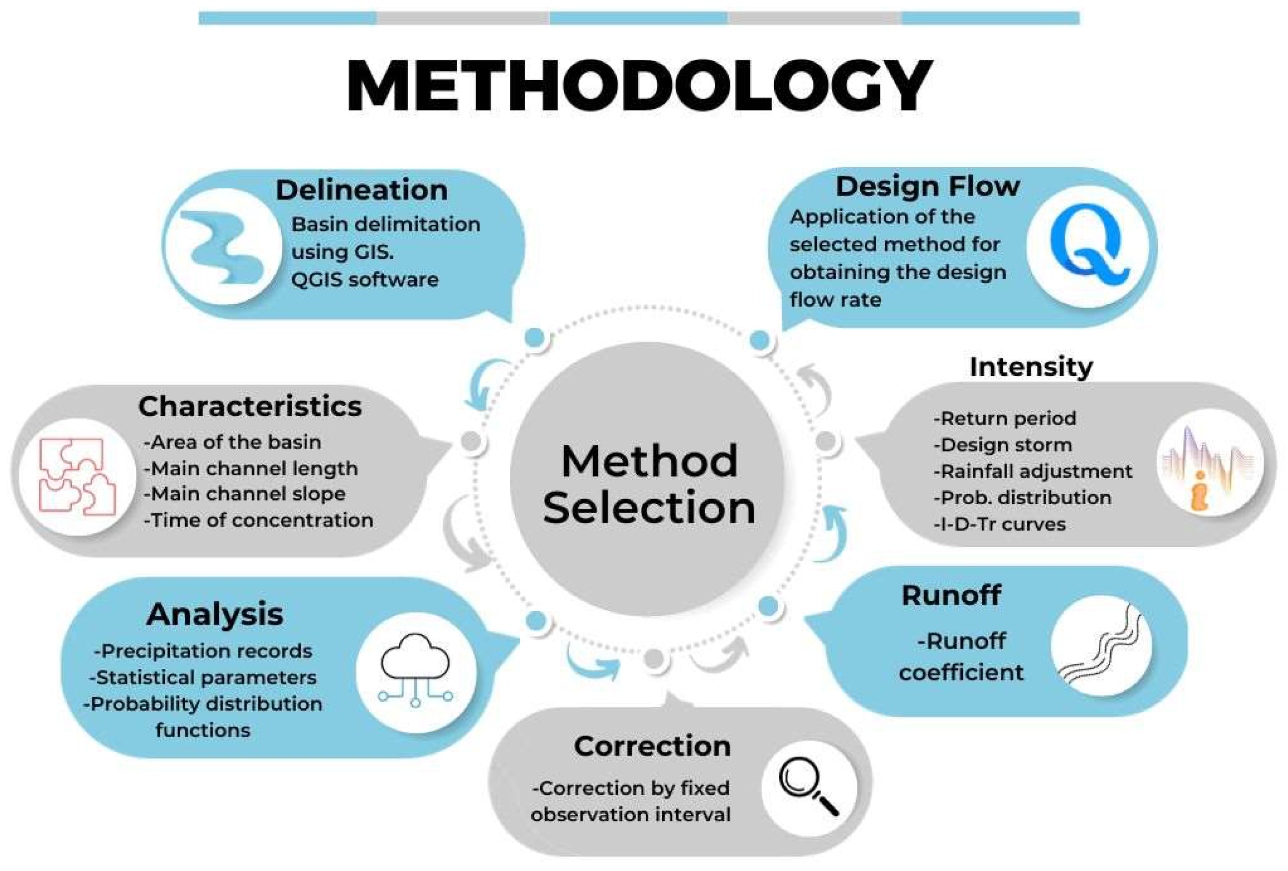
In this study, we proposed a standardized methodology to design a storm drainage system for a basin in Culiacan, México, using UAV, geographic information systems, and hydrological methods. The urban basin was delineated using a high-resolution DEM obtained from a photogrammetric process by using a UAV for image acquisition. The basin had an area of 0.42 km2, a perimeter of 2.8 km, a length of 1.1 km, a slope of 0.02, and a time of concentration of 11.56 min.
The probability distribution that best fitted the rainfall data was Gumbel of two populations, and this was used to estimate the maximum daily precipitation for different return periods. The high-resolution orthophoto was used to identify different land uses in the study area, which were then used to calculate the runoff coefficients for each return period. The intensity–duration–frequency curves were obtained using the isohyet curves and Chen’s formula, and a design storm was defined with a return period of 10 years and a duration of 11.56 min. The resulting rainfall intensity was 166.9 mm/h.
With the proposed methodology, it is possible to perform standardized hydrologic studies to calculate design surface water flow rates in urban basins with little basic information. Such standardization would facilitate the review of hydrologic studies by researchers or authorities to analyze surface water flow or to authorize or deny construction permits. The most appropriate methods existing in the literature were selected for urban areas with scarce basic information, such as the case study area. This methodology includes the delineation of urban basins with precision, considering the layout of roads and urban and real estate storm drainage works. In addition, it emphasizes the study of urban surface flow patterns with a basin vision instead of an urban development zone. This would allow for the integration of results from sub-basins with the results for larger basins.

6. Future Research

The proposed methodology can be complemented with future research by including the influence of flow rate transfers to other basins through subsurface urban storm drainage systems. It is also appropriate to include the determination of the proportion of the total flow rate flowing through the sewer relative to that flowing through the roads at other points in the water parting of the basin under study. This could be performed by modeling the flow over the roadways in the basin.
Finally, model calibration could be carried out by conducting a study to propose a flow rate measurement network for the basin under study to compare theoretical results with the practical data obtained in the field.

Author Contributions

Conceptualization, S.A.R.-G. and G.Y.S.-N.; methodology, G.Y.S.-N.; software, G.Y.S.-N., Z.D.M.-F. and A.J.S.-G.; validation, J.G.R.-P., S.A.M.-A. and A.J.S.-G.; formal analysis, S.A.R.-G.; investigation, G.Y.S.-N.; resources, S.A.R.-G.; data curation, S.A.M.-A., Z.D.M.-F. and A.J.S.-G.; writing—original draft preparation, G.Y.S.-N.; writing—review and editing, S.A.R.-G.; visualization, J.G.R.-P.; supervision, S.A.R.-G.; project administration, S.A.R.-G.; funding acquisition, S.A.R.-G. All authors have read and agreed to the published version of the manuscript.

Funding

This research was funded by the Autonomous University of Sinaloa (PROFAPI 439 PRO_A1_033) and CONAHCYT through SNII funds.

Institutional Review Board Statement

Not applicable.

Informed Consent Statement

Not applicable.

Data Availability Statement

The data that support the findings of this study are available from the corresponding author upon reasonable request. The data are not publicly available due to privacy.

Acknowledgments

The authors would like to thank Fernando García Páez for his technical contribution at the beginning of the project, as well as Abel Rivera Buelna for his support in the initial versions of some figures.

Conflicts of Interest

The authors declare no conflict of interest.

References

  1. Bibi, T.S.; Reddythta, D.; Kebebew, A.S. Assessment of the Drainage Systems Performance in Response to Future Scenarios and Flood Mitigation Measures Using Stormwater Management Model. City Environ. Interact. 2023, 19, 100111. [Google Scholar] [CrossRef]
  2. SEMANAT Cuencas Hidrográficas. Fundamentos y Perspectivas Para Su Manejo y Gestión. Available online: https://www.researchgate.net/publication/280938710_Cuencas_hidrograficas_Fundamentos_y_perspectivas_para_su_manejo_y_gestion (accessed on 29 September 2023).
  3. Diogo, A.F.; do Carmo, J.A. Peak Flows and Stormwater Networks Design—Current and Future Management of Urban Surface Watersheds. Water 2019, 11, 759. [Google Scholar] [CrossRef]
  4. Sanz-Muoz, M.M.; Bravo-Peia, L.C.; Aguilar-Villegas, J.M. Análisis Del Impacto de Eventos Hidrológicos Extraordinarios Mediante Modelización Hidrológica: Caso Culiacán Sinaloa; SELPER: Ciudad Juárez, Mexico, 2015. [Google Scholar]
  5. Van Dijk, E.; Van Der Meulen, J.; Kluck, J.; Straatman, J.H.M. Comparing Modelling Techniques for Analysing Urban Pluvial Flooding. Water Sci. Technol. 2014, 69, 305–311. [Google Scholar] [CrossRef] [PubMed]
  6. Niemczynowicz, J. Urban Hydrology and Water Management—Present and Future Challenges. Urban Water 1999, 1, 1–14. [Google Scholar] [CrossRef]
  7. Yin, J.; Yu, D.; Yin, Z.; Liu, M.; He, Q. Evaluating the Impact and Risk of Pluvial Flash Flood on Intra-Urban Road Network: A Case Study in the City Center of Shanghai, China. J. Hydrol. 2016, 537, 138–145. [Google Scholar] [CrossRef]
  8. GeoEcoSphera S.C. Atlas de Peligros y/o Riesgos Del Municipio de Culiacán, Sinaloa, 1st ed.; GEOLMEX—Geología y Servicios de Ingeniería, Ed.; Gobierno de Culiacán: Culiacán, México, 2020. [Google Scholar]
  9. Kim, D.; Sun, Y.; Wendi, D.; Jiang, Z.; Liong, S.Y.; Gourbesville, P. Flood Modelling Framework for Kuching City, Malaysia: Overcoming the Lack of Data. Springer Water 2018, 1, 559–568. [Google Scholar] [CrossRef]
  10. Dąbrowska, J.; Menéndez Orellana, A.E.; Kilian, W.; Moryl, A.; Cielecka, N.; Michałowska, K.; Policht-Latawiec, A.; Michalski, A.; Bednarek, A.; Włóka, A. Between Flood and Drought: How Cities Are Facing Water Surplus and Scarcity. J. Environ. Manag. 2023, 345, 118557. [Google Scholar] [CrossRef]
  11. UAS Estación Climatológica de la Facultad de Biología. Available online: https://www.uas.edu.mx/servicios/clima/ (accessed on 29 September 2023).
  12. Culiacán, A. Reglamento de Construcciones Para El Municipio de Culiacán, Sinaloa. Periodico Oficial del Estado de Sinaloa, 10 February 2021; 121. [Google Scholar]
  13. INEGI Hidrografía. Available online: https://www.inegi.org.mx/temas/hidrografia/ (accessed on 27 May 2022).
  14. El Clima En Culiacán, El Tiempo Por Mes, Temperatura Promedio (México)—Weather Spark. Available online: https://es.weatherspark.com/y/3157/Clima-promedio-en-Culiac%C3%A1n-M%C3%A9xico-durante-todo-el-a%C3%B1o (accessed on 16 May 2023).
  15. SMN Resúmenes Mensuales de Temperaturas y Lluvia. Available online: https://smn.conagua.gob.mx/es/climatologia/temperaturas-y-lluvias/resumenes-mensuales-de-temperaturas-y-lluvias (accessed on 29 September 2023).
  16. GS Atlas de Riesgos Del Estado de Sinaloa. Available online: http://www.atlasnacionalderiesgos.gob.mx/AtlasEstatales/?&NOM_ENT=Sinaloa&CVE_ENT=25 (accessed on 29 September 2023).
  17. OMM. International Glossary of Hydrology Glossaire Intenational D’Hydrologie MEЖДУHAPOДHЫЙ ГИДPOЛOГИЧECKИЙ CЛOBAPЬ Glosario Hidrológico Internacional, 3rd ed.; Jarraud, M., Ed.; World Meteorological Organization (WMO): Geneve, Switzerland, 2012; ISBN 978-92-63-03385-8. [Google Scholar]
  18. Rivera Buelna, A. Delimitación de Una Cuenca Urbana Mediante Metodología Basada en Fotogrametría. Caso Cuenca en la Ciudad de Culiacán, Sinaloa, México. Bachelor’s Thesis, Universidad Autónoma de Sinaloa, Culiacán, Sinaloa, 2023. [Google Scholar]
  19. Aranda, D.F.C. Introducción a La Hidrología Urbana; Printego: San Luis Potosí, Mexico, 2010; ISBN 9709511815. [Google Scholar]
  20. CENAPRED. Guía Básica Para Elaboración de Atlas Estatales y Municipales de Peligros y Riesgos: Conceptos Básicos Sobre Peligros, Riesgos y Su Representación Geográfica, 1st ed.; Ramos Radilla, V., Ed.; Secretaría de Seguridad y Protección Ciudadana: Ciudad de México, México, 2006; ISBN 970-628-904-6.
  21. Flowers-Cano, R.S.; Ortiz-Gómez, R.; Burgos-Flores, D.; León-Jiménez, J.E.; Balladares-Sánchez, M.Á. Comparación de Cuatro Técnicas Para Seleccionar La Distribución de Probabilidad de Mejor Ajuste Para El Análisis de Datos de Precipitación Máxima Anual En México. J. Energy Eng. Optim. Sustain. 2017, 1, 55–78. [Google Scholar] [CrossRef]
  22. Parece, T.E.; Campbell, J.B. Identifying Urban Watershed Boundaries and Area, Fairfax County, Virginia. Photogramm. Eng. Remote Sens. 2015, 81, 365–372. [Google Scholar] [CrossRef]
  23. Rodriguez, F.; Andrieu, H.; Morena, F. A Distributed Hydrological Model for Urbanized Areas—Model Development and Application to Case Studies. J. Hydrol. 2008, 351, 268–287. [Google Scholar] [CrossRef]
  24. Araújo, P.V.N.; Amaro, V.E.; Silva, R.M.; Lopes, A.B. Delimitation of Flood Areas Based on a Calibrated a DEM and Geoprocessing: Case Study on the Uruguay River, Itaqui, Southern Brazil. Nat. Hazards Earth Syst. Sci. 2019, 19, 237–250. [Google Scholar] [CrossRef]
  25. Sanhouse-García, A.J.; Gabriel Rangel-Peraza, J.; Rentería-Guevara, S.A.; Bustos-Terrones, Y.A.; Mora-Félix, Z.D.; Plata-Rocha, W.; Alberto Monjardin-Armenta, S. Flood-Prone Area Delineation in Urban Subbasins Based on Stream Ordering: Culiacan Urban Basin as a Study Case. Sustainability 2021, 13, 13513. [Google Scholar] [CrossRef]
  26. Pusineri, G.; Pedraza, R.; Lozeco, C. Uso de Modelos Digitales de Elevación y de Sistemas de Información Geográfica En La Modelación Hidrológica. Geog. Digit. 2005, 2, 1–8. [Google Scholar] [CrossRef]
  27. Rentería-Guevara, S.A.; Rangel-Peraza, J.G.; Rodríguez-Mata, A.E.; Amábilis-Sosa, L.E.; Sanhouse-García, A.J.; Uriarte-Aceves, P.M. Effect of Agricultural and Urban Infrastructure on River Basin Delineation and Surface Water Availability: Case of the Culiacan River Basin. Hydrology 2019, 6, 58. [Google Scholar] [CrossRef]
  28. Rentería-Guevara, S.A.; Rangel-Peraza, J.G.; Bustos-Terrones, Y.A.; Amábilis-Sosa, L.E.; Rodríguez-Mata, A.E. Hydrological Basins in Mexico: Divisions and Legal Definition; Springer: Cham, Switzerland, 2020; pp. 17–43. [Google Scholar]
  29. INEGI Hidrología. Available online: https://www.inegi.org.mx/temas/hidrologia/#Mapa (accessed on 19 May 2023).
  30. Cisneros, S.; García, É.; Montoya, K.; Sinde, Í. Estudio de Las Configuraciones de Puntos de Control Terrestre Para Fotogrametría Con Drone. Rev. Geoespacial 2019, 16, 43–57. [Google Scholar] [CrossRef]
  31. Mora-Felix, Z.D.; Sanhouse-Garcia, A.J.; Bustos-Terrones, Y.A.; Loaiza, J.G.; Monjardin-Armenta, S.A.; Rangel-Peraza, J.G. Effect of Photogrammetric RPAS Flight Parameters on Plani-Altimetric Accuracy of DTM. Open Geosci. 2020, 12, 1017–1035. [Google Scholar] [CrossRef]
  32. Robredo Sánchez, J.C.; Mintegui Aguirre, J.Á. Diseño de Un Modelo Distribuido Elemental Para El Análisis Del Comportamiento Hidrológico de Una Cuenca Vertiente. Ing. Agua 1994, 1, 79–100. [Google Scholar] [CrossRef]
  33. Aparicio Mijares, F.J. Fundamentos de Hidrología de Superficie, 1st ed.; Editorial Limusa: México City, México, 2008; ISBN 139789681830144. [Google Scholar]
  34. Campos-Aranda, D.F. Calibración Del Método Del Coeficiente de Escurrimiento Para Estimación de La Disponibilidad Anual En Dos Zonas Geográficas de México. Ing. Hidráulica México 2009, 24, 12. [Google Scholar]
  35. Campos, D.F. Identificación Del Número N Con Base En El Método Del HUT, En Quince Cuencas Rurales de Dos Zonas Geográficas de México. Agrociencia 2009, 43, 763–775. [Google Scholar]
  36. Mejía Marcacuzco, J.A. Probabilidad y Estadística En Hidrología, 1st ed.; Mejía Marcacuzco, J.A., Ed.; Universidad Nacional Agraria la Molina: Lima, Peru, 2017; Volume 1, ISBN 9786124147913. [Google Scholar]
  37. US COE 33 CFR § 222.6—National Program for Inspection of Non-Federal Dams. Electronic Code of Federal Regulations (e-CFR)|US Law|LII/Legal Information Institute. Available online: https://www.law.cornell.edu/cfr/text/33/222.6 (accessed on 29 September 2023).
  38. Weiss, L.L. Ratio of True to Fixed-Interval Maximum Rainfall. J. Hydraul. Div. 1964, 90, 77–82. [Google Scholar] [CrossRef]
  39. WMO. Manual on Estimation of Probable Maximum Precipitation (PMP): WMO-No. 1045, 2nd ed.; Stewart, B., Ed.; World Meteorological Organization: Geneva, Switzerland, 2009; Volume 1, ISBN 978-92-63-11045-9. [Google Scholar]
  40. Llabrés-Brustenga, A.; Rius, A.; Rodríguez-Solà, R.; Casas-Castillo, M.C. Influence of Regional and Seasonal Rainfall Patterns on the Ratio between Fixed and Unrestricted Measured Intervals of Rainfall Amounts. Theor. Appl. Clim. 2020, 140, 389–399. [Google Scholar] [CrossRef]
  41. CONAGUA Manual de Agua Potable, Alcantarillado y Saneamiento. Drenaje Pluvial Urbano, 1st ed.; Agua Potable, S.G., Ed.; CONAGUA: Ciudad de México, Mexico, 2019; Volume 1, ISBN 978-607-626-019-7.
  42. García Páez, F.; Rentería Guevara, S.A. Evaluación de Riesgo Por Inundaciones En Cuencas Urbanas Con Base En Caracterización Morfométrica y Análisis de La Dirección Del Flujo de Agua Superficial. Caso de Estudio: Cuenca En Culiacán, Sinaloa, 1st ed.; Universidad Autónoma de Sinaloa: Culiacán, México, 2022. [Google Scholar]
  43. Maidment, D.R. Handbook of Hydrology, 1st ed.; Maidment, D.R., Ed.; McGraw-Hill: New York, NY, USA, 1993; ISBN 0070397325/9780070397323. [Google Scholar]
  44. Bell, F.C. Generalized Rainfall-Duration-Frequency Relationship Applicability in Different Climatic Regions of Argentina. J. Hydrol. Eng. 1969, 9, 311–327. [Google Scholar]
  45. Chen, C. Rainfall Intensity-Duration-Frequency Formulas. J. Hydraul. Eng. 1983, 109, 1603–1621. [Google Scholar] [CrossRef]
  46. Misra, A.K. Impact of Urbanization on the Hydrology of Ganga Basin (India). Water Resour. Manag. 2011, 25, 705–719. [Google Scholar] [CrossRef]
  47. Wang, S.; Wang, H. Extending the Rational Method for Assessing and Developing Sustainable Urban Drainage Systems. Water Res. 2018, 144, 112–125. [Google Scholar] [CrossRef]
  48. Shaikh, M.P.; Yadav, S.M.; Manekar, V.L. Assessment of the Empirical Methods for the Development of the Synthetic Unit Hydrograph: A Case Study of a Semi-Arid River Basin. Water Pract. Technol. 2022, 17, 139–156. [Google Scholar] [CrossRef]
  49. Rao, K.N. Analysis of Surface Runoff Potential in Ungauged Basin Using Basin Parameters and SCS-CN Method. Appl. Water Sci. 2020, 10, 47. [Google Scholar] [CrossRef]
  50. Sultan, D.; Tsunekawa, A.; Tsubo, M.; Haregeweyn, N.; Adgo, E.; Meshesha, D.T.; Fenta, A.A.; Ebabu, K.; Berihun, M.L.; Setargie, T.A. Evaluation of Lag Time and Time of Concentration Estimation Methods in Small Tropical Watersheds in Ethiopia. J. Hydrol. Reg. Stud. 2022, 40, 101025. [Google Scholar] [CrossRef]
  51. Lapides, D.A.; Sytsma, A.; Thompson, S. Implications of Distinct Methodological Interpretations and Runoff Coefficient Usage for Rational Method Predictions. J. Am. Water Resour. Assoc. 2021, 57, 859–874. [Google Scholar] [CrossRef]
  52. Cheng, X.; Ma, X.; Wang, W.; Xiao, Y.; Wang, Q.; Liu, X. Application of HEC-HMS Parameter Regionalization in Small Watershed of Hilly Area. Water Resour. Manag. 2021, 35, 1961–1976. [Google Scholar] [CrossRef]
  53. Xu, Z.; Xiong, L.; Li, H.; Xu, J.; Cai, X.; Chen, K.; Wu, J. Runoff Simulation of Two Typical Urban Green Land Types with the Stormwater Management Model (SWMM): Sensitivity Analysis and Calibration of Runoff Parameters. Environ. Monit. Assess. 2019, 191, 343. [Google Scholar] [CrossRef] [PubMed]
  54. Salman, A.; Hassan, S.S.; Khan, G.D.; Goheer, M.A.; Khan, A.A.; Sheraz, K.; Salman, A.; Hassan, S.S.; Khan, G.D.; Goheer, M.A.; et al. HEC-RAS and GIS-Based Flood Plain Mapping: A Case Study of Narai Drain Peshawar. Acta Geophys. 2021, 69, 1383–1393. [Google Scholar] [CrossRef]
  55. Feng, B.; Zhang, Y.; Bourke, R. Urbanization Impacts on Flood Risks Based on Urban Growth Data and Coupled Flood Models. Nat. Hazards 2021, 106, 613–627. [Google Scholar] [CrossRef]
  56. Campos Aranda, D.F. Intensidades Máximas de Lluvia Para Diseño Hidrológico Urbano En La República Mexicana. Available online: https://www.scielo.org.mx/scielo.php?script=sci_arttext&pid=S1405-77432010000200005 (accessed on 30 September 2023).
Figure 1. Location of study area.
Applsci 13 12334 g001
Figure 2. Methodology for the standardization of urban hydrological studies.
Applsci 13 12334 g002
Figure 3. Basin divide tracing.
Applsci 13 12334 g003
Figure 4. Flow directions and representative points of the basin divide.
Applsci 13 12334 g004
Figure 5. Delineation of the basin with its respective flow directions.
Applsci 13 12334 g005
Figure 6. Drawing of polygons to identify the different surfaces.
Applsci 13 12334 g006
Figure 7. Intensity duration frequency curves.
Applsci 13 12334 g007
Table 1. Daily maximum precipitation at the station of the School of Biology [11].
YearDMP (mm)YearDMP (mm)
1995250.3200969.9
1996224201069.9
1997157.7201167
1998152.8201267
1999111.3201360.8
2000103201460.2
2001101.4201559.5
200287.7201658.3
200384.3201758.2
200484201855.4
200580.3201954.5
200677.4202051.6
200772.9202139.7
200871
Table 2. Adjusted maximum daily precipitation for different return periods.
Return Period (Years)Precipitation Height (mm)
279.439
5127.69
10185.32
20232.78
25246.34
50284.76
100317.53
Table 3. Main geomorphological parameters of the study basin.
Area (ha)Perimeter (m)Length of Main Stream (m)SlopeTc (h)Tc (min)
21.27128495680.02020.19311.56
Table 4. Pondered runoff coefficients with return periods (TR) of 2, 5, and 10 years.
SurfacesArea (km2)C-TR-2C-TR-5C-TR-10
Land without vegetation0.7690.10.250.35
Roof1.3310.80.850.9
Inclined roof9.6740.80.850.9
Sidewalk0.6330.10.250.35
Concrete street5.5830.870.880.9
Asphalt1.3600.870.880.9
Landscaped area1.7910.10.250.35
Total area21.140.720.770.82
Table 5. Rainfall intensities (mm/h) for different return periods and durations.
Tr (Years)Duration (min)
5101520304560801001201440
2115.8589.2673.9163.7450.9040.0133.4927.9024.1521.443.99
5181.45139.80115.7699.8479.7262.6752.4543.7037.8333.586.25
10231.08178.03147.42127.15101.5279.8166.8055.6548.1842.777.96
25296.68228.57189.27163.24130.34102.4785.7671.4561.8654.9110.23
50346.30266.81220.93190.55152.14119.61100.1183.4072.2164.1011.94
100395.93305.04252.59217.85173.94136.75114.4595.3582.5573.2813.65
Table 6. Flow rates calculated using the different methods (m3/s).
Rational MethodChow MethodSCS Method
Hydrograph of Direct RunoffTriangular Unit Hydrograph
8.074.5696.3712.964
Disclaimer/Publisher’s Note: The statements, opinions and data contained in all publications are solely those of the individual author(s) and contributor(s) and not of MDPI and/or the editor(s). MDPI and/or the editor(s) disclaim responsibility for any injury to people or property resulting from any ideas, methods, instructions or products referred to in the content.

