Structural Evolution of the Kohat Fold and Thrust Belt in the Shakardarra Area (South Eastern Kohat, Pakistan)


1
Department of Geophysics, School of Geodesy and Geomatics, Wuhan University, Wuhan 430079, China
2
Department of Earth and Environmental Sciences, Bahria University, Islamabad 44000, Pakistan
3
Key Laboratory of Geospace Environment and Geodesy of Ministry of Education, Wuhan University, Wuhan 430079, China
4
Collaborative Innovation Center of Geospace Information Science, Wuhan University, Wuhan 430079, China
*
Author to whom correspondence should be addressed.
Geosciences 2018, 8(9), 311; https://doi.org/10.3390/geosciences8090311
Submission received: 24 May 2018
/
Revised: 8 August 2018
/
Accepted: 16 August 2018
/
Published: 21 August 2018
Abstract
:The Kohat fold and thrust belt, located in North-Western Pakistan, is a part of Lesser Himalaya developed due to the collision between the Indian and Eurasian plates. The structural evolution records of this area indicate that it consists of tight anticlines and broad syncline structures. Previous studies show that the structural pattern of this area has been produced due to multiple episodes of deformation. In the present research, 2D seismic data has been integrated with our field surveys to clarify the role of active strike-slip faulting in reshaping the surface structures of Shakardarra, Kohat. At the surface, doubly plunging anticlines and synclines are evolved on evaporites as detachment folds, truncated by thrust faults along their limbs. Seismic data show that the thrust faults originate from basal detachment located at the sedimentary-crystalline interface and either cut up section to the surface or lose their displacement to splay or back thrusts. At the surface, the Shakardarra Fault, the Tola Bangi Khel Fault, the Chorlaki Fault, and the axial trend of fold change their strike from EW to NS showing that the thrust and axial trend of folds are rotated along the vertical axis by the influence of the Kalabagh strike-slip fault. Strike-slip motion dominates the style of deformation at the northern segment. The current deformation is concentrated on the splay faults in the northern segment of the Kalabagh Fault. We propose that Shakardarra is sequentially evolved in three episodes of deformation. In the first phase, the detachment folds developed on Eocene evaporites, which are truncated by thrust faults originated from the basal detachment in the second phase. In the third phase, early formed folds and faults are rotated along the vertical axis by the influence of Kalabagh strike-slip fault.
1. Introduction
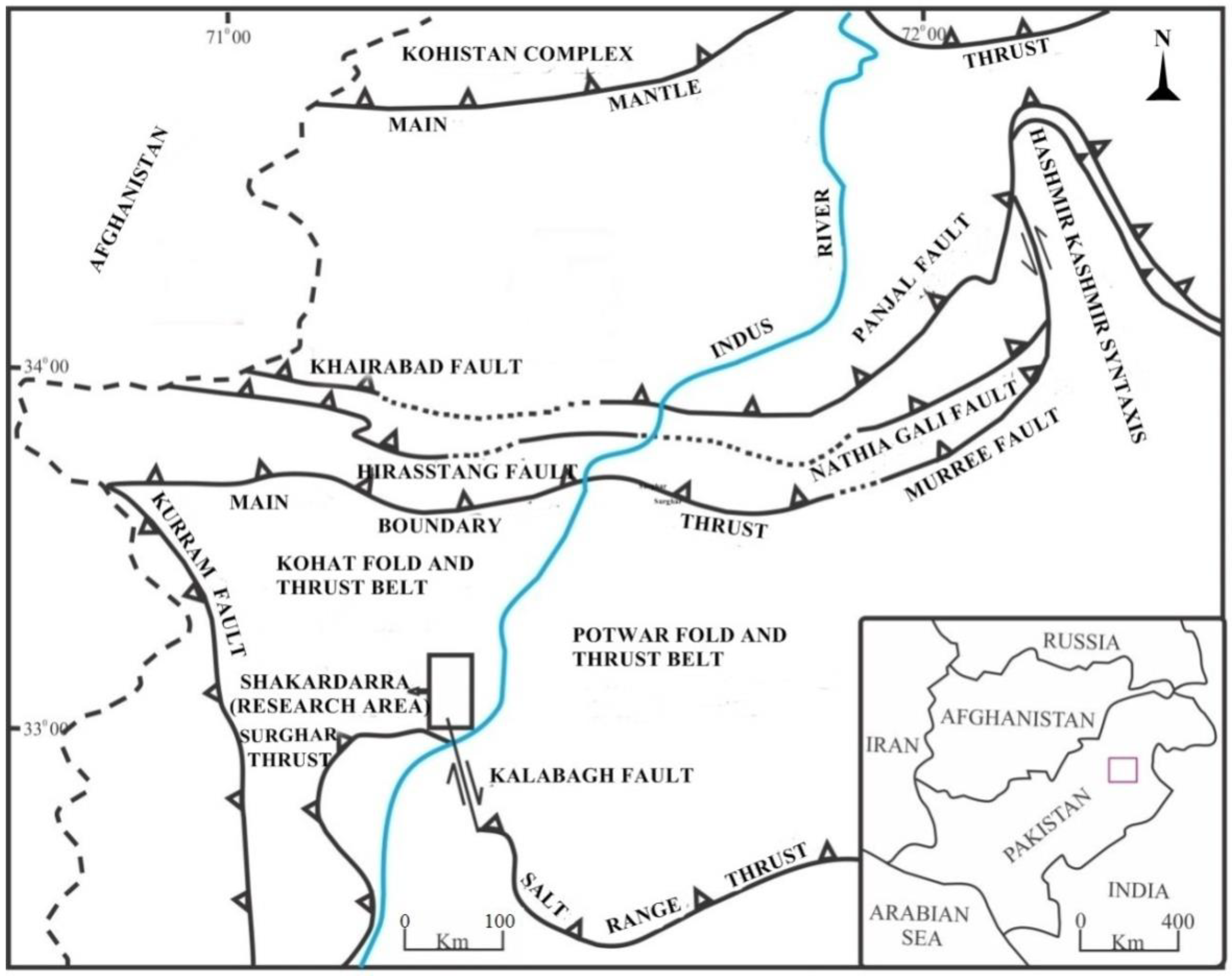
The oroclinal trend of the Himalayas is NW-SE in India; it changes to EW in Pakistan, and becomes NS along the western border of Pakistan [1]. The Kohat plateau comprises of Eocene and younger sedimentary rocks in a tectonically restricted basin and is located in the west of the Potwar fold and Thrust belt (Figure 1).
The Kohat Fold and Thrust Belt (KFTB) also known as Kohat Plateau belong to the Himalayan Fold and Thrust System located in the Sub Himalayas. The KFTB extends from the Main Boundary Thrust (MBT) in the north [2,3,4,5,6,7,8,9,10,11,12,13] to Surghar range in the south [14] (Figure 1). It is separated from its counterpart Potwar Fold and Thrust Belt (PFTB) by the Indus River and its western boundary is marked by Kurram Fault [3] (Figure 1). KFTB and PFTB are genetically related to Himalayan induced deformation [1,2,3,4,8,9,10,11,14,15,16,17,18]. However, the structural complexity is more pronounced in KFTB. In the study area, Shakardarra is located at the boundary between KFTB and PFTB with an active Kalabagh strike-slip fault in the southern portion (Figure 1).
1.1. Straigraphy of the Area
The stratigraphic column of the study area is shown in Figure 2. In the southern part, the plateau consists of evaporites. In the northern part, the Evaporite sequence is missing or reduced and is concentrated in the central one. The stratigraphic column shows data from the field area in southern Kohat from Eocene to Pliocene. The Cherat group consists of Jatta Gypsum, Kuldana formation, and Kohat formation [4]. Jatta Gypsum consists of Gypsum with the interbeds of gypsiferous shale. The Kuldana formation consists of red silty clay with thin beds of limestone. Both of these formations have conformable lower and upper contacts. The Kohat formation consists of calcareous shale and light grey limestone (Figures S1 and S2). The lower contact is conformable with the Kuldana formation whereas the upper contact is unconformable with the Murree formation of the Rawalpindi group. The Rawalpindi group is sub divided into the Murree and Kamlial formations [4]. The Murree formation is composed of red purple sandstone and marl. Its upper contact is conformable with Kamlial formation whereas the lower contact is unconformable with the Eocene formation. The Kamlial formation consists of grey to greenish grey sandstone (Figure S3). Its upper and lower contact is conformable. The Siwalik group consists of Chinji, Nagri, and Dhokpathan formations [4]. The Chinji formation consists of red clay with subordinate fine-grained soft sandstone (Figure S4) whereas the Nagri formation consists of sandstone with interbeds of the intra-formational conglomerate. The Dhopathan formation consists of grey to light grey sand stone. The Chinji and Nagri formations have conformable lower and upper contacts. The Dhokpathan formations have conformable lower contact, whereas the upper contact is unconformable.
1.2. Structural Geology of the Area
Kohat has a distinct passive roof duplex geometry, formed of thrust slices of pre-Tertiary stratigraphy. The Transpression related wrench fault that is responsible for the structures exposed at the surface and subsurface has been suggested by previous studies [6]. The study area is comprised of fold and thrust belt assemblages which are thin skinned structures superimposed by thick-skinned structures [15]. The major part of the plateau is dominated by compressional structures; however, the strike-slip faulting is confined to the southern Kohat plateau. In the east of Shakardarra, the east-west trending structures change their orientation to the north-south direction (Figure 3). The previous models pinpoint the lateral ramp in the subsurface, causing the surface structures to change their orientation across it [1]. The Kohat Plateau consists of a heavily deformed and structurally elevated thrust sheet. Pop-ups, broad synclines, a narrow fault, and evaporite-cored anticlines record a high-level translation of a large thrust mass along the Eocene evaporites. Khan et al. [7] discussed the nature and kinematics of the Kalabagh strike-slip fault. The integration of the surface and subsurface geology provides new insights on the geometry and evolution of the Kalabagh Fault Zone by showing that it forms an oblique ramp to the Main Frontal Thrust and at north, a lateral ramp with the right-lateral strike slip movement. The results indicate that the presence and areal extent of the evaporites is the dominant factor controlling the lateral structural variation in the NW Himalayan fold-and-thrust belt of Pakistan. The Kalabagh Fault Zone acts as a zone that accommodates the differential shortening and structural variation along the orogenic trend. Combining the surface geology with the seismic interpretation, the Kalabagh Fault Zone is divided into two segments of different tectonic activity. Its northern segment is predominantly of a strike-slip nature with salt diapirism and the upward migration of salt. South to Khairabad, the major fault is a lateral ramp of the Main Frontal Thrust the Potwar fold and thrust belt and the Salt range thrust wedge propagate southward quicker and farther than the Kohat fold and thrust belt and the Surghar thrust wedge due to the lubricating effect of the salt. A lateral structure, the Kalabagh Fault Zone, formed as a transfer zone to accommodate the different deformational styles between two thrust wedges.
However, the previously developed models did not consider the role of active strike slip faulting in the deformational history. The exposed structures at Shakardarra do not comply completely with the concept of the lateral ramp. The continuation of the structures in the north of Shakardarra with an east-west trend may rule out the sole presence of a lateral ramp in the subsurface, affecting the structures on the surface. The aim of present research is to understand the structural evolution of the area in relation to fold and thrust kinematics and to diagnose the role of active strike-slip faulting in reshaping the structures at surface and subsurface. A 2D geoseismic model of the area is employed to map the genetic relationship between surface and subsurface structures.
2. Materials and Methods
Revised geological mapping (Figure 3) of the area is done by integrating published maps and field data. For the collection of field data, we have to visit different areas looking for large faults exposed on the surface (Figures S5 and S6). During the field work, Dip and strike data were collected and the stratigraphic relationships were marked and mapped on the base map. The field data collected was used in the preparation of the geological sketch of Figure 3.The seismic reflection data of five lines acquired with the special permission from Directorate General of Petroleum Concession ((DGPC): 865-NK-02 (EF), 865-NK-05 (GH), 865-NK-08 (CD), 865-NK-11 (IJ), and 865-NK-15 (AB) (Figures S7 and S16) are used for the interpretation of subsurface structures, stratigraphy, and the depth of basement. The methodology used for the interpretation of seismic lines is given in the supplementary file. The seismic data were2D data, so the interpretation was difficult due to the high deformation and presence of the salts in the area. The presence of salts in the area gives a low S/N ratio due to which the data is not clear. The data could be improved by means of a 3D seismic survey in the area. The interpretation is also supported by the observations of previous studies [1,5,15,16].
3. The Surface Geological Frame Work of Shakardarra Area
The structural geology of the research area is predominantly controlled by the thrust tectonics and is comprised of outcropping thrust faults and folds. The structures at the surfaces are transected and elevated by imbricated thrust faults and blind thrusts present in the sub surface [10]. The general trend of the structures in the area is ENE–WNW. Fault bounded doubly plunging anticlines and broader synclines are present at the surface. A revised geological map of the area was organized by integrating the published geological map [14] and field data (Figure 3). The Dartapi Fault is present in the northern side of the study area and the strike of the fault is ENE-WSW. From the East to the West, the fault has thrusted the Eocene Jatta Gypsum over the Chinji formation in the foot-wall. In the western part, the fault trace at the surface is covered by alluvium. The average dip of fault is 40°–45° N. The dip is calculated in the field by measuring the stratigraphic horizons in the hanging-wall. The seismic shows that the behavior of the fault changes in the section. The field data itself cannot be projected very deep into the section. The Field data have provided important constraints for the position of the faults and for correlating the surface structural geology to subsurface seismic. A Karappa Fault is ENE–WSW trending, from east to west and had thrusted the Eocene package over Kamlial formation lying in the foot-wall of the fault. In the northwest of the study area, a back thrust is present above the Karappa Fault which is thrusting Eocene Jatta Gypsum over the Kamlial formation in foot-wall. In the southeast, the plunging anticline is present in the hanging-wall of these faults. A Nandraki Fault is present in the north, thrusting the Eocene Jatta Gypsum over the Kamlial formation (Figure S15) and has an E–W orientation. A NW plunging anticline is present in the hanging-wall of the thrust. The southern limb of the fold is truncated by the Nandraki Fault. The Braghzaibanda Fault is present in the Centre of the study area and is a high angle thrust fault cropping out on the surface. The orientation is ENE–WSW and generally had thrusted the Eocene Jatta Gypsum on the hanging-wall of the fault over the Chinji formation lying in the foot-wall (Figure S16). To the west, an anticline is present, which has a Kamlial formation in the core and the Chinji formation in the limbs. The Shakardarra Fault is present in the central part of the study area. The strike of the fault is EW and changes to NS. The fault had thrusted the Eocene package on the Nagri formation to the east of the area. In the center, this fault had thrusted the Kamlial formation over the Chinji formation located in its foot-wall and towards the west, the fault had thrusted the Eocene over Kamlial located in its foot-wall. A syncline exits in the hanging-wall of the fault, which is comprised of the Kamlial formation in the core and the Eocene in the limbs. The Bab-e-Shakardarra Fault (BSF) and Nari Banda Fault (NBF) had thrusted Eocene Jatta Gypsum over the Kamlial formation in the foot-walls. BSF and NBF are the splay faults originating in the North from Shakardarra Fault (SF). The right lateral strike-slip fault is present in the southern part of the study area (Figure 3). A steeply dipping Nagri formation is present on both sides of the fault surface trace. Tola Bangi Khel Fault (TBKF) had thrusted the Nagri formation in hanging-wall over the Dhokpathan formation in the foot-wall and the strike of the fault is EW in the western portion, which changes to NW-SE in the eastern part. The Kalabagh strike-slip fault has a significant impact on this area as it is a Right lateral strike-slip fault. The orientation of the Kalabagh Fault in this area is NS. TBKF and CF join the Kalabagh Fault and are kinematically linked. The strike-slip motion in the Kalabagh Fault Zone is related to the thrust slip motion along these faults.
Tight anticlines and broad synclines are present in the area and the faults are transecting the limbs of the anticlines. The Banda Lakhoni Syncline (BLS) is an open synclinal structure plunging towards its core. In the core, it consists of Nagri formation and on the northern limb Chinji formation. On the southern limb, it is transected by the TBKF. The Tangai Banda Syncline (TBS) contains the Dhokpathan formation in the core and the Nagri formation at limbs is exposed in the north eastern part of the study area. It plunges towards its core and the surface axial trace of the syncline is NE–SW. The Ziarat Banda Syncline contains the Dhokpathan formation in the core whereas, on the southern limb, it consists of the older formation, that is, the Nagri formation. The northern limb is transected by the TBKF.
4. Cross Sections
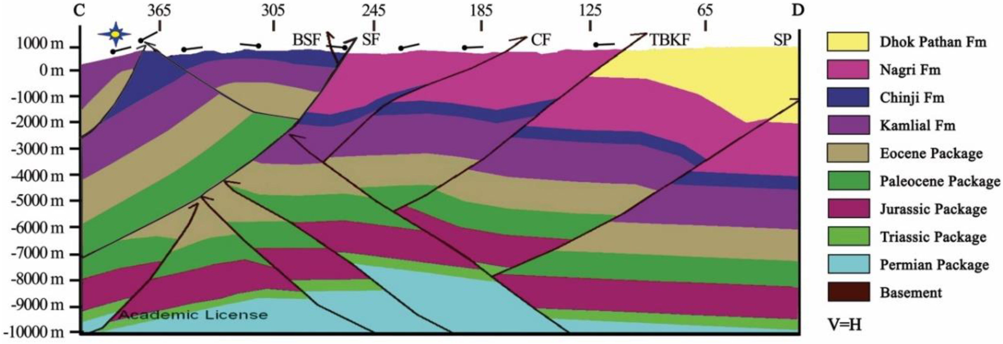
Five cross sections AB, CD, EF, GH, and IJ are constructed to understand the structural style at the surface and subsurface along the seismic lines. The cross sections are constructed in the integration of the surface attitude and seismic data up to a depth of 10 km. Section AB and CD are constructed along the dip lines 865-NK-15 and 865-NK-08. Section EF, GH, and IJ were constructed along the strike lines 865-NK-02, 865-NK-05, and 865-NK-11, respectively. Sections AB and CD are perpendicular to the structural grain, whereas the others are oblique to the structural grain. The sections are drawn on the seismic profiles.
The faults in the subsurface were marked on the basis of the offsets in the reflector while the faults exposed at the surface were marked on the seismic section in relation to the shot points at the surface. The cross sections are prepared manually by interpolation of the surface geological data (contacts and orientations) and subsurface depth domain data of the reflectors are redrawn on 2Dmove software to maintain the same accuracy for the thickness of each horizon. Cross sections are later used for 2D model generation.
4.1. Section AB and CD
Sections AB and CD are north-south orientated for17.5 and 18.5 km, respectively. On the seismic data, the basement reflector is not marked. The previous work marked the basement on 4 TWT on the seismic and is shown in section at 10 km [13]. The basement constraints in our section are marked at 10 km. In the northern part of section AB (Figure 4) and CD (Figure 5), the Braghzaibanda Fault (BBF) and Shakardarra Fault (SF) are thrust faults originating from the basal detachment to the surface. Nari Banda Fault (NRF) is also present in section CD. The Bab-e-Shakardarra Fault (BSF) and two splay faults originate at a shallow depth in the north and south of Shakardarra Fault. The Braghzaibanda Fault is present in the center of the study area. It is a high angle thrust fault cropping out on the surface. BoththeNari Banda Fault and Bab-e-Sharakardarra Fault had thrusted the Eocene Jatta Gypsum over the Kamlial formation in the footwall. It has thrusted the Eocene rocks over the Chinji formation which is lying on the footwall. The Eocene rocks are thrusted over the younger rocks by these two thrust faults. At the south of SF, an open anticlinal and synclinal structure are transected by a complex network of faults. In the subsurface, the north facing thrust had uplifted the stratigraphic section towards the north at a deeper level. The Tola Bangi Khel Fault and Chorlaki Fault originate as south facing faults from a north facing thrust atthe deeper level transecting the limbs of folds. The Tola Bangi Khel Fault had thrusted the Nagri formation in the hanging-wall over the Dhokpathan formation in the foot-wall. The triangular zones are formed at a depth in between the opposite facing thrusts.
4.2. Sections EF, GH, and IJ
Sections EF, GH, and IJ are orientated in the NE-SW direction and are 27.1, 29.4, and 32.5 km long, respectively. Sections EF (Figure 6), GH (Figure 7), and IJ (Figure 8) are oriented obliquely to the strikes of the exposed structures. NRF is present in the EF section thrusted Eocene rocks over the Kamlial formation. SF is present in all sections and had thrusted Eocene rocks over the Kamlial and Nagri formations. The Shakardarra Fault had thrusted the Eocene rocks on the Nagri formation, the Kamlial formation over the Chinji formation and the Eocene over the Kamlial formation. NRF and SF cut through the section potentially from the basal detachment to the surface. Tola Bangi Khel Fault in the sections GH and IJ are thrusting over the Nagri formation in the hanging-wall and over the Dhokpathan formation in the foot-wall. In the subsurface, the Pop-up and triangle zones are present.
5. Discussion
The model was mostly based on structural geology. Geologically, Shakardarra is comprised of complex deformational structures and might have been developed and modified by multiple deformational events. The structural models of the area show the distribution of structures in two dimensions at the surface and subsurface. The area is occupied by tight anticlinal structures in the south. The presence of the Eocene Jatta Gypsum in the core of the anticlinal structures indicates that the folds are formed as a result of detachment folding on the Eocene evaporites. The truncation of folds at the limbs by the faults narrates that the faults are emplaced later. The trend of the folds are axial traces and the faults are ENE to WSW, which indicates their development is genetically linked to Himalayan induced deformation. The cross sections show that these faults developed from a basal detachment located at the sedimentary-crystalline interface. All cross sections show that the back thrust originated from the fore thrusts to the south of it. In the central portion of the area, a south-dipping blind thrust had uplifted the stratigraphic sequence northward in the subsurface. TBKF and CF originate from these blind back thrusts cut up sections to the surface. The faulting in the central formation of study area developed to achieve the critical taper for the initiation of the Surghar Range Frontal thrust in the south of Shakardarra.
The structural geology of the area in the central portion is comprised of pop-up and triangle zone geometries in the subsurface. The reservoir of Jurassic age is structurally uplifted and transected by these faults forming the structures favorable for hydrocarbons. The change in orientation of the Shakardarra Fault, Tola Bangi Khel Fault, and Chorlaki Fault from E–W to N–S in the eastern portion of the area is strongly influenced by the right lateral movement of the Kalabagh strike-slip fault present in the south-east of this area (Figure 9). The southward propagation of the deformation in Kalabagh, Potwar fold and the thrust belt, salt range thrust, and deformation halting in the Kohat fold and thrust belt resulted in the clockwise rotation of the strikes of faults from E–W to N–S.
Dominant flexure/bends in the strikes of the Surghar range thrust to the west of Kalabagh strike-slip fault and Shakardarra Fault to the east represents that the early formed thrusts are rotated along the vertical axis of rotation related to the Kalabagh strike-slip fault. The deformation related to the Kalabagh strike-slip fault had changed the orientation and dips of the Nagri formation to the vertical near the rotated fault plane of the Chorlaki Fault and Tola Bangi Khel Fault.
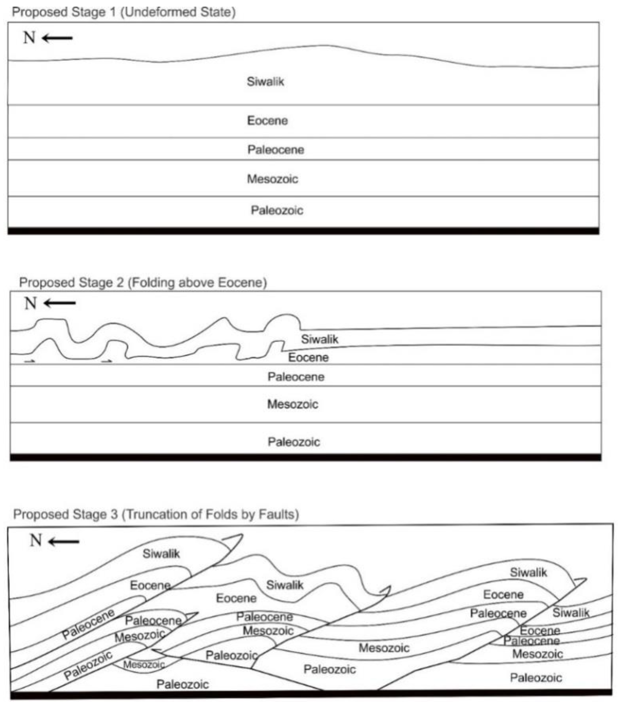
The previous model of Shakardarra [1] showed the presence of a lateral ramp and duplication in the Precambrian to Mesozoic strata. Our research suggests that the area evolved sequentially in three episodes of deformation. In the first phase of deformation folding developed on the Eocene evaporites horizons as detachment folds. In the second phase of deformation, the thrusting from the basal detachment had truncated the folded structures and elevated the whole stratigraphic sequence (Figure 10). In the third phase of deformation, early formed thrusts were rotated from EW to NS by the influence of the Kalabagh strike-slip fault. The strike-slip deformation in the Kalabagh Fault Zone developed these NE verging thrusts in the area. These faults have EW strike west of Kalabagh.
6. Conclusions
The model is prepared by integrating surface structural geological data and subsurface seismic reflection data. At the surface, the doubly plunging anticlines and synclines are evolved on evaporites as detachment folds truncated by thrust faults along their limbs. In the subsurface, the stratigraphic packages are marked on seismic sections suggesting that thrust faults originate from basal detachment located at presumably sedimentary crystalline interface cutting up section to surface or lose their displacement to splay or back thrusts. Two distinctive detachment horizons are present in the subsurface at a presumably sedimentary crystalline interface and Eocene evaporites sequence.
The general trend of faults and folds is ENE–WSW, which shows their genetic link to Himalayan induced deformation. The truncations of fold limbs by faults are emplaced later in the deformational history of the area. The back thrusts in the area are developed to achieve the critical taper for initiation of the fore thrust towards the south. The change in the strikes of Shakardarra Fault, Surghar range thrust, Tola Bangi Khel Fault, and the Chorlaki Fault indicates that these early formed thrusts are rotated along the vertical axis by the influence of the Kalabagh strike-slip fault. The area is evolved sequentially in three episodes of deformation: detachment folding followed by thrusting superimposed by strike-slip faulting.
Supplementary Materials
The following are available online at https://www.mdpi.com/2076-3263/8/9/311/s1, Figure S1 to Figure S16: Seismic Data Interpretation.
Author Contributions
H.H. collected the data, interpreted the seismic sections and wrote the manuscript. Z.S. wrote the manuscript, provided necessary guidance and comments during the entire process of this research.
Funding
This study is supported by the 973 Project of China (No. 2013CB733303), the National Natural Science Foundation of China (No. 41874169, 41474093 and 41704046), and China’s International Education Funding for Chinese-Pakistani students.
Conflicts of Interest
The authors declare no conflict of interest.
References
- Abbasi, I.A.; McElroy, R. Thrust kinematics in the Kohat Plateau, Trans Indus Range, Pakistan. J. Struct. Geol. 1991, 13, 319–327. [Google Scholar] [CrossRef]
- McDougal, J.W.; Hussain, A. Fold and thrust propagation in the western Himalaya based on a balanced cross section of the Surghar range and Kohat plateau, Pakistan. Am. Assoc. Pet. Geol. Bull. 1991, 75, 463–478. [Google Scholar]
- Kazmi, A.H.; Rana, R.A. Tectonic Map of Pakistan; Geological Survey: Quetta, Pakistan, 1982.
- Kadri, B.I. Porwar and Kohat Plateau. In Petroleum Geology of Pakistan; Pakistan Petroleum Limited: Karachi, Pakistan, 1995; p. 20. [Google Scholar]
- Meissner, C.R.; Master, J.M.; Rashid, M.A.; Hussain, M. Stratigraphy of Kohat Quadrangle, Pakistan; United States Geological Survey: Reston, VA, USA, 1974; Professtional Paper; 716–D.
- Pivnik, D.A.; Sercombe, W.J. Compression and transpression related deformation in the Kohat plateau, NW Pakistan. Geol. Soc. Lond. Spec. Publ. 1993, 74, 559–580. [Google Scholar] [CrossRef]
- Khan, S.D.; Cen, L.; Ahmad, S.; Ahmad, I.; Ali, F. Lateral structural variation along the Kalabagh fault zone, NW Himalayan foreland fold-and-thrust belt, Pakistan. J. Asian Earth Sci. 2012, 50, 79–87. [Google Scholar] [CrossRef]
- Chen, L.; Khan, S.D. Geomorphic features and tectonic activities in sub-Himalayan thrust belt, Pakistan, from satellite data. Comput. Geosci. 2009, 35, 2011–2019. [Google Scholar] [CrossRef]
- Coward, M.P.; Butler, R.W.H. Thrust Tectonic and the deep structure of the Pakistan Himalayan. Geology 1985, 13, 417–420. [Google Scholar] [CrossRef]
- Kazmi, A.H.; Jan, Q.M. Stratigraphic setting. In Geology and Tectonics of Pakistan; Graphic Publishers: Karachi, Pakistan, 1997; p. 139. ISBN 969-8375-00-7. [Google Scholar]
- Khan, A.A. Structure and Tectonic Setup of the Area, South and Southwest of Kohat, N.W.F.P., Pakistan. Master’s Thesis, National Center of Excellence in Geology (NCEG)NCE in Geology, University of Peshawar, Peshawar, Pakistan, 1999. Unpublished work. [Google Scholar]
- Pivnik, D.A.; Wells, N.A. The translation from Tethys to the Himalaya as recorded in Northwest Pakistan. Geol. Soc. Am. Bull. 1996, 108, 1295–1311. [Google Scholar] [CrossRef]
- Yeats, R.S.; Lawrence, R.D. Tectonics of the Himalayan thrust belt in northern Pakistan. In Marine Geological and Oceanography of Arabian Sea and Coastal Pakistan, 1st ed.; Haq, B.U., Millimam, J.D., Eds.; Van Nostrand Reinhold: New York, NY, USA, 1984; pp. 177–200. ISBN 0442232160. [Google Scholar]
- Ahmed, S.; Ali, F.; Sayab, M.; Ahmed, I.; Hamidullah, S. Structural geometry of the Himalayan Frontal Thrust zone: Surghar range, Pakistan. Geol. Bull. Univ. Peshawar 1999, 32, 13–23. [Google Scholar]
- Ahmad, D. Tectonic analysis of Southern Kohat Plateau, N.W.F.P. Master’s Thesis, National Center of Excellence in Geology (NCEG), University of Peshawar, Peshawar, Pakistan, 1995. Unpublished work. [Google Scholar]
- Ahmed, S. A Comparative Study of Structural Styles in Kohat Plateau, NW Himalayans, NWFP, Pakistan. Ph.D. Thesis, National Center of Excellence in Geology (NCEG), University of Peshawar, Peshawar, Pakistan, 2003. [Google Scholar]
- Ali, F.; Ahmad, S.; Ahmad, I.; Hamidullah, S. Imprints of transpressional deformation on southern Kohat Plateau, Karak area, NW Himalayas, NWFP, Pakistan. Geol. Bull. Univ. Peshawar 2000, 33, 87–95. [Google Scholar]
- Chen, L.; Khan, S.D. InSAR observations of the strike slip faults in the NW Himalayan Frontal Thrust system. Geosphere 2010, 6, 731–736. [Google Scholar] [CrossRef]
Figure 1.
The tectonic map of northern Pakistan showing major structural boundaries. The box shows the location of the project area modified after McDougal and Hussain [2].
Figure 1.
The tectonic map of northern Pakistan showing major structural boundaries. The box shows the location of the project area modified after McDougal and Hussain [2].

Figure 2.
The stratigraphic column of the Shakardarra area modified after Meissner et al. [5].
Figure 2.
The stratigraphic column of the Shakardarra area modified after Meissner et al. [5].
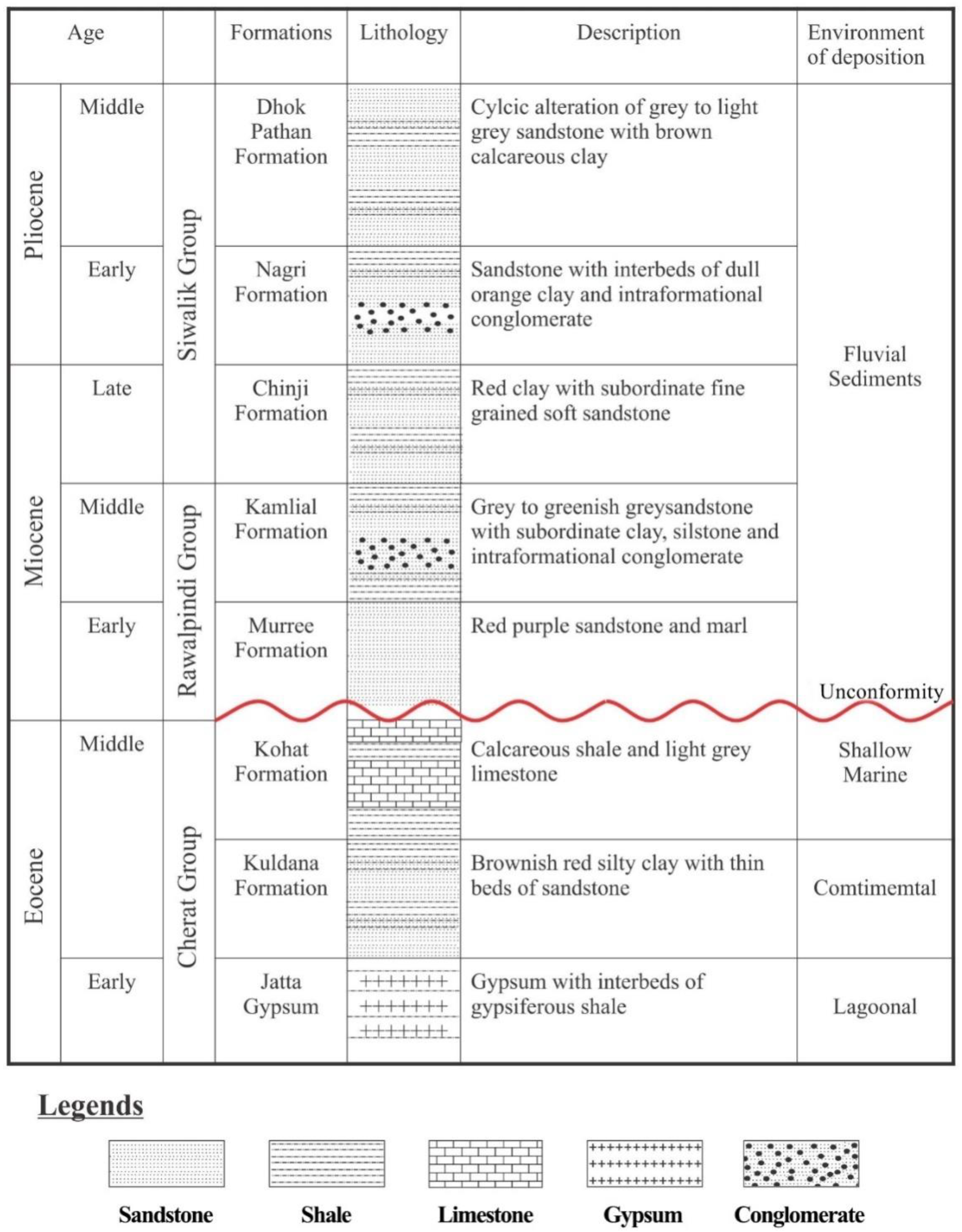
Figure 3.
The geological map of the area modified after Meissner et al. [5]. The red lines (AB, CD, EF, GH, and IJ) are the seismic lines along which 2Deismic data was acquired.
Figure 3.
The geological map of the area modified after Meissner et al. [5]. The red lines (AB, CD, EF, GH, and IJ) are the seismic lines along which 2Deismic data was acquired.
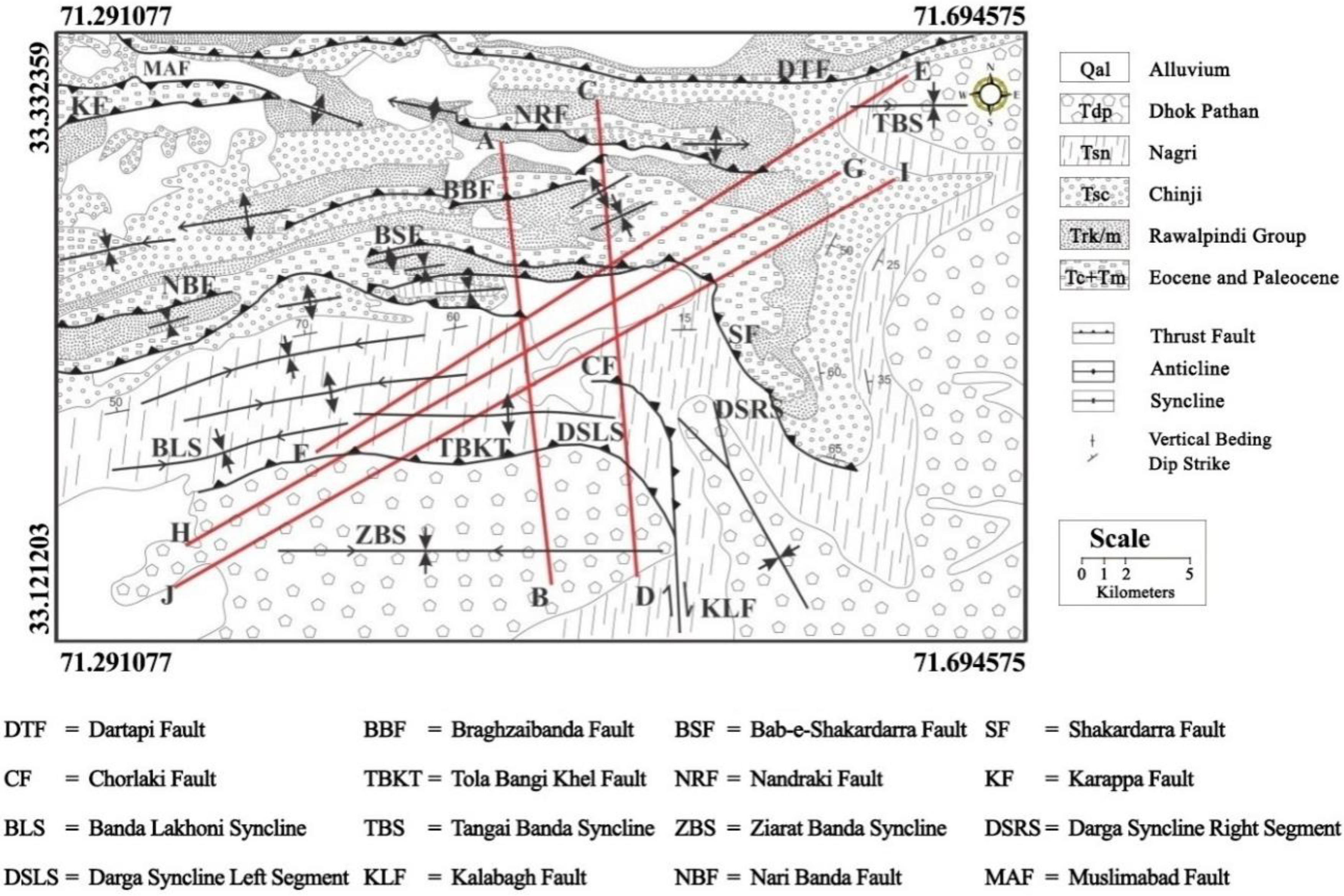
Figure 4.
The Interpreted Geological cross sections along line AB (Line Number 865-NK-15).
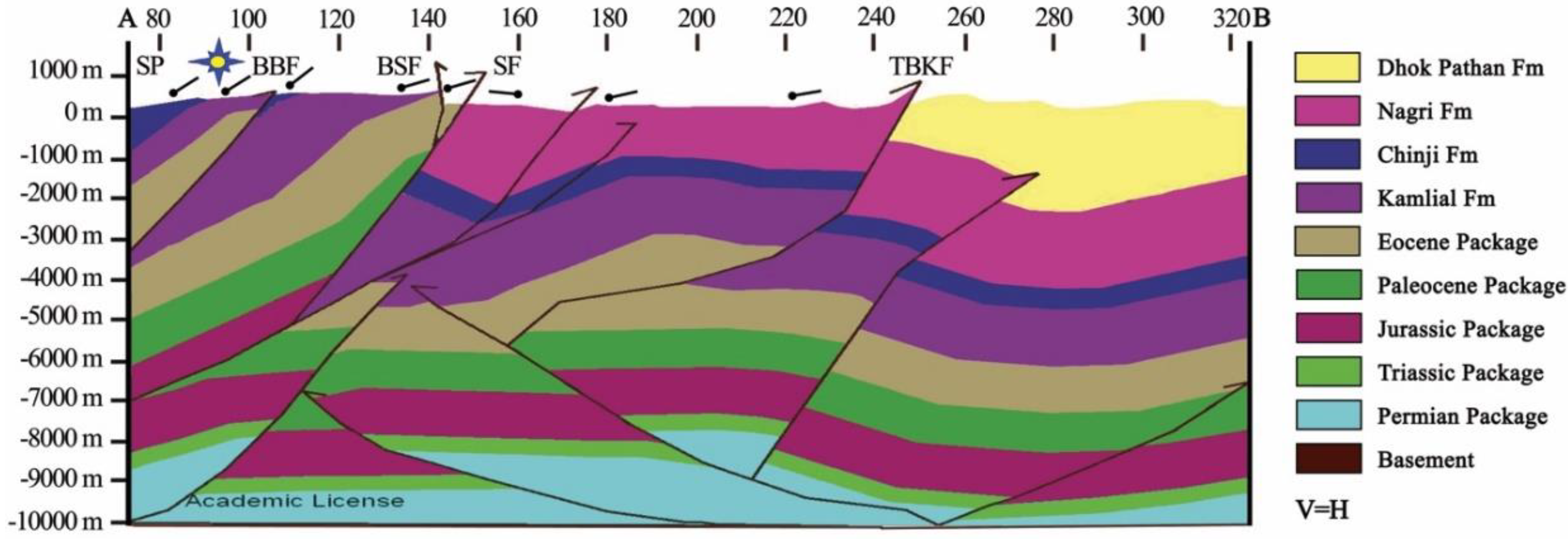
Figure 5.
The Interpreted Geological cross sections along line CD (Line Number 865-NK-08).
Figure 6.
The Interpreted Geological cross sections along line EF (Line Number 865-NK-02).

Figure 7.
The Interpreted Geological cross sections along line GH (Line Number 865-NK-05).
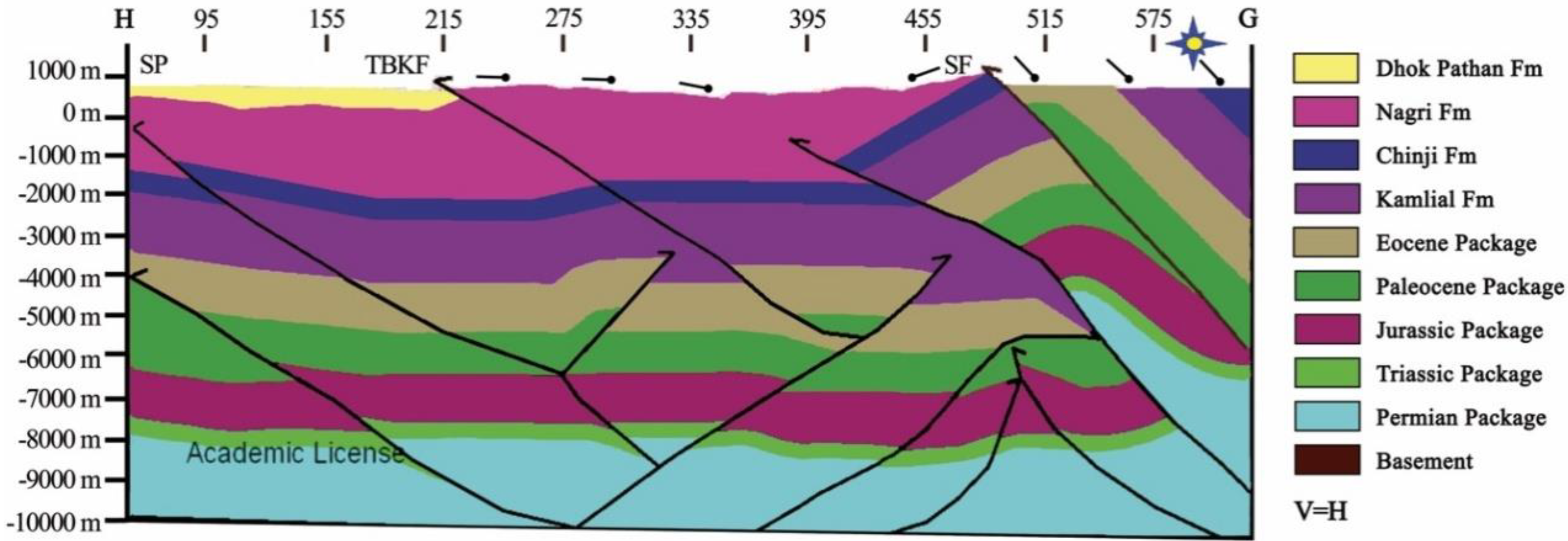
Figure 8.
The Interpreted Geological cross sections along line IJ (Line Number 865-NK-11).
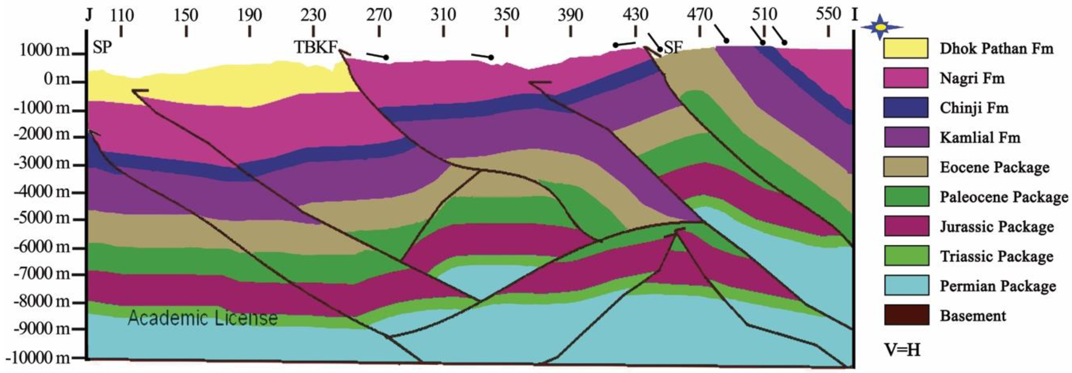
Figure 9.
The thrusts are rotated from EW to NS by the influence of the Kalabagh strike-slip fault (Google maps, 2012. Bahria University: Islamabad Campus, 1:50,000. Google Maps [online] Available through: Bahria University library; https://bahria.edu.pk/libraries [Accessed May 2013].
Figure 9.
The thrusts are rotated from EW to NS by the influence of the Kalabagh strike-slip fault (Google maps, 2012. Bahria University: Islamabad Campus, 1:50,000. Google Maps [online] Available through: Bahria University library; https://bahria.edu.pk/libraries [Accessed May 2013].
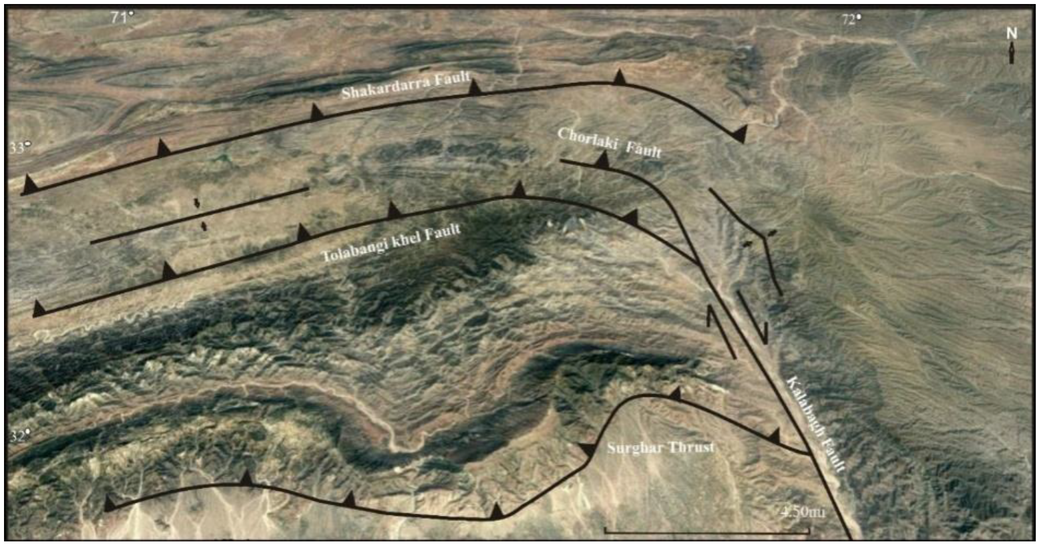
Figure 10.
The three steps showing the development of the folds and the truncation of the folds by faults.
Figure 10.
The three steps showing the development of the folds and the truncation of the folds by faults.
© 2018 by the authors. Licensee MDPI, Basel, Switzerland. This article is an open access article distributed under the terms and conditions of the Creative Commons Attribution (CC BY) license (http://creativecommons.org/licenses/by/4.0/).
Share and Cite
MDPI and ACS Style
Hussain, H.; Zhang, S. Structural Evolution of the Kohat Fold and Thrust Belt in the Shakardarra Area (South Eastern Kohat, Pakistan). Geosciences 2018, 8, 311. https://doi.org/10.3390/geosciences8090311
AMA Style
Hussain H, Zhang S. Structural Evolution of the Kohat Fold and Thrust Belt in the Shakardarra Area (South Eastern Kohat, Pakistan). Geosciences. 2018; 8(9):311. https://doi.org/10.3390/geosciences8090311
Chicago/Turabian StyleHussain, Hamid, and Shuangxi Zhang. 2018. "Structural Evolution of the Kohat Fold and Thrust Belt in the Shakardarra Area (South Eastern Kohat, Pakistan)" Geosciences 8, no. 9: 311. https://doi.org/10.3390/geosciences8090311
Note that from the first issue of 2016, this journal uses article numbers instead of page numbers. See further details here.