Article

Fluid Vents, Flank Instability, and Seafloor Processes along the Submarine Slopes of the Somma-Vesuvius Volcano, Eastern Tyrrhenian Margin

1
Istituto per l’Ambiente Marino Costiero, IAMC-CNR, Calata Porta di Massa, Interno Porto di Napoli, 80133 Naples, Italy
2
Istituto per l’Ambiente Marino Costiero, IAMC-CNR, U.O.S. Capo Granitola, Via del Faro 3, 91021 Campobello di Mazara, Trapani, Italy
3
Istituto Nazionale di Geofisica e Vulcanologia, INGV, Via di Vigna Murata, 605, 00143 Roma, Italy
*
Author to whom correspondence should be addressed.
Geosciences 2018, 8(2), 60; https://doi.org/10.3390/geosciences8020060
Submission received: 16 December 2017 / Revised: 2 February 2018 / Accepted: 5 February 2018 / Published: 8 February 2018

Abstract

:
We report the geomorphological features of the continental shelf of the Gulf of Naples along the submarine slopes of the Somma-Vesuvius volcanic complex. This area is characterized by seafloor morphologies that are related to mantle degassing. Significant phenomena associated with this process occur. Doming of the seafloor has been detected in the area of Banco della Montagna, whereas a hole-like morphology has formed at Bocca dei Pescatori, likely as a result of a phreatic explosion. Outcropping or partially submerged volcanic bodies are also present as well as two main debris avalanche deposits arising from the main Somma-Vesuvius edifice. A large area characterized by an overall concave external profile and a global sediment wave morphology covers most of the southwestern area of the volcano.

1. Introduction

The Gulf of Naples is one of the areas of the Eastern Tyrrhenian margin with the highest natural hazard, being characterized by active seismicity [1,2], natural and human-induced environmental pollution (e.g., [3,4]), coastal and marine slides [5,6], and tsunami [7]. The higher potential hazard factors in this area are in close relation with the emergence of volcanic complexes (Figure 1), such as Ischia and Procida Islands, Phlegrean Fields, and Somma-Vesuvius, as well as with the occurrence of several other submarine volcanic centers. Despite an intensive and long-lived effort for the monitoring of volcanic areas on land, the marine geological, geophysical, and chemical datasets necessary for effective full comprehension of the mechanism controlling the marine potential volcanic hazard are still lacking. Here, we present new marine geology data collected by us on the western, submerged sector of the Somma-Vesuvius volcano, and review the available information by previous studies. The aim of this study is to give a comprehensive geological and volcanological picture of the still poorly known submarine parts of the volcano.
Recent exploration carried out by the Italian Research Council (CNR) on the continental shelf of the Gulf of Naples led to the discovery of several previously unreported submarine volcanic features. Volcanic morphologies and structures are detected and/or reinterpreted in this area including potentially active faults, buried, unmapped volcanic structures, and sedimentary bodies associated with active, massive degassing of the seafloor, which is a sign of potential sprouting volcanism [8]. Integrated multibeam echosounder (MBES) bathymetry, magnetometric profiles, high-resolution seismic reflection data, and Remote Operated Vehicle (ROV) inspections help to establish a better understanding of the geological processes responsible for the coastal hazard, with specific reference to the submerged slopes of the Somma-Vesuvius edifice.
A focus of our research is also the recognition of shallow sub-seafloor structures and seafloor morphologies linked to the underwater dynamics of the peripheral sector of the volcanic complex. Documented features include distal magnetized bodies occurring on the outer submarine slopes of the volcano, seafloor doming coupled with diapir-like morphostructures (pagodas) associated with soft sediment deformation by active degassing, and wavy bedforms [9] resulting from extensive seafloor instability along the submerged slopes. Particularly, we discuss the origin of the “Bocca dei Pescatori” (Fisherman’s hole), a sharp, relatively deep semicircular depression located in the proximity of the Somma-Vesuvius coast. This negative seafloor structure is actually reported in the official marine cartography but has never been described, so far, in the scientific literature. Owing to the high anthropization of the coastal sector of the Gulf of Naples (Figure 1) and the consequent exposure of the whole area to the volcanic risk (over 1 million people live in this region), the importance of an improved understanding of marine volcanism appears to be mandatory. Additionally, a better understanding of the local volcanism would also be beneficial for effective planning of monitoring activity.

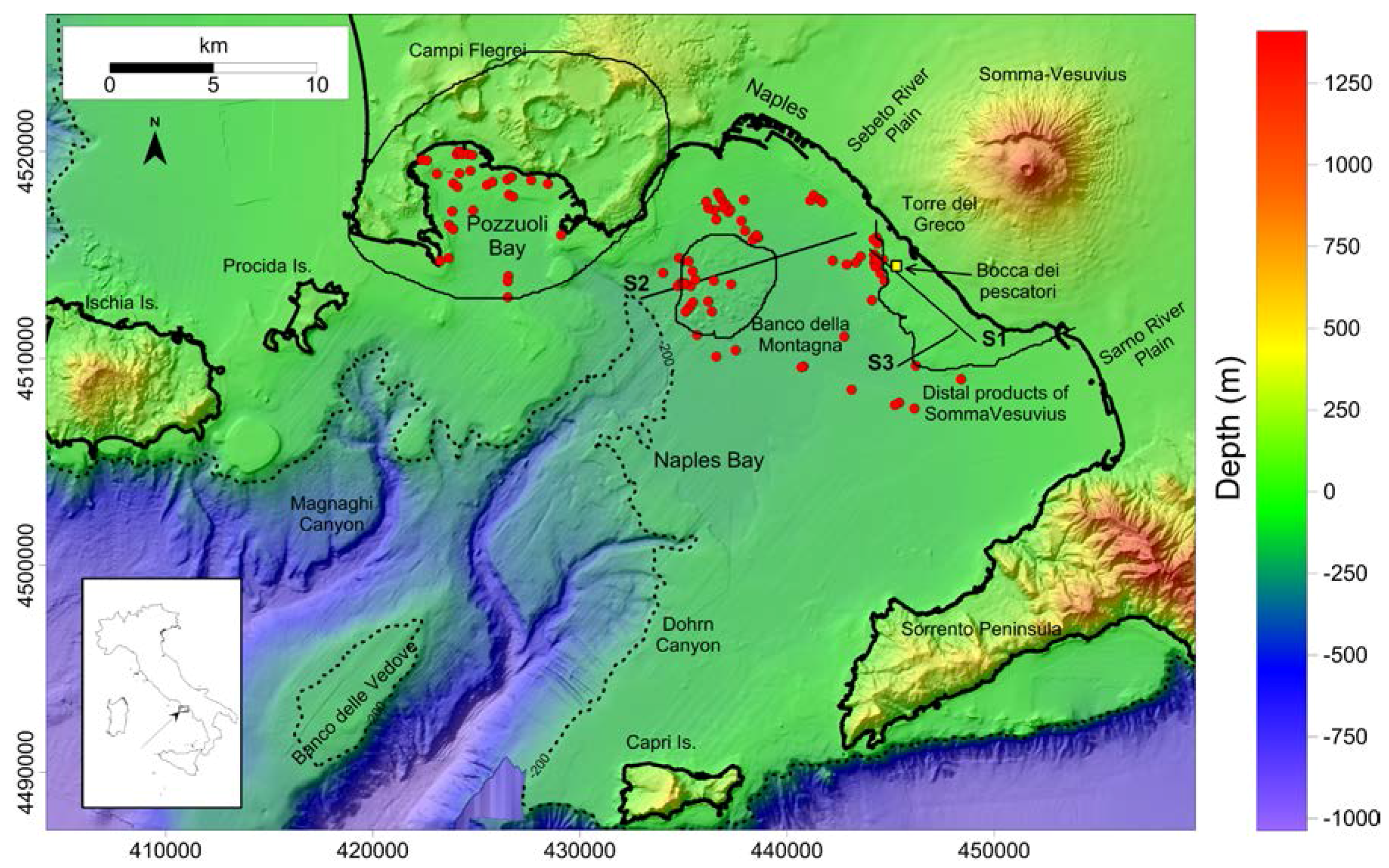
2. Geological Background

The Campania volcanic district includes the active volcanoes of Ischia, Phlegrean Fields, and Somma-Vesuvius (Figure 1), along with Procida Island and a series submarine volcanoes, aligned along a WNW–ESE direction. The pattern of volcanic centers has been interpreted as the result of magma ascent along an E–W lithospheric discontinuity separating the central sector from the southern sector of the Tyrrhenian basin (e.g., [10] and references therein). Volcanic activity in the area emplaced throughout a range of eruptive mechanisms, including magmatic, phreatomagmatic, and caldera forming eruptions ([11], and references therein). Volcanic products of the last ca. 350 ka display an overall alkaline-potassic composition. The last eruptions occurred at Ischia in 1302 AD [12], Phlegrean Fields in 1538 AD [13], and Somma-Vesuvius in 1944 AD [14].
Somma–Vesuvius volcanic complex is formed by the superimposition of two edifices, i.e., the older Mount Somma with a summit caldera and the younger Vesuvius cone. Mount Somma-Vesuvius is a 1321 m high, strongly asymmetric, polygenic volcano. Its morphostructure results from the combined action of NW–SE faulting and large caldera collapses occurred about 18 and 79 AD [15].
Several oceanographic cruises investigated the continental shelf-slope system of the Gulf of Naples during the last 20 years, mainly focusing on seismic-stratigraphic analysis and geological calibration of geophysical datasets by gravity core data. Since 1997, relatively low-resolution (20 m grid cell) Multibeam echosounder (MBES) surveys [16,17] are also available. From 2014, new MBES surveys have been collected on the continental shelf of coastal region and in the Gulf of Naples, with grid cell size resolution varying from 5 m (deeper sectors) to 1 m [18].
The continental shelf off the Somma-Vesuvius is characterized by a hundred meters-thick Upper Pleistocene siliciclastic succession interbedded with volcaniclastic deposits, including ignimbritic units and tephra layers [19,20]. The seabed morphology of the area displays a clear interference between volcanism and the structural pattern of the area, as suggested by the presence of a NNW–SSE trending fault identified on the basis of seismic stratigraphic studies (e.g., [21]). The inner shelf sectors of the Gulf of Naples are characterized by the occurrence of several volcanic structures revealed by magnetic anomalies [22]. Some of these features display high intensity, short-wavelength magnetic anomalies associated with a structurally controlled, NW–SE alignment of dome-like structures [23].
Another volcanic feature younger than 19 ka (perhaps emplaced in historical times) has been recognized by Siniscalchi et al. [24] along the submerged flanks of the Somma-Vesuvius complex, nearby the coast of Torre del Greco. These features are interpreted as buried and/or outcropping dome-like structures and dike-like bodies [25]. Over the entire area, degassing areas occur along main tectonic lineaments [26]. Chemical analyses show that fluids emissions documented on the continental shelf are composed of volcanic CO2 rising up from the mantle with a low crustal component [8]. The southern sector is occupied by the Sarno River plain on land and by its offshore prosecution [19] characterized by intercalations of siliciclastic sediments and volcaniclastic products from several eruptions over the last thousand years [27].
Offshore from Torre del Greco village (Figure 1), a deep hole, located in proximity of the coast, known as the “Bocca dei Pescatori” (BdP) has been detected. The presence of such a negative seafloor morphology has been reported by fishermen and included in the official cartography. This feature is commonly reported in marine charts as a sharp hole characterized by steep walls, with the lowest point ca. 15 m deeper with respect to the surrounding seafloor.

3. Data and Methods

All data were acquired IAMC-CNR, Naples geophysical laboratory during several research cruises, onboard the CNR research vessels Urania and Minerva Uno. Multibeam data processing was carried out with Reson-Thales PDS2000© software (version 3.8.1.4), following Internaional Hydrographic Organization standards (IHO, [28]). Processing included removal of navigation errors, noise reduction, i.e., de-spiking, removal of poor quality beams, and tidal and sound velocity corrections (e.g., [29]). During data processing, depth measurements are partially re-organized in a regular matrix (Digital Terrain Model; DTM). The average resolution of a DTM derived from MBES may depend on several parameters, including: (a) water-depth range of the survey area, (b) number of beams, (c) Sound Velocity Profile (SVP) accuracy, (d) instrumental frequency and positioning system that was used. Vertical resolution is mostly controlled by the instrumental frequency, whereas horizontal resolution depends mainly on the “footprint” (i.e., the number of beams per square unit as a function of water-depth). As a result of the final processing steps, a 1 m cell-size grid is produced for the detailed study of selected areas, i.e., Banco della Montagna and Bocca dei Pescatori, whereas a 10 m grid cell Digital Terrain Model is adopted for the surrounding shelf region.
Ultra-high-resolution reflection seismic data were recorded with a Chirp II (Benthos© Inc., Falmouth, MA, USA) sub-bottom profiler that operates with 16 transducers in a wide frequency band (2–7 kHz) with a chirp pulse of 20–30 ms. Sparker profiles were acquired with a 1 kJ multi-tip source. Signal penetration was found to exceed 90 ms two-way time. The system is characterized by a vertical resolution of ca. 25 cm. Penetration of the acoustic signal can be in the order of more than 200 m in deep water soft sediments. Data were processed and displayed by using Geosuite Allworks software, with swell correction, 2–6 Khz band-pass IIR filtering, and Automatic Gain Control (AGC). ROV visual inspections were obtained by using a Pollux III (GEI, Global Electric Italia Srl, Barga, Lucca, Italy) ROV system equipped with manipulators, positioning systems, high-definition camcorders and sonar, suitable for surveys down to a depth of ≈600 m below sea level (hereafter bsl).

4. Results and Discussion

4.1. General Morphology

The final marine DTM (Figure 2A) covers an elevation range between −1400 and −900 m and an area of more than 865 km2, part of which (ca. 375 km2) derives from ultra-high-resolution bathymetric data mainly acquired during the SAFE_2014 oceanographic cruise. Slopes range from 0° to 77°, mostly showing low values (0.9° for the median values, 1.8° for the 75% percentile) representative of inner shelf areas. The seafloor morphology shows the deformation front of the W-SW sector of Somma-Vesuvius slope (Figure 2, P1–P4), which is mainly shaped by the interaction of lateral collapses, also including debris avalanches [30,31], lava flows, and pyroclastic flow deposits reworked by sea-level fluctuations. Lava flows were interpreted as the product of Middle Age eruptions entering the sea [25].
Seafloor morphologies are well visible by using elevation profiles extracted by the DTM (Figure 2A). Profile P1 shows the presence of stepped terraces and slope breaks due to the rapid cooling of lavas and/or volcaniclastic deposits, as well as the present-day inner-shelf abrasion surface (Figure 2B, P1). Profile P2 is extracted over the distal sector of a wavy seafloor morphology (Figure 2B, P2), while southward (Figure 2B, P3) the DTM shows the occurrence of a small valley, probably incised by the Sarno river mouth during the Last Glacial Maximum (LGM) [32]. Profile P4 is located over the distal part of an inferred pyroclastic flow deposit [33]. All of the described slopes show an overall convex morphology, whereas P5 is almost linear, likely due to the presence of a paleo-thalweg segment of Sarno River along the profile (Figure 2C, P5). Southward of the overall morphology, the shelf is mostly controlled by a base level of erosion in equilibrium with the sea level lowstand during the LGM and by the evolution of the Sorrento Peninsula (Figure 1 and Figure 2C, P6).
The high-resolution multibeam bathymetry reveals that the Bocca dei Pescatori (Figure 3) is a ca. 30 m large and 40 m deep semi-circular depression. The lowest elevation at the bottom of BdP is −91 m bsl with respect to the surrounding seafloor at ca. −50 m. The SW flank of BdP depression is extremely sloping (almost vertical), whereas its northern margin is characterized by the presence of several morphological steps, presumably due to slope instability or small slides inside the main depression (Figure 3A,B, P1). The apical rim of BdP displays a slight upward convexity (Figure 4). Although the inner walls of the depression are very steep (about 80° in the apical portion), materials deposited on the slopes are covered by incoherent fouling of algae and sediments.
Banco della Montagna (BdM) is a hummocky region of the seafloor surface and is visible in the westernmost frame of the acquisition area, ca. 6 km SE off Posillipo hill. This bank was emplaced by the dragging and rising up of previously stratified volcaniclastic sediments (Figure 5) [17] as a consequence of the overpressure associated with the emergence of active fluid vents in the area [8,34].

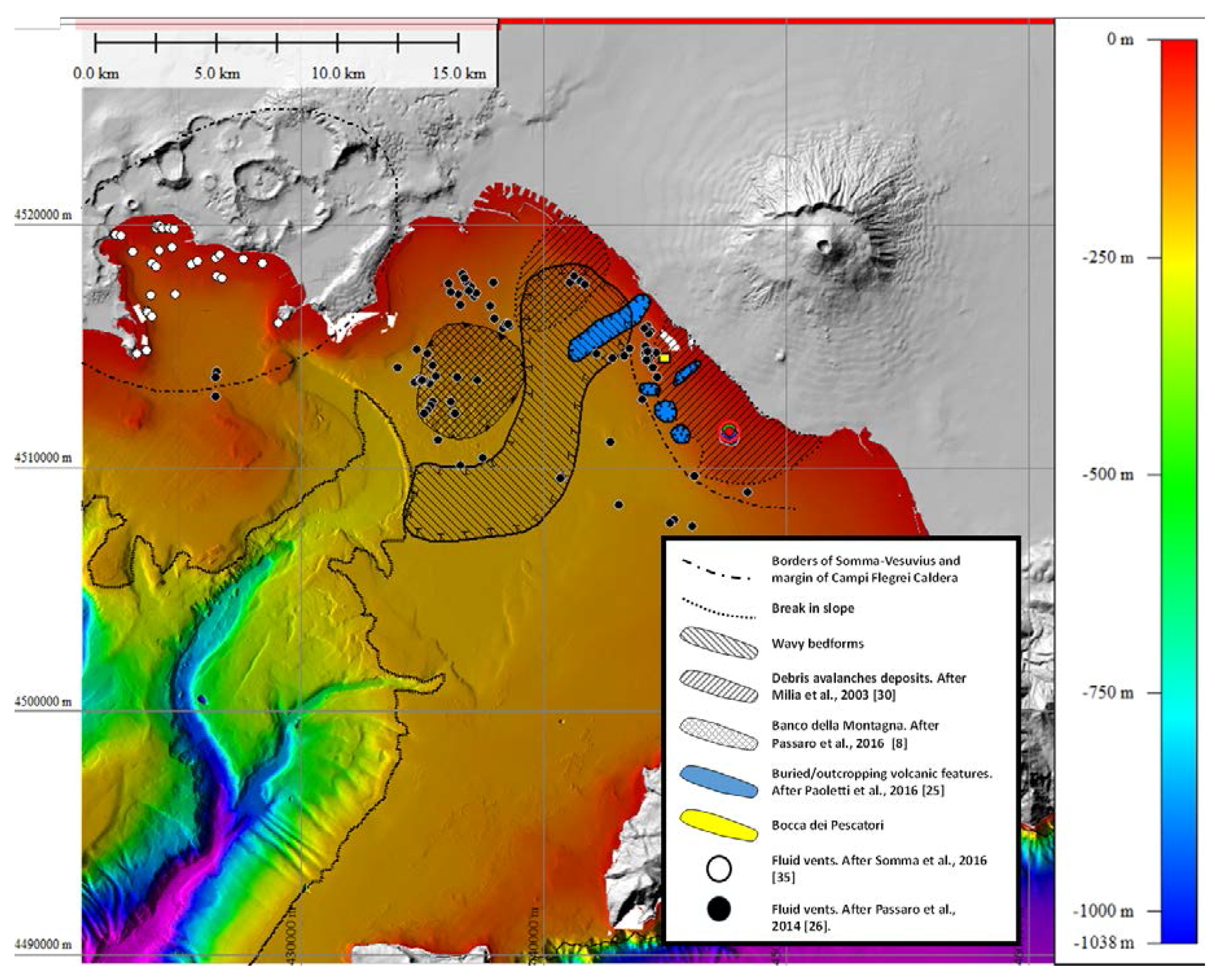
4.2. Seafloor Bedforms

Several volcanic features characterize the continental shelf of the Naples Bay, and in particular the sectors off the Somma-Vesuvius edifice. Despite the occurrence of a N140° E fault controlling the structure of the coastal area [15], the main volcanic edifice extends its slopes from the subaerial environment to the shallow marine area. The interaction between volcanism and sedimentary processes locally produced a variety of seafloor morphologies including: (1) wavy bedforms; (2) buried and outcropping volcanic features; (3) depositional bodies due to potential lateral collapses; (4) degassing features and associated soft-sediment deformation structures.

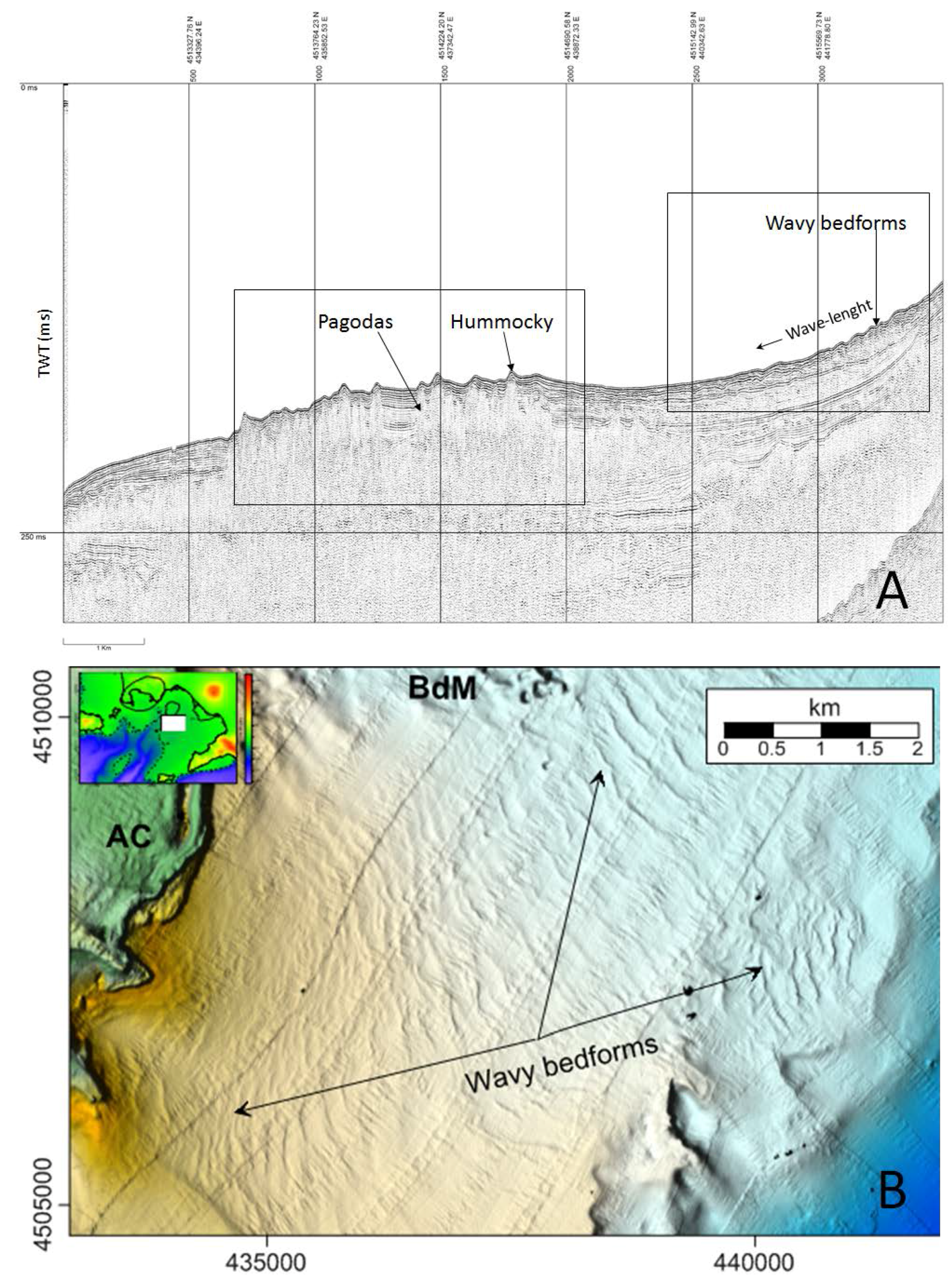
4.2.1. Wavy Bedforms

From the NW coastline segment, east of the Naples Harbor to the distal, marine sector of Somma-Vesuvius edifice, the seafloor displays a globally concave morphology and diffuse wavy bedforms (Figure 5A,B). This feature extends between BdM and Somma-Vesuvius marine products toward west and east, respectively. Such wavy seafloor morphology abruptly terminates in correspondence of the Ammontatura Channel (Figure 5B), a curved canyon branch that links the westernmost sector of Campi Flegrei to the uppermost part of Magnaghi Canyon. The wavy bedforms sector covers an area of about 50 km2. It displays a width of ca. 3500 m along the isobaths and extends for ca. 130 m down-slope, on average, with an overall increasing wavelength towards distal sectors.
Typically, wavy bedforms develop: (i) in areas subjected to generalized slope instability characterized by creep, sliding, and slump folding, (ii) in association with tractive currents acting at the seafloor, or (iii) in the presence of massive degassing that causes rise up and cause deformation of unconsolidated sediments. We cannot exclude the possibility that different mechanisms explaining the formation of wavy bedforms may coexist in the same area.

4.2.2. Buried and Outcropping Volcanic Features

According to Secomandi et al. [23] and Paoletti et al. [25], the continental shelf off the Somma-Vesuvius volcano is characterized by the occurrence of several buried or surficial volcanic structures. Outcropping features correspond to minor volcanic centers and/or to lava flows entering the sea. Seismic profiles clearly image the distal boundary of the Somma-Vesuvius volcanic complex, which is likely the result of lava flows and pyroclastic flow deposits that entered the sea during the Middle Age (Figure 6 and Figure 7) [25].
High-resolution seismic profiles (Figure 7) allow for the detailed interpretation of the transgressive and/or high stand deposits that formed after the onset of LGM [25] (ca. 19 ka). The post-LGM (PLMG) succession is characterized by frequent tephra layers (dark reflectors) intercalated with reworked deposits deriving from lateral collapses (“whitened” reflectors) [9,15,30]. Main bedrock contacts located below the PLGM show indented or sharp margins, thus allowing discrimination of volcanic/volcaniclastic deposits from the sedimentary basement. Four main volcanic bodies are visible in the seismic profile, showing edges that match well with the residual magnetic anomalies. This area is located in the distal sector of the volcano, where the buried substratum should be completely covered by the products of volcanic eruptions occurred between the 79 AD and the 16th century.

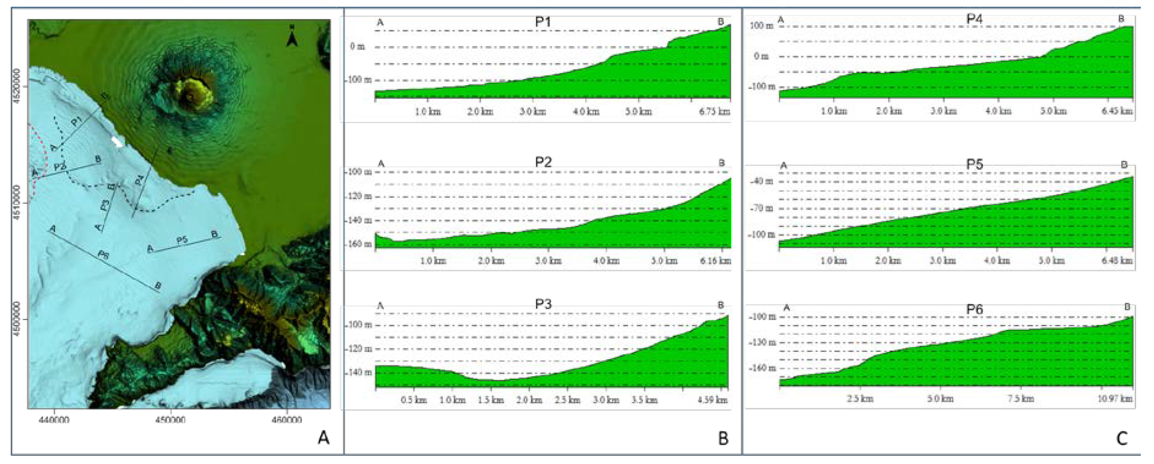
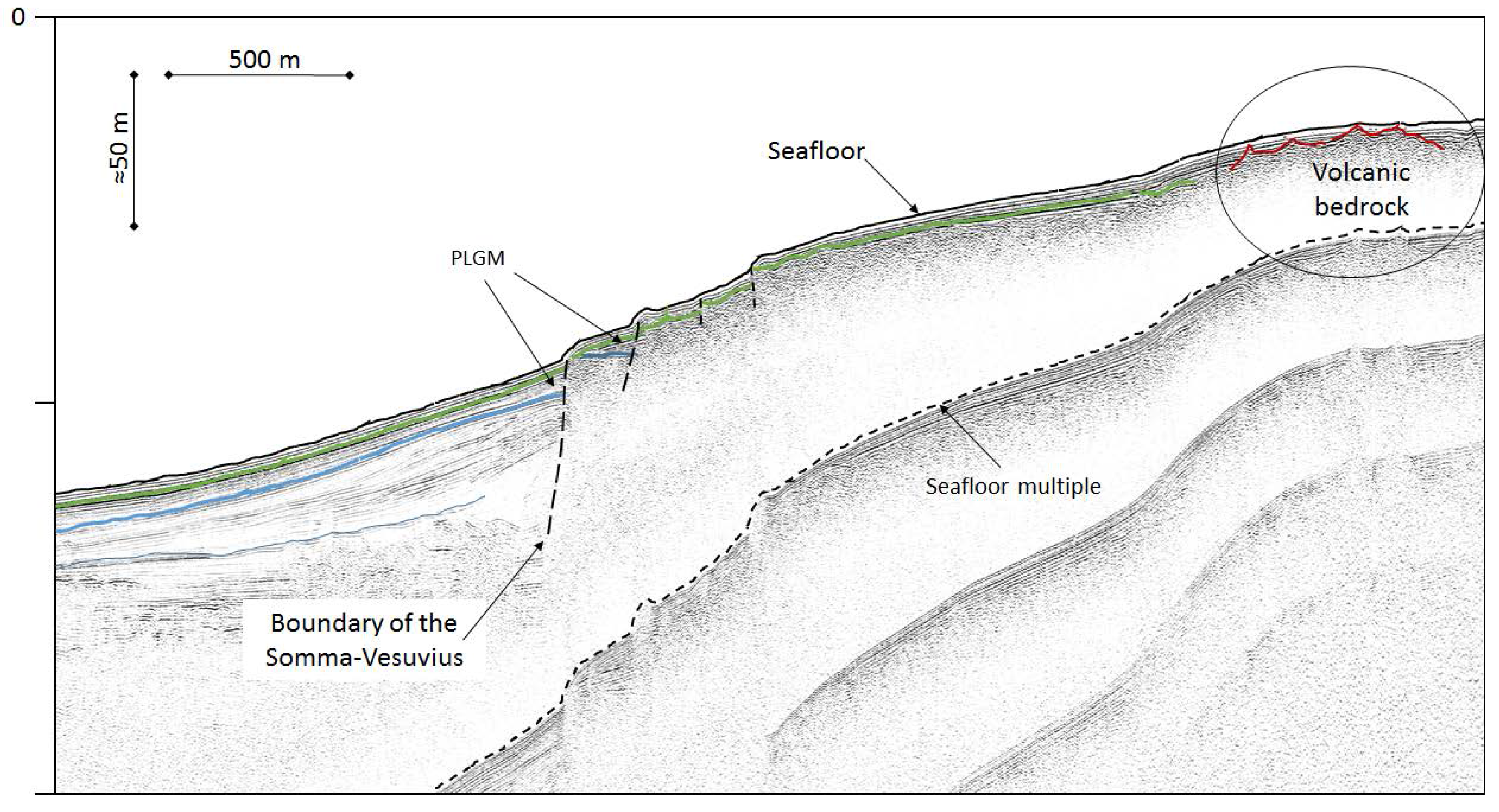
4.2.3. Depositional Bodies due to Potential Lateral Collapses

The uppermost part of the stratigraphic succession shows that the seaward extension of Somma-Vesuvius forms a fan-shaped structure. In addition to lava flows and pyroclastic flow deposits, two main lateral collapses have also been documented (Figure 6). The first lateral collapse is dated at 18 ka BP [15,30] and occupies a large sector between the Sarno River Plain and the Somma-Vesuvius. The second deposit is emplaced between the Sebeto River Plain and Somma-Vesuvius, and it is dated about 3.5 ka BP. In the central sector, the occurrence of a series of pyroclastic flow units generated by the Plinian eruption that destroyed Pompei and Ercolano (79 AD) has been documented [9]. It was also proposed that the pyroclastic flow deposits entering the seawater during the 79 AD eruption generated a tsunami in Naples Bay [9].

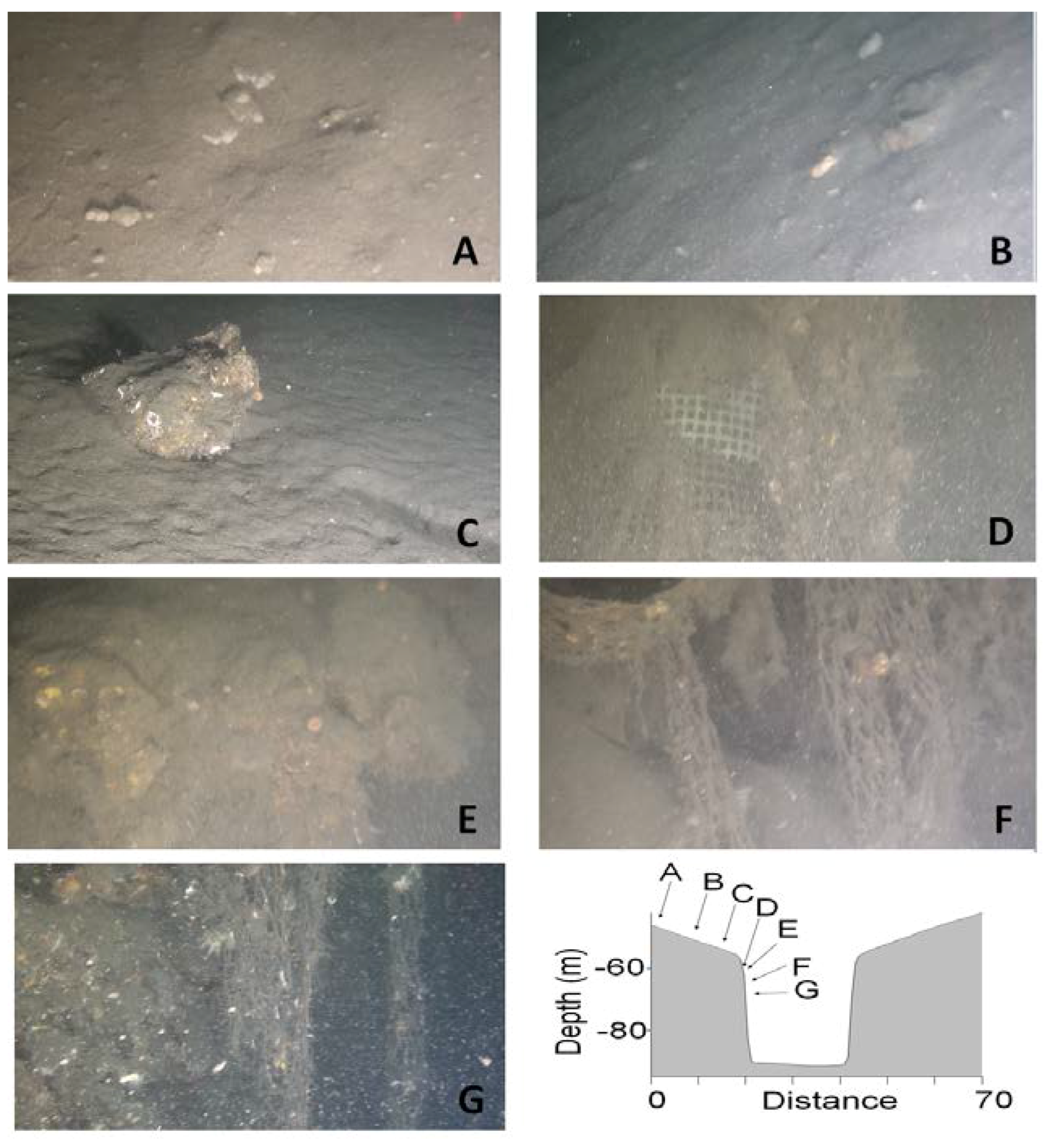
4.2.4. Degassing Features and Associated Soft-Sediment Deformation Structures

In Naples Bay, a large number of active fluid vents were discovered. To date, about 76 active fluid vents from the seafloor have been surveyed in Naples Bay [26], while 31 have been surveyed in Pozzuoli Bay [35] (Figure 1 and Figure 6). As a consequence, a large number of seafloor morphologies produced by gas vents can be found, including pockmarks, cones, and elongated features. Passaro et al. [8] have recently reported that fluid vents are particularly concentrated over an area extending ca. 25 km2, with a height of about 25 m with respect to the surrounding seafloor. This structure, known as Banco della Montagna (BdM), shapes a sub-circular swelling of the seafloor located at ca. 5 km SW of the Napoli harbor in the marine area between Campi Flegrei and Somma-Vesuvius, at 120 m below the sea level (Figure 6). BdM is characterized by a hummocky-like morphology consisting of mounds, meter-sized cones, and pockmarks resulting from the upraising and active emissions of CO2-rich gas. The gas composition is comparable with that of the Campi Flegrei and Somma-Vesuvius fumaroles and it is indicative of a mixing between a mantle source and shallower fluids associated with partial decarbonation of crustal rocks. BdM discharged fluids, which ascend along vertical conduits with diameters between 50 and 200 m, do not alter the physical and chemical features of the surrounding seawater, except for pH, which displays more acid conditions above the gas emissions. The upraising of gas within sub-seafloor deposits produces diapiric-like structures known as ‘pagodas’ (Figure 5). The deformation of sediments related to the onset and evolution of ‘pagoda’ structures include folding and faulting of the underlying sediments. As a result, a non-magmatic unrest characterized by active, low-temperature degassing processes and deformation affects the Gulf of Napoli [34]. Nevertheless, possible future increase in temperature of fluid vents and/or the occurrence of local seismicity may be signs of a change in the dynamics of BdM, which requires accurate monitoring. The active gas discharge and deformation recognized in the Gulf of Naples may potentially evolve into magmatic unrest.

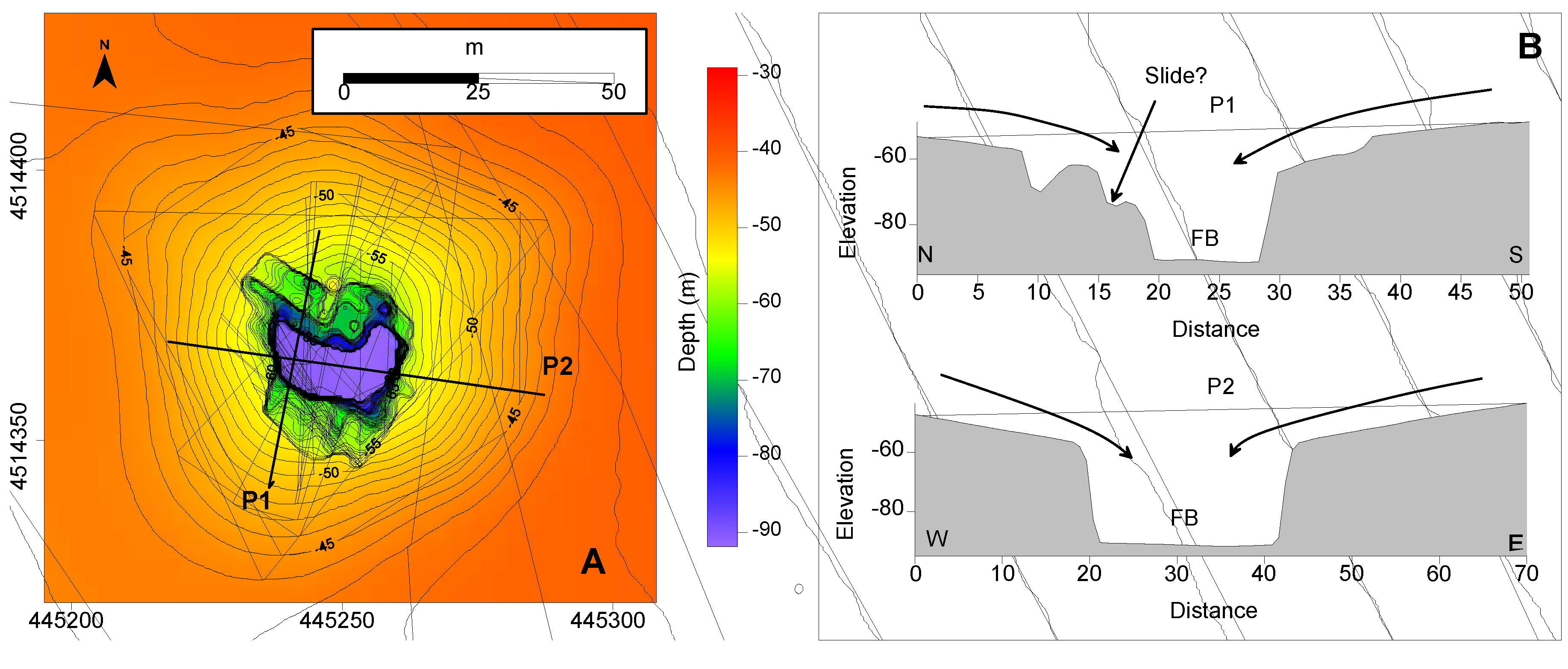
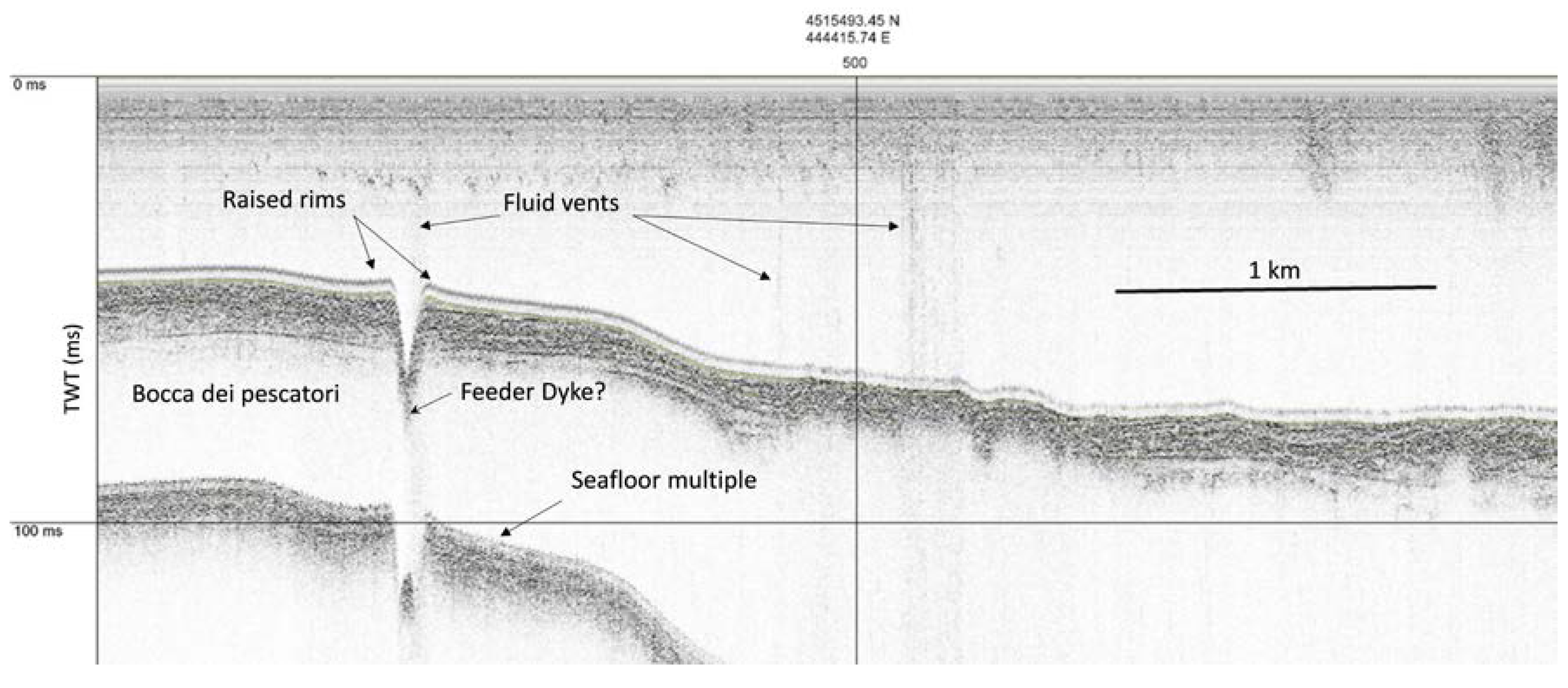
4.2.5. Bocca dei Pescatori: Maar or Sinkhole?

BdP (Figure 1 and Figure 3) is a sharp negative morphology located at about 1 km from Torre del Greco harbor, at a depth of about −45 m bsl. The depression is about 30 m large and 50 m deep at the lowest point (−91 m bsl) with respect to the surrounding seafloor (Figure 3A). The southwest side of BdP is extremely sloping (almost vertical), while its north margin is characterized by the presence of several stepped features, presumably due to a local collapse or a small slide inside the main hollow body of the depression itself (Figure 3A,B, P1). The apical shape of the BdP rim is slightly convex (Figure 4 and Figure 8A–C). ROV images detected inside the BdP are rather difficult to interpret, as they document that the rims of the structure are largely covered by anthropic waste (e.g., fishnets, fish traps) that almost completely masks the upper part of the inner slopes (Figure 8D–G). Although the walls are very steep (about 80° in the apical portion), materials deposited on the slopes are completely covered by incoherent fouling of algae and sediments. These morphostructures can be either explained as the results of vertical collapse associated with sink-hole like morphology, or explosive activity that partially empties the inner structural depression by ejection of volcanic material. Sinkholes are typical of karstic landscapes dominated by dissolution of carbonate rocks [36] or evaporites (usually at larger scale) [37], but very similar features may also develop in volcanic areas as a consequence of vertical collapse of volcaniclastic deposits due to archways backdown in lava tubes. BdP is located on the flanks of the Somma-Vesuvius complex and its formation is presumably related to volcanic processes.
Particularly, a number of features, including: (a) the elevated steepness of its inner walls, (b) the ratio between the height of the depression (about 50 m for the exposed section) and its maximum width (30 m), and (c) the convex-upward morphology of the rims in the apical section (Figure 4 and Figure 8A–C) suggest that the BdP may be interpreted as a collapse feature resulting from an explosion accompanied by huge degassing. The overall crater morphology of the BdP is similar to that of typical of maars [38], i.e., low-relief volcanic craters caused by phreatomagmatic eruptions. Although a crater rim is well defined, no clear evidences of a funnel-like geometry, which is typical of maar-diatreme structure, can be recognized. However, recent experiments on maar-diatreme development show that sub-vertical hole structures with steep slopes may form when the maar originated by a single blast event at depth [39]. Therefore, the BdP geometry, which is consistent with that obtained by experimental models, may reflect a single, deep, blast-like event. In addition, while subaerial maars are commonly filled by the fallback of ejected materials, those formed in submarine environment may not be re-filled because the ejecta are delivered in the water column, where, because of the low settling velocity, they may be dispersed away from the crater area by local sea currents [40]. Although further studies on the nature of the sub-seafloor deposits at the bottom of the BdP may provide further constraints to understand the nature of this volcanic feature, the BdP morphology is consistent with that of a maar-diatreme.

5. Conclusions

The discovery of fluid vents located on the continental shelf off the Somma-Vesuvius volcanic complex, as well as radial vents on the distal sectors of its submarine slopes in Naples Bay, represents a new contribution towards the understanding of the evolution of this active segment of the eastern Tyrrhenian Margin.
The results of this study suggest that in this area, (a) wavy beds form due to seafloor slope instability, (b) morpho-structures associated with doming effect actually deforming the seafloor, and (c) collapse features associated with potential explosive volcanism may co-exist, as a series of phenomena associated with recent or active degassing of magmatic sources at depth. Buried or locally outcropping volcanic facies are also present, as well as large areas characterized by hummocky morphologies as a result of soft-sediment deformation induced by gas vents.
Due to its proximity to the coastline and taking into consideration the high population density as well as the large number of manufacturing plants and forms of infrastructures, we suggest the continental shelf of the Naples Bay including the submarine slopes of the Somma-Vesuvius volcanic complex should be included in the volcano monitoring program for its severe potential hazard, with specific reference to the Bocca dei Pescatori and Banco della Montagna degassing areas.

Acknowledgments

We thank two anonymous reviewers for comments that helped to improve an early version of the manuscript. Emanuele Gentile and the whole crew of the R/V Urania are thanked for their precious and professional work. Special thanks goes to Giuseppe Magnifico (CNR) for his essential support and great efforts during all of the CNR oceanographic cruises.

Author Contributions

Salvatore Passaro and Guido Ventura interpreted data results. Salvatore Passaro, Marco Sacchi, Stella Tamburrino and Guido Ventura acquired, processed data and wrote the paper.

Conflicts of Interest

The authors declare no conflict of interest.

References

  1. Del Pezzo, E.; Bianco, F.; Saccorotti, G. Seismic source dynamics at Vesuvius volcano, Italy. J. Volcanol. Geotherm. Res. 2004, 133, 23–39. [Google Scholar] [CrossRef]
  2. Saccorotti, G.; Petrosino, S.; Bianco, F.; Castellano, M.; Galluzzo, D.; La Rocca, M.; Del Pezzo, E.; Zaccarelli, L.; Cusano, P. Seismicity associated with the 2004–2006 renewed ground uplift at Campi Flegrei Caldera, Italy. Phys. Earth Planet. Inter. 2007, 165, 14–24. [Google Scholar] [CrossRef] [Green Version]
  3. Albanese, S.; De Vivo, B.; Lima, A.; Cicchella, D.; Civitillo, D.; Cosenza, A. Geochemical baselines and risk assessment of the Bagnoli brownfield site coastal sea sediments (Naples, Italy). J. Geochem. Explor. 2010, 105, 19–33. [Google Scholar] [CrossRef]
  4. Menghan, W.; Stefano, A.; Annamaria, L.; Cannatelli, C.; Cosenza, A.; Lu, W.; Sacchi, M.; Doherty, A.; De Vivo, B. Compositional analysis and pollution impact assessment: A case study in the Gulfs of Naples and Salerno. Estuar. Coast. Shelf Sci. 2015, 160, 22–32. [Google Scholar] [CrossRef]
  5. Matano, F.; Pignalosa, A.; Marino, E.; Esposito, G.; Caccavale, M.; Caputo, T.; Sacchi, M.; Somma, R.; Troise, C.; De Natale, G. Laser scanning application for geostructural analysis of tuffaceous coastal cliffs: The case of Punta Epitaffio, Pozzuoli Bay, Italy. Eur. J. Remote Sens. 2105, 48, 615–637. [Google Scholar] [CrossRef]
  6. Caccavale, M.; Matano, F.; Sacchi, M. An integrated approach to earthquake-induced landslide hazard zoning based on probabilistic seismic scenario for Phlegrean Islands (Ischia, Procida and Vivara), Italy. Geomorphology 2017, 295, 235–259. [Google Scholar] [CrossRef]
  7. Tinti, S.; Pagnoni, G.; Piatanesi, A. Simulation of tsunamis induced by volcanic activity in the Gulf of Naples (Italy). Nat. Hazards Earth Syst. Sci. 2003, 3, 311–320. [Google Scholar] [CrossRef]
  8. Passaro, S.; Tamburrino, S.; Vallefuoco, M.; Tassi, F.; Vaselli, O.; Giannini, L.; Chiodini, G.; Caliro, S.; Sacchi, M.; Luca Rizzo, A.; et al. Seafloor doming driven by degassing processes unveils sprouting volcanism in coastal areas. Sci. Rep. 2016, 6, 22448. [Google Scholar] [CrossRef] [PubMed]
  9. Milia, A.; Molisso, F.; Raspini, A.; Sacchi, M.; Torrente, M.M. Syn-eruptive features and sedimentary processes associated with pyroclastic currents entering the sea: The 79 AD eruption of Vesuvius, Naples Bay, Italy. J. Geol. Soc. 2008, 165, 839–848. [Google Scholar] [CrossRef]
  10. Piochi, M.; Bruno, P.P.; De Astis, G. Relative roles of rifting tectonics and magma ascent processes: Inferences fromgeophysical, structural, volcanological, and geochemical data for the Neapolitan volcanic region (southern Italy). Geochem. Geophys. Geosyst. 2005, 6. [Google Scholar] [CrossRef]
  11. Orsi, G.; Di Vito, M.A.; Isaia, R. Volcanic hazard assessment at the restless Campi Flegrei caldera. Bull. Volcanol. 2006, 66, 514–530. [Google Scholar] [CrossRef]
  12. Vezzoli, L. Island of Ischia. In Quaderni della “Ricerca Scientifica”; Consiglio Nazionale delle Ricerche (CNR): Roma, Italy, 1988. [Google Scholar]
  13. Di Vito, M.; Lirer, L.; Mastrolorenzo, G.; Rolandi, G. The 1538 Monte Nuovo eruption (Campi Flegrei, Italy). Bull. Volcanol. 1987, 49, 608–615. [Google Scholar] [CrossRef]
  14. Santacroce, R.; Cioni, R.; Marianelli, P.; Sbrana, A.; Sulpizio, R.; Zanchetta, G.; Donahue, D.J.; Joron, J.L. Age and whole rock-glass compositions of proximal pyroclastics from the major explosive eruptions of Mt. Somma-Vesuvius: A review as a tool for distal tephrostratigraphy. J. Volcanol. Geotherm. Res. 2008, 177, 1–18. [Google Scholar] [CrossRef]
  15. Milia, A.; Torrente, M.M.; Bellucci, F. A possible link between faulting, cryptodomes and lateral collapses at Vesuvius Volcano (Italy). Glob. Planet. Chang. 2012, 90, 121–134. [Google Scholar] [CrossRef]
  16. Aiello, G.; Budillon, F.; Cristofalo, G.; D’Argenio, B.; de Alteriis, G.; De Lauro, M.; Ferraro, L.; Marsella, E.; Pelosi, N.; Sacchi, M.; et al. Marine geology and morphobathymetry in the Bay on Naples (South-Eastern Tyrrhenian Sea, Italy). In Mediterranean Ecosystems: Structures and Processes; Faranda, F.M., Guglielmo, L., Spezie, G., Eds.; Springer: Milan, Italy, 2001; pp. 1–8. [Google Scholar]
  17. D’Argenio, B.; Angelino, A.; Aiello, G.; de Alteriis, G.; Milia, A.; Sacchi, M.; Tonielli, R.; Budillon, F.; Chiocci, F.; Conforti, A.; et al. Digital elevation model of the Naples bay and adjacent areas, eastern Tyrrhenian Sea. In Mapping Geology in Italy; Paquaré, G., Venturini, C., Groppelli, G., Eds.; APAT-SELCA: Florence, Italy, 2004; pp. 21–28. [Google Scholar]
  18. Passaro, S.; Tamburrino, S.; Vallefuoco, M.; Gherardi, S.; Sacchi, M.; Ventura, G. High-resolution morpho-bathymetry of the Gulf of Naples (scale 1:50.000), Eastern Tyrrhenian Sea. J. Maps 2016, 12, 203–210. [Google Scholar] [CrossRef]
  19. Sacchi, M.; Insinga, D.; Milia, A.; Molisso, F.; Raspini, A.; Torrente, M.M.; Conforti, A. Stratigraphic signature of the Vesuvius 79 AD event off the Sarno prodelta system, Naples Bay. Mar. Geol. 2005, 222, 443–469. [Google Scholar] [CrossRef]
  20. Aiello, G.; Marsella, E. Marine geophysics of the Naples Bay (Southern Tyrrhenian Sea, Italy): Principles, applications and emerging technologies. Geophys. Princ. Appl. Emerg. Technol. 2016, 1, 61–121. [Google Scholar]
  21. Bruno, P.P.G.; Cippitelli, G.; Rapolla, A. Seismic study of the Mesozoic carbonate basement around Mt. Somma-Vesuvius, Italy. J. Volcanol. Geotherm. Res. 1998, 84, 311–322. [Google Scholar] [CrossRef]
  22. Aiello, G.; Angelino, A.; D’Argenio, B.; Marsella, E.; Pelosi, N.; Ruggieri, S.; Siniscalchi, A. Buried volcanic structures in the Gulf of Naples (Southern Tyrrhenian sea, Italy) resulting from high resolution magnetic survey and seismic profiling. Ann. Geophys. 2005, 48, 883–897. [Google Scholar]
  23. Secomandi, M.; Paoletti, V.; Aiello, G.; Fedi, M.; Marsella, E.; Ruggieri, S.; Rapolla, A. Analysis of the magnetic anomaly field of the volcanic district of the Bay of Naples, Italy. Mar. Geophys. Res. 2003, 24, 207–221. [Google Scholar] [CrossRef]
  24. Siniscalchi, A.; Angelino, A.; Ruggieri, S.; Aiello, G.; Marsella, E.; Sacchi, M. High Resolution Magnetic Anomaly Map of the Bay of Naples (South-Eastern Tyrrhenian Sea, Italy). Boll. Geofis. Teor. Appl. 2002, 42, 99–104. [Google Scholar]
  25. Paoletti, V.; Passaro, S.; Fedi, M.; Marino, C.; Tamburrino, S.; Ventura, G. Sub-circular conduits and dikes offshore the Somma-Vesuvius volcano revealed by magnetic and seismic data. Geophys. Res. Lett. 2016, 43, 9544–9551. [Google Scholar] [CrossRef]
  26. Passaro, S.; Genovese, S.; Sacchi, M.; Barra, M.; Rumolo, P.; Tamburrino, S.; Mazzola, S.; Basilone, G.; Placenti, F.; Aronica, S.; et al. First hydroacoustic evidences of marine, active fluid vents in the Naples Bay continental shelf (Southern Italy). J. Volcanol. Geotherm. Res. 2014, 285, 29–35. [Google Scholar] [CrossRef]
  27. Insinga, D.; Calvert, A.T.; Lanphere, M.A.; Morra, V.; Perrotta, A.; Sacchi, M.; Scarpati, C.; Saburomaru, J.; Fedele, L. The Late-Holocene evolution of the Miseno area (south-western Campi Flegrei) as inferred by stratigraphy, petrochemistry and 40Ar/39Ar geochronology. In Volcanism in the Campania Plain: Vesuvius, Campi Flegrei and Ignimbrites. Development in Volcanology; De Vivo, B., Ed.; Elsevier: Amsterdam, The Netherlands, 2006; Volume 9, pp. 97–125. [Google Scholar]
  28. International Hydrographic Organization (IHO). IHO Standards for Hydrographic Surveys; Special Publication 44; International Hydrographic Bureau: Monaco, 2008; p. 28. [Google Scholar]
  29. De Alteriis, G.; Passaro, S.; Tonielli, R. New, high resolution swath bathymetry of Gorringe Bank, Eastern Atlantic. Mar. Geophys. Res. 2003, 24, 223–244. [Google Scholar] [CrossRef]
  30. Milia, A.; Torrente, M.M.; Zuppetta, A. Offshore debris avalanches at Somma-Vesuvius volcano (Italy): Implications for hazard evaluation). J. Geol. Soc. 2003, 160, 309–317. [Google Scholar] [CrossRef]
  31. Milia, A.; Torrente, M.M.; Giordano, F.; Mirabile, L. Chapter 3, Rapid changes of the accommodation space in the Late Quaternary succession of Naples Bay, Italy: The influence of volcanism and tectonics. In Developments in Volcanology; De Vivo, B., Ed.; Elsevier: Amsterdam, The Netherlands, 2006; Volume 9, pp. 53–68. [Google Scholar]
  32. Lambeck, K.; Bard, E. Sea-level change along the French Mediterranean coast since the time of the Last Glacial Maximum. Earth Planet. Sci. Lett. 2000, 175, 203–222. [Google Scholar] [CrossRef]
  33. Milia, A.; Torrente, M.M.; Russo, M.; Zuppetta, A. Tectonics and crustal structure of the Campania continental margin: Relationships with volcanism. Mineral. Petrol. 2003, 79, 33–47. [Google Scholar] [CrossRef]
  34. Ventura, G.; Passaro, S.; Tamburrino, S.; Vallefuoco, M.; Sacchi, M. A model-estimation of gas overpressure in gas saturated layers in a volcanic setting: A case study from the Banco della Montagna (Naples Bay, Italy). In Proceedings of the 1st IMEKO TC4 International Workshop on Metrology for Geotechnics, Benevento, Italy, 17–18 March 2016; pp. 313–317. [Google Scholar]
  35. Somma, R.; Iuliano, S.; Matano, F.; Molisso, F.; Passaro, S.; Sacchi, M.; Troise, C.; De Natale, G. High resolution morpho-bathymetry of Pozzuoli Bay, Southern Italy. J. Maps 2015, 12, 222–230. [Google Scholar] [CrossRef]
  36. Gischler, E.; Anselmetti, F.S.; Shinn, E.A. Seismic stratigraphy of the Blue Hole (Lighthouse Reef, Belize), a late Holocene climate and storm archive. Mar. Geol. 2013, 344, 155–162. [Google Scholar] [CrossRef]
  37. Bertoni, C.; Cartwright, J. Messinian evaporites and fluid flow. Mar. Pet. Geol. 2015, 66, 165–176. [Google Scholar] [CrossRef]
  38. Blaikie, T.N.; Ailleres, L.; Betts, P.G.; Cas, R.A.F. A geophysical comparison of the diatremes of simple and complex maar volcanoes, Newer Volcanics Province, south-eastern Australia. J. Volcanol. Geotherm. Res. 2014, 276, 64–81. [Google Scholar] [CrossRef]
  39. Andrews, R.G.; White, J.D.L.; Dürig, T.; Zimanowski, B. Simulating maar-diatreme volcanic systems in bench-scale experiments. J. Geol. Soc. 2016, 173, 265–281. [Google Scholar] [CrossRef]
  40. Verolino, A.; White, J.D.L.; Zimanowski, B. Particle transport in subaqueous eruptions: An experimentalinvestigation. J. Volcanol. Geotherm. Res. 2018, 349, 298–310. [Google Scholar] [CrossRef]
Figure 1. Location map of the shelf area of Naples Bay with in black solid line the coastal margin. Red dots are fluid vents after [8]. The dashed line represents the −190 m isobaths, roughly coinciding with the shelf break boundary. S1, S2, and S3 indicate the navigation of seismic profiles shown in the manuscript.
Geosciences 08 00060 g001
Figure 2. Location map (A) and profiles (B,C) extracted by Digital Terrain Model. The red dashed line refers to the boundary of Banco della Montagna, the black dashed line to the boundary of Somma-Vesuvius distal products. See text for further details.
Geosciences 08 00060 g002
Figure 3. (A) High-resolution DTM of the Bocca dei Pescatori (BdP; grid cell at 1 m). (B) P1 and P2 elevation profiles extracted by the DTM (profile locations in A).
Geosciences 08 00060 g003
Figure 4. S1 Chirp mono-channel seismic profile acquired on Bocca dei Pescatori. The navigation line is in Figure 1.
Geosciences 08 00060 g004
Figure 5. (A) S2 Sparker mono-channel profile showing the sediment wave sector of Somma-Vesuvius seaward prolongation and rising pagodas with hummocky morphology at the seafloor of Banco della Montagna (BdM). The navigation line is in Figure 1. (B) Wavy bedforms in the deeper sectors of the shelf. The positioning frame is the white rectangle on the upper-left corner. BdM: Banco della Montagna; AC: the Ammontatura Channel.
Geosciences 08 00060 g005
Figure 6. Map of the main seafloor morphologies of the Somma-Vesuvius offshore.
Geosciences 08 00060 g006
Figure 7. S3 Sparker mono-channel profile showing an example of stratigraphic correlation between volcanic bodies of the Somma-Vesuvius offshore and the distal boundary of the volcanic complex. Tephra layers often correlate with dark reflectors within the post-Last Glacial Maximum (PLGM) succession. Navigation line is in Figure 1. Modified after Paoletti et al. [25].
Geosciences 08 00060 g007
Figure 8. Images detected by Remote Operated Vehicle (ROV) inspections on the rim (AC) and inside (DG) the Bocca dei Pescatori morphostructure.
Geosciences 08 00060 g008

