Generalized Pan-European Geological Database for Shallow Geothermal Installations

 ,
,  , , ,
, , ,
Abstract
:1. Introduction
2. Materials and Methods
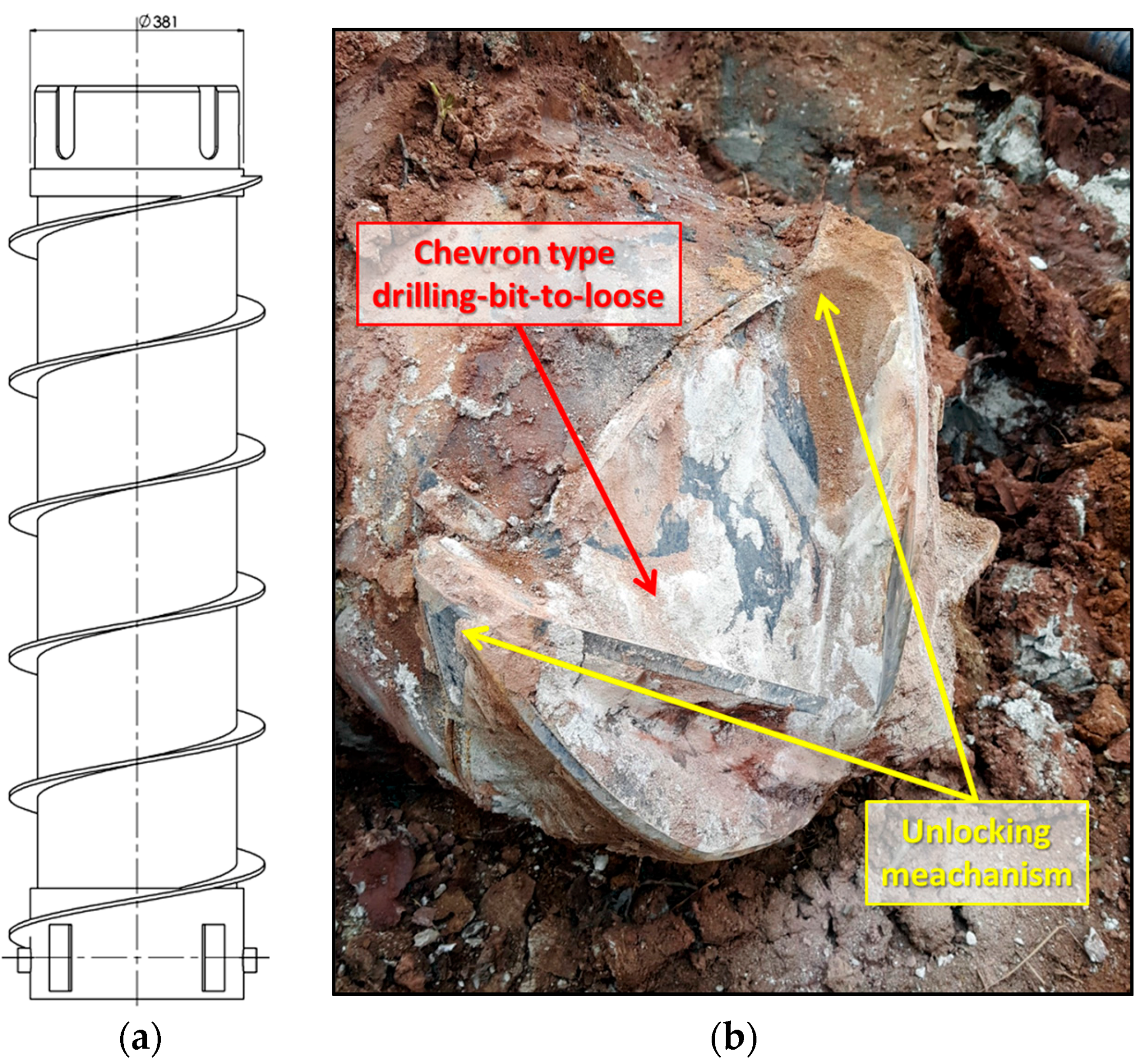
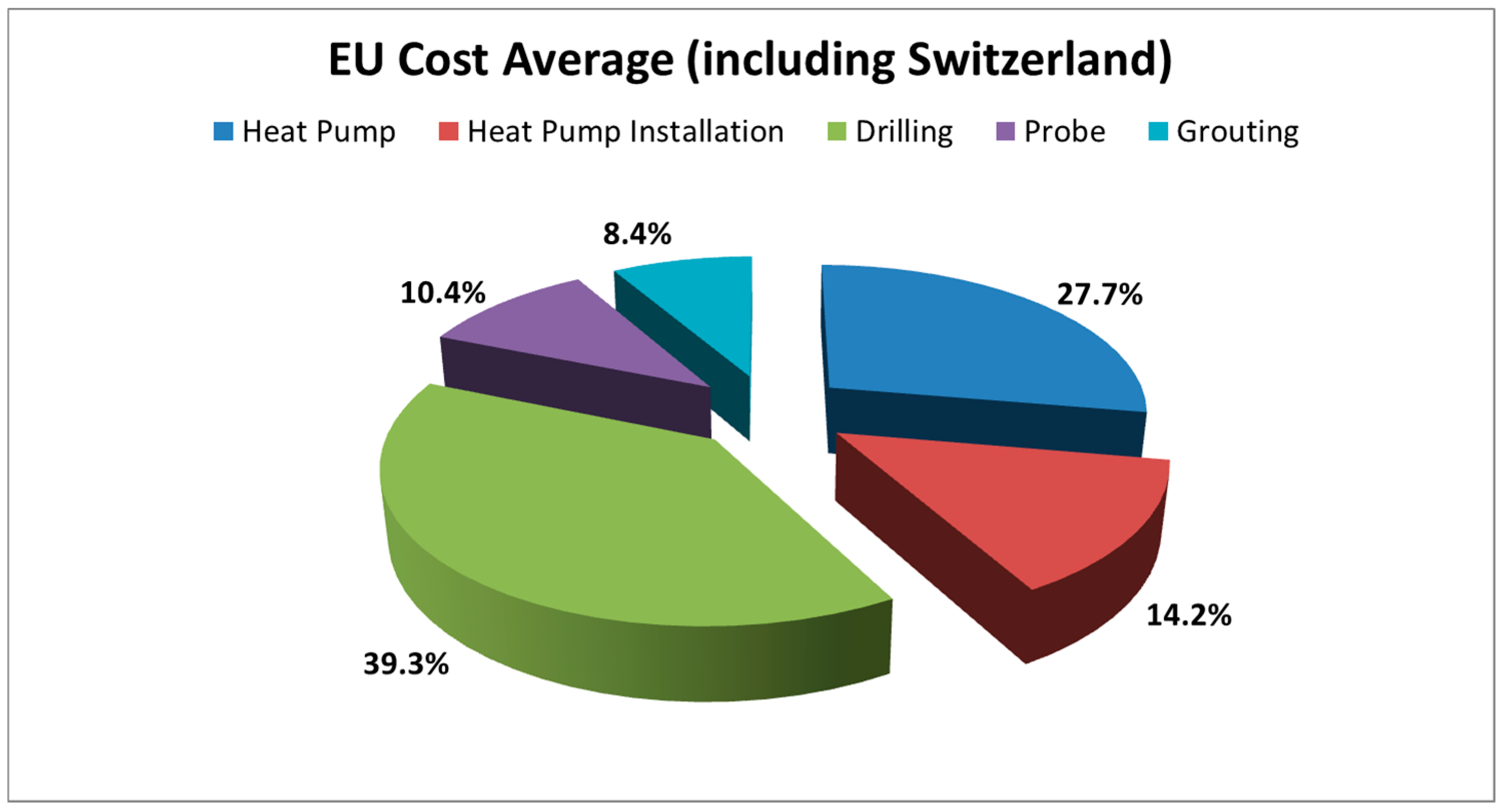
2.1. Standard Drilling Techniques and Developments
2.2. Data Acquisition
2.3. Data Modification
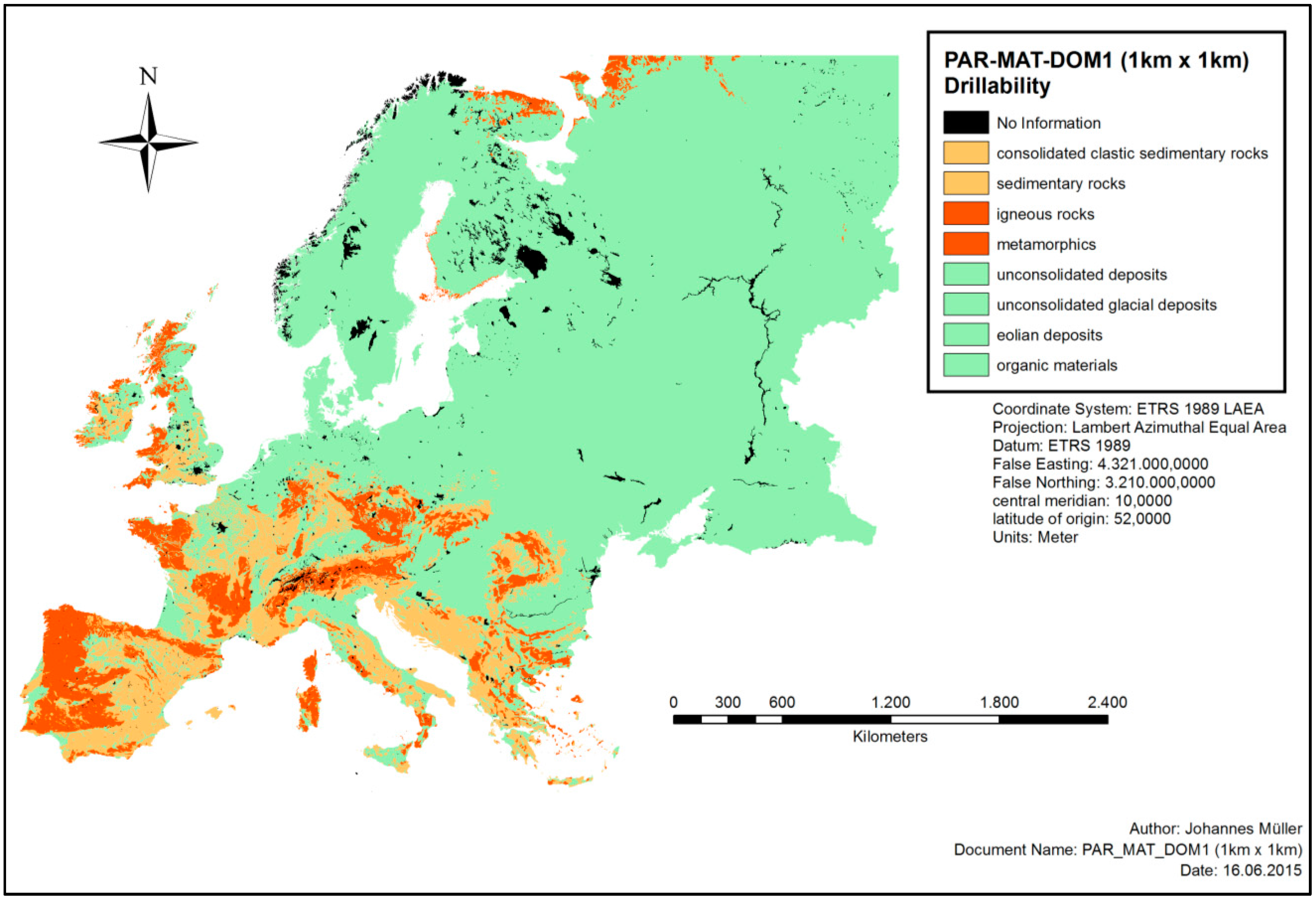
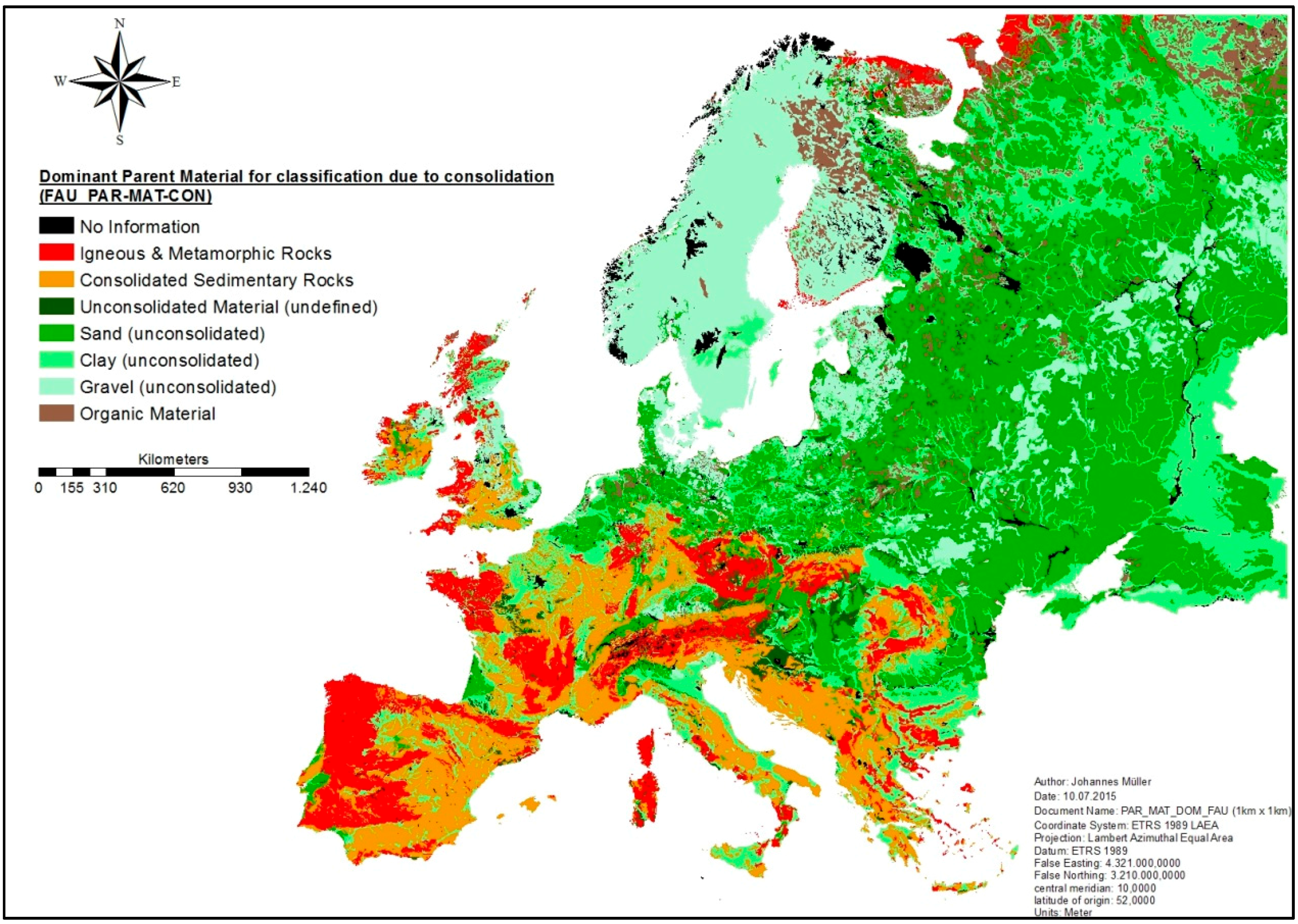
3. Results
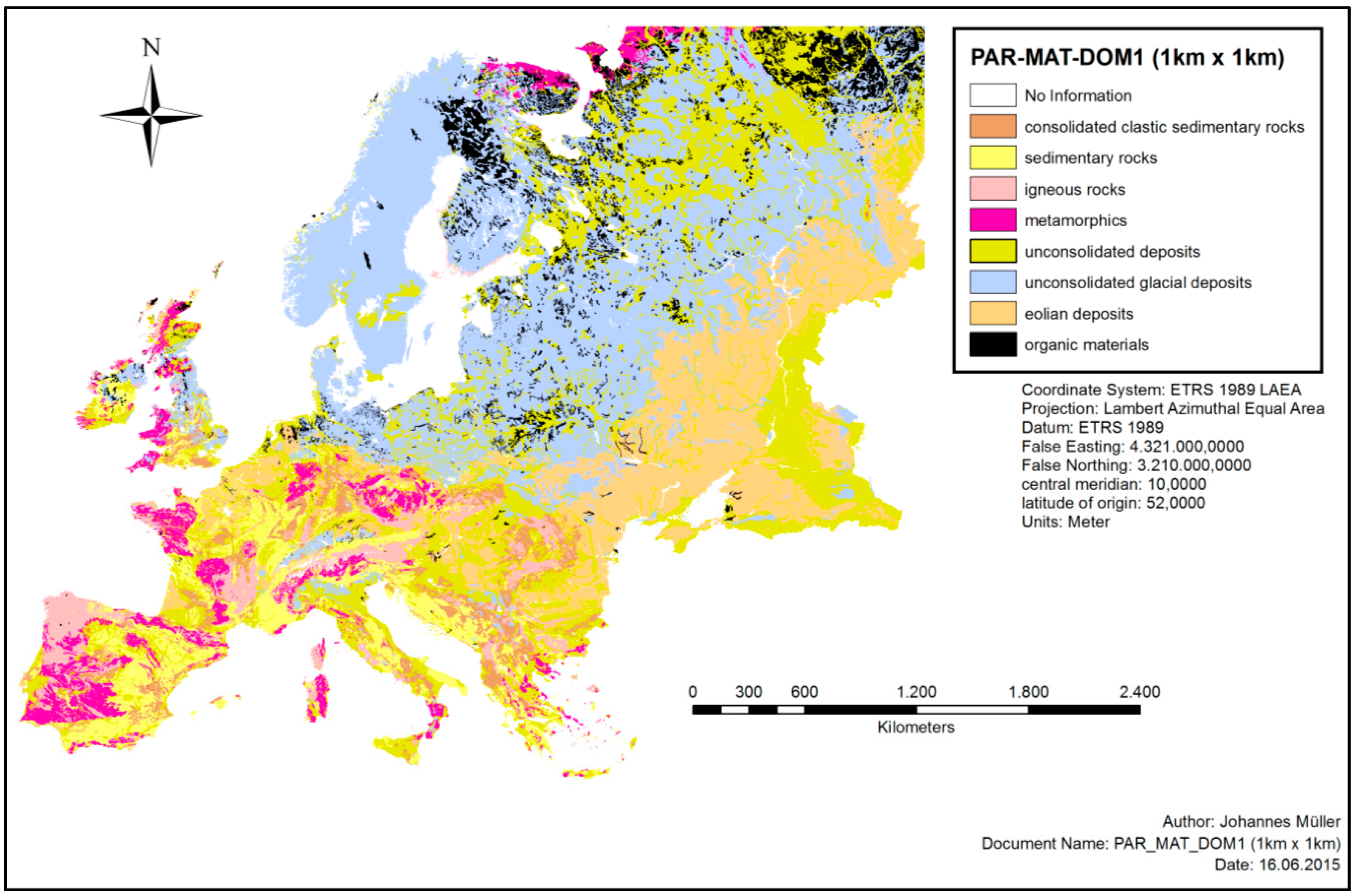
Hardness Map
4. Discussion
5. Conclusions
Acknowledgments
Author Contributions
Conflicts of Interest
Appendix A

| 0 | No information |
| 1000 | consolidated-clastic-sedimentary rocks |
| 1400 | facies bound rock |
| 1100 | psephite or rudite |
| 1410 | flysch |
| 1110 | conglomerate |
| 1411 | sandy flysch |
| 1111 | pudding stone |
| 1412 | clayey and silty flysch |
| 1120 | breccia |
| 1413 | conglomeratic flysch |
| 1200 | psammite or arenite |
| 1420 | molasse |
| 1210 | sandstone |
| 1211 | calcareous sandstone |
| 1212 | ferruginous sandstone |
| 1213 | clayey sandstone |
| 1214 | quartzitic sandstone/orthoquartzite |
| 1215 | micaceous sandstone |
| 1220 | arkose |
| 1230 | graywacke |
| 1231 | feldspathic graywacke |
| 1300 | pelite, lutite or argilite |
| 1310 | claystone/mudstone |
| 1311 | kaolinite |
| 1312 | bentonite |
| 1320 | siltstone |
| 2000 | edimentary rocks (chemically pre-cipitated, evaporated, or organogenic or biogenic in origin) |
| 2100 | calcareous rocks |
| 2110 | limestone |
| 2111 | hard limestone |
| 2112 | soft limestone |
| 2113 | marly limestone |
| 2114 | chalky limestone |
| 2115 | detrital limestone |
| 2116 | carbonaceous limestone |
| 2117 | lacustrine or freshwater limestone |
| 2118 | travertine/calcareous sinter |
| 2119 | cavernous limestone |
| 2120 | dolomite |
| 2121 | cavernous dolomite |
| 2122 | calcareous dolomite |
| 2130 | marlstone |
| 2140 | marl |
| 2141 | chalk marl |
| 2142 | gypsiferous marl |
| 2150 | chalk |
| 2200 | evaporites |
| 2210 | gypsum |
| 2220 | anhydrite |
| 2230 | halite |
| 2300 | siliceous rocks |
| 2310 | chert, hornstone, flint |
| 2320 | diatomite/radiolarite |
| 3000 | igneous rocks |
| 3100 | acid to intermediate plutonic rocks |
| 3110 | granite |
| 3120 | granodiorite |
| 3130 | diorite |
| 3131 | quartz diorite |
| 3132 | gabbro diorite |
| 3140 | syenite |
| 3200 | basic plutonic rocks |
| 3210 | gabbro |
| 3300 | ultrabasic plutonic rocks |
| 3310 | peridotite |
| 3320 | pyroxenite |
| 3400 | acid to intermediate volcanic rocks |
| 3410 | rhyolite |
| 3411 | obsidian |
| 3412 | quartz porphyrite |
| 3420 | dacite |
| 3430 | andesite |
| 3431 | porphyrite (intermediary) |
| 3440 | phonolite |
| 3441 | tephritic phonolite |
| 3450 | trachyte |
| 3500 | basic to ultrabasic volcanic rocks |
| 3510 | basalt |
| 3520 | diabase |
| 3530 | pikrite |
| 3600 | dike rocks |
| 3610 | aplite |
| 3620 | pegmatite |
| 3630 | lamprophyre |
| 3700 | pyroclastic rocks (tephra) |
| 3710 | tuff/tuffstone |
| 3711 | agglomeratic tuff |
| 3712 | block tuff |
| 3713 | lapilli tuff |
| 3720 | tuffite |
| 3721 | sandy tuffite |
| 3722 | silty tuffite |
| 3723 | clayey tuffite |
| 3730 | volcanic scoria/volcanic breccia |
| 3740 | volcanic ash |
| 3750 | ignimbrite |
| 3760 | pumice |
| 4000 | metamorphic rocks |
| 4100 | weakly metamorphic rocks |
| 4110 | (meta-) shale/argillite |
| 4120 | slate |
| 4121 | graphitic slate |
| 4200 | acid regional metamorphic rocks |
| 4210 | (meta-) quartzite |
| 4211 | quartzite schist |
| 4220 | phyllite |
| 4230 | micaschist |
| 4240 | gneiss |
| 4250 | granulite (sensu stricto) |
| 4260 | migmatite |
| 4300 | basic regional metamorphic rocks |
| 4310 | greenschist |
| 4311 | prasinite |
| 4312 | chlorite |
| 4313 | talc schist |
| 4320 | amphibolite |
| 4330 | eclogite |
| 4400 | ultrabasic regional metamorphic rocks |
| 4410 | serpentinite |
| 4411 | greenstone |
| 4500 | calcareous regional metamorphic rocks |
| 4510 | marble |
| 4520 | calcschist, skam |
| 4600 | rocks formed by contact metamor-phism |
| 4610 | contact slate |
| 4611 | nodular slate |
| 4620 | hornfels |
| 4630 | calsilicate rocks |
| 4700 | tectogenetic metamorphism rocks or cataclasmic metamorphism |
| 4710 | tectonic breccia |
| 4720 | cataclasite |
| 4730 | mylonite |
| 5000 | unconsolidated deposits (alluvium, weathering residuum and slope deposits) |
| 5100 | marine and estuarine sands |
| 5110 | pre-quaternary sand |
| 5111 | tertiary sand |
| 5120 | quaternary sand |
| 5121 | holocene coastal sand with shells |
| 5122 | delta sand |
| 5200 | marine and estuarine clays and silts |
| 5210 | pre-quaternary clay and silt |
| 5211 | tertiary clay |
| 5212 | tertiary silt |
| 5220 | quaternary clay and silt |
| 5221 | holocene clay |
| 5222 | holocene silt |
| 5300 | fluvial sands and gravels |
| 5310 | river terrace sand or gravel |
| 5311 | river terrace sand |
| 5312 | river terrace gravel |
| 5320 | floodplain sand or gravel |
| 5321 | floodplain sand |
| 5322 | floodplain gravel |
| 5400 | fluvial clays, silts and loams |
| 5410 | river clay and silt |
| 5411 | terrace clay and silt |
| 5412 | floodplain clay and silt |
| 5420 | river loam |
| 5421 | terrace loam |
| 5430 | overbank deposit |
| 5431 | floodplain clay and silt |
| 5432 | floodplain loam |
| 5500 | lake deposits |
| 5510 | lake sand and delta sand |
| 5520 | lake marl, bog lime |
| 5530 | lake silt |
| 5600 | residual and redeposited loams from silicate rocks |
| 5610 | residual loam |
| 5611 | stony loam |
| 5612 | clayey loam |
| 5620 | redeposited loam |
| 5621 | running-ground |
| 5700 | residual and redeposited clays from calcareous rocks |
| 5710 | residual clay |
| 5711 | clay with flints |
| 5712 | ferruginous residual clay |
| 5713 | calcareous clay |
| 5714 | non-calcareous clay |
| 5715 | marly clay |
| 5720 | redeposited clay |
| 5721 | stony clay |
| 5800 | slope deposits |
| 5810 | slope-wash alluvium |
| 5820 | colluvial deposit |
| 5830 | talus scree |
| 5831 | stratified slope deposits |
| 6000 | unconsolidated glacial deposits/glacial drift |
| 6100 | morainic deposits |
| 6110 | glacial till |
| 6111 | boulder clay |
| 6120 | glacial debris |
| 6200 | glaciofluvial deposits |
| 6210 | outwash sand, glacial sand |
| 6220 | outwash gravels glacial gravels |
| 6300 | glaciolacustrine deposits |
| 6310 | varves |
| 7000 | eolian deposits |
| 7100 | loess |
| 7110 | loamy loess |
| 7120 | sandy loess |
| 7200 | aeolian sands |
| 7210 | dune sand |
| 7220 | cover sand |
| 8000 | organic materials |
| 8100 | peat (mires) |
| 8110 | rainwater fed moor peat (raised bog) |
| 8111 | folic peat |
| 8112 | fibric peat |
| 8113 | terric peat |
| 8120 | groundwater fed bog peat |
| 8200 | slime and ooze deposits |
| 8210 | gyttja, sapropel |
| 8300 | carbonaceaous rocks (caustobiolite) |
| 8310 | lignite (brown coal) |
| 8320 | hard coal |
| 8330 | anthracite |
| 9000 | anthropogenic deposits |
| 9100 | redeposited natural materials |
| 9110 | sand and gravel fill |
| 9120 | loamy fill |
| 9200 | dump deposits |
| 9210 | rubble/rubbish |
| 9220 | industrial ashes and slag |
| 9230 | industrial sludge |
| 9240 | industrial waste |
| 9300 | anthropogenic organic materials |
References
- Bertermann, D.; Müller, J. Actual GSHE Installation with Reference Costs and Performances; FAU Erlangen-Nuremberg: Erlangen, Germany, 2015; p. 122. Available online: http://cheap-gshp.eu/wp-content/uploads/2016/07/Cheap-GSHPs_T2.1_FAU_D2.1-vs2.pdf (accessed on 27 November 2017).
- Zarrella, A.; Emmi, G.; Graci, S.; De Carli, M.; Cultrera, M.; Dalla Santa, G.; Galgaro, A.; Bertermann, D.; Müller, J.; Pockelé, L.; et al. Thermal Response Testing Results of Different Types of Borehole Heat Exchangers: An Analysis and Comparison of Interpretation Methods. Energies 2017, 10, 801. [Google Scholar] [CrossRef]
- Arnold, W. (Ed.) Flachbohrtechnik, 1st ed.; Deutscher Verlag für Grundstoffindustrie: Leipzig, Germany, 1993; pp. 144–162. ISBN 978-3-342-00640-4. [Google Scholar]
- State of Michigan. Water Well Drilling Methods. Available online: http://www.michigan.gov/documents/deq/deq-wb-dwehs-gwwfwim-section5_183030_7.pdf (accessed on 27 November 2017).
- Buja, H.-O. Handbuch der Baugrunderkennung: Geräte und Verfahren, 1st ed.; Vieweg + Teubner: Wiesbaden, Germany, 2009; pp. 147–153. ISBN 978-3-8348-0544-7. [Google Scholar]
- Bernini, M. Design and Costs of GSHEs and Drilling Machines for up to 500 mm; Project Deliverable ‘Cheap-GSHPs’ No. 2.3; HYDRA S.R.L.: Molinella, Italy, 2016; p. 42. Available online: http://cheap-gshp.eu/wp-content/uploads/2017/09/Cheap-GSHP-D2.3.pdf (accessed on 27 November 2017).
- OneGeology-Europe. Available online: http://www.eurogeosurveys.org/projects/onegeology-europe/ (accessed on 28 November 2017).
- Bertermann, D.; Klug, H.; Morper-Busch, L.; Bialas, C. Modelling vSGPs (very shallow geothermal potentials) in selected CSAs (case study areas). Energy 2014, 71, 226–244. [Google Scholar] [CrossRef]
- Bertermann, D.; Klug, H.; Morper-Busch, L. A pan-European planning basis for estimating the very shallow geothermal energy potentials. Renew. Energy 2015, 75, 335–347. [Google Scholar] [CrossRef]
- Panagos, P. The European Soil Database. In Proceedings of the Biodiversity Workshop; 2006. Available online: http://eusoils.jrc.ec.europa.eu (accessed on 20 November 2017).
- Panagos, P.; Van Liedekerke, M.; Jones, A.; Montanarella, L. European Soil Data Centre: Response to European policy support and public data requirements. Land Use Policy 2012, 29, 329–338. [Google Scholar] [CrossRef]
- Van Liedekerke, M.; Jones, A.; Panagos, P. ESDBv2 Raster Library—A Set of Rasters Derived from the European Soil Database Distribution v2. 0; European Commission and the European Soil Bureau Network, CDROM, EUR: Ispra, Italy, 2006. [Google Scholar]
- VDI-Gesellschaft Energietechnik (Ed.) 4640 Thermal Use of the Ground. Fundamentals, Approvals, Environmental Aspects, Part 1; Beuth Verlag GmbH: Berlin, Germany, 2000. [Google Scholar]
- Robertson, E.C. Thermal Properties of Rocks (No. 88-441). Available online: https://pubs.usgs.gov/of/1988/0441/report.pdf (accessed on 13 November 2017).
- Dalla Santa, G.; Peron, F.; Galgaro, A.; Cultrera, M.; Bertermann, D.; Mueller, J.; Bernardi, A. Laboratory Measurements of Gravel Thermal Conductivity: An Update Methodological Approach. Energy Procedia 2017, 125, 671–677. [Google Scholar] [CrossRef]
- Sass, I.; Burbaum, U. Damage to the historic town of Staufen (Germany) caused by geothermal drillings through anhydrite-bearing formations. Acta Carsologica 2010, 39. [Google Scholar] [CrossRef]


| Code | Value |
|---|---|
| 0 | No information |
| 1 | Consolidated clastic sedimentary rocks |
| 2 | Sedimentary rocks (chemically precipitated, evaporated, or organogenic or biogenic in origin) |
| 3 | Igneous rocks |
| 4 | Metamorphic rocks |
| 5 | Unconsolidated deposits (alluvium, weathering residuum, and slope deposits) |
| 6 | Unconsolidated glacial deposits/glacial drift |
| 7 | Eolian deposits |
| 8 | Organic materials |
| 9 | Anthropogenic deposits |
| PARMADO1 Code | Value | Level of Hardness |
|---|---|---|
| 0 | No information | No information |
| 1 | Consolidated clastic sedimentary rocks | Moderately consolidated |
| 2 | Sedimentary rocks (chemically precipitated, evaporated, or organogenic or biogenic in origin) | Moderately consolidated |
| 3 | Igneous rocks | Intensively consolidated |
| 4 | Metamorphic rocks | Intensively consolidated |
| 5 | Unconsolidated deposits (alluvium, weathering residuum and slope deposits) | Slightly consolidated |
| 6 | Unconsolidated glacial deposits/glacial drift | Slightly consolidated |
| 7 | Eolian deposits | Slightly consolidated |
| 8 | Organic materials | Slightly consolidated |
| 9 | Anthropogenic deposits | No information |
| Attribute Group PAR-MAT-DOM (Group Code for Dominant Parent Material) | Attribute Group PAR-MAT-DOM1 (Major Group Code for Dominant Parent Material) | ||
|---|---|---|---|
| Code PARMADO | Value PARMADO | Code PARMADO1 | Value PARMADO1 |
| 6000 | unconsolidated glacial deposits/glacial drift | 6 | unconsolidated glacial deposits/glacial drift |
| 6100 | morainic deposits | ||
| 6110 | glacial till | ||
| 6111 | boulder clay | ||
| 6120 | glacial debris | ||
| 6200 | glaciofluvial deposits | ||
| 6210 | outwash sand, glacial sand | ||
| 6220 | outwash gravels glacial gravels | ||
| 6300 | glaciolacustrine deposits | ||
| 6310 | varves | ||
| Attribute Group FAU_PAR-MAT-CON | Attribute Group PAR-MAT-DOM | |
|---|---|---|
| Code PARMAFAU | Value PARMAFAU | Code PARMADO |
| 0 | No information | 0 8320 9000 9210 9220 9230 9240 9300 |
| 1 | consolidated sedimentary rocks | 1000 1100 1110 1111 1120 1200 1210 1211 1212 1213 1214 1215 1220 1230 1231 1300 1310 1311 1312 1320 1400 1410 1411 1412 1413, 1420 2100 2110 2111 2112 2113 2114 2115 2116 2117 2118 2119 2120 2121 2122 2130 2140 2141 2142 2150 2200 2210 2220 2230 2300 2310 2320 |
| 2 | igneous & metamorphic rocks | 3000 3100 3100 3120 3130 3131 3132 3140 3200 3210 3300 3310 3320 3400 3410 3411 3412 3420 3430 3431 3440 3441 3450 3500 3510 3520 3530 3600 3610 3620 3630 3700 3710 3711 3712 3713 3720 3721 3722 3723 3730 3740 4000 4100 4110 4120 4121 4200 4210 4211 4220 4230 4240 4250 4260 4300 4310 4311 4312 4313 4320 4330 4400 4410 4411 4500 4510 4520 4600 4610 4611 4620 4630 4700 4710 4720 4730 |
| 3 | sand (unconsolidated) | 5100 5110 5111 5120 5121 5122 5311 5321 5430 5510 5830 5831 6120 6210 7120 7200 7210 7220 |
| 4 | clay (unconsolidated) | 5200 5210 5211 5212 5220 5221 5222 5400 5410 5411 5412 5420 5421 5431 5432 5500 5520 5530 5610 5611 5612 5620 5621 5710 5711 5712 5713 5714 5715 5720 5721 5820 6111 6300 6310 7110 9120 |
| 5 | gravel (unconsolidated) | 5312 5322 5810 6110 6220 9110 |
| 6 | organic material | 8000 8100 8110 8111 8112 8113 8120 8200 8210 8300 8310 8330 |
| 9 | unconsolidated material (undefined) | 5000 6000 |
© 2018 by the authors. Licensee MDPI, Basel, Switzerland. This article is an open access article distributed under the terms and conditions of the Creative Commons Attribution (CC BY) license (http://creativecommons.org/licenses/by/4.0/).
Share and Cite
Müller, J.; Galgaro, A.; Dalla Santa, G.; Cultrera, M.; Karytsas, C.; Mendrinos, D.; Pera, S.; Perego, R.; O’Neill, N.; Pasquali, R.; et al. Generalized Pan-European Geological Database for Shallow Geothermal Installations. Geosciences 2018, 8, 32. https://doi.org/10.3390/geosciences8010032
Müller J, Galgaro A, Dalla Santa G, Cultrera M, Karytsas C, Mendrinos D, Pera S, Perego R, O’Neill N, Pasquali R, et al. Generalized Pan-European Geological Database for Shallow Geothermal Installations. Geosciences. 2018; 8(1):32. https://doi.org/10.3390/geosciences8010032
Chicago/Turabian StyleMüller, Johannes, Antonio Galgaro, Giorgia Dalla Santa, Matteo Cultrera, Constantine Karytsas, Dimitrios Mendrinos, Sebastian Pera, Rodolfo Perego, Nick O’Neill, Riccardo Pasquali, and et al. 2018. "Generalized Pan-European Geological Database for Shallow Geothermal Installations" Geosciences 8, no. 1: 32. https://doi.org/10.3390/geosciences8010032