Mesozoic–Cenozoic Evolution of the Western Margin of South America: Case Study of the Peruvian Andes


Abstract
:
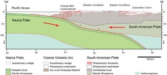
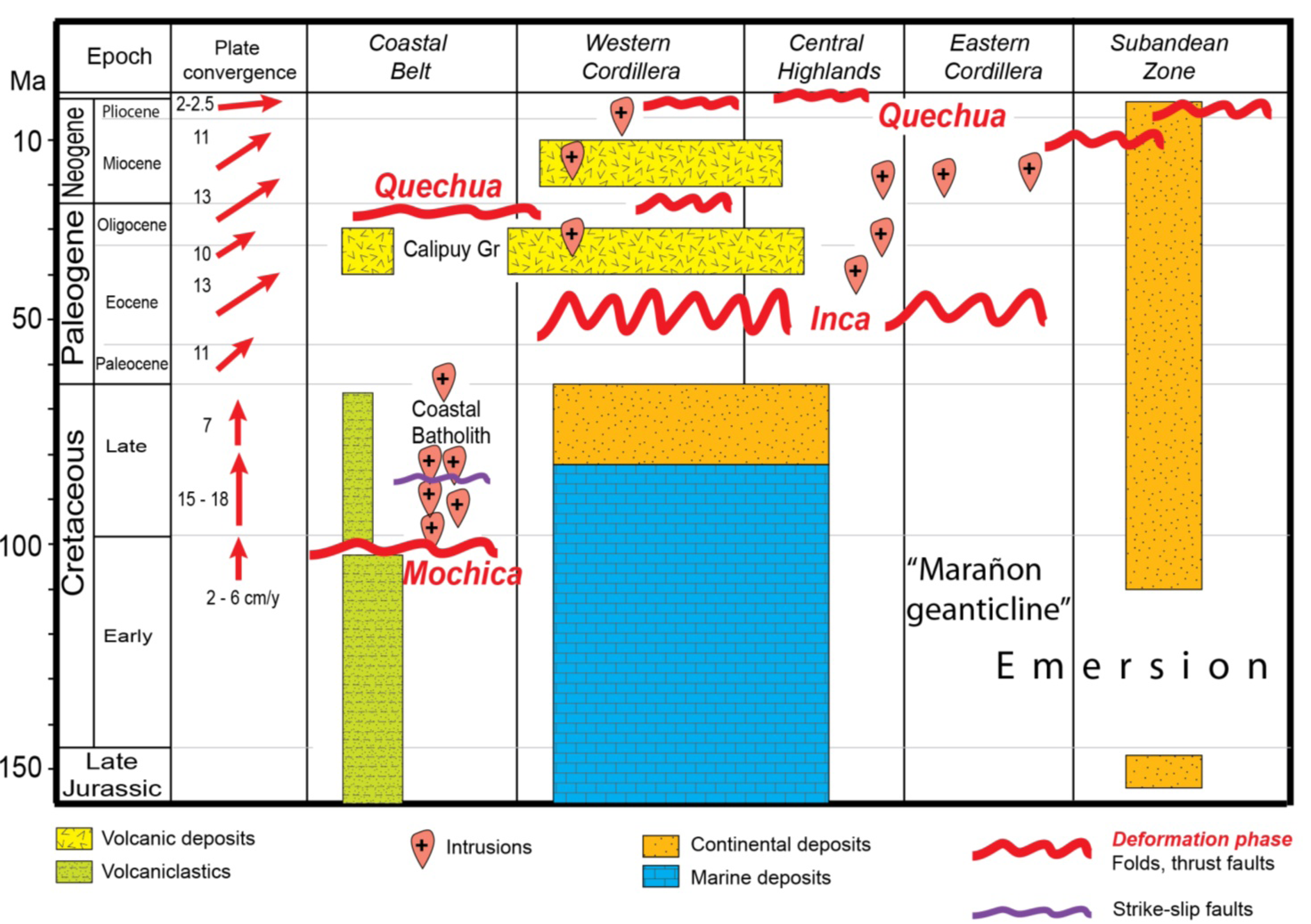
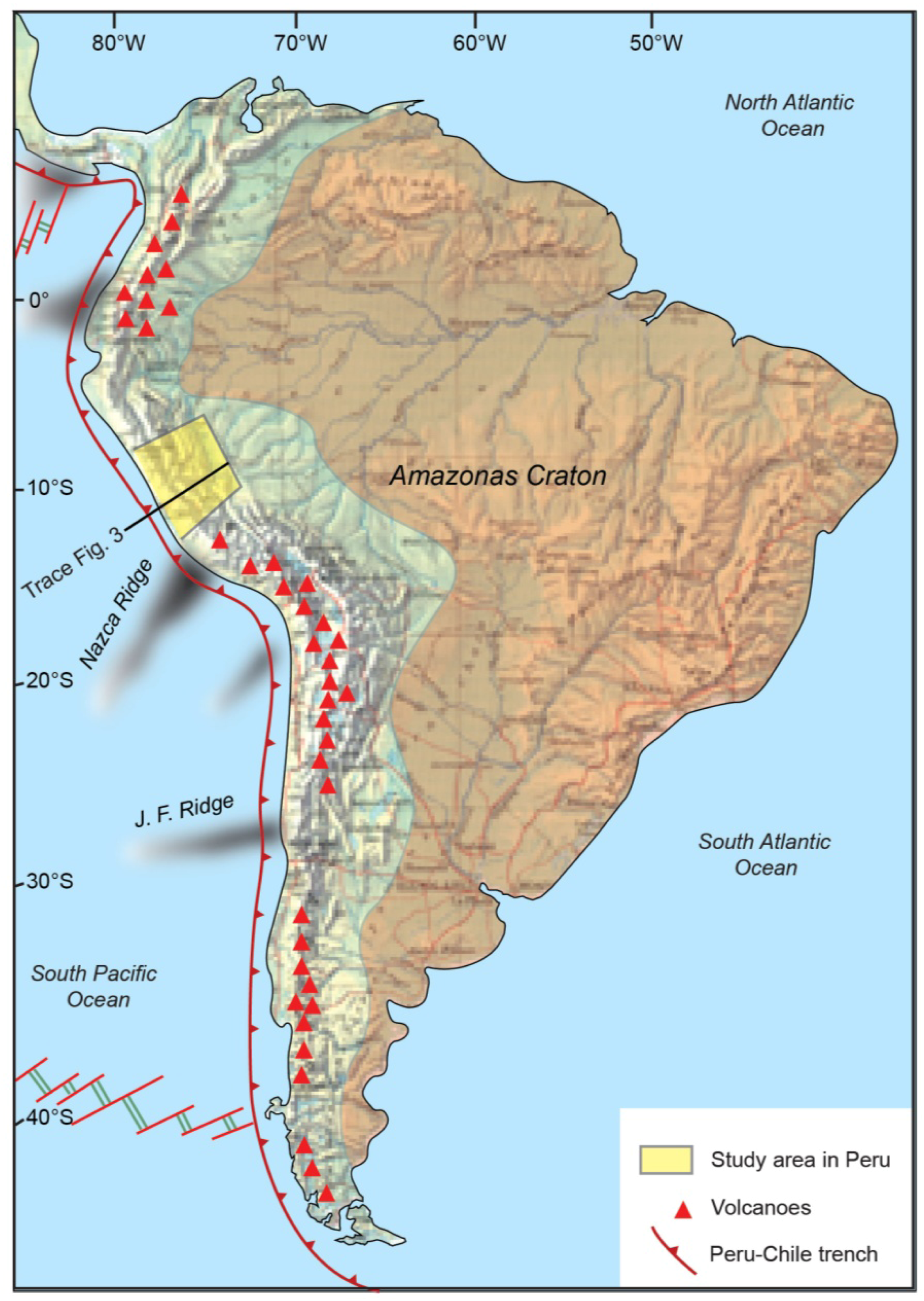
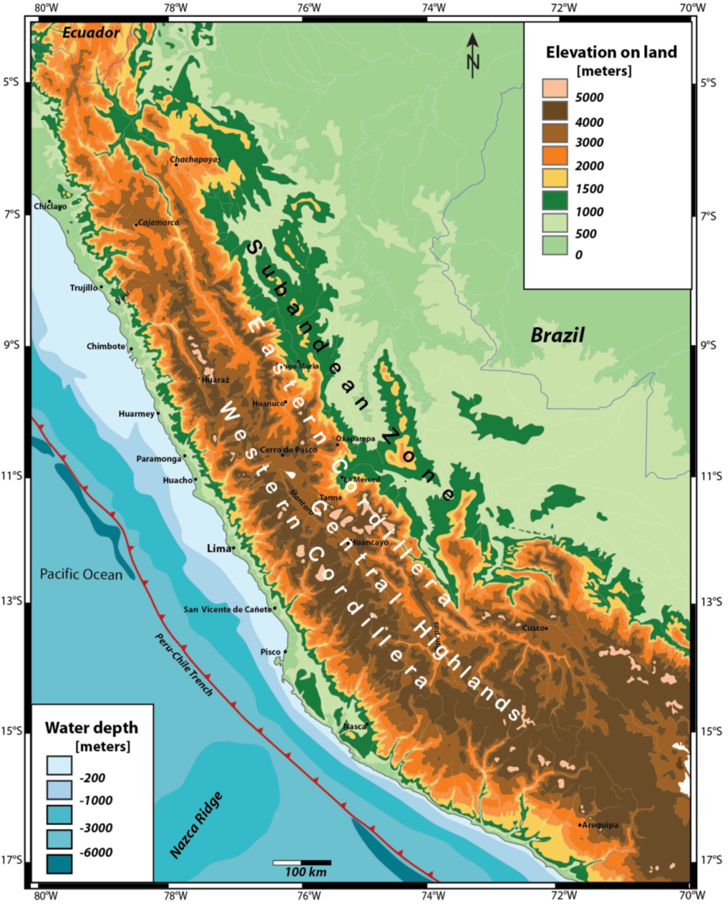
1. Introduction
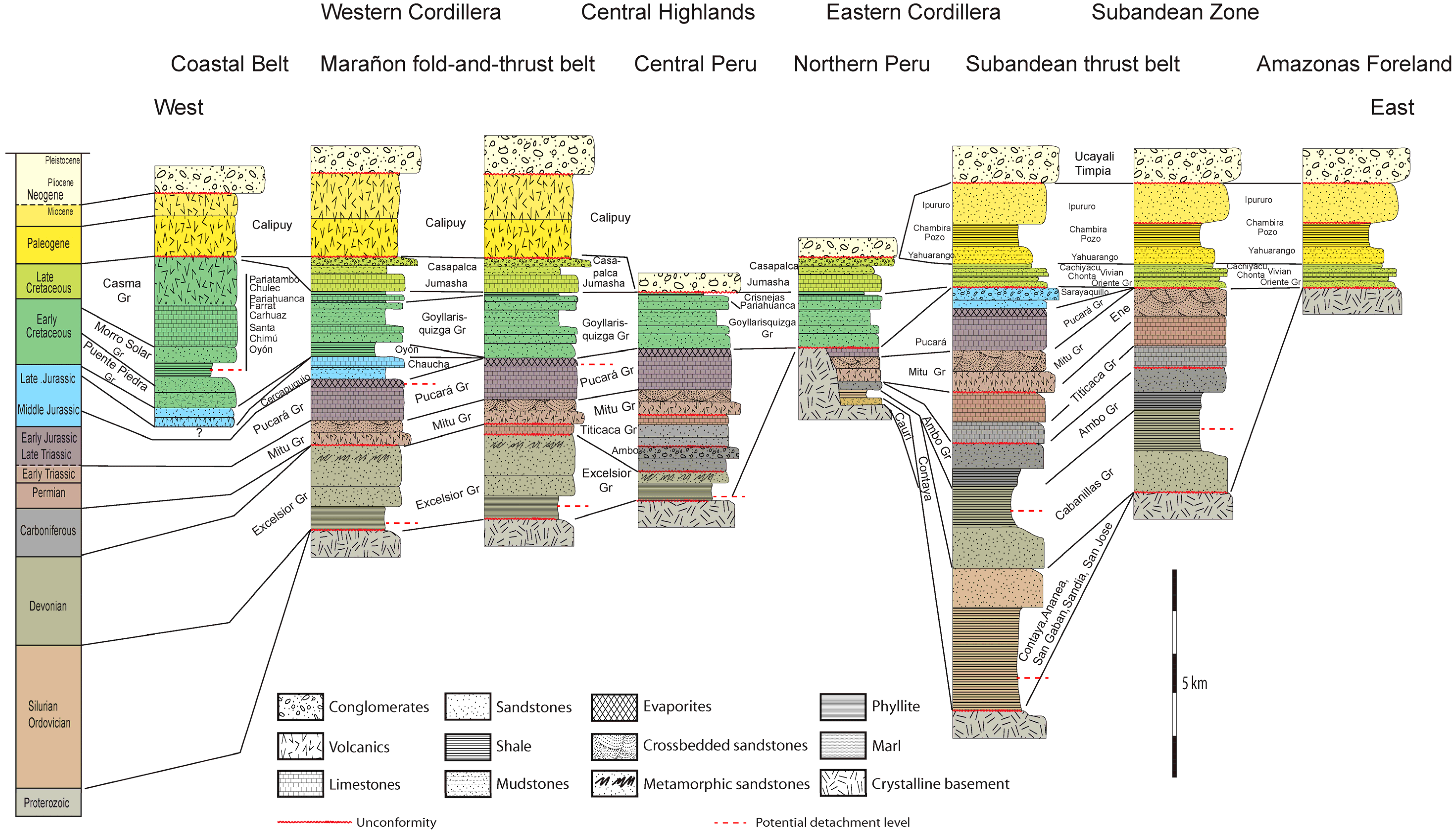
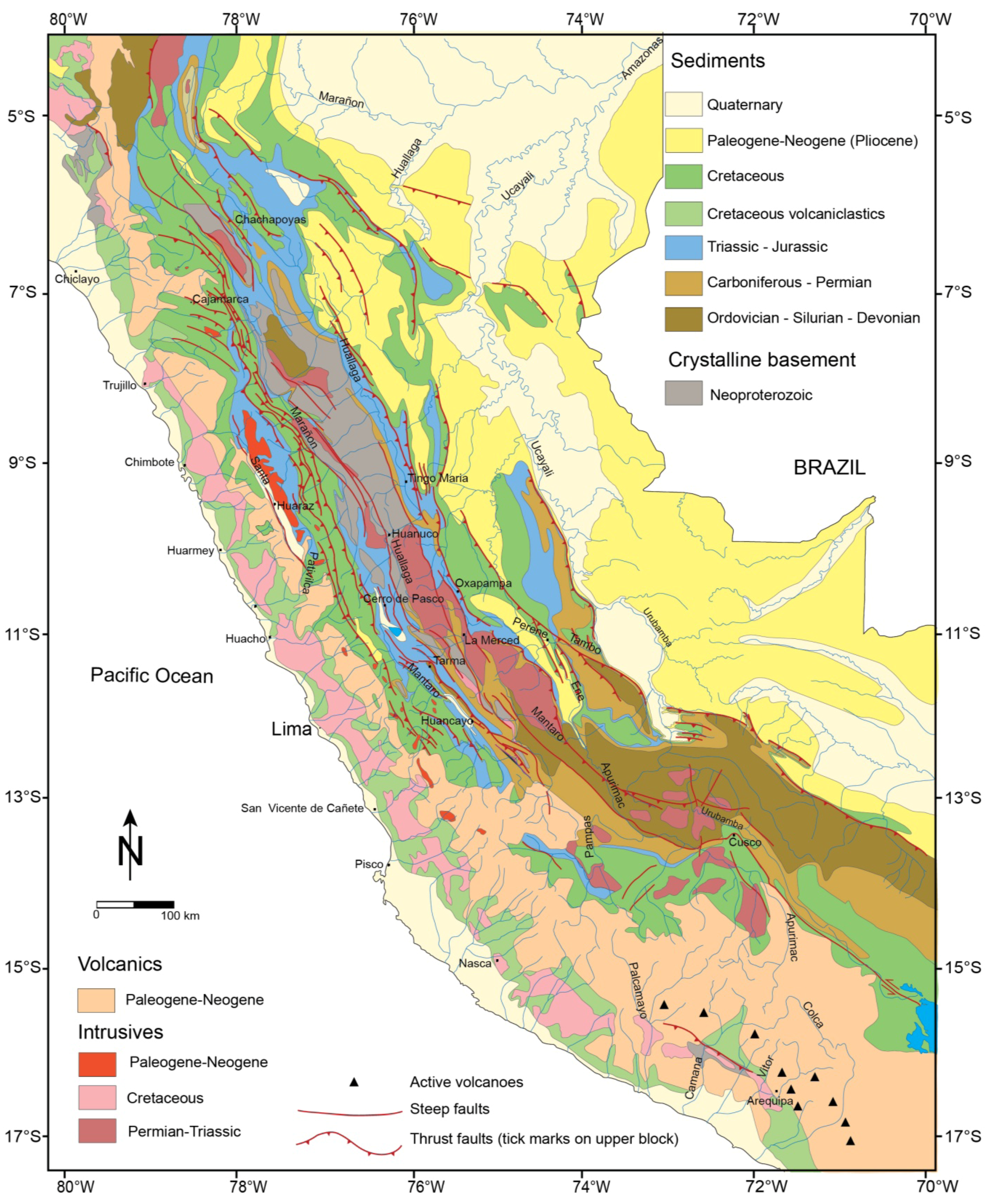
2. Stratigraphy

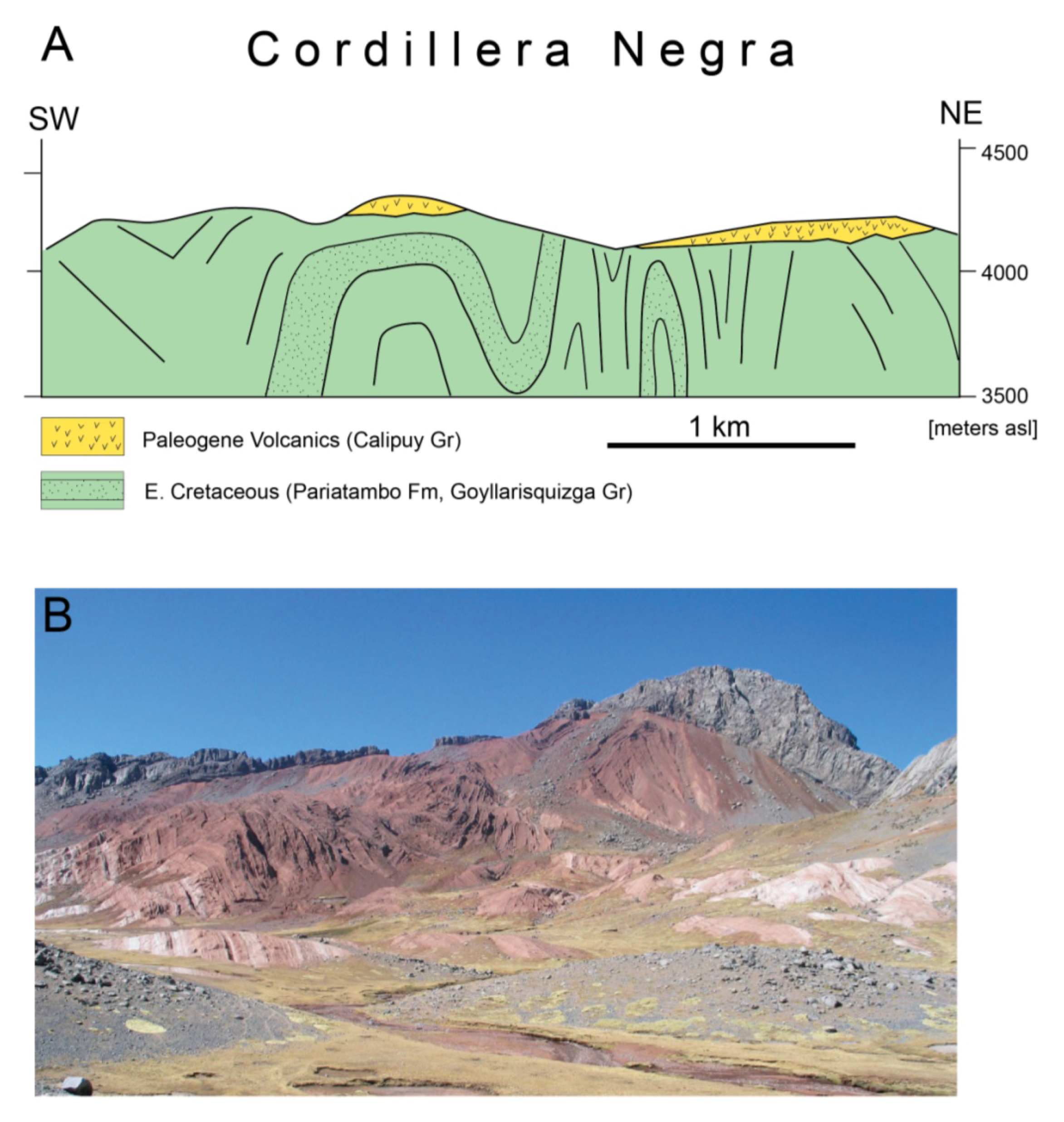
2.1. Western Cordillera
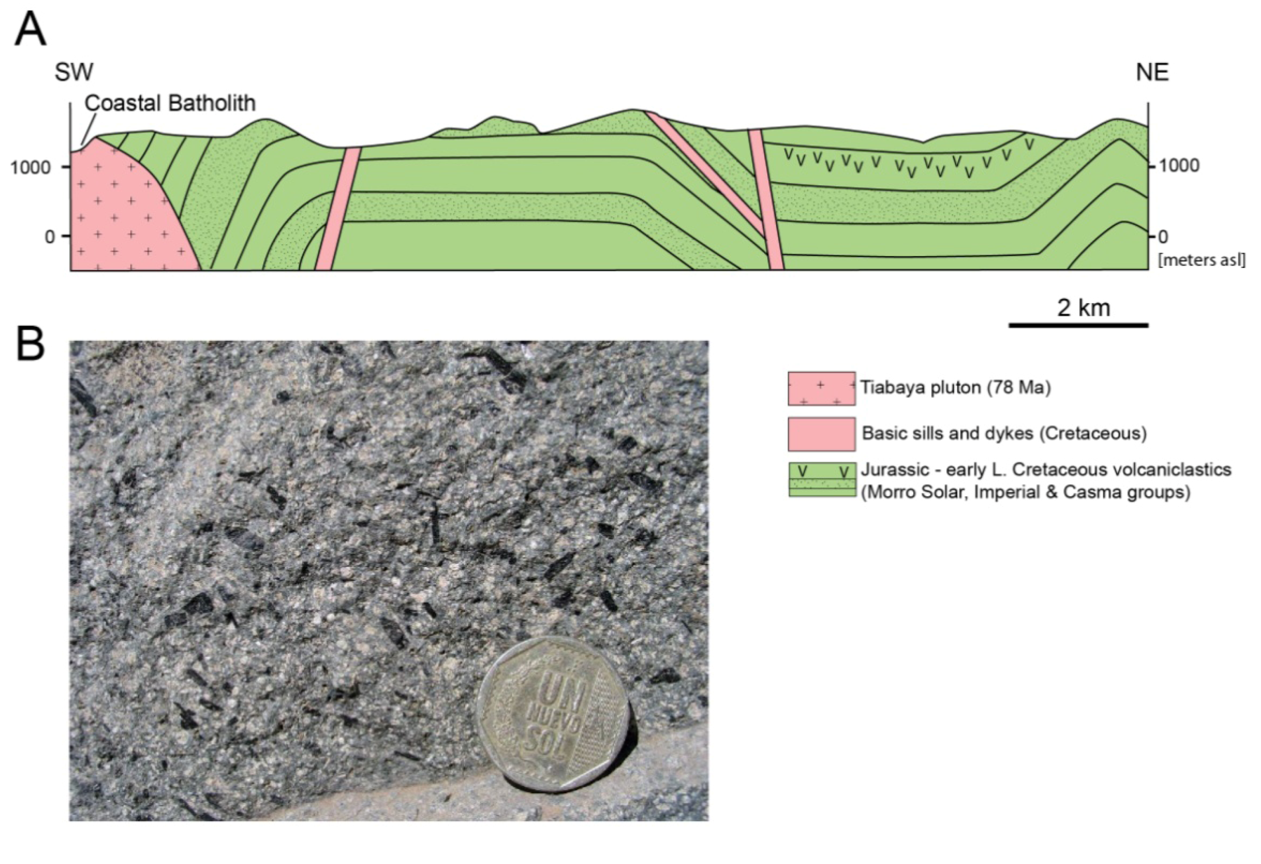
2.1.1. Coastal Belt
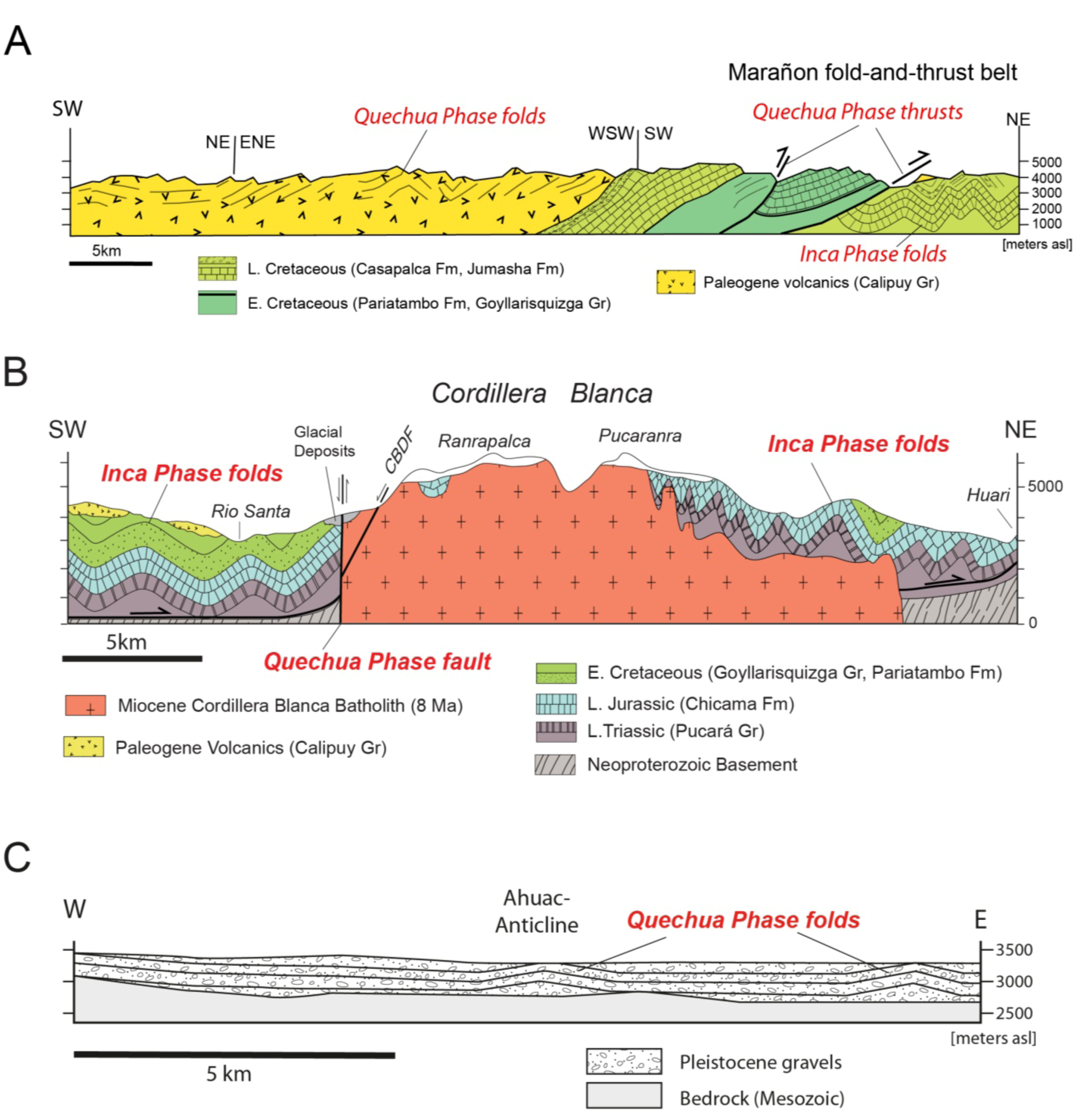
2.1.2. Marañon Fold-and-Thrust Belt
2.2. Central Highlands
2.3. Eastern Cordillera
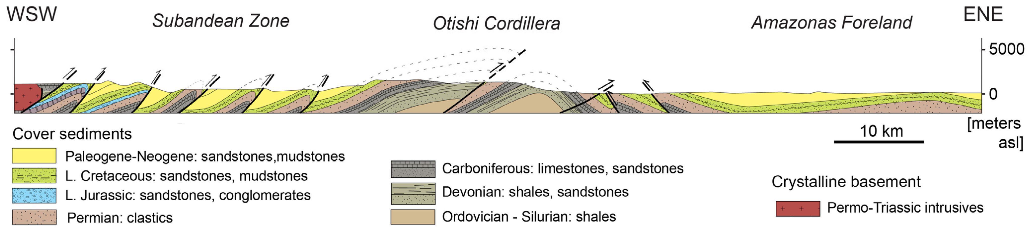
2.4. Subandean Zone
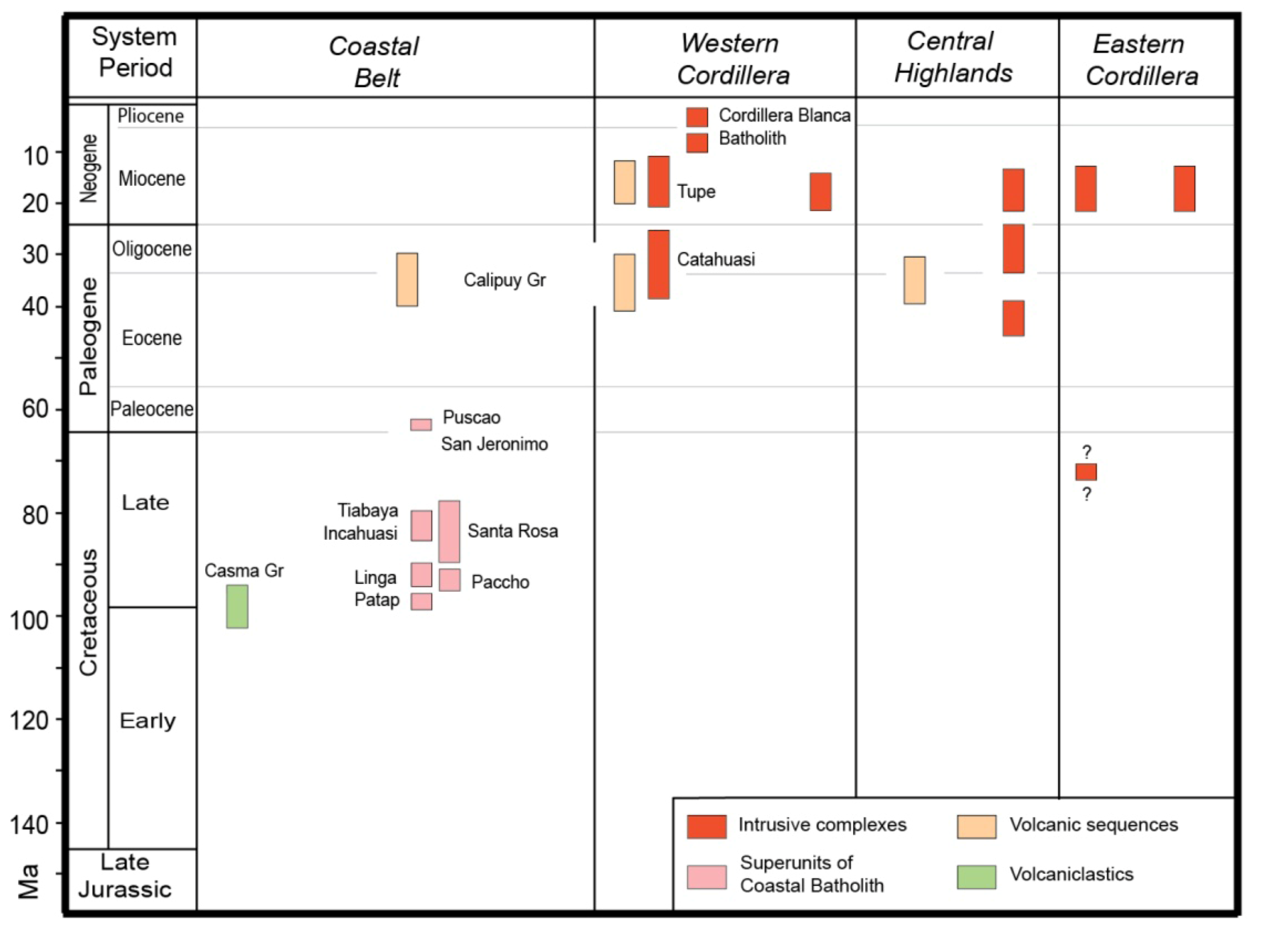
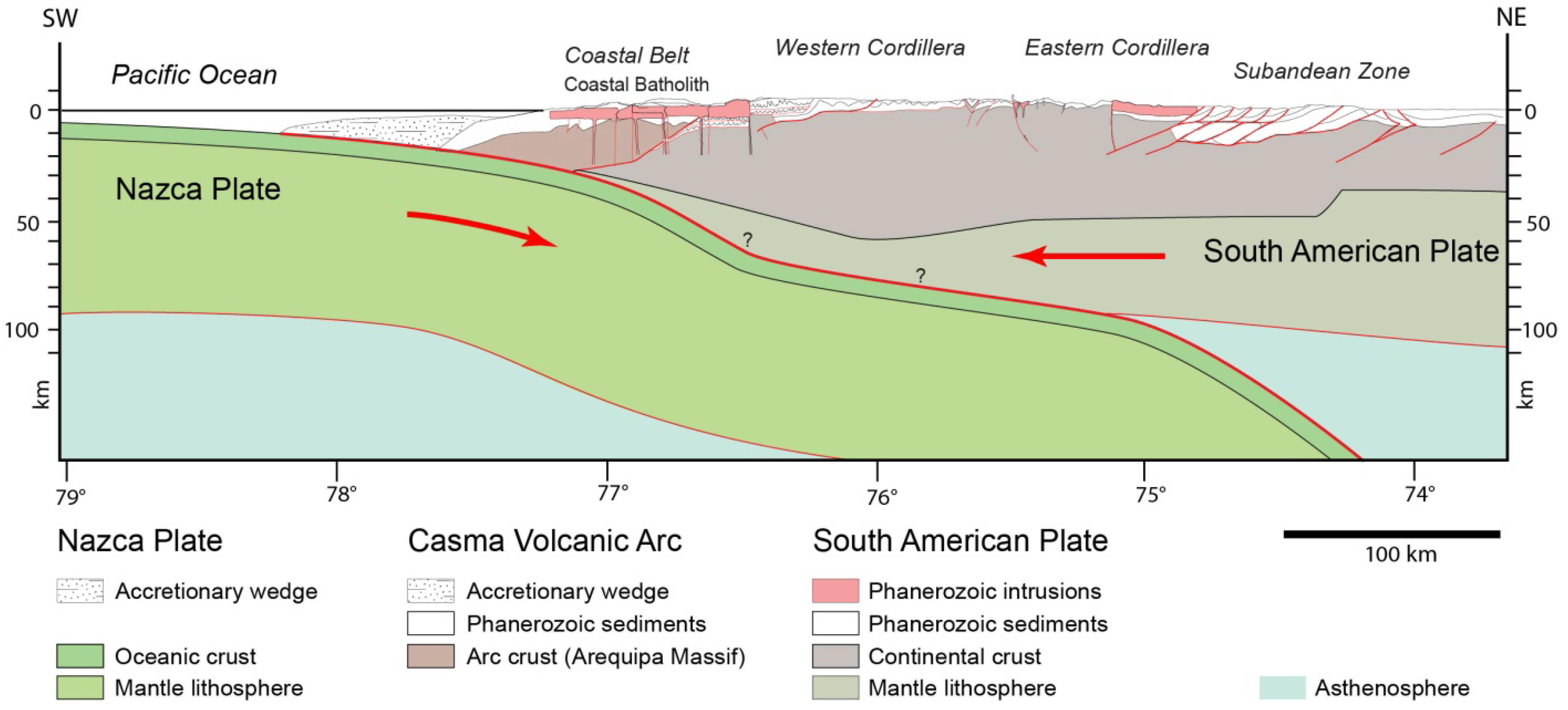
3. Magmatism

4. Geological Structure

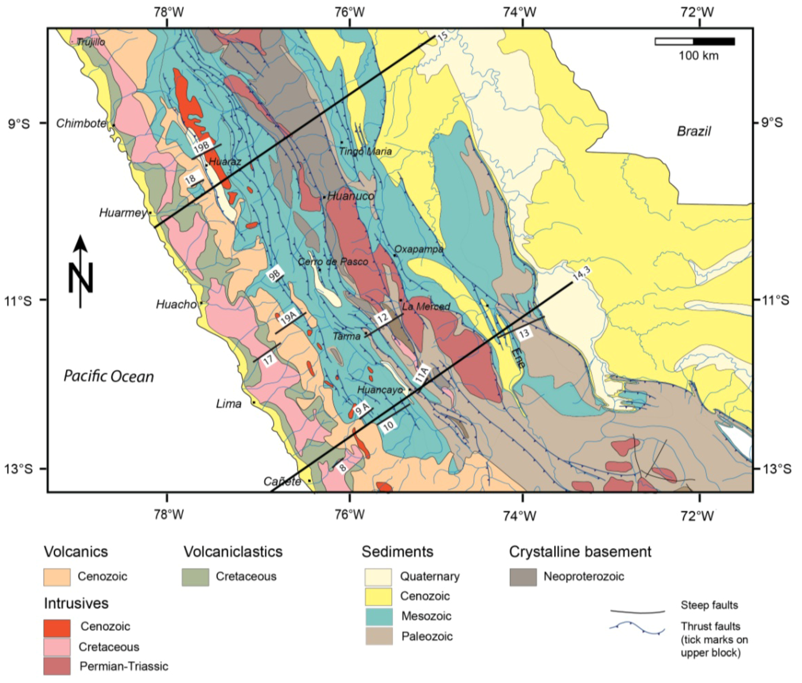
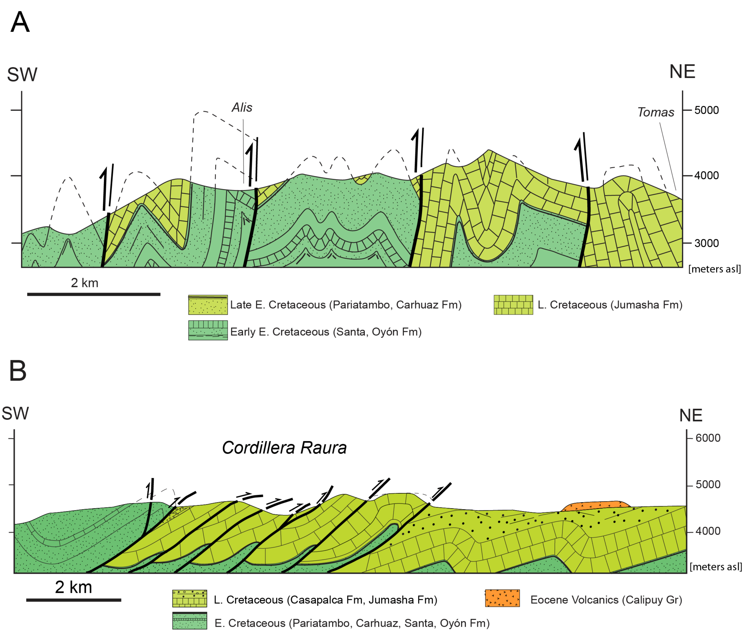
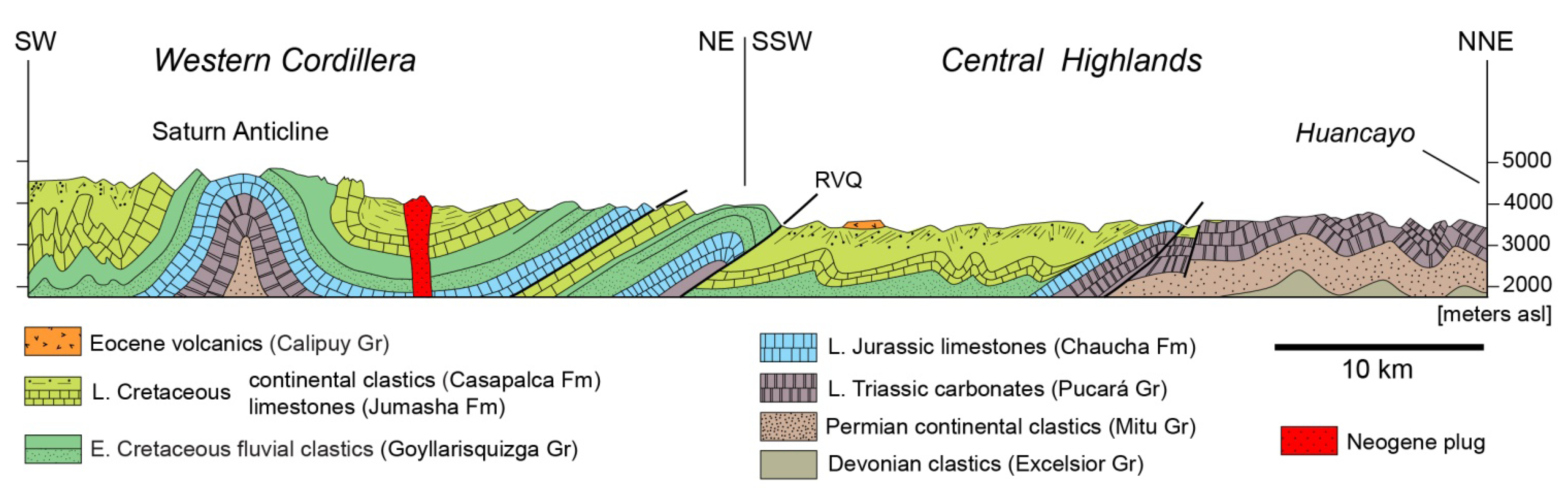
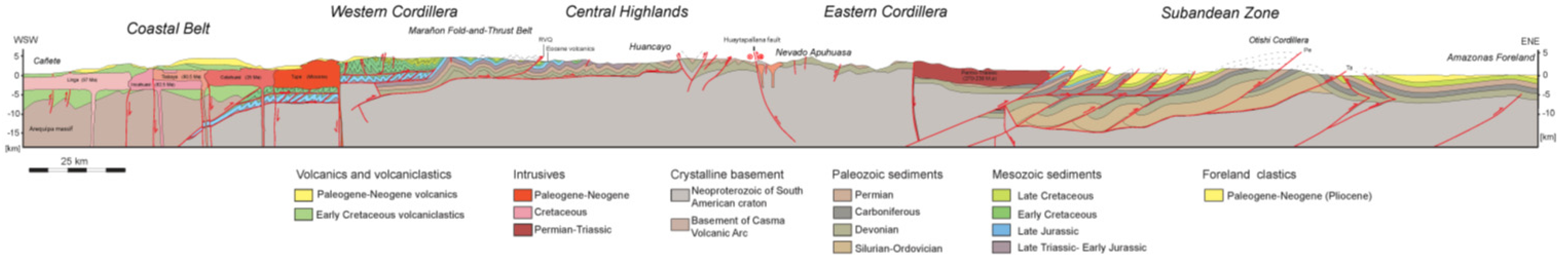
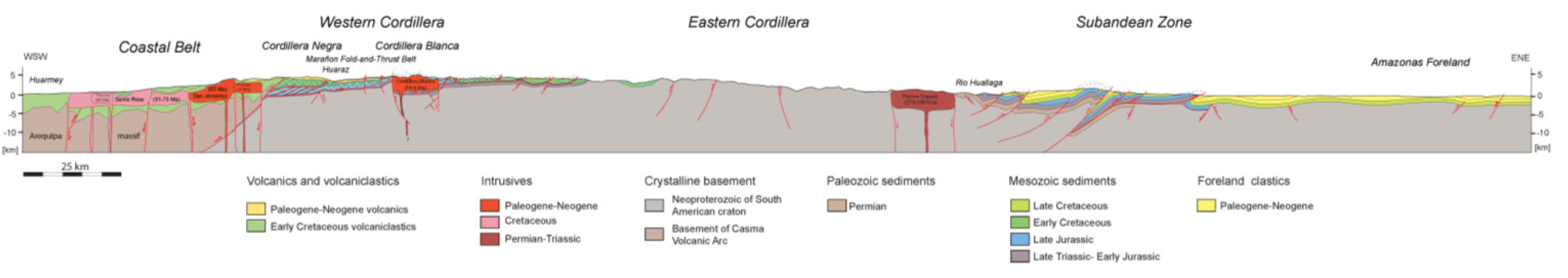
4.1. Structural Style in Cross-Sectional View
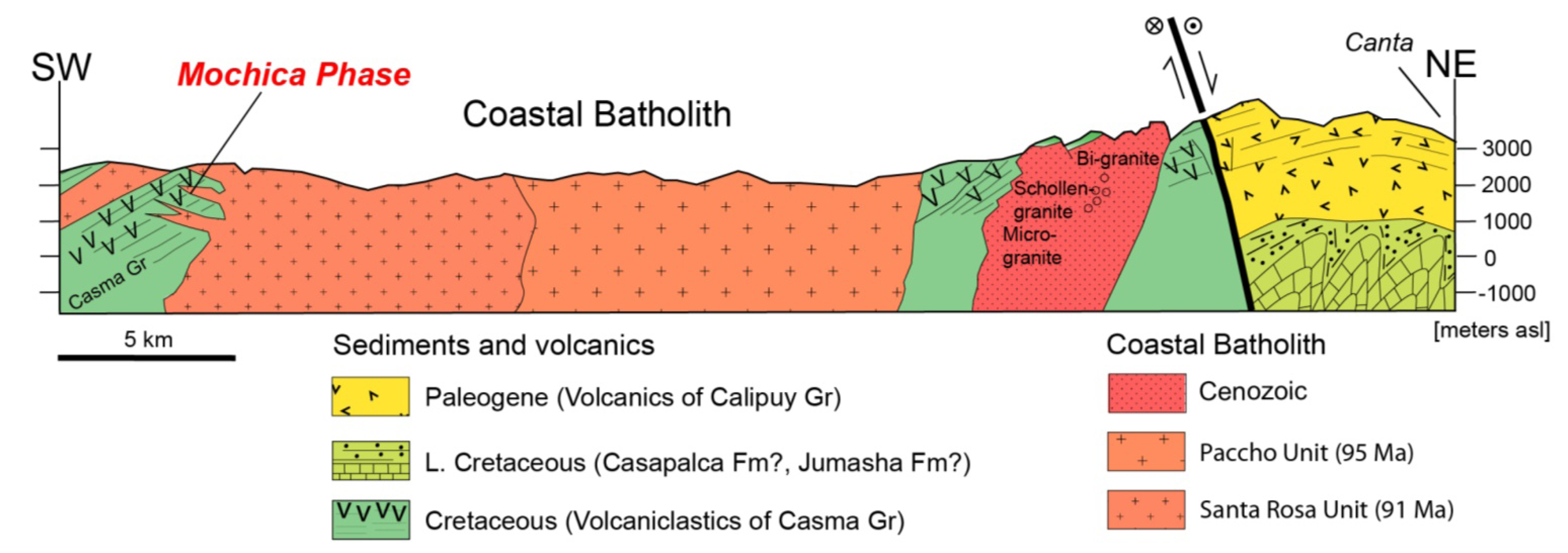
4.1.1. Coastal Belt

4.1.2. Western Cordillera

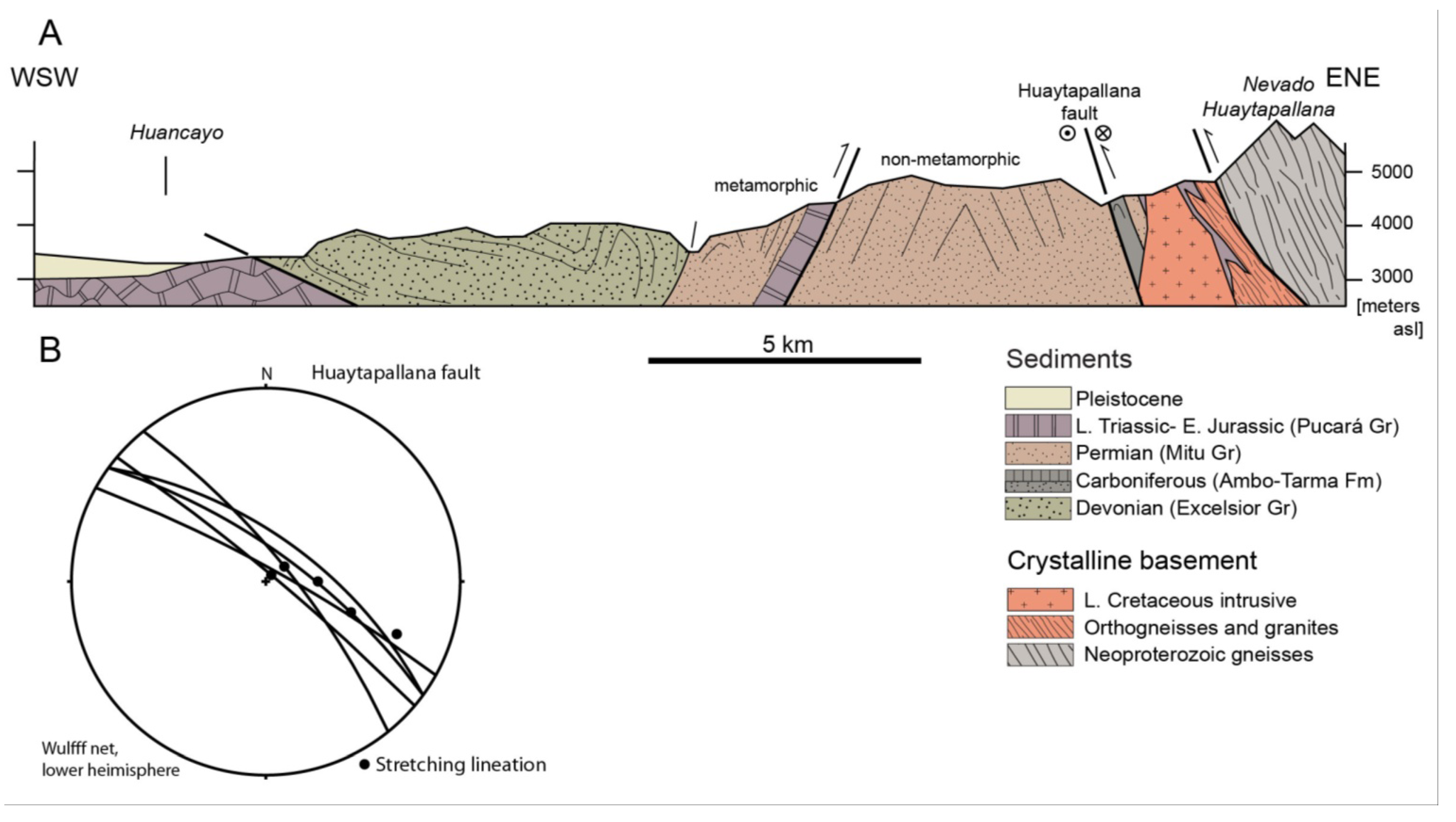
4.1.3. Central Highlands

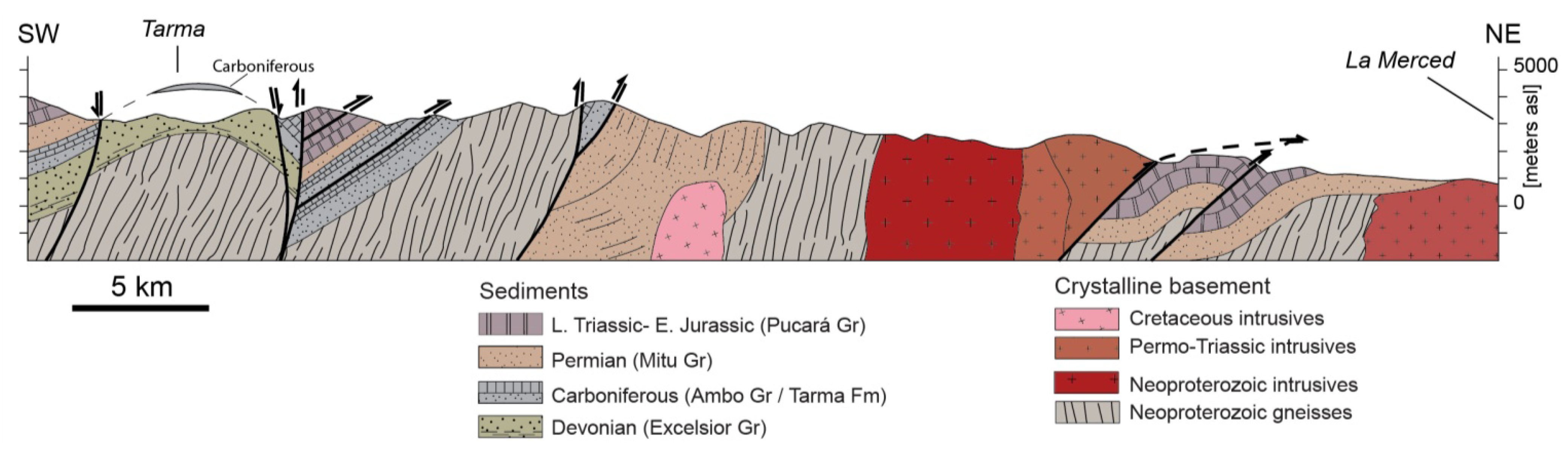
4.1.4. Eastern Cordillera

4.1.5. Subandean Zone
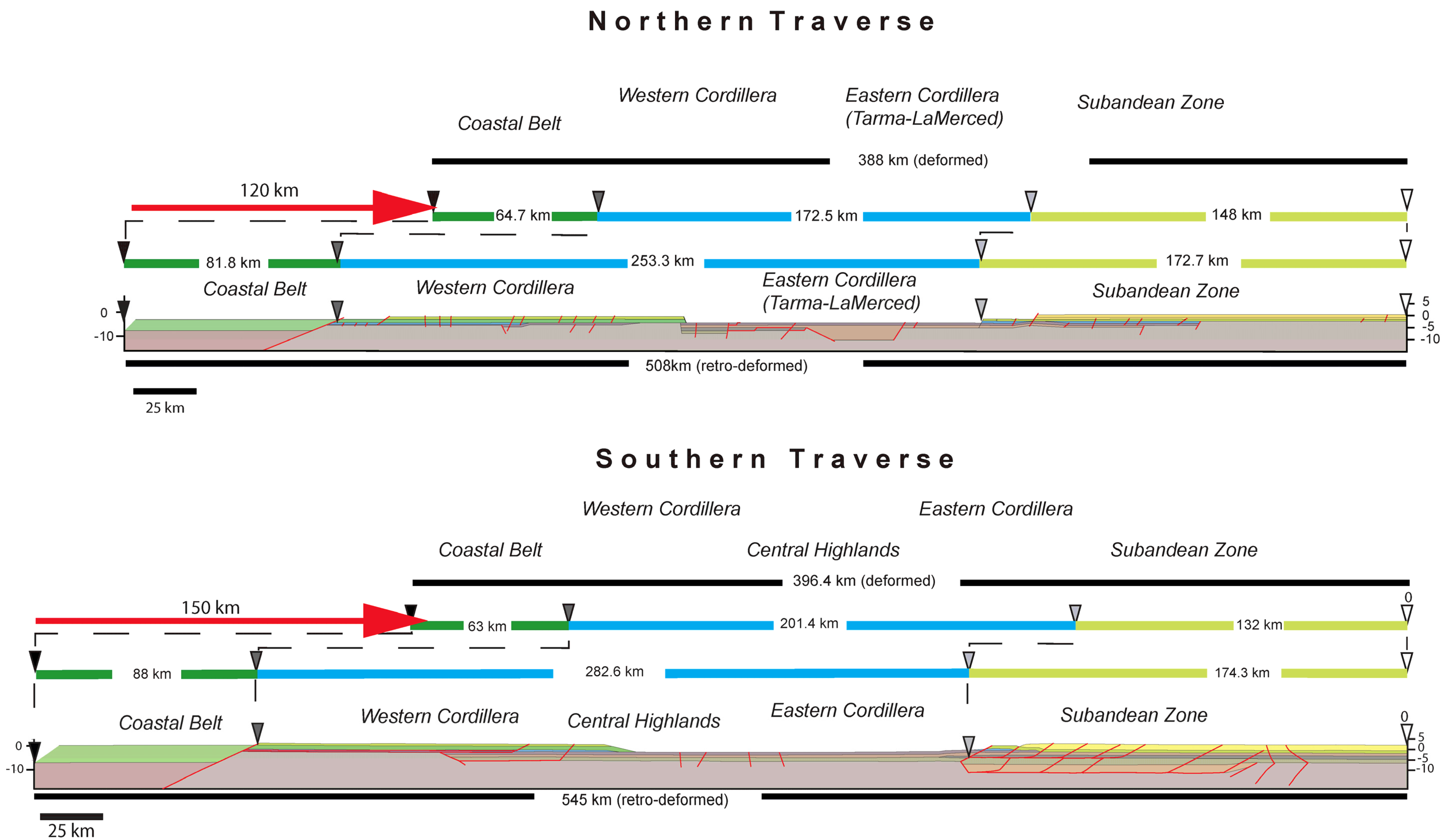
4.2. Balanced Cross-Sections
- (1)
- (2)
- The cross-sections need to be retro-deformable. To achieve this, line length balancing [86] was performed using mechanically strong layers as reference horizons. Owing to significant thickness changes across the orogen, volume balancing is rendered very difficult if not impossible.
- (3)
- (4)
- Displacements along faults must be consistent, i.e., they cannot change without reason. Displacement variations can be caused by stretching and/or shortening in the hanging wall and footwall rocks, or by merging or branching splay faults [90].
- (5)
- In 2D-balancing the trace of the cross-sections should not cross faults with movements in and out of the cross-section. We could not avoid such circumstances and treated the segments individually.
4.2.1. Southern Traverse

4.2.2. Northern Traverse


5. Structural Evolution
5.1. Mochica Phase

5.2. Inca Phase
5.3. Quechua Phase(s)

5.4. Evolution of the Orogen

6. Discussion
6.1. Structural Style

6.2. Deformation Phases in a Plate Kinematic Framework
6.3. Deformation Phases and Mountain Building
7. Conclusions
Acknowledgments
Conflict of Interest
References
- Barazangi, M.; Isacks, B.L. Spatial distribution of earthquakes and subduction of the Nazca plate beneath South America. Geology 1976, 4, 686–692. [Google Scholar] [CrossRef]
- Jordan, T.; Isacks, B.; Allmendiger, R.; Brewer, J.; Ramos, V.; Ando, C. Andean tectonics related to geometry of subducted Nazca plate. Geol. Soc. Am. Bull. 1983, 94, 341–361. [Google Scholar] [CrossRef]
- Ramos, V. Plate tectonic setting of the Andean Cordillera. Episodes 1999, 22, 183–190. [Google Scholar]
- Suarez, G.; Gagnepain, J.; Cisternas, A.; Hatzfeld, D.; Molnar, P.; Ocola, L.; Roecker, S.W.; Viode, J.P. Tectonic deformation of the Andes and the configuration of the subducted slab in central Peru: Results from microseismic experiment. Geophys. J. Int. 1990, 103, 1–12. [Google Scholar] [CrossRef]
- Lindo, R.; Dorbath, C.; Cisternas, A.; Dorbath, L.; Ocola, L.; Morales, M. Subduction geometry in central Peru from a microseismicity survey: First results. Tectonophysics 1992, 205, 23–29. [Google Scholar] [CrossRef]
- Ramos, V.A.; Folguera, A. Andean Flat-Slab Subduction through Time. Geol. Soc. Lond. Spec. Publ. 2009, 327, 31–54. [Google Scholar] [CrossRef]
- Gonzalez, L.; Pfiffner, O.A. Morphologic evolution of the Central Andes of Peru. Int. J. Earth Sci. 2012, 101, 307–321. [Google Scholar] [CrossRef]
- Fukao, Y.; Yamamoto, A.; Kono, M. Gravity anomaly across the Peruvian Andes. J. Geoph. Res. B 1989, 97, 3867–3890. [Google Scholar] [CrossRef]
- Tassara, A.; Götze, H.-J.; Schmidt, S.; Hackney, R. Three-dimensional density model of the Nazca plate and the Andean continental margin. J. Geoph. Res. 2006, 111, B09404:1–B09404:26. [Google Scholar]
- Cardona, A.; Cordani, U.G.; Ruiz, J.; Valencia, V.A.; Armstrong, R.; Chew, D.; Nutman, A.; Sanchez, A.W. U–Pb zircon geochronology and Nd isotopic signatures of the pre-mesozoic metamorphic basement of the Eastern Peruvian Andes: Growth and provenance of a Late Neoproterozoic to carboniferous accretionary orogen on the northewest margin of Gondwana. J. Geol. 2009, 117, 285–305. [Google Scholar] [CrossRef]
- Chew, D.; Schaltegger, U.; Miškovič, A.; Fontignie, D.; Frank, M. Deciphering the Tectonic Evolution of the Peruvian Segment of the Gondwana Margin. In Géodynamique Andine: Résumés Étendus = Andean Geodynamics: Extended Abstracts = Geodinamica Andina: Resumenes Ampliados; Institut de Recherche pour le Développement (IRD): Barcelona, Spain, 2005; pp. 166–169. [Google Scholar]
- Chew, D.; Magna, T.; Kirkland, C.; Miškovič, A.; Cardona, A.; Schaltegger, U.; Spikings, R. Detrital zircon fingerprint of the Proto-Andes: Evidences for a Neoproterozoic active margin? Precambrian Res. 2008, 167, 186–200. [Google Scholar] [CrossRef]
- James, D.E.; Snoke, J.A. Structure and tectonics in the region of flat subduction beneath central Peru: Crust and uppermost mantle. J. Geophys. Res. B 1994, 99, 6899–6912. [Google Scholar] [CrossRef]
- Krabbenhöft, A.; Bialas, J.; Kopp, H.; Kukowski, N.; Hübscher, C. Crustral structure of the Peruvian continental margin from wide-angle seismic studies. Geophys. J. Int. 2004, 159, 749–764. [Google Scholar] [CrossRef]
- Shackelton, M.R.; Ries, A.C.; Coward, M.P.; Cobbold, P.R. Structure, metamorphism and geochronology of the Arequipa Massif of coastal Peru. J. Geol. Soc. Lond. 1979, 136, 195–214. [Google Scholar] [CrossRef]
- Steinmann, M. Geologie von Peru [in German]; Karl Winter Verlag: Heidelberg, Germany, 1929. [Google Scholar]
- Mégard, F. Etude Géologique des Andes du Pérou Central: Contribution à l’Étude Géologique des Andes No 1 [in French]; Mémoires 86; ORSTOM: Paris, France, 1978. [Google Scholar]
- Mégard, F. The Andean orogenic period and its major structures in central and northern Peru. J. Geol. Soc. Lond. 1984, 1, 893–900. [Google Scholar] [CrossRef]
- Jaillard, E.; Soler, P. Cretaceous to Early Paleogene tectonic evolution of the northern Central Andes (0–18° S) and its relation to geodynamics. Tectonophysics 1996, 259, 47–53. [Google Scholar]
- Jaillard, E.; Hérail, G.; Monfret, T.; Díaz-Martínez, E.; Baby, P.; Lavenu, A.; Dumont, J.F. Tectonic Evolution of the Andes of Ecuador, Peru, Bolivia and Northernmost Chile. In Tectonic Evolution of South America, Proceedings of 31st International Geological Congress, Rio de Janeiro, Brazil, 6–17 August 2000; FINEP; Fundo Setorial de Petróleo e Gás Natural: Rio de Janeiro, Brazil; pp. 481–559.
- Soler, P.; Bonhomme, M.G. Relation of Magmatic Activìty to Plate Dynamics ìn Central Peru from Late Cretaceous to Present. In Plutonism from Antarctica to Alaska; Special Paper 241; Kay, S.M., Rapela, C.W., Eds.; Geological Society of America: Boulder, CO, USA, 1990; pp. 173–192. [Google Scholar]
- Espurt, N.; Brusset, S.; Baby, P.; Hermoza, W.; Bolaños, R.; Uyen, D.; Déramond, J. Paleozoic structural controls on shortening transfer in the Subandean foreland thrust system, Ene and southern Ucayali basins, Peru. Tectonics 2008, 27, 1–21. [Google Scholar]
- Gil, W.F. Evolución Lateral de la Deformación de un Frente Orogénico: Ejemplo de las Cuencas Subandinas Entre 0° y 16° [in Spanish]; Publicación Especial 4; Sociedad Geológica del Perú: Lima, Peru, 2002. [Google Scholar]
- Carlier, G.; Gradin, G.; Laubacher, G.; Marocco, R.; Mégard, F. Present knowledge of the magmatic evolution of the eastern cordillera of Peru. Earth Sci. Rev. 1982, 18, 253–283. [Google Scholar] [CrossRef]
- Schaltegger, U.; Chew, D.; Miškovič, A. Neoproterozoic to Early Mesozoic Evolution of the Western Gondwana Margin: Evidence from the Eastern Cordillera of Peru. In Proceedings of XIII Congreso Peruano de Geología, Lima, Peru, 17–20 October 2006.
- Wilson, J. Cretaceous stratigraphy of the central Andes of Peru. AAPG Bull. 1963, 47, 1–34. [Google Scholar]
- Jacay, J.; Castillo, J.; Reátegui, T.; Pari, H. Carácterísticas sedimentológicas del Albiano (Grupo Casma)—Valle del Rio Chillon [in Spanish]. Revista Inst. Investig. Fac. Geol. Minas Metal. Cienc. Geogr. 2002, 5, 43–46. [Google Scholar]
- Aleman, A.M. Stratigraphy, Sedimentology and Tectonic Evolution of the Rio Cañete Basin: Central Coastal Ranges of Peru. In Proceedings of the 3rd International Symposium of Andean Geodynamics (ISAG), St Malo, France, 17–19 September 1996; pp. 261–264.
- Cobbing, E.J. The Tectonic Setting of the Peruvian Andes. In Magmatism at a Plate Edge: The Peruvian Andes; Pitcher, W.S., Atherton, M.P., Cobbing, E.J., Beckinsale, R., Eds.; Blackie and Son Ltd: Glasgow and London, UK; John Wiley and Sons: New York, NY, USA, 1985; pp. 3–12. [Google Scholar]
- Polliand, M.; Schaltegger, U.; Frank, M.; Fontbotè, L. Formation of intra-arc volcano sedimentary basins in the western flank of the Peruvian Andes during Late Cretaceous oblique subduction: Field evidence and constrains from U–Pb ages and Hf isotopes. Int. J. Earth Sci. 2005, 94, 231–242. [Google Scholar] [CrossRef]
- Atherton, M.; Webb, S. Volcanic facies, structure and geochemistry of the marginal basin rocks of Central Peru. J. South. Am. Earth Sci. 1989, 2, 241–261. [Google Scholar] [CrossRef]
- Jacay, J.; Sempere, T. Emplacement Levels of the Coastal Batholith in Central Peru. In Proceedings of the 6th International Sympposium of Andean Geodynamics (ISAG), Barcelona, Spain, 12–14 September 2005; pp. 397–399.
- Dalmayrac, B.; Laubacher, G.; Marocco, R.; Martínez, C.; Tomasi, P. La chaîne hercynienne d’amérique du sud: Structure et évolution d’un orogène intracratonique [in French]. Geol. Rundsch. 1971, 69, 1–21. [Google Scholar]
- Mégard, F.; Caldas, J.; Paredes, J.; De la Cruz, N. Geología de los Cuadrángulos de Tarma, La Oroya y Yauyos [in Spanish]; Bolletin 69; Instituto Geológico Minero y Metalúrgico del Perú: Lima, Peru, 1996; Mapas: 23-l, 24-l, 25-l, Scale 1:100,000. [Google Scholar]
- Scherrenberg, A.F.; Jacay, J.; Holcombe, R.J.; Rosenbaum, G. Stratigraphic variations across the Marañon Fold-Thrust Belt, Peru: Implications for the basin architecture of the West Peruvian Trough. J. South. Am. Earth Sci. 2012, 38, 147–158. [Google Scholar] [CrossRef]
- Szekely, T.; Grose, L.T. Stratigraphy of the Carbonate, Black Shale, and phosphate of the Pucará Group (Upper Triassic–Lower Jurassic), Central Andes, Peru. Geol. Soc. Am. Bull. 1972, 83, 407–428. [Google Scholar] [CrossRef]
- Rosas, S.; Fontboté, L.; Tankard, A. Tectonic evolution and paleogeography of the Mesozoic Pucará Basin, central Peru. J. South. Am. Earth Sci. 2007, 24, 1–24. [Google Scholar] [CrossRef]
- Rosas, S.; Fontboté, L. Sedimentology of the Cercapuquio and Chaucha Formations (Central Peru). In Proceedings of the International Symppsoium of Andean Geodynamics (ISAG), Grenoble, France, 15–17 May 1990; pp. 15–17.
- Moulin, N. Facies et Séquences des Dépôts de la Plate-Forme du Jurassique Moyen à l’Albien, et une Coupe Structurale des Andes du Pérou Central [in French]. Ph.D. Thesis, Université de Montpellier II, Montpellier, France, 1989. [Google Scholar]
- Jaillard, E.; Arnaud-Vanneau, A. The Cenomanian-Turonian transition on the Peruvian margin. Cretac. Res. 1993, 14, 585–605. [Google Scholar] [CrossRef]
- Zapata, A.; Sanchez, A.; Carrasco, S.; Cardona, A.; Galdos, J.; Cerrón, F.; Sempere, T. The Lower Carboniferous of the Western Edge of Gondwana in Peru and Bolivia: Distribution of Sedimentary Basins and Associated Magmatism. In Proceedings of the 6th International Symposium of Andean Geodynamics (ISAG), Barcelona, Spain, 12–14 September 2005; pp. 817–820.
- Díaz-Martínez, E. Estratigrafía y Paleogeografía del Paleozoico Superior del Norte de los Andes Centrales (Bolivia y sur del Perú) [in Spanish]. In 75 Aniversario Sociedad Geológica del Perú, Lima; Macharé, J., Benavides, V., Rosas, S., Eds.; Sociedad Geológica del Perú: Lima, Peru, 1999; Volume 5, pp. 19–26. [Google Scholar]
- Jacay, J.; Castillo, E.; Güimac, K. Sedimentary Evolution of Paleozoic Lithostratigraphic Units in Central Peru (Ambo-Huanuco Region). In Proceedings of the 4th European Meeting on the Palaeontology and Stratigraphy of Latin America, Madrid, Spain, 12–14 September 2007. Cuadernos. del Museo Geominero; Volume 8, pp. 219–221.
- Newell, N.D.; Tafur, I. Ordovícico fosilífero en la Selva oriental del Perú [in Spanish]. Bol. Soc. Geol. Perú. 1943, 14, 5–16. [Google Scholar]
- Jacay, J.; Sempere, T.; Carlier, G.; Carlotto, V. Late Paleozoic-Early Mesozoic Plutonism and Related Rifting in the Eastern Cordillera of Peru. In Proceedings of the 4th International Symposium of Andean Geodynamics (ISAG), Göttingen, Germany, 4–6 October 1999; pp. 350–362.
- Miškovič, A.; Spikings, R.; Chew, D.M.; Košler, J.; Ulianov, A.; Schaltegger, U. Tectonomagmatic evolution of Eastern Amazonia: Geochemical characterization and zircon U–Pb geochronologic constraints from the Peruvian Eastern Cordillera granitoids. Geol. Soc. Am. Bull. 2009, 121, 1298–1324. [Google Scholar] [CrossRef]
- Mathalone, J.M.P.; Montoya, R.M. Petroleum Geology of the Sub Andean Basins of Peru. In Petroleum Basins of South America; Memoir 62l; Tankard, A.J., Suárez Soruco, R., Welsink, H.J., Eds.; American Association of Petroleum Geologists: Tulsa, OK, USA, 1995; pp. 423–444. [Google Scholar]
- Kummel, B. Geological reconnaissance of the Contaman region Peru. Geol. Soc. Am. Bull. 1948, 59, 1217–1266. [Google Scholar]
- Jacques, J.M. A tectonostratigraphic synthesis of the Sub-Andean basins: Implications for the geotectonic segmentation of the Andean Belt. J. Geol. Soc. Lond. 2003, 160, 687–701. [Google Scholar] [CrossRef]
- Hermoza, W.; Brusset, S.; Baby, P.; Gil, W.; Roddaz, M.; Guerrero, N.; Bolaños, M. The Huallaga foreland basin evolution: Thrust propagation in a deltaic enviroment, northen Peruvian Andes. J. South. Am. Earth Sci. 2005, 19, 21–34. [Google Scholar] [CrossRef]
- Pitcher, W.S. The anatomy of a batholith. J. Geol. Soc. Lond. 1978, 135, 157–182. [Google Scholar] [CrossRef]
- Pitcher, W.S.; Atherton, M.P.; Cobbing, E.J.; Beckinsale, R.D. Magmatism at a Plate Edge: The Peruvian Andes; Blackie and Son ltd: Glasgow and London, UK; John Wiley and Sons: New York, NY, USA, 1985. [Google Scholar]
- Cobbing, E.J.; Pitcher, W.S.; Wilson, J.J.; Baldock, J.W.; Taylor, W.P.; McCourt, W.; Snelling, N.J. The Geology of the Western Cordillera of Northern Peru; Institute of Geological Sciences Overseas Memoir 5; Her Majesty’s Stationery Office: Norwich, UK, 1981.
- Chew, D.; Schaltegger, U.; Kosler, J.; Whitehouse, M.J.; Gutjahr, M.; Spikings, R.; Miškovič, A. U–Pb geochronologic evidence for the evolution of the Gondwana margin of the north-central Andes. Geol. Soc. Am. Bull. 2007, 119, 697–771. [Google Scholar] [CrossRef]
- Miškovič, A.; Schaltegger, U. Crustal growth along non-collisional cratonic margin: A Lu-Hf isotopic survey of the Eastern Cordillera granitoids of Peru. Earth Planet. Sci. Lett. 2009, 279, 303–315. [Google Scholar] [CrossRef]
- Lancelot, J.R.; Laubacher, G.; Marocco, R.; Reanud, U. U/Pb radiochronology of two granitic plutons from the eastern cordillera (Peru): Extent of Permian magmatic activity and consequences. Geol. Rundsch. 1978, 67, 236–243. [Google Scholar] [CrossRef]
- Soler, P.; Bonhomme, M.G.; Laubacher, G. Edades K-Ar de Rocas Intrusivas de la Región de Comas-Satipo (Cordillera oriental del Perú Central, implicaciones tectónicas) [in Spanish]. Bol. Soc. Geol. Perú. 1990, 81, 121–125. [Google Scholar]
- Kontak, D.; Clark, A.; Farrar, E.; Strong, D. The Rift-Associated Permo-Triassic Magmatism of the Eastern Cordillera: A Precursor to the Andean Orogeny. In Magmatism at a Plate Edge: The Peruvian Andes; Pitcher, W.S., Atherton, M.P., Cobbing, E.J., Beckinsale, R.B., Eds.; Blackie and Son Ltd: Glasgow and London, UK; John Wiley and Sons: New York, NY, USA, 1985; pp. 3–12. [Google Scholar]
- Atherton, M.P.; Sanderson, M.L.; Wander, V.; McCourt, W. The Volcanic Cover: Chemical Composition and the Origin of the Magmas of the Calipuy Group. In Magmatism at a Plate Edge: The Peruvian Andes; Pitcher, W.S., Atherton, M.P., Cobbing, E.J., Beckinsale, R., Eds.; Blackie and Son Ltd: Glasgow and London, UK; John Wiley and Sons: New York, NY, USA, 1985; pp. 273–284. [Google Scholar]
- Mukasa, S.B.; Tilton, G.R. Zirkon U–Pb Ages of Super-Units in the Coastal Batholith, Peru. In The Nature and Origin of Granite; Pitcher, W.S., Ed.; Chapman and Hall: London, UK, 1985; pp. 203–207. [Google Scholar]
- Mukasa, S.B. Zirkon U–Pb ages of super-units in the Coastal batholith, Peru: Implications for magmatic and tectonic processes. Geol. Soc. Am. Bull. 1986, 97, 241–254. [Google Scholar] [CrossRef]
- Bussell, M.A.; Pitcher, W.S. The Structural Controls of Batholith Emplacement. In Magmatism at a Plate Edge: The Peruvian Andes; Pitcher, W.S., Atherton, M.P., Cobbing, E.J., Beckinsale, R., Eds.; Blackie and Son Ltd: Glasgow and London, UK; John Wiley and Sons: New York, NY, USA, 1985; pp. 167–176. [Google Scholar]
- Cobbing, E.J.; Pitcher, M.P. The Coastal Batholith of Central Peru. J. Geol. Soc. Lond. 1972, 128, 421–460. [Google Scholar] [CrossRef]
- Atherton, M.P.; Sanderson, M.L. The Chemical Variation and Evolution of the Super-Units of the Segmented Coastal Batholith. In Magmatism at a Plate Edge: The Peruvian Andes; Pitcher, M.P., Atherton, W.S., Cobbing, E.J., Beckinsale, R.B., Eds.; Blackie and Son Ltd: Glasgow and London, UK; John Wiley and Sons: New York, NY, USA, 1985; pp. 208–227. [Google Scholar]
- Pitcher, W.S. Cordilleran-Type Batholiths: Magmatism and Crust Formation at a Plate Edge. In The Nature and Origin of Granite; Pitcher, W.S., Ed.; Chapman and Hall: London, UK, 1997; pp. 231–257. [Google Scholar]
- McCourt, W.J. The geochemistry and petrography of the Coastal Batholith of Peru. J. Geol. Soc. Lond. 1981, 138, 407–420. [Google Scholar] [CrossRef]
- Mukasa, S.B. Common Pb isotopic composition of the Lima, Arequipa and Toquepala segments in the Coastal Batholith, Peru: Implications for magma genesis. Geochim. Cosmochim. Acta 1986, 50, 771–782. [Google Scholar] [CrossRef]
- Haederle, M.; Atherton, M.P. Shape and intrusion of the Coastal Batholith, Peru. Tectonophysics 2002, 345, 17–28. [Google Scholar] [CrossRef]
- Bissig, T.; Ullrich, T.; Tosdal, R.; Friedman, R.; Ebert, S. The time-space distribution of Eocene to Miocene magmatism in the central Peruvian polymetallic province and its metallogenetic implications. J. South. Am. Earth Sci. 2008, 26, 16–35. [Google Scholar] [CrossRef]
- Petford, N.; Atherton, M.P. Granitoid emplacement and deformation along a major crustal lineament: The Cordillera Blanca, Peru. Tectonophysics 1992, 205, 17–185. [Google Scholar]
- Petford, N.; Atherton, M. Na-rich partial melts from newly underplated basaltic crust: The cordillera blanca batholith Peru. J. Petrol. 1996, 37, 1491–1521. [Google Scholar] [CrossRef]
- Petford, N.; Atherton, M.P.; Halliday, A.N. Rapid magma production rates, underplating and remelting in the Andes: Isotopic evidence from northern-central Peru (9°–11° S). J. South. Am. Earth Sci. 1996, 9, 69–78. [Google Scholar] [CrossRef]
- Farrar, E.; Noble, D.C. Timing of late Tertiary deformation in the Andes of Peru. Geol. Soc. Am. Bull. 1976, 87, 1247–1250. [Google Scholar] [CrossRef]
- Noble, D.C.; McKee, E.; Mégard, F. Early Tertiary “Incaic” tectnonism, uplift, and volcanic activity, Andes of Central Peru. Geol. Soc. Am. Bull. 1979, 90, 903–907. [Google Scholar] [CrossRef]
- McKee, E.H.; Noble, D.C. Miocene volcanism and deformation in the western Cordillera and high plateaus of south-central Peru. Geol. Soc. Am. Bull. 1982, 93, 657–662. [Google Scholar] [CrossRef]
- Wise, J.M.; Noble, D.C.; Zanetti, K.A.; Spell, T.L. Quechua II contraction in the Ayacucho intermontane basin: Evidence for rapid and episodic Neogene deformation in the Andes of central Perú. J. South. Am. Earth Sci. 2008, 26, 383–393. [Google Scholar] [CrossRef]
- Trumbull, R.B.; Riller, U.; Oncken, O.; Scheuber, E.; Munier, K.; Hongn, F. The Time-Space Distribution of Cenozoic Volcanism in the South-Central Andes: A New Data Compilation and Some Tectonic Implications. In The Andes–Active Subduction Orogeny; Frontiers in Earth Sciences Series 1; Oncken, O., Chong, G., Franz, G., Götze, H.-J., Ramos, V.A., Strecker, M.R., Wigger, P., Eds.; Springer: Berlin, Germany, 2006; pp. 29–44. [Google Scholar]
- Angeles, C. Le chevauchements de la Cordillère Occidentala par 12°15' S (Andes du Péru Central) [in French]. Ph.D. thesis, Universite de Montpellier II, Montpellier, France, 1987. [Google Scholar]
- Sempere, T.; Jacay, J.; Carlotto, V.; Martinez, W.; Bedoya, C.; Fornari, M.; Roperch, P.; Acosta, H.; Acosta, J.; Cerpa, L.; et al. Sistemas Transcurrentes de Escala Litosférica en el sur del Perú [in Spanish]. In Nuevas Contribuciones del IRD y sus Contrapartes al Conocimiento Geológico del sur del Perú; Publicación Especial 5; Jacay, J., Sempere, T., Eds.; Sociedad Geológica del Perú: Lima, Peru, 2004; pp. 105–110. [Google Scholar]
- Jacay, J. Análisis de la Sedimentación del Sistema Cretáceo de los Andes del Perú Central [in Spanish]. Revista Inst. Investig. Fac. Geol. Minas Metal. Cienc. Geogr. 2005, 8, 49–59. [Google Scholar]
- Mégard, F.; Dalmayrac, B.; Laubacher, G.; Marocco, R.; Martinez, C.; Paredes, J.; Tomasi, P. La Chaine Hercynienne au Pérou et en Bolivie, premiers résultats [in French]. Cah. Orstom Sér. Géol. 1971, 3, 5–44. [Google Scholar]
- Dorbath, C.; Dorbath, L.; Cisternas, A.; Deverchère, J.; Sebrier, M. Seismicity of the Huancayo Basin (Central Peru) and the Huaytapallana Fault. J. South. Am. Earth Sci. 1990, 3, 21–29. [Google Scholar] [CrossRef]
- Dorbath, L.; Dorbath, C.; Jimenez, E.; Rivera, L. Seismicity and tectonic deformation in the Eastern Cordillera and the sub-Andean zone of central Peru. J. South. Am. Earth Sci. 1991, 4, 13–24. [Google Scholar] [CrossRef]
- Soler, P.; Rotach-Toulhoat, N. Sr-Nd isotope compositions of cenozoic granitoids along a traverse of the central Peruvian Andes. Geol. J. 1990, 25, 351–358. [Google Scholar] [CrossRef]
- Pfiffner, O.A. Thick-Skinned and Thin-Skinned Styles of Continental Contraction. In Styles of Continental Contraction; Special Paper 414; Mazzoli, S., Butler, R.W.H., Eds.; Geological Society of America: Boulder, CO, USA, 2006; pp. 153–177. [Google Scholar]
- Dahlstrom, C.D.A. Balanced cross sections. Can. J. Earth Sci. 1969, 6, 743–757. [Google Scholar] [CrossRef]
- Boyer, S.; Elliot, D. Thrust Systems. AAPG Bull. 1982, 66, 1196–1230. [Google Scholar]
- Dahlstrom, C.D.A. Geometric constrains derived from the law of conservation of volume and applied to evolutionary models for detachment folding. AAPG Bull. 1990, 74, 336–344. [Google Scholar]
- Jamison, W.R. Geometric analysis of fold development in overthrust terranes. J. Struct. Geol. 1987, 9, 207–219. [Google Scholar]
- Pfiffner, O.A. Displacements along thrust faults. Eclogae Geologicae Helvetiae 1985, 78, 313–333. [Google Scholar]
- Mégard, F. Structure and Evolution of the Peruvian Andes. In The Anatomy of Mountain Ranges; Schaer, J.-P., Rodgers, J., Eds.; Princeton University Press: Princeton, NJ, USA, 1987; pp. 179–210. [Google Scholar]
- Laubacher, G.; Naeser, W. Fission-track dating of granitic rocks from the Eastern Cordillera of Peru: Evidence for Late Jurassic and Cenozoic cooling. J. Geol. Soc. Lond. 1994, 151, 473–483. [Google Scholar] [CrossRef]
- Sandeman, H.; Clark, A.; Farrar, E. An Integrated Tectono-Magmatic Model for the evolution of the Southern Peruvian Andes (13°–20°) since 55 Ma. Int. Geol. Rev. 1995, 37, 1039–1073. [Google Scholar] [CrossRef]
- McNulty, B.; Farber, F. Active detachment faulting above the Peruvian flat slab. Geology 2002, 30, 567–570. [Google Scholar] [CrossRef]
- Berger, A.; Rosenberg, C.; Schmid, S.M. Ascent, emplacement and exhumation of the Bergell pluton within the Southern Steep Belt of the Central Alps. Schweiz. Mineral. Petrogr. Mitt. 1996, 76, 357–382. [Google Scholar]
- Dalmayrac, B.; Molnar, P. Parallel thrust and normal faulting in Peru and constraints on the state of stress. Earth Planet. Sci. Lett. 1981, 55, 473–481. [Google Scholar] [CrossRef]
- Schwartz, D.P. Paleoseismicity and neotectonics of the Cordillera Blanca fault zone, northern Peruvian Andes. J. Geophys. Res. B. 1988, 93, 4712–4730. [Google Scholar] [CrossRef]
- Allmendinger, R.W.; Smalley, R., Jr; Bevis, M.; Caprio, H.; Brooks, B. Bending the Bolivian orocline in real time. Geology 2005, 33, 905–908. [Google Scholar] [CrossRef]
- Oncken, O.; Hindle, D.; Kley, J.; Elger, K.; Victor, P.; Schemmann, K. Deformation of the Andean Upper Plate System–Facts, Fiction, and Constraints for Modellers. In The Andes–Active Subduction Orogeny; Frontiers in Earth Sciences Series 1; Oncken, O., Chong, G., Franz, G., Götze, H.-J., Ramos, V.A., Strecker, M.R., Wigger, P., Eds.; Springer: Berlin, Germany, 2006; pp. 3–28. [Google Scholar]
- Pilger, R. Plate reconstruction, aseismic ridges, and low-angle subduction beneath the Andes. Geol. Soc. Am. Bull. 1981, 92, 448–456. [Google Scholar] [CrossRef]
- Pardo-Casas, F.; Molnar, P. Relative motion of the Nazca (Farallon) and South American Plates since Late Cretaceous time. Tectonics 1987, 6, 233–248. [Google Scholar] [CrossRef]
- Sdrolias, M.; Müller, R.D. Controls on back-arc basin formation. Geochem. Geophys. Geosyst. 2006, 7, Q04016:1–Q04016:40. [Google Scholar]
- Oncken, O.; Boutelier, D.; Dresen, G.; Schemmann, K. Strain accumulation controls failure of a plate boundary zone: Linking deformations of the Central Andes and lithosphere mechanics. Geochem. Geophys. Geosyst. 2012, 13, Q12007:1–Q12007:22. [Google Scholar]
- Kley, J. Geologic and geometric constraints on a kinematic model of the Bolivian orocline. J. South. Am. Earth Sci. 1999, 12, 221–235. [Google Scholar] [CrossRef]
- McQuarry, N.; DeCelles, P.G. Geometry and structural evolution of the central Andean backthrust belt, Bolivia. Tectonics 2001, 20, 669–692. [Google Scholar] [CrossRef]
- McQuarry, N.; Davis, G.H. Crossing the several scales of strain-accomplishing mechanisms in the hinterland of the central Andean fold-thrust belt, Bolivia. J. Struct. Geol. 2002, 24, 1587–1602. [Google Scholar] [CrossRef]
- Kley, J.; Monaldi, C.R.; Salfity, J.A. Along-strike segmentation of the Andean foreland: Causes and consequences. Tectonophysics 1999, 301, 75–94. [Google Scholar] [CrossRef]
- Gotberg, N.; McQuarrie, N.; Caillaux, V.C. Comparison of crustal thickening budget and shortening estimates in southern Peru (12°–14° S): Implications for mass balance and rotations in the “Bolivian orocline”. Geol. Soc. Am. Bull. 2010, 122, 727–742. [Google Scholar] [CrossRef]
- Sempere, T.; Jacay, J. Anatomy of the Central Andes: Distinguishing between Western, Magmatic Andes and Eastern, Tectonic Andes. In Proceedings of the 7th International Symposium of Andean Geodynamics (ISAG), Nice, France, 2–4 September 2008; pp. 505–507.
- Hampel, A.; Pfiffner, A. Relative Importance of Trenchward Upper Plate Motion and Friction along the Plate Interface for the Topographic Evolution of Mountain Belts. In Analogue and Numerical Modelling of Crustal-Scale Processes; Special Publication 253; Buiter, S.J.H., Schreurs, G., Eds.; The Geological Society: London, UK, 2006; pp. 105–115. [Google Scholar]
- Silver, P.; Russo, R.; Lithgow-Bertelloni, C. Coupling of the south American and African plate motion and plate deformation. Science 1998, 129, 60–63. [Google Scholar]
- Ramos, V.A.; Aleman, A. Tectonic Evolution of the Andes. In Tectonic Evolution of South America, Proceedings of 31st International Geological Congress, Rio de Janeiro, Brazil, 6–17 August 2000; Cordani, U.G., Milani, E.J., Thomaz, A., Campos, D.A., Eds.; FINEP; Fundo Setorial de Petróleo e Gás Natural: Rio de Janeiro, Brazil; pp. 635–685.
- Von Huene, R.; Scholl, D.W. Observations at convergent margins concerning sediment subduction, subduction erosion, and the growth of continental crust. Rev. Geophys. 1991, 29, 279–316. [Google Scholar] [CrossRef]
- Von Huene, R.; Pecher, I.A.; Gutscher, M.-A. Development of the accretionary prism along Peru and material flux after subduction of the Nazca Ridge. Tectonics 1996, 15, 19–33. [Google Scholar] [CrossRef]
- Gregory-Wodzicki, K.M. Uplift history of the Central Northern Andes: A review. Geol. Soc. Am. Bull. 2000, 112, 1092–1105. [Google Scholar] [CrossRef]
- Ege, H.; Sobel, E.R.; Scheuber, E.; Jacobshagen, V. Exhumation history of the southern Altiplano plateau (southern Bolivia) constrained by apatite fission track thermochronology. Tectonics 2007, 26, TC1004:1–TC1004:24. [Google Scholar]
- Schildgren, T.F.; Hodges, K.V.; Whipple, K.X.; Reiers, P.W.; Pringle, M.S. Uplift of the western margin of the Andean plateau revealed from canyon incision, southern Peru. Geology 2007, 35, 523–526. [Google Scholar] [CrossRef]
- Thouret, J.C.; Wörner, G.; Gunnell, Y.; Singer, B.; Zahn, X.; Souriot, T. Geochronologic and stratigraphic constrains on canyon incision and Miocene uplift of the Central Andes in Peru. Earth Planet. Sci. Lett. 2007, 263, 151–166. [Google Scholar] [CrossRef]
- Steinmann, M.; Hungerbühler, D.; Seward, D.; Winkler, W. Neogene tectonic evolution and exhumation of the southern Ecuadorian Andes: A combined stratigraphy and fission-track approach. Tectonophys 1999, 307, 255–276. [Google Scholar] [CrossRef]
© 2013 by the authors; licensee MDPI, Basel, Switzerland. This article is an open access article distributed under the terms and conditions of the Creative Commons Attribution license (http://creativecommons.org/licenses/by/3.0/).
Share and Cite
Pfiffner, O.A.; Gonzalez, L. Mesozoic–Cenozoic Evolution of the Western Margin of South America: Case Study of the Peruvian Andes. Geosciences 2013, 3, 262-310. https://doi.org/10.3390/geosciences3020262
Pfiffner OA, Gonzalez L. Mesozoic–Cenozoic Evolution of the Western Margin of South America: Case Study of the Peruvian Andes. Geosciences. 2013; 3(2):262-310. https://doi.org/10.3390/geosciences3020262
Chicago/Turabian StylePfiffner, O. Adrian, and Laura Gonzalez. 2013. "Mesozoic–Cenozoic Evolution of the Western Margin of South America: Case Study of the Peruvian Andes" Geosciences 3, no. 2: 262-310. https://doi.org/10.3390/geosciences3020262