Article

Analysis of the Efficiency of Petroleum Systems in Fluvial Environments in the Rift Context of the South and North Atlantic: Brazil and Portugal

by
Gustavo Santana Barbosa
1,2,
Gustavo Gonçalves Garcia
2,3,4,*,
Rui Paulo Bento Pena dos Reis
2,
Antônio Jorge Vasconcellos Garcia
2,3 and
Gabriel de Alemar Barberes
2
1
Brazilian National Agency for Oil, Gas and Biofuels—ANP, Avenida Rio Branco, 65, Rio de Janeiro 20090-004, Brazil
2
Geosciences Center, Department of Earth Sciences, University of Coimbra, Rua Sílvio Lima, 3030-790 Coimbra, Portugal
3
Nucleus of Competence for Oil, Gas and Biofuels/Progeologia Laboratory, Federal University of Sergipe, Avenida Marechal Rondon S/n, São Cristóvão 49100-000, Brazil
4
Department of Earth Sciences, Science and Technology Faculty, University of Coimbra, Rua Sílvio Lima, 3030-790 Coimbra, Portugal
*
Author to whom correspondence should be addressed.
Geosciences 2023, 13(8), 239; https://doi.org/10.3390/geosciences13080239
Submission received: 13 June 2023 / Revised: 4 August 2023 / Accepted: 7 August 2023 / Published: 10 August 2023
(This article belongs to the Section Sedimentology, Stratigraphy and Palaeontology)

Abstract

:
The present article exhibits the achieved results based on the evaluation of two petroleum systems, which compares reservoirs of fluvial environments of sedimentary basins located in the south and north Atlantic, in Brazil (Recôncavo Basin) and in Portugal (Lusitanian Basin), respectively. The main contribution of this study is the survey of the static (source, reservoir, and sealing rocks, in addition to traps) and dynamic elements (tectonic, migration, thermal, and diagenetic processes) of the two studied petroleum systems, seeking to understand the reasons for the success and failure of the analyzed reservoirs in relation to the accumulation of hydrocarbons. The following materials were used for this study: lithostratigraphic charts, event charts of petroleum systems, interpreted 2D seismic reflection lines, lithological profiles, outcrop data, geochemical analysis of source rocks, petrographic analysis, and description of diagenetic processes, which acts in the reservoir rocks. The methodology presents two phases: the first with a multiscale characterization of the elements of petroleum systems and economic aspects, and another with an integrated analysis of the reservoir potentials, based on the efficiency analysis table of the petroleum system elements and interpretative diagrams of the petroleum system elements. The occurrences of hydrocarbon accumulations indicate that the structuring of the Recôncavo Basin in horsts and grabens provides the formation of efficient migration routes, combined with an excellent source rock, reservoirs with good permo-porous characteristics, and effective seal rocks. On the other hand, in the Lusitanian Basin, the Paleozoic source rocks occur in mini-basins, with little lateral continuity, which negatively affects the generation of hydrocarbons. Besides this fact, saliferous tectonics were the main cause of hydrocarbon migration along faults or their walls towards the upper strata and to the surface. The fluvial reservoir rock shows a strong action of diagenetic processes, which affects its petrophysical properties. The main implication of this work is its contribution to the analysis of analogous reservoirs, based on the detailed investigation of the static and dynamic elements of petroleum systems.

Graphical Abstract

1. Introduction

Based on the traditional concept issued by AAPG Memoir 60 [1], the petroleum system comprises a collection of active source rocks and a set of fundamental elements and procedures for the occurrence of an accumulation of hydrocarbons. The most important elements are the source and reservoir rocks, the seals, and the overburden of the source rock. The development of traps and the generation–migration–accumulation of hydrocarbons make up the essential processes associated with static elements. For an accumulation of hydrocarbons to exist, it is fundamental that all the essential elements must be synchronized in time and space. The presence of a petroleum system is given by the occurrence of hydrocarbons, characterized by a drop of oil or an emanation of gas (low volume, but with high concentration).
The static elements of petroleum systems [2] essentially constitute the elements that can be mapped, through seismic and petrophysical profiles, and are related to sedimentary processes (depositional systems, involving aspects such as erosion/climate, and accumulation and preservation rates), namely, the source rock, the reservoir rock, and the seal rock. A fourth equally mappable element is the trap, which develops in association with depositional history (stratigraphic traps), diagenesis (diagenetic traps), or post-depositional tectonics (structural and geomorphic traps). The elements of the petroleum systems that we can model are the dynamic ones [2]. They are those associated with post-depositional dynamics, which encompass: migration–accumulation, tectonic processes (history of burial or subsidence and associated overload, sedimentation rate, and uplift), and diagenetic and thermal processes (heat flows). All these dynamic elements may influence the different petrophysical properties and permo-porous attributes of the reservoir rocks, and, consequently, their accumulation potentials. The geodynamic elements directly influence the static elements during the development of each sedimentary basin. These geodynamic elements include tectonic processes (uplift and subsidence history, uplift, and subsidence indices), and diagenetic and thermal processes (heat flows). Consequently, uplift and subsidence control the specific petrophysical properties of each analyzed reservoir rock, impacting its chance of exploratory success and its possibility of forming commercial oil and gas accumulations. The dynamic elements are directly influenced by the geodynamic processes acting in a basin. In this, in turn, every sedimentary package performs a functional and decisive task in the formation, detention, and preservation of oil and gas. A petroleum system is established through the continuity of chemical and physical processes, such as diagenesis, tectonics, compression, etc. These processes act on the strata, influencing the formation, accumulation, and dissemination of hydrocarbons. Fundamental aspects that regulate these modifications and originate them are the geodynamic mechanisms of sinking and rising of the basin, in accordance with tectonic movements, geothermal flows, and gravitational force [3].
This article seeks to understand the differences in the evolution of each studied sedimentary basin, and places analogous reservoir formations (deposited in similar sedimentary contexts and tectonic stage, and equivalent basins from the point of view of the geotectonic context) in a situation of success or exploratory failure (economic success). In this context, the case study compares similar fluvial reservoirs from the Recôncavo Basin (Sergi Formation—Upper Jurassic), in Brazil, with those from the Lusitanian Basin (Grés de Silves Group—Triassic), in Portugal.
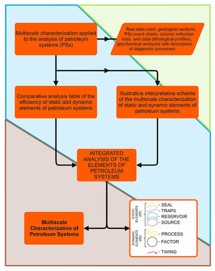
This study was carried out based on the multiscale characterization of the static and dynamic elements of the two studied petroleum systems. The following data were used in this study: lithostratigraphic charts, petroleum systems events charts, interpreted 2D seismic reflection lines, lithological profiles, outcrop data, geochemical analysis of source rocks, petrographic analysis, and description of diagenetic processes active in reservoir rocks.
The methodology proposed in this article was the same used in the work published in November 2022, entitled “Petroleum Systems Analysis of Turbidite Reservoirs in Rift and Passive margin Atlantic Basins (Brazil and Portugal)” [4], written by the same authors. The adopted methodology may be divided into two phases: the first is a multiscale characterization of the static and dynamic elements of the petroleum systems and economic aspects; and the second presents an integrated analysis, based on the efficiency analysis table of the petroleum system elements, in addition to interpretative diagrams showing the static and dynamic elements of the two studied petroleum systems.
In the Recôncavo Basin, its strata are structured in horsts and grabens, which provide the development of effective migration routes and both structural and stratigraphic traps. In addition to this, the basin has an excellent source rock, in thickness and generation capacity, as well as a reservoir with good permo-porous characteristics, and efficient seal rocks. At the Lusitanian Basin, the little lateral continuity of the Paleozoic generating mini-basins, results in small volumes of source rocks. Furthermore, the huge impact of saline diapirs results in the migration of hydrocarbons along the faults or along their walls, towards the upper formations and the surface. The analysis of the properties in different scales of multiscale characterization allowed the confirmation of the presence of active petroleum systems, attesting to the occurrence of the four static elements, as well as the dynamic elements generation and migration, in both studied petroleum systems.
Limitations of this study were the use of old and poor quality data from exploratory wells in the Lusitanian Basin, as well as the small quantity of petrographic data from the Sesmaria field in the Recôncavo Basin.

2. Geological Settings

The Recôncavo Basin covers an area of 11,500 km2 and consists of a southeastward dipping continental half graben. The basin was developed during the opening of the South Atlantic Ocean (Figure 1), evolving as an aborted rift of the eastern Brazilian continental margin. The basin fill of the Recôncavo Basin is composed of strata deposited during pre-, syn-, and post-rift phases. Upper Paleozoic through Jurassic period pre-rift deposits are mainly red beds and coarse-grained fluvial deposits. Neocomian age syn-rift strata represent the volumetrically most important fill of the basin, and encompass lacustrine (main source rocks) to deltaic to fluvial deposits. Finally, Cretaceous through Cenozoic era post-rift deposits are poorly represented in the basin (about 100 m thick), and are constituted mostly of medium- to coarse-grained alluvial and fluvial sandstones. Total sedimentary thickness along basinal depocenters exceeds 5 km [5].
The Lusitanian Basin is located on the Iberian Margin of the North Atlantic, whose ocean flooring began in the Lower Cretaceous. However, the origin of the Lusitanian Basin, whose basal sediments date from the Upper Triassic epoch, is rooted in a much older geodynamic framework, which began with the Paleozoic continental collisions, continued with the opening and closing of western Tethys, and ended with the opening of the North Atlantic as a result of the breakup of Pangea in the Triassic period (Figure 2). The basin has a filling sedimentary with very variable thicknesses that are greater than 5 km in their depocentric areas, presenting a record ranging from the Late Triassic to the Late Cretaceous epochs, and its ground portion extends for 320 km north–south and 180 km in the east–west [7]. Over the approximately 150 Ma that lasted its evolution, the Lusitanian Basin covered a long paleogeographic path associated with continental drift, from a latitude close to 12° N in the Late Triassic epoch until a latitude close to 30° in the Late Cretaceous epoch (Figure 1) [8].
The Recôncavo Basin is located in northeastern Brazil, in the southern portion of the Recôncavo–Tucano–Jatobá rift, and the Lusitanian Basin is located on the Iberian Margin of the North Atlantic (Figure 3). The stratigraphic charts of both basins and their petroleum systems event charts are presented, covering the two confirmed petroleum systems: Candeias–Sergi and Paleozoic–Grés de Silves.

2.1. Recôncavo Basin—Stratigraphy and Studied Petroleum System

The lithostratigraphic column of the Recôncavo Basin (Figure 4) shows the Candeias–Sergi petroleum system, with the source rocks of the Candeias Formation being enclosed in the orange ellipse and the reservoir rocks of the Sergi Formation being contained in the red ellipse.
The Mesozoic stratigraphy in the Recôncavo–Tucano–Jatobá Rift is the result of the v tectonic evolution of the basin, which can be divided in sequences deposited in the pre-rift, sin-rift, and post-rift phases (Figure 4 and Figure 5). The pre-rift phase occurred between the Late Jurassic and Early Cretaceous epochs. Pre-rift succession extends temporally from the Tithonian to the Eoberriasian age, covering rocks from the Dom João and Rio da Serra Inferior floors. The Dom João Floor consists of alluvial deposits of the Brotas group, represented by reddish shales and sandstones of the Aliança Formation, underlying fluvial and aeolian sandstones of the Sergi Formation. These red beds are succeeded by sediments of the Santo Amaro group, whose basal unit (Itaparica Formation) contains fluvial and lacustrine deposits. Superimposed on these there are fluvial and aeolian sandstones of the Água Grande Formation. The syn-rift succession comprises a shallowing and coarsening-upward mega sequence. During a hungry basin phase, in the depocenters, longitudinal and transverse turbidites of the Gomo member (Candeias Formation, Middle Rio da Serra) were deposited, together with lacustrine shales including successions of laminated and massive sandstones. Then, during the Neo-Rio da Serra, a continuous sedimentation of thick deltaic sandstones exerted a strong overload on the shales of the Maracangalha Formation, pressurizing them and resulting in shale diapirs associated with growth faults (Figure 5). In this last unit, there are thick packages of massive and fluidized sandstones from the Pitanga and Caruaçu members, deposited along the most eastern depocenters of the graben. The decrease in the subsidence rate, in the period that includes the Rio da Serra and Aratu ages, allowed deltas to progress from NNW over existing platforms on the flexural margin of the rift, filling the depocenters with sandstones, siltstones, shales, and occasional carbonates of the group Ilhas, constituted by the Marfim Formation, member Catu, and Pojuca Formation (Figure 5). During Eo Aratu, a tectonically induced drop in lake level originated a canyon in the western portion of the basins of the Tucano Sul and Recôncavo, where the sandstones and shales of the Taquipe Formation accumulated (Figure 5). The deltaic deposits were succeeded by the fluvial sandstones of the São Sebastião Formation, Massacará group, which progressed from NNW to SSE from the Tucano Basin [12].
The principal source rocks of the petroleum system Candeias–Sergi are the lacustrine shales of the Gomo member of the Candeias Formation (Berriasian Rio da Serra stage). The main reservoir rocks are the sandstones of the Sergi Formation (Upper Jurassic Dom João stage).
The studied Candeias–Sergi petroleum system involves the shales from the Tauá and Gomo members of the Candeias Formation [13]. The average TOC content associated with the Candeias shale can reach 4% and the kerogen is type I [14]. The shales of the Itaparica, Candeias (Gomo and Tauá members), Maracangalha, Marfim, and Pojuca Formations are the main seal rocks of the basin.
The positions of the elements and processes of the Candeias–Sergi petroleum system [15] are presented in the events chart (Figure 6).

2.2. Lusitanian Basin—Stratigraphy and Studied Petroleum System

The lithostratigraphic column of the Lusitanian Basin (Figure 7) shows the Paleozoic–Grés de Silves petroleum system, with the source rocks of the Paleozoic era being enclosed in the red ellipse and the reservoir rocks of the Castelo Viegas Formation being contained in the yellow ellipse.
The stratigraphic succession and the tectonic episodes of the Lusitanian Basin are shown in Figure 8, and are fundamental in understanding the filling of the basin in the various stages of the geotectonic context [20]. At the beginning of the Mesozoic (Upper Triassic) era, the Lusitanian Basin differed as a result of the crustal stretching that gave rise to an intra-continental rift groove (Figure 8(1)). This structure rapidly evolved into an epicontinental sea depression, in connection with the domain western Tetisian, following an increase in subsidence in the earliest Lower Jurassic epoch (Figure 8(2–4)). A second extensional event, with a distinct geodynamic control, triggered the Atlantic reorientation of the basin from the Late Jurassic epoch (Figure 8(5,6)), evolving during the Early Cretaceous epoch (Figure 8(7–9)) to a margin passive, along three segments aligned from south to north and temporally successive. From the end of the Cretaceous period, the tectonic inversion of the basin (Figure 8(10)) originated uplift, exposing vast areas of the basin and subsequent erosion, resulting in a significant accumulation of siliciclastic sediments in currently emersed and also immersed zones [21].
In the Paleozoic–Grés de Silves petroleum system of the Lusitanian Basin, the source rocks are represented by silurian and carboniferous shales (Figure 7), with average TOC values around 3% (up to 8%), with types II and III kerogens [22].
The hydrocarbons migrated from the Paleozoic source rocks to the fluvio-eolian sandstones of the Castelo Viegas Formation [23] (Figure 9), through reverse faults. Three exploratory targets tested this Paleozoic–Grés de Silves petroleum system. Two of them were the onshore wells Alcobaça-1 and Aljubarrota-2, drilled on the central part of the Lusitanian Basin, and other was the offshore well 13C-1.
Figure 9 shows the events chart of the Lusitanian Basin, where the Paleozoic–Grés de Silves petroleum system (equivalent to the pre-salt petroleum system) is displayed within the dashed red line.

3. Materials and Methods

3.1. Materials

As materials presented in this article, data obtained by direct observation were used, such as data from exploratory wells (well folders and lithological profiles), geochemical analyzes of source rocks, and petrographic analyzes with interpretation of reservoir rock cores. The data obtained by indirect observation in the present research were the interpreted 2D seismic reflection lines.

3.1.1. Sergi Formation

The location maps of the Sesmaria Field in the Recôncavo Basin [24], of the location of the 2D seismic line 0026-1179, and of the 09 exploratory wells used in this investigation [25] are shown in Figure 10. The 2D seismic line 0026-1179 is presented in the results (item 4), with the location of the well 1-SI-1-BA, as well as the formations and faults interpreted.
In this research, data were used from the following 09 wells: 1-SI-1-BA, 1-SI-2-BA, 3-SI-3-BA, 3-SI-4-BA, 3-SI-9-BA, 3-SI-13-BA, 3-SI-14-BA, 3-SI-21-BA, and 7-SI-10-BA. These wells were drilled on the Sesmaria Field (Figure 10), and had their lithological profiles and well folders downloaded from the “BDEP”—the exploration and production databank from ANP [25].
The exploration well 3-SI-3-BA (indicated by the blue arrow on Figure 10) was chosen to be shown in the final results. Lithology depth information obtained from the lithological profile of exploration well 1-SI-BA was used to interpret the seismic line horizons.
In order to prove the effectiveness of the Candeias Formation shales, the geochemical profiles of the source rock are displayed in the results.
The three thin sections with their respective photomicrographs shown in the results were collected from well 7-SI-10-B cores (indicated by the orange rectangle in Figure 10). They were collected at the following three depths: 2257.2 m, 2328.8 m, and 2332.2 m.

3.1.2. Castelo Viegas Formation—Grés de Silves Group

The map of the central sector of the Lusitanian Basin (Figure 11), showing the position of the interpreted 2D seismic line UTP-82-28 [27], employed in research, and the locations of the exploratory wells Alcobaça-1(Alc-1) and Aljubarrota-2 (Alj-2). The seismic line UTP-82-28 was selected to be shown on the results because it clearly shows the normal fractures that link the shales of the Paleozoic basement with the siliciclastic reservoir rocks of the Castelo Viegas Formation (Late Triassic epoch). The potential Triassic fluvial reservoirs are clearly presented on the lithological profile of the Alcobaça-1 (Alc-1) exploratory well, as shown in the results. This well drilled a total of 587 m of the Grés de Silves group’s rocks (from 2653 m to 3240 m). This profile shows a 587 m range of siliciclastic rocks from the Grés de Silves group (from 3027 m to 3616 m depth), which produced oil at low flow in two production tests (DST-1 and DST-2).
Regarding geochemical analyzes of the source rocks, the organic matter contents (total organic carbon—TOC) in Silurian shales, as well as in Upper Carboniferous shales, are presented in the results. These analyzes attest that the maturation of these source rocks reaches the gas window.
The descriptions and photomicrographs of four thin sections [28] of the Upper Triassic fluvial sandstones (Castelo Viegas Formation—Grés de Silves group), from samples collected in the regions of Praia do Talheiro (TPT) and Santiago do Cacém (TSC), were performed. The locations of these samples are presented in Figure 12, below. The four thin sections are as follows: TPT-01; TSC-01; TSC-05; and TSC-11.

3.2. Methods

As already mentioned, the methodology proposed in this article was the same used in the work published in November 2022, entitled “Petroleum Systems Analysis of Turbidite Reservoirs in Rift and Passive margin Atlantic Basins (Brazil and Portugal)” [4]. The multiscale reservoir characterization method (acronym CAMURES, in Portuguese) [30,31] served as base for the petroleum system multiscale characterization used in this research as the first phase of methodology. This multiscale characterization of the static and dynamic elements of the petroleum system was made based on the presented geological data, in order to prove the evidence of the petroleum systems.
Beyond the multiscale characterization, the probability of geological success (Pg) for each studied reservoir was calculated, completing the first phase of the methodology. To calculate the probability of geological success (Pg), the four factors of the play concept [32] are multiplied, expressed in grades from 0.0 to 1.0, using the following equation:
Pg = P source rock (Psr) × P reservoir (Pr) × P trap (Pt) × P dynamic (Pd)
The definition of geological success can be expressed as the reservoir’s ability to maintain a stable and balanced volume in an oil and gas production inspection, not considering hydrocarbon flows without pressure stabilization or the occurrence of oil and gas shows. This concept discards reservoirs with limited areal extension, biodegraded oils, reservoirs with very low permeability, and other marginal occurrences, which are not capable of offering a stable volume of oil and gas, observed in a success situation [33].
After an approximate assessment of the probability of the geological factors, the probability of geological success is calculated by the equation presented and, consequently, the value of the geological risk. The estimated values for each of the geological factors come from the knowledge of the multiscale database (data from different scales) of the studied petroleum system. Based on these assumptions, the probability of geological success (Pg) of a reservoir depends on the coherence analysis of these data by the explorationist assessment and the quantity and quality of the available data.
The numerical ranges of geological success probability results correspond to geological risk ranges. The geological risk ratings for the calculated geological success probabilities are, by range: very high risk (0.0 to 0.05), high risk (0.05 to 0.15), moderate risk (0.15 to 0.25), low risk (0.25 to 0.5), and very low risk (0.5 to 1.0) [32,33,34].
As the second phase of the adopted methodology, an integrated analysis of the two studied reservoirs is realized. This integrated analysis is grounded on the assessment of two investigations: efficiency analysis table of the static and dynamic elements, timing, and economic aspects; and an interpretative diagram showing the static and dynamic elements of petroleum systems (Figure 13) [4].

4. Results

Based on the multiscale characterization of static and dynamic elements, in addition to the analysis of economic aspects of the two studied petroleum systems, the final results are presented below.

4.1. Sergi Formation—Recôncavo Basin (Brazil)

The following results are presented for the multiscale characterization of the static and dynamic elements of the petroleum system of the Sesmaria Field in the Recôncavo Basin: the 2D seismic reflection line 0026-1179 with its interpretation of reflectors and faults (Figure 14); the lithological profile of well 3-SI-3-BA (Figure 15); the geochemical profile of the source rock of the Candeias Formation (Figure 16); three petrographic analyzes from well 7-SI-10-BA cores of the reservoir sandstones of the Sergi Formation, and their descriptions of observed diagenetic processes (Figure 17). As a complementary result, the probability of geological success was calculated.
The interpreted 2D seismic reflection line 0026-1179 [35], that comprises the ring fence area of the Sesmaria Field, with the exploratory well 1-SI-1-BA, duly plotted, is displayed in Figure 12. The great faults observed on the interpreted seismic line 0026-1179 enabled the down-dip migration of oil and gas, from the shales of the Candeias Formation for the Sergi Formation fluvial eolian sandstones, which are the main reservoir rocks of the Recôncavo Basin.
Exploratory well 3-SI-3-BA reached the final depth of 2578.0 m and was reclassified as a sub-commercial oil producer. From the analysis of the lithological profile of well 3-SI-3-BA (Figure 15), a thickness of 747 m of the source and sealing rocks of the Candeias Formation (Gomo and Tauá members) and 120 m of rock thickness of the Sergi Formation reservoir (from 2430 m to 2550 m deep) are observable.
According to geochemical analysis results [36], the shales of the Gomo member have more than the minimum amount of total organic carbon (TOC) required to generate hydrocarbons, with a mean TOC index between 1 and 2% (Figure 16). The S2 parameter, used to point out the hydrocarbon generation potential, is considered low based on hydrogen (HI) and oxygen (OI) indexes. The organic matter is mainly type II kerogen, which suggests a combination of organic matter of lacustrine and terrestrial origin. Petrological (vitrinite reflectance) and geochemical (Tmax °C) results indicate that most samples are on the margin for low to moderately mature stages of the oil generation window.
The identification of post-depositional diagenetic processes is of paramount importance in the characterization of reservoirs, as they directly affect their porosity and permeability parameters, and, consequently, their performance in hydrocarbon recovery [37]. Several diagenetic processes affected the Sergi Formation sandstones, causing important changes in their porosity and permeability, and introducing significant heterogeneities that added to the depositional heterogeneities [38].
Nine stages and processes diagenetics were noticed in the Sergi Formations stones and conglomerates [39,40], from small depths, under depositional and pedogenic influence (eodiagenesis), to those under conditions of effective burial, in subsurface (mesodiagenesis). Based on petrographic analyzes from well 7-SI-10-BA cores, it was possible to observe several diagenetic processes active in the reservoir sandstones of the Sergi Formation, such as mechanical compaction (Figure 17a), pore cementation by poikilitic calcite (Figure 17b), and the occurrence of authigenic chlorite fringes surrounding grains and closing pore throats (Figure 17c).
Figure 17. (a) Photomicrography performed on a sample from well 7-SI-10-BA, collected at a depth of 2257.2 m. Fractured plagioclase grains can be seen in mechanical compaction (indicated by yellow arrows) by stress concentration [40]. Greater resistance of quartz grains and infiltration clay is observed, introduced before compaction [39]. (b) Photomicrography performed on a core sample from well 7-SI-10-BA, collected at a depth of 2328.9 m. Sandstone cemented by poikilotopic calcite is observed (indicated by pink arrows), which, in addition to obliterating the porosity, partially replaces the grains of the framework [40]. (c) Photomicrography performed on a core sample from well 7-SI-10-BA, collected at a depth of 2332.2 m. There is a honeycomb grain of feldspar with the original contour of the dissolved portion, delicately delineated by a fine fringe of authigenic chlorite (indicated by green arrows), closing the pore throats [39].
Geosciences 13 00239 g017
In order to prove the effectiveness of the Candeias–Sergi petroleum system and if their static and dynamic elements were effective, the following data were analyzed: interpreted 2D seismic reflection lines, lithological profiles of exploratory wells, geochemical profiles of the source rocks, and descriptions of petrographic thin sections of the reservoir rocks. The efficiency of the Candeias–Sergi petroleum system along the Recôncavo Basin was confirmed, due to the effectiveness of the source and reservoir rocks, combined with an effective migration through large faults and structures, which can be noticed in the interpreted seismic line presented in Figure 14.
Based on the high total organic carbon (TOC) content and good thicknesses and average depth, the source rock (Candeias Formation) probability score (Psr = 0.9) was estimated. Due to the good porosity and permeability observed in the reservoir sandstones of the Sergi Formation, the reservoir rock probability (Pr = 0.8) was estimated. The excellent thickness of the sealing rocks of the Candeias and Itaparica Formations, together with the occurrence of stratigraphic and structural traps, served as the basis for the assessment of the trap probability score (Pt = 0.8). The presence of efficient migration routes supported the interpretation of the dynamic probability score (synchronism and migration) equivalent to Pd = 0.7. From these four described estimated grades, the geological success probability score for the reservoir sandstones of the Sergi Formation was calculated (Pg = 0.3528), equivalent to the qualitative interpretation of low geological risk.

4.2. Castelo Viegas Formation—Grés de Silves Group

For the multiscale characterization of the static and dynamic elements of the petroleum system involving the Castelo Viegas Formation of the Lusitanian Basin, the following results are presented: the 2D seismic reflection line UTP 82-28 with its interpretation of faults and main reflectors (Figure 18); the lithological profile of well Alcobaça-1 (Figure 19); the geochemical profile of the Paleozoic source rock (Silurian and Carboniferous periods) (Figure 20 and Figure 21); and petrographic analyzes of four core samples of the Castelo Viegas Formation reservoir sandstones, accompanied by their descriptions of noticed diagenetic features (Figure 22). As an additional result, the calculation of the probability of geological success (Pg) was carried out.
The interpreted 2D seismic reflection line UTP 82-28 [41] defined a prospect drilled by the exploratory well Alcobaça-1 (Alc-1), executed in 2012, in the central part of Lusitanian Basin, with the objective of testing the potential reservoir of fluvial sandstones of the Grés de Silves group, below the evaporite layer of the Dagorda Formation, hence, the name of the “pre-salt prospect of the Aljubarrota concession”. Below the reservoir rocks are the rocks of the Paleozoic substrate, with the Silurian and Carboniferous source rocks (Figure 18) completing the three main static elements of the petroleum system. The interpreted normal faults contribute to the migration of oil and gas from the shales of the Paleozoic basement to the fluvial sandstone reservoirs of the Grés de Silves group.
From the analysis of the final well report and the lithological profile, it was found that the exploratory well Alcobaça-1 (Figure 19) drilled 927 m of the sealing rocks of the Dagorda Formation (from 1726 m to 2653 m in depth), in addition to 587 m of the potential reservoir rock of the Grés de Silves group (potential target for oil and gas accumulation), from 2653 m to 3240 m (end of well), in which it is possible to observe the intercalation of sandstones and siltstones (Figure 19). At the top of the Grés de Silves group (Castelo Viegas Formation), several gas peaks were recorded (never greater than 100 units). From the gas ratio analysis of the well, low volumes of hydrocarbons were identified. The reservoir proves to be very poor in oil and gas, and eventually the Grés de Silves group finds itself too closed (with low porosity and permeability) to be commercially productive. However, the few occurrences of hydrocarbons in the Triassic sandstones of the Grés de Silves group in the Alcobaça-1 well attest to the presence of an active Siluric/Carbonic–Grés de Silves petroleum system.
According to the results of the geochemical analyzes of the source rocks [15], the levels of organic matter (total organic carbon—TOC) in Silurian graptolitic shales of the Center Iberian Zone (CIZ) are relevant and may reach TOC values above 8% (Figure 20), as well as in Upper Carboniferous shales (Figure 21), with maturation reaching the gas window. The vitrinite reflectance values mostly point to over-maturation in the Silurian shales of the CIZ (Figure 20).
The sandstones of the Grés de Silves group of the Triassic interval, analyzed in thin sections, present a compositional heterogeneity for each analyzed region. In the southern region (Santiago do Cacém), the analyzed samples are predominantly litharenites, while those from Praia do Telheiro (north of Santiago do Cacém) are sub-archose and sub-litharenites. The original composition of the sandstones of Praia do Telheiro and Santiago do Cacém were weakly modified by diagenetic processes developed during the evolution of the reservoir, such as dissolution of feldspars and other silicates and/or replacement of these by carbonates (Figure 22a–d). The porosity verified in the outcrop samples is of primary and secondary origin, generated by the partial decomposition of carbonate cements and feldspar grains. In general, the analyzed outcrops porosity presents poorly connected pores, with a heterogeneous distribution throughout the rock.
In order to verify whether the static and dynamic elements were effective, proving the effectiveness of the Paleozoic–Grés de Silves petroleum system, interpreted 2D seismic reflection lines, lithological profiles of exploratory wells, geochemical profiles of the source rocks, and descriptions of petrographic thin sections of the reservoir rocks were analyzed. Due to the occurrence of small amounts of gas detected in the fluvial sandstones of the Castelo Viegas Formation along drilled wells in the Lusitanian basin, it was verified that this petroleum system was successful in the basin.
Due to the very high mean total organic carbon (TOC) content, and the high mean thickness and depth, the Paleozoic source rock probability score (Psr = 0.8) was estimated. In the evaluation of the fluvial sandstones of the Castelo Viegas Formation, the noticed low porosity, due to a strong action of diagenetic processes, caused a low reservoir rock probability for this unit (Pr = 0.3). From the observation of the presence of stratigraphic and structural traps, in addition to the good thickness observed in the seal rocks of the Dagorda Formation, the probability of traps (Pt = 0.7) was appraised. The presence of migration routes that carried the hydrocarbons towards the reservoir rocks with low porosity and towards the surface served as the basis for the attributed percentage to dynamic probability with the value of Pd = 0.4%. Based on the four scores assigned above, the probability of geological success for the fluvial sandstone reservoirs of the Castelo Viegas Formation (Lusitanian Basin, Portugal) presents a qualitative interpretation (Pg = 0.0672) of high to very high geological risk.

5. Discussion

In this item, an efficiency analysis table of the static and dynamic elements, timing, and economic aspects is presented, in addition to interpretative diagrams showing the static and dynamic elements of the two studied and compared petroleum systems (Figure 23 and Figure 24). The interpretation of these two studies served as the basis for an integrated analysis of the two compared reservoirs in this case study.
Checking the two studies below that support the integrated analysis of the reservoirs and petroleum systems compared, it is essential to note that the rift environments in which they were generated presented their similarities in thickness of source rock, TOC of the source rock, average depth of the reservoir rock, thickness of the sealing rocks, and thickness of the sedimentary column (Table 1). Such findings show that even being generated in situations of different geotectonic contexts, such petroleum systems present similarities.
The achieved results reported in this article refer to the static and dynamic elements of the studied petroleum systems, as well as the processes and factors that act on these elements. The present analysis sought to report the identical arguments and concepts of other works on analogous petroleum systems, seeking to highlight the relevance of the most likely elements of a play, and that can provide information on the formation, ejection, migration, and capture of oil and gas [43]. Another important tool, addressed by other authors, and which can provide relevant deductions about the main elements and processes of a petroleum system [44], is the 3G approximation, which integrates geology, geochemistry, and geophysics.
The highlight of the analysis of analogous reservoirs for the evaluation of exploratory plays [45,46,47,48] has been demonstrated by several authors in the last decades. The studies of modern fluvial–alluvial depositional systems as analogues are very important for interpreting the rock record [45], as well as using a modern analogue to interpret depositional position in ancient fluvial tidal channels [46]. Comparison of ancient paleochannel belt with modern analogues is an integrative tool employed in the study of older fluvial successions [47]. Much of the world’s oil and gas production is extracted from sediments that were deposited by ancient river systems, making fluvial sandstones one of the most common reservoir rocks. However, because it is a reservoir with very complicated distribution characteristics, precise field studies are necessary to characterize outcrops as analogues of buried river systems, such as three-dimensional (3D) architecture of sandstone bodies [48].
From another perspective, other analyzes of European basins should be considered in the context of the study of petroleum systems similar to the Lusitanian Basin [49], taking into account the good variety of geological data available for the comparison of petroleum systems. In this work, however, the proposed investigation method is based on the concepts of static and dynamic elements of the studied petroleum systems, as well as on the synchronism relations among these elements.

5.1. Integrated Analysis—Sergi Formation—Recôncavo Basin (Brazil)

A considerable average thickness (450 m) of the static source rock element (SE1) (Figure 23) of the Gomo member of the Candeias Formation was observed, at an average depth of 1839 m. Based on the results of the geochemical analyzes of total organic carbon (TOC), from 1 to 2% (occasionally 10%), type II kerogen (oil), it was verified that the source rock entered the oil and gas generation window. The vitrinite reflectance ranged from 0.2 to 0.8% (Figure 16), from diagenesis to catagenesis. Due to these conditions, the factor of the dynamic elements that most contributed to the effectiveness of the source rock of the Gomo member (Figure 23) was the geothermal gradient.
The relevant factors that most contributed to the success of the dynamic generation (DE1) and migration (DE2) elements in the Sesmaria Field in the Recôncavo Basin were tectonics and faults. Tectonics tilted the strata of the rift phase of the basin into horsts and grabens, placing source rocks in direct contact with reservoirs. The normal faults provided the formation of effective migration routes. In the interpreted seismic section (Figure 14), it is possible to clearly observe the structure of the rift phase and the large normal faults. The intense structuring of the basin in rotated blocks and the large normal faults allows hydrocarbons to migrate from the source rocks of the Gomo member to the fluvio-deltaic sandstones of the Sergi Formation.
Analyzing the static reservoir element (SE2) (Figure 23), it is possible to verify that the Sergi Formation sandstones have good porosity (16%) and good permeability (22 mD) (Table 1). The factor of diagenesis dynamic elements contributed to several phases and diagenetic processes for the obliteration of pores, by mechanical compaction or by cementation by poikilotopic calcite, as could be proved by the petrographic analyzes of the thin sections of the Sesmaria Field (Figure 17). However, such diagenetic processes only locally damaged the fluvial–aeolic sandstones of the Sergi Formation.
The development of stratigraphic and structural traps (SE4) (Figure 23) due to the tectonics that structured the rift phase of the basin in horsts and grabens, together with the effectiveness (good permeability) of the seal rocks (SE3) of the Candeias (with average thickness of 450 m) and Itaparica formations, in addition to the synchronism present between all the factors and processes, allowed the development of exploitable reserves of 39° API oil [50] at Sesmaria Field in the Recôncavo Basin (Figure 23).

5.2. Integrated Analysis—Castelo Viegas Formation—Grés de Silves Group—Lusitanian Basin (Portugal)

The Paleozoic (Silurian and Carboniferous) source rock static element (SE1) (Figure 24) has a maximum thickness of 500 m in the Central Iberian Zone and occurs at an average depth of 3197 m (Table 1). Based on the results of the geochemical analysis, it was verified that the source rock entered the oil and gas generation window, presenting type II and III kerogen (oil and gas) and vitrinite reflectance from 0.8 to 2.9% (Figure 20 and Figure 21), from catagenesis to metagenesis. The maturation reached the gas window in three samples from the Silurian era and a very high average TOC of 3% (Figure 20 and Figure 21). Based on such conditions, it could be seen that the sedimentary column, the geothermal gradient, and the overburden were the relevant factors of the dynamic elements that most contributed to the success of the source rocks of the Silurian and Carboniferous periods in the Lusitanian Basin. However, the first phase of tectonics, related to the Varisco orogeny from Carboniferous, compartmentalized the Paleozoic source rock synclines, compromising the lateral continuity of these mini-basins, hindering the generation of hydrocarbons in some portions of the Lusitanian Basin.
Based on the noticed low occurrence of hydrocarbons in the Alcobaça-1 (Figure 19) and Aljubarrota-2 wells, it was possible to verify that the dynamic elements generation (DE1) and migration (DE2) achieved a low success rate. The relevant factors that most contributed to this failure were the tectonism phases of the Upper Jurassic and Cretaceous periods, responsible for the evaporite diapirism of the Dagorda Formation and for the large normal faults. The diapirs and faults provided the formation of migration routes, but also functioned as escape routes for hydrocarbons, to the upper strata or for their extrusions [51].
In respect of the sandstones of the Castelo Viegas Formation of Grés de Silves group, representing the static reservoir element (SE2) (Figure 24), they normally have closed porosity (from 4.97 to 5.03%) to punctually regular (14.85%) and low permeability (Table 1). The dynamic element diagenesis acted in these sandstones, generating secondary porosity by partial dissolution of carbonate cements and feldspar grains (Figure 22), contributing to the formation of poorly connected pores, impairing the conversion of this lithology into a more prominent reservoir rock. Other diagenetic factors observed are mechanical compaction that reduces intergranular spaces (Figure 20), as well as post-compaction carbonate cementation (Figure 22), precipitated in mesodiagenesis.
The tectonism phase attributed to the diapirism (SE3) of the Dagorda Formation evaporites (Figure 24), whose average thickness is 641 m (Table 1), in addition to the synchronism present between all factors and processes, enabled the formation of stratigraphic and structural traps (SE4), both favorable to hydrocarbon accumulations. This fact can be attested in the seismic line of the Aljubarrota concession prospect (Figure 18), drilled by the Alcobaça-1 well (Figure 19). However, the result of this well only found several gas peaks (never greater than 100 units) at the top of the Grés de Silves group (Castelo Viegas Formation). From the gas ratio analysis of the well, low volumes of hydrocarbons were identified.
The main reasons why the stratigraphic and structural traps observed in the prospects of the exploratory wells Alcobaça-1 (Figure 19) and Aljubarrota-2 have not yet enabled the formation of commercial accumulations of oil and gas may have their origin in the little lateral continuity of the Paleozoic mini-basins formed during the first phase tectonism of the basin, related to the Variscan Orogeny of the Carboniferous age, which may be responsible for the low volume of hydrocarbon generation. Another factor that may have contributed to the low volumes of hydrocarbons that migrated to the Triassic reservoirs is the influence of the tectonic event at the beginning of theLate Jurassic (second rift) and the tectonic event at the end of the Cretaceous inversion, which are responsible for structuring the basin, associated with the diapirism of the Dagorda Formation. In the Lusitanian Basin, hydrocarbon migration routes were effective throughout the different tectonic episodes, from the Late Jurassic epoch and especially in the Late Cretaceous epoch, with the rise of new saline diapirs and the occurrence of oil extrusions on the surface [51]. The inversion that occurred throughout the Cenozoic era until the present day is equally important in the creation of traps and probably also in their destruction by extrusion, expelling hydrocarbons through the walls of the saline diapirs to the upper strata of the basin or to exudations in the surface [51].

6. Conclusions

The present work evaluated two fluvial analogous reservoirs, located in rift-type basins, on the Atlantic passive margins of Brazil and Portugal, with focus on the study of their static and dynamic elements of the petroleum systems, in order to understand the reasons why these reservoirs have accumulated hydrocarbons, or not. Geological, geophysical, geochemical, and petrographic data were used to certify the quality of source rocks, reservoirs, seals, traps, and migration routes, in addition to verifying the probability of geological success of these two petroleum systems. It is essential to clarify that even in rift-type basins formed in different geotectonic contexts, it is possible to verify that the reservoirs and the compared petroleum systems in this study present many similarities.
In the Recôncavo Basin case study, it was possible to verify that the static element, the source rock (Gomo member of the Candeias Formation), reached a geothermal gradient sufficient to enter the oil window. The tectonism phase that structured the strata of the rift phase of the basin into horsts and grabens provided direct contact between source rocks and reservoirs. The occurrence of normal faults enabled the formation of effective migration routes, contributing to the success of the dynamic elements generation and migration. The reservoir sandstones of the Sergi Formation have good porosity (16%) and permeability (22 mD), and diagenetic processes of cementation of pores by calcite and mechanical compaction locally damage these reservoirs. The active tectonics provide the formation of stratigraphic and structural traps, with effective seal rocks of the Candeias and Itaparica Formations. The synchronism present among all factors and processes provide the development of exploitable hydrocarbon reserves of Sesmaria Field.
In relation to the case study of the Lusitanian Basin, the Paleozoic source rock entered the oil and gas generation window, reaching a very high average TOC of 3%. With regard to generation and migration, it could be seen that they may have achieved little success due to the low occurrence of hydrocarbons in the reservoirs of wells Alcobaça-1 and Aljubarrota-2. The potential reservoir sandstones of the Castelo Viegas Formation (Grés de Silves group) normally present closed to punctually regular porosity and low permeability, and the diagenetic processes of carbonate cementation and mechanical compaction contributed to the formation of poorly connected pores. The formation of stratigraphic and structural traps favorable to accumulations of hydrocarbons was verified, but without commercial results so far. The possible reasons for this failure are the little lateral continuity of the Paleozoic source mini-basins formed during the first phase of tectonism in the basin, resulting in small generation volumes. The diapirism of the Dagorda Formation, and the inversion that occurred in the Cenozoic era until the present, may have contributed to the creation of traps, and to the migration of hydrocarbons to the upper strata and to the surface.

Author Contributions

Conceptualization, G.S.B., G.G.G., R.P.B.P.d.R., A.J.V.G. and G.d.A.B.; methodology, G.S.B., G.G.G. and A.J.V.G.; validation, G.S.B., G.G.G. and A.J.V.G.; investigation, G.S.B., G.G.G., R.P.B.P.d.R., A.J.V.G. and G.d.A.B.; writing—original draft preparation, G.S.B.; writing—review and editing, G.S.B., G.G.G., R.P.B.P.d.R., A.J.V.G. and G.d.A.B.; visualization, G.S.B., G.G.G., R.P.B.P.d.R., A.J.V.G. and G.d.A.B.; supervision, G.G.G., R.P.B.P.d.R., A.J.V.G. and G.d.A.B. All authors have read and agreed to the published version of the manuscript.

Funding

The first author of this article was sponsored by the Postgraduate Training Program of The Brazilian National Agency of Petroleum, Natural Gas, and Biofuels (ANP) and Portuguese funds from Fundação para a Ciência e a Tecnologia, I.P. (Portugal) in the frame of the UIDB/00073/2020 and UIDP/00073/2020 projects of I & D unit Geosciences Center (CGEO).

Acknowledgments

The authors are grateful to Professor Maria Helena Henriques (Director of Geosciences Center of University of Coimbra, Portugal).

Conflicts of Interest

The authors declare no conflict of interest. The funders had no role in the design of the study; in the collection, analyses, or interpretation of data; in the writing of the manuscript; or in the decision to publish the results.

References

  1. Magoon, L.B.; Dow, W.G. Introduction—The Petroleum System. In Memoir 60: The Petroleum System—From Source to Trap; Magoon, L.B., Dow, W.G., Eds.; American Association of Petroleum Geologists (AAPG): Tulsa, OK, USA, 1994. [Google Scholar] [CrossRef]
  2. Garcia, A.J.V.; Rocha, L.M.; Chagas, A.L.S. A Bacia Sergipe-Alagoas—Potencial Exploratório em Hidrocarbonetos na Sub-Bacia de Sergipe, Relatório MME-CODISE; Progeologia Laboratory: São Cristovão, Brazil, 2009; 19p. [Google Scholar]
  3. Perrodon, A.; Masse, P. Subsidence, sedimentation and petroleum systems. J. Pet. Geol. 1984, 7, 5–26. [Google Scholar] [CrossRef]
  4. Barbosa, G.S.; Pena dos Reis, R.; Garcia, A.J.V.; Barberes, G.A.; Garcia, G.G. Petroleum Systems Analysis of Turbidite Reservoirs in Rift and Passive Margin Atlantic Basins (Brazil and Portugal). Energies 2022, 15, 8224. [Google Scholar] [CrossRef]
  5. Magnavita, L.P.; Silva, N.T.F. Rifte Border System: The interplay between tectonics and sedimentation in the Recôncavo Basin, Northeastern Brazil. AAPG Bull. 1995, 79, 1590–1607. [Google Scholar]
  6. Torsvik, T.H.; Rousse, S.; Labails, C.; Smethurst, M.A. A new scheme for the opening of the South Atlantic Ocean and the dissecation of an Aptian salt basin. Geophys. J. Int. 2009, 177, 1315–1333. [Google Scholar] [CrossRef] [Green Version]
  7. Pena dos Reis, R.; Pimentel, N.L.; Garcia, A.J.V. A Bacia Lusitânica (Portugal): Análise estratigráfica e evolução geodinâmica. Bol. Geociências Petrobras 2011, 19, 23–52. [Google Scholar]
  8. Ziegler, P.A. Evolution of the Arctic-North Atlantic and the Western Tethys; AAPG Memoir, 43; AAPG: Tulsa, OK, USA, 1988; 198p. [Google Scholar]
  9. Muricy, A. Apresentação do Seminário Técnico da 10ª Rodada de Licitações, Bacia do Recôncavo, Superintendência de Definição de Blocos. In Proceedings of the 10ª Rodada de Licitações da Agência Nacional do Petróleo, Gás Natural e Biocombustíveis (ANP), Rio de Janeiro, Brazil, 15 October 2008; Available online: https://www.gov.br/anp/pt-br/rodadas-anp/rodadas-concluidas/concessao-de-blocos-exploratorios/10a-rodada-licitacoes-blocos/arquivos/seminarios/sta_9_bacia_do_reconcavo_portugues.pdf (accessed on 25 September 2021).
  10. Pena dos Reis, R.; Pimentel, N. Lusitanian Basin Evolution and Petroleum Systems Analysis Field-Trip Guide. 2013; ISBN 978-989-96923-6-7. Available online: https://meg.ipn.pt/field-trip-guides/ (accessed on 29 September 2022).
  11. Silva, O.B.; Caixeta, J.M.; Milhomem, P.S.; Kosin, M.D. Bacia do Recôncavo. In Boletim de Geociências da Petrobras; Milani, E.J., Spadini, A.R., Terra, G.J.S., Silva, E.F.F., Bueno, G.V., Rangel, H.D., Stica, J.M., Arai, M., Junior, O.G.S., Zalán, P.V., et al., Eds.; Petrobras: Rio de Janeiro, Brazil, 2007; Volume 15, pp. 405–415. [Google Scholar]
  12. Magnavita, L.P.; Silva, R.R.; Sanches, C.P. Guia de Campo da Bacia do Recôncavo, NE do Brasil. Bol. Geociências Petrobras 2005, 13, 301–334. [Google Scholar]
  13. Bastos, I.P. Sumário Geológico e Setores em Oferta da 14ª Rodada de Licitações, Bacia do Recôncavo, Superintendência de Definição de Blocos, Agência Nacional do Petróleo, Gás Natural e Biocombustíveis (ANP), Rio de Janeiro, Brazil. 2017. Available online: https://www.gov.br/anp/pt-br/rodadas-anp/rodadas-concluidas/concessao-de-blocos-exploratorios/14a-rodada-licitacoes-blocos/arquivos/areas-oferta/sumario-reconcavo.pdf (accessed on 14 March 2019).
  14. Milani, E.J.; Araújo, L.M. Recursos Minerais Energéticos: Petróleo. In Geologia, Tectônica e Recursos Minerais do Brasil: Textos, Mapas & SIG; Bizzi, L.A., Schobbenhaus, C., Vidotti, R.M., Gonçalves, J.H., Eds.; Companhia de Pesquisa de Recursos Minerais: Brasilia, Brazil, 2003; pp. 541–576. [Google Scholar]
  15. Araripe, P.T. Apresentação do Seminário Técnico da Quinta Rodada de Licitações, Bacia do Recôncavo, Superintendência de Definição de Blocos. In Proceedings of the Quinta Rodada de Licitações Agência Nacional do Petróleo, Gás Natural e Biocombustíveis (ANP), Rio de Janeiro, Brazil, 28–29 April 2003; Available online: https://www.gov.br/anp/pt-br/rodadas-anp/rodadas-concluidas/concessao-de-blocos-exploratorios/5a-rodada-licitacoes-blocos/arquivos/seminarios/r5_reconcavo.pdf (accessed on 15 May 2019).
  16. Wilson, R.C.L.; Hiscott, R.N.; Willis, M.G.; Gradstein, F.M. The Lusitanian Basin of Westcentral Portugal: Mesozoic and Tertiary Tectonic, Stratigraphy, and Subsidence History; AAPG Memoir, 46; AAPG: Tulsa, OK, USA, 1990; pp. 341–361. [Google Scholar]
  17. Azerêdo, A.C.; Duarte, L.V.; Henriques, M.H.; Manupella, G. Da Dinâmica Continental no Triásico, aos Mares do Jurássico Inferior e Médio; Instituto Geológico e Mineiro: Lisbon, Portugal, 2003; 43p. [Google Scholar]
  18. Rey, J.; Dinis, J.L.; Callapez, P.; Cunha, P.P. Da rotura continental à margem passiva. In Composição e Evolução do Cretácico de Portugal; INETI: Lisbon, Portugal, 2006; 75p. [Google Scholar]
  19. MILUPOBAS Project. The 1st and 2nd rifting phases of the Lusitanian Basin: Stratigraphy, sequence analysis and sedimentary evolution. Final Report. 1996; Commission for the European Communities, Contract JOU2-CT94-0348.
  20. Abdelwahhab, M.A.; Radwan, A.A.; Mahmoud, H.; Mansour, A. Geophysical 3D,-static reservoir and basin modeling of a Jurassic estuarine system (JG-Oilfield, Abu Gharadig basin, Egypt). J. Asian Earth Sci. 2022, 225, 105067. [Google Scholar] [CrossRef]
  21. Pena dos Reis, R.; Pimentel, N.; Garcia, A. A Evolução da Bacia Lusitânica (Portugal) e dos sistemas petrolíferos associados. Revista Eletrônica de Ciências da Terra. Geosci. On-Line J. 2010, 19, 4. [Google Scholar]
  22. Pena dos Reis, R.; Pimentel, N.L. Sistemas petrolíferos no On-Shore da Bacia Lusitânica—Uma visão geológica integradora. In Proceedings of the I Congresso Internacional Geociências na CPLP, Coimbra, Portugal, 12–19 May 2012; Available online: https://www.researchgate.net/publication/260276683_Os_sistemas_petroliferos_na_Bacia_Lusitanica/download (accessed on 13 September 2021).
  23. Chamorro, P.G. A Utilização das Eletrofácies na Ampliação do Conhecimento da Estratigrafia do Triássico Superior na Bacia Lusitânica. Avaliação do “Grés de Silves” Como Reservatório Petrolífero. Mater’s Thesis, University of Coimbra, Coimbra, Portugal, 2016. [Google Scholar]
  24. ANP—Plano de Desenvolvimento do Campo de Sesmaria. Available online: https://www.gov.br/anp/pt-br/assuntos/exploracao-e-producao-de-oleo-e-gas/gestao-de-contratos-de-e-p/fase-de-producao/pd/sesmaria.pdf (accessed on 29 October 2021).
  25. BDEP/ANP. Banco de Dados de Exploração e Produção (BDEP)—Data from 49 Exploratory Wells of the Campos, Santos and Recôncavo Basins Basins, Received by the Capacity Program of Employees of ANP; Agência Nacional do Petróleo, Gás Natural e Biocombustíveis (ANP): Rio de Janeiro, Brazil, 2019.
  26. GEOANP—Base para Mapas de Localização da Linha Sísmica 0026-1179 e dos 11 Poços do Campo de Sesmaria, na Bacia do Recôncavo. Available online: http://geo.anp.gov.br/mapview (accessed on 23 September 2021).
  27. DGEG—DIREÇÃO GERAL DE ENERGIA E GEOLOGIA—Location Map of 2D Seismic Lines and Exploration Wells of the Lusitanic Basin. Available online: https://geoapps.dgeg.gov.pt/sigdgeg/ (accessed on 15 April 2021).
  28. Pena dos Reis, R.; Pimentel, N.; Garcia, A.J.V.; Bueno, G. Curso de Campo na Bacia Lusitânica (Portugal), 2nd ed.; Instituto Pedro Nunes, Petrobras e Fundação da Faculdade de Ciência da Universidade de Lisboa: Coimbra, Portugal; Curso de Campo na Bacia Lusitânica: Roteiro/Coimbra, Portugal, 2007; 160p, ISBN 978-989-20-0423-5. Available online: https://meg.ipn.pt/field-trip-guides/ (accessed on 29 September 2022).
  29. Google Maps—Mapa de Portugal e Espanha. Available online: https://www.google.pt/maps/place/Portugal/@39.1106828,-8.4452629,7z/data=!4m5!3m4!1s0xb32242dbf4226d5:0x2ab84b091c4ef041!8m2!3d39.399872!4d-8.224454 (accessed on 15 December 2021).
  30. Garcia, A.J.V.; Pereira, F.C.; Araújo, W.B.; Rocha, L.M.; Ribeiro, D.D.M.; Leal, F.P.M.; Correia, G.L. Caracterização Multiescalar de Reservatórios Carbonáticos Análogos em Afloramentos da Bacia de Sergipe-Alagoas, NE do Brasil. In Boletim Técnico da Petrobras; Neto, O.C.P., Ed.; Petrobras: Rio de Janeiro, Brazil, 2014; Volume 22, pp. 51–82. [Google Scholar]
  31. Garcia, A.J.V.; Ribeiro, D.D.M.; Figueiredo SAS, T.; Dantas, M.V.S.; Oliveira, I.C.; Santos, K.A.L.; Garcia, G.G. 3D Modeling of Carbonate Reservoir Analogue Outcrops Using Camures Methodology, Sergipe-Alagoas Basin (SEAL), NE, Brazil. In Proceedings of the AAPG Annual Convention & Exhibition, Denver, CO, USA, 31 May–3 June 2015; Available online: http://www.Searchanddiscovery.com/documents/2015/41631vasconcellos/ndx_vasconcellos.pdf (accessed on 8 February 2018).
  32. Otis, R.M.; Schneidermann, N. A process for evaluating exploration prospects. AAPG Bull. 1997, 81, 1087–1109. [Google Scholar]
  33. Lucena, B.R.D.; Lustosa, L.J. Abordagem Bayesiana para Avaliação do Risco Geológico na Exploração de Petróleo e Gás. In Proceedings of the XXVII Encontro Nacional de Engenharia de Produção (ENEGEP), Foz do Iguaçu, Brazil, 9–11 October 2007. [Google Scholar]
  34. Rose, P.R. Risk Analysis and Management of Exploration Ventures. AAPG Methods Explor. Ser. 2001, 12, 1–165. [Google Scholar]
  35. Fainstein, R.; Geosciences Center of University of Coimbra, Coimbra, Portugal. Personal Communication, 2021.
  36. Balbinot, M.; Kalkreuth, W. Organic geochemistry and petrology of the Gomo Member, Recôncavo Basin, Brazil. Int. J. Coal Geol. 2010, 84, 286–292. [Google Scholar] [CrossRef]
  37. Elatrash, A.M.; Abdelwahhab, M.A.; Wanas, H.A.; El-Naggar, S.I.; Elshayeb, H.M. Multi-disciplinary approach to sedimentary facies analysis of Messinian Salinity Crisis tectono-sequences (South-Mansoura Area, Nile Delta): Incised-valley fll geological model reconstruction and petroleum geology–reservoir element delineation. J. Pet. Explor. Prod. 2021, 11, 1643–1666. [Google Scholar] [CrossRef]
  38. Scherer, C.M.S.; De Ros, L.F. Heterogeneidades dos reservatórios flúvio-eólicos da Formação Sergi na Bacia do Recôncavo. Bol. Geociências Petrobras 2009, 17, 249–271. [Google Scholar]
  39. De Ros, L.F. Petrologia e Características de Reservatório da Formação Sergi (Jurássico) no Campo de Sesmaria, Bacia do Recôncavo, Brasil; Revista Ciência Técnica Petróleo—Centro de Pesquisas, Desenvolvimento e Inovação Leopoldo Américo Miguez de Mello (CENPES)—Petrobras—Seção Exploração de Petróleo: Rio de Janeiro, Brazil, 1985; Volume 19, 36p. [Google Scholar]
  40. Bruhn, C.H.L.; De Ros, L.F. Formação Sergi: Evolução dos conceitos e tendências na geologia de reservatórios. Boletim Geociências Petrobrás 1987, 1, 25–40. [Google Scholar]
  41. Pena dos Reis, R.; Pimentel, N. Petroleum Systems in the Lusitanian Basin—Field Trip Guide. AAPG Europe Region Annual Conference & Exhibition. 2015. Available online: https://www.researchgate.net/publication/277018610 (accessed on 21 May 2020).
  42. Pena dos Reis, R.; Pimentel, N.; Garcia, A. Curso de Campo na Bacia Lusitânica (Portugal); Impressões e Soluções, Laboratório de imagem, LDA: Coimbra, Portugal, 2007; 160p, ISBN 978-989-20-0423-5. [Google Scholar]
  43. Huvaz, O. Comparative petroleum systems analysis of the interior basins of Turkey: Implications for petroleum potential. Mar. Pet. Geol. 2009, 26, 1656–1676. [Google Scholar] [CrossRef]
  44. Dickson, W.; Schiefelbein, C.; Zumberge, J.; Odegard, M. Basin Analysis and West Conjugates: Combining Disciplines to desconstruct petroleum systems. In Proceedings of the GCSSEPM Foundation 25th Annual Bob F. Perkins Research Conference, Houston, TX, USA, 4–7 December 2005. [Google Scholar]
  45. McPherson, J.G. The Studies of Modern Fluvial/Alluvial Depositional Systems as Analogues for Interpreting the Rock Record AAPG datapages/Search and Discovery Article #90235-2015. In Proceedings of the AAPG Asia Pacific Region, Geoscience Technology Workshop, Modern Depositional Systems as Analogues for Petroleum Reservoirs, Wellington, New Zealand, 21–22 April 2015. [Google Scholar]
  46. La Croix, A.D.; Dashtgard, S.E.; MacEachern, J.A. Using a modern analogue to interpret depositional position in ancient fluvial-tidal channels: Example from the McMurray Formation, Canada. Geosci. Front. 2019, 19, 2219–2238. [Google Scholar] [CrossRef]
  47. Foix, N.; Allard, J.O.; Paredes, J.M.; Giacosa, R.E. Fluvial styles, paleohydrology and modern analogues of an exhumed, Cretaceous fluvial system: Cerro Barcino Formation, Cañadón Asfalto Basin, Argentina. Cretac. Res. 2012, 34, 298–307. [Google Scholar] [CrossRef]
  48. Calvo, R.; Ramos, E. Unlocking the correlation in fluvial outcrops by using a DOM-derived virtual datum: Method description and fields tests in the Huesca fluvial fan, Ebro Brasin (Spain). Geosphere 2015, 11, 1507–1529. [Google Scholar] [CrossRef] [Green Version]
  49. Dragos, C. An anologue study of sedimentary systems: West Iberian Basins vs. East European Basins. In Proceedings of the AAPG Europe Regional Conference, “Global Analogues of the Atlantic Margin”, Lisbon, Portugal, 2–3 May 2018. [Google Scholar]
  50. ANP E&P Application. Official Data from Exploration Contracts, Exploratory Blocks, Declarations of Commerciality, Production Fields, Exploratory Wells and E&P Companies, in Brazil; Agência Nacional do Petróleo, Gás Natural e Biocombustíveis (ANP): Rio de Janeiro, Brazil, 2020.
  51. Pena dos Reis, R.P. Depositional systems and sequences in a geological setting displaying variable sedimentary geometries and controls: Example of the Late Cretaceous, Lusitanian Basin (central Portugal). Com. Inst. Geol. Min. 2000, 87, 63–76. [Google Scholar]
Figure 1. A pre-drift reconstruction of the South Atlantic realm ~180 Ma. Aptian to Early Albian age reconstructions using salt outlines and new COBs (black lines). Opening of the South Atlantic by linear interpolation between 120.6 and 83.5 Ma does not lead to overlapping of salt basins from mid-Aptian to early Albian (a,b). Note that intraplate movements within South America are considered to have ceased before the Aptian. (df) shows the preferred model for the South Atlantic where saline basins are juxtaposed at the end of the Aptian (e) and seafloor expansion north of the FFZ (Florianópolis Fault Zone) was started in the Albian (f). (c) Spread/extent rates for Amazonia versus South Africa (mean plate velocities) using linear interpolation and “forced” rupture at 112 Ma. The seafloor spreading north of the FFZ (Florianópolis Fault Zone) commenced in the Early Albian age [6].
Geosciences 13 00239 g001
Figure 2. Geodynamic and paleogeographic context of the Iberian Plate in the Upper Triassic epoch. Note the position of the Lusitanian Basin and its relationship with some proto-Atlantic basins [8].
Geosciences 13 00239 g002
Figure 3. Maps of location of the Recôncavo Basin (a) [9], in Brazil, and the Lusitanian Basin (b) [10], in Portugal.
Geosciences 13 00239 g003
Figure 4. The lithostratigraphic column of the Recôncavo Basin [11], showing the Candeias–Sergi petroleum system. Inside the orange ellipse are shown the source rocks of Candeias Formation and within the red ellipse are demonstrated the fluvio-eolian sandstone reservoirs of the Sergi Formation. The shales of the Itaparica, Candeias (Gomo and Tauá Members), Maracangalha, Marfim and Pojuca Formations are the main sealing rocks of the basin. Abbreviations: ALI: Aliança Formation; BP: Boipeba member; CG: Capianga member; SER: Sergi Formation; ITA: Itaparica Formation; AG: Água Grande Formation; TA: Tauá member; GO: Gomo member; MAR: Maracangalha Formation; PIT: Pitanga member; CAR: Caruaçu member; MAF: Marfim Formation; CT: Catu member; SI: Salvador Formation; POJ: Pojuca Formation; TAQ: Taquipe Formation; SS: São Sebastião Formation.
Geosciences 13 00239 g004
Figure 5. Pre-rift, syn-rift, and Cretaceous rift top paleogeographic models of the Recôncavo Basin. Modified from Ref. [12].
Geosciences 13 00239 g005
Figure 6. The events chart showing the Candeias–Sergi petroleum system in the Recôncavo Basin [15].
Geosciences 13 00239 g006
Figure 7. The lithostratigraphic column observed in the Lusitanian Basin, modified from Pena dos Reis and Pimentel [10]. Inside the red ellipse are shown the source rocks of the Paleozoic era and within the yellow ellipse are demonstrated the fluvial sandstones reservoirs of the Castelo Viegas Formation of the Grés de Silves Group [16,17,18,19].
Geosciences 13 00239 g007
Figure 8. Schematic structural profiles (1 to 10) of the Lusitanian Basin for evolutionary intervals presented in Figure 7 (except for the Terminal Cretaceous). The colors of indicative rectangles of evolutionary intervals, coincide with their colors in Figure 7; the violet arrows indicate halokinesis; BRL—Berlengas tectonic block; F—Lousã Fault. The black arrow means uplift. The studied fluvial reservoirs of the Castelo de Viegas Formation are included in the number 2 section (Rift 1-Intra-continental Grabens) [20,21].
Geosciences 13 00239 g008
Figure 9. The events chart of the Lusitanian Basin. The Paleozoic–Grés de Silves petroleum system is displayed inside the red dashed line, relating to the pre-salt petroleum system, adapted from Ref. [10]. The oil migrated from the shales of the Silurian and Carboniferous periods to the fluvial-eolian siliciclastic reservoirs of the Grés de Silves group (Castelo Viegas Formation) of the Late Triassic epoch.
Geosciences 13 00239 g009
Figure 10. Location map (a); Sesmaria Field on the Recôncavo Basin, Bahia State, Brazil (b) modified from Ref. [24]; (c) location map showing 09 exploratory wells used in the research, with emphasis on well 3-SI-3-BA (indicated by the blue arrow), to be presented in the results [26]. The three thin sections to be presented in the results were performed from well 7-SI-10-B cores (indicated by the orange rectangle).
Geosciences 13 00239 g010
Figure 11. Map showing the location of the 2D analyzed seismic line UTP-82-28 and the analyzed exploration wells Alc-1 and Alj-2, which were chosen to be exposed on the final results. Modified from Reference [27].
Geosciences 13 00239 g011
Figure 12. Location map of the outcrops of Santiago do Cacém (TSC) and Praia do Telheiro (TPT), from where the analyzed thin sections were made [29].
Geosciences 13 00239 g012
Figure 13. Interpretative diagram showing static and dynamic elements of petroleum systems [4].
Geosciences 13 00239 g013
Figure 14. The 2D seismic reflection line 0026-1179 [35], with its interpretation of reflectors and faults, showing the ring fence of the Sesmaria Field (inside the black dotted lines), Recôncavo Basin, Brazil. The exploratory well 1-SI-1-BA is duly plotted, in blue.
Geosciences 13 00239 g014
Figure 15. The lithological profile of well 3-SI-3-BA showing 338 m thickness, between 2240 m and 2550 m depth (final depth). The fluvial sandstones of the Sergi Formation (reservoir rock) have a thickness of 120 m (from 2430 m to 2550 m depth). In this interval, it is possible to verify the occurrence of several oil shows. Above the Sergi Formation, it is possible to observe the shales of the Candeias and Itaparica formations.
Geosciences 13 00239 g015
Figure 16. Results of geochemistry analysis of the Gomo member shales (Candeias Formation). The average TOC index is 1–2% (occasionally, up to 10%); the generating potential is 16 kg (up to 60 kg) HC/ton; the hydrogen index is up to 700 mgHC/g TOC; and window reflectance values range from 0.2 to 0.8 [15].
Geosciences 13 00239 g016
Figure 18. Interpreted 2D seismic reflection line UTP 82-28 from the pre-salt prospect concession, drilled by the Alcobaça-1 (Alc-1) well, demonstrating the potential reservoir of the Grés de Silves group fluvial and eolic sandstones (in yellow and orange), the evaporitic seal rock of the Dagorda Formation (in purple), and the Paleozoic substrate (gas source rock). The Aljubarrota-2 (Alj-2) well, plotted in the eastern portion of the line, also reached the potential reservoir rock of the Grés de Silves group [41].
Geosciences 13 00239 g018
Figure 19. Lithological profile of the Alcobaça-1 well, drilled in the Lusitanian basin, showing the 79 m thickness range (from 2951 m to 3030 m deep). This section of the well presents the potential Triassic reservoir of the Grés de Silves group, interspersing sandstones (yellow color) and siltstones (orange color). This well drilled a total of 587 m of rocks from the Grés de Silves group (from 2653 m to 3240 m).
Geosciences 13 00239 g019
Figure 20. Contents of organic matter (total organic carbon—TOC) and vitrinite reflectance (Ro%) of the Silurian source rock, from the Central Iberian Zone (CIZ) of the Lusitanian Basin [22].
Geosciences 13 00239 g020
Figure 21. Percentages of total organic carbon (TOC) and vitrinite reflectance (Ro%) from the carboniferous source rock, from the Central Iberian Zone of the Lusitanian Basin [22].
Geosciences 13 00239 g021
Figure 22. Crossed polarizers photomicrographs of fluvial sandstones core samples of the Grés de Silves group, collected at Praia do Telheiro and Santiago do Cacém: (a) photomicrograph TPT-01 (Praia do Telheiro). Secondary intergranular porosity, with calcite mosaics (indicated by pink arrows) obstructing intergranular space and replacing grains. (b) Photomicrograph TSC-01 (Santiago do Cacém). A secondary intergranular porosity and stretched and compacted grains are observed. The clayey remnants, resulting from the dissolution of clayey intra-clasts and siltstone fragments, are impregnated with oil (indicated by orange arrows). Permeability is impaired by poor pore connectivity. (c) Photomicrograph TSC-05 (Santiago do Cacém): iron oxide (indicated by yellow arrows) developed on carbonate cementation (indicated by pink arrows), which fills the entire pore space. (d) Photomicrograph TSC-11 (Santiago do Cacém): interparticle porosity in carbonate rock. Note the fringes of calcite around the ooids (indicated by pink arrows), almost closing all the pores [42].
Geosciences 13 00239 g022
Figure 23. Interpretative diagram showing the analysis of the static and dynamic elements in the study of the Sergi Formation reservoir in the Recôncavo Basin, Brazil. Legend: elements, factors, and processes that were successful, in green; factors and processes that were relevant in the formation of the petroleum system, in orange; and factors and processes that were not relevant in the formation of the petroleum system, in white. Modified from Reference [4].
Geosciences 13 00239 g023
Figure 24. Illustrative diagram showing the static and dynamic elements in the study of the Castelo Viegas Formation reservoir of the Grés de Silves group, in the Lusitanian Basin, Portugal. Legend: elements, factors, and processes that were successful, in green; elements, factors, and processes that have not been successful, in red; factors and processes that were relevant in the formation of the petroleum system, in orange; and factors and processes that were not relevant in the formation of the petroleum system, in white. Modified from Reference [4].
Geosciences 13 00239 g024
Table 1. Efficiency analysis table of the static and dynamic elements, timing, and economic aspects of the proven petroleum systems. Modified from Reference [4].
STATIC ELEMENTSPetroleum SystemCandeias-SergiSilurian-Carboniferous/Grés de Silves Group
Main source rockGomo member’s shales—Candeias FormationShales of Silurian—Carboniferous
Medium TOC1 to 2%: high3% (up to above 8%): very high
Medium depth1839 m3197 m
Medium thickness450 mUp to 500 m
KerogenType II (oil)Types II and III (oil and gas)
Hydrogen indexUp to 700 mg HC/g TOCN/D
Vitrinite reflectance (Ro%)0.2 to 0.8% (diagenesis and oil window)0.8 to 2.9% (oil, wet gas, and methane windows)
Reservoir RockFluvio-eolian sandstones of the Sergi FormationFluvial sandstones of the Castelo Viegas Formation
Medium porosity16% (good)4.97–5.03% (up to 14,85%): from closed to a reasonable (punctually)
Permeability—K (mD)22 mD (good)Low permeability (Well Alj-2)
Medium depth2542 m2840 m
Maximum thickness156 m589 m
Oil or gas occurrence Proved (oil and gas)Proved (gas)
Sealing RockShales from the Candeias and Itaparica FormationsEvaporites from Dagorda Formation
Medium thickness450 m641 m
TrapsStratigraphic and structuralStratigraphic and structural
DYNAMIC ELEMENTSFirst phase of tectonismResponsible for the basin implementationResponsible for the basin implementation
Sedimentary column (maximum thickness)2625 m to the top of the reservoir3027 m to the top of the reservoir
Geothermal gradientBased on geochemical analysis, the geothermal gradient reached the oil generation windowBased on the geochemical analysis the geothermal gradient reached the oil, wet gas, and methane generation windows
Generation–migrationUpper Barremian to Early AptianSilurian–Upper Triassic
Main migration routesNormal faults and rotated blocksDirect contact
Most active tectonism in the generation–migrationResponsible for the faults that inclined the formations of the rift phase of the basin in horsts and grabensResponsible for the diapirism of the Dagorda Formation and faults
DiagenesisMechanical compaction, mechanical clay infiltration, chemical compaction, cementation of pores by calcite, authigenic chlorite closing the pores, dissolution (secondary porosity), compaction reactivationPartial dissolution of carbonate cements and feldspar grains, mechanical compaction, post-compaction carbonate cementation
AccumulationConfirmed (oil and gas)Small quantities of gas
TIMINGProvedNot proved
ECONOMICSGeological success probability (Pg)0.3528 (low risk)0.042 (high to very high risk)
Commerciality of accumulationProved (oil and gas)Not proved
Disclaimer/Publisher’s Note: The statements, opinions and data contained in all publications are solely those of the individual author(s) and contributor(s) and not of MDPI and/or the editor(s). MDPI and/or the editor(s) disclaim responsibility for any injury to people or property resulting from any ideas, methods, instructions or products referred to in the content.

