

Fluid-Related Features in the Offshore Sector of the Sciacca Geothermal Field (SW Sicily): The Role of the Lithospheric Sciacca Fault System

 , ,
, ,  , , ,
, , , 
Abstract
:1. Introduction
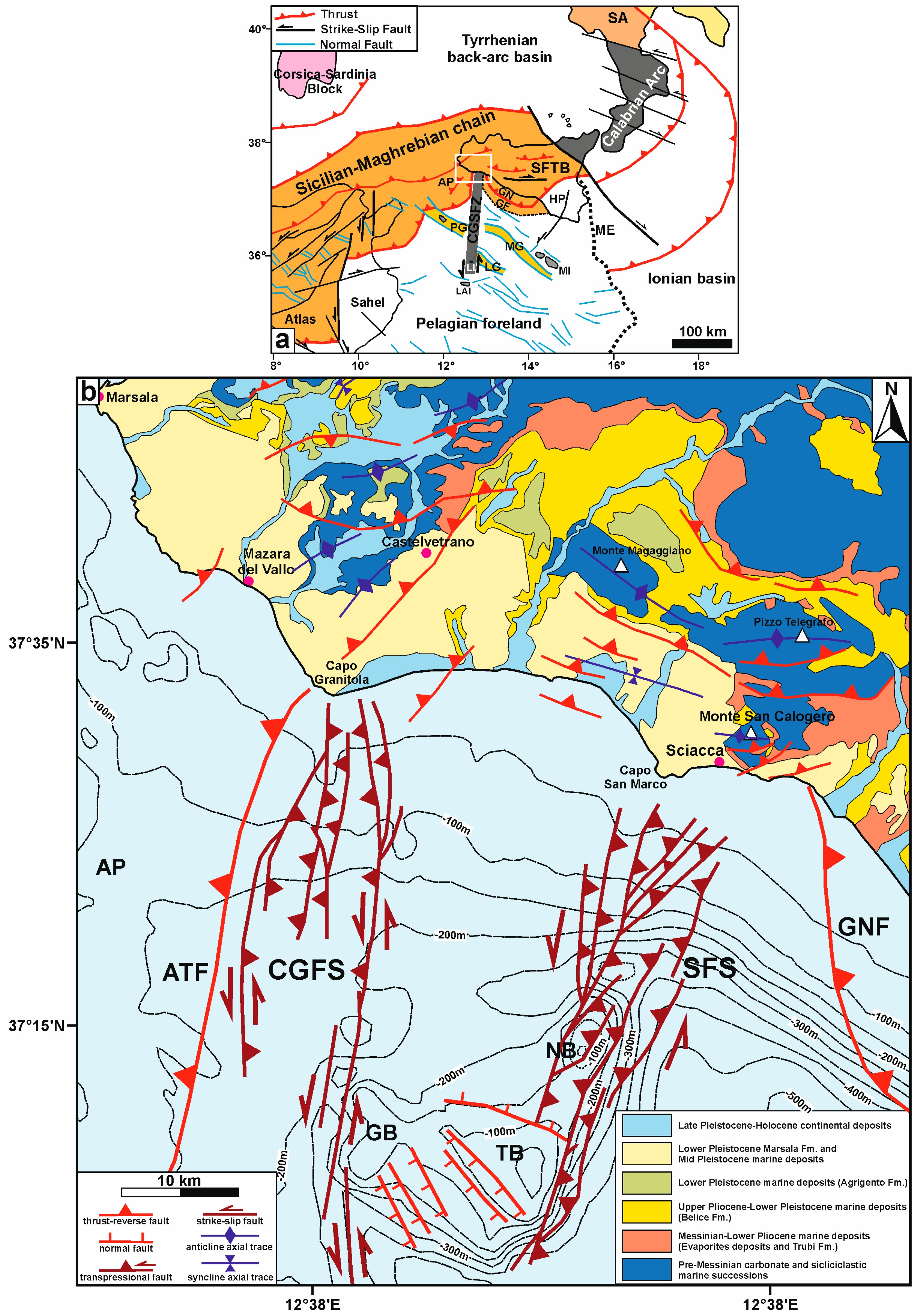
2. Geological Setting
2.1. Onshore Sciacca Area
2.2. Sciacca Geothermal Field
2.3. Offshore Sciacca Area
2.4. Gas Presence and Related Features in the Capo Granitola–Sciacca Offshore
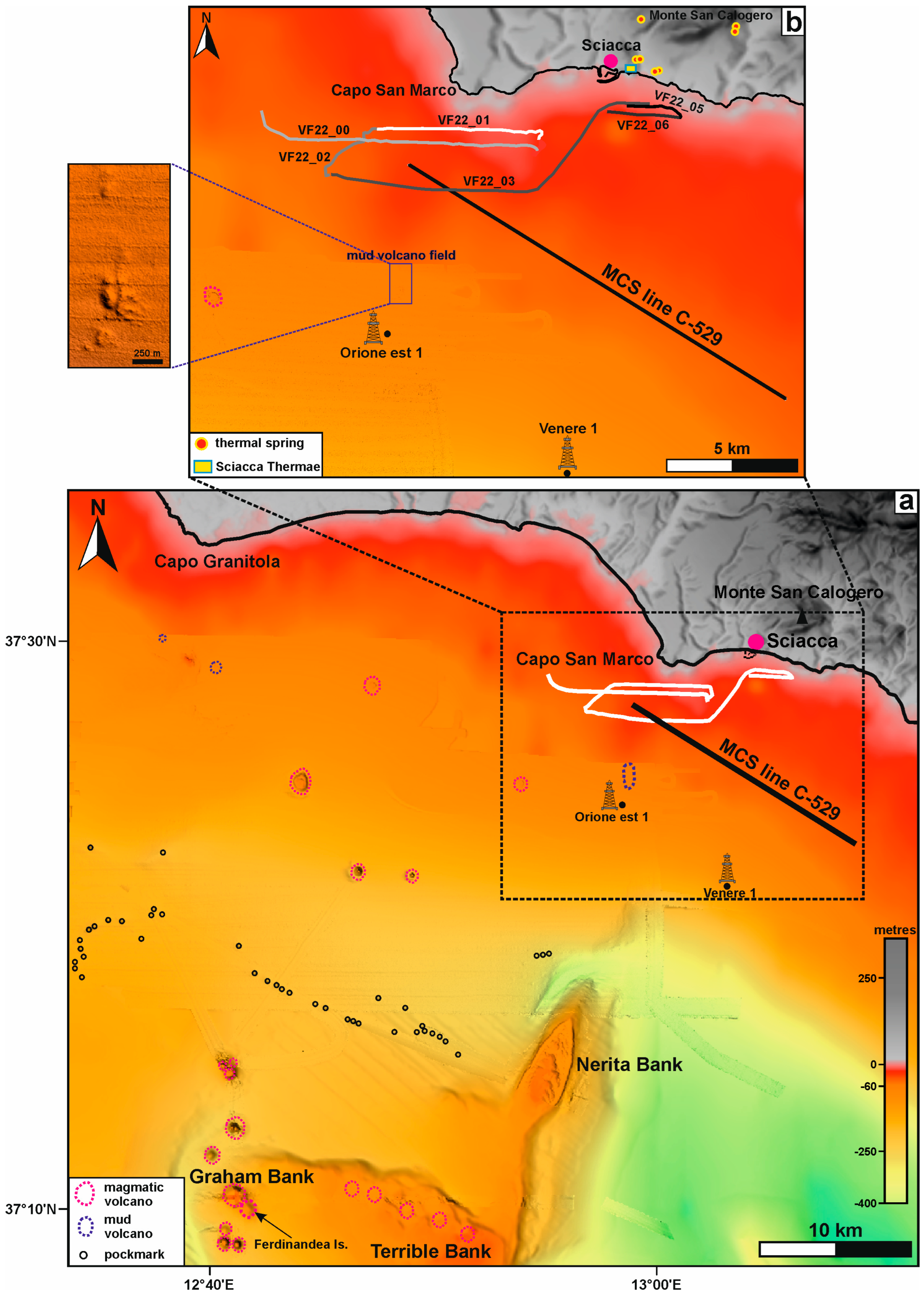
3. Materials and Methods
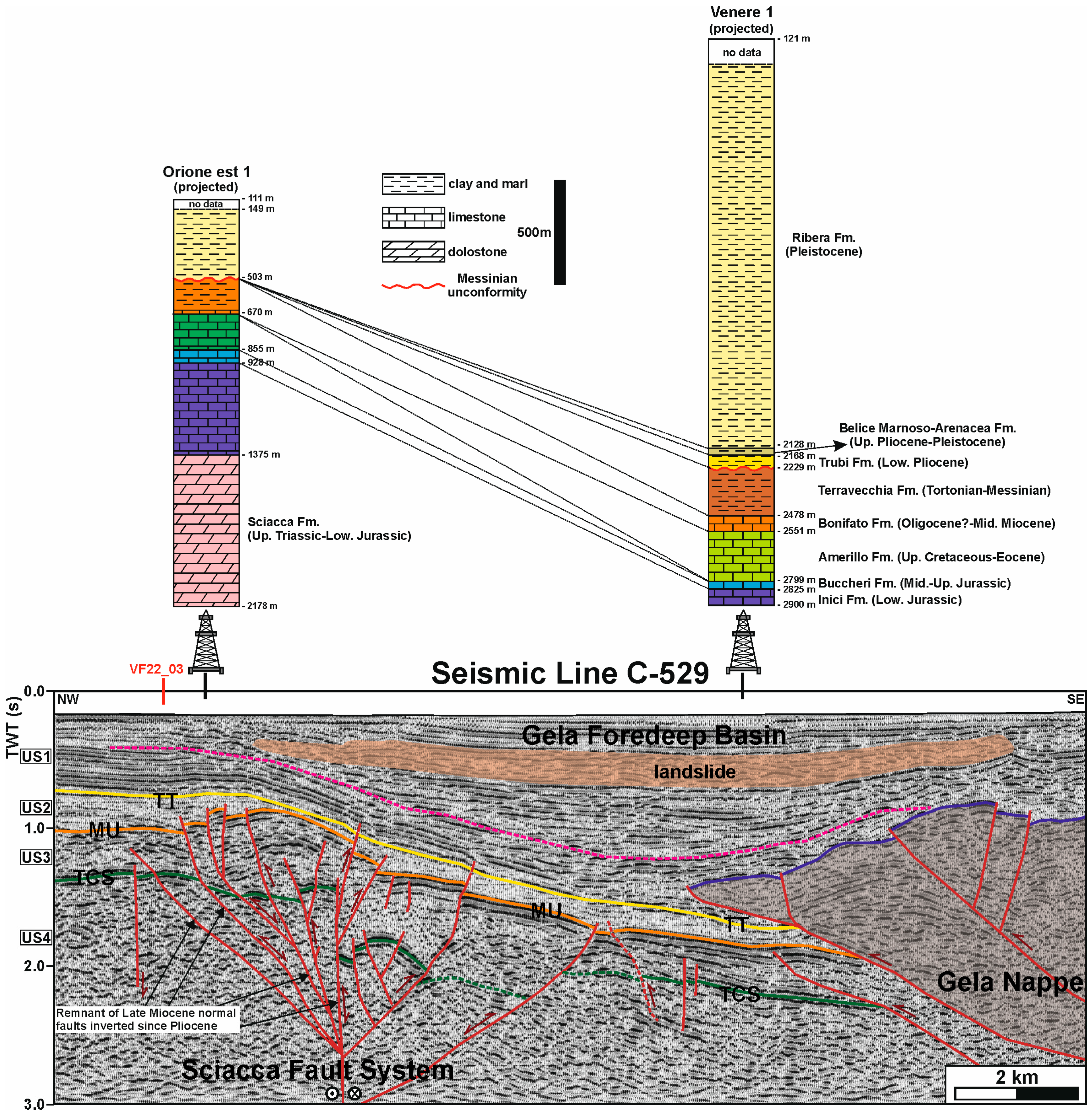
4. Results of the Seismic Data Interpretation
4.1. MCS Line C-529
4.1.1. Seismic Stratigraphy
4.1.2. Tectonics
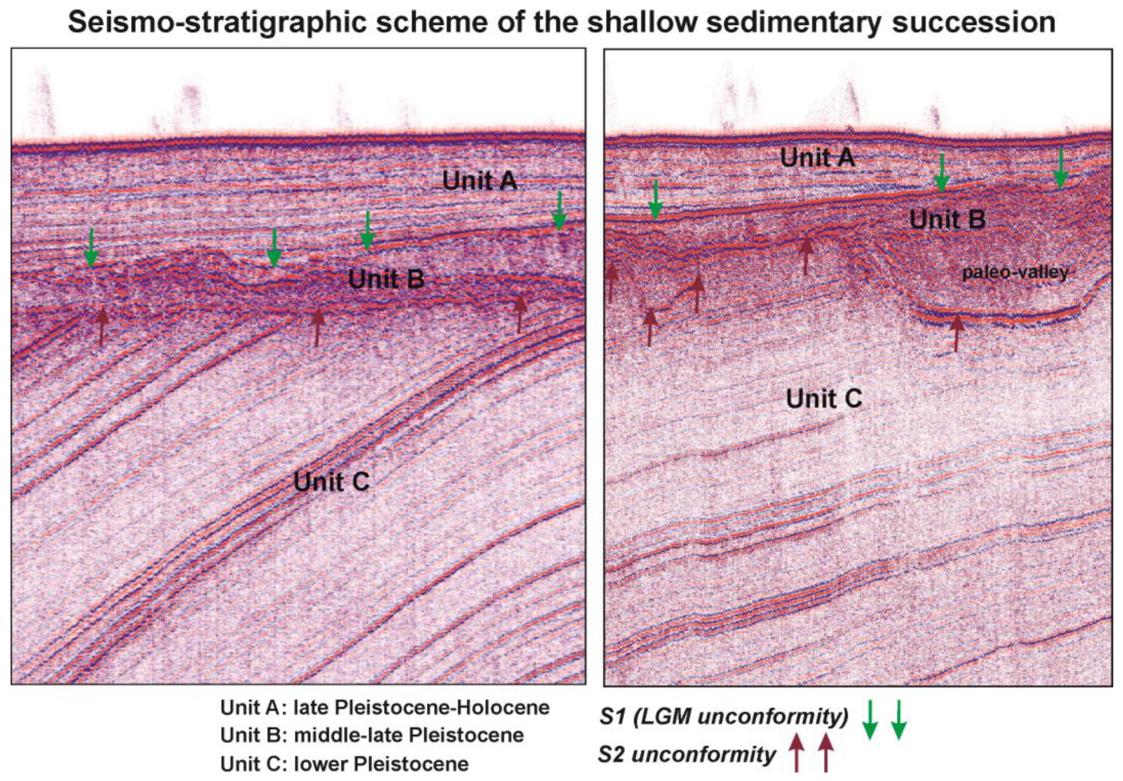
4.2. High-Resolution Seismic Lines
4.2.1. Seismic Stratigraphy
4.2.2. Fluid-Related Features
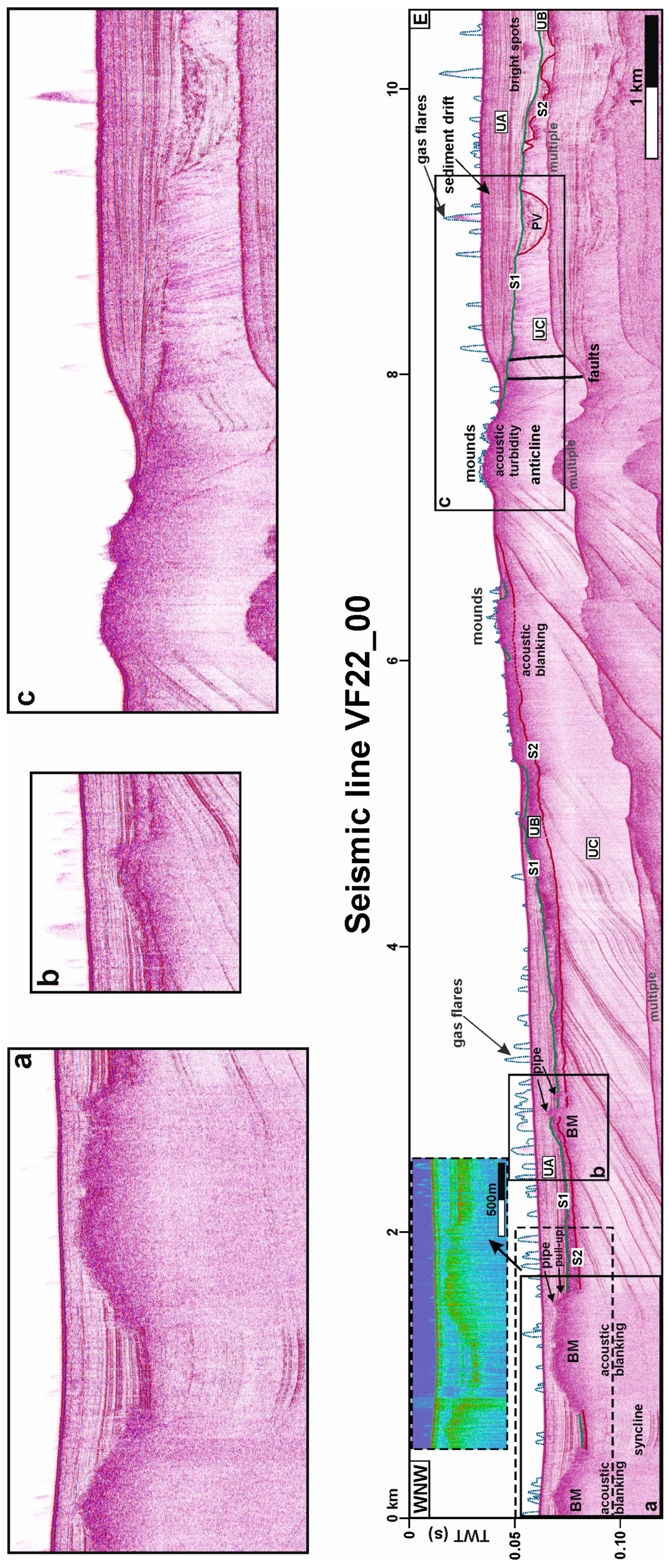
4.2.3. Line VF22_00
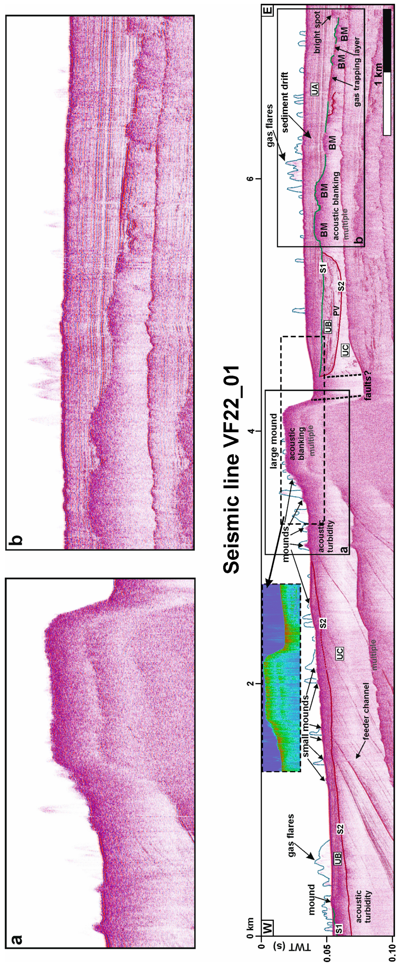
4.2.4. Line VF22_01
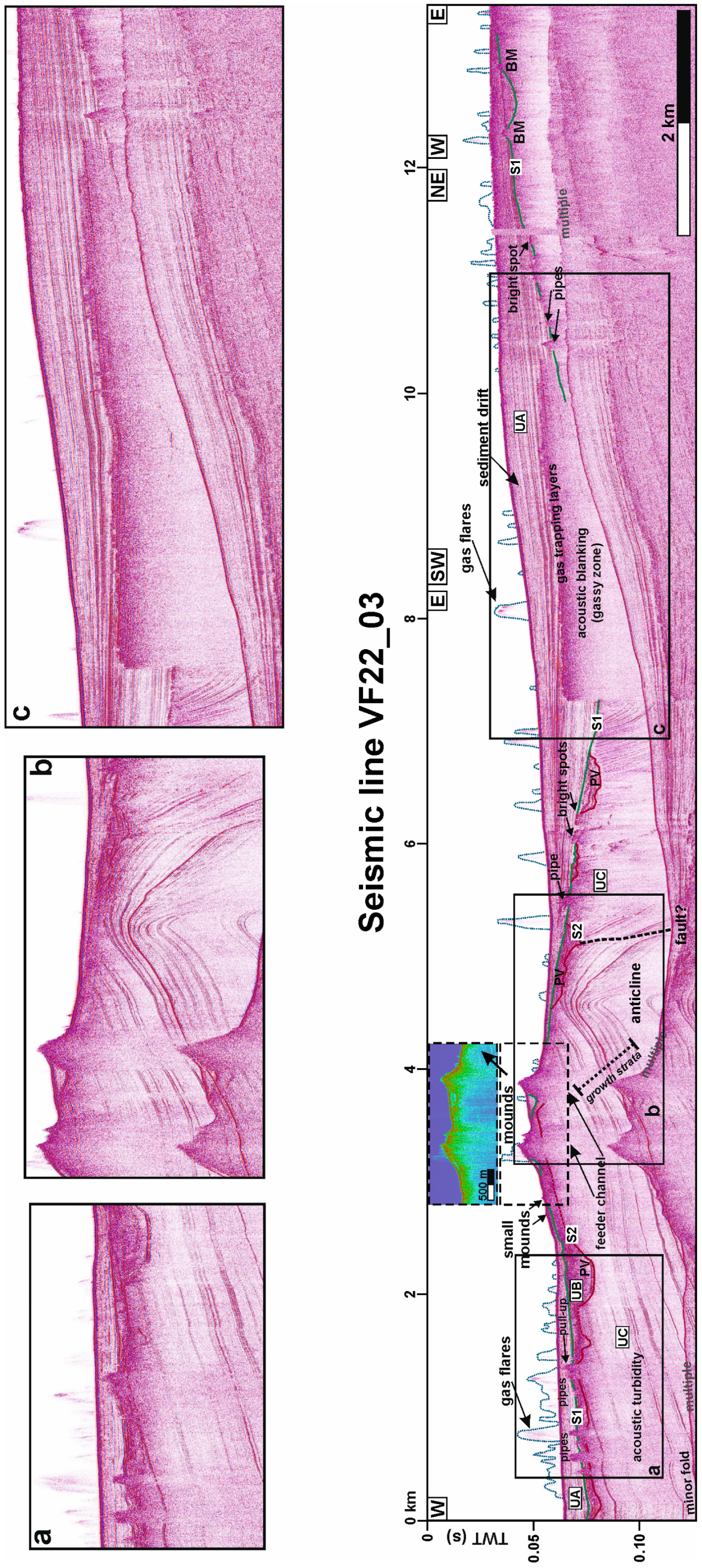
4.2.5. Line VF22_03
5. Discussion
6. Conclusions
Author Contributions
Funding
Institutional Review Board Statement
Informed Consent Statement
Data Availability Statement
Acknowledgments
Conflicts of Interest
References
- Aureli, A. Bacino Termale di Sciacca (Sicilia S.O.). In Caratteristiche Idrogeologiche e Vulnerabilità; CNR, Quaderni di Tecniche di Protezione Ambientale; Pitagora Editrice: Bologna, Italy, 1996; Volume 59, p. 168. [Google Scholar]
- Capaccioni, B.; Vaselli, O.; Tassi, F.; Santo, A.P.; Delgado Huertas, A. Hydrogeochemistry of the thermal waters from the Sciacca Geothermal Field (Sicily, southern Italy). J. Hydrol. 2011, 396, 292–301. [Google Scholar] [CrossRef]
- Ogniben, L. Schema introduttivo alla geologia del confine calabro-lucano. Mem. Soc. Geol. It. 1969, 8, 453–763. [Google Scholar]
- Argnani, A.; Cornini, S.; Torelli, L.; Zitellini, N. Neogene-Quaternary foredeep system in the Strait of Sicily. Mem. Soc. Geol. It. 1986, 36, 123–130. [Google Scholar]
- Argnani, A. The Strait of Sicily rift zone: Foreland deformation related to the evolution of a back-arc basin. J. Geodyn. 1990, 12, 311–331. [Google Scholar] [CrossRef]
- Civile, D.; Lodolo, E.; Accaino, F.; Geletti, R.; Schiattarella, M.; Giustiniani, M.; Fedorik, J.; Zecchin, M.; Zampa, L. Capo Granitola-Sciacca Fault Zone (Sicilian Channel, Central Mediterranean): Structure vs magmatism. Mar. Pet. Geol. 2018, 96, 627–644. [Google Scholar] [CrossRef]
- Civile, D.; Brancolini, G.; Lodolo, E.; Forlin, E.; Accaino, F.; Zecchin, M.; Brancatelli, G. Morphostructural setting and tectonic evolution of the central part of the Sicilian Channel (central Mediterranean). Lithosphere 2021, 2021, 7866771. [Google Scholar] [CrossRef]
- Ferranti, L.; Pepe, F.; Barreca, G.; Meccariello, M.; Monaco, C. Multi-temporal tectonic evolution of Capo Granitola and Sciacca foreland transcurrent faults (Sicily Channel). Tectonophysics 2019, 765, 187–204. [Google Scholar] [CrossRef]
- Montanari, D.; Minissale, A.; Doveri, M.; Gola, G.; Trumpy, E.; Santilano, A.; Manzella, A. Geothermal resources within carbonate reservoirs in western Sicily (italy): A review. Earth-Sci. Rev. 2017, 169, 180–201. [Google Scholar] [CrossRef]
- Caracausi, A.; Favara, R.; Italiano, F.; Nuccio, P.M.; Paonita, A.; Rizzo, A. Active geodynamics of the central Mediterranean sea: Heat and helium evidences for a transtensional zone connecting the Sicily Channel to the southern Tyrrhenian Sea. Geophys. Res. Lett. 2005, 32, L04312. [Google Scholar] [CrossRef]
- Donato, A.; Tassi, F.; Pecoraino, G.; Manzella, A.; Vaselli, O.; Candela Gagliano, E.; Santilano, A.; La Pica, L.; Scaletta, C.; Capecchiacci, F. Geochemical investigations of the geothermal systems from the Island of Sicily (southern Italy). Geothermics 2021, 95, 102120. [Google Scholar] [CrossRef]
- Ferrante, G.M.; Accaino, F.; Civile, D.; Lodolo, E.; Volpi, V.; Romeo, R.; Accettella, D. Deep and shallow gas occurrence in the NW Sicilian Channel and related features. Mar. Pet. Geol. 2022, 139, 105575. [Google Scholar] [CrossRef]
- Volpi, V.; Civile, D.; Lodolo, E.; Romeo, R.; Accettella, D.; Accaino, F.; Ferrante, G.M. Seabed and shallow morphological setting of the western Sicilian Channel. Bull. Geophys. Oceanogr. 2022, 63, 357–376. [Google Scholar] [CrossRef]
- Sibson, R.H. Structural permeability of fluid driven fault-fracture meshes. J. Struct. Geol. 1996, 18, 1031–1042. [Google Scholar] [CrossRef]
- Curewitz, D.; Karson, J.A. Structural settings of hydrothermal outflow: Fracture permeability maintained by fault propagation and interaction. J. Volcanol. Geotherm. Res. 1997, 79, 149–168. [Google Scholar] [CrossRef]
- Dewey, J.F.; Helman, M.L.; Knott, S.D.; Turco, E.; Hutton, D.H.W. Kinematics of the western Mediterranean. Geol. Soc. Spec. Pub. 1989, 45, 265–283. [Google Scholar] [CrossRef]
- Roure, F.; Howell, D.G.; Moretti, I.; Müller, C. Neogene subduction complex of Sicily. J. Struct. Geol. 1990, 12, 259–266. [Google Scholar] [CrossRef]
- Gueguen, E.; Doglioni, C.; Fernandez, M. On the post-25 Ma geodynamic evolution of the western Mediterranean. Tectonophysics 1998, 298, 259–269. [Google Scholar] [CrossRef]
- Faccenna, C.; Becker, T.W.; Pio Lucente, F.; Jolivet, L.; Rossetti, F. History of subduction and back-arc extension in the Central Mediterranean. Geophys J. Int. 2001, 145, 809–820. [Google Scholar] [CrossRef] [Green Version]
- Carminati, E.; Lustrino, M.; Doglioni, C. Geodynamic evolution of the central and western Mediterranean: Tectonics vs. igneous petrology constraints. Tectonophysics 2012, 579, 173–192. [Google Scholar] [CrossRef]
- Ferranti, L.; Burrato, P.; Selchi, D.; Andreucci, S.; Pepe, F.; Pascucci, V. Late Quaternary coastal uplift of southwestern Sicily, central Mediterranean sea. Quat. Sci. Rev. 2021, 255, 106812. [Google Scholar] [CrossRef]
- Barreca, G.; Bruno, V.; Cocorullo, C.; Cultrera, F.; Ferranti, L.; Guglielmino, F.; Guzzetta, L.; Mattia, M.; Monaco, C.; Pepe, F. Geodetic and geological evidence of active tectonics in south-western Sicily (Italy). J. Geodyn. 2014, 82, 138–149. [Google Scholar] [CrossRef] [Green Version]
- Di Stefano, P.; Vitale, F. Carta Geologica dei Monti Sicani Occidentali, Scala 1:50.000; Univeristà degli Studi di Palermo, Dipartimento di Geologia e Geodesia, Stampa Pezzino: Palermo, Italy, 1993. [Google Scholar]
- Ruggieri, G.; Unti, A.; Unti, M.; Moroni, M.A. La calcarenite di Marsala (Pleistocene Inferiore) e i terreni contermini. Boll. Soc. Geol. 1975, 94, 1623–1655. [Google Scholar]
- Di Maggio, C.; Agate, M.; Contino, A.; Basilone, L.; Catalano, R. Unconformity bounded stratigraphic units of Quaternary deposits mapped for the CARG Project in northern and western Sicily. Alp. Mediterr. Quat. 2009, 22, 345–364. [Google Scholar]
- Alaimo, R.; Tonani, F. Il Bacino Termale di Sciacca—Nota III, Geotermometria delle Acque Termali e Modello di Miscuglio per le Acque Emergenti; Risorse Termali Della Sicilia e Isole Minori: Palermo, Italy, 1984; pp. 3–18. [Google Scholar]
- Gemmellaro, C. Sopra la fisionomia delle montagne di Sicilia, cenno geologico. Atti Acc. Gioenia Sci. 1831, 5, 73. [Google Scholar]
- Gemmellaro, C. Relazione dei fenomeni del nuovo vulcano sorto dal mare fra la costa di Sicilia e l’isola di Pantelleria nel mese di luglio 1831. Atti Acc. Gioenia Sci. 1833, 8, 271–298. [Google Scholar]
- Hoffmann, F. Observations faites pendant un voyage en Sicile. Bull. Soc. Geol. De France 1833, 3, 70. [Google Scholar]
- Alaimo, R.; Carapezza, M.; Dongarrà, G.; Hauser, S. Geochimica delle sorgenti termali siciliane. Rend. Soc. Mineral. Petrol. 1978, 34, 577–590. [Google Scholar]
- Favara, R.; Grassa, F.; Inguaggiato, S.; Valenza, M. Hydrogeochemistry and stable isotopes of thermal springs: Earthquake-related chemical changes along Belice Fault (Western Sicily). Appl. Geochem. 2001, 16, 1–17. [Google Scholar] [CrossRef]
- Antonelli, M.; Franciosi, R.; Pezzi, G.; Querci, A.; Ronco, G.P.; Vezzani, F. Paleogeographic evolution and structural setting of the northern side of the Sicily Channel. Mem. Soc. Geol. 1988, 41, 141–157. [Google Scholar]
- Ghisetti, F.C.; Gorman, A.R.; Grasso, M.; Vezzani, L. Imprint of foreland structure on the deformation of a thrust sheet: The Plio-Pleistocene Gela Nappe (southern Sicily, Italy). Tectonics 2009, 28, TC4015. [Google Scholar] [CrossRef] [Green Version]
- Calò, M.; Parisi, L. Evidences of a lithospheric fault zone in the Sicily Channel continental rift (southern Italy) from instrumental seismicity data. Geophys. J. Int. 2014, 199, 219–225. [Google Scholar] [CrossRef] [Green Version]
- Fedorik, J.; Toscani, G.; Lodolo, E.; Civile, D.; Bonini, L.; Seno, S. Structural analysis and Miocene-to-present tectonic evolution of a lithospheric-scale, transcurrent lineament: The Sciacca Fault (Sicilian Channel, Central Mediterranean Sea). Tectonophysics 2018, 722, 342–355. [Google Scholar] [CrossRef]
- Palano, M.; Ursino, A.; Spampinato, S.; Sparacino, F.; Polonia, A.; Gasperini, L. Crustal deformation, active tectonics and seismic potential in the Sicily Channel (Central Mediterranean), along the Nubia-Eurasia plate boundary. Sci. Rep. 2020, 10, 21238. [Google Scholar] [CrossRef]
- Argnani, A.; Cornini, S.; Torelli, L.; Zitellini, N. Diachronous foredeep-system in the neogene-quaternary of the Strait of Sicily. Mem. Soc. Geol. It. 1987, 38, 407–417. [Google Scholar]
- Argnani, A. Neogene tectonics of the Strait of Sicily. In Geological Development of the Sicilian-Tunisian Platform; Max, M.D., Colantoni, P., Eds.; UNESCO Report in Marine Science; University of Urbino: Urbino, Italy, 1993; Volume 58, pp. 55–60. [Google Scholar]
- Argnani, A. Neogene basins in the Strait of Sicily (Central Mediterranean): Tectonic settings and geodynamic implications. In Recent Evolution and Seismicity of the Mediterranean Region; Boschi, E., Mantovani, E., Morelli, A., Eds.; Kluwer Academic Publication: Dordrecht, The Netherlands, 1993; pp. 173–187. [Google Scholar] [CrossRef]
- Grasso, M. The Apenninic-Maghrebian orogen in southern Italy, Sicily and adjacent areas. In Anatomy of an Orogen: The Apennines and Adjacent Mediterranean Basins; Vai, G.B., Martini, I.P., Eds.; Kluwer Academic Publishers: Norwell, MA, USA, 2001; pp. 255–286. [Google Scholar] [CrossRef]
- Lentini, F.; Carbone, S.; Guarnieri, P. Collisional and postcollisional tectonics of the Apenninic-Maghrebian Orogen (Southern Italy). In Post-Collisional Tectonics and Magmatism in the Eastern Mediterranean Region; Dilek, Y., Pavlides, S., Eds.; Geological Society of America Special Paper; The Geological Society of America: Boulder, CO, USA, 2006; Volume 409, pp. 57–81. [Google Scholar] [CrossRef]
- Catalano, R.; Franchino, A.; Merlini, S.; Sulli, A. A crustal section from the Eastern Algerian basin to the Ionian ocean (Central Mediterranean). Mem. Soc. Geol. It. 2000, 55, 71–85. [Google Scholar]
- Civile, D.; Lodolo, E.; Alp, H.; Ben-Avraham, Z.; Cova, A.; Baradello, L.; Accettella, D.; Burca, M.; Centonze, J. Seismic stratigraphy and structural setting of the Adventure Plateau (Sicily Channel). Mar. Geophys. Res. 2014, 35, 37–53. [Google Scholar] [CrossRef]
- Catalano, R.; Infuso, S.; Sulli, A. The Pelagian Foreland and its northward Foredeep. Plio-Pleistocene structural evolution. In Geological Development of the Sicilian-Tunisian Platform; Max, M.D., Colantoni, P., Eds.; UNESCO Report in Marine Science; University of Urbino: Urbino, Italy, 1993; Volume 58, pp. 37–42. [Google Scholar]
- Lickorish, W.H.; Grasso, M.; Butler, R.W.H.; Argnani, A.; Maniscalco, R. Structural styles and regional tectonic setting of the “Gela Nappe” and frontal part of the Maghrebian thrust belt in Sicily. Tectonics 1999, 18, 655–668. [Google Scholar] [CrossRef]
- Butler, R.W.H.; Grasso, M.; La Manna, F. Origin and deformation of the neogene recent maghrebian foredeep at the Gela Nappe, SE Sicily. J. Geol. Soc. 1992, 149, 547–556. [Google Scholar] [CrossRef]
- Catalano, R.; Di Stefano, P.; Sulli, A.; Vitale, F.P. Paleogeography and structure of the Central Mediterranean: Sicily and its offshore area. Tectonophysics 1996, 260, 291–323. [Google Scholar] [CrossRef]
- Catalano, R.; Valenti, V.; Albanese, C.; Accaino, F.; Sulli, A.; Tinivella, U.; Gasparo Morticelli, M.; Zanolla, C.; Giustiniani, M. Sicily’s fold–thrust belt and slab roll-back: The SI.RI.PRO. seismic crustal transect. J. Geol. Soc. 2013, 170, 451–464. [Google Scholar] [CrossRef]
- Cavallaro, D.; Monaco, C.; Polonia, A.; Sulli, A.; Di Stefano, A. Evidence of positive tectonic inversion in the north-central sector of the Sicily Channel (Central Mediterranean). Nat. Hazards 2017, 86, S233–S251. [Google Scholar] [CrossRef] [Green Version]
- Coltelli, M.; Cavallaro, D.; D’Anna, G.; D’Alessandro, A.; Grassa, F.; Mangano, G.; Patanè, D.; Gresta, S. Exploring the submarine Graham Bank in the Sicily Channel. Ann. Geophys. 2016, 59, S0208. [Google Scholar] [CrossRef]
- Lodolo, E.; Civile, D.; Zecchin, M.; Zampa, L.S.; Accaino, F. A series of volcanic edifices discovered a few kilometers off the coast of SW Sicily. Mar. Geol. 2019, 416, 105999. [Google Scholar] [CrossRef]
- Lodolo, E.; Renzulli, A.; Cerrano, C.; Calcinai, B.; Civile, D.; Quarta, G.; Calcagnile, L. Unreveling past submarine eruptions by dating lapilli tuff-encrusting coralligenous (Actea Volcano, NW Sicilian Channel). Front. Earth Sci. 2021, 9, 664591. [Google Scholar] [CrossRef]
- Cavallaro, D.; Coltelli, M. The Graham volcanic field offshore southwestern Sicily (Italy) revealed by high-resolution seafloor mapping and ROV images. Front. Earth Sci. 2019, 7, 311. [Google Scholar] [CrossRef] [Green Version]
- Washington, H.S. The submarine eruption of 1831 and 1891 near Pantelleria. Am. J. Sci. 1909, 27, 131–150. [Google Scholar] [CrossRef]
- Colantoni, P.; Del Monte, M.; Gallignani, P.; Zarudzki, E.F.K. Il Banco Graham: Un vulcano recente del Canale di Sicilia. Giorn. Geol. 1975, 40, 141–162. [Google Scholar]
- Di Stefano, E.; Infuso, S.; Scarantino, S. Plio-Pleistocene sequence stratigraphy of south western offshore Sicily from well-logs and seismic sections in a high resolution calcareous plankton biostratigraphic framework. In Geological Development of the Sicilian-Tunisian Platform; Max, M.D., Colantoni, P., Eds.; UNESCO Report in Marine Science; University of Urbino: Urbino, Italy, 1993; Volume 58, pp. 105–110. [Google Scholar]
- Cohen, J.K.; Stockwell, J.W. CWP/SU: Seismic Un*x Release No. 42: An Open Source Software Package for Seismic Research and Processing; Center for Wave Phenomena, Colorado School of Mines: Golden, CO, USA, 2010. [Google Scholar]
- Meccariello, M. Tectonic evolution and current deformation of the NW Sicily Channel and the Lampedusa Plateau based on multi-resolution seismic profiles analysis. Ph.D. Thesis, Univeristy of Naples Federico II, Naples, Italy, 2017; p. 261. Available online: http://www.fedoa.unina.it/12119/ (accessed on 5 March 2018).
- Civile, D.; Lodolo, E.; Zecchin, M.; Ben-Avraham, Z.; Baradello, L.; Accettella, D.; Cova, A.; Caffau, M. The lost Adventure Archipelago (Sicilian Channel, Mediterranean Sea): Morpho-bathymetry and Late Quaternary palaeogeographic evolution. Glob. Planet. Change 2015, 125, 36–47. [Google Scholar] [CrossRef]
- Civile, D.; Lodolo, E.; Caffau, M.; Baradello, L.; Ben-Avraham, Z. Anatomy of a submerged archipelago in the Sicilian Channel (central Mediterranean Sea). Geol. Mag. 2016, 153, 160–178. [Google Scholar] [CrossRef]
- Lodolo, E.; Galassi, G.; Spada, G.; Zecchin, M.; Civile, D.; Bressoux, M. Post-LGM coastline evolution of the NW Sicilian Channel: Comparing high-resolution geophysical data with Glacial Isostatic Adjustment modeling. PLoS ONE 2020, 15, e0228087. [Google Scholar] [CrossRef]
- Siddall, M.; Rohling, E.J.; Almogi-Labin, A.; Hemleben, C.; Meischner, D.; Schmelzer, I.; Smeed, D.A. Sea-level fluctuations during the last glacial cycle. Nature 2003, 423, 853–858. [Google Scholar] [CrossRef]
- Clarke, P.U.; Dyke, A.S.; Shakum, J.D.; Carlson, A.E.; Clark, J.; Wohlfarth, B.; Mitrovica, J.X.; Hostetler, S.W.; McCabe, A.M. The last glacial maximum. Science 2009, 325, 710–714. [Google Scholar] [CrossRef] [PubMed] [Green Version]
- Kim, Y.-J.; Cheong, S.; Chun, J.-H.; Cukur, D.; Kim, A.-P.; Kim, J.-K.; Kim, B.-Y. Identification of shallow gas by seismic data and AVO processing: Example from the southwestern continental shelf of the Ulleung Basin, East Sea, Korea. Mar. Pet. Geol. 2020, 117, 104346. [Google Scholar] [CrossRef]
- Horozal, S.; Chae, S.; Kim, D.H.; Seo, J.M.; Lee, S.M.; Han, H.S.; Cukur, D.; King, G.-S. Seismic evidence of shallo gas in sediments on the southeastern continental shelf of Korea, east Sea (Japan Sea). Mar. Pet. Geol. 2021, 133, 105291. [Google Scholar] [CrossRef]
- Ma, G.; Zhan, L.; Lu, H.; Hou, G. Structures in shallow marine sediments associated with gas and fluid migration. J. Mar. Sci. Eng. 2021, 9, 396. [Google Scholar] [CrossRef]
- Judd, A.G.; Hovland, M. The evidence of shallow gas in marine sediments. Cont. Shelf Res. 1992, 12, 1081–1095. [Google Scholar] [CrossRef]
- Schroot, B.M.; Klaver, G.T.; Schüttenhelm, R.T.E. Surface and subsurface expressions of gas seepage to the seabed—Examples from the Southern North Sea. Mar. Pet. Geol. 2005, 22, 499–515. [Google Scholar] [CrossRef]
- Gay, A.; Lopez, M.; Berndt, C.; Séranne, M. Geological controls on focused fluid flow associated with seafloor seeps in the Lower Congo Basin. Mar. Geol. 2007, 244, 68–92. [Google Scholar] [CrossRef]
- Lee, M.W.; Dillon, W.P. Amplitude blanking related to the pore-fillingof gas hydrate in sediments. Mar. Geophys. Res. 2001, 22, 101–109. [Google Scholar] [CrossRef]
- Baltzer, A.; Tessier, B.; Nouzé, H.; Bates, R.; Moore, C.; Menier, D. Seistec seismic profile: A toll to differentiate gas signatures. Mar. Geophys. Res. 2005, 26, 235–245. [Google Scholar] [CrossRef]
- Davis, A.M. Shallow gas: An overview. Continent. Shelf Res. 1992, 12, 1077–1079. [Google Scholar] [CrossRef]
- Schroot, B.M.; Schüttenhelm, R.T.E. Shallow gas and gas seepage: Expressions on seismic and other acoustic data from the Netherlands North Sea. J. Geochem. Explor. 2003, 78, 305–309. [Google Scholar] [CrossRef]
- Judd, A.G.; Hovland, M. Seabed Fluid Flow: The Impact of Geology, Biology and the Marine Environment; Cambridge University Press: Cambridge, UK, 2007; p. 475. [Google Scholar] [CrossRef]
- Moss, J.L.; Cartwright, J. 3D seismic expression of km-scale fluid escape pipes from offshore Namibia. Basin Res. 2010, 22, 481–501. [Google Scholar] [CrossRef]
- Huuse, M.; Jackson, C.A.L.; Van Rensbergen, P.; Davies, R.J.; Flemings, P.B.; Dixon, R.J. Subsurface sediment remobilization and fluid flow in sedimentary basins: An overview. Basin Res. 2010, 22, 342–360. [Google Scholar] [CrossRef]
- Løseth, H.; Gading, M.; Wensaas, L. Hydrocarbon leakage interpreted on seismic data. Mar. Pet. Geol. 2009, 26, 1304–1319. [Google Scholar] [CrossRef]
- Løseth, H.; Wensaas, L.; Arntsen, B.; Hanken, N.-M.; Basire, C.; Graue, K. 1000 m long gas blow-out pipes. Mar. Pet. Geol. 2011, 28, 1047–1060. [Google Scholar] [CrossRef]
- Sheriff, R.; Geldart, L. Exploration Seismology, 2nd ed.; Cambridge University Press: Cambridge, UK, 1995; p. 416. [Google Scholar]
- Naudts, L.; Batist, M.D.; Greinert, J.; Artemov, Y. Geo- and hydro-acoustic manifestations of shallow gas and gas seeps in the Dnepr paleodelta, northwestern Black Sea. Lead. Edge 2009, 28, 1030–1040. [Google Scholar] [CrossRef] [Green Version]
- Mancuso, M.R.; Catalano, R. Evidenze sismostratigrafiche di fenomeni da espulsione di fluidi, superficiali e profondi, nell’offshore tra Sciacca e Agrigento (Sicilia meridionale). Mem. Descr. Carta Geol. d’It. 2020, 105, 97–102. [Google Scholar]
- Aloisi, G.; Bouloubassi, I.; Heijs, S.K.; Pancost, R.D.; Pierre, C.; Sinninghe Damsté, J.S.; Gottschal, J.C.; Forney, L.J.; Rouchy, J.-M. CH4-consuming microorganisms and the formation of carbonate crusts at cold seeps. Earth Planet. Sci. Lett. 2002, 203, 195–203. [Google Scholar] [CrossRef]
- Mazzini, A.; Ivanov, M.K.; Parnell, J.; Stadnitskaia, A.; Cronin, B.T.; Poludetkina, E.; Mazurenko, L.; van Weering, T.C.E. Methane-related authigenic carbonates from the Black Sea: Geochemical characterisation and relation to seeping fluids. Mar. Geol. 2004, 212, 153–181. [Google Scholar] [CrossRef]
- Holland, C.W.; Etiope, G.; Milkov, A.V.; Michelozzi, E.; Favali, P. Mud volcanoes discovered offshore Sicily. Mar. Geol. 2003, 199, 1–6. [Google Scholar] [CrossRef]
- Burgess, P.M.; Winefield, P.; Minzoni, M.; Elders, C. Methods for identification of isolated carbonate buildups of isolated carbonate reflection data. AAPG Bull. 2013, 97, 1071–1098. [Google Scholar] [CrossRef]
- Donda, F.; Civile, D.; Forlin, E.; Volpi, V.; Zecchin, M.; Gordini, E.; Merson, B.; De Santis, L. The northernmost Adriatic Sea: A potential location for CO2 geological storage? Mar. Pet. Geol. 2013, 42, 148–159. [Google Scholar] [CrossRef]
- Slonka, L.; Krzywiec, P. Seismic characteristics and development of the Upper Jurassic carbonate buildups from the Miechów Trough (Southern Poland). Geosciences 2020, 10, 239. [Google Scholar] [CrossRef]

Disclaimer/Publisher’s Note: The statements, opinions and data contained in all publications are solely those of the individual author(s) and contributor(s) and not of MDPI and/or the editor(s). MDPI and/or the editor(s) disclaim responsibility for any injury to people or property resulting from any ideas, methods, instructions or products referred to in the content. |
© 2023 by the authors. Licensee MDPI, Basel, Switzerland. This article is an open access article distributed under the terms and conditions of the Creative Commons Attribution (CC BY) license (https://creativecommons.org/licenses/by/4.0/).
Share and Cite
Civile, D.; Baradello, L.; Accaino, F.; Zecchin, M.; Lodolo, E.; Ferrante, G.M.; Markezic, N.; Volpi, V.; Burca, M. Fluid-Related Features in the Offshore Sector of the Sciacca Geothermal Field (SW Sicily): The Role of the Lithospheric Sciacca Fault System. Geosciences 2023, 13, 231. https://doi.org/10.3390/geosciences13080231
Civile D, Baradello L, Accaino F, Zecchin M, Lodolo E, Ferrante GM, Markezic N, Volpi V, Burca M. Fluid-Related Features in the Offshore Sector of the Sciacca Geothermal Field (SW Sicily): The Role of the Lithospheric Sciacca Fault System. Geosciences. 2023; 13(8):231. https://doi.org/10.3390/geosciences13080231
Chicago/Turabian StyleCivile, Dario, Luca Baradello, Flavio Accaino, Massimo Zecchin, Emanuele Lodolo, Giulia Matilde Ferrante, Nora Markezic, Valentina Volpi, and Mihai Burca. 2023. "Fluid-Related Features in the Offshore Sector of the Sciacca Geothermal Field (SW Sicily): The Role of the Lithospheric Sciacca Fault System" Geosciences 13, no. 8: 231. https://doi.org/10.3390/geosciences13080231