


The Response of the Rivers of NW Greece to Late Quaternary Neotectonics, as Interpreted from Detrital Petrology

1
Natural Resources Canada, Geological Survey of Canada (Atlantic), Bedford Institute of Oceanography, Dartmouth, NS B2Y 4A2, Canada
2
Department of Oceanography, Dalhousie University, Halifax, NS B3H 4R2, Canada
3
Department of Geology, Saint Mary’s University, Halifax, NS B3H 3C3, Canada
*
Author to whom correspondence should be addressed.
Geosciences 2022, 12(11), 392; https://doi.org/10.3390/geosciences12110392
Submission received: 1 September 2022
/
Revised: 14 October 2022
/
Accepted: 22 October 2022
/
Published: 25 October 2022
(This article belongs to the Special Issue Tectonic Geomorphology in Modern Orogenic Zones)
Abstract
:The modern drainage systems of the fold and thrust belt of the external Hellenide orogen of NW Greece are principally orogen-parallel. Late Quaternary changes in river courses have resulted from neotectonic deformation associated with the Katouna–Stamna fault and with footwall uplift in developing transverse grabens. This study assesses the impact of neotectonic deformation on river patterns and basin deposition. River sands show differences in modal abundance and varietal geochemistry of heavy minerals and fine sand lithic clasts, determined by scanning electron microscope, that allow identification of past river supply to raised fluvial terrace and beach deposits. In the past 200 ka, footwall uplift south of developing grabens at Lake Trichonis and the Amvrakikos Gulf promoted orogen-transverse flow, diverting the Arachthos-Louros rivers to the west, causing reversal of drainage to the north in the lower reach of the Acheloos River. A raised terrace gravel south of Preveza records the southwestward flow of a large paleo-Arachthos river, confirmed by sand petrology in beaches farther south on the Echinadon Sea coast. The use of varietal heavy minerals and lithic clasts is a rapid and powerful tool for tracking tectonically-induced changes in river patterns.
1. Introduction
The modern drainage systems of the Hellenides of NW Greece, in the regions of Epirus and Aitoloakarnania (Figure 1), are in part orogen-parallel, draining to the SSE, and in part orogen-transverse, draining westward to the Ionian Sea. Although originally controlled by the Paleogene to Miocene thrusting and folding, significant changes may have occurred as a result of Quaternary basin formation related to final collision with the Adria microplate and the roll-back of the South Aegean Arc subduction system [1]. The roll-back led to the opening of the Gulf of Corinth and smaller E–W trending grabens in Aitoloakarnania [2], linked by the Katouna–Stamna fault [3] (Figure 1). In places in both Epirus and Aitoloakarnania, neotectonic orogen-transverse faulting appears to have diverted rivers to the west, transverse to the orogen [4,5]. Nevertheless, the scope and timing of changes in river courses remain uncertain.
Heavy minerals have been widely used to investigate changes in river paths and more generally to track sediment provenance, and this approach is the focus of this study. Classical optical methods of heavy mineral investigation [6] are labour-intensive and provide only general identification of mineral classes. Using scanning electron microscope (SEM) with energy dispersive spectroscopy (EDS) or electron microprobe techniques provides additional information on mineral chemistry [7,8], allowing the asessment of abundance of varieties of the same mineral, which reduces the bias created by grain size and sorting on modal abundance [9,10].
The first goal of this study was to establish whether the different rivers of NW Greece had sufficiently different heavy mineral assemblages to track their former distribution and contributions to raised terraces and beaches. The second goal was to formulate a general synthesis of the relationship between tectonic evolution and river development in northwestern Greece, with the intent of understanding the changes in sediment provenance in the depositional basins. The methodology presented in this paper and the observations on the influence of active faulting on orogen-parallel river systems should be applicable to studies of river evolution elsewhere.

2. Geological Setting
2.1. General Geological History
The study area in Aitoloakarnanía and Epirus is located in the fold and thrust belt of the external Hellenide orogen, in a series of NNW–SSE trending tectonic units of the Pindos, Gavrovo, Ionian and Pre-Apulian (or Paxos) isopic zones [13] (Figure 2). Mesozoic–Paleogene sediments, principally limestones with lesser cherts and shales, accumulated over ocean crusts in the Pindos ocean. On the outer margin of the Apulian platform of the Adria microplate, the platform limestones of the Gavrovo outer high was separated from the Apulian margin sensu stricto (the Pre-Apulian zone) by the deeper waters of the Ionian basin, where limestones and lesser shales overlie Triassic salt. As deformation of the external Hellenides migrated westward in the Paleogene, detrital siliciclastic sediment from the internal Hellenide orogen (including thrust sheets of Pindos zone ophiolites) accumulated in flysch basins of Paleocene–Oligocene age in the Pindos zone and of latest Eocene to Miocene age in the Gavrovo and Ionian zones [14]. The sources of this detritus are known from optical studies of heavy minerals in sandstones [6] and limited studies of pebble lithologies [15].
The South Aegean Arc subduction system experienced major roll-back throughout the Neogene [21], leading to back-arc extension in the Aegean Sea and eventual collision with the African plate south of Crete and with the Adria microplate in the Ionian Sea (Figure 1, inset). Neotectonic activity is inferred from geomorphological observations of faults, active seismicity and GPS geodetic measurement [3,22,23]. The roll-back led to the opening of the Gulfs of Corinth and Patras, and related E–W trending graben, including the Lake Trichonis graben [24] and Amvrakikos Gulf [2] that are linked to the Gulf of Patras by the Katouna–Stamna sinistral N–S fault system [3] (Figure 2). As compression between the Hellenides and Adria, including Apulia, diminished, the subduction system terminated westward in a newly developed transform, the Kefallinia Fault (Figure 1). In northern Epirus, E–W sinistral strike–slip fault zones developed in the Quaternary [23] (Figure 2).
2.2. The Evolution of River Systems
Greece hosts the most rapidly extending area of continental crust in the world, and this active tectonism has attracted many studies of the relationship between tectonics and river patterns. The active rifting and footwall uplift in the Gulf of Corinth has been the focus of much work on the influence of listric and transfer faulting on geomorphic evolution [25,26,27,28]. The earlier Plio–Pleistocene record of drainage is interpreted from well-preserved uplifted deposits [2]. In Epirus, the relationship between different orders of the drainage network and the presence of late Pleistocene faults has been analysed to demonstrate an outboard zone influence by active E–W faults and an inboard zone where NNW-trending thrusts are more influential [5]. These results were summarized in a conceptual model from Miocene to present.
The largest river in our study region is the Acheloos River, with a drainage basin of 4500 km2 [29] in the Ionian, Gavrovo and Pindos zones (Figure 2). In northern Epirus the Gavrovo zone is overthrust, so that the Arachthos River (2200 km2) also drains the Ionian and Pindos zones, whereas the Louros River (960 km2) is entirely within the Ionian zone. The Louros is in the outboard tectono-geomorphic zone of [5], and the Arachthos in the inboard zone. All three rivers today drain southward along depressions in the fold and thrust belt, but in places have broken through thrusted anticlines to flow westward, in the case of the Arachthos and Louros rivers through the Amvrakikos Gulf [4]. The Evinos River basin lies mostly in the Pindos zone and the river has a more transverse course.
The evolving marine basins adjacent to the Ionian Sea provide a means of constraining the timing of particular river courses. In these basins, stacked coastal progradation units recorded in seismic profiles formed at times of sea-level lowstands controlled by glacio-eustasy [18,30,31]. These lowstands are named for the corresponding marine isotope stages (MIS), with MIS 2 corresponding to the last glacial maximum and MIS 6 to the penultimate glaciation (Figure 2, inset). The Acheloos River first supplied sediment to the outer Gulf of Patras at about 1 Ma [32]. The delta prograded westward, indicating that the mouth was located south of Etoliko, perhaps controlled by flow through the Klissoura gorge (Figure 2). Only above horizon A of [32], dating from MIS 6 or 8, did the delta prograde to the southwest, from near its present mouth, in response to footwall uplift in the Trichonis graben [33]. Old fluvial terrace deposits are present along the Katouna–Stamna fault zone and on the Akarnania horst immediately south of Amvrakikos Gulf.
2.3. Previous Heavy Mineral Studies
Classical optical identification of heavy mineral assemblages was reported from the sands of the major rivers of Greece, including the Louros, Arachthos, Acheloos and Mornos [34]. Optical mineral identification was also used in extensive studies of the Cenozoic flysch deposits of northwestern Greece [6,35,36]). Some analyses of minerals in Pindos flysch samples by SEM-EDS have also been reported [37,38].
Heavy mineral composition of the flysch sandstones of the study area was presented in detail by Faupl et al. [6], who interpreted a principal source from igneous and metamorphic rocks of the internal Hellenides. Igneous rocks there include Jurassic ophiolites and Carboniferous granitoid plutons [39], and the metamorphic rocks include metaophiolites and other lithologies exhumed from the subduction channel [21].
3. Materials and Methods
Samples were collected from rivers, beaches and raised river terraces (Supplementary Table S1; Figure 2). Multiple samples were collected from the major rivers to ensure there was no significant local variability. Most of the rivers have been dammed, with construction starting in the 1950s. As a result, the reaches of most rivers downstream from dams have been largely flushed of sandy sediment, and samples were obtained from the old braid-plain, inferred to predate damming. Samples from meandering rivers on delta plains were taken from overbank settings in the lee of tree trunks, where suspended sediment was deposited in floods. Much of this sediment is thought to be reworked from fluvial deposits predating dam construction.
The beach samples at Monolithos, Aktion and Pogonia (Figure 2) represent three alluvium-filled potential outlets of the late Pleistocene Louros and/or Arachthos rivers and were collected to resolve former courses of these rivers. The pocket beach at Mytikas has no significant drainage from land, but it may have received sand transported landward during the Holocene transgression [19]. Raised terrace deposits that were sampled preserve a direct record of the former courses of rivers.
Samples were sieved to remove gravel and fines <63 μm. The bulk sand sample (63–2000 μm) was used for bulk chemical analysis and to make polished thin sections. Selected thin sections were point counted (600 points) using a petrographic microscope with a mechanical stage. Heavy minerals were separated from the 63–180 μm fraction using an aqueous solution of sodium polytungstate prepared to a specific gravity of 2.9. Polished thin sections were made of the heavy mineral fraction with an energy-dispersive spectroscopy (EDS) system, detailed by [40]. Analytical spot size is ~10 μm. Element detection limit for elements heavier than Na is ~0.1%. Analytical precision and accuracy has been estimated as having an overall relative standard deviation of 8% [41]. Although analyses are thus semiquantitative [42], they are sufficient to identify varietal minerals. Analyses with >2% non-stoichiometric elements (generally due to inclusions) or analytical totals >3% from stoichiometry were discarded.
Heavy minerals were identified from their chemical composition and textures recorded in backscattered-electron (BSE) images, using chemical criteria summarized by [40]. Modal abundance of minerals in the 63–180 μm heavy fraction is based on EDS analyses of both discrete grains and component minerals of lithic clasts within the same size fraction, with at least 280–670 analyses counted in each sample, except for sample 24, which had a low yield of heavy minerals. Analyses of selected minerals with lower specific gravity, which were either not completely separated or formed part of lithic clasts, were also counted. Comparison is made with heavy minerals reported by [6], who separated minerals with specific gravity >2.96 and size range 63–400 μm. Compositions of minerals that show a substantial range in their chemistry were used for varietal mineral analysis, using standard mineralogical plots from the literature for pyroxene, garnet, and chromite plus spinel [8]. Plots were also prepared for minerals such as amphibole, chlorite and tourmaline, but are not illustrated because of small numbers of analyses and thus uncertain interpretation.
Lithic clasts in the 63–180 μm heavy mineral separates have also been identified. Such clasts are classified into five categories: igneous, sedimentary, metamorphic, hydrothermal and ophiolitic (ultramafic), based on mineralogy and mineral texture in BSE images.
4. Results
4.1. Field Geology of the Terrace Deposits
The Ag. Nikolaos deposit is exposed in a large gravel pit (Figure 3a) at 80–90 m above sea level (asl). It consists principally of 2–3 cm sorted pebble conglomerate in sets with irregular channeled contacts, and in places with some pebbly medium- to coarse-grained sandstone. Cross-bedded sets and scour-and-fill structures suggest generalized flow to the SW. The top 5 m of the succession has been pedogenically reddened. The sample was taken from a sandy bed below the altered unit.
The Loutraki and Stanos localities consist of bedded pebbly sandstone and both channelled and flat-lying conglomerates in road-cut outcrops that are less than 3 m high. The entire sections at both localities are pedogenically reddened and have severe alteration of ferromagnesian minerals and iron oxides and precipitation of limonite. The Loutraki outcrop at 90 m asl has tabular conglomerate bodies with dipping prograded strata at their margins, suggesting an origin in gravel bars that prograded in a generally northern direction (Figure 3b). Well-developed imbrication of pebbles dipping to the south (Figure 3b) confirms this paleocurrent interpretation. The Stanos outcrop is smaller and less informative, but also has imbricated sets of pebbles dipping to the S or SE (Figure 3c).
4.2. Bulk Petrology
Total lithic clasts generally exceed the abundance of quartz grains in medium- to coarse-grained sands (Table 1). Lithic clasts vary with grain size, but are principally of carbonate and siliciclastic sedimentary rocks. All the sands studied classify petrologically as litharenite or sublitharenite [43].
4.3. Modal Abundance of Heavy Minerals
Modal abundance of minerals in the 63–180 μm heavy fraction are presented in Table 2 and Table 3. The set of resistant heavy-minerals illustrated in pie diagrams in Figure 4 are used to compare beaches and weathered terrace deposits with river sands, which contain variable proportions of ferromagnesian minerals that are readily comminuted and altered.
The Evinos River sample is dominated by garnet, epidote, chromite and spinel, with lesser apatite and rutile. A similar mineral assemblage is found in the Acheloos River samples, but tourmaline, rutile, ilmenite and zircon are more abundant than in the Evinos. The Louros River samples also have an assemblage similar to the Evinos, except that tourmaline is less abundant and small amounts of staurolite occur. Magnetite is particularly abundant in the upper Louros River sample. The Arachthos River samples are remarkable for the dominance of olivine, ortho- and clino-pyroxene, chromite and spinel, and consequently a lower percentage of most other heavy minerals compared to the other rivers.
The Aktion beach sample has a distinctly different heavy mineral assemblage compared to the three other analysed beach samples. Orthopyroxene is dominant, with lesser chromite, spinel, epidote, fluorite, rutile and clinopyroxene. The other beach samples have dominant chromite and spinel, with common epidote (high at Mytikas, low at Monolithos) and garnet, and some orthopyroxene (lowest at Mytikas), zircon and staurolite. Pogonia beach sand has common ilmenite and Mytikas beach sand some fluorite.
The terrace samples have dominant chromite, spinel, epidote and garnet. The Ag. Nikolaos terrace has a small amount of staurolite and fluorite, whereas these minerals are absent from the Loutraki terrace, which has common zircon. Sample 23 from the terrace at Stanos had a low yield of heavy minerals and consists predominantly of minerals altered to goethite; it was not analysed further.
Figure 4.
Map showing potential source areas for heavy minerals and pie plots of modal abundance of resistant heavy-minerals (outer ring) and of heavy ferromagnesian minerals (inner ring, size proportional to percentage abundance). Geological units from [16].
Figure 4.
Map showing potential source areas for heavy minerals and pie plots of modal abundance of resistant heavy-minerals (outer ring) and of heavy ferromagnesian minerals (inner ring, size proportional to percentage abundance). Geological units from [16].

4.4. Chemical Fingerprinting of Detrital Minerals
Standard mineralogical plots have been used to characterize the chemistry of pyroxenes, garnet, chromite and spinel, amphibole, chlorite and tourmaline. Pyroxenes (Figure 5) in the Arachthos River samples are predominantly enstatite (En>90) and augite, with lesser diopside and minor hypersthene. In the lower Louros River sample, diopside is more abundant than augite, a pattern also seen at Mytikas beach. The Aktion and Pogonia beach samples show equally abundant diopside and augite. Enstatite is abundant in the Aktion beach sample; it is also common at Pogonia but is rare at Monolithos and Mytikas (where some hypersthene is present). Diopside and augite are uncommon in the Acheloos River samples and no orthopyroxene was found. The Loutraki terrace gravel sample includes one enstatite and one diopside grain; the terrace sample at Ag. Nikolaos yielded one hypersthene and three clinopyroxene grains.
Principal chemical variation in garnets is described in terms of the following end members: almandine (Alm: Fe), grossular (Grs: Ca), pyrope (Prp: Mg) and spessartine (Sps: Mn) and are plotted on appropriate ternary diagrams according to whether the Prp or Sps components make up <10% of the analysed grain. The classification of garnet varieties as G2, G3 and G6 (Figure 6) is based on the work of [45].
In all river samples, almandine (type G2), characteristic of ultramafic and metamafic rocks, is most abundant. Low-Ca almandine (type G3), characteristic of high grade metamorphic and felsic plutonic rocks, is most common in the Acheloos River samples, and is also abundant in the Evinos and Louros river samples, but less abundant in the Arachthos River samples. The type G3 garnets in the Loutraki terrace cluster around Alm80Prp20, similar to those in the Acheloos and Evinos river samples, whereas the Arachthos and Louros river samples show a wider spread of the pyrope (Prp) component. Small amounts of grossular (type G6) are found in all river samples, least in the Evinos. Grains of grossular–pyrope solid solution (up to 40% Prp component) are recorded only in the Arachthos River, Aktion beach and Ag. Nikolaos terrace samples, and one grain was found at Mytikas beach. A few grains of Mn-Ca almandine (Alm40 Sps40 Grs20) are present in the Louros and Arachthos river samples, and also are present in all beaches except Aktion. A few grains of the Cr-Ca garnet uvarovite are present in the Arachthos River sands, with single grains in the lower Louros River sample and the Ag. Nikolaos terrace sample.
Figure 6.
Standard classification diagram for garnet. Fields G1–G9 from [45] based on analyses from [46] shown only for Evinos River sample. Upper panels for analyses with <10% spessartine, lower panels for analyses with <10% pyrope end members.

Chromite and spinel are shown on a plot of Cr/(Cr + Al) vs. Mg/(Mg + Fe) (Figure 7). All localities show a cluster with Mg/(Mg + Fe) = 0.35–0.75 and Cr/(Cr + Al) = 0.20–0.85. The Arachthos River is distinctive in having a higher proportion of grains beyond this main cluster, with many grains with Cr/(Cr + Al) = 0.19–0.40 and some grains with Cr/(Cr + Al) = 0.85–0.98. The Monolithos, Aktion and Pogonia beaches and the Ag. Nikolaos terrace all show similar features to the Arachthos River, whereas the Loutraki terrace appears similar to the Acheloos River in its chromite and spinel compositional range. Chromite and spinel from Mytikas beach sand most closely resemble the Louros River samples. Some chromite and spinel analyses have TiO2 contents above the detection limit of ~0.4% (Figure 8). Samples with common spinel with TiO2 >1.0% are from the Acheloos River, Monolithos beach and Loutraki terrace.
4.5. Modal Abundance of Lithic Clasts
Lithic clasts in the 63–180 μm fraction of the sands are an incidental by-product of the chosen method of analysis. They are not necessarily particularly representative of lithic clasts in the sands, because their presence depends on a mineral with high specific gravity being present in the particular rock fragment. Thus, almost all sedimentary lithic clasts identified are clastic rocks locally cemented by pyrite. Limestone, which makes up 20–40% of bulk samples (Table 1), is almost unrepresented.
Using such observations, lithic clasts have been classified into five broad types (Table 4, Figure 9). Hydrothermal clasts are characterized by minerals such as epidote, quartz and magnetite, some showing typical hydrothermal textures (Figure 9l,m). Igneous clasts characteristically include feldspars, showing igneous textural relationships with other minerals, including alteration minerals such as chlorite. They include mafic, intermediate and felsic intrusive and volcanic rock types. Most common are gabbro, diabase and basalt (Figure 9e) from ophiolite successions, and rhyolites (Figure 9f), but granodiorite is also found (Figure 9g). Metamorphic clasts include a range of rock types and minerals, such as chlorite, gedrite, some types of garnet, ilmenite, muscovite, quartz, rutile and staurolite (Figure 9a–d). Metamorphic clasts commonly show a foliation and interlocking crystals. Meta-ultramafic rocks are not included in this type. Ophiolitic clasts are derived from rocks in the ultramafic portion of ophiolite sequences, together with their metamorphic equivalents (Figure 9h–k). They typically contain two or more of the minerals chromite–spinel, garnet, pyroxene or olivine (and its alteration products magnesite, talc, serpentinite). Such clasts may also include amphibole, calcite, Cr-chlorite or albite. Sedimentary clasts include rare limestone and pyrite-cemented mudstone, siltstone and sandstone.
Lithic clasts provide clues to the original protolith of some distinctive heavy minerals. For example, uvarovite occurs in a lithic clast with chromite–spinel. Garnet with small amounts of Cr occurs in a garnet–olivine lithic clast. Fluorite occurs in interpreted hydrothermal veins with quartz + rutile ± ilmenite ± chlorite, or quartz + pyrite, or magnetite ± quartz. Fluorite also occurs together with minerals characteristic of ophiolites, including orthopyroxene and chromite. One lithic clast contains fluorite and iron-oxide (? magnetite) in a metamorphosed argillaceous limestone comprising muscovite + calcite + chlorite.
Metamorphic clasts predominate in the Evinos and Louros river samples, whereas hydrothermal clasts are particularly abundant in the Louros and Acheloos river samples (Table 4; Figure 9l,m). The Arachthos is the only river with more than a few percent of ophiolite clasts. Metamorphic clasts also predominate on all the beaches, but are least abundant at Aktion beach, where hydrothermal and ophiolite clasts are common. The Ag. Nikolaos terrace has a similar lithic clast assemblage to Aktion beach. The small number of lithic clasts in the Loutraki terrace are principally of hydrothermal lithologies.
5. Discussion
5.1. Sources of Heavy Minerals to Rivers
Most heavy minerals in the investigated rivers are likely second cycle, reworked from the sandstones of the Paleogene flysch sequences (Figure 4). Limestones contain negligible quantities of heavy minerals, although limestones and cherts contribute significantly to the sand fractions of our samples (Table 1). The headwaters of the Arachthos River only locally just reach the widespread outcrops of the Pindos Ophiolite (Figure 4), which is the most likely source of the abundant olivine and clinopyroxene. Nevertheless, the upper Arachthos River samples have >18% pyroxene and >18% olivine and abundant ophiolite lithic clasts. This is unlikely to be derived from the Pindos flysch, which in this area contained >5% pyroxene (maximum 16%) in only 21% of samples and had no recorded olivine [6]. Rather, the ophiolitic detritus is probably eroded out of glacially transported till from the mountain peaks in the Pindos Ophiolite, as described farther north around Mount Tymphi [48], where glaciers in MIS 12 extended down valleys to elevations of 1000 m.
The Louros River drains the entirely sedimentary Ionian zone, which lacks any first cycle igneous or metamorphic rock sources, yet has common detrital chromite–spinel and garnet, and some staurolite and zircon, all ultimately derived from igneous or metamorphic rocks. It also has a predominance of fine-sand-sized metamorphic lithic clasts. Only the lower Louros River, on the delta plain it shares with the Arachthos River, has small amounts of olivine, an unstable detrital mineral that is likely first cycle, and first or second cycle pyroxenes characteristic of the Arachthos, suggesting that there may have been some reworking of old Arachthos deltaic deposits. The resistant heavy-minerals described from the Ionian flysch are dominated by garnet and generally lesser chromite–spinel [6]. Compared with Ionian flysch, the river sands in our study have less abundant apatite and garnet; more abundant chromite–spinel, Ti-minerals, epidote and fluorite; and a similar abundance of zircon, staurolite and tourmaline.
Titanite and ilmenite are an order of magnitude more abundant in the Louros River than in Ionian flysch. The abundant (~17%) epidote in the Louros River also appears unusual, together with common hydrothermal lithic clasts, most of which include epidote. There is no apparent first cycle source for any of these minerals in the Ionian zone. Generally, epidote is minor in Ionian flysch, but five samples from locality 3 of [6] near Arta (Figure 4) average 20% epidote and a few isolated samples elsewhere also have high epidote. The observed differences epidote abundance between our Louros river samples and the results of [6] may be the result of considerable inhomogeneity in the composition of Ionian flysch. Otherwise, distinctive features of the Louros River samples, such as small amounts of staurolite and modest amounts of zircon and tourmaline, are consistent with reworking of Ionian flysch.
Both the Acheloos and Evinos rivers principally drain Pindos flysch, The heavy minerals in these rivers are generally consistent with dominant sources of second cycle minerals being from the Pindos flysch, with for example relatively high tourmaline and zircon in the Acheloos River. In most Pindos flysch samples [6], tourmaline and apatite are more abundant than in our river samples, but staurolite is absent, and chromite-spinel and epidote are uncommon. However, in a few Pindos flysch samples, epidote is the dominant mineral.
The source of abundant fluorite is unknown; it was not reported by [6] and no Pb–Zn mineralization is reported from the external Hellenides. Its abundance in the Arachthos River (Table 2) may indicate a source in the Pindos ophiolite, but we have found no descriptions of fluorite in the ophiolitic rocks.
5.2. Sources of Heay Minerals to Beaches
On beaches, mechanical abrasion is likely to increase the proportion of highly resistant minerals compared to rivers, and to break down lithic clasts containing softer minerals. Modal abundance of heavy minerals and types of lithic clasts suggests that Aktion beach differs strikingly from the other beaches, and these differences imply a predominance of Arachthos River supply to Aktion that was not strongly affected by abrasion. Orthopyroxenes predominate, fluorite is common, staurolite is lacking and zircon abundance is low (Table 3, Figure 4). The relative abundance of different pyroxenes (Figure 5) suggests that Aktion and Pogonia beaches have a common source in the Arachthos River, consistent with the abundance of ophiolite lithic clasts at Pogonia.
The compositional range of orthopyroxene at Monolithos beach is similar to that at Pogonia and Aktion, but clinopyroxene is very rare. Ophiolite lithic clasts are also relatively common at Monolithos beach, much more so than in the Louros River, suggesting that in the past an outlet of the Arachthos River was located here. The concentration of orthopyroxene relative to clinopyroxene may be related to the degree of abrasion, as other resistant minerals such as zircon, garnet and chromite–spinel are also notably abundant at Monolithos beach. Similarities with the upper Louros River suggest that some of these minerals, notably zircon, could be supplied by the Louros River as second cycle out of flysch.
Mytikas beach has a different source for most pyroxenes based on their detailed chemistry. Fe-rich diopside is the dominant clinopyroxene, with only one similar grain at Pogonia and none in other beach samples (Figure 5). Mytikas is also the only beach with hypersthene and Ca-free enstatite completely lacking any Ca. A similar pyroxene assemblage is characteristic of the lower Louros River, and these mineral types are also found in the Arachthos River, although proportionally much less abundant compared with other pyroxenes. These distinctive minerals may be reworked out of local Ionian flysch (Figure 4). However, a single grain of olivine and a single ophiolite lithic clast at Mytikas, together with common clino- and orthopyroxene, may be first cycle from the Arachthos River, as they are proportionally more abundant in the Arachthos than in rivers such as the Acheloos and Louros with predominant second cycle sources from flysch.
5.3. Sources of Heavy Minerals to Raised Terraces
Several lines of evidence suggest that the Ag. Nikolaos terrace was deposited from the Arachthos River, with probably some contribution from a tributary Louros River. Small amounts of hypersthene, augite and diopside are present. The amphibole tremolite has been found only in the Arachthos River, at Aktion beach and at Ag. Nikolaos terrace. The abundance of chromite–spinel with either very low (<0.40) or very high Cr/(Cr+Al) (>0.85) (Figure 7) is characteristic of the Arachthos River. There are several grains of chromite–spinel with TiO2 >1%, more characteristic of the Acheloos River, but this indicator is based on a very small number of analyses (Figure 8).
The Loutraki terrace sample is more ambiguous. The abundant zircon is characteristic of the Acheloos River, whereas the Arachthos has less zircon than any other river studied (Table 3). Relatively abundant rutile and tourmaline are also characteristic of the Acheloos, and these minerals are rare or absent in the Ag. Nikolaos terrace. One enstatite grain suggests an Arachthos source, but the one diopside could come from either the Arachthos or the Acheloos River. Small numbers of amphiboles are ambiguous: Fe-rich edenite resembles several analyses from the Acheloos River, whereas Fe-poor edenite–pargasite resembles several analyses from the Arachthos River. Small numbers of Alm80Prp20 garnets resemble the Acheloos rather than the Arachthos River, whereas two ~Grs70Prp30 garnets resemble the Arachthos River (Figure 6). The overall compositional range of chromite–spinel appears similar to the Acheloos River (Figure 7), but the TiO2 content of chromite-spinel more resembles the Arachthos River (Figure 8). On balance, the criteria based on larger numbers of analyses (zircon, Alm80Prp20 garnets, chromite–spinel compositional range) indicate a dominant Acheloos source, with the possibility of reworking of an older or by a younger paleo-Arachthos River.
5.4. Geography and Timing of Changes in River Courses
The age of the sampled terrace deposits is unknown, although they could be constrained if approximate uplift rates on the southern rift shoulder of the Amvrakikos Gulf were known. There is no independent information on rates of uplift in the Ionian-Akarnania Block (Figure 1), as the only GPS stations are located at the coast [49]. Rates of subsidence calculated from geological criteria in Amvrakikos Gulf range from 0.25–2 mm/a [4] (p. 40).
All the studied terrace gravels are located at ~80–90 m above sea level. At the Ag. Nikolaos deposit, where the gravels are some 15 m thick, the setting is clearly aggradational and thus most likely correlative with a rising or high stand of sea level, the last of which was in MIS 5e at ~125 ka. This deposit is only 7 km south of the late Pleistocene–Holocene outlet of the Arachthos–Louros rivers at Preveza. Based on the petrographic evidence for an Arachthos–Louros source, this could have been the MIS 5e outlet of these rivers to the north of Lefkas. An age of 125 ka implies an uplift rate of 0.7 mm/a for the southern rift shoulder of the Amvrakikos graben. If the terrace gravels are older, lesser uplift rates would be required.
The terrace gravels at Loutraki at ca. 90 m above sea level are at a similar elevation to a widespread erosional terrace around Amfilohia Bay (Figure 10c). The simplest interpretation is that this erosional terrace dates from MIS 5e. The Acheloos River detritus in the terrace gravels is strikingly different from the Ag. Nikolaos terrace. Furthermore, the paleocurrent evidence at both Loutraki and Stanos is that the terrace gravels were deposited by north-flowing rivers. Fluvial gravels at ca. 25 m above sea level 2 km west of Loutraki, with imbrication to the north, are tentatively interpreted as late MIS 5 deposits of the Arachthos River, corresponding to a buried reflective surface in seismic profiles to the north [4] (their Figure 6a at −100 m). Using an uplift rate of 0.7 mm/a, and assuming deposition within a few metres of sea level, suggests deposition when sea level was ~30 m below present level, consistent with sea level estimates for late MIS 5 [31,50]. No petrologic data are yet available from these gravels.
The evidence for an Acheloos River component to the terrace gravels at Loutraki suggests that, at some time, water from the Acheloos River was diverted northward along the Katouna–Stamna fault. Prior to the first evidence for the paleo-Acheloos discharging southward into the Gulf of Patras at ~1 Ma [32], we suggest that the paleo-Acheloos flowed northward and discharged where the Kefallinia fault intersected the Ionian thrust near the present Amvrakikos Gulf (Figure 10a). The thickest Pliocene–Quaternary depocentre on the western Greek margin is located in this area [51] (their Figure 3c).
This proposed northward flow of the paleo-Acheloos preceded the northward migration of the main Corinth Rift at ~0.62 Ma [2] and the onset of important clockwise rotation of Zakynthos at ~0.77 Ma [52] (Figure 1 inset), both of which presumably reflect the progressive extension and subsidence of the Gulfs of Corinth–Patras system. In contrast, Epirus remained elevated as the Hellenides were trapped against Adria, so that regionally south-flowing river paths developed through the mid-Quaternary. By 1 Ma, the paleo-Acheloos was flowing southward into the Gulf of Patras [32] (Figure 10b). It is possible that at the same time the Arachthos River flowed southward along the fold and thrust belt to form a tributary of the Acheloos (Figure 10b), thus accounting for some of the mineral compositions similar to those of the Arachthos in the Loutraki terrace deposit. Further sampling and analyses would be required to confirm or refute this possibility.
Later in the mid-Quaternary, the rising footwall of the Trichonis graben, south of Lake Trichonis, blocked southward flow of the Acheloos through the Klissoura gorge [33]. We suggest that part or all of the Acheloos flow was diverted northward along the Katouna–Stamna fault, before the new (modern) course south of Rigani was fully established. Valleys at Lisimachia and Angelokastron, between Klissoura and Rigani, with terrace gravels at their southern end, suggest that the westward shift of the Acheloos was gradual and complex. The timing of this diversion probably corresponds to horizon A of [32] in the outer Gulf of Patras, around MIS 6–8 (Figure 10c). The scale of the Loutraki deposit makes it unlikely that the entire flow of the Acheloos, was diverted northwestward along the Loutraki valley, which was perhaps a secondary route during major floods. The scale of the valley at Stanos would have been sufficient to accommodate large flows from the Acheloos along the main Katouna–Stamna fault zone, but any deposits are obscured by younger lacustrine sediments. The possibility of reworking of older Arachthos deposits is neither demonstrated nor disproved by the detrital petrology, and requires further investigation of suitably unweathered samples. The sample collected at Stanos yielded no useful information.
The Ag. Nikolaos terrace deposit has no evidence of sediment supply from the Acheloos River. If it is of the same age as Loutraki (a reasonable hypothesis, based on their similar elevation), the river at Loutraki would have continued downstream through the Ag. Nikolaos deposit and the inferred minor input of Acheloos River sediment through Loutraki was severely diluted at Ag. Nikolaos by Arachthos and Louros river sediment.
5.5. Evolution of the Beach Systems
Beaches facing the Ionian Sea receive sediment from deltaic sands eroded and moved landward during the Holocene transgression, with a minor component from local erosion of bedrock cliffs. Aktion beach, which most closely resembles the Arachthos River in its detrital petrology, lies immediately south of Preveza Strait, a late Pleistocene deeply incised outlet channel of the Arachthos–Louros rivers. However, the main braided river channel at the last glacial maximum was mapped by [4] as flowing out through the Salaora graben to Monolithos beach, although the channel at Preveza Strait was more deeply incised. The abundance of sand and the dominant Arachthos signature at Aktion beach, on the south side of Preveza Strait, suggests that this incised channel was the main outlet of the Arachthos River during the MIS 2 lowstand (Figure 10d). At some time during the late Pleistocene rise in sea level, the river course switched to the north through the Salaora graben, but that braided river bed was soon flooded by the early Holocene marine transgression around 11 ka [4]. Thus, Monolithos beach had a smaller amount of first cycle Arachthos River supply, and its concentration of resistant heavy-minerals may reflect either greater supply of second cycle sediment through the Louros River, or its exposure to southwesterly winds.
The pyroxene assemblage at Pogonia and abundance of ophiolite lithic clasts clearly indicate an Arachthos source, implying that at some time in the past, the river flowed southward through the lowlands between Aktion and Pogonia, across the young horst on which the Ag. Nikolaos terrace (sample 17) is located (Figure 10c). The Arachthos River was also a source of sand to Mytikas beach, as indicated by olivine and an ophiolitic lithic clast. In MIS 6, the shoreline was located south of Kalamos [16] (Figure 10c), so that first cycle ophiolitic material from the Arachthos River into the Echinadon Sea would have moved landward in successive transgressions. The unusual features of the mineral assemblage at Mytikas beach might be a consequence of coastal reworking of local flysch, or of reworking of a mid-Pleistocene phase of Louros River supply (Figure 10b).
5.6. Implications for Sediment Provenance Studies
Sediment provenance studies are commonly difficult in orogen-parallel basins because of the relative uniformity of orogen-parallel source terranes [53]. Nevertheless, this study has shown that particular detrital minerals are characteristic of particular rivers, both first cycle minerals as in the Arachthos River, or the abundant, apparently second-cycle, epidote in the Louros River from the Ionian flysch. If such minerals were sampled in a hypothetical well offshore from the Amvrakikos Gulf, they would present a challenge to interpretation, in the absence of any detailed information on the sediment transported by particular rivers.
Even in a study with abundant sample from rivers, some of the most informative minerals are present in very low abundances: examples are types of amphibole used to distinguish the Arachthos and Acheloos rivers, or the presence of the garnet uvarovite. Although at least 380 grains were counted in most samples, this number may need to be increased to capture significant rare minerals. Small lithic clasts from the heavy mineral fraction were unexpectedly informative about the provenance of some of the individual minerals.
5.7. Relationship of the River System to Tectonic Evolution of Western Greece
The fold and thrust belt of the external Hellenides provided an initial topography that strongly controlled the courses of rivers draining to the Ionian Sea [5]. Some orogen-transverse tectonic lineaments probably played a role in allowing rivers to acquire more efficient orogen-transverse routes to the sea: these include the Paramythia fault [5], the Thesprotiko Shear Zone [1] and the Gulf of Corinth lineament. In particular, the intersection of the Kefallinia fault with the Ionian thrust near Preveza (Figure 1) created a persistent Quaternary outlet for rivers in Epirus and Aitoloakarnania (Figure 10a). Post-Miocene rollback and extension of southern Greece, especially the development of the Gulf of Corinth graben, regionally reduced crustal thickness and regional elevation, thus favouring the maintenance of south-flowing rivers. This is most clearly seen in the Gulf of Patras [32] where the Acheloos delta first developed in the mid-Pleistocene (Figure 10b).
Later drainage changes reflect the evolution of the Trichonis and Amvrakikos grabens, linked to the Gulf of Patras by the Katouna–Stamna fault zone. This neotectonic deformation allowed the Acheloos River to flow northwards along the developing Katouna–Stamna fault, and then westward across the orogen in the Amvrakikos graben (Figure 10c). Neotectonic uplift on the southern margin of the Amvrakikos graben terminated the northward flow, and analogous uplift on the southern margin of the Trichonis graben diverted the south-flowing Acheloos River westward (Figure 10c). Uplift south of Amvrakikos graben also terminated intermittent southward flow of the Arachthos–Louros rivers to the Echinadon Sea (Figure 10c,d), as inferred from the Mytikas beach sample. Thus, there was a progressive focussing of sediment supply from the inboard Pindos zone into two outboard depocentres, seaward of Amvrakikos Gulf and at the western end of the Gulf of Patras.
6. Conclusions
Heavy mineral separates from river sands of northeastern Greece show systematic differences in the modal abundance and varietal geochemistry of heavy minerals and in petrology of lithic clasts of fine sand size. These variations allow terrace and beach deposits derived from those rivers to be identified. In particular, first cycle supply of ophiolite olivine and pyroxene characterizes the Arachthos River, whereas the Acheloos River has mostly second cycle heavy minerals reworked from the Pindos flysch. Beach sands were supplied both directly by rivers and by landward migration of reworked deltaic sand during transgressions. In such beach sands the pyroxene assemblage, in particular, changes with the amount of abrasion. The upper 5 m of terrace gravels and sands are highly oxidised by pedogenic processes, but where sufficient unaltered minerals are present the source river can be identified.
Post-Miocene subduction rollback and extension in southern Greece favoured the southward flow of rivers within the fold and thrust belt of the external Hellenides. Nevertheless, the shortest route to the sea is transverse to the orogen. The major transverse routes through Amvrakikos Gulf and to the western Gulf of Patras have become accentuated by the recent neotectonic uplift of the footwalls of developing transverse grabens. Uplift of the footwalls south of developing young grabens at Amvrakikos Gulf and Lake Trichonis, in the past 200 ka, diverted the Arachthos–Louros rivers and caused reversal of drainage in the lower reach of the Acheloos River. Terrace gravels along the northern part of the Katouna–Stamna fault, now ~90 m asl, show northward-directed paleoflow and petrologic indicators of an Acheloos River source. A raised terrace gravel at Ag. Nikolaos south of Preveza records the southwestward flow of a large paleo-Arachthos river, discharging either into the Ionian Sea or flowing southward to the Echinadon Sea. Ophiolitic lithic clasts and olivine in beaches at Pogonia and Mytikas confirm southward flow of the Arachthos River in the past. Accelerated graben subsidence in the past 200 ka focussed routing of the Arachthos River across the deeper northern part of the Amvrakikos graben rather than into the Echinadon Sea.
The modal abundance of varietal heavy-minerals and heavy lithic clasts is a powerful and relatively rapid tool for tracking tectonically-induced changes in river patterns. However, even when 400–600 mineral grains are counted in a sample, many of the more diagnostic minerals are relatively rare.
Supplementary Materials
The following supporting information can be downloaded at: https://www.mdpi.com/article/10.3390/geosciences12110392/s1, Table S1: Location and type of samples. Supplementary File S1: SEM BSE images and EDS analyses from bulk sands; Supplementary File S2: SEM BSE images and EDS analyses from heavy mineral separates; Supplementary File S3: Excel files of EDS mineral analyses.
Author Contributions
D.J.W.P. and G.P.-P. contributed to all aspects of the work, and have read and agreed to the published version of the manuscript. All authors have read and agreed to the published version of the manuscript.
Funding
This research was funded by the Natural Sciences and Engineering Research Council of Canada (NSERC), Discovery Grant 2016-04310 to G.P.-P.
Data Availability Statement
Acknowledgments
Our understanding of Greek rivers has been enriched by discussions with Efthymios Tripsanas and George Anastasakis. Ioannis Koukouvelas provided help with access to maps. Arthur Paquin-Maclean, Kerry Wallace, Gabriel Gomez Garcia and Justin Nagle assisted with lab work. Geological Survey of Canada contribution 20210029. We much appreciated the constructive critiques of the reviewers.
Conflicts of Interest
The authors declare no conflict of interest. The funders had no role in the design of the study; in the collection, analyses, or interpretation of data; in the writing of the manuscript, or in the decision to publish the results.
References
- van Hinsbergen, D.V.; van der Meer, D.G.; Zachariasse, W.J.; Meulenkamp, J.E. Deformation of western Greece during Neogene clockwise rotation and collision with Apulia. Int. J. Earth Sci. 2006, 95, 463–490. [Google Scholar] [CrossRef]
- Gawthorpe, R.L.; Leeder, M.R.; Kranis, H.; Skourtsos, E.; Andrews, J.E.; Henstra, G.A.; Mack, G.H.; Muravchik, M.; Turner, J.A.; Stamatakis, M. Tectono-sedimentary evolution of the Plio-Pleistocene Corinth rift, Greece. Basin Res. 2018, 30, 448–479. [Google Scholar] [CrossRef] [Green Version]
- Pérouse, E.; Sébrier, M.; Braucher, R.; Chamot-Rooke, N.; Bourlès, D.; Briole, P.; Sorel, D.; Dimitrov, D.; Arsenikos, S. Transition from collision to subduction in Western Greece: The Katouna–Stamna active fault system and regional kinematics. Int. J. Earth Sci. 2017, 106, 967–989. [Google Scholar] [CrossRef] [Green Version]
- Anastasakis, G.; Piper, D.J.W.; Tziavos, C. Sedimentological response to neotectonics and sea-level change in a delta-fed, complex graben: Gulf of Amvrakikos, western Greece. Mar. Geol. 2007, 236, 27–44. [Google Scholar] [CrossRef]
- Ntokos, D. Formulation of the conceptual model for the tectonic geomorphological evolution of an area: Five main rivers of Greece as a case study. Catena 2018, 167, 60–77. [Google Scholar] [CrossRef]
- Faupl, P.; Pavlopoulos, A.; Migiros, G. On the provenance of flysch deposits in the External Hellenides of mainland Greece: Results from heavy mineral studies. Geol. Mag. 1998, 135, 421–442. [Google Scholar] [CrossRef]
- Mange, M.A.; Morton, A.C. Geochemistry of heavy minerals. Dev. Sedimentol. 2007, 58, 345–391. [Google Scholar]
- Tsikouras, B.; Pe-Piper, G.; Piper, D.J.W.; Schaffer, M. Varietal heavy mineral analysis of sediment provenance, Lower Cretaceous Scotian Basin, eastern Canada. Sediment. Geol. 2011, 237, 150–165. [Google Scholar] [CrossRef]
- Morton, A.C. Heavy minerals in provenance studies. In Provenance of Arenites; Springer: Dordrecht, The Netherlands, 1985; pp. 249–277. [Google Scholar]
- Morton, A.C.; Hallsworth, C. Stability of detrital heavy minerals during burial diagenesis. Dev. Sedimentol. 2007, 58, 215–245. [Google Scholar]
- GEBCO Compilation Group. GEBCO_2022 Grid. 2022. Available online: https://doi.org/10.5285/e0f0bb80-ab44-2739-e053-6c86abc0289c (accessed on 28 August 2022).
- Greece Knowledge-Patridognosia. 2022. Available online: http://www.geogreece.gr (accessed on 28 August 2022).
- Karakitsios, V. Western Greece and Ionian Sea petroleum systems. AAPG Bull. 2013, 97, 1567–1595. [Google Scholar] [CrossRef] [Green Version]
- Gonzales-Bonorino, G. Foreland sedimentation and plate interaction during closure of the Tethys Ocean (Tertiary; Hellenides; Western Continental Greece). J. Sediment. Res. 1996, B66, 1148–1155. [Google Scholar]
- Pe-Piper, G.; Koukouvelas, I. Petrology, geochemistry and regional geological significance of igneous clasts in Parnassos flysch, Amphissa area, Greece. Neues Jahrb. Mineralogie. Abh. 1992, 164, 94–112. [Google Scholar]
- Bornovas, J.; Rondogianni-Tsiambaou, T. Geological Map of Greece, 1:500,000; Institute of Geology and Mineral Exploration: Athens, Greece, 1983. [Google Scholar]
- Zogaris, S.; Economou, A.N. The biogeographic characteristics of the river basins of Greece. In The Rivers of Greece; Springer: Berlin/Heidelberg, Germany, 2017; pp. 53–95. [Google Scholar]
- Lykousis, V. Sea-level changes and shelf break prograding sequences during the last 400 ka in the Aegean margins: Subsidence rates and palaeogeographic implications. Cont. Shelf Res. 2009, 29, 2037–2044. [Google Scholar] [CrossRef]
- Zavitsanou, A.; Sakellariou, D.; Rousakis, G.; Georgiou, P.; Galanidou, N. Paleogeographic reconstruction of the Inner Ionian Sea during Late Pleistocene low sea level stands: Preliminary results. In Proceedings of the 11th Panhellenic Symposium on Oceanography and Fisheries, Mytilene, Greece, 13–17 May 2016; pp. 997–1000. [Google Scholar]
- Lisiecki, L.E.; Raymo, M.E. A Pliocene-Pleistocene stack of 57 globally distributed benthic δ18O records. Paleoceanography 2005, 20, PA1003. [Google Scholar] [CrossRef]
- Jolivet, L.; Faccenna, C.; Huet, B.; Labrousse, L.; Le Pourhiet, L.; Lacombe, O.; Lecomte, E.; Burov, E.; Denèle, Y.; Brun, J.P.; et al. Aegean tectonics: Strain localisation, slab tearing and trench retreat. Tectonophysics 2013, 597, 1–33. [Google Scholar] [CrossRef] [Green Version]
- Haddad, A.; Ganas, A.; Kassaras, I.; Lupi, M. Seismicity and geodynamics of western Peloponnese and central Ionian Islands: Insights from a local seismic deployment. Tectonophysics 2020, 778, 228353. [Google Scholar] [CrossRef]
- Ntokos, D. Neotectonic study of Northwestern Greece. J. Maps 2018, 14, 178–188. [Google Scholar] [CrossRef] [Green Version]
- Tranos, M.D.; Weber, J.C.; Bussey, J.; O’Sullivan, P. Trichonis basin, western central Greece: Is it an immature basin in the Corinth Rift or a pull-apart in a sinistral rift–trench link? J. Geol. Soc. 2020, 177, 120–140. [Google Scholar] [CrossRef]
- Zelilidis, A. Drainage evolution in a rifted basin, Corinth graben, Greece. Geomorphology 2000, 35, 69–85. [Google Scholar] [CrossRef]
- Demoulin, A.; Beckers, A.; Hubert-Ferrari, A. Patterns of Quaternary uplift of the Corinth rift southern border (N Peloponnese, Greece) revealed by fluvial landscape morphometry. Geomorphology 2015, 246, 188–204. [Google Scholar] [CrossRef]
- Ford, M.; Hemelsdaël, R.; Mancini, M.; Palyvos, N. Rift migration and lateral propagation: Evolution of normal faults and sediment-routing systems of the western Corinth rift (Greece). Geol. Soc. Lond. Spec. Publ. 2017, 439, 131–168. [Google Scholar] [CrossRef]
- Gallen, S.F.; Fernández-Blanco, D. A New Data-driven Bayesian Inversion of Fluvial Topography Clarifies the Tectonic History of the Corinth Rift and Reveals a Channel Steepness Threshold. J. Geophys. Res. Earth Surf. 2021, 126, e2020JF005651. [Google Scholar] [CrossRef]
- Lykoudi, E. Geomorphic evolution of the upper reaches of the drainage basin of Acheloos River. Bull. Geol. Soc. Greece 2001, 34, 397–404. [Google Scholar] [CrossRef] [Green Version]
- Piper, D.J.W.; Aksu, A.E. Architecture of stacked Quaternary deltas correlated with global oxygen isotopic curve. Geology 1992, 20, 415–418. [Google Scholar] [CrossRef]
- Skene, K.I.; Piper, D.J.W.; Aksu, A.E.; Syvitski, J.P. Evaluation of the global oxygen isotope curve as a proxy for Quaternary sea level by modeling of delta progradation. J. Sediment. Res. 1998, 68, 1077–1092. [Google Scholar] [CrossRef]
- Tripsanas, E.K.; Stathopoulou, K.; Abdelsamad, A.; Spanos, D.; Pagoulatos, A. Depositional infill patterns of a Neogene fold and thrust belt basin in Offshore Western Greece (poster). In Proceedings of the International Association of Sedimentologists Regional Meeting, Rome, Italy, 10–13 September 2019. [Google Scholar]
- Tsanakas, K.; Fubelli, G.; Karymbalis, E. Geomorphic impacts of active tectonics on a river course, the case of Klissoura gorge, central Greece. In European Geosciences Union, General Assembly; European Geosciences Union: Munich, Germany, 2014; p. 9359. [Google Scholar]
- Pe, G.G.; Panagos, A.G. Heavy mineralogy of river and beach sands, continental Greece. Neues Jahrb. Für Mineral. Mon. 1979, 136, 254–261. [Google Scholar]
- Faupl, P.; Pavlopoulos, A.; Migiros, G. The Paleogene history of the Pelagonian zone SL (Hellenides, Greece): Heavy mineral study from terrigenous flysch sediments. Geol. Carpathica 1999, 50, 449–458. [Google Scholar]
- Faupl, P.; Pavlopoulos, A.; Migiros, G. Provenance of flysch sediments and the Palaeogene-Early Miocene geodynamic evolution of the Hellenides: A contribution from heavy mineral investigations. Dev. Sedimentol. 2007, 58, 765–788. [Google Scholar]
- Vakalas, I.; Ananiadis, G.; Zelilidis, A.; Kontopoulos, N.; Tsikouras, B. Provenance of Pindos foreland flysch deposits using scanning electron microscopy and microanalysis. Bull. Geol. Soc. Greece 2004, 36, 607–614. [Google Scholar] [CrossRef] [Green Version]
- Ananiadis, G.; Vakalas, I.; Zelilidis, A.; Tsikouras, B. Provenance of Pindos flysch deposits in Metsovo and Fourna areas using scanning electron microscopy and microanalysis. Bull. Geol. Soc. Greece 2004, 36, 534–541. [Google Scholar] [CrossRef] [Green Version]
- Pe-Piper, G.; Piper, D.J.W. The Igneous Rocks of Greece: The Anatomy of an Orogen; Borntraeger: Stuttgart, Germany, 2002; 573p. [Google Scholar]
- Pe-Piper, G.; Piper, D.J.W.; Wang, Y.; Zhang, Y.; Trottier, C.; Ge, C.; Yin, Y. Quaternary evolution of the rivers of northeast Hainan Island, China: Tracking the history of avulsion from mineralogy and geochemistry of river and delta sands. Sediment. Geol. 2016, 333, 84–99. [Google Scholar] [CrossRef]
- Miler, M.; Mirtič, B. Accuracy and precision of EDS analysis for identification of metal-bearing minerals in polished and rough particle samples. Geologija 2013, 56, 5–17. [Google Scholar] [CrossRef]
- Newbury, D.E.; Ritchie, N.W. Is scanning electron microscopy/energy dispersive X-ray spectrometry (SEM/EDS) quantitative? Scanning 2013, 35, 141–168. [Google Scholar] [CrossRef] [PubMed]
- Folk, R.L. Petrology of Sedimentary Rocks; Hemphill Publishing Company: Austin, TX, USA, 1974. [Google Scholar]
- Morimoto, N.; Fabries, J.; Ferguson, A.K.; Ginzburg, I.V.; Ross, M.; Seifert, F.A.; Zussman, J.; Aoki, K.; Gottardi, G. Nomenclature of pyroxenes. Am. Mineral. 1988, 73, 1123–1133. [Google Scholar]
- Dutuc, D.C.; Pe-Piper, G.; Piper, D.J.W. The provenance of Jurassic and Lower Cretaceous clastic sediments offshore southwestern Nova Scotia. Can. J. Earth Sci. 2017, 54, 33–51. [Google Scholar] [CrossRef] [Green Version]
- Deer, W.; Howie, R.A.; Zussman, J. Rock-Forming Minerals Vol. 1, Orthosilicates, 2nd ed.; Longman Group Limited: Harlow, UK, 1982; 919p. [Google Scholar]
- Pearce, J.A.; Barker, P.F.; Edwards, S.J.; Parkinson, I.J.; Leat, P.T. Geochemistry and tectonic significance of peridotites from the South Sandwich arc-basin system. Contrib. Mineral. Petrol. 2000, 139, 36–53. [Google Scholar] [CrossRef]
- Hughes, P.D.; Woodward, J.C.; Gibbard, P.L.; Macklin, M.G.; Gilmour, M.A.; Smith, G.R. The glacial history of the Pindus Mountains, Greece. J. Geol. 2006, 114, 413–434. [Google Scholar] [CrossRef]
- Hollenstein, C.; Müller, M.D.; Geiger, A.; Kahle, H.G. Crustal motion and deformation in Greece from a decade of GPS measurements, 1993–2003. Tectonophysics 2008, 449, 17–40. [Google Scholar] [CrossRef]
- Pico, T.; Creveling, J.R.; Mitrovica, J.X. Sea-level records from the U.S. mid Atlantic constrain Laurentide Ice Sheet extent during Marine Isotope Stage 3. Nat. Commun. 2017, 8, 15612. [Google Scholar] [CrossRef] [Green Version]
- Monopolis, D.; Bruneton, A. Ionian Sea (Western Greece): Its structural outline deduced from drilling and geophysical data. Tectonophysics 1982, 83, 227–242. [Google Scholar] [CrossRef]
- Duermeijer, C.E.; Krijgsman, W.; Langereis, C.G.; Meulenkamp, J.E.; Triantaphyllou, M.V.; Zachariasse, W.J. A Late Pleistocene clockwise rotation phase of Zakynthos (Greece) and implications for the evolution of the western Aegean arc. Earth Planet. Sci. Lett. 1999, 173, 315–331. [Google Scholar] [CrossRef] [Green Version]
- Pe-Piper, G.; Triantafyllidis, S.; Piper, D.J.W. Geochemical identification of clastic sediment provenance from known sources of similar geology: The Cretaceous Scotian Basin, Canada. J. Sediment. Res. 2008, 78, 595–607. [Google Scholar] [CrossRef]
Figure 2.
Map showing location of major rivers, sample sites, and principal geological units that are a source of siliciclastic detritus and heavy minerals, and active faults. Base geological map from [16], uncoloured areas are mostly limestone. Active faults from [3,5]. Rivers and dams from [12], Ionian Sea watershed from [17], marine isotope stage (MIS) 2 shoreline from [4,18,19]. Inset shows the Pleistocene global oceanic oxygen isotope curve and the identification of lowstand marine isotopic stages [20].

Figure 3.
Field photographs and interpretative sketches of terrace gravels. (a) Ag. Nikolaos; (b) Loutraki; (c) Stanos. 17, 24, 23 are corresponding sample numbers, located in Figure 2. For interpretation, see text.
Figure 3.
Field photographs and interpretative sketches of terrace gravels. (a) Ag. Nikolaos; (b) Loutraki; (c) Stanos. 17, 24, 23 are corresponding sample numbers, located in Figure 2. For interpretation, see text.

Figure 5.
Standard classification diagram for pyroxene [44] based on variation in the end members En = enstatite (Mg); Fs = ferrosilite (Fe); Wo = wollastonite (Ca). Coloured symbols show compositional range from each sample.
Figure 5.
Standard classification diagram for pyroxene [44] based on variation in the end members En = enstatite (Mg); Fs = ferrosilite (Fe); Wo = wollastonite (Ca). Coloured symbols show compositional range from each sample.

Figure 7.
Plot of Cr/(Cr + Al) vs. Mg/(Mg + Fe) showing chemical variation in chromite and spinel. Dashed lines in plots for river samples show the distribution limits in the Ag. Nikolaos and Loutraki terrace samples.
Figure 7.
Plot of Cr/(Cr + Al) vs. Mg/(Mg + Fe) showing chemical variation in chromite and spinel. Dashed lines in plots for river samples show the distribution limits in the Ag. Nikolaos and Loutraki terrace samples.

Figure 8.
Titania content of chromite and spinel. Fields from [47] show characteristic sources in different types of ophiolite.
Figure 8.
Titania content of chromite and spinel. Fields from [47] show characteristic sources in different types of ophiolite.

Figure 9.
Backscattered electron (BSE) images of representative lithic clasts. Scale bar is 50 μm. Definition of types is given in Section 4.5.
Figure 9.
Backscattered electron (BSE) images of representative lithic clasts. Scale bar is 50 μm. Definition of types is given in Section 4.5.

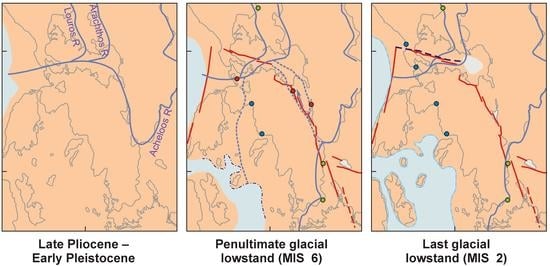
Figure 10.
Maps showing inferred evolution of the drainage system through the Quaternary, based on our heavy mineral studies and supplementary information from [4,32,33,51]. Paleoshorelines in Echinadon Sea from [19], Katouna–Stamna fault zone from [3].


Table 1.
Point counting * of thin sections of unprocessed bulk sand samples (percentages).
| Lithic Clasts | Minerals | |||||||||||||||
|---|---|---|---|---|---|---|---|---|---|---|---|---|---|---|---|---|
| Sample No. | Location | Carbonate | Chert | Other Sedimentary | Igneous + Metam. | Amphibole | Biotite | Chlorite | Epidote | Feldspars | Muscovite | Olivine | Opaque Oxides | Monocrystal. Qz | Polycrystalline Qz | Titanite |
| 5 | lower Evinos | 35.0 | 0.7 | 22.1 | 0.0 | 0.0 | 0.0 | 0.0 | 0.2 | 0.7 | 0.0 | 0.0 | 13.5 | 19.8 | 8.0 | 0.3 |
| 18 | lower Acheloos | 36.2 | 0.3 | 30.7 | 0.0 | 0.3 | 0.0 | 0.2 | 0.0 | 1.0 | 0.7 | 0.2 | 5.2 | 21.0 | 4.2 | 0.0 |
| 11 | lower Louros | 21.0 | 0.3 | 32.7 | 1.5 | 0.0 | 0.0 | 0.2 | 0.0 | 2.3 | 0.0 | 0.3 | 5.2 | 27.5 | 9.0 | 0.2 |
| 8 | upper Louros | 21.5 | 0.0 | 61.5 | 0.0 | 0.3 | 0.0 | 0.3 | 0.0 | 0.5 | 0.0 | 0.0 | 3.8 | 8.8 | 3.3 | 0.0 |
| 9 | upper Arachthos | 38.3 | 0.7 | 33.2 | 0.7 | 0.2 | 0.0 | 0.0 | 0.0 | 0.2 | 0.2 | 0.0 | 4.3 | 20.2 | 2.0 | 0.0 |
| 10 | upper Arachthos | 31.8 | 0.7 | 41.1 | 0.2 | 0.0 | 1.7 | 0.8 | 0.0 | 0.7 | 0.0 | 0.2 | 2.2 | 17.5 | 2.8 | 0.3 |
| 12 | Monolithos beach | 19.8 | 4.7 | 53.1 | 1.5 | 0.0 | 0.0 | 0.0 | 0.0 | 0.5 | 0.2 | 0.0 | 1.7 | 13.8 | 4.7 | 0.0 |
| 15 | Aktion beach | 9.2 | 7.3 | 44.7 | 0.0 | 0.0 | 0.0 | 0.0 | 0.0 | 1.3 | 0.0 | 0.0 | 2.7 | 24.0 | 10.8 | 0.0 |
| 17 | Ag. Nikolaos terrace | 35.0 | 3.8 | 55.9 | 0.0 | 0.0 | 0.0 | 0.2 | 0.0 | 0.0 | 0.0 | 0.0 | 1.2 | 1.2 | 2.7 | 0.0 |
* based on point counting of 600 points of the unprocessed sand sample.
Table 2.
Modal abundance of heavy mineral grains *.
| Sample No. | Location Name | Staurolite | Zircon | Titanite | “Rutile” | Ilmenie | Fluorite | Barite | Sphalerite | Cassiterite | Amphibole | Gedrite | Glaucophane | Apatite | Chromite | Spinel | Epidote |
|---|---|---|---|---|---|---|---|---|---|---|---|---|---|---|---|---|---|
| % of Total Detrital Heavy Minerals (Less Titanomagnetite and Magnetite) | |||||||||||||||||
| 5 | lower Evinos | 0.0 | 2.0 | 3.9 | 6.5 | 0.3 | 1.3 | 1.0 | 0.0 | 0.0 | 1.0 | 0.0 | 0.0 | 7.2 | 10.4 | 7.2 | 20.2 |
| 22 | middle Acheloos | 0.0 | 12.5 | 3.3 | 8.6 | 12.8 | 0.0 | 0.0 | 0.0 | 0.3 | 1.0 | 0.3 | 0.0 | 1.3 | 16.4 | 2.3 | 18.4 |
| 18 | lower Acheloos | 0.0 | 3.8 | 4.6 | 8.1 | 2.2 | 1.3 | 0.0 | 0.0 | 0.0 | 4.0 | 0.0 | 0.0 | 6.2 | 18.8 | 2.4 | 14.5 |
| 11 | lower Louros | 0.8 | 2.4 | 5.2 | 4.7 | 8.9 | 0.3 | 0.0 | 0.0 | 0.0 | 0.3 | 0.0 | 0.3 | 6.5 | 17.0 | 5.8 | 16.5 |
| 8 | upper Louros | 1.2 | 4.1 | 3.7 | 12.3 | 13.5 | 1.6 | 0.4 | 0.0 | 0.0 | 0.8 | 0.0 | 0.0 | 6.6 | 15.2 | 4.9 | 16.8 |
| 9 | upper Arachthos | 0.0 | 2.1 | 2.9 | 1.9 | 2.7 | 0.6 | 0.5 | 0.2 | 0.0 | 3.3 | 0.3 | 0.0 | 0.8 | 25.7 | 6.2 | 2.9 |
| 10 | upper Arachthos | 0.0 | 0.2 | 1.7 | 1.4 | 0.7 | 2.4 | 0.2 | 0.0 | 0.0 | 7.3 | 0.0 | 0.0 | 0.7 | 14.0 | 6.4 | 1.7 |
| 12 | Monolithos beach | 0.3 | 11.0 | 3.0 | 6.8 | 4.3 | 2.5 | 0.0 | 0.0 | 0.0 | 0.5 | 0.0 | 0.0 | 0.0 | 31.6 | 14.5 | 1.8 |
| 15 | Aktion beach | 0.0 | 0.7 | 3.5 | 5.7 | 3.2 | 8.1 | 0.0 | 0.0 | 0.0 | 2.1 | 0.0 | 0.4 | 0.4 | 7.1 | 6.4 | 10.6 |
| 25 | Pogonia beach | 2.7 | 3.2 | 2.9 | 6.4 | 16.3 | 0.0 | 0.0 | 0.0 | 0.0 | 1.4 | 0.0 | 0.0 | 0.9 | 24.6 | 9.5 | 13.9 |
| 26 | Mytikas beach | 1.7 | 3.0 | 7.2 | 6.2 | 7.2 | 0.0 | 0.0 | 0.0 | 0.2 | 3.5 | 0.0 | 0.0 | 5.9 | 11.4 | 5.7 | 31.4 |
| 17 | Ag. Nikolaos terr. | 0.2 | 1.5 | 5.1 | 2.7 | 8.1 | 0.7 | 0.0 | 0.0 | 0.0 | 2.9 | 1.2 | 0.0 | 2.9 | 24.4 | 11.5 | 23.2 |
| 24 | Loutraki terrace | 0.0 | 8.1 | 3.5 | 6.9 | 4.0 | 0.0 | 0.0 | 0.0 | 0.0 | 2.9 | 0.0 | 0.0 | 5.8 | 24.3 | 12.7 | 13.3 |
* counting the available heavy mineral sample. “Rutile” includes other TiO2 polymorphs.
Table 3.
Modal abundance of heavy mineral grains (continued).
| Sample No. | Location Name | Garnet | Tourmaline | Pumpellyite | Prehnite | Chalcopyrite | Allanite | Monazite | Clinopyroxene | Orthopyroxene | Olivine | Serpentinite | Talc/Magnesite | Total Counted | Titano-Mag. | Magnetite | Cr-Chlorite |
|---|---|---|---|---|---|---|---|---|---|---|---|---|---|---|---|---|---|
| % of Total Detrital Heavy Minerals (Less Titanomag. and Magnetite) | Others as % * | ||||||||||||||||
| 5 | lower Evinos | 32.2 | 2.9 | 0.7 | 0.0 | 0.7 | 0.7 | 0.0 | 1.0 | 0.7 | 0.3 | 0.0 | 0.0 | 310 | 0.0 | 1.0 | 0.0 |
| 22 | middle Acheloos | 17.8 | 3.9 | 0.0 | 0.0 | 0.0 | 0.0 | 1.0 | 0.0 | 0.0 | 0.0 | 0.0 | 0.0 | 304 | 0.0 | 0.0 | 0.3 |
| 18 | lower Acheloos | 28.0 | 4.6 | 0.0 | 0.0 | 0.0 | 0.0 | 0.3 | 1.3 | 0.0 | 0.0 | 0.0 | 0.0 | 380 | 0.0 | 2.2 | 0.0 |
| 11 | lower Louros | 24.9 | 2.9 | 0.0 | 0.0 | 0.0 | 0.0 | 0.0 | 2.4 | 0.5 | 0.8 | 0.0 | 0.0 | 396 | 1.0 | 2.6 | 0.0 |
| 8 | upper Louros | 18.0 | 0.8 | 0.0 | 0.0 | 0.0 | 0.0 | 0.0 | 0.0 | 0.0 | 0.0 | 0.0 | 0.0 | 294 | 0.0 | 20.5 | 0.0 |
| 9 | upper Arachthos | 7.9 | 0.5 | 0.0 | 0.0 | 0.0 | 0.0 | 0.2 | 12.2 | 5.1 | 22.8 | 1.1 | 0.3 | 671 | 2.2 | 4.1 | 0.2 |
| 10 | upper Arachthos | 5.7 | 0.7 | 0.0 | 0.2 | 0.0 | 0.0 | 0.0 | 8.8 | 10.0 | 37.9 | 0.0 | 0.0 | 431 | 0.9 | 1.2 | 0.0 |
| 12 | Monolithos beach | 17.8 | 0.3 | 0.0 | 0.0 | 0.0 | 0.0 | 0.0 | 0.3 | 5.5 | 0.0 | 0.0 | 0.0 | 401 | 0.0 | 0.5 | 1.5 |
| 15 | Aktion beach | 7.4 | 1.4 | 0.0 | 0.0 | 0.0 | 0.0 | 0.0 | 6.4 | 36.7 | 0.0 | 0.0 | 0.0 | 283 | 0.0 | 0.0 | 1.1 |
| 25 | Pogonia beach | 8.6 | 1.6 | 0.0 | 0.0 | 0.0 | 0.5 | 0.9 | 1.1 | 5.0 | 0.2 | 0.2 | 0.2 | 561 | 0.0 | 0.2 | 1.1 |
| 26 | Mytikas beach | 7.4 | 2.2 | 0.0 | 0.0 | 0.0 | 0.0 | 0.0 | 5.0 | 1.5 | 0.2 | 0.2 | 0.0 | 409 | 0.5 | 0.7 | 0.7 |
| 17 | Ag. Nikolaos terr. | 13.4 | 0.0 | 0.0 | 0.0 | 0.0 | 0.0 | 0.0 | 1.0 | 0.2 | 0.0 | 0.0 | 0.7 | 409 | 0.0 | 0.0 | 2.0 |
| 24 | Loutraki terrace | 16.2 | 1.2 | 0.0 | 0.0 | 0.0 | 0.0 | 0.0 | 0.6 | 0.6 | 0.0 | 0.0 | 0.0 | 176 | 0.6 | 1.2 | 0.0 |
* These other minerals expressed as % of heavy mineral total. Magnetite and titanomagnetite are very liable to alter to limonite.
Table 4.
Modal abundance of types of lithic clast in the 63–180 μm heavy fraction.
| Percentage * | |||||||
|---|---|---|---|---|---|---|---|
| Sample | Location | Total Counts | Hydrothermal | Igneous | Metamorphic | Ophiolitic | Sedimentary |
| 5 | lower Evinos | 22 | 18 | 18 | 50 | 0 | 14 |
| 22 | middle Acheloos | 22 | 14 | 14 | 36 | 5 | 32 |
| 18 | lower Acheloos | 35 | 43 | 9 | 31 | 3 | 14 |
| 11 | lower Louros | 29 | 34 | 7 | 52 | 3 | 3 |
| 8 | upper Louros | 37 | 22 | 5 | 54 | 0 | 19 |
| 9 | upper Arachthos | 58 | 9 | 31 | 31 | 26 | 3 |
| 10 | upper Arachthos | 26 | 0 | 8 | 31 | 54 | 8 |
| 12 | Monolithos beach | 22 | 18 | 5 | 59 | 18 | 0 |
| 15 | Aktion beach | 31 | 35 | 3 | 39 | 16 | 6 |
| 25 | Pogonia beach | 24 | 8 | 0 | 54 | 29 | 8 |
| 26 | Mytikas beach | 11 | 18 | 9 | 64 | 9 | 0 |
| 17 | Ag. Nikolaos terr. | 39 | 44 | 3 | 38 | 15 | 0 |
| 24 | Loutraki terrace | 8 | 63 | 13 | 0 | 0 | 25 |
* Definition of types is given in Section 4.5.
Publisher’s Note: MDPI stays neutral with regard to jurisdictional claims in published maps and institutional affiliations. |
© 2022 by the authors. Licensee MDPI, Basel, Switzerland. This article is an open access article distributed under the terms and conditions of the Creative Commons Attribution (CC BY) license (https://creativecommons.org/licenses/by/4.0/).
Share and Cite
MDPI and ACS Style
Piper, D.J.W.; Pe-Piper, G. The Response of the Rivers of NW Greece to Late Quaternary Neotectonics, as Interpreted from Detrital Petrology. Geosciences 2022, 12, 392. https://doi.org/10.3390/geosciences12110392
AMA Style
Piper DJW, Pe-Piper G. The Response of the Rivers of NW Greece to Late Quaternary Neotectonics, as Interpreted from Detrital Petrology. Geosciences. 2022; 12(11):392. https://doi.org/10.3390/geosciences12110392
Chicago/Turabian StylePiper, David J. W., and Georgia Pe-Piper. 2022. "The Response of the Rivers of NW Greece to Late Quaternary Neotectonics, as Interpreted from Detrital Petrology" Geosciences 12, no. 11: 392. https://doi.org/10.3390/geosciences12110392
Note that from the first issue of 2016, this journal uses article numbers instead of page numbers. See further details here.