Article

From Cultural Landscape to Aspiring Geopark: 15 Years of Community-Based Landscape Tourism in Fengnan Village, Hualien County, Taiwan (2006–2021)

by
Kuang-Chung Lee
* and
Paulina G. Karimova
College of Environmental Studies, National Dong Hwa University, Shoufeng Township, Hualien County 974301, Taiwan
*
Author to whom correspondence should be addressed.
Geosciences 2021, 11(8), 310; https://doi.org/10.3390/geosciences11080310
Submission received: 3 June 2021 / Revised: 12 July 2021 / Accepted: 21 July 2021 / Published: 25 July 2021
(This article belongs to the Special Issue From Geoheritage to Geotourism—New Advances and Emerging Challenges)

Abstract

:
Geoconservation plays a key role in valuing and conserving abiotic nature, while geotourism can be an effective means of achieving this objective. Connectivity between biophysical and socio-economic components and a community-based perspective on appreciation and interpretation of landscape resources are important yet not well understood. This study is a retrospective analysis of 15 years (2006–2021) of integrated landscape management in Fengnan Village, Hualien County, Taiwan, with a focus on the evolution of multi-stakeholder perception of local geodiversity and emergence of geotourism as part of community-based landscape tourism in the area. A qualitative multiple-method approach to data collection and analysis was based on the “know–cherish–show” interpretation model and the theory of collaborative planning. The results demonstrate that (a) geoconservation and geotourism have evolved to become an integral part of the Fengnan living landscape, while connectivity between nature–culture attributes has strengthened over the years; (b) multi-stakeholder collaboration and knowledge-bridging are characteristic features of the institutional arrangement; and (c) facilitating the role of the bridging stakeholder (the authors) was central to the timely introduction of various landscape concepts for long-term geoconservation in the area.

1. Introduction

Understanding and appreciation of both the biotic and abiotic components of nature are critical for realizing the 2050 Vision of “Living in harmony with nature” [1]. Starting from the 1980s, pro-active geoconservation efforts have been led by the European Association for the Conservation of the Geological Heritage (ProGEO), International Union for Conservation of Nature (IUCN), and the United Nations Educational, Scientific and Cultural Organization (UNESCO) [2]. Societal recognition of geodiversity, however, is still lagging behind [3] as a “conservation of second importance” compared to existing biodiversity conservation strategies and policies [2].
Geodiversity is defined by M. Gray (2013) as “the natural range (diversity) of geological (rocks, minerals, fossils), geomorphological (landforms, topography, physical processes), and soil and hydrological features. It includes their assemblages, structures, systems, and contributions to landscapes” [4]. Positioning of geodiversity within a landscape context is an important takeaway message from this definition.
There are various ways to communicate the value of geodiversity to the public [5,6]. The concept of abiotic ecosystem services (regulating, supporting, provisioning, cultural, and knowledge) [6,7] is one of the ways that points out the societal dependence on geodiversity for its most basic needs: water quality regulation, soil fertility, fuel, construction and industrial materials, cultural and spiritual meanings, understanding of Earth’s history, and many others [6,8]. Geotourism, as a cultural ecosystem service of abiotic nature [9], is also a valuable means to enhance our understanding and appreciation of geodiversity [5,10].
The term geotourism was first introduced in 1995 by T.A. Hose [11]. It has evolved over the years to be regarded in either narrower (interpretive services for understanding geology or geomorphology of the site for professional and non-professional audience) [11,12] or broader (encompassing environment, culture, aesthetics, heritage, and well-being of local residents) sense [13,14]. These two angles of defining geotourism also determine its relationship to other forms of nature tourism—ecotourism, cultural tourism, tribal tourism, adventure tourism, etc. [14,15,16]. Notwithstanding the contentious nature of its theoretical definition, what geotourism implies in practice should stem from specific geoconservation objectives at a given site and from its relationship to the landscape as “a form of natural area tourism that specifically focuses on landscape and geology” [13].
Placement of geodiversity within a landscape context implies that it needs to be viewed in a more holistic sense and through interconnection with other non-human and human elements [8,17,18]. In recent years, numerous studies have paved the way to discerning the functional links between geodiversity and biodiversity [4,9,19,20] and the combination of the two for successful nature conservation outcomes in protected areas [19]. It is no less important, however, to consider the linkage between biophysical and socio-economic components as a part of a coupled human–nature system [18,21,22] that comprises a landscape. In this regard, we observe several research gaps in the existing geoconservation and geotourism literature.
First, there is a much greater emphasis on a “stand-alone geoconservation” led by geologists and other natural scientists [16,20], as opposed to a holistic perspective of integrated landscape management with the inclusion of its living and dynamic features. This makes one wonder how geodiversity relates to other aspects of nature–culture conservation in the area and whether it would be more effective once such links are clearly identified. In addition, how is geotourism placed within the context of other tourism activities in a landscape?
Second, existing connotations of geotourism, however, narrow or broad, focus primarily on the receiving end of the equation: specialist tourists and general visitors [8,10,16,23]. Tourist satisfaction and education through geo-interpretation is by no means important for closing the gap in the societal appreciation of geodiversity [12]. However, there is less accentuation of what geodiversity means to the local people inhabiting a landscape [20]. How is geodiversity understood and appreciated by those who have a direct everyday real-life interaction with it? Does the mere fact of living within a geodiverse landscape imply knowing, understanding, and appreciating it?
Third, based on the above, the role of local communities in geoconservation is still rather limited and functional [20]. “Locally beneficial” is one of the geotourism principles [13] that implies employment of the local people as guides, geo-interpreters, or local entrepreneurs to serve geotourism facilities [23,24]. Despite its “community-based” disguise, most geotourism practices place geotourism industry’s interests above those of community empowerment [24,25]. Is community-based geo-interpretation a mere “reading from the script” of local geodiversity? Or is it a process of the understanding, appreciation, and sharing of geo-knowledge through the “lived through” experiences of and by the local people?
Finally, there is a limited understanding of how geoconservation objectives are introduced and how various actors cooperate within a living landscape setting [20]. Is it a straightforward process of identifying geodiversity values and putting the institutional mechanisms in place? Or is it a gradual formation of institutional capacity for geoconservation planning and management over time?
In this article, we aim to address the above gaps by demonstrating 15 years of our on-the-ground experience with a living nature–culture landscape in Fengnan Village, Hualien County, Taiwan. As an initiator, observer, and facilitator for its integrated landscape management, our team from National Dong Hwa University (NDHU, the authors) has maintained consistent engagement in the area from 2006 until now (2021). The purpose of this study was to elicit how community-based landscape tourism and related landscape concepts (i.e., cultural landscape, socio-ecological production landscape of the Satoyama Initiative, IUCN Category V Protected Landscape, and geopark) have led to the understanding and appreciation of Fengnan geodiversity by multiple actors involved in the area.
The study poses the following research questions:
  • How can the “know–cherish–show” community-based landscape tourism and interpretation model help to elicit the place of geodiversity and geotourism in their relation to other landscape resources?
  • What are the lessons learned from the long-term institutional arrangement between primary and secondary stakeholders for the integrated landscape management in Fengnan Village?
  • What is the role of the bridging stakeholder (NDHU) and of various landscape concepts applied as engagement techniques over the years?
In the following section, we provide a description of the case study area and outline the terms, concepts, and methods used in the study (Section 2). Then, we present the phase-based results of our long-term engagement in Fengnan Village (2006–2011, 2011–2018, and 2018–2021) through the prism of the “know–cherish–show” community-based landscape tourism and interpretation model (Section 3) and discuss the results in relation to the research questions and existing research gaps (Section 4). In Section 5, we conclude with the lessons learned, remaining challenges, and suggestions for future study.
We note that our field of expertise is landscape conservation and community participation with a particular emphasis on multi-stakeholder collaboration and capacity-building. This explains why we placed our focus on cooperation between primary and secondary stakeholders in the area rather than on tourists and recipient-related outcomes of geotourism activities. To stay within the thematic scope of this article and provide a retrospective analysis of our efforts, we omitted the results and discussion of other objectives targeted by the integrated landscape management activities over the years. Detailed contents and outcomes of each phase are presented in our published articles (in English and Chinese) that are referenced where applicable throughout the text of this manuscript.

2. Materials and Methods

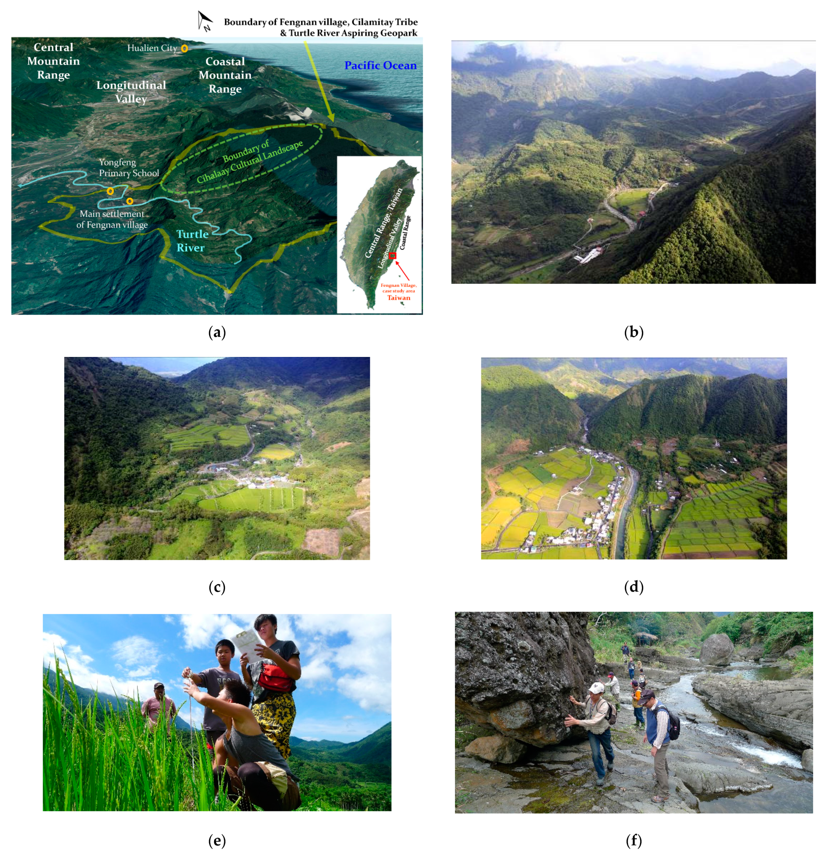
2.1. Description of the Case Study Area: Fengnan Village, Hualien County, Taiwan

Taiwan Island is located on the western edge of the Pacific Rim of Fire within the subduction zone and the junction of the Philippine Sea Plate and the Eurasian Plate [26], while the case study area is situated in one of the most tectonically active, eastern, parts of the country, the southern Coastal Mountain Range, Hualien County.
Fengnan Village covers an area of 3500 hectares, occupies the upper and middle reaches of the Turtle River watershed (northern part of the Taiyuan Basin) and spreads across the Coastal Mountain Range and the Longitudinal Valley (Figure 1a). In addition to possessing one of the highest uplifting rates in the world and a high frequency of earthquakes [27], the area is also subject to rapid surface erosion processes caused by seasonal heavy rainfalls and tropical cyclones (typhoons) [28].
Due to their unique geological and geomorphological features, the Turtle River watershed, the Taiyuan Basin, and the Coastal Mountain Range all have been the subject of rigorous research by domestic and foreign scholars for nearly half a century [29]. For instance, numerous studies have focused on a thick volcaniclastic and siliciclastic sequence that preserves the depositional records of the Luzon forearc that is well exposed in the Taiyuan Basin [30]. With relatively little destruction by land-use activities, this area is regarded as the key to unveiling the evolution of Taiwan’s arc-continent collision terrane [29,31,32]. History of the Turtle River terraces [33], monitoring of the active Chihshang fault [34], rich and diverse fluvial geomorphological features (such as gorge, high-altitude gentle undulating surfaces, and unstable watershed divides) [35] have also been the subject of extensive studies and geo-education activities over the years.
The Turtle River catchment is primarily composed of mountains, shallow hills, river terraces, and river alluvial plains (Figure 1b–d). The natural integrity of mountainous areas above 500 m is well preserved with the forests and streams protected and managed by the Forestry Bureau, Council of Agriculture. The highest peak of the Coastal Mountain Range—Malaolou—is located at 1682 m on the eastern edge of the Fengnan area. Farming and gathering activities of the locals take place within shallow hilly areas below 500 m, while the settlements and paddy fields are situated along the river terraces and river alluvial plains (Figure 1d) [36].
Fengnan Village is comprised of 288 households with a registered population of 663 residents, 63% of which are Indigenous Amis [37], well-known for their traditional hunting, farming, and gathering skills as well as their knowledge of wild plants. The Cihalaay Tribe (1000 hectares) is a distinctive socio-ecological production landscape (SEPL) with close interactions between the local people, their land-use practices, and natural surroundings (Figure 1c). The Cihalaay community is largely dependent on local landscape resources for its sustainable livelihoods as even its name derives from “Hala”—an endemic protected fish species discovered in the stream by Cihalaay ancestors [38].
Location of rice terraces atop the sloping hills is a characteristic feature of Cihalaay SEPL as most paddy fields in eastern Taiwan are spread across alluvial plains or river terraces. Stone walling structures of some terraced fields have remained intact over the years and serve as a living testament to the traditional building skills of the early settlers and as a link between local livelihoods and geodiversity. Both socio-cultural and biophysical attributes of the Fengnan area explain the need for its conservation and promotion as a unique living cultural landscape.

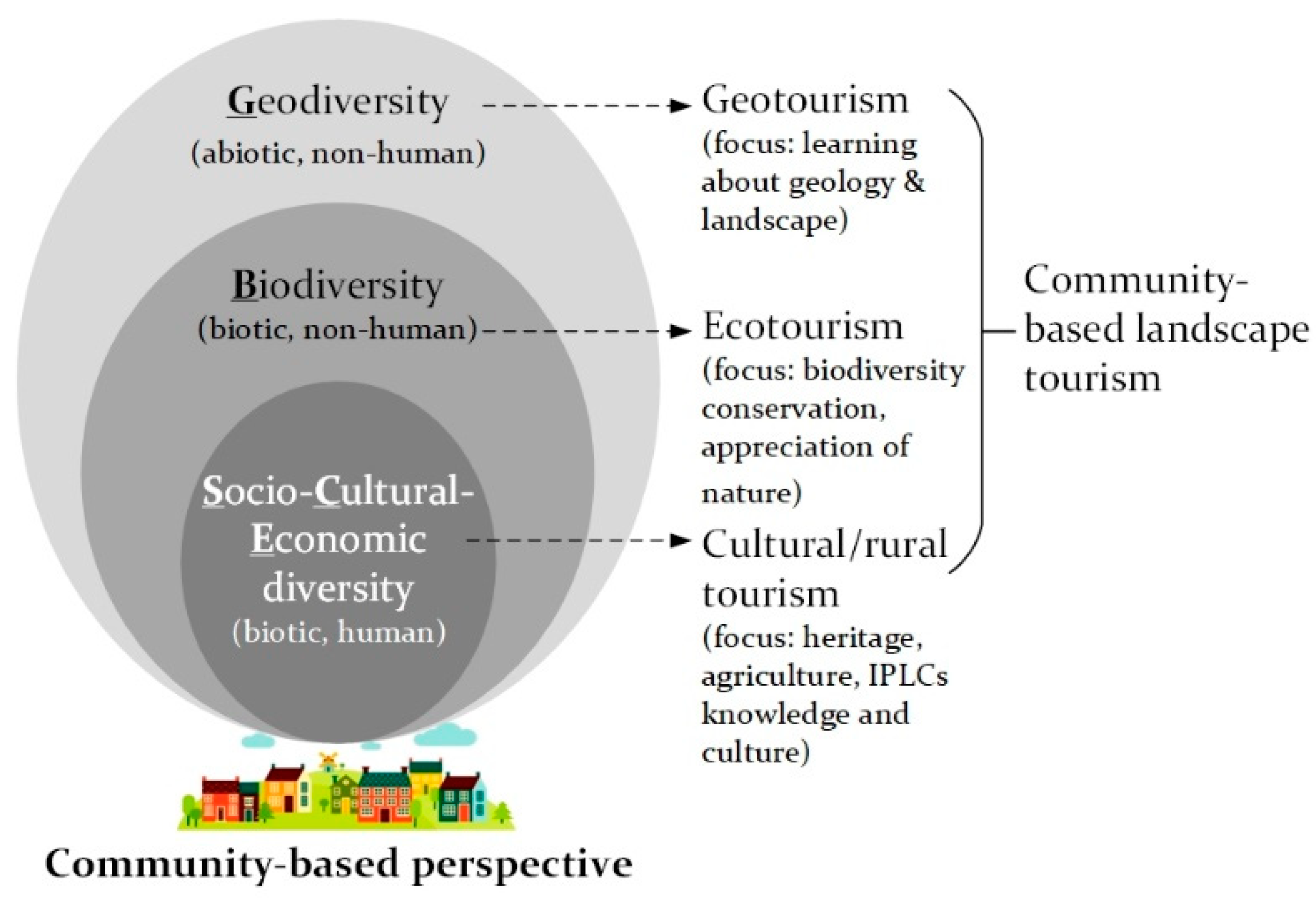
2.2. Definition of Terms and Concepts

Within the scope of our study, we defined landscape as a socio–cultural–biophysical system situated within defined geographic boundaries and comprised of human and non-human interactions within its geo, bio, and socio dimensions [21,22,39]. Based on M.B. Usher’s (2001) [40] “geosphere”, “biosphere”, and “anthroposphere” and D. O’Hare’s (1997) [41] nature–culture connectivity within a cultural landscape, we conceptualized the socio–cultural–biophysical system of a living landscape (Figure 2). There, geodiversity (G) acts as a “biophysical stage” or an abiotic background that hosts biotic elements: non-human (biodiversity, B) and human—local community with its cultural, social, and economic diversities (SCE). The spheres are shifted to the bottom to reflect the community-based bottom-up vision, which also coincides with the initial level of the community’s relative proximity to and familiarity with them: from the closest and most understood (SCE), relatively understood (B) to the farthest and least understood (G).
We used the term community-based landscape tourism to refer to all types of tourism present in the landscape, which are planned and managed by and for the livelihood benefits (social, economic, and environmental) of the local community [24,25,41]. Community-based landscape tourism may be viewed as a sum of cultural/rural tourism, ecotourism, and geotourism directed at understanding, appreciating, and interpreting all of (or a combination of some) the biophysical and socio-cultural elements present in the landscape. Carried out from the community-based perspective, ecotourism and geotourism, despite their biophysical foci as subtypes of nature tourism (Figure 2), also encompass a distinctive socio-cultural and economic dimension and are inextricably linked to cultural/rural tourism [42,43].
Throughout 2006–2021, our team employed several landscape concepts as engagement techniques in Fengnan Village, which included cultural landscape, socio-ecological production landscapes and seascapes (SEPLS) of the Satoyama Initiative, IUCN Category V Protected Landscape, and geopark. Here, we briefly outline the meaning of each concept in its application to the case study area.
Prolonged and “intimate relationship between people and their natural environment” [44] is central to the understanding of cultural landscapes [8,40,45]. In Taiwan, the cultural landscape concept received its legal recognition in the 2005 amendment of the Cultural Heritage Preservation Act (CHPA) as “the location or environment which is related to any myths, legends, record of events, historical events, social life or ceremonies” [46]. Official promulgation of cultural landscapes as the instrument for the conservation of living landscapes in Taiwan was central to its application for the “Fengnan Aspiring Cultural Landscape” Phase I (2006–2011).
SEPLS are “dynamic biocultural mosaics of habitats and land and sea uses where the interaction between people and the landscape (seascape) maintains or enhances biodiversity while providing humans with the goods and services needed for their well-being” [47]. Since 2010, they have been promoted by the Satoyama Initiative as the landscape–seascape-sized coupled human–nature systems with an emphasis on biodiversity conservation by the means of sustainable production activities [48]. The concept of SEPL (no seascape in the Fengnan case) and IUCN Category V Protected Landscape (as the one closest to SEPLS and the Satoyama Initiative) were helpful during “Cihalaay Cultural Landscape” Phase II (2011–2018).
The term geopark was added as an amendment to Chapter 6, Article 78 of Taiwan’s CHPA in July 2016 [46] though its clear legal definition is still lacking to date. In the Fengnan context, we built upon UNESCO’s interpretation of the term [49] and applied this long-awaited legal instrument as a landscape concept for “Turtle River Aspiring Geopark” Phase III (2018–2021, ongoing).

2.3. Research Methodology

This study is a long-term participatory action research carried out in Fengnan Village, Hualien County, Taiwan from July 2006 to December 2021 (ongoing). Action research is a qualitative method that implies a reflective linkage between the on-the-ground action and the academic study of the researched phenomenon [50]. This method provided for our dual role in the Fengnan area—as both facilitators (bridging stakeholder) and researchers.
Several action research frameworks have been operationalized over the years, of which the most substantial for the scope of this article are the “know–cherish–show” community-based landscape interpretation model revised from F. Tilden’s (1957) theory of heritage interpretation [51] and institutional capacity analysis based on P. Healey’s (1998, 2002) [52] theory of collaborative planning.
The “know–cherish–show” model implies understanding of local landscape resources by the local community, appreciation of their value to the community, and the ability of the local community to interpret these resources and their values to the visitors. Our revision of Tilden’s (1957) original phrase—“through interpretation, understanding; through understanding, appreciation; through appreciation protection” [51]—shifts away from the recipient focus of environmental interpretation and distinctly places the emphasis on a community-based perspective. The model has been consistently used for the implementation and analysis of capacity-building activities throughout all three phases of the study.
P. Healey’s (1998, 2002) theory of collaborative planning served as a basis for evaluating the existing and developing a new institutional capacity among primary and secondary stakeholders. Social capital (relational resources), intellectual capital (knowledge resources), and political capital (mobilization capacity) [53] are the three criteria adopted for enhancing participatory planning and management of community-based geotourism and geoconservation over time.
We employed the qualitative multiple-method approach to data collection and analysis throughout all three phases of integrated landscape management in Fengnan Village in the periods 2006–2011, 2011–2018, and 2018–2021. The qualitative method was the most suitable for providing an in-depth insight into “inner experiences”, “language”, “cultural meanings”, and “forms of social interaction” among stakeholders [54,55]. Multiple methods consisted of desktop data analysis, field surveys, participant observation, individual interviews, workshops, and group discussions [56,57]. These were combined in various ways to better achieve on-the-ground and intellectual objectives of every phase of the action research. Several triangulation strategies were also used to minimize the risk of validity threats [50,58].
To maintain a retrospective focus of this longitudinal study, we provide a concise summary of each phase in Table 1, which outlines the relevant sub-phases, landscape concepts applied, brief contents, stakeholders involved, “know–cherish–show” model with a particular emphasis on the appreciation of geodiversity (G) and related outcomes. A detailed information on multiple methods and materials of each phase may be found in the relevant publications also listed in Table 1 and in the description of activities in Section 3.

3. Results

In this section, we describe the three phases of integrated landscape management and community-based landscape tourism activities in Fengnan Village: Fengnan Aspiring Cultural Landscape (phase I: 2006-2011), Cihalaay Cultural Landscape (phase II: 2011–2018), and Turtle River Aspiring Geopark (phase III: 2018–2021, ongoing) (Table 1).
In Figure 3, we demonstrate these phases on a time scale and in relation to the level of understanding (“know”), appreciation (“cherish”), and interpretation (“show”) of the Fengnan landscape resources by the local community. It supplements Table 1 by pinpointing the “know–cherish–show” model of community-based landscape interpretation. The focal landscape resources and the connectivity between them and related forms of landscape tourism are also indicated. In line with Figure 2 and Table 1, here, SCE (socio-cultural-economic diversity) stands for the biotic human component and cultural/rural tourism, B (biodiversity) for the biotic non-human component and ecotourism, and G (geodiversity) for the abiotic non-human component and geotourism.

3.1. Phase I: 2006–2011: Fengnan Aspiring Cultural Landscape

Uniqueness of biophysical and socio-cultural characteristics of Fengnan Village (Section 2.1) as well as the picturesque beauty of its landscape is what motivated our initial interest in the area prior to 2006. It was essential though to find a suitable engagement technique to kindle the dialogue with the local people and bring attention to the richness of their biotic and abiotic landscape resources.
Despite our expert interest in the geodiversity of the area as well as the scientific and educational value of Fengnan geomorphology [31,32,33], we began our involvement not from the geopark but from the cultural landscape concept. The main rationale for this choice was that geopark, as a legal instrument for conserving abiotic nature in Taiwan, had not been promulgated until ten years later as a 2016 amendment to CHPA. Another explanation was a relative “remoteness” and a lesser level of understanding of geodiversity (G) by the local community compared to their abundant knowledge about socio-cultural (SCE) and ecological (B) resources of the area (Figure 2).
Aware of our role as a bridging stakeholder who was new to the area, we realized that the introduction of any landscape concept had to follow the pace of the local people and respect their boundaries by allowing them a sufficient time for understanding, appreciating, and being able to interpret their landscape resources. For this reason, during phase I (2006–2011), we did not intend to designate a cultural landscape, but rather to explore a potential for its designation in the future (Table 1). Relevant activities of the phase may be divided into two sub-phases: (2006–2008) collaborative landscape resource inventory by the means of field surveys, workshops, and interviews as a basis for future community-based landscape tourism activities and place-based education; and (2009–2011) community–school–university partnership for the capacity-building of landscape interpretation skills of the local people, students, and teachers [36].
The landscape resources inventory revealed four categories of resources: cultural (the building of Yongfeng Primary School, Cilamitay Community Center, Earth God Temple, etc.) and production resources (e.g., organic rice, plums, and persimmons, wild-harvested bamboo, Indigenous Amis handicrafts, etc.) within the SCE component; ecological resources (rattan trees and edible wild plants, faunal inhabitants of the Turtle River watershed: endemic Hala fish, river crab, freshwater soft-shelled turtle, freshwater shrimp, etc.)—component B; and scenic resources (terraced paddy fields, “Sleeping Beauty” Mountain, Stone Gate Channel, waterfalls, Small Tianxiang Gorge, etc.)—component G [36].
Capacity-building of landscape interpretation skills focused on addressing the landscape resources most familiar to and well-understood by the local people—cultural, production, and ecological. As skilled gatherers, hunters, and fishers, the Indigenous Amis people of Fengnan Village could easily interpret their rich local culture in the context of cultural/rural tourism and ecotourism. At the time, appreciation of geodiversity (G) by the local people was limited to it being a “beautiful scenic resource” and an attracting factor for the visitors. The scenic landscape sites were briefly mentioned as a part of early cultural tourism and ecotourism activities, but no specially designed geo-interpretation was provided at the time. This explains why in Figure 3 the culture (C) and biodiversity (B) were the focal resources of the phase, while G remained in the background. In addition, connectivity between various landscape resources and their relevant inclusion into community-based landscape tourism activities was not yet evident (Figure 3).
NDHU acted as a bridging stakeholder between the Fengnan Community Development Association and Yongfeng Primary School (primary stakeholders) and Hualien Forest District Office of the Forestry Bureau (HFDOFB) and Ministry of Education and Council for Cultural Affairs (secondary stakeholders). Activities of the phase (community forestry projects and place-based outdoor workshops) were financially supported by HFDOFB, Ministry of Education and, to a limited extent, by the Council of Cultural Affairs.
Laying out a solid foundation for the “local–local” institutional capacity among primary stakeholders was one of the main outcomes of the phase. This may be attributed to a pro-active role of NDHU in facilitating a community–school–university partnership for local capacity-building [36]. In 2009–2011, due to the leadership changes at Yongfeng Primary School, its principal pulled back from the triangular partnership arrangement, however, NDHU continued to work with the local community on a bilateral basis. Community-based interpretation workshops where NDHU students acted as planning partners and tourists are an example of the continuous partnership with the locals.

3.2. Phase II: 2011–2018: Cihalaay Cultural Landscape

Assessment of the Fengnan cultural landscape potential during the initial five years of our engagement in Fengnan Village allowed us to observe its distinctive nature–culture characteristics [38,59,61]. By 2011, the local people also possessed a sufficient level of familiarity with the concept and knowledge of their landscape resources in order to take the next step—designation of the Cihalaay Cultural Landscape. Worth noting though, as is evident from Figure 1a, the Cihalaay Tribe is a smaller area (1000 ha) within the Fengnan landscape (3500 ha). The reasons for choosing Cihalaay for cultural landscape designation can be explained, on one hand, by a high degree of nature–culture representativeness of its landscape elements and, on the other hand, by a relative simplicity of its stakeholder composition compared to a larger Fengnan Village.
During Phase II, in addition to cultural landscape, we also introduced the concept of SEPL and the Satoyama Initiative (Table 1) [47,60]. Its emphasis on conservation and sustainable use of landscape resources for the benefit of biodiversity and human well-being [47,48] brought a previously less accentuated element of eco-friendly production into the spotlight. IUCN Category V Protected Landscapes management guidelines [68,69,70] and the six-step ladder of community engagement [71] also served as a helpful guide in the process.
Landscape resources inventory by the means of field surveys, interviews, and public participation geographic information system (PPGIS) techniques was performed as part of the issue identification stage [61] at the beginning of Phase II (2011). This was followed by collaborative planning, official designation of the Cihalaay Cultural Landscape by the Cultural Heritage Review Committee of Hualien Cultural Affairs Bureau (2012), and community-based management and monitoring activities (2015) [62,63]. A 2012–2016 sub-phase involved a series of weekend community-based environmental education courses for Cilamitay Indigenous youth [62,64] that prioritized place-based education on the topics closely related to Cilamitay landscape resources: agricultural production and livelihoods, community and culture, landscape and nature conservation (Figure 1e). In addition, it was the first time that landscape interpretation capacity-building training was taught by the local Indigenous elders to the local Indigenous youngsters—a new type of local traditional ecological knowledge (TEK) transmission [64].
Understanding of the landscape resources during this phase was intricately linked to their value for the local community [38,60]. Ecological (B), economic, and cultural (SCE) values of the Cihalaay Cultural Landscape highlight its role in conservation and sustainable resource use. Connectivity between the SCE and B components is shown in Figure 3. It elicits the importance of sustainable agricultural, hunting, fishing, and gathering activities traditionally practiced by the Indigenous Amis Cihalaay community. SCE-B connectivity also reflects a newly discovered emphasis on the eco-agricultural production value of Cihalaay SEPL, promotion of cultural/rural tourism and ecotourism activities, and the marketing of green products.
The historical, representative, and rarity values of Cihalaay SEPL are associated with its SCE and G components (Figure 3). Unique irrigation channels (Stone Gate Channel) and irregular-sized rice terraces cut out in steep mountain slopes [60] are examples of long-term human and abiotic nature interactions in the area. Though not yet officially developed into geo-interpretation activities during Phase II, these “living and fossil cultural landscape” resources [60] were deeply appreciated by the local people. They served as a scenic background for their community-based landscape interpretation activities—told as a part of family history or as lyrics of a local Indigenous song [64]. Direct contribution of geodiversity (G) to local livelihoods as a source of drinking and irrigation water and as a building material was also clearly recognized at this stage.
Multiple stakeholders involved in Phase II included the Cihalaay Cultural Landscape Management Committee and Fengnan Community Development Association (primary stakeholders), Hualien Cultural Affairs Bureau, and HFDOFB (secondary stakeholders). The bridging role of NDHU was aimed at allowing a new type of institutional capacity (“local-governmental”) to emerge between the local people and the government agencies through official collaboration on the protection of local landscape resources in the name of the Cihalaay Cultural Landscape.
It is worth noting that in 2012, the same year that the Cihalaay Cultural Landscape was officially designated, our team initiated a two-year project commissioned by the Forestry Bureau titled “A study of national community-based geopark management and planning framework in light of international experiences” [72]. The aim of the project was to review international experiences (IUCN and UNESCO) in relation to the planning and management of geoparks and applying them to assess the Turtle River Geopark potential in Fengnan Village. During the first year of the project, the local community worked closely with various environmental NGOs from Hualien County. Together, they conducted an assessment of the Fengnan geodiversity resources and compiled a strong body of evidence confirming a high geopark potential of the area. However, due to the lack of required legal instruments (same reason as in 2006, Section 3.1), the project was discontinued after just one year.
Nevertheless, despite its cessation, the 2012 project resulted in a rich geo-knowledge database, stimulated community cohesion around the geodiversity topic, and promoted the partnership between Fengnan residents and Hualien NGOs. The one-year efforts not only enhanced the appreciation of geodiversity by the local community, but also paved the way to reintroduction of the geopark concept in 2018 when the institutional climate became favorable.

3.3. Phase III: 2018–2021: Turtle River Aspiring Geopark

In 2016, the geopark concept was officially added as an amendment to Chapter 6, Article 78 of CHPA and became the long-awaited legal instrument to value and conserve Taiwan’s abiotic nature [46]. It was finally time to reintroduce the idea of the Turtle River Geopark to Fengnan Village and thoroughly explore its geopark potential. The actual planning for geopark designation was not a goal of this—aspiring—stage, as it was to be aligned with and determined by the future aspirations of the Fengnan community itself.
Phase III (2018–2021) was viewed by multiple stakeholders as an opportunity to engage the whole of Fengnan Village as opposed to a smaller Cihalaay area during Phase II. This time, expanding the spatial scale of the approach was motivated by at least two factors. First, it was a response to the opposition voices coming from some Fengnan residents that “too much attention was paid to small Cihalaay Tribe.” Second, it meant consideration of a changed stakeholder composition and leadership shifts in Fengnan Village, where several newly emerged community organizations were eager to become involved.
Resource inventory as the key to the understanding of local landscape resources was conducted by means of field surveys and workshops with a particular focus on geodiversity (G) and its ecosystem services [65] (Table 1). Based on the inventory results and related discussions, five, and later three, core geodiversity areas were identified as potential geo-interpretation sites of the Turtle River Aspiring Geopark [29].
Ecosystem services analysis revealed that geodiversity component (G) was no longer perceived as merely a scenic resource or a landscape background, but was viewed as a source of vital services for community livelihoods [65]. For example, provisioning services were observed in the relationship between local water sources and geological composition and structure, between building materials used for terraced ridges or traditional houses and nearby rocks and soil, and between traditional irrigation channels and mudstone clay layers. Analysis of regulating services elicited connectivity between the surface- and groundwater system and regional folding and faulting structures and between fish habitats of streams, pools, and ripples and soft-hard rock interbedded structures. Cultural ecosystem services revealed the strongest linkage to local livelihoods and TEK with geodiversity reflected in local toponyms, Indigenous Amis folklore, hunting, fishing, and gathering practices, and in a sense of place and local pride (e.g., the Turtle River and the Small Tianxiang Gorge were seen as representative symbols of the area) [29,67].
Deepened understanding and appreciation of geodiversity (G) and its relationship to local livelihoods, history, and culture (SCE + G in Figure 3) further incited the Fengnan community’s interest in geo-interpretation. At that time, community-based landscape tourism in Fengnan Village was ready to fully encompass its abiotic boundaries and work toward the development of geotourism activities. Capacity-building for community-based geotourism, however, differed from capacity-building activities of the previous two phases. Due to an inherent complexity and a lesser familiarity of the local people with geo-terms (geodiversity, geology, geomorphology, geoconservation, geotourism, etc.), a substantial input from the expert knowledge was required [66].
To address this need, our team facilitated a series of geo-interpretation training workshops that included field expeditions and interactive lectures by an invited geology specialist [29,31]. This type of capacity-building exercise, on one hand, communicated a scientific vision of the unique geomorphological and geodiversity value of the area [62] and, on the other hand, highlighted an intrinsic interconnectedness between geodiversity (G) and other components (SCE and B) of the Fengnan landscape. Geodiversity was explained as a large “biophysical stage” (Figure 2) that accommodates the geological, topographic, hydrological, ecological, land-use, and socio-cultural features of the area.
Thus, with the help of experts, Fengnan locals were offered an opportunity to see the abiotic component of their familiar landscape in a new light. By further weaving their own TEK with expert knowledge, they began to gradually develop a new landscape (geo-) interpretation capacity and practice it via self-organized community-based geotourism activities throughout 2020 and 2021 (Figure 1f). In early 2021, the first geo-interpretation guidebook for the Turtle River Aspiring Geopark “Searching for roots in the mountain valley” [73] was published by the Fengnan community with assistance from NDHU and HFDOFB.
At this stage, along with geotourism and geo-interpretation development, the Fengnan community also began examining potential geo-products for promoting the aspiring geopark and generating additional income for the local people. Grown in an eco-friendly way on the sloping hills, and nurtured by a network of traditional irrigation channels adhering to local geological composition and structure, Hala rice paddies provide a habitat to the endemic protected Hala fish and are an indispensable part of Indigenous Amis traditions and culture. These features make Hala rice not only a frontrunner among potential geo-product options, but also a symbol of the Fengnan socio–cultural–biophysical landscape.
Establishment of a multi-stakeholder platform for collaborative governance of the Turtle River Aspiring Geopark is central to the institutional capacity outcomes of the current phase. Set up in 2020, the platform comprises ten local organizations from Fengnan Village as primary stakeholders (Cilamitay Tribal Chief Committee, Fengnan Village Office, Fengnan Community Development Association, Cilamitay Tribal Meeting, Cilamitay Tribal Cultural Association, Fengnan Neighborhood Watch Team, Fengnan Drinking Water Committee, Fengnan Country Estate Homestay, Yongfeng Primary School, and Manna Rural Living Experimental Hub) and 15 secondary stakeholders including HFDOFB, the Ninth River Management Office, and several NGOs (Geoparks Association of Taiwan, among them). The multi-stakeholder platform collaboratively plans, manages, monitors, and adjusts geotourism activities in the area, while its efforts have already led to the inclusion of the Turtle River Aspiring Geopark in the Taiwan Geoparks Network (2020) [74].

4. Discussion

In this section, we share the takeaway messages from our 15 years of experience with integrated landscape management in Fengnan Village based on the three research questions and addressing the existing research gaps (Section 1). Landscape resources of the Fengnan socio–cultural–biophysical system (SCE, B, and G) and the institutional arrangement between primary, secondary, and bridging stakeholders are conceptualized in Figure 4.

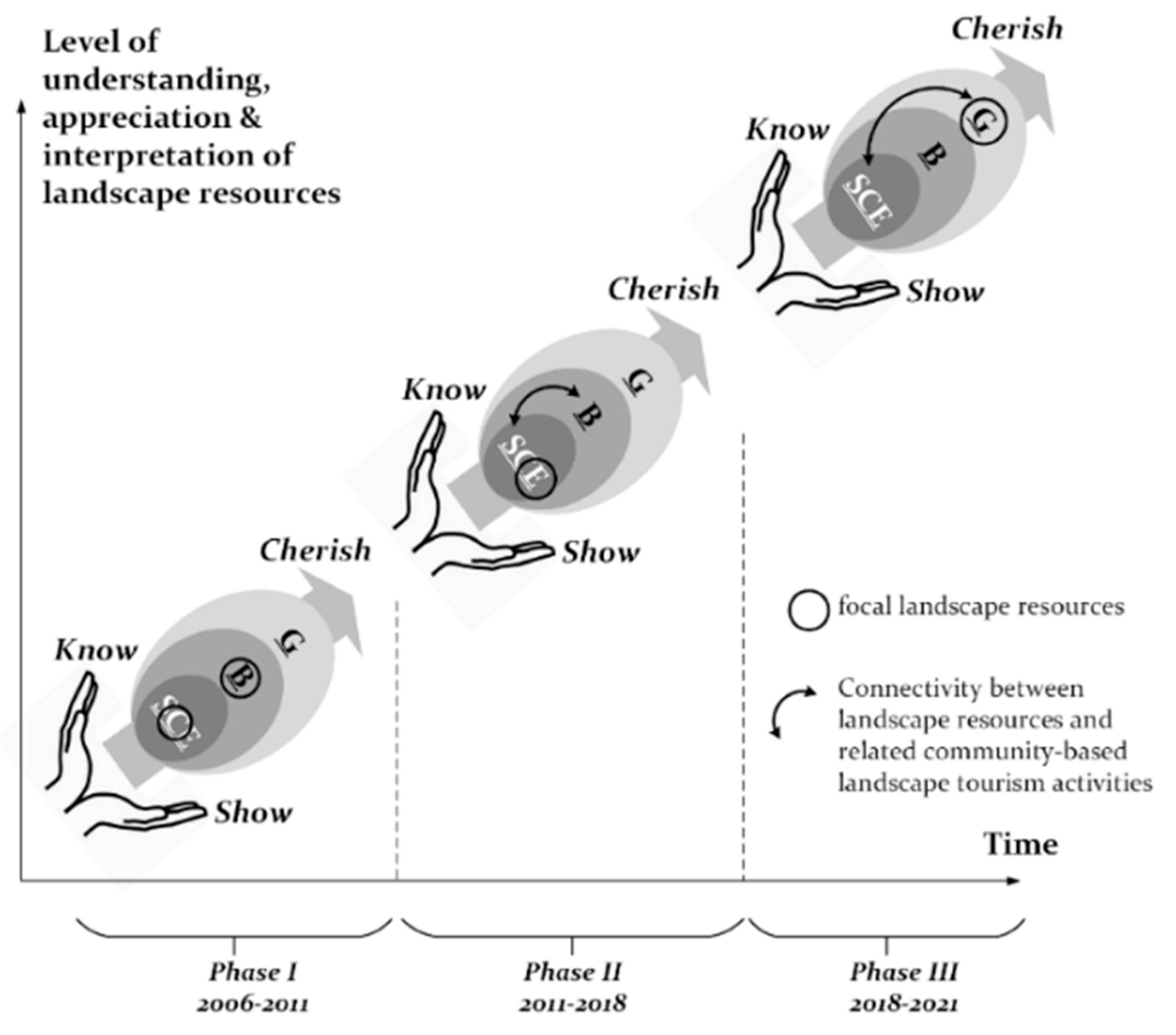
4.1. “Know–Cherish–Show–Cherish Even More” of the Landscape Resources

With its different variations, the “know–cherish–show” community-based landscape interpretation model has been applied through all three phases of integrated landscape management in Fengnan Village (Table 1). “Know” implied taking stock of the landscape resources (SCE, B, and G) at the beginning of each phase by the means of various community-based data-collection techniques (field surveys, interviews, workshops, PPGIS, and ecosystem services analysis). “Cherish” stood for the local people’s appreciation of the landscape resources (with an emphasis on G). “Show” entailed a series of community-based landscape interpretation and relevant capacity-building activities for the local people and stemmed from their level of understanding and appreciation of the landscape resources at a given point in time.
As an upward arrow in both Figure 3 (on a temporal scale) and Figure 4 (on a spatial scale), “cherish” is a central component of the model. Appreciation of landscape resources for their values or for the ecosystem services they provide [6,7,9] is a driving engine (motivation, inspiration) for community-based landscape tourism activities. The level of appreciation matures over time, along with a gradual accumulation of the local people’s landscape knowledge and their enhanced sense of place, belonging, and pride [4,8]. Furthermore, “cherish” transcends the boundaries of appreciation—from separate landscape components (C in SCE and B during Phase I) to the connectivity and interdependence between them (E in SCE + B during Phase II to G + SCE during Phase III). To indicate this “snowball” overlapping nature of the appreciation process, we may also name the model “know–cherish–show–cherish even more” (Figure 4).
Elaborating further on the “cherish” component, it is imperative to understand what it means for geoconservation and the development of community-based geotourism in the area. Our experience in Fengnan Village allowed us to observe that in a living nature–culture landscape with a distinctive geodiversity value, appreciation of geodiversity is intricately linked to other components of the landscape—its socio-cultural-economic diversity and biodiversity (Figure 4). In other words, geoconservation and the introduction of geotourism is not the singular or final goal of integrated landscape management in a coupled socio–cultural–biophysical system, but rather its integral and indispensable part.
Thus, for instance, during “the Turtle River Aspiring Geopark” Phase III (2018–2021), expert-local knowledge-driven capacity-building activities not only enriched the local community’s understanding of geodiversity, but also expanded the boundaries of their landscape vision to include the abiotic component (G) and interpret it through the lens of local livelihoods and culture. As a result, geodiversity was viewed as a “biophysical stage” where all other landscape elements could effectively perform, while geotourism became an intrinsic part of community-based landscape tourism.
We also note that the introduction of geoconservation and potential designation of a geopark within the setting of a living landscape is a gradual process rather than a straightforward enactment of institutional mechanisms. The Fengnan experience shows that even a unique geoconservation value of the area [31,32,33] and its high geopark potential did not imply its immediate official designation and launch of geotourism activities—15 years have passed and it is still an ongoing effort. In contrast, as the least understood and rather complex component of a living landscape (Figure 4), geodiversity (G) requires time for appreciation and “living it through” by both the primary and secondary stakeholders. It is a process of learning and becoming, instead of being already known and set in place.

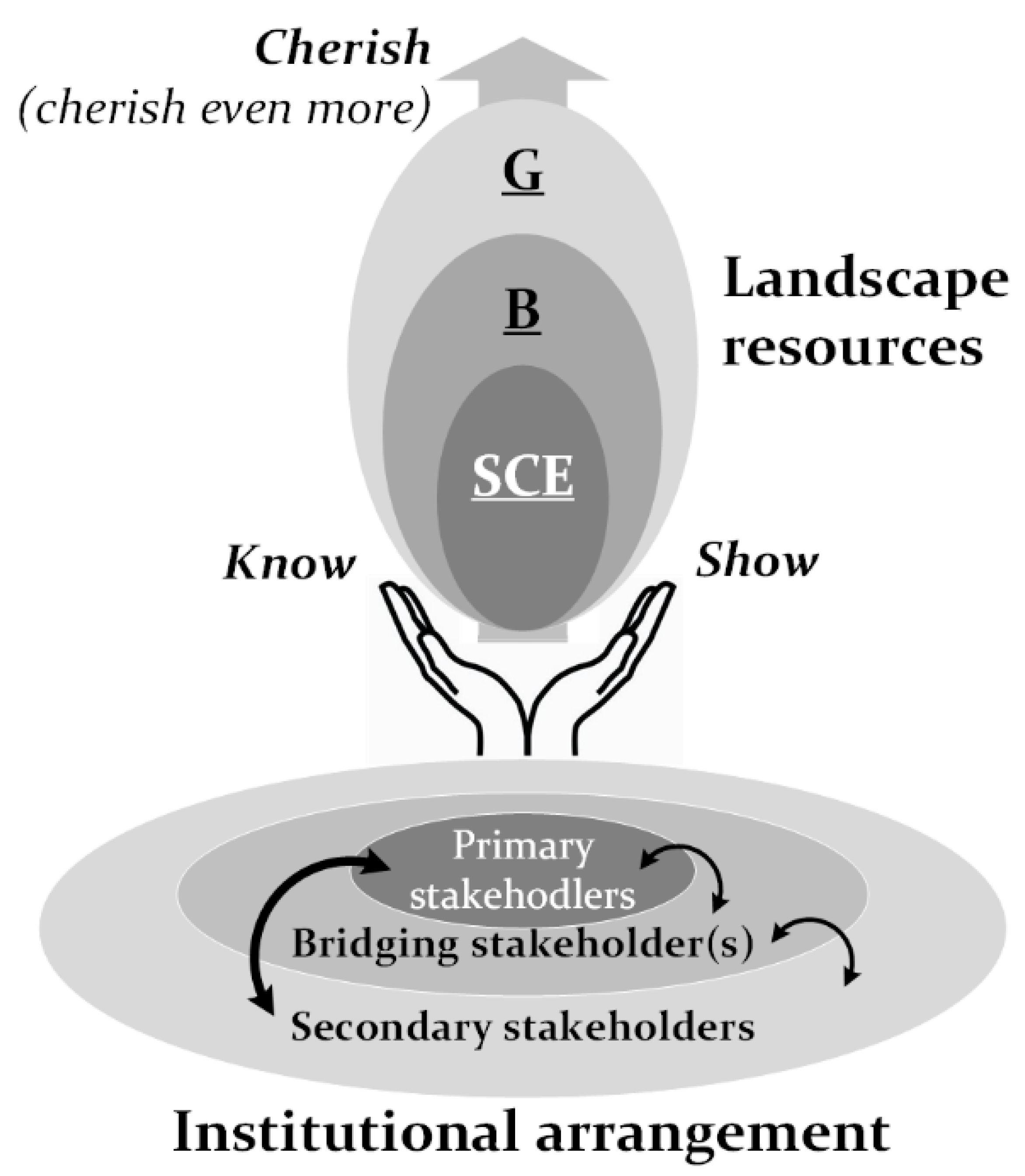
4.2. Institutional Arrangement for Integrated Landscape Management

The institutional arrangement for integrated landscape management in Fengnan Village implies collaborative planning and management processes between the local community (primary stakeholders) and government agencies (secondary stakeholders) with the facilitating role of NDHU (bridging stakeholder). In Figure 4, the institutional arrangement is conceptualized as a supporting sphere for the “know–cherish–show–cherish even more” model of landscape resources, while the interactions between the stakeholders are shown with arrows. Below, we discuss the role of each stakeholder type in the arrangement and the “local–local”, “local–governmental” and “multi-stakeholder” evolution of the institutional capacity over the years.

4.2.1. Primary Stakeholders

From the Fengnan Aspiring Cultural Landscape to the Turtle River Aspiring Geopark, the role of primary stakeholders and community participation has always been paramount. The composition of primary stakeholders has grown over the years (Table 1) from two in 2006 to ten in 2021, with a consistent engagement of the Fengnan Community Development Association. Community-based participatory planning and management is not only stipulated in CHPA (2005, 2016), but it is also the most fair and equitable way of prioritizing the interests and benefits of the local people [25,41,75].
In Section 3, Results, we demonstrated how community-based landscape tourism has matured over time to include cultural/rural, eco- and geotourism, with its operations currently being planned and implemented by the multi-stakeholder platform for collaborative governance of the Turtle River Aspiring Geopark. Here, we compare some take-away messages from our long-term on-the-ground involvement in Fengnan Village to several observations made in the literature.
First, we argue that community-based landscape interpretation including geo-interpretation in Fengnan Village is vastly different from the expert knowledge-dominated arrangements [12]. Instead of taking on a rather passive supporting role and allowing geology experts and professional tour guides to take the stage [8,10,16,23], Fengnan community members are the hosts of geotourism activities on their land. They are the ones who undergo the process of understanding, appreciating, and learning to interpret their landscape and their lived experiences within it. By processing and weaving the expert geo-knowledge with their own place-based TEK [75] and doing so at their own pace, the local people gradually develop their own geo-interpretation skills [73]. As Blackstock (2005) noted, community-based tourism should be a transformative experience for empowering primary stakeholders and not a functional one to solely serve the needs of the tourism industry [24].
Second, the Fengnan experience has shown that the “locally beneficial” principle of geotourism stretches far beyond purely economic benefits [13]. It is undoubtedly true that the initial motivation of the local people to partake in community-based tourism activities was driven by income-generating considerations [42,45]. Over time, however, its beneficial effects have become apparent across all aspects of local livelihoods: social cohesion, community leadership, mobilization capacity, self-esteem, sense of place, and belonging [8,24,25]. Comparable to Scheyvens’s [25,76] four dimensions of community empowerment (economic, psychological, social, and political), these benefits not only enhance the appreciation of landscape resources (“cherish even more”) but also safeguard the longevity of community-based tourism arrangement in the area.
Finally, with the diversity of backgrounds and experiences of its every individual, the local community may not be viewed as a homogeneous group [24]. Community-based activities implemented by several primary stakeholders do not imply that they are devoid of internal power struggles, conflicts of interest, or ideas. Disengagement of Yongfeng Primary School from cooperation with members of the Fengnan Community Development Association in late 2008 is one of such examples.
For this reason, establishment of multi-stakeholder platforms (e.g., between ten primary stakeholders working together during “the Turtle River Aspiring Geopark” Phase III) can have a far-reaching positive effect on the planning and management of large-scale community-based tourism activities. As Sayer et al. (2013) [21] and Denier et al. (2015) [22] pointed out, multi-stakeholder platforms placed at the core of integrated landscape management serve not only as a negotiation space for primary and secondary stakeholders but can also foster partnerships between two or several primary stakeholders.
It is not surprising that during the “Fengnan Aspiring Cultural Landscape” Phase I (2006–2011) emergence of “local–local” institutional capacity between the Fengnan Community Development Association and Yongfeng Primary School (though put on hold in 2009–2011) was seen as one of its main achievements. Working together on the inventory of landscape resources, developing place-based curriculum, and environmental interpretation activities was a critical first step toward building up social cohesion and partnership at the local level [36].

4.2.2. Secondary Stakeholders

Regional and central government agencies and, at a later phase, NGOs (including Taiwan Geoparks Association) are the secondary stakeholders who have been involved in integrated landscape management in Fengnan Village. Collaborative planning processes for the establishment of Cihalaay Cultural Landscape (Phase II, 2011–2018) paved the way for the emergence of the “local–governmental” institutional capacity. With Cihalaay being the first living cultural landscape designated in Taiwan (later followed by the Langdao Indigenous Cultural Landscape on the Orchid Island, 2013, and Wan’an Rice Paddy Cultural Landscape in Chihshang Township, Taitung County, 2014 [77,78]) it was a novel and challenging learning experience for both the local people and the government agencies [63]. The “local–governmental” partnership has since strengthened over the years and has served as an institutional foundation for the “Turtle River Aspiring Geopark” Phase III.
It is often assumed that capacity-building activities are for the primary stakeholders only. We observed, however, that the understanding and appreciation of landscape resources, and experiential and experimental learning [79] are processes equally applicable to the secondary stakeholders, but are often overlooked. In the Fengnan case, government stakeholders had at least two kinds of learning process to work through.
The first one was related to their exposure to several landscape concepts (cultural landscape, SEPL of the Satoyama Initiative, IUCN Category V Protected Landscape, and geopark), which were as new to them as they were to the local communities. However, in comparison to the local people’s openness to experiments, the government agencies had to first overcome their “institutional inertia”—an accustomed way of thinking and doing things. Understandably, a new concept, especially one that had never been implemented before, did entail a high degree of uncertainty and demanded some courage.
The second learning process meant working in partnership with the local communities and allowing community members to lead the way and set the rules as opposed to the customary top-down decision-making [80]. Constructing a dialogue with the local people was in some ways similar to being able to speak another language—the language of terms and categories comprehensible to the locals. It also encompassed substantial expert and TEK knowledge-weaving efforts.
It is the secondary stakeholders’ willingness and ability to engage in the above learning processes and the existence of suitable legal instruments (such as the 2005 and 2016 amendments to CHPA) that often determine the timeliness of introducing a new landscape concept to the area. Timeliness that includes the actual timing, spatial setting, and stakeholder composition may be dubbed as a favorable institutional climate.

4.2.3. Bridging Stakeholder(s)

Positioning of a bridging stakeholder in Figure 4 speaks for its bridging—facilitating, partnership-building—role in interactions between primary and secondary stakeholders. Throughout the three phases of integrated landscape management in Fengnan Village, this role has been performed by our team. Due to the observed lack of insider perspective on interactions between primary and secondary stakeholders in the existing geoconservation and community-based tourism literature [20], we see the need to contribute our experience to this part of the discussion.
Engagement techniques for land-use planning are considered among the most crucial yet the least understood areas of landscape-scale on-the-ground initiatives [81]. In the Fengnan case, our use of various landscape concepts and funding acquisition for relevant research projects from the government agencies had to be carefully analyzed in advance. Their timeliness had to reflect the current state of Fengnan’s coupled nature–culture system and address the interests of both primary and secondary stakeholders. Stakeholder willingness to engage and work with each other also required appropriate spatial conditions, which explains our adjustments to the case study area size over time: from Fengnan Village in 2006–2011 to the Cihalaay Tribe in 2011–2018 and back to Fengnan in 2018–2021.
Moreover, it was imperative to stay neutral to people and their actions and yet maintain a sufficient degree of sensitivity throughout the action research process. Taking on a pro-active role when required was just as important. The continuation of the community–university partnership of 2009–2011, even after Yongfeng Primary School had called a halt in a triangular arrangement, may be seen as an illustration of this principle. Sensitivity to shifts in the stakeholders’ interests and objectives can ensure their longevity of commitment and tackle this persistent challenge faced by many integrated landscape approaches [21,22].
In addition, in many instances, we had to function as a knowledge-bridging agent [75] between primary and secondary actors—between expert knowledge and TEK. Whether conducting capacity-building trainings on landscape interpretation for the local people or communicating their vision (e.g., results of ecosystem services analysis) to the government agencies, we were in the process of fostering a common language between multiple stakeholders.
Finally, as an academic bridging stakeholder, we had an opportunity to extrapolate the results of our study nationwide. In 2012, learning from our experience with the designation of the Cihalaay Cultural Landscape, we suggested a refined definition of cultural landscape to replace its rather vague CHPA 2005 version (see Section 2.2). After a series of negotiation processes, it was adopted by the Legislative Yuan and stipulated in the 2016 amendment to CHPA (Chapter 1, Article 3 (7)) as “locations or environments formed through long-time interactions between human beings and the natural environments, which are of value from the point of view of history, aesthetics, ethnology, or anthropology” [46]. This was an invaluable opportunity to align Taiwan’s cultural landscape definition with that of UNESCO [44].

5. Conclusions

In this study, we presented a structured overview of 15 years of integrated landscape management in Fengnan Village, Hualien County, Taiwan. Through community-based and multiple stakeholder-oriented emphasis of our action research, we have learned a number of invaluable lessons.
Our experience showed that geoconservation should be viewed as a holistic part of integrated landscape management in the context of connectivity between geodiversity and other nature–culture components of a living landscape. Furthermore, we noted that a community-based approach to geotourism implies a “lived through” understanding, appreciation, and interpretation of geodiversity by the local community as an inherent part of community-based landscape tourism. Capacity-building activities and bridging of local TEK and expert knowledge played a central role in empowering Fengnan locals as the hosts and geo-interpreters of their native landscape. Importantly, institutional arrangement between primary and secondary stakeholders have evolved over time and benefitted from facilitating efforts of the bridging stakeholder. Finally, a time-, space-, and stakeholder-sensitive introduction of relevant landscape concepts ensured trust and reciprocity in the long-term multi-stakeholder partnership.
We further lay out several challenges as we move forward. Fairness in the division of duties and responsibilities, benefit-sharing, and community cohesion in a diverse Fengnan community is a complex challenge at the local level. As a result of successful capacity-building activities of the three phases (2006–2021), today, the local people are fully competent to welcome tourists and carry out community-based geo-interpretation in the area. It is now essential, however, to consider the additional income generation options (e.g., geo-product development), equal participation, and sharing of geotourism profit between numerous organizations in Fengnan Village. The Turtle River Aspiring Geopark multi-stakeholder platform provides a much-needed opportunity for local negotiation and decision-making, while its long-term continuity should be carefully maintained.
The second potential challenge is related to the secondary stakeholder engagement. To date, HFDOFB has been the leading government agency supporting the Fengnan community’s efforts throughout the third phase (2018–2021). However, based on CHPA regulations, in the case of the future designation of the Turtle River Geopark, it is the local government—Hualien County government—that should be the main authority. Therefore, the sooner it becomes aware of and is involved in the ongoing geopark processes, the smoother the potential designation is likely to be.
The third challenge may be seen as a bridging stakeholder’s self-reminder note to ourselves. Fifteen years of continuous on-the-ground engagement in the same area and same community is a rarely seen phenomenon across action research case studies. The longevity of the partnership with the Fengnan community speaks for their level of approval and trust in us as the bridging stakeholder and in the local integrated landscape management processes. However, we need to be observant of the strengthening bottom-up capacity of the local people and their readiness to manage on their own. As we gradually let go of our facilitating role in the area, we may consider a consulting (mentoring) role based on the community’s vision and needs.
For future studies on community-based geoconservation and geotourism, we recommend enhanced insight into the interactions between geodiversity, biodiversity, and socio-cultural diversity within a landscape setting, on partnerships between various actors involved in geoconservation planning and management, and on the experiences of facilitating organizations (bridging stakeholders) from other areas around the world.

Author Contributions

Conceptualization, K.-C.L. and P.G.K.; Methodology, K.-C.L. and P.G.K.; Formal analysis, P.G.K.; Investigation, K.-C.L.; Resources, K.-C.L.; Data curation, P.G.K.; Writing—original draft preparation, P.G.K.; Writing—review and editing, K.-C.L.; Visualization, P.G.K. and K.-C.L.; Supervision, K.-C.L.; Project administration, K.-C.L.; Funding acquisition, K.-C.L. All authors have read and agreed to the published version of the manuscript.

Funding

At different stages, this research was funded by the Council of Cultural Affairs, the Hualien Cultural Affairs Bureau of the Council for Cultural Affairs, the Forestry Bureau (Council of Agriculture), the Hualien Forest District Office of the Forestry Bureau, the Ministry of Education, and the Institute for Global Environmental Strategies.

Institutional Review Board Statement

The study was conducted according to the guidelines of the Declaration of Helsinki and approved by the Institutional Review Boards of the funding agencies.

Informed Consent Statement

Informed consent was obtained from all subjects involved in the study.

Data Availability Statement

The data that support the findings of this study are available from the corresponding author upon reasonable request.

Acknowledgments

This research would not have been possible without the kind support and help of many individuals and organizations. We express our deep appreciation and gratitude to the funding agencies (see “Funding” section) and to the local people of Fengnan Village, Hualien County, Taiwan, who have kindly welcomed our efforts during this long-term partnership.

Conflicts of Interest

The authors declare no conflict of interest.

References

  1. United Nations Convention on Biological Diversity. Update of the Zero Draft of the Post-2020 Global Biodiversity Framework; United Nations Environment Programme: Nairobi, Kenya, 2020. [Google Scholar]
  2. Geodiversity, Geoheritage & Geoconservation. The ProGEO Simple Guide. 2017. Available online: http://www.progeo.ngo/publications.html (accessed on 15 July 2019).
  3. Crofts, R. Linking geoconservation with biodiversity conservation in protected areas. Int. J. Geoheritage Parks 2019, 7, 211–217. [Google Scholar] [CrossRef]
  4. Gray, M. Geodiversity: Valuing and Conserving Abiotic Nature, 2nd ed.; Wiley Blackwell: Chichester, UK, 2013. [Google Scholar]
  5. Farsani, N.T.; Coelho, C.; Costa, C. Geotourism and geoparks as novel strategies for socio-economic development in rural areas. Int. J. Tour. Res. 2011, 13, 68–81. [Google Scholar] [CrossRef]
  6. Gray, M.; Gordon, J.E.; Brown, E.J. Geodiversity and the ecosystem approach: The contribution of geoscience in delivering integrated environmental management. Proc. Geol. Assoc. 2013, 124, 659–673. [Google Scholar] [CrossRef]
  7. Alahuhta, J.; Ala-Hulkko, T.; Tukiainen, H.; Purola, L.; Akujarvi, A.; Lampinen, R.; Hjort, J. The role of geodiversity in providing ecosystem services at broad scales. Ecol. Indic. 2018, 91, 47–56. [Google Scholar] [CrossRef] [Green Version]
  8. Gordon, J.E. Geoheritage, geotourism and the cultural landscape: Enhancing the visitor experience and promoting geoconservation. Geosciences 2018, 8, 136. [Google Scholar] [CrossRef] [Green Version]
  9. Gray, M. Geodiversity: Valuing and Conserving Abiotic Nature, 1st ed.; John Wiley & Sons Ltd.: West Sussex, UK, 2004; pp. 65–131, 347–365. [Google Scholar]
  10. Dowling, R.; Newsome, D. Geotourism: A global activity. In Global Geotourism Perspectives; Dowling, R., Newsome, D., Eds.; Goodfellow Publishers Limited: Oxfordshire, UK, 2010; pp. 1–17. [Google Scholar]
  11. Hose, T.A. Selling the story of Britain’s stone. Environ. Interpret. 1995, 10, 16–17. [Google Scholar]
  12. Hose, T.A. European geotourism—Geological interpretation and geoconservation promotion for tourists. In Geological Heritage: Its Conservation and Management; Barrentino, D., Wimbledon, W.P., Gallego, E., Eds.; Instituto Technologico Geominero de Espana: Madrid, Spain, 2000; pp. 127–146. [Google Scholar]
  13. Newsome, D.; Dowling, R. Setting an agenda for geotourism. In Geotourism: The Tourism of Geology and Landscape, 1st ed.; Newsome, D., Dowling, R.K., Eds.; Goodfellow Publishers Limited: Oxfordshire, UK, 2010; pp. 1–12. [Google Scholar]
  14. National Geographic. Geotourism. Available online: https://www.nationalgeographic.com/maps/topic/geotourism (accessed on 2 June 2021).
  15. Brozinski, A. Centralized data management approaches in geotourism: A view from Finland. In Geotourism: The Tourism of Geology and Landscape, 1st ed.; Newsome, D., Dowling, R.K., Eds.; Goodfellow Publishers Limited: Oxfordshire, UK, 2010; pp. 46–60. [Google Scholar]
  16. Karkut, J. Reconsidering the boundaries and applications of geotourism—Lessons learnt from tourism at Mount Vesuvius. In Geotourism: The Tourism of Geology and Landscape, 1st ed.; Newsome, D., Dowling, R.K., Eds.; Goodfellow Publishers Limited: Oxfordshire, UK, 2010; pp. 88–99. [Google Scholar]
  17. Gu, H.; Subramanian, S.M. Drivers of change in socio-ecological production landscapes: Implications for better management. Ecol. Soc. 2014, 19, 41. [Google Scholar] [CrossRef]
  18. Liu, J.G.; Dietz, T.; Carpenter, S.R.; Alberti, M.; Folke, C.; Moran, E.; Pell, A.N.; Deadman, P.; Kratz, T.; Lubchenco, J.; et al. Complexity of coupled human and natural systems. Science 2007, 317, 1513–1516. [Google Scholar] [CrossRef] [PubMed] [Green Version]
  19. Crofts, R. Promoting geodiversity: Learning lessons from biodiversity. Proc. Geol. Assoc. 2014, 125, 263–266. [Google Scholar] [CrossRef]
  20. Ólafsdóttir, R.; Tverijonaite, E. Geotourism: A systematic literature review. Geosciences 2018, 8, 324. [Google Scholar] [CrossRef] [Green Version]
  21. Sayer, J.; Sunderland, T.; Ghazoul, J.; Pfund, J.-L.; Sheil, D. Ten principles for a landscape approach to reconciling agriculture, conservation, and other competing land uses. PNAS 2013, 110, 8349–8356. [Google Scholar] [CrossRef] [Green Version]
  22. Denier, L.; Scherr, S.; Shames, S.; Chatterton, P.; Hovani, L.; Stam, N. The Little Sustainable Landscapes Book; Global Canopy Programme: Oxford, UK, 2015. [Google Scholar]
  23. Newsome, D.; Dowling, R.; Leung, Y.F. The nature and management of geotourism: A case study of two established iconic geotourism destinations. Tour. Manag. Perspect. 2012, 2, 19–27. [Google Scholar] [CrossRef]
  24. Blackstock, K. A critical look at community-based tourism. Community Dev. J. 2005, 40, 39–49. [Google Scholar] [CrossRef]
  25. Dangi, T.B.; Jamal, T. An integrated approach to “sustainable community-based tourism”. Sustainability 2016, 8, 475. [Google Scholar] [CrossRef] [Green Version]
  26. Teng, L.S.; Lee, C.T.; Tsai, Y.B.; Hsiao, L.Y. Slab breakoff as a mechanism for flipping of subduction polarity in Taiwan. Geology 2000, 28, 155–158. [Google Scholar] [CrossRef]
  27. Hsieh, M.L.; Rau, R.J. Late Holocene coseismic uplift on the Huatung coast, eastern Taiwan: Evidence from mass mortality of intertidal organisms. Tectonophysics 2009, 474, 595–609. [Google Scholar] [CrossRef]
  28. Dadson, S.J.; Hovius, N.; Chen, H.; Dade, W.B.; Hsieh, M.L.; Willett, S.D.; Hu, J.C.; Horng, M.J.; Chen, M.C.; Stark, C.P.; et al. Links between erosion, runoff variability and seismicity in the Taiwan orogen. Nature 2003, 426, 648–651. [Google Scholar] [CrossRef] [PubMed]
  29. Lee, K.C. Ecosystem Services of the Central and Coastal Range Corridors to the Downstream Communities (3-3). Research Project Report Commissioned by the Hualien Forest District Office; Forestry Bureau: Taipei, Taiwan, 2019. (In Chinese)
  30. Chen, W.S. Lithofacies analysis of the arc-related sequence in Coastal Range, eastern Taiwan. J. Geol. Soc. China 1997, 40, 313–338. [Google Scholar]
  31. Lai, L.S.H.; Dorsey, R.J.; Hornd, C.S.; Chi, W.R.; Shea, K.S.; Yen, J.Y. Polygenetic melange in the retrowedge fore-deep of an active arc-continent collision, Coastal Range of eastern Taiwan. Sediment. Geol. 2021, 418, 105901. [Google Scholar] [CrossRef]
  32. Teng, L.S. Geotectonic evolution of late Cenozoic arc-continent collision in Taiwan. Tectonophysics 1990, 183, 57–76. [Google Scholar] [CrossRef]
  33. Gray, B.T. The Holocene Uplift of the Chihshang Segment of the Longitudinal Valley Fault at Fuli, Eastern Taiwan. Master’s Thesis, Central Washington University, Washington, DC, USA, August 2007. [Google Scholar]
  34. Lee, J.C.; Chu, H.T.; Angelier, J.; Hu, J.C.; Chen, H.Y.; Yu, S.B. Quantitative analysis of surface coseismic faulting and postseismic creep accompanying the 2003, Mw = 6.5, Chengkung earthquake in eastern Taiwan. J. Geophys. Res. Solid Earth 2006, 111, B02405. [Google Scholar] [CrossRef] [Green Version]
  35. Chen, W.S.; Huang, Y.C.; Liu, C.H.; Feng, H.T.; Chung, S.L.; Lee, Y.H. UPb zircon geochronology constraints on the ages of the Tananao Schist Belt and timing of orogenic events in Taiwan: Implications for a new tectonic evolution of the South China Block during the Mesozoic. Tectonophysics 2016, 686, 68–81. [Google Scholar] [CrossRef] [Green Version]
  36. Lee, K.C.; Chang, H.C.; Wang, S.; Chen, P.Z.; Wang, L.C.; Tsai, P.F. Community-based Participatory Approaches to Cultural Landscape Investigation in Hualien. In Proceedings of the 2nd Conference of Hualien Study, Cultural Affairs Bureau, Hualien, Taiwan, 25–26 October 2008; pp. 309–376. (In Chinese). [Google Scholar]
  37. Fuli Household Registration Office. Available online: https://fulihr.hl.gov.tw/ (accessed on 11 July 2021).
  38. Lee, K.C.; Hsu, T.; Chiang, S.Y.; Kacaw, L.; Lee, B.S. Conservation and management strategies for cultural landscapes: A case study of a continuing landscape in Taiwan. J. Cult. Herit. Conserv. 2016, 34, 66–92. (In Chinese) [Google Scholar]
  39. Nishi, M.; Yamazaki, M. Landscape approaches for the post-2020 biodiversity agenda: Perspectives from socio-ecological production landscapes and seascapes. UNU IAS Policy Brief. 2020, 21, 1–4. [Google Scholar]
  40. Usher, M.B. Earth science and the natural heritage: A synthesis. In Earth Science and the Natural Heritage; Gordon, J.E., Leys, K.F., Eds.; Stationery Office: Edinburgh, UK, 2001; pp. 315–324. [Google Scholar]
  41. O’Hare, D. Interpreting the cultural landscape for tourism development. Urban Des. Int. 1997, 2, 33–54. [Google Scholar] [CrossRef]
  42. Johnson, P.A. Realizing rural community-based development: Prospects for social-economy enterprises. J. Rural. Community Dev. 2010, 5, 150–162. [Google Scholar]
  43. Wood, M. Ecotourism Principles, Practices & Policies for Sustainability; United Nations Environment Programme: Paris, France, 2002. [Google Scholar]
  44. UNESCO. Cultural Landscapes. Available online: https://whc.unesco.org/en/culturallandscape/ (accessed on 1 June 2021).
  45. Walter, R.K.; Hamilton, R.J. A cultural landscape approach to community-based conservation in Solomon Islands. Ecol. Soc. 2014, 19. [Google Scholar] [CrossRef] [Green Version]
  46. Cultural Heritage Preservation Act. Laws and Legislations Database of the Republic of China. Available online: https://law.moj.gov.tw/ENG/LawClass/LawAll.aspx?pcode=H0170001 (accessed on 2 June 2021).
  47. International Partnership for the Satoyama Initiative (IPSI) Official Website. Available online: https://satoyama-initiative.org/ (accessed on 2 June 2021).
  48. Takeuchi, K.; Ichikawa, K.; Elmqvist, T. Satoyama landscape as social–Ecological system: Historical changes and future perspective. Curr. Opin. Environ. Sustain. 2016, 19, 30–39. [Google Scholar] [CrossRef]
  49. Calnan, R.; Brady, S.; Hill, W. Geoparks: Creating a Vision for North America. George Wright Forum 2009, 27, 40–45. [Google Scholar]
  50. Guthrie, G. Basic Research Methods: An Entry to Social Science Research; SAGE Publications: Thousand Oaks, CA, USA, 2010. [Google Scholar]
  51. Tilden, F. Interpreting Our Heritage, 3rd ed.; The University of North Carolina Press: Chapel Hill, NC, USA, 1977; pp. 3–10. [Google Scholar]
  52. Healey, P. Building institutional capacity through collaborative approaches to urban planning. Environ. Plan. 1998, 30, 1531–1546. [Google Scholar] [CrossRef]
  53. Healey, P. Collaborative Planning: Shaping Places in Fragmented Societies; Macmillan: London, UK, 2002. [Google Scholar]
  54. Silverman, D. Doing Qualitative Research—A Practical Handbook; Sage: London, UK, 2000. [Google Scholar]
  55. Laws, K.; McLeod, R. Case Study and Grounded Theory: Sharing Some Alternative Qualitative Research Methodologies with Systems Professionals. In Proceedings of the 22nd International Conference of the Systems Dynamics Society, Oxford, UK, 25–29 July 2004. [Google Scholar]
  56. Flowerdew, R.; Martin, D. (Eds.) Methods in Human Geography: A Guide for Students Doing Research Project; Longman: London, UK, 1997. [Google Scholar]
  57. Denscombe, M. The Good Research Guide: For Small-Scale Social Research Project; Open University Press: Buckingham, UK, 1998. [Google Scholar]
  58. Maxwell, J. Qualitative Research Design: An Interactive Approach; SAGE Publications: Thousand Oaks, CA, USA, 2013. [Google Scholar]
  59. Lee, K.C.; Wang, S. Incorporating Landscape Conservation into Taiwan’s National Protected Area System: A Community-Based Approach. In Proceedings of the Conference Abstracts of 5th International UNESCO Conference on Geoparks, Shimabara, Japan, 12–15 May 2012. [Google Scholar]
  60. Lee, K.C.; Kacaw, L.; Chen, M.L.; Shia, J.S.; Fan, M.L. Tailoring the Satoyama Initiative concepts to the national and local context: A case study of the collaborative planning process of a rice paddy cultural landscape in an indigenous community, Taiwan. In Mainstreaming Concepts and Approaches of Socio-Ecological Production Landscapes and Seascapes into Policy and Decision-Making (Satoyama Initiative Thematic Review Vol. 2); United Nations University Institute for the Advanced Study of Sustainability (UNU-IAS): Tokyo, Japan, 2016; pp. 50–58. [Google Scholar]
  61. Lee, K.C.; Fan, M.L.; Kacaw, L.; Yen, S.Y. Enhancing adaptive capacity of rural communities and landscape resilience to climate change. In Sustainable Development under Climate Change in Taiwan; Lin, C.C., Ed.; NTU Climate Change Center: Singapore, 2016; pp. 331–351. (In Chinese) [Google Scholar]
  62. Lee, K.C.; Wang, L.C.; Chen, Y.Y.; Lin, Y.Y.; Chen, G.Y. Development of a rural environmental education program in light of the Satoyama Initiative: A case study of the indigenous youth training course in Fengnan village, Hualien, Taiwan. J. Youth Stud. 2016, 19, 15–30. (In Chinese) [Google Scholar]
  63. Lee, K.C.; Yan, S.Y. Participatory planning and monitoring of protected landscapes: A case study of an indigenous rice paddy cultural landscape in Taiwan. Paddy Water Environ. 2019, 17, 539–548. [Google Scholar] [CrossRef]
  64. Lee, K.C. Weaving Traditional Ecological Knowledge into Indigenous Youth Education. In Culture and Environment: Weaving New Connections; Brill: Leiden, The Netherlands, 2019; pp. 425–443. [Google Scholar]
  65. Lee, K.C. Ecosystem Services of the Central and Coastal Range Corridors to the Downstream Communities (3-2). Research Project Report Commissioned by the Hualien Forest District Office; Forestry Bureau: Taipei, Taiwan, 2018. (In Chinese)
  66. Lee, K.C. Strategies of Enhancing Ecosystem Services of the Coastal Range Corridors to the Downstream Communities (2-1). Research Project Report Commissioned by the Hualien Forest District Office; Forestry Bureau: Taipei, Taiwan, 2020. (In Chinese)
  67. Lee, K.C.; Jian, J.Y.; Wang, L.C.; Karimova, P.G. Participatory Planning of Geotourism Interpretation for Rural Community Development in an Aspiring Geopark, Taiwan: An Ecosystem Services Framework. In Proceedings of the 10th International ProGEO Symposium: Building Connections for Global Geoconservation, Segovia, Spain, 7–10 June 2021; pp. 191–192. [Google Scholar]
  68. Dudley, N. Guidelines for Applying Protected Area Management Categories; IUCN: Gland, Switzerland, 2008. [Google Scholar]
  69. Phillips, A. Cultural landscapes: An IUCN perspective. In Cultural Landscapes of Universal Value: Components of a Global Strategy; von Droste, B., Plachter, H., Rössler, M., Fischer, G., Eds.; Spektrum Akademischer Verlag: Hedielberg, Germany, 1995; pp. 380–392. [Google Scholar]
  70. Phillips, A. Management Guidelines for IUCN Category V Protected Areas: Protected Landscapes/Seascapes; IUCN: Gland, Switzerland; Cambridge, UK, 2002. [Google Scholar]
  71. Elcome, S.; Baines, J. Steps to Success—Working with Residents and Neighbours to Develop and Implement Plans for Protected Areas; IUCN, Commission on Education and Communication/European Committee for Environmental Education: Gland, Switzerland, 1999. [Google Scholar]
  72. Lee, K.C.; Wang, S.; Ho, L.D.; Chang, S.C. A planning framework of community-based geoparks. Taiwan For. J. 2010, 36, 13–21. (In Chinese) [Google Scholar]
  73. Wang, L.C.; Lai, Y.H.; Jian, J.Y. Searching for Roots in the Mountain Valley: Guidebook for the Turtle River Aspiring Geopark; National Dong Hwa University: Hualien, Taiwan, 2021. (In Chinese) [Google Scholar]
  74. Taiwan Geoparks Network. Available online: http://140.112.64.54:88/ (accessed on 1 June 2021).
  75. Berkes, F. Evolution of co-management: Role of knowledge generation, bridging organisations and social learning. J. Environ. Manag. 2009, 90, 1692–1702. [Google Scholar] [CrossRef]
  76. Scheyvens, R. Tourism for Development: Empowering Communities; Prentice-Hall: London, UK, 2002. [Google Scholar]
  77. Ministry of Culture. Orchid Island. Available online: https://www.moc.gov.tw/en/information_130_75060.html (accessed on 1 June 2021).
  78. Chihshang Township Office. Available online: https://www.cs.gov.tw/home/index.php/travel/2019-05-29-07-19-03 (accessed on 1 June 2021).
  79. Leys, A.; Vanclay, J. Social learning: A knowledge and capacity-building approach for adaptive co-management of contested landscapes. Land Use Policy 2011, 28, 574–584. [Google Scholar] [CrossRef] [Green Version]
  80. Kawasaki, L. Community-based tourism: A pathway to sustainability for Japan’s protected areas. Soc. Nat. Resour. 2006, 19, 675–692. [Google Scholar]
  81. Glover, T.D.; Stewart, W.P.; Gladdys, K. Social ethics of landscape change: Toward community-based land-use planning. Qual. Inq. 2008, 14, 384–401. [Google Scholar] [CrossRef]

Short Biography of Authors

Dr. Kuang-Chung Lee: Professor and supervisor of the Landscape Conservation and Community Participation laboratory at the College of Environmental Studies, National Dong Hwa University (NDHU), Taiwan. He graduated from the Geography Department, National Taiwan University in 1989 and obtained his Ph.D. degree from the Geography Department of University College London in 2001. Dr. Kuang-Chung Lee previously worked for the Council of Agriculture and Taroko National Park, Taiwan. Since 2002, he has carried out about 40 research projects focused on community participation, natural and cultural landscape conservation, and collaborative planning and management of protected areas. He is currently a commission member of IUCN/WCPA, IUCN/CEC, ICOMOS, and ProGEO and is NDHU’s contact person at the International Partnership for the Satoyama Initiative.
Ms. Paulina G. Karimova: PhD Candidate and research assistant at the Landscape Conservation and Community Participation laboratory, College of Environmental Studies, National Dong Hwa University (NDHU), Taiwan. She obtained her Master of Environmental Science degree from the College of Environmental Studies, NDHU in 2018 and continued with her Ph.D. studies there. Paulina’s research interests include integrated landscape and seascape approaches, adaptive co-management in protected areas and socio-ecological production landscapes and seascapes, and community-based monitoring and evaluation. She is currently a commission member of IUCN/WCPA and ProGEO.
Figure 1. Fengnan Village as a coupled socio–cultural–biophysical system: (a) location of case study area; (b) upstream area of the Turtle River valley; (c) Cihalaay Cultural Landscape; (d) Small Tianxiang Gorge and the main settlement of Cilamitay Tribe along the middle reaches of the Turtle River terraces, meanders, and alluvial plains (source of b, c, d photos: Hualien Branch, Soil and Water Conservation Bureau, Council of Agriculture); (e) weekend community-based environmental education courses for Cilamitay Indigenous youth; (f) community-based landscape tourism activities.
Geosciences 11 00310 g001
Figure 2. Community-based landscape tourism within a coupled socio–cultural–biophysical system. IPLCs: Indigenous peoples and local communities.
Geosciences 11 00310 g002
Figure 3. Three phases of integrated landscape management for community-based landscape tourism in Fengnan Village, 2006–2021.
Geosciences 11 00310 g003
Figure 4. Landscape resources and institutional arrangement for integrated landscape management within a socio–cultural–biophysical system.
Geosciences 11 00310 g004
Table 1. Three phases of integrated landscape management for community-based landscape tourism in Fengnan Village, Hualien County, Taiwan (2006–2021).
PhasesPhase I: 2006–2011 Fengnan Aspiring Cultural LandscapePhase II: 2011–2018 Cihalaay Cultural LandscapePhase III: 2018–2021 Turtle River Aspiring Geopark
Sub-phasesParticipatory planning of community-based landscape tourism and place-based education for enhancing the cultural landscape awareness (2006–2008)University-community partnership for capacity-building of interpretation skills for community-based landscape tourism
(2009–2011)
Participatory planning, designation, management and monitoring of Cihalaay Cultural Landscape
(2011–2018)
Participatory planning of community-based geotourism and geo-interpretation activities for rural community development within the Turtle River Aspiring Geopark
(2018–2021)
Weekend community-based environmental education courses for Cilamitay Indigenous youth
(2012–2016)
Landscape concept appliedCultural landscape+ SEPL, the Satoyama Initiative
+ IUCN Category V Protected Landscape
Cultural landscape
+ Geopark
SEPL, the Satoyama Initiative
IUCN Category V Protected Landscape
Cultural landscape
Brief contentsExploring Fengnan cultural landscape potential: landscape resources inventory (interviews, field surveys, workshops), capacity-building (by NDHU 1) of landscape interpretation skills of the local people, teachers and students, development of a place-based curriculumLandscape resources inventory (field surveys, interviews, PPGIS 2), collaborative planning, official designation, management and monitoring of Cihalaay Cultural Landscape; conservation and sustainable use of Cihalaay SEPL 3; enhancing place-based education, community-based (from the elders to the youth) capacity-building of landscape interpretation skills Exploring Fengnan geopark potential: landscape resources inventory (field surveys, workshops, ecosystem services analysis), capacity-building of geo-interpretation skills (by NGOs and academia), collaborative planning of three core geodiversity areas, geotourism operations by multi-stakeholder platform
Stakeholders involvedPrimaryFengnan Community Development Association; Yongfeng Primary School Cihalaay Cultural Landscape Management Committee; Fengnan Community Development AssociationTen 4 local organizations from Fengnan Village
BridgingNDHUNDHUNDHU
SecondaryHFDOFB 5;
Ministry of Education; Council for Cultural Affairs (former Ministry of Culture) 6
Hualien Cultural Affairs Bureau;
HFDOFB
HFDOFB;
Ninth River Management Office 7;
other NGOs (incl. Geoparks Association of Taiwan)
“Know”: understanding of landscape resourcesHow?
Resources inventory tool
Interviews, field surveys, workshopsPPGIS, interviews, field surveys,
workshops
Field surveys, workshops, ecosystem services analysis
What?
Landscape resources
SCE 8: Cultural, production;
B: Ecological;
G: Scenic
SCE + B: Cultural, ecological and production values
SCE, G: Historical, representative and rarity values
SCE: Provisioning and cultural services
B: Provisioning, regulating and cultural services
G + SCE: Regulating, provisioning and cultural services
“Cherish”: appreciation of geodiversity among other landscape resourcesG?
Local perception of G
G: Scenic resourceG: Scenic resource, landscape background, source of drinking and irrigation water, and building materialG: Scenic resource, landscape background; regulating, provisioning and cultural services with connectivity to local livelihoods, local history and sense of place
“Show”: interpretation of landscape resourcesHow?
Capacity-building
Community-(school)-university partnership: capacity-building of landscape interpretation skills (scenic emphasis) of the local people, teachers and studentsCilamitay elders and youth: capacity-building of landscape interpretation skills of the local Indigenous youth; interpretation of SEPL’s cultural, ecological, and production valuesLocal-expert knowledge for Fengnan geotourism development: capacity-building of geo-interpretation skills of the local people with the help of relevant experts (NGOs and academia)
What?
Aspect of landscape tourism
Community-based cultural/rural (tribal) tourism, ecotourismCommunity-based cultural/rural (tribal, heritage and agricultural) tourism, ecotourism,
green products
Community-based landscape tourism with elements of cultural/rural (tribal, heritage and agricultural) tourism, ecotourism and geotourism
OutcomesLandscape resourcesInitial community-based understanding, appreciation and development of interpretation skills in relation to scenic value of Fengnan landscape resources and the connectivity between themEnhanced community-based understanding, appreciation and interpretation skills in relation to Cihalaay landscape resources with an emphasis on cultural, ecological and production values of SEPL as well as its conservation and sustainable useFurther enhanced community-based understanding, appreciation and interpretation skills in relation to landscape resources of the whole Fengnan Village with an emphasis on geodiversity value and its connectivity to socio-cultural-economic diversity
Institutional capacity“Local-local” institutional capacity: community and school“Local-governmental” institutional capacity: official collaboration with government agencies on protection of landscape resources in the name of Cihalaay Cultural Landscape (est. 2012)“Multi-stakeholder” institutional capacity: establishment of the multi-stakeholder platform between 10 primary and 15 secondary stakeholders for collaborative governance of the Turtle River Aspiring Geopark
Spatial scale (ha)Fengnan Village (3500 ha)Cihalaay Tribe (1000 ha)Fengnan Village (3500 ha)
Relevant publications [36][38,59,60,61,62,63,64][29,65,66,67]
Notes: 1 National Dong Hwa University (NDHU); 2 Public participation geographic information system (PPGIS); 3 Socio-ecological production landscape (SEPL); 4 Ten local organizations: Cilamitay Tribal Chief Committee, Fengnan Village Office, Fengnan Community Development Association, Cilamitay Tribal Meeting, Cilamitay Tribal Cultural Association, Fengnan Neighborhood Watch Team, Fengnan Drinking Water Committee, Fengnan Country Estate Homestay, Yongfeng Primary School, and Manna Rural Living Experimental Hub; 5 Hualien Forest District Office of the Forestry Bureau, Council of Agriculture, Executive Yuan (HFDOFB); 6 Limited involvement; 7 Ninth River Management Office, Water Resources Agency, Council of Economic Affairs, Executive Yuan; 8 SCE—socio-cultural and economic diversity, B—biodiversity, G—geodiversity (Figure 2).
Publisher’s Note: MDPI stays neutral with regard to jurisdictional claims in published maps and institutional affiliations.

