
Quantitative and Qualitative Analysis on the Integration of Geographic Information Systems and Building Information Modeling for the Generation and Management of 3D Models


 , and
, and
Abstract
:1. Introduction
2. Methodology
3. Step 1: Search for Information and Selection of the Most Relevant Contributions
3.1. Identification Stage
3.2. Screening Stage
3.3. Eligibility Stage
3.4. Inclusion Stage
4. Step 2: Bibliometric Analysis
4.1. Analysis by Type of Source
4.2. Analysis by Authors and Their Countries/Entities of Origin
5. Step 3: Identification of Key-Concept Cluster and Qualitative Analysis
- Building information modeling KCC. In this case, BIM is the central nucleus of integration (O: 828/TLS: 825, Figure 7), deriving within the area in other topics such as design, construction project management, and risk management (Figure 6). Likewise, it turns out to be the root for the generation of other important nodes such as, among others, information management, smart city, and digital twin, or even for the development of other KCCs themselves such as HBIM or information management, which shows the importance of BIM in the AEC industry.
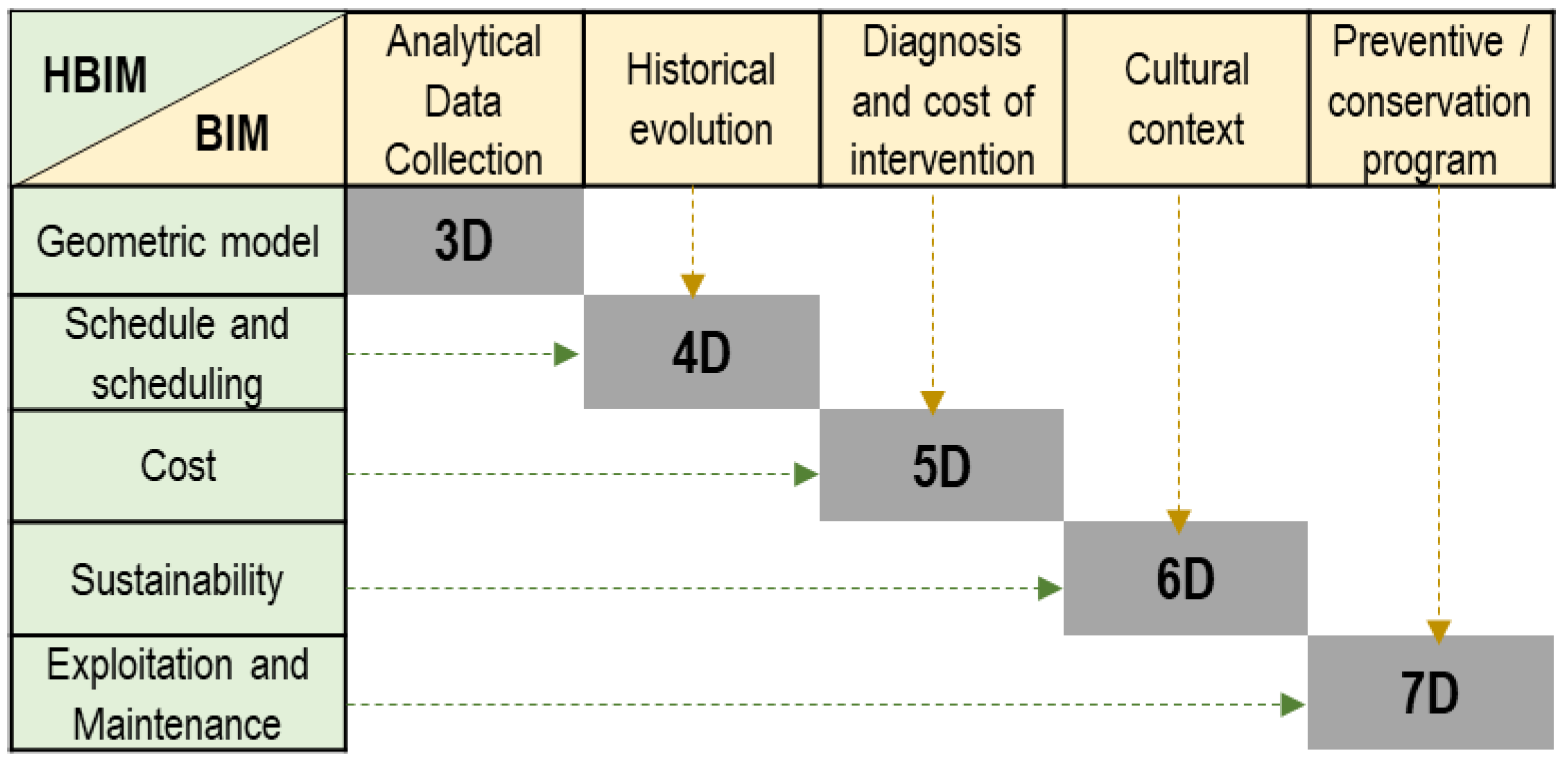
- Heritage building information modeling KCC. HBIM (O: 182/TLS: 164, Figure 7) constitutes the central node of the KCC, deriving in multiple relationships both intra-area and inter-area. Within the area, strong relationships are manifested with thematic nodes such as 3D models, preservation, restoration, cultural or architectural heritage, and others related to geometry, and the data generated through surveying activities.
- Geographic information systems KCC. GIS (O: 204/TLS: 204, Figure 7) constitutes the cornerstone of this area, generating multiple relationships both intra-area and inter-area. Within the area, it is related to nodes such as semantics, visualization and file formats (IFC/CityGML), interoperability and data integration, and urban planning. On the other hand, outside its area, the interconnection network, without becoming as dense as in the case of BIM, is appreciably larger than that of HBIM. Thus, the results show that GIS is essentially linked to integration and interoperability in smart city and digital twin models, having a very close relationship with the geometry and semantics of the HBIM model, energy efficiency, automation, design, project management and construction, and risk management.
- Life-cycle management KCC. Within this area there are applications oriented to sustainability and energy efficiency, cost analysis, quality control, smart buildings, and their automation.
- Information management KCC. In this regard, there are applications aimed at smart city, digital twin, internet of things (IoT), big data, virtual reality, or facility management.
6. GIS and BIM and HBIM Integration: Technical Progress and Possible Applications
6.1. Technical Progress
6.1.1. File Format
6.1.2. Geometry of the 3D Model and Its Semantics
6.1.3. Data Generated by Surveying Activities
6.1.4. Applicability of the Model under the Concept of Smart City
7. SWOT Analysis
8. Conclusions
Author Contributions
Funding
Institutional Review Board Statement
Informed Consent Statement
Data Availability Statement
Conflicts of Interest
Abbreviations
| AEC | Architecture Engineering and Construction |
| BIM | Building Information Modeling |
| CityGML | City Geography Markup Language |
| GIS | Geographic Information System |
| GNIpc | Gross National Income per capital |
| HBIM | Heritage Building Information Modeling |
| HDI | Human Development Index |
| IFC | Industry Foundation Classes |
| KCC | key-Concept Cluster |
| LOD | Levels of Detail//Levels of Development |
| LOK | Levels of Knowledge |
| OGC | Open Geospatial Consortium |
| PRISMA | Preferred Reporting Items for Systematic reviews and Meta-Analyses |
| PTLoE | Population-Tertiary Level of Education |
| SWOT | Strengths, Weaknesses, Opportunities, and Threats |
| TLS | Total Link Strength |
| XML | eXtensible Markup Language |
References
- Hijazi, I.H.; Krauth, T.; Donaubauer, A.; Kolbe., T. 3D CITY DB4 BIM: A system architecture for linking bim server and 3d citydb for bim-gis-integration. In ISPRS Annals of the Photogrammetry, Remote Sensing and Spatial Information Sciences; Copernicus GmbH: Göttingen, Germany, 2020; Volume 5, pp. 195–202. [Google Scholar] [CrossRef]
- Abd, A.M.; Hameed, A.H.; Nsaif, B.M. Documentation of construction project using integration of BIM and GIS technique. Asian J. Civ. Eng. 2020, 21, 1249–1257. [Google Scholar] [CrossRef]
- Hwang, J.R.; Kang, H.Y.; Hong, C.H. A Study on the Platform Design for Efficient Interoperability of BIM and GIS. J. Korea Spat. Inf. Soc. 2012, 20, 99–107. [Google Scholar] [CrossRef] [Green Version]
- El-Mekawy, M.; Östman, A.; Hijazi, I. A unified building model for 3D urban GIS. ISPRS Int. J. Geo-Inf. 2012, 1, 120–145. [Google Scholar] [CrossRef] [Green Version]
- Del Giudice, M.; Osello, A.; Patti, E. BIM and GIS for district modeling. In EWork and EBusiness in Architecture, Engineering and Construction, Proceedings of the 10th European Conference on Product and Process Modelling, ECPPM 2014, Vienna, Austria, 17–19 September 2014; CRC Press/Balkema: Boca Raton, FL, USA, 2015; pp. 851–854. [Google Scholar] [CrossRef]
- Dou, S.Q.; Zhang, H.H.; Zhao, Y.Q.; Wang, A.M.; Xiong, Y.T.; Zuo, J.M. Research on Construction of Spatio-Temporal Data Visualization Platform for Gis And BIM Fusion. In International Archives of the Photogrammetry, Remote Sensing and Spatial Information Sciences—ISPRS Archives; International Society for Photogrammetry and Remote Sensing: Guilin, China, 2020; Volume 42, pp. 555–563. [Google Scholar] [CrossRef] [Green Version]
- Wang, X.; Wang, J.; Wu, C.; Xu, S.; Ma, W.; Wang, X.; Wang, J.; Wu, C.; Xu, S.; Ma, W. Engineering Brain: Metaverse for future engineering. AI Civ. Eng. 2022, 1, 1–18. [Google Scholar] [CrossRef]
- Lee, J.H.; Ostwald, M.J.; Gu, N. Design Thinking and Building Information Modelling. In Design Thinking: Creativity, Collaboration and Culture; Springer: Cham, Switzerland, 2020; pp. 147–163. [Google Scholar] [CrossRef]
- Goyal, L.K.; Chauhan, R.; Kumar, R.; Rai, H.S. Use of BIM in Development of Smart Cities: A Review. In IOP Conference Series: Materials Science and Engineering; IOP Publishing Ltd.: Bristol, UK, 2020; Volume 955. [Google Scholar] [CrossRef]
- Dore, C.; Murphy, M. Integration of Historic Building Information Modeling (HBIM) and 3D GIS for recording and managing cultural heritage sites. In Proceedings of the 2012 18th International Conference on Virtual Systems and Multimedia; VSMM 2012: Virtual Systems in the Information Society, Milan, Italy, 2–5 September 2012; UNESCO: Paris, France, 2012; pp. 369–376. [Google Scholar] [CrossRef]
- Quattrini, R.; Pierdicca, R.; Morbidoni, C. Knowledge-based data enrichment for HBIM: Exploring high-quality models using the semantic-web. J. Cult. Herit. 2017, 28, 129–139. [Google Scholar] [CrossRef]
- Bruno, S.; De Fino, M.; Fatiguso, F. Historic Building Information Modelling: Performance assessment for diagnosis-aided information modelling and management. Autom. Constr. 2018, 86, 256–276. [Google Scholar] [CrossRef]
- Mol, A.; Cabaleiro, M.; Sousa, H.S.; Branco, J.M. HBIM for storing life-cycle data regarding decay and damage in existing timber structures. Autom. Constr. 2020, 117, 103262. [Google Scholar] [CrossRef]
- Yin, X.; Liu, H.; Chen, Y.; Al-Hussein, M. Building information modelling for off-site construction: Review and future directions. Autom. Constr. 2019, 101, 72–91. [Google Scholar] [CrossRef]
- Tejaswini, V.; Kesava Rao, P.; Jaya Shankar, G.; Nagaraja, R.; Sinha, S.K. A Comparative Study on Various Stages of Level of Details in Advanced 3D Building Construction Using BIM Tools. IOP Conf. Ser. Mater. Sci. Eng. 2020, 1006, 012012. [Google Scholar] [CrossRef]
- Castellano-Román, M.; Pinto-Puerto, F. Dimensions and Levels of Knowledge in Heritage Building Information Modelling, HBIM: The model of the Charterhouse of Jerez (Cádiz, Spain). Digit. Appl. Archaeol. Cult. Herit. 2019, 14, e00110. [Google Scholar] [CrossRef]
- Murphy, M.; Mcgovern, E.; Pavia, S. Historic building information modelling (HBIM). Struct. Surv. 2009, 27, 311–327. [Google Scholar] [CrossRef] [Green Version]
- Palomar, I.J.; García Valldecabres, J.L.; Tzortzopoulos, P.; Pellicer, E. An online platform to unify and synchronise heritage architecture information. Autom. Constr. 2020, 110, 103008. [Google Scholar] [CrossRef]
- Xia, H.; Liu, Z.; Efremochkina, M.; Liu, X.; Lin, C. Study on city digital twin technologies for sustainable smart city design: A review and bibliometric analysis of geographic information system and building information modeling integration. Sustain. Cities Soc. 2022, 84, 104009. [Google Scholar] [CrossRef]
- Song, Y.; Wang, X.; Tan, Y.; Wu, P.; Cheng, J.C.P.; Hampson, K. Trends and opportunities of BIM-GIS integration in the architecture, engineering and construction industry: A review from a spatio-temporal statistical perspective. ISPRS Int. J. Geo-Inf. 2017, 6, 397. [Google Scholar] [CrossRef]
- Zhang, H.; Tang, R.; Qiu, J.; Qiu, X. Design and Implementation of GIS+BIM-Based Digital Campus System. In Proceedings of the 2019 International Conference on Artificial Intelligence and Advanced Manufacturing, AIAM 2019, Dublin, Ireland, 16–18 October 2019; Institute of Electrical and Electronics Engineers Inc.: Piscataway, NJ, USA, 2019; pp. 329–335. [Google Scholar] [CrossRef]
- Kadhim, N. BIM And GIS Data Integration for The Evaluation of Building Performance. Int. Arch. Photogramm. Remote Sens. Spat. Inf. Sci—ISPRS Arch. 2022, 46, 135–139. [Google Scholar] [CrossRef]
- Przybyla, J. The Next Frontier for BIM: Interoperability with GIS; National Institute of Building Sciences: Washington, DC, USA, 2010. [Google Scholar]
- Sholeh, M.N.; Nurdiana, A.; Setiabudi, B.; Suharjono. Identification of Potential Uses of Building Information Modeling (BIM) for Construction Supply Chain Management: Preliminary Studies. IOP Conf. Ser. Earth Environ. Sci. 2020, 448, 012064. [Google Scholar] [CrossRef]
- Baik, A.; Yaagoubi, R.; Boehm, J. Integration of jeddah historical bim and 3D GIS for documentation and restoration of historical monument. In International Archives of the Photogrammetry, Remote Sensing and Spatial Information Sciences; ISPRS Archives; International Society for Photogrammetry and Remote Sensing: Taipei, Taiwan, 2015; Volume 40, pp. 29–34. [Google Scholar] [CrossRef] [Green Version]
- Yang, X.; Grussenmeyer, P.; Koehl, M.; Macher, H.; Murtiyoso, A.; Landes, T. Review of built heritage modelling: Integration of HBIM and other information techniques. J. Cult. Herit. 2020, 46, 350–360. [Google Scholar] [CrossRef]
- Arcuri, N.; De Ruggiero, M.; Salvo, F.; Zinno, R. Automated valuation methods through the cost approach in a BIM and GIS integration framework for smart city appraisals. Sustainability 2020, 12, 7546. [Google Scholar] [CrossRef]
- Moher, D.; Liberati, A.; Tetzlaff, J.; Altman, D.G. Preferred reporting items for systematic reviews and meta-analyses: The PRISMA statement. PLoS Med. 2009, 6, e1000097. [Google Scholar] [CrossRef] [Green Version]
- Antwi-Afari, M.F.; Li, H.; Pärn, E.A.; Edwards, D.J. Critical success factors for implementing building information modelling (BIM): A longitudinal review. Autom. Constr. 2018, 91, 100–110. [Google Scholar] [CrossRef]
- Aria, M.; Cuccurullo, C. App to Bibliometric Analysis of Scientific Production “Bibliometrix”. 2016. Available online: https://www.bibliometrix.org/Biblioshiny.html (accessed on 20 January 2021).
- Programme UND. 2020_Latest Human Development Index Ranking. 2020. Available online: http://hdr.undp.org/en/content/latest-human-development-index-ranking (accessed on 17 May 2021).
- Estadística IV de Índice de Desarrollo Humano por Indicadores Según Países_2020. 2020. Available online: https://www.eustat.eus/elementos/ele0013500/ti_indice-de-desarrollo-humano-por-indicadores-segun-paises-2019/tbl0013566_c.html (accessed on 17 May 2021).
- Banco Mundial. Población, Total 1960–2019. 2020. Available online: https://datos.bancomundial.org/indicator/SP.POP.TOTL (accessed on 17 May 2021).
- Development O for EC and Educational attainment of 25–64 year-olds (2019). 2020. Available online: https://www.oecd-ilibrary.org/education/educational-attainment-of-25-64-year-olds-2019_75230926-en (accessed on 17 May 2021).
- Wen, Q.J.; Ren, Z.J.; Lu, H.; Wu, J.F. The progress and trend of BIM research: A bibliometrics-based visualization analysis. Autom. Constr. 2021, 124, 103558. [Google Scholar] [CrossRef]
- Noardo, F.; Harrie, L.; Ohori, K.A.; Biljecki, F.; Ellul, C.; Krijnen, T.; Eriksson, H.; Guler, D.; Hintz, D.; Jadidi, M.; et al. Tools for BIM-GIS integration (IFC georeferencing and conversions): Results from the GeoBIM benchmark 2019. ISPRS Int. J. Geo-Inf. 2020, 9, 502. [Google Scholar] [CrossRef]
- Sharkawi, K.H.; Abdul-Rahman, A. Improving semantic updating method on 3D city models using hybrid semantic-geometric 3D segmentation technique. In ISPRS Annals of the Photogrammetry, Remote Sensing and Spatial Information Sciences; Copernicus GmbH: Göttingen, Germany, 2013; Volume 2, pp. 261–268. [Google Scholar] [CrossRef] [Green Version]
- Open Geospatial Consortium. 1994. Available online: https://www.ogc.org/standards/citygml (accessed on 10 January 2021).
- Ren, S.; Mao, J.; Ye, L.; Liu, X. 3D building modeling and indoor fire event representation in CityGML. Appl. Mech. Mater. 2012, 166–169, 2631–2636. [Google Scholar] [CrossRef]
- Buyuksalih, I.; Isikdag, U.; Zlatanova, S. Exploring the processes of generating LOD (0-2) CityGML models in greater municipality of Istanbul. In International Archives of the Photogrammetry, Remote Sensing and Spatial Information Sciences—ISPRS Archives; International Society for Photogrammetry and Remote Sensing: Istanbul, Turkey, 2013; Volume XL-2/W2, pp. 19–24. [Google Scholar] [CrossRef] [Green Version]
- Andrianesi, D.E.; Dimopoulou, E. An Integrated BIM-GIS Platform for Representing and Visualizing 3D Cadastral Data. In ISPRS Annals of the Photogrammetry, Remote Sensing and Spatial Information Sciences; Copernicus GmbH: Göttingen, Germany, 2020; Volume 6, pp. 3–11. [Google Scholar] [CrossRef]
- Fan, H.; Mao, B.; Shen, J.; Meng, L. Shell model representation as a substitute of LoD3 for 3D modeling in CityGML. In Proceedings of the Joint ISPRS Workshop on 3D City Modelling and Applications and the 6th 3D GeoInfo, 3DCMA 2011, Wuhan, China, 26–28 June 2011; pp. 79–84. [Google Scholar] [CrossRef]
- Popovic, D.; Govedarica, M.; Jovanovic, D.; Radulovic, A.; Simeunovic, V. 3D Visualization of Urban Area Using Lidar Technology and CityGML. In IOP Conference Series: Earth and Environmental Science; Institute of Physics Publishing: Bristol, UK, 2017; Volume 95. [Google Scholar] [CrossRef]
- Donkers, S.; Ledoux, H.; Zhao, J.; Stoter, J. Automatic conversion of IFC datasets to geometrically and semantically correct CityGML LOD3 buildings. Trans. GIS 2016, 20, 547–569. [Google Scholar] [CrossRef] [Green Version]
- Boje, C.; Guerriero, A.; Kubicki, S.; Rezgui, Y. Towards a semantic Construction Digital Twin: Directions for future research. Autom. Constr. 2020, 114, 103179. [Google Scholar] [CrossRef]
- Fan, H.; Meng, L. A three-step approach of simplifying 3D buildings modeled by cityGML. Int. J. Geogr. Inf. Sci. 2012, 26, 1091–1107. [Google Scholar] [CrossRef]
- Hämäläinen, M. Smart City Development with Digital Twin Technology. 2020. Available online: https://www.researchgate.net/publication/350460052_Smart_city_based_on_digital_twins (accessed on 17 September 2021).
- Döllner, J.; Hagedorn, B. Integrating urban GIS, CAD, and BIM data by service-based virtual 3D city models. In Urban and Regional Data Management—UDMS Annual 2007; CRC Press: Boca Raton, FL, USA, 2008; pp. 157–170. [Google Scholar]
- Lee, A.; Kim, J.; Jang, I. Movable Dynamic Data Detection and Visualization for Digital Twin City. In Proceedings of the International Conference on Consumer Electronics-Asia (ICCE-Asia), Seoul, Korea, 1–3 November 2020; Institute of Electrical and Electronics Engineers: Piscataway, NJ, USA, 2020. INSPEC Accession Number: 20257668. [Google Scholar] [CrossRef]
- Grieves, M. Digital Twin: Manufacturing Excellence through Virtual Factory Replication. 2015. Available online: https://www.3ds.com/fileadmin/Products-Services/Delmia/Pdf/Whitepaper/DELMIA-APRISO-Digital-Twin-Whitepaper.pdf (accessed on 25 October 2021).
- White, G.; Zink, A.; Codecá, L.; Clarke, S. A digital twin smart city for citizen feedback. Cities 2021, 110, 103064. [Google Scholar] [CrossRef]
- Cambridge GIS. Model GIS City of Cambridge/Citywide 3D Model. 1999. Available online: https://www.cambridgema.gov/GIS/3D/citywide3dmodel (accessed on 7 December 2020).
- Helsinki. Helsingin Kaupunki. 2015. Available online: https://www.hel.fi/helsinki/en/administration/information/general/3d/view/view-the-models (accessed on 5 December 2020).
- National Research Foundation. Virtual Singapore. 2018. Available online: https://www.nrf.gov.sg/programmes/virtual-singapore (accessed on 26 May 2021).
- Universidad de Cambridge. Center for Digital Built Britain. 2017. Available online: https://www.cdbb.cam.ac.uk/ (accessed on 20 January 2021).
- Redondo, F.J.M.; Menéndez, L.V.; Álvarez, A.R.; Fernández, A.A.; Fernández-Jardón, B.G. Plataforma virtual para el diseño, planificación, control, intervención y mantenimiento en el ámbito de la conservación del patrimonio histórico ‘Petrobim. Rehabend 2016, 2016, 1374–1382. [Google Scholar]
- Kassem, M.; Kelly, G.; Dawood, N.; Serginson, M.; Lockley, S. BIM in facilities management applications: A case study of a large university complex. Built. Environ. Proj. Asset. Manag. 2015, 5, 261–277. [Google Scholar] [CrossRef] [Green Version]
- Trisyanti, S.W.; Suwardhi, D.; Murtiyoso, A.; Grussenmeyer, P. Low-cost web-application for management of 3D digital building and complex based on BIM and GIS. In International Archives of the Photogrammetry, Remote Sensing and Spatial Information Sciences—ISPRS Archives; International Society for Photogrammetry and Remote Sensing: Istanbul, Turkey, 2019; Volume 42, pp. 371–375. [Google Scholar] [CrossRef] [Green Version]
- Lin, Y.-C.; Cheung, W.-F. Developing WSN/BIM-Based Environmental Monitoring Management System for Parking Garages in Smart Cities. J. Manag. Eng. 2020, 36, 04020012. [Google Scholar] [CrossRef]
- Amirebrahimi, S.; Rajabifard, A.; Mendis, P.; Ngo, T. A BIM-GIS integration method in support of the assessment and 3D visualisation of flood damage to a building. J. Spat. Sci. 2016, 61, 317–350. [Google Scholar] [CrossRef]
- Park, E.S.; Seo, H.C. Risk analysis for earthquake-damaged buildings using point cloud and bim data: A case study of the Daeseong apartment complex in Pohang, South Korea. Sustainability 2021, 13, 456. [Google Scholar] [CrossRef]
- Ma, G.; Tan, S.; Shang, S. The evaluation of building fire emergency response capability based on the CMM. Int. J. Environ. Res. Public Health 2019, 16, 1962. [Google Scholar] [CrossRef] [PubMed] [Green Version]
- Liu, Z.; Zhang, A.; Wang, W. A framework for an indoor safety management system based on digital twin. Sensors 2020, 20, 5771. [Google Scholar] [CrossRef] [PubMed]
- Lyu, H.M.; Wang, G.F.; Shen, J.S.; Lu, L.H.; Wang, G.Q. Analysis and GIS mapping of flooding hazards on 10 May 2016, Guangzhou, China. Water 2016, 8, 447. [Google Scholar] [CrossRef] [Green Version]
- Bao, L.X.; Wang, Y.Q. Research on expressway network tolling platform technology based on GIS+BIM. In Smart Innovation, Systems and Technologies; Springer: Berlin/Heidelberg, Germany, 2019; Volume 127, pp. 241–250. [Google Scholar] [CrossRef]
- Akob, Z.; Abang Hipni, M.Z.; Abd Razak, A. Deployment of GIS + BIM in the construction of Pan Borneo Highway Sarawak, Malaysia. In IOP Conference Series: Materials Science and Engineering; Institute of Physics Publishing: Bristol, UK, 2019; Volume 512. [Google Scholar] [CrossRef]
- Demir, K.; Ergen, B.; Ergen, Z.; Çabuk, S. Diseño 3D colaborativo con el método BDMUD: Efectos de un edificio en reflexiones de paisaje urbano en planificacion urbana. Archit. City Environ. 2016, 11, 61–80. [Google Scholar] [CrossRef] [Green Version]
- Wei, J.; Chen, G.; Huang, J.; Xu, L.; Yang, Y.; Wang, J.; Sadick, A.; Wei, J.; Chen, G.; Huang, J.; et al. BIM and GIS Applications in Bridge Projects: A Critical Review. Appl. Sci. 2021, 11, 6207. [Google Scholar] [CrossRef]
- Han, Z.H.; Wang, Z.K.; Gao, C.; Wang, M.X.; Li, S.T. Application of GIS and BIM Integration Technology in Construction Management. In IOP Conference Series: Earth and Environmental Science; Institute of Physics Publishing: Bristol, UK, 2020; Volume 526. [Google Scholar] [CrossRef]
- Dall’O’, G.; Zichi, A.; Torri, M. Green BIM and CIM: Sustainable Planning Using Building Information Modelling. In Research for Development; Springer: Berlin/Heidelberg, Germany, 2020; pp. 383–409. [Google Scholar] [CrossRef]
- Zaballos, A.; Briones, A.; Massa, A.; Centelles, P.; Caballero, V. A smart campus’ digital twin for sustainable comfort monitoring. Sustainability 2020, 12, 9196. [Google Scholar] [CrossRef]
- Eleftheriadis, S.; Mumovic, D.; Greening, P. Life cycle energy efficiency in building structures: A review of current developments and future outlooks based on BIM capabilities. Renew. Sustain. Energy Rev. 2017, 67, 811–825. [Google Scholar] [CrossRef] [Green Version]
- Fernández, R. MSI Estudio: Cuáles son los Principales Softwares BIM Para la Gestión del Facility Management. 2019. Available online: https://www.msistudio.com/cuales-son-los-principales-softwares-bim-para-la-gestion-del-facility-management/ (accessed on 12 January 2021).
- Van Eldik, M.A.; Vahdatikhaki, F.; Dos Santos, J.M.O.; Visser, M.; Doree, A. BIM-based environmental impact assessment for infrastructure design projects. Autom. Constr. 2020, 120, 103379. [Google Scholar] [CrossRef]
- Delval, T.; Geffroy, B.; Rezoug, M.; Jolibois, A.; Oliveira, F.; Carré, S.; Tual, M.; Soula, J. BIM to Develop Integrated, Incremental and Multiscale Methods to Assess Comfort and Quality of Public Spaces. In Lecture Notes in Civil Engineering; Springer: Berlin/Heidelberg, Germany, 2021; Volume 98, pp. 160–179. [Google Scholar] [CrossRef]
- Zhu, C.; Zheng, L.; Liu, Y.; Li, R.; Zhang, Z.; Xie, Y.; Feng, J. The application of bim technology in landscape garden engineering projects. In Advances in Intelligent Systems and Computing; Springer: Berlin/Heidelberg, Germany, 2021; Volume 1244, pp. 550–556. [Google Scholar] [CrossRef]
- Dutt, F.; Quan, S.J.; Woodworth, E.; Castro-Lacouture, D.; Stuart, B.J.; Yang, P.P.J. Modeling algae powered neighborhood through GIS and BIM integration. In Energy Procedia; Elsevier Ltd.: Amsterdam, The Netherlands, 2017; Volume 105, pp. 3830–3836. [Google Scholar] [CrossRef]
- Yamamura, S.; Fan, L.; Suzuki, Y. Assessment of Urban Energy Performance through Integration of BIM and GIS for Smart City Planning. In Procedia Engineering; Elsevier Ltd.: Amsterdam, The Netherlands, 2017; Volume 180, pp. 1462–1472. [Google Scholar] [CrossRef]
- Ge, L.; Xiong, Y. Interaction and application of bim technology in urban rail transit design phase. In ICTE 2019—Proceedings of the 6th International Conference on Transportation Engineering; American Society of Civil Engineers (ASCE): Reston, VI, USA, 2019; pp. 95–100. [Google Scholar] [CrossRef]
- Kardinal Jusuf, S.; Mousseau, B.; Godfroid, G.; Soh Jin Hui, V. Integrated modeling of CityGML and IFC for city/neighborhood development for urban microclimates analysis. In Energy Procedia; Elsevier Ltd.: Amsterdam, The Netherlands, 2017; Volume 122, pp. 145–150. [Google Scholar] [CrossRef]
- Wang, T.; Krijnen, T.; De Vries, B. Combining GIS and BIM for facility reuse: A profiling approach. Res. Urban Ser. 2016, 4, 185–203. [Google Scholar] [CrossRef]
- Cecchini, C.; Magrini, A.; Gobbi, L. A 3d platform for energy data visualization of building assets. In IOP Conference Series: Earth and Environmental Science; Institute of Physics Publishing: Bristol, UK, 2019; Volume 296. [Google Scholar] [CrossRef]
- Wetter, M.; Van Treeck, C.; Helsen, L.; Maccarini, A.; Saelens, D.; Robinson, D.; Schweiger, G. IBPSA Project 1: BIM/GIS and Modelica framework for building and community energy system design and operation—Ongoing developments, lessons learned and challenges. In IOP Conference Series: Earth and Environmental Science; Institute of Physics Publishing: Bristol, UK, 2019; Volume 323. [Google Scholar] [CrossRef]
- O’Donnell, J.; Truong-Hong, L.; Boyle, N.; Corry, E.; Cao, J.; Laefer, D.F. LiDAR point-cloud mapping of building façades for building energy performance simulation. Autom. Constr. 2019, 107, 102905. [Google Scholar] [CrossRef]
- Lei, Y.; Rao, Y.; Wu, J.; Lin, C.H. BIM based cyber-physical systems for intelligent disaster prevention. J. Ind. Inf. Integr. 2020, 20, 100171. [Google Scholar] [CrossRef]
- Cui, B.; Wen, X.; Zhang, D. The application of intelligent emergency response system for urban underground space disasters based on 3D GIS, BIM and internet of things. In ACM International Conference Proceeding Series; Association for Computing Machinery: New York, NY, USA, 2019; pp. 745–749. [Google Scholar] [CrossRef]
- Rong, Y.; Zhang, T.; Zheng, Y.; Hu, C.; Peng, L.; Feng, P. Three-dimensional urban flood inundation simulation based on digital aerial photogrammetry. J. Hydrol. 2020, 584, 124308. [Google Scholar] [CrossRef]


| Theme | Document Type | |
|---|---|---|
| Articles (Journals/Congresses) | Other Sources | |
| BIM | 24,826 | 863 |
| HBIM | 742 | 36 |
| GIS & BIM & HBIM | 677 | 38 |
| Total | 26,245 | 937 |
| Subject Area | BIM | HBIM | GIS & BIM & HBIM |
|---|---|---|---|
| Engineering | 34.92% | 20.34% | 30.66% |
| Computer Science | 29.00% | 29.33% | 21.01% |
| Environmental Science | 7.66% | 11.01% | 12.09% |
| Social Sciences | 8.33% | 22.92% | 15.95% |
| Earth and Planetary Sciences | 8.06% | 10.67% | 12.44% |
| Materials Science | 3.73% | 3.93% | 2.40% |
| Energy | 4.31% | 1.80% | 5.49% |
| BIM | HBIM | GIS & BIM & HBIM | |||||||
|---|---|---|---|---|---|---|---|---|---|
| Journal | Congress | Others | Journal | Congress | Others | Journal | Congress | Others | |
| No. contributions | 9459 | 9688 | 766 | 215 | 348 | 48 | 225 | 372 | 28 |
| % Articles | 8948 (94.60%) | 9118 (94.12%) | 203 (94.40%) | 318 (91.40%) | 212 (94.20%) | 320 (86.00%) | |||
| % Review | 511 (5.40%) | 557 (5.88%) | 12 (5.60%) | 30 (8.60%) | 13 (5.80%) | 52 (14.00%) | |||
| Countries with More than 15 Papers | Papers by Country | Entities with Most Papers |
|---|---|---|
| China | 166 | Chinese Ministry of Education (8) The University of Hong Kong (8) |
| Italy | 54 | Politécnico di Torino (10) Politécnico di Milano (10) Università degli Studi di Brescia (5) |
| UK | 54 | University College London (13) |
| Germany | 48 | Technical University of Munich (11) Karlsruhe Institute of Technology (7) Bauhaus-Universität Weimar (6) |
| United States | 45 | Pennsylvania State University (4) Georgia Institute of Technology (4) |
| Hong Kong | 56 | University of Hong Kong (11) Hong Kong University of Science and Technology (9) |
| Australia | 22 | University of Melbourne (9) Curtin University (5) Australasia Joint Research Center for Building Information Modeling (4) |
| Canada | 22 | University of Toronto (4) York University (4) |
| Russia | 22 | Moscow State University of Civil Engineering (9) |
| The Netherlands | 21 | Delft University of Technology (15) Technische Universiteit Eindhoven (4) |
| Strenghts | |||
|---|---|---|---|
| Heritage Conservation | Cost and Quality Control |
Construction Project | Life Cycle Analysis |
| Manage semantic knowledge information | Reduce costs [43] | Synchronize design and planning [29] | Evaluate model changes over time [13] |
| Be able to contain geometric or semantic information [26,40] | Improving product quality and optimizing management [51] | Simulate the environment surrounding the project and its reactions [57] | Plan the maintenance and renewal of assets |
| Modeling quantitative and qualitative information [29] | Managing risk and safety [58,59,60,61,62,63] | Manage all project information | Simplify and reduce the time to obtain and update information |
| Integrate and digitally manage heritage | Improve productivity [64,65] | Enable the process to be more dynamic and efficient [13] | Analyze decision making [7] |
| Automating performance evaluation and heritage conservation | Save time | Plan the project according to its local environment, and not only at the level of the uniqueness of a building | Analyze buildings throughout their life cycle, considering the surrounding environment [63] |
| Optimize the dissemination of heritage | Planning decision making [64] | Virtual building management [62] | |
| Improving risk management | Manage construction [60] | Facilitate monitoring processes | |
| Facilities Management | Sustainability and Energy Efficiency | Interoperability and Semantics | Urban and Transport Planning |
| Predicting maintenance through simulation [26,52] | Integrally improving urban sustainability [20] | Automate the production of 3D digital documentation | Facilitating the improvement of public services |
| Optimize, through HBIM, the management and maintenance of historic buildings | Planning and managing the sustainability of cities [66,67] | Sharing and exchange of information between BIM and geospatial objects [68] | Improved 3D visualization and use of virtual reality (VR) and augmented reality (AR) [6,29] |
| Organize in a 3D environment the information generated throughout the design and construction process [69] | Reducing the time required for environmental impact assessment of projects [70,71,72] | Enabling extended communication between stakeholders to manage a common data environment | Create digital simulation models that are updated based on their physical counterparts [73] |
| Managing public spaces [74,75] | Designing smart neighborhoods in an ecological and efficient way [76,77,78,79,80] | Sharing of information, knowledge and communications among all stakeholders [9] | Enabling simulation of urban phenomena or designs based on a real city |
| Infrastructure maintenance [75] | Perform urban microclimate analysis [76] | Integrating IoT | Integrating machine learning and artificial intelligence |
| Monitoring systems through 3D simulation | Reducing construction and demolition waste (CDW) [77] | Accessing and updating information | Enable exploration and analysis of the management tasks in a city [41] |
| Inventorying large-scale equipment | Designing community energy systems [81,82,83,84] | Predicting trends | Smart city management and human trafficking within them |
| Calculate demand and large-scale production | Forecast energy costs of the building/city | Visualize and compare on a large scale the project and finishes of your materials | Simulation of natural disasters and intelligent response systems in urban disasters [81,82,85] |
| Weaknesses | |||
| Heritage Conservation | Cost and Quality Control | Construction Project | Life-Cycle Analisis |
| Uncertainty when dealing with historical buildings | Specialized professional training of employees is required | High cost of implementation of GIS/BIM technology in company [84] | Require a well-fed model |
| Uniqueness of the components of the heritage asset | 3D model management is an arduous and continuous task over time | Difficulty to supply the model with the information generated during the construction process | Unfeasibility of many projects due to IoT requirements |
| Limited historical, semantic and graphic information | Customers are reluctant to pay the high cost of managing the model | Require very powerful hardware for integrated project modeling | Failure to upgrade CMMS (computerized maintenance management system/software) systems to 3D formats |
| Absence of life cycle information | Lack of clarity in the legal framework for BIM technology | Lack of free licenses for model integration | Lack of financial resources on the part of the public administration to generate and manage these models |
| High cost of data capture | High maintenance cost of an integrated quality management system | Lack of information management orientation of the model | High cost of updating the BIM model throughout the life cycle [43] |
| Facilities Management | Sustainability and Energy Efficiency | Interoperability and Semantics | Urban and Transport Planning |
| Requirement to manage and use complex and disparate data [43] | Lack of semantic information for the creation and management of the energy model | Limitation in representing the semantics of the models in different platforms | Insufficient sensor technology to create a smart city |
| Lack or insufficiency of information for Facility Management | Models very far from reality | Incompatibility between models | Lack or absence of quality LIDAR data available in public administrations |
| Losing information between construction and operation phases | Restriction of access to user energy consumption information | Requirement for constant software upgrades by stakeholders | Extremely high cost of data acquisition to generate the model |
| BIM software is not designed to perform Facility Management | Few urban-scale 3D models are at the LoD4 as-built level of development | Poor stakeholder training in interoperability and coding concepts | Preference of the public administration to finance 2D GIS models, due to their lower cost, in relation to 3D GIS |
| Difficulty in data transmission for bidirectional integration with management software | Low level of development of energy efficiency software at the macro-urban level | Lack of all BIM model information in the IFC models | High number of working hours in the elaboration of an adequate city model |
| Incompatibility between models | Lack of sensor technology for the management of as-built models | There is no universal platform [84] | Errors in the actual representation of the model [84] |
| Opportunities | |||
| Heritage Conservation | Cost and Quality Control | Construction Project | Life-Cycle Analisis |
| Take the opportunity to virtualize the management/visit heritage assets through digital models as a consequence of certain risks (for example, pandemics) | Globally widespread standardization to facilitate collaboration and data integration [11] | The availability of BIM methods and routes for the implementation of digitization of buildings and structures [14] | The growing interest in passing management CMMS 2D to 3D |
| High number of historic buildings in need of intervention [18] | Optimization in 3D visualization of production cycle control | The existing need for information exchange and cooperative work at a global development level [13] | The need for access to asset information through a 3D virtual library |
| The need for easy access to historical and heritage information | The use of simulation as a tool for reducing maintenance costs | The need for effective building management | Constant development of monitoring technology |
| The extensive development in virtual and augmented reality for representing heritage | The need to remotely manage and supervise the production process | The requirement to optimize design time | The requirement of public entities in transparent and collaborative management |
| Overall interest in managing and preserving historic buildings | Need to optimize the bidding process for the project | The growing need for remote asset management | |
| Facilities Management | Sustainability and Energy Efficiency | Interoperability and Semantics | Urban and Transport Planning |
| The need to optimize digital asset management | The need for an integrated element to facilitate sustainability and efficiency improvements | Requirements to improve risk sharing among stakeholders [86] | The possibility of 3D representation in disaster management |
| The need to optimize the Computerized Maintenance Management Systems/Software (CMMS) | The availability of solar incidence simulation tools at city scale | The need of stakeholders to increase the capacity to face rapid technological change in the AEC sector [87] | The development of new technologies and the use of the smartphones for the interrelation of the user and the city |
| Improved accessibility of high-capacity Internet services | Global requirements to promote energy control and resource savings | The existing need to improve trust among stakeholders [86] | The creation of regulations to motivate the use of BIM models in structures and public buildings |
| Potential development of applicable sensorics | The need for tools for global and comparative 3D statistical control of energy expenditure | The wide range of software and plug-ins | GIS and BIM and HBIM will be increasingly in demand in urban planning/regeneration |
| Threats | |||
| Heritage Conservation | Cost and Quality Control | Construction Project | Life-Cycle Analisis |
| Reliance on laser scanning for the capture of certain data | Few professionals with training and accreditation in BIM supervision | Unwillingness of contractors, clients and users to employ digital BIM modeling [84] | High cost of implementation of a BIM system for life cycle management |
| Loss of historical information due to inadequate management | Increased project cost, due to quality control with BIM | Lack of customers requesting the digital 3D service because of its price | Non-availability of historical information on structures and their maintenance |
| Lack of interest in disseminating heritage | Difficult accessibility and expensive 3D quality control equipment. | The resources required are expensive | High cost of sensor technology required for monitoring during operation/intervention phase |
| Need for significant investments [86] | Lack of idiosyncrasy to promote monitoring and control of the project with 3D models | Lack of regulatory requirements for the development of private projects in BIM | Requirement for highly qualified human resources for remote monitoring of assets |
| Facilities Management | Sustainability and Energy Efficiency | Interoperability and Semantics | Urban and Transport Planning |
| Lack of resources for 3D modeling of installations | Lack of initiative on the part of technicians to switch to the use of 3D software for energy calculations | High cost of software | Lack of initiative on the part of public administrations to transform their 2D GIS to 3D. |
| 3D models are usually architectural. | Deficiency in the characterization of materials in historic buildings | High cost of software [87] | Representation in LoD 3 and LoD 4 still very expensive |
| The high cost of software licenses CMMS | The reduced practice of sustainable design in many countries | Lack of standardization [86] | Lack of requirements from authorities to submit regeneration/urban planning proposals in GIS and BIM and HBIM |
| Incompatibility of 2D and 3D model connection formats | Difficult relationship between stakeholders | Stakeholder limitations in programming language training | |
Publisher’s Note: MDPI stays neutral with regard to jurisdictional claims in published maps and institutional affiliations. |
© 2022 by the authors. Licensee MDPI, Basel, Switzerland. This article is an open access article distributed under the terms and conditions of the Creative Commons Attribution (CC BY) license (https://creativecommons.org/licenses/by/4.0/).
Share and Cite
Carrasco, C.A.; Lombillo, I.; Sánchez-Espeso, J.M.; Balbás, F.J. Quantitative and Qualitative Analysis on the Integration of Geographic Information Systems and Building Information Modeling for the Generation and Management of 3D Models. Buildings 2022, 12, 1672. https://doi.org/10.3390/buildings12101672
Carrasco CA, Lombillo I, Sánchez-Espeso JM, Balbás FJ. Quantitative and Qualitative Analysis on the Integration of Geographic Information Systems and Building Information Modeling for the Generation and Management of 3D Models. Buildings. 2022; 12(10):1672. https://doi.org/10.3390/buildings12101672
Chicago/Turabian StyleCarrasco, César A., Ignacio Lombillo, Javier M. Sánchez-Espeso, and Francisco Javier Balbás. 2022. "Quantitative and Qualitative Analysis on the Integration of Geographic Information Systems and Building Information Modeling for the Generation and Management of 3D Models" Buildings 12, no. 10: 1672. https://doi.org/10.3390/buildings12101672