1. Introduction
Facing screaming injustices of land ownership as a result of Apartheid ideology and legislation, Southern African countries need to address demands of their landless poor and their black majorities, not least because liberation movements have fostered the access to land as one of the key aspects of independence and majority rule [
1]. The former settler colonies Namibia, South Africa and Zimbabwe have chosen different approaches to land reform in order to redress these imbalances [
2]: While Namibia and South Africa adhere to moderate, market-based approaches to land redistribution, Zimbabwe’s land reform may be viewed as one of the most radical and comprehensive examples in recent world history [
3].
From its inception, land reform in Zimbabwe has attracted extensive and ongoing attention among scholars in a number of disciplines. Research has taken place within different institutions by authors with divergent backgrounds who utilized differing methodologies, and were focused on a variety of study areas, topics, and time periods. Results, conclusions and interpretations of these studies vary widely. Scoones
et al. have concluded that bias and misinformation are common in this debate [
4], despite the tireless efforts of prominent authors such as Moyo, who has published on Zimbabwe’s land reform for more than twenty years [
5]. The lack of comparable datasets acquired through objective quantitative methods is prevalent in the debate and “
poverty of data lead to a poverty of understanding” as Scoones concluded in his contribution “
Dodgy Data and Measures: Why Good Numbers Matter” [
6]. Because of the inherent political character of Zimbabwe’s land reform program, its different waves are exposed to an intense scientific debate concerning their success. Recently, authors—notably Scoones
et al. [
4] and Matondi [
7]—have moved away from simply characterizing the reform process as either an utter failure or a complete success and as either right or wrong [
4]. Instead, focus has been placed on outcomes of the major economic and social reorganization ongoing in Zimbabwe exemplified by the special edition of the Journal of Peasant Studies: “Outcomes of the Post-2000 Fast Track Land Reform in Zimbabwe” [
8]. Another example is Mutopos’s analysis on gender in resettled livelihoods, which shows increased local agricultural production on land previously considered unfavorable. Therefore, her work can be seen as an example of how data can overcome narratives [
9]. Currently, however, an objective and standardized spatial research framework does not exist which characterizes the land redistribution efforts in the whole country from independence in 1980 until today.
In this article, we attempt to highlight the contemporary status and potential of geographical research on Zimbabwe’s land reform. Through the introduction of an innovative research framework, we aim to overcome highlighted shortcomings of the debate. After outlining the land question in Zimbabwe and the government’s countermeasures in
Section 2, we elaborate on the need of traceable land reform assessment frameworks (
Section 3). Subsequently, we put the focus on different aspects of research and document the lack of geospatial methods applicable to the research on land reform in
Section 4. By presenting regional examples of remote sensing analysis in the region (
Section 5) and the concept of participatory web-mapping (
Section 6)
, we illustrate the potential of both methods for the research on Zimbabwe’s land reform before we present a research framework which would add spatial and objective input to the research on land reform (
Section 7). Finally, we conclude in
Section 8 that the elaborated methods of geomatics can address important questions of land reform research.
2. Zimbabwe’s Multifarious Land Reform
Land has always been a contentious issue in Southern Africa, from the early recorded history of the region until today. The movement of native Africans to the Southern tip of the continent [
10], the expansion of European logistic settlements [
11], the extensive form of local agriculture and the hunt for mineral deposits [
12] have all been important factors in provoking demand for and conflict over land in emerging territories and colonies in the region. Following the establishment of independent states with white minority rule, access to productive land was restricted by public law [
13]. In the former Rhodesia, approximately 50% of the agricultural land was held by 6100 settler families, while the majority of the country’s 7,000,000 people lived within the other half [
14]. Among various others, the call for an even distribution of productive land was an important factor for liberation movements and independence fighters to back their support from a large proportion of the region’s population. In 1994, Murray and Williams asserted that the call for land redistribution in the region can “…
only be understood in the context of the history of conquest and dispossession, of territorial segregation and political exclusion, of generations of state control of the movement of people and the socio-economic conditions of their lives” [
15].
As a reflection of its critical importance, land was an immediate issue following the founding of the independent nation of Zimbabwe in 1980 [
16]. After independence, the newly elected government started to implement the national land reform program which is documented in the
Lancaster House Agreement, a result of the preceding independence negotiations of the British Government, the Zimbabwe Rhodesia Government and the political and military alliances ZANU (Zimbabwe African Peoples Union), Patriotic Front and ZAPU (Zimbabwe African National Union) [
17]. As the former colonial power in Rhodesia, the United Kingdom provided foreign currency support to compensate expropriated farmers for their farms, which were usually purchased in an open market through a state preemption process.
Palmer, writing in 1990, provided a useful history of land reform in Zimbabwe during the 1980–1990 period [
17]. He describes initial land reform efforts in Zimbabwe as proceeding relatively swiftly and successfully [
17]. A period of quiet regarding land reform followed this initial process. By the late 1980s, however, land reform had become less efficient and successful. Many of the farms purchased by the government in the initial phase of land reform were easily acquired as they had been left abandoned by their former owners following independence. Transfer of land then became more complex and costly. In addition, the nation entered a period of economic recession, further complicating land reform. The Zimbabwean government also contributed to the perception of a failed land reform by subsequently developing increasingly ambitious and unachievable land redistribution goals. As Palmer emphasizes, the number of households to be resettled by the government was increased nine-fold in the first two years of independence. The slow and costly “
willing buyer—willing seller” approach along with the limitations of compulsory acquisition led to disappointing results as the governmental institutions could not achieve their ambitious land reform goals [
17].
The
Land Acquisition Act was revised in the early 1990’s. While the revised act empowered the government to involuntarily expropriate operating farmlands (with appropriate compensation), this did not accelerate the land reform process [
18]. The number of resettled households continued to decline each year between 1995 and 2000. When the market-based redistribution approach slowed further, land acquisition strategies changed. In the year 2000 a process called
jambanja began. In a more spontaneous than planned fashion, poor rural residents started occupying farms and evicting the white owners. This practice was supported by a shift of executive power from state organs to group movements that ignored respective court rulings which judged the process as unlawful.
Jambanja can be translated as “
violence” or “
angry argument”. The term cannot be characterized easily and should, according to Chaumba
et al., be understood as a combination of top-down influences, including efforts of
Zimbabwe African National Union—Patriotic Front (ZANU-PF) cadres to maintain power; individual interests and communal desire for land, compensation and righteousness [
19]. Besides a number of possible reasons, some observers have linked the initiation of farm evictions with the loss of support for the ZANU-PF and President Robert Mugabe [
20], but also cite the increasing resistance of white farmers to a constitutional election [
21]. Mr. Mugabe and his government had to defend their stand in the debate on the constitutional referendum in parliamentary elections 2000 and in presidential elections in 2002. Along with growing opposition among the
Movement of Democratic Change (MDC), a lack of popular support became obvious. The constitutional referendum, which included the legalization of uncompensated farm expropriation, was defeated [
19,
22].
After the defeat of the constitutional election, large numbers of people (notably including war veterans) began moving on to white owned farms. This process was seen by ZANU-PF as a way to mobilize support for its authority as well as for the land reform program [
23]. A new set of legal definitions, included in new evictions acts and other legal amendments, followed this uncoordinated process and turned the new
de facto ownership into
de jure ownership. Through a new ambitious spatial planning process which took place during 2000 and 2001 (but did not meet specific preset goals), the disorder of
jambanja was turned into an official governmental policy called the “
Fast Track Land Reform Programme” (FTLRP) of Zimbabwe [
19].
Redistributed farms in Zimbabwe were split and categorized according to a dualistic scheme which has its roots partly within the agricultural planning from around 1950 [
4]. “
A1” farms were designed as smallholder farms, while “
A2” farms comprised larger small scale commercial farms. Other models such as a model “
D” for pastoral use were also defined, but were not applied in practice [
17]. Common grazing and settlement areas were allocated to some “
A1” farms which were then referred to as “
villagised” models. For “
self-contained A1” model on the other hand a complete segmentation of an entire agricultural area into individually owned plots took place [
24].
Considering Zimbabwe’s land ownership history in terms of time, space, participants, aims and strategies, it is understandable that the FTLRP is subject to heated public, scientific and political debate. Obtaining reliable socioeconomic, demographic and environmental data relevant to the history and ongoing events involved in the Zimbabwean land reform process is problematic. This makes arriving at an overall judgment regarding the abrupt and disordered process FTLRP extremely difficult. To elaborate general difficulties of land reform assessments beyond the historical and political context, the following theoretical chapter presents a lineup of reasons which contribute to divergent judgments of success on land reform. These divergences can be harmonized, if accurate data is existent.
3. Examining Land Reforms
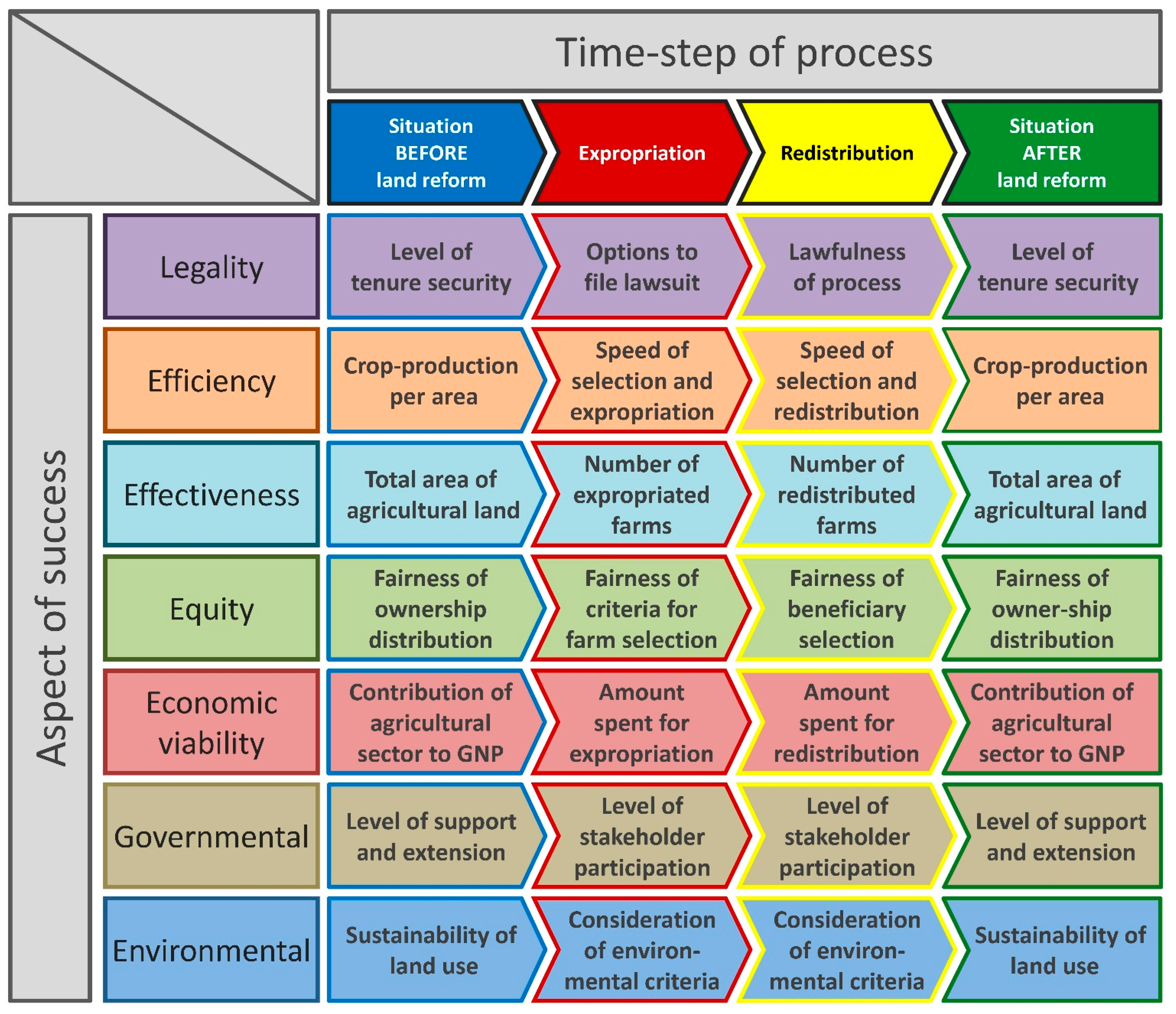
A major reason for difficulties in land reform assessments is the heterogeneity and the contradictoriness of assessment criteria. Some of these criteria are: the pace of redistribution; the improvement of living conditions for beneficiaries; quantitative agricultural production metrics; type and quality of agricultural products; adequacy of compensation of the dispossessed; the security of land tenure; access to land; the effectiveness of administration; the legality and legitimacy of the land reform process, and; land degradation and land use change characteristics. Additional complexity is introduced by contradictions among some of these aspects.
To visualize this complexity of land reform assessment criteria, we structure a selection in
Figure 1. We sorted examples of criteria and related them to one of seven broad aspects of success first. In a second step, we structured the success criteria according to their temporal location within the process of land reform which we split into the initial situation, the processes of expropriation and redistribution and finally the outcome of the process.
Criteria are therefore distinct in terms of their aspect of success and in terms of the time-step they are applied to. If an assessment of land reform would solely focus on questions of efficiency, it could determine the crop production per area either before or after the land reform. To evaluate the efficiency of the process of expropriation or redistribution, the assessment could determine the speed of both processes.
Through this temporal and thematic sorting of the selected criteria, their incomparability becomes explicit by two characteristics:
First, criteria of success are often a snapshot at a specific time-step within the process of land reform and do not describe the whole process or its outcome. Assessing the fairness of expropriation criteria alone may not provide a comprehensive judgment of the overall fairness of a land reform because the resulting distribution of land after the reform could still be unfair.
Second, the seven different aspects of success are thematically not related to each other. While land can be distributed more equitable after the land reform (
a criteria of equity), tenure security might be low (
a criteria of legality) [
25]. Although more land could be cultivated following the land reform (
a criteria of effectiveness), the production outcome could still be less than before (
a criteria of efficiency) [
26].
A
third characteristic is not illustrated through our structuring, but is still apparent after a closer look: Criteria are also differing in terms of their scale. Therefore, land reforms can be assessed on different levels of administration: While the agricultural production of redistributed
households might be better than on their previous plots, the
overall national production might still be low [
27].
These three factors contribute to contradictory views on the success of land reform in Zimbabwe and emphasize the need for a systematic context and for objective methods of data acquisition to evaluate land reform projects. Authors often neglect this variety of arguments and keep narrow foci. Studies which focus on the design of multi-facetted research frameworks with objective and traceable methods to acquire data however are rare. An exception is Deiniger [
28], who provides a general overview of land policy and reform evaluation but without spatial aspects. A comprehensive framework and an applicable methodology for the analysis of this subject are still needed to overcome the lack of data.
Another reason which contributes to disparities in debates on success is the way success criteria are defined. They can be formulated
internally by the participating institutions using specific programmatic goals, or they may be derived from
external, even
universal, criteria. The
Organisation for Economic Co-operation and Development (OECD) therefore distinguishes
performance measurements, where a process is simply assessed against its stated goals, and
process evaluations which include a whole set of examinations of aspects such as policy instruments, service delivery and management practices [
29]. This applies to the FTLRP as well: Marongwe describes an episode of the Zimbabwean government ignoring and failing its own internal land reform criteria for beneficiary selection by favoring elites rather than landless persons as land recipients in areas around the capital city of Harare [
30].
Figure 1.
Structured overview of multidimensional land reform assessment criteria.
Figure 1.
Structured overview of multidimensional land reform assessment criteria.
The heterogeneity of criteria in terms of the seven aspects of success and the perspective of definition bear the risk that these criteria are used selectively. Cousins and Scoones emphasize that not only the definition of success, but also the political view of contributors, largely determines research approach and results [
31]. Their extensive synopsis provides a detailed analysis of diverging land reform criteria in different analytical frameworks [
31]. The authors contrasted approaches to land reform assessment among six socioeconomic paradigms:
neo-classical economics,
new institutional economics,
livelihood perspectives,
welfarist approaches,
radical political economy and
Marxism. As an example, they detail the narrative of productive large commercial farms and unproductive small communal farms. The contrasting views on good management, productive agriculture and adequate land use, which are enshrined in the dual character of local agriculture, exemplify how tenuous and debatable the assessments of land reform are: Some authors see large market based industrial farms (often owned by descendants of European settlers) as the paradigm of productive agriculture. Others focus on the advantages of alternative, regionally adapted models of African small scale agriculture [
32]. Both groups judge the transformation of large farms to smaller farms—often in villagised models—differently according to their ideological background.
Another conspicuous example of criteria selection being the reason for different views in the discourse on land reform success is the published debate that has arisen between Hanlon and Hawkins. Both are economists and have criticized each other in different publications for the use of incorrect success criteria. Hanlon views the reform process as a success, due to increased farmland under production and numbers of people working in the agricultural sector (criteria of effectiveness in
Figure 1). Hawkins counters with “…
the success or otherwise of land resettlement in Zimbabwe cannot be judged by how many people are on the land now, but by what is produced, what incomes are earned and whether the economy as a whole benefitted” [
33] (criteria of efficiency in
Figure 1). Murisa, a Zimbabwean researcher, on the other hand counters that production criteria as such are not relevant and emphasizes the importance of criteria of equity (
Figure 1): “
No one ever argued that this (
the new way)
is a more productive form of farming, but does it share wealth more equitably? Does it give people a sense of dignity and ownership? Those things have value, too” [
34].
These debates which have their roots in the differing backgrounds of authors and the heterogeneity of criteria weaken the discourse on the FTLRP. From his 2010 analysis of opposing factions of land reform research, Southall concluded that it is premature to formulate judgments regarding the success of land reform [
35].
The opposed views on land reform and the acute debate on its success exemplify the need for accurate data that has been mined with traceable, politically neutral methods. Cousins and Scoones concluded furthermore that assessments of viability “…
must embrace heterogeneity, complexity, and competition in relation to multiple objectives… multiple scales… and multiple contexts…” [
31]. Geospatial methods such as remote sensing and
Geographic Information Systems (GIS), are possible solutions to deliver this additional information on the redistribution process and its effects. The data source of remote sensing, satellite or aerial imagery, can be seen as a politically neutral source of information. The processing methods are reproducible and traceable and the generated results are statistically significant at multiple scales.
A closer look at success criteria of land reform evaluation reveals that many of them have a spatial character. This underpins the suitability of geospatial methods to fill data gaps in land reform research. Since these methods can deliver countrywide data on key questions which are consistent in terms of space and time, they can be seen as an important contributions to overcome “
dodgy data” which lead, according to Scoones, to the “
poverty of understanding” [
6]. Before we analyze this potential of geospatial methods, we focus on the current stay of geographical research in the following analytical chapter to demonstrate to which degree this potential has been neglected.
4. The Current Status of Contemporary Research on Zimbabwean Land Reform—From A Geographical Perspective
Although land, its use and tenure are questions of significant spatial relevance, the geographical perspective is generally absent in the discourse on land reform. Cliffe
et al. cite this deficiency in their comprehensive review of the FTLRP in Zimbabwe. It became evident to the authors that, while consensus exists regarding the actuality and nature of agricultural change in Zimbabwe, the location and magnitude of change are in dispute and are seen in many different ways [
24]. Magnitude and location however, are subjects that can be adeptly and accurately addressed within a spatially explicit methodology.
Within the discipline of Geography on the other hand, its potential to enhance understanding of remaining questions on land reforms has been identified already. In his 2008 review “
Geography and Land Reform”, Fraser called for a more systematic contribution by geographers to research about land reform after he emphasized its explicitly spatial character [
36]. Geographical contributions to land reforms, especially the Zimbabwean land reform, however, remain inadequate, principally due to the lack of theory and methodology needed to contribute meaningfully to this research.
We must emphasize our conviction that research on land reform has not been biased in any direction; it has not been systematically in error; nor has it omitted any of the seven criteria aspects presented in
Figure 1. Rather, we acknowledge that the process of land redistribution in Zimbabwe has been one of the most extensively studied and thoroughly discussed land tenure and administration reorientation exercises ever conducted.
However, we carried out a review of published material that underpins our argument of a lack of spatial research within the discourse on land reform. To highlight the lack of spatial input to research, we reviewed articles listed in four principal scientific databases:
Web of Science,
Science Direct,
Google Scholar and
JSTOR. Using specific key words as search parameters, our aim was to quantify spatial aspects included in journal articles dealing with Zimbabwe’s land reform. To the initial search keywords “
land reform” and “
Zimbabwe”, we added the terms “
GIS” or “
remote sensing” in a second and third round to explicitly focus on these geospatial methods. These parameters were applied to title and abstract and, where possible, to the complete text of all references in the databases. No further filtering, such as date of publication, was applied to include all listed publications. The comparison of the different search results, shown in
Table 1, illustrates that very few publications address spatial questions of land reform and do not add spatial data sets to the debate.
In addition to the literature review that utilized methodological keywords, the most recent journal articles on land reform in Zimbabwe were further examined. Using the search parameter “land reform” and “Zimbabwe”, a maximum of 25 articles were selected from each database.
Having identified the publications that included maps and spatial tables, we then segmented them into two generic groups: publications with maps and spatial tables containing original or primary data; and publications with maps and spatial tables containing data derived from other sources. Maps showing climate data sourced from weather services for example, were considered as maps without original content, as were maps which represented study areas. Products from mapping exercises, remote sensing analyses or any other method of visualizing study results were considered as maps or tables with new or original content.
Table 2 details the results of this grouping.
Table 1.
Absolute hits of quantitative literature review for respective parameters and databases.
Table 1.
Absolute hits of quantitative literature review for respective parameters and databases.
| Web of Science | “Topic” | -- |
| “land reform” and “Zimbabwe” | 124 | -- |
| “land reform” and “Zimbabwe” and “GIS” | 1 | -- |
| “land reform” and “Zimbabwe” and “remote sensing” | 0 | -- |
| Science Direct | “Title, Abstract, Keyword” | “All Fields” |
| “land reform” and “Zimbabwe” | 23 | 566 |
| “land reform” and “Zimbabwe” and “GIS” | 0 | 41 |
| “land reform” and “Zimbabwe” and “remote sensing” | 0 | 44 |
| Google Scholar | “Allintitle” | “Full Text” |
| “land reform” and “Zimbabwe” | 89 | 14400 |
| “land reform” and “Zimbabwe” and “GIS” | 0 | 766 |
| “land reform” and “Zimbabwe” and “remote sensing” | 0 | 449 |
| JSTOR | “Abstract” | “Full Text” |
| “land reform” and “Zimbabwe” | 18 | 1264 |
| “land reform” and “Zimbabwe” and “GIS” | 0 | 29 |
| “land reform” and “Zimbabwe” and “remote sensing” | 0 | 26 |
As an additional method to evaluate the methods of current land reform research, we chose to analyze a scientific conference on the topic which took place in March 2013 and which was organized by leading South African research institutes and universities. Titled “
Land Divided”, this symposium attracted approximately 350 international participants [
37]. We chose this gathering of the foremost scholars and institutes, because this conference may be viewed as one of the most significant scientific events of the region concerned with the land reform research.
“
Land Divided” produced 129 discussion panel contributions; 10 dealt with the Zimbabwean land reform. We analyzed the abstracts from these 10 contributions, attempting to identify any that included possible spatial perspectives. Only a single presenter referenced existing maps, which were used for field research. All other presentations were from a non-spatial background, most commonly focusing on politics or sociology. Further, in an attempt to obtain a more general overview of the presented research methodologies, we examined the abstracts of all conference contributions (except plenary lectures). It became evident how extensive and diverse the current debate on land reform is, as it was difficult to segregate the methods described in these contributions into meaningful categories. They were grouped as shown in
Table 3. This review revealed that spatial questions generally were not addressed on the conference. Only 2 out of 82 contributions included any spatial component, and none had a methodological spatial focus. A conclusion in the conference synthesis report states: “…
presentations…highlighted data gaps, poor information management, weak monitoring and evaluation of land reform and poorly targeted agricultural support services” [
38].
Table 2.
Proportions of publications with or without, with cited or created spatial maps and tables.
Table 2.
Proportions of publications with or without, with cited or created spatial maps and tables.
| All Databases | n = 67 | No Spatial Table | Cited Spatial Table | New Spatial Table |
| no map | | 38 | 13 | 1 |
| cited map | | 7 | 5 | |
| new map | | 2 | | 1 |
| Web of Science | n = 22 | No Spatial Table | Cited Spatial Table | New Spatial Table |
| no map | | 15 | 3 | |
| cited map | | 1 | 1 | |
| new map | | 1 | | 1 |
| Science direct | n = 23 | No Spatial Table | Cited Spatial Table | New Spatial Table |
| no map | | 10 | 4 | |
| cited map | | 5 | 4 | |
| new map | | | | |
| Google Scholar | n = 16 | No Spatial Table | Cited Spatial Table | New Spatial Table |
| no map | | 8 | 5 | 1 |
| cited map | | 1 | | |
| new map | | 1 | | |
| JSTOR | n = 6 | No Spatial Table | Cited Spatial Table | New Spatial Table |
| no map | | 5 | 1 | |
| cited map | | | | |
| new map | | | | |
Table 3.
Grouped methods mentioned in all abstracts of the “Land Divided” conference 2013.
Table 3.
Grouped methods mentioned in all abstracts of the “Land Divided” conference 2013.
| Method (If Mentioned) | No Spatial Focus | Spatial Focus |
|---|
| Photography | 5 | |
| Secondary Data | 1 | |
| Household/farm survey (partly with interviews) | 11 | |
| Economical survey/analysis | 3 | |
| Institutional analysis/policy analysis/analysis of interaction of different actors | 12 | |
| Macro-financial analysis | 1 | |
| Ethnographic/long study field work | 7 | |
| Interview | 1 | |
| Historical analysis | 8 | 1 |
| Legal analysis /court case analysis /claims | 13 | |
| Local case studies | 10 | 1 |
| Action-research | 1 | |
| Statistical/demography | 1 | |
| (Non scientific) Literature | 4 | |
| Productivity Analysis | 1 | |
| Survey/questionnaire | 1 | |
| Totals | 80 | 2 |
This corresponds with our analysis that makes clear that spatial aspects and evaluations of the Zimbabwean land reform are not significant in the current scientific literature. Very few recent publications provide new spatial aspects of Zimbabwe’s land reform, although spatial data sets can serve as independent and objective sources for further debate. Spatial data may prove critical in addressing the problem mentioned in
Section 2: the ambiguous and confusing set of land reform objectives, events, and participants that produce discord in assessments of land reform. Therefore, we will present the potential of remote sensing and GIS to contribute to the research on land reform in the following two chapters.
5. The Potential of Remote Sensing to Contribute to the Research on Land Reform
In general, spatial methods have great potential to create added value in social research. Goodchild and Janelle emphasize this by giving two main arguments for the consideration of space in social research:
first, location provides possibilities to integrate multidisciplinary approaches, and;
second, location adds to the three principal questions of social research: human behavior and resulting processes; their prediction; and problem solutions [
39].
Remote sensing in particular, can answer a number of questions on land reform which are related to agriculture. This suitability is rooted in the characteristics and determinants of agricultural production: Unlike other forms of economic production, the seasonal spatial patterns of agriculture are influenced by physical and human impacts and their effects are directly expressed on the land surface as variances over large proportions of the agricultural area [
40].
Satellite products have been used for decades to conduct a broad variety of significant vegetation analyses [
41] since Tucker and his colleagues emphasized the linkage between spectral reflectance and vegetation greenness in the 1980s [
42]. From that time, critical issues related to agricultural production have been at the center of remote sensing research: Analyses of biomass, crop acreage estimates, and yields/area. In addition to these quantitative, spatially explicit data, satellite imaging provides temporal continuous data sets over long-term acquisition periods. This is important, because time series data sets for long-term analyses have not been available for land reform research. In her 2008 work documenting economic successes of Zimbabwe’s land reform, Zikhali states that a temporal comparative analysis of land reform is not possible due to a lack of continuous chronological data [
43].
In the past, remote sensing based monitoring of vegetation has proven to successfully answer general agricultural questions in Southern Africa in a cost effective, standardized and spatially explicit manner. Some of these questions are at the heart of the debate regarding success criteria of land reform. These critical agricultural issues include for instance the evaluation of farm value [
44] as the basis to assess
equity (
Figure 1) and the updating of the conventional concept of Zimbabwe’s agro-ecological zones [
45] as an improved mechanism to answer questions of
economic viability (
Figure 1).
To further elaborate the potential of remote sensing, we will present a range of studies which demonstrate that this method can resolve important spatial issues directly related to Zimbabwe’s agriculture. To structure our descriptive review of remote sensing studies for land reform research, we chose spatial success criteria of the aspects
efficiency,
effectiveness and
environmental sustainability (as shown in
Figure 1). For these, we present current shortcomings in research and successful remote sensing applications to overcome these.
6. The Potential of Web-Mapping as A Tool to Retrieve Spatial Information on Land Reforms
To benefit from the positive impacts of spatial input on social research presented by Goodchild and Janelle [
39], a strategy is needed to link the results of remote sensing to human activities reliably. At the same time, simplifications of cause and effect between tenure and land use change have to be avoided [
70]. Although remote sensing is able to detect changes in land use patterns, it is not able to relate them to land reform events that have occurred in Zimbabwe. The innovative concept
Public Participatory Geographic Information Systems (PPGIS), provides good solutions to establish this spatial socio-ecological link. PPGIS is a mechanism to enable diverse members of the community to contribute their relevant knowledge as spatial data. Mining land tenure and land use change information this way can minimize the necessity for time consuming and costly
in situ land ownership change mapping based on household surveys or site visits [
71].
By definition, participatory approaches to GIS seek to involve in the mapping process non-experts who have detailed knowledge of local conditions such as land use strategies. This approach has been successfully applied in a number of different environments, mostly in the field of land tenure and resource mapping [
72]. A principal reason for participation is to include in the process indigenous or local residents, who have often been ignored or marginalized in previous programs. By participating in the mapping effort, a broad range of individuals can contribute in a variety of ways [
73].
E‑participation focuses on the participation of larger groups, not bounded within a geographic area. Through online tools and Web-GIS, forms of participation expanded [
74], because Technologies of the second generation internet technologies offer numerous opportunities to engage large groups of people to share their geospatial knowledge through interactive applications [
75].
A well-designed online spatial questionnaire therefore provides a solution to map the land use and land tenure changes of the past by drawing on local knowledge of people. Such maps would overcome the lack of spatial information on expropriation and redistribution. By easily sharing geospatial data, people from an international diaspora, who were affected by land reform events, can share their knowledge on expropriated farms through an online tool that associates their information with spatial location. The dataset on farm evictions could first be used by itself to analyze a number of assessment criteria presented in
Figure 1, including
efficiency (
speed of expropriation), or
effectiveness (
total area of expropriated farms) and general spatial patterns of redistribution. Secondly, the PPGIS can be used to mine information on previous land use strategies. This dataset can then be used to validate the land use datasets based on remote sensing.
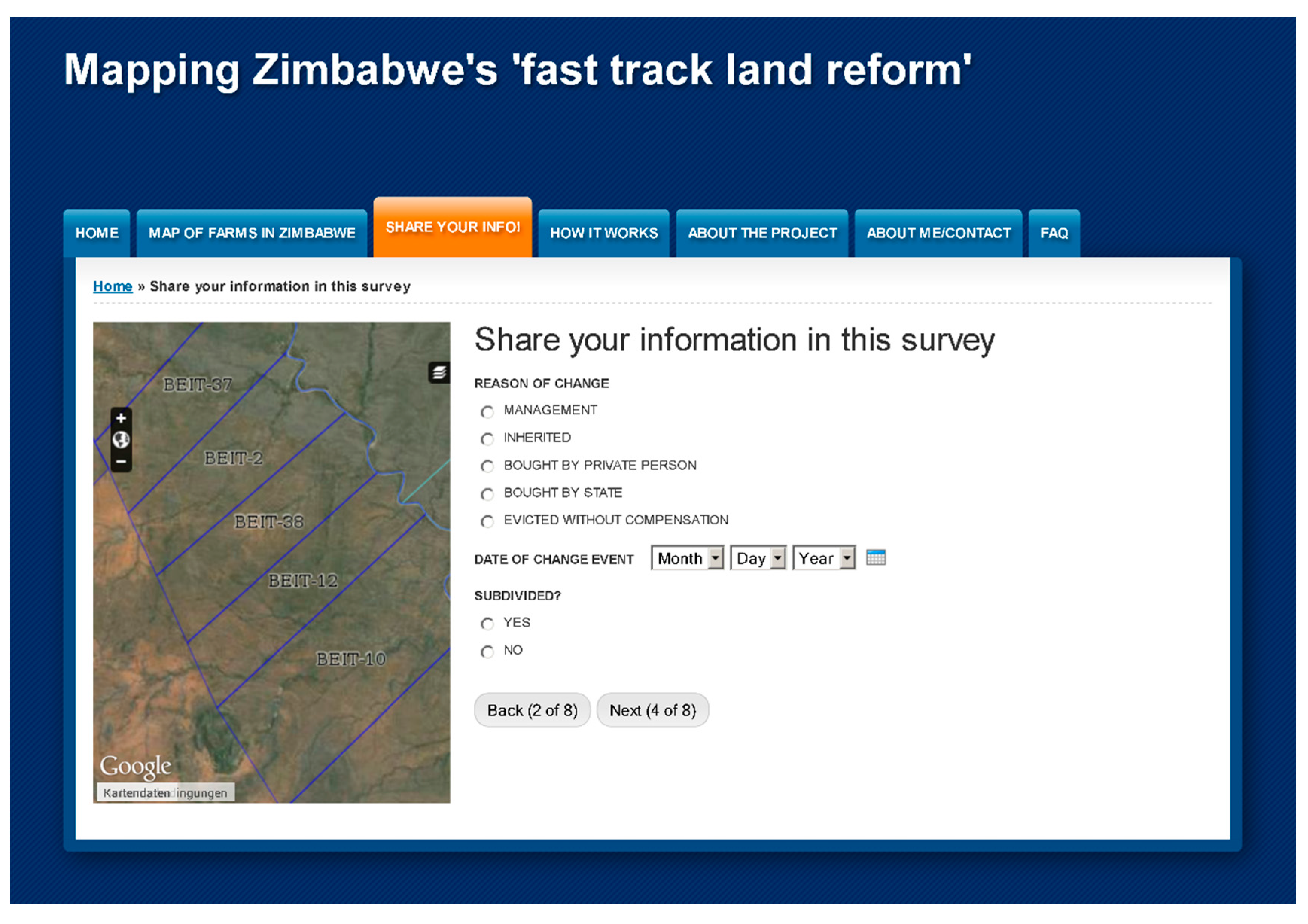
Figure 2 details an example of one element of an online participation tool on Zimbabwe’s land reform. Here, participants can enter the details of a change they allocated previously to an identified farm through a web-map application.
Figure 2.
Screenshot of mapping portal.
Figure 2.
Screenshot of mapping portal.
7. A Methodological Framework for the Spatial Research of Land Reform
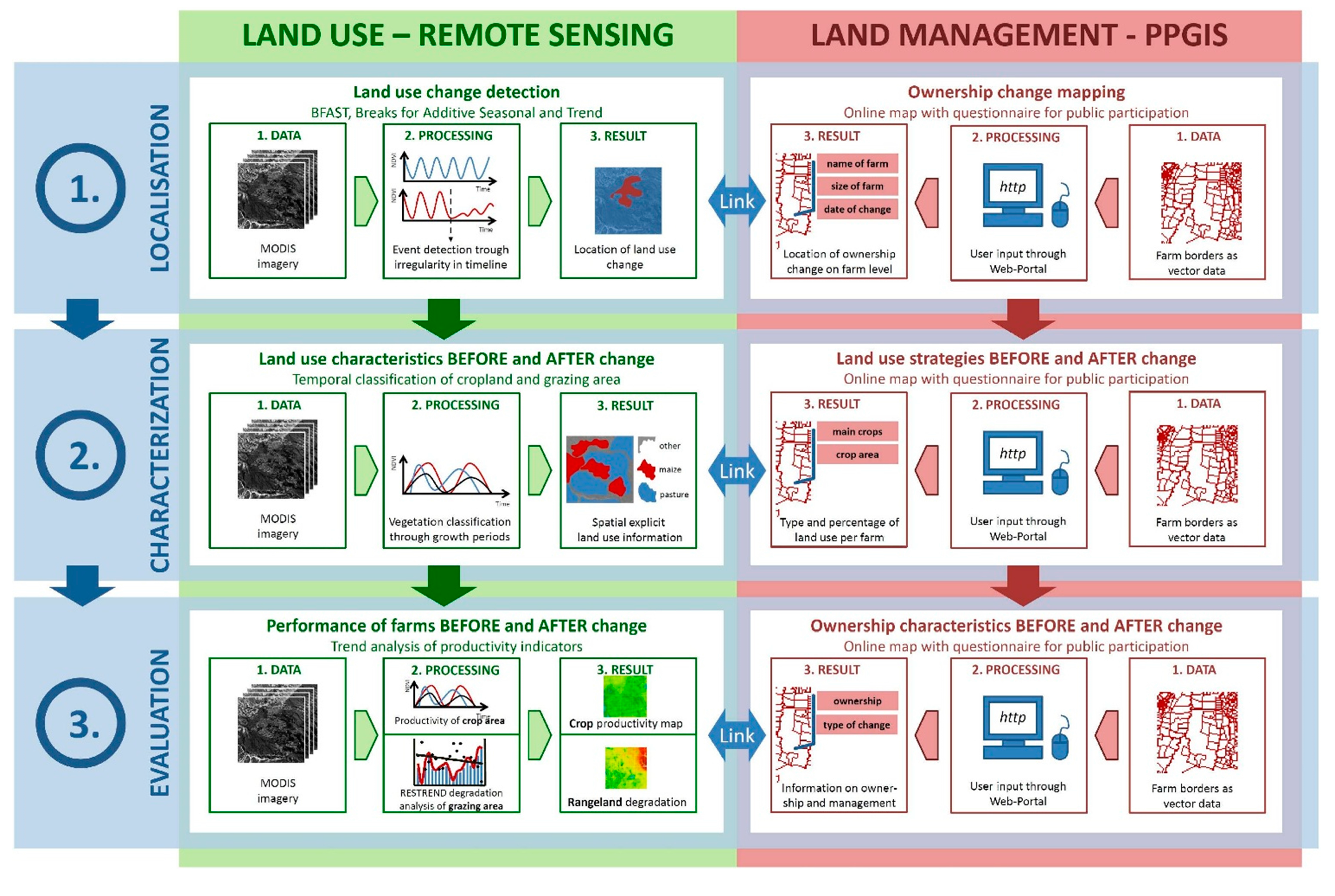
Considering the huge potential of remote sensing and PPGIS to answer various questions surrounding land reform presented above, we are convinced of that Zimbabwe’s fast track land reform program and its effects can be mapped on a national basis. To make use of this potential, we present here a framework for mapping the national reorganization of land tenure and its effects. By combining the spatiotemporal strength of both methods, we attempt the first spatial explicit comparison of agricultural production among different tenure regimes.
This spatial correlation has to be treated with care because numerous studies have concluded that simple regressions between land tenure and land cover change, or even agricultural productivity, have to be drawn with great caution. Changes in agricultural management and production are the result of a combination of various factors [
54]. For too long, however the lack of agricultural data of has prevailed in the discourse on success of land reforms in Southern Africa. Agricultural figures have been selectively cited, have been “
guessed after various factors” [
76] by officials and are compiled from considerably underfunded institutions. Conversely, in their 2007 review of interdisciplinary spatial-temporal studies of African land use change, Guyer
et al. conclude that the remote sensing community has not sufficiently considered the linkages between the “
natural and human worlds” [
77].
The analytic structure proposed in
Figure 3 must be tested for its applicability as well as its facility to link Guyer’s “
natural and human worlds”. It is characterized by three elements of spatial-temporal analysis:
localization,
characterization and
comparison. All elements will be worked on “
in the natural world” by remote sensing and “
in the human world” by the PPGIS approach. The following sections describe the steps and methodological approaches in detail.
Figure 3.
Research framework: linking land use change and ownership change by means of remote sensing and public participatory geographic information system (PPGIS).
Figure 3.
Research framework: linking land use change and ownership change by means of remote sensing and public participatory geographic information system (PPGIS).
7.1. Localization of Change Events
The first challenge of land reform mapping involves the spatial characterization of the anthropogenic variables of land ownership and land management. The second requires the correlation of land ownership/management with the physical world of land use and land cover. Important political and collective decisions, which lead to changes in land tenure must be accurately fixed in time and space, this will be accomplished through the PPGIS approach. In our research framework, an interactive web portal will be utilized to account for ownership changes of demarcated farms. Here, participants are asked to provide general information, such as
name and
size, on farms they recognize and identify on an associated detailed web map. In a second step (see
Figure 2), respondents will be asked to provide the
reason for ownership change and the
date of change, as well as to provide information regarding whether or not the specified entity has been subject to subdivision [
78]. As a result, expropriations of farms are mapped spatially and temporally.
Time series remote sensing data will be used to locate physical land use changes. The
Breaks for Additive Seasonal and Trend (BFAST) analysis method offers distinct advantages in time series analyses by decomposing reflectance values into trend, seasonal and remainder constituents. This allows identification of abrupt changes in land use over the course of several years and they can be separated from regional trends and seasonal change patterns of vegetation. Changes in cropping patterns can therefore be located with an automated spatial approach because of their changing reflection patterns, which are not associated with either general or seasonal trends [
79].
By spatially correlating evicted farms with land use change events, land reform effects can be estimated countrywide. The results can be used to identify volatile land use “hot spots” where changes can be attributed to a variety of factors, including lack of investment and operating capital, deficient knowledge base, and labor shortages. This change analysis process can then serve as a basis for further studies.
7.2. Characterization of Change Events
After locating and correlating land use and land tenure change events, the proposed framework aims to characterize these changes. The online survey tool will be used to acquire information on changing land use strategies. Participants will be prompted to enter information on crops in production both before and after ownership changes and, if possible, also estimate the planted area and grazing area for each farm. These cropland and grazing area specifications will serve as primary information on land use strategies of changing ownership and management; they will also provide data for use in verifying the accuracy of the satellite based analysis.
To characterize the land use change, we propose a temporal crop masking and classification methodology based on MODIS data. As shown above, temporal classification has been applied in various contexts and provides reliable crop type identification and crop production area calculations. With this method, crop types (and grazing land) can be accurately identified and mapped on an annual basis due to the characteristic reflectance values of different plant types in different growth phases [
56].
The resulting annual land cover data sets will capture periods before and after changes in land tenure. Through the applied spatial correlation, these data will provide critical information on the effects that these changes have on land use and allow visualization of their spatial dimension. Change maps can also provide information that is of immediate use for land use planning and management analysis.
7.3. Evaluation of Situation before and after Change Event
Finally a comparison of plant
productivity before and after the mapped and characterized change events will be performed. This will be limited to a comparison of harvest and biomass per area and is not meant to provide a thorough evaluation of land reform because of the complexities surrounding the determination of success of land reforms discussed previously in
Section 3. The online survey will provide information on farm
ownership both
before and
after the change event. In addition, users can specify the
reason for ownership change to associate the type of change event with the effects on land use productivity and sustainability.
By using MODIS data, the framework will assess the potential of these data to directly associate changes of crop production with change events of Zimbabwe’s land reform. Furthermore, an analysis of grazing land degradation will be carried out through the application of a
Residual Trend Analysis (RESTREND). The RESTREND method compares residuals of NDVI values with a long-term trend, and allows separation of observed episodes of diminishing plant health and production from long term trends associated with or caused by climatic conditions. Applications of MODIS and RESTREND have demonstrated the utility of this approach to differentiate between human induced and natural degradation at regional scales [
80]. We will implement and test this procedure to identify and characterize vegetation degradation in southern Africa rangeland environments.
Any comparison of pre- and post- land reform agricultural production levels must be performed carefully and two important factors must be considered: (1) the varying causes of land use change or degradation, and; (2) the lack of sufficient, multi-temporal, medium resolution image coverage. The FTLRP was implemented in Zimbabwe beginning in the year 2000. The year 2000 is also the earliest date for which MODIS data products are available which makes a comprehensive temporal comparison based solely on MODIS data impossible. Correlation of early land reform events can only be accomplished by performing a regional spatial comparison of redistributed farms with non-transferred neighboring farms throughout the course of the following years. This method would allow evaluation of whether or not the potential productivity of a given agricultural unit is fully realized.


