Article

Forefronting the Socio-Ecological in Savanna Landscapes through Their Spatial and Temporal Contingencies

Department of Geography & the Environment, The University of Texas at Austin, 305 E. 23rd Street, CLA 3.306, Austin, TX 78712, USA
*
Author to whom correspondence should be addressed.
Land 2013, 2(3), 452-471; https://doi.org/10.3390/land2030452
Submission received: 18 July 2013 / Revised: 23 August 2013 / Accepted: 26 August 2013 / Published: 5 September 2013

Abstract

:
Landscape changes and the processes driving them have been a critical component in both research and management efforts of savanna systems. These dynamics impact human populations, wildlife, carbon storage, and general spatio-temporal dynamism in response to both anthropomorphic and climatic shifts. Both biophysical and human agents of change can be identified by isolating their respective spatial, temporal, and organizational contingencies. However, we argue here that a significant portion of savanna research has either considered humans as exogenous (e.g., via enacting regional or broader policies) or somewhat spatio-temporally removed from the system (e.g., as in many protected areas with limited current human habitation). Examples from African savanna research and particularly those systems of southern Africa are thus reviewed and used to model a stylized or prototypical savanna system and contingencies. Such an approach allows for a richer socio-temporal integration of theories and data on past biophysical and human histories to facilitate an improved framework for understanding savanna systems and their complex contingencies as socio-ecological landscapes.

1. Introduction

It has long been recognized that the interplay among spatial and temporal processes collectively shapes and modifies the spatial patterns that constitute the Earth’s land cover at a particular point in time [1,2,3,4,5,6]. In particular the spatio-temporal patterns that characterize natural, anthropogenic, and hybrid land covers have been explored through approaches as wide-ranging as hybrid impacts on species persistence [7], socio-ecological statistical and temporal variances in biodiversity conservation [8], and land use assessment change scenarios [9]. Here we seek to pull together the common but still underexplored threads of such efforts, complemented by our own field studies in savanna systems, as a means of better integrating ongoing efforts to examine natural and human interactive processes across dynamically interacting temporal and spatial scales and potentialities. We refer to these as spatial and temporal contingencies, and argue that this perspective indicates that savannas might be denoted more properly with regards to how they exist over time rather than in what state they might be at a given instant of time.
Over the past century, researchers have developed numerous means to describe and understand patterns and processes, with the ultimate goal of ascertaining causality and forecasting with requisite certainty. The linkage of pattern to process is a critical part of the scientific method as it potentially furthers the goals of (1) developing the capacity to predict future outcomes or resiliencies in particular landscapes and (2) creating theory to generalize explanations useful in other places or kinds of landscapes. Land use/land cover change (LULCC) studies in particular have offered spatially explicit, theoretically rich, and analytically sophisticated case studies and modeling efforts that include assessing contributory components to landscape change such as: the effects of adding spatial constraints; temporal controls tied to concurrent climatic and institutional change; access inequalities, migration, and other socio-behavioral data; and multi-scale management scenarios and outcomes. What this suite of approaches collectively offers is a way to isolate and identify scale-related and scale-specific phenomena.
We posit that these opportunities are especially important for savannas, whose composition, structure, and function strongly reflect landscape legacies while also responding quickly, ecologically speaking, to shifts in disturbance regimes, climatic conditions, and management. In these systems, both of the two above-stated goals are facilitated by evaluating complexities of change through time [10,11,12,13,14,15]. In landuse/landcover change studies, temporal data—whether in the form of from-to or paneled landscape change classes—can clarify causality in some cases or simplify the number of causal agents to consider in others [16,17]. In other academic realms, data on historical legacies and on consequences of spatial adjacency have been used to evaluate disease movement [18,19], species diversity [20,21,22], and woody encroachment [14,23,24,25].
Here we present a selective review on the consequences of the recent efforts to quantify and predict patterns, processes of change, and dynamism of the Earth’s terrestrial socio-ecological systems with particular attention to savanna systems as elucidated by our own field studies. Insights have come from land change science [26,27,28,29], been informed by political ecology [30,31], investigated vulnerability and resilience [32,33,34], spanned the human-environment nexus in both practice [26] and theory [35,36], and been inspired by differently conceived operationalizations of scale from ecology and systems theories [37,38,39]. Landscapes can be simplified as produced by flows of energy and matter that are historically and spatially contingent. In addition, observation of these contingencies is scale-dependent. Research approaches that address these concerns at the landscape level provide a conceptual means to combine historical and current process measurements with landscape pattern data and projections [40,41,42,43,44].
We begin with an overview of the main genres of landscape and landscape change studies, and how landscapes have been quantified, characterized, and theorized. This overview is followed by revisiting published treatments of spatial, temporal, and spatio-temporal contingencies in turn, utilizing a stylized [45] or prototype savanna landscape where humans are an embedded part of that socio-ecological system. From this exploration, the theoretical worth of a contingencies framework in dynamic savanna systems is discussed, with the goal of facilitating the adaption of previous studies of savanna landscape change in limited human-interaction settings to those that more realistically present the socio-ecological context of southern Africa’s savannas.

2. Landscape Dynamism and Spatial Contingency

Landscape ecology utilizes the concept of landscape as a spatial mosaic, defined by a (background) matrix with patches of differing sizes and shapes [4,46,47]. Terrestrial landscapes are thus modeled or quantified in relation to the forms created by the patches and their spatial arrangements. Different types of patches can be identified, depending on the spatial heterogeneity inherent to the study area and in relation to analytical goals and scale of data, e.g., [5,48,49,50]. Patch dynamics are mapped via tracking the fluctuation of patch edges as patches change in shape, size, composition, and perimeter-to-area ratio. The need for these kinds of measurements in the study of disturbance ecology and nonequilibrial conditions [51,52] coincided with the development of different means to quantify landscape forms [53,54], to evaluate scale [55,56], and to create simplified landscapes as simulation models [38,57].
From work in both land change science and landscape ecology [29,42], it is clear that spatial heterogeneity and neighborhood effects often impact the immediate future potential of vegetation and other landcovers in a given area. That is, neighbors matter not only for edge effects but as importantly for changing the larger spatial context (the level “above” in hierarchy theory—n.b. [58]) in which that vegetation is couched. For example, places with the exact same history of composition and configuration of biotic and abiotic components will likely evolve very differently if surrounded by mature forest versus urban development versus agriculture. This kind of neighborhood influence has been expressed as the manifestation of flows of material and energy (as in landscape ecology: [4]), the dispersal of propagules and competitive effects of neighbors (as in plant ecology: [59,60]), spatial autocorrelation (as in geography: [61,62]; as in ecology: [63]), and scale-dependent interconnectedness [37,64] and has been monitored both remotely [65] and with vegetation inventory data [66]. In land cover studies, remotely sensed imagery allows for wall-to-wall classification and mapping of broad areas [67]. This coverage facilitates modeling future change at the pixel (or more recently, object) level in a way constrained and/or informed by the cover types of user-defined neighbors [68,69,70]. These neighborhood effects range in probability of impact, degree and type of control, and spatial footprint of control extent: here we label these functions as “spatial contingency”.
Figure 1 represents a prototype savanna and, though inspired by field research in the central Kalahari, has been generalized to fit savanna models more broadly [71]. The prototype illustrates a savanna matrix with a mixture of grassed and wooded patches, wherein plant establishment is affected by the kind and location of both fires and impacts by large herbivores (grazing, browsing, trampling, and—in the case of elephants—knocking over). Plant dispersal, colonization, burns, herbivory, and trampling all affect (or potentially affect) neighboring patches. These spatial implications are expected to display spatial thresholds at which explanatory power of these processes changes [59,72,73,74].
Figure 1. Stylized Socio-ecological Savanna System Contingencies: Presented here are spatial processes effecting change in a hypothetical landscape with a grassland-woodland mosaic with two underlying soil types (their border represented by the dashed line). These change agents include vegetation ecology processes and those associated with disturbances caused by fires and large herbivores. Shown also are temporal contingencies, including historical legacies such as where forest patches were located in the past, with resulting spatio-temporal change over several time steps.
Land 02 00452 g001
In the case of Figure 1, processes affecting individual plants and their regeneration will be important at a micro-scale, while a climatic regime that alters through time the frequency and intensity of fires, or alternatively a policy change that alters agricultural practices, might be more explanatory at a macro-scale. The identification of these spatial thresholds provides a means to evaluate which agents of change are most influential at particular scales and inter-patch distances and, in turn, at which scales further investigation should be conducted. Their assessment also expands ways that the role of nonequilibrial processes can be conceptualized [75].
With regards to spatial scales, functional levels, and land change processes, there is a specific class of spatial contingency that bears mention as the bane of data collection and scaling efforts: organizational level. In the social domain this organization is associated with settlement or political units that can be found in nested hierarchies (e.g., households, settlements, municipalities, districts, provinces or states). Biophysical levels used are typically nested hierarchies that relate to topographic controls (e.g., watersheds, drainage basins). Geographic levels used often are non-nested hierarchies that are a function of distance (whether in time or space) from certain features (e.g., accessibility zones). These levels are easy to understand separately, but taken together on a given landscape their possible overlapping permutations and combinations result in a seemingly disconcordant set of landscape stratifications.
And yet, dominant and detectable higher order patterns emerge from that chaos. The mechanism for that emergence is well represented in the (bio)complexity literature [76], where the colloquialism “complexity isn’t complex” is often heard. The resulting emergent patterns may at first glance seen overly simplified, but in fact are the result of explicit recognition and incorporation of the above organizational levels and their varied factors at work under certain contingent conditions [38]. Explicit consideration of organizational hierarchies and organizational contingencies might therefore be one way to amalgamate the social, biological, and physical science approaches needed, and appears a fruitful path for revealing deeper insights and therefore producing better predictability.

3. Landscape Dynamism and Temporal Contingency

Process-based studies perhaps obviously include a temporal component, since processes by definition occur over time and are rarely observable at a static point in time (only their impacts are). Landscape and multi-scale approaches are also typically longitudinal to some degree, as an understanding of landscape processes that impact land cover or land use is greatly improved by addressing the nature of change over time.
Figure 1 was conceptualized by the authors to illustrate how a simplified savanna landscape could change over ten time intervals as ecological succession processes interact with disturbance agents [77,78]. Sites with the same composition and configuration of abiotic and biotic components as well as similarly configured neighbors may develop differently based upon their “inheritance” or landscape legacy. For example, a hypothetical site surrounded by woodlands may have been covered by trees itself until recently. The likely future land cover of this site would be different from another site that had been through many years of a land use type that had, until recently, kept it free from woody vegetation. Ecological succession is affected by pre-existing conditions, the nature of the disturbance event(s) or regime(s), and the types of propagules that arrive from neighboring areas [3,79,80]. Disturbance regimes characterize the type, intensity, magnitude, and frequency of occurrence of land cover changing events [81,82].
Land cover types may persist, alternate with, or permanently transform to other types [83]. Savanna systems in particular are known for their fluctuations from human, other biotic, and abiotic influences; while many of these processes have been studied for some time [84], it remains unclear whether, when, and in what capacity humans have a stabilizing, destabilizing, or neutral impact on savanna systems and in particular on tree-grass ratios [84]. The nature of these temporal interactions varies with local historical circumstances that are often incredibly heterogeneous over time and space given the rich complexity of legacies of highly variable precipitation and historical use throughout southern African savannas. These temporal interactions and their manifestations further vary with spatial scale (grain and extent of spatial observation) and temporal scale (extent of time period under study and frequency of observation). Panel analyses of changes in landscape patterns detected in multi-temporal assemblages of remotely sensed images [17,53,85] are useful in this regard. They can reveal “changes in the changes” when, for example, the predominant landscape elements alter their sizes or adjacencies from time period one to time period two in a manner different from that observed from time period two to time period three (e.g., Figure 1). In turn, these results would suggest that causality of change agents (or their interactive consequences) had shifted in intensity or type of process(es) involved.
Some land covers or land uses may effectively prevent certain land covers from occurring in the [near] future (e.g., urban asphalt precluding the quick return of woody plant species, floodwaters kill off and keep out Acacia spp.) while making others more likely (e.g., fire-exposed soils facilitating pioneer plant species). Further, land cover and land use themselves also inherit political, economic, and social legacies as well that impact both landscape and landscape processes [86,87]. All of these kinds of historical legacies or inheritances can be labeled as “temporal contingency”. As with spatial contingencies they vary in terms of probability of impact, degree and type of control, and extent (here, temporal) of control.
Temporal contingencies also perplex landscape researchers in a unique way: how do we uncover and then represent processes at work on the landscape hundreds to thousands of years ago [88]? Obviously, today’s landscapes have been acted upon by a temporal cascade of events and processes both anthropogenic and biophysical (“natural”) in origin. Over time periods of centuries to millennia, evolutionary processes such as natural selection and extinction also begin to shape the biota that forms and alters land cover.
At best our synoptic views of the landscape from remotely sensed data go back anywhere from 40 years (commercially/publicly available multi-spectral satellite sensors) to 155 years (unmanned balloon photography—for a complete history, see Jensen [67]). Travel diaries kept by explorers during colonial expansion have proven extremely useful in understanding general land cover of the times [89] and some long-standing government records (e.g., cropping yields from China) help to remind us of the legacies of past landscapes, climates, and human practices [90]. African savanna systems have in particular benefited from review of such records. In southern Africa, missionary David Livingstone (1813–1873), artist Thomas Baines (1820–1875), hunter-photographer James Chapman (1831–1872), and journalist Sir Henry Morton Stanley (1841–1904) all explored and recorded various aspects of the African savanna systems that inform of us earlier landscapes and landscape practices whose legacies can be seen today, though perhaps interpreted differently by scientists, stakeholders, and policymakers depending upon their own positionalities (e.g., Fairhead and Leach [91] for contested interpretations of local historical land management practices as related to social constructions of “nature”). But these sources are few and their spatial coverage limited, and so there is a paucity of datasets reaching back far enough in time to establish a deeper baseline. The areas and practices of historical ecology, paleo-ecology, and long-term conservation [92,93,94] and other historical approaches need to be better incorporated into these managerial [92] and research ventures [93,94] to bring in datasets and expertise involving longer time and to allow for fuller development of the longer-term perspective critical in temporal contingencies to unraveling explanations of why savannas have developed the ways they have under varying degrees of human, other biotic, and abiotic influences.
Given a certain landscape or place, it is theoretically possible to evaluate the relative and possibly interactive contribution of spatial and temporal agents in altering land cover and land use. For example, Figure 1 shows the mosaic’s landscape change through time and also as interactively modified by disturbances and vegetation recovery processes. Change analysis of landscapes of this type can be carried out at multiple spatial scales by using remotely sensed data acquired with different grains and extents, permitting the identification of important kinds and agents of landscape change for each respective scale examined. Sampling in the field on transects that stretch along an environmental gradient or otherwise sample variation from one landscape or patch type to another is yet another way to evaluate landscape change and controls thereof [95].
Accompanied by additional information about past social and other changes in the study area, these kinds of research could enable decoupling of effects of spatial scale from those caused by historical [temporal] contingency in a manner suitable for replication in other spatio-temporal landscapes, both with and without important anthropogenic influences. Thus the relative explanatory power of spatial change versus temporal change versus spatiotemporal change could be analyzed statistically for the partial explanatory value of each component given the presence of the others—while paying due attention to spatial and temporal autocorrelation [96] and non-stationarity [97]. That is, spatial contingency, temporal contingency, and their interaction can be disentangled for not only natural but also human processes.

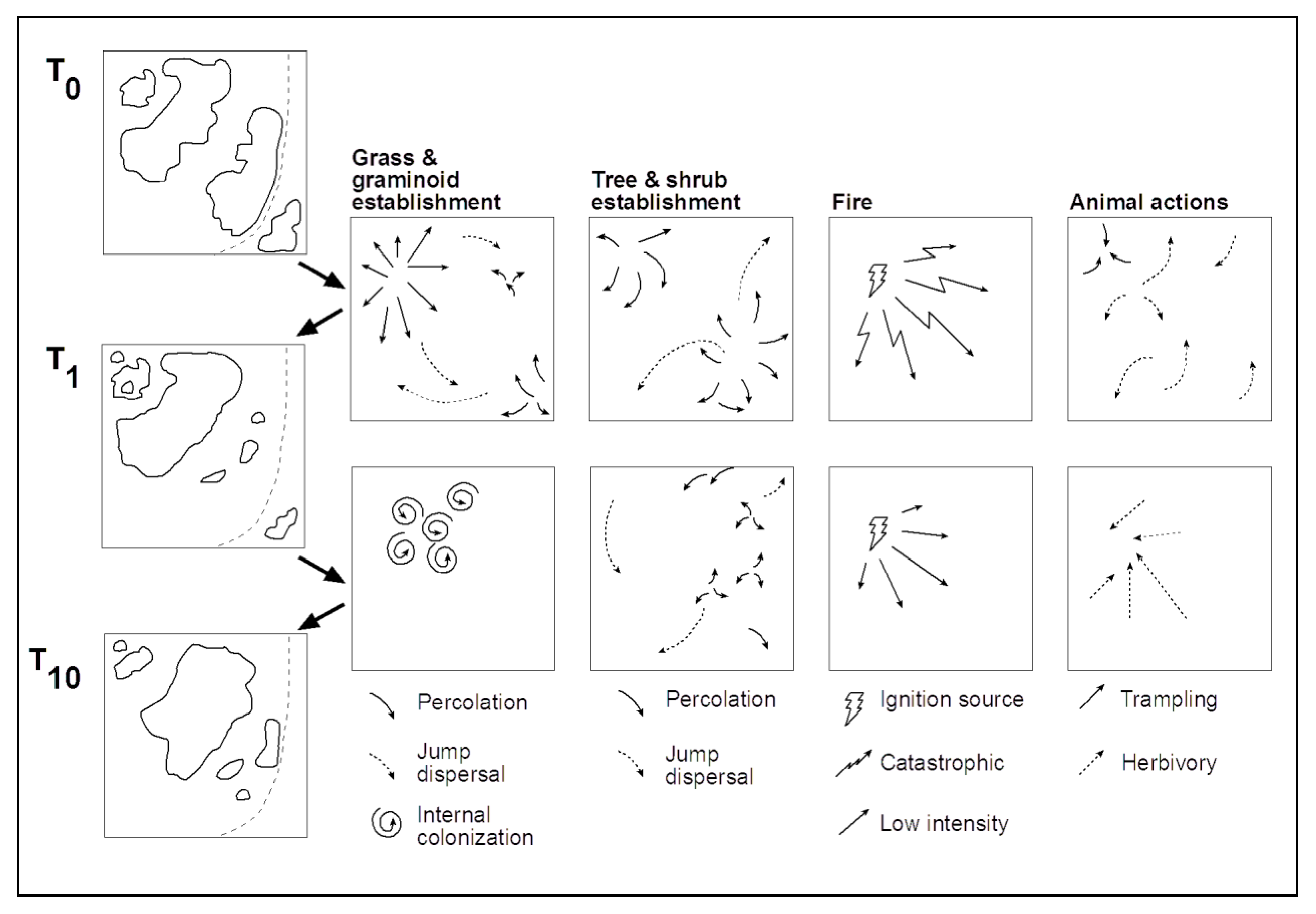
4. Contingencies in Practice

The stylized savanna landscape with its mixture of grassed and wooded patches shown in Figure 1 has been conceptualized with an underlying environmental gradient associated with soil type and soil moisture shifts (shown as a dashed line that separates the landscape into two, unequal portions). This underlying biophysical heterogeneity predisposes the degree of influence of fire to remove woody plants completely over time, presumably most effective on a soil type more favorable to dominance by grasses following disturbance. The shifting mosaic of woodlands embedded in a grassland matrix results from stochastic events: the specific place of ignition (e.g., by poachers or by lightning strike) or the happenchance involved with herbivory and trampling by large animals, with all of these as shaped by the dispersal and establishment of individual plants. But there is also a degree of predictability due to underlying edaphic change and resulting from the historical legacy of having relatively large patches of woodland in some places in the landscape that resist complete burning from relatively cool fires as documented in much of the central Kalahari [98].
The woodlands in Figure 1 change through time in terms of number of patches, shape and edge length, spatial arrangements and inter-patch distances, and degree of perforation and fragmentation. These are all features that can be routinely quantified with landscape metrics. Human agency on this landscape could be evaluated in terms of possible or actual changes on fire regimes (suppression, accidental ignition, increased ignition, deliberate burning), on presence and abundance of large herbivores (hunting, introduction of domesticated livestock/disease), and on the types of plant species present (over-harvesting, introduction of non-native species). As illustrated here and in terms of possible future outcomes, a given (spatio-temporal) location is impacted by inherited legacies that may be expressed temporally (e.g., path dependency), spatially (e.g., spatial autocorrelation), or organizationally (e.g., trophic relationships or local-to-global socioeconomic and political (anthropogenic) processes) as well as through their interactive effects.
Returning once more to Figure 1, it would be possible to interrogate the situation portrayed in terms of contingencies explored across natural (N) and anthropogenic (A) impacts. The role of abiotic and biotic factors influencing the survival or even dominance of woody plants in a seasonal grassland prone to fire has been said to be a function of (N1) competition by herbaceous plants for soil water [99], (N2) seasonal fluxes in soil water availability [100], (N3) the role of spatial gradients in rainfall and rainfall seasonality [101], (N4) strong influences of edaphic properties if these change spatially thus creating an ecotone [102], (N5) facilitation of seedling establishment by site amelioration from larger woody plants [103,104], (N6) interactive effects of large herbivores and fires [105], (N7) the variable abundance (and influence) of grazers and browsers in relation to habitat heterogeneity [106], and (N8) the interaction over time of rainfall variability, fire regimes, and tree establishment, or lack thereof [107]. Conceptual and analytical models that incorporate some of these aspects use (N9) climate data as inputs [108,109], and specifically (N10) length of dry season [110], (N11) the life history characteristics of the plants [111], (N12) landscape ecology and GIScience principles applied to vegetation dynamics [112].
Anthropogenic influences on landscapes such as characterized in Figure 1 have been evaluated in terms of (A1) invasive plants [113], (A2) livestock impacts [114], (A3) altered land use practices [115], (A4) changes in livelihoods, tourism, and conservation [116,117,118,119], (A5) possible feedbacks of land cover change to climate change [120], (A6) land tenure and land use goals [121], (A7) national development policies [122], (A8) multi-scale influences on and of land use [123,124], and (A9) human-induced climate change [27].
Consider now the landscape of Figure 1: if it were subdivided into sectors under differing land tenure, resource management, or political regimes, the social organizational dimensions would improve predictability and provide much necessary contextual and process-related explanation.

5. Field Observations of Socio-Ecological Savannas

The previous example illustrates two inherent complexities in understanding socio-ecological savanna systems. First, the very definition of savanna—whether oriented around cover distribution, function, or species—indicates that in some ways savannas are always potentially ephemeral. As a biome, they shift rather easily and quickly into woodlands or grasslands from factors anthropogenic (e.g., fire suppression), biotic (e.g., woody encroachment), and abiotic (e.g., change in precipitation regime). Thus, savannas might be denoted more properly with regards to how they exist over time rather than in what state they might be at a given instant. Second, savannas highlight—as shown in Figure 1 and the previous discussion—the necessity of viewing these systems as socio-ecological in large part because of the spatio-temporally interwoven nature of “natural” and “anthropomorphic” factors.
Another example as observed in our central Kalahari field studies (including both repeat vegetation transects and semi-structured household interviews) relates to Combretum mopane (English common name Mopane or Mophane), a species valued in veld collection (typically for construction, fencing, and firewood because of its straight trunk and high wood density, respectively). This species also seems to be heavily browsed by elephants.
Consider an area containing C. mopane that commonly occurs in parts of western Botswana in the Okavango Delta, notably in areas with clayey soils. Multiple field campaigns (including vegetation surveys, informal interviews with local residents/land managers, and ground-truthing of high resolution land cover time series) inspired the following prototypical scenario, an early phase of which is illustrated in Figure 2. Suppose a household locates an area in which they will attempt to grow maize crops for the local dietary staple, pap (a porridge, typically made from maize or sorghum). First the area will be cleared of all vegetation, with useful plants being reserved for other purposes: C. mopane will be used elsewhere or sold, and the thorny Acacia spp. or Dichrostachys cinerea (English common name Sicklebush) collected and used to surround the field as a high, deep thorny fence (similar to a spiky hedgerow) in order to keep out domestic livestock and wildlife. While the field is actively being cultivated, little changes. But external events such as shifts in annual precipitation, availability/subsidization of drought-tolerant maize seed, fire disturbances, and out-migration may each result in the abandonment of the field. While the trees had been cleared (manually and without the use of a deep-reaching plow), typically the root structure remains in the ground, enabling the plant to re-sprout within short periods of time.
Figure 2. Combretum mopane [re]sprouting in an abandoned agricultural field in northwestern Botswana: The fence separates an abandoned agricultural area (on left) from open access where grazing and trampling may occur. Note the spread of c. mopane in the forefront. Photo by second author.
Land 02 00452 g002
With no immediate competition, C. mopane re-sprouts quickly, investing primarily in trunk height and shooting up quickly in even-age (and roughly even-height) stands. Due to minor differences in site specific conditions, some individuals will achieve an intraspecific advantage and grow faster into tall stands with relatively straight stems (multi-stem growth form). These individuals will eventually be harvested for construction material (given the preference for tall, straight poles for such a use), and the cycle repeats. Meanwhile, as other woody and herbaceous species begin to grow up between C. mopane plants, the C. mopane smaller trees and larger branches are selectively harvested in proportion to demand, primarily sold after some aging (to dry) for firewood both for locals and for sale to tourists for campfires and cooking (notably the self-drive industry). Elephant browsing in the area may also result in the tops eaten off of the C. mopane trees, which then continue to re-branch from the point of removal.
This creates an appearance, in heavily browsed areas, of even-age stands at similar heights as had been there previously but with significantly thicker trunks and branches from the top-pruning. Thus, a myriad of anthropogenic and natural factors fold in upon each other in complex contingent patterns resulting in a shifting mosaic proto-typical of a socio-ecological savanna system.

6. Future Prospects

This research approach thus offers a way to tie together multidisciplinary efforts to examine natural and human interactive processes across temporal and spatial (including organizational) scales [125,126]. Land use/land cover change (LULCC) studies in particular have offered spatially explicit, theoretically rich, and analytically sophisticated case studies [26,28,29,38]. Further, this effort complements and enriches recent modeling efforts that involve LULCC and are already exploring the effects of adding spatial constraints [127], temporal controls tied to concurrent climatic and institutional change [128], landscape metrics [129], migration and other socio-demographic data [130], behavioral rules [33], and management outcomes [131,132,133]. It also provides another example of a research methodology designed to isolate and identify scale-related and scale-specific phenomena [134,135,136].
Recasting ecological and social explanations in terms of their respective spatial and temporal contingencies provides more explicit explanations when tied to actual complex landscapes. Modeling has been oriented towards providing predictions of climate change consequences [137], to develop stochastic simulations of fire and plant succession [99], to test a central place approach designed to mimic livestock management practices [127], and to create agent-based models that can incorporate different goals of pastoralists [138]. Revisiting these modeling approaches and crafting additional means to include local, regional, and global influences would add scalar nuances to the examination of human land use practices, goals, or legacies.
The premise of land change science is that the interplay among spatial and temporal patterns and processes collectively shapes and modifies the Earth’s land use and land cover. Observation of emergent impacts of spatial and temporal contingencies is necessarily scale-dependent and often nonlinear. Representation of different human units (e.g., timber concessions, communities and settlements, as well as access to each of these) as agents is useful for understanding their scale and scope of impact and organization. In general, it may be expected that spatial contingencies will be more important at finer scales of inquiry and less so at coarser scales of inquiry. That is, neighborhood effects are better predictors of landuse/landcover change (LULCC) and human response at finer spatial scales. Examining the role of sub-continental and larger phenomena such as climatic oscillations and mass political migrations might necessarily imply a level of agency requiring a coarser spatial scale of inquiry. The same is often true of temporal scale, which has been shown to often co-vary positively with spatial scale [42]. Thus the urban regentrification process may last only a few decades and extend throughout a neighborhood, while glaciation is a much slower process that typically spans a much broader area. There are notable exceptions, such as earthquakes lasting only minutes but having continent-wide impacts, but the basic premise remains: explicit consideration of the spatial and temporal footprints of processes and patterns is critical for understanding landscape change. Further, the reach of landscape change processes is anisotropic. For example, globalization and urbanization are both transforming rather isolated areas [139], but tend to do so along the transportation corridors that provide access to people and mobility for the shipment of goods.
The Anderson landscape characterization scheme proposed in 1976 offers guidance for the extraction of land use and land cover from differently (spatially) scaled data to create “levels” of nested-hierarchical schema whereby each level offers greater thematic detail as spatial resolution improves [140]. The “Anderson Level 1” is associated with land cover over large expanses for multiple audiences; land use is interspersed as levels increase. It is likely that social organizational scales will be more important in areas of either greater population density or lower topographic gradients and at finer spatio-temporal scales, while biophysical scales are expected to emerge at coarser spatiotemporal scales and in areas of greater topographic difference. The key question in a system then becomes at what threshold, range, or flip point are the system boundaries of these two spheres observable [36,42]? Agents of change are likely constrained by such topographic and physical environmental influences as elevation, slope, and aspect [141], while physical accessibility and connectivity will influence the direction and kind of LULCC [142]. One consequence is that change is more likely to come from new processes acting on the landscape, rather than being due to the spread of existing processes to new places. In turn, this expectation creates testable hypotheses for landscape researchers.
Enacting a contingency-explicit perspective may be partly constrained or complicated by computing limitations, distance of interacting phenomena (e.g., the “reach” of a peri-urban settlement), or the extent of reliable field data. Perhaps obviously, it is difficult to model the effects of higher level (e.g., national or provincial, international) policies because they are difficult to measure, non-quantitative in nature, or relatively invariable or too highly variable over the space (and time) under study. Exceptions include those that reflect market forces (e.g., wages and prices of key outputs), to the extent that they vary over space or time and that data are available and where their effects may be filtered through local communities.
A contingency-focused landscape change assessment would focus on identifying and characterizing factors that cause shifts through time. Multi-temporal analysis from within one calendar year (intra-annual) could be used to characterize the size and distribution of land classes changing due to seasonality. Those factors could originate from biophysical and/or policy regimes (including hunting, land tenure, and conservation policy), while seasonal shifts could be due to cyclic factors, such as phenology of vegetation [143,144,145,146] and/or migration for seasonal employment [54,147]. The degree of change due to yearly (inter-annual) seasonality could be compared to temporal change over intra-decadal cycles (e.g., via panel analysis as in [16,54] or via harmonic regression and wavelet analysis [144]). Of particular temporal interest might be the role of disturbances and disturbance regimes in affecting landscape patterns through time and space, which would need to be evaluated in a similar way. Some spatial changes in landscape units may not be due to seasonality or land use practices, but rather must have been caused by other agents of change, including ecological succession. The political analog of changing local, regional, and state regimes could be similarly analyzed. Similar to the previous steps, the amount of change due to disturbance and recovery processes (ecological or anthropogenic) could determine if and how they would be incorporated into subsequent analyses and at which scales.
Consideration of spatial contingencies would next include, for example, environmental gradients for the particular study area. These gradients would be defined as those spatial changes in larger-extent constraints (e.g., edaphic or climatic or governmental) that strongly influence the kinds of land use practiced. A biophysical example might include degree and type of influence of elevation and slope on land units in upland or terrace sites compared to lowland or floodplain areas. A policy-related example might include tenure or usage zones or civil infrastructure. The larger point is that explicit consideration not just of spatial and temporal scales but moreover of spatial and temporal contingencies (what processes happen under what conditions at which spatial or temporal scales) is of paramount importance to understanding landscape change and landscape themselves.
Returning to savanna systems, the take-home lesson of this selected review is that the myriad approaches that have been used to investigate spatial and temporal scales might be better collectively focused to turn to spatial and temporal contingencies as conceptual guidance. Savannas in particular are highly complex, highly dynamic socio-ecological systems. Just as hierarchy theory has long argued for the consideration of spatial scales “above” and “below” the observational scale of interest, with savanna systems it is similarly important to consider temporal scales (both grain and extent) “above” and “below” the temporal scale of observation. Socio-ecological system components themselves may be differently defined as natural, anthropogenic, or hybrid depending upon the scale(s) of observation as well as past and future contingencies that indicate the relative and interactive influence of these potentialities. Savanna systems research may be better informed by moving beyond attempts such as defining function vis-à-vis morphological structure and instead working to catalog and define these systems and landscapes as spatio-temporal contingency entities.

Acknowledgments

The authors wish to acknowledge the National Science Foundation awards NSF BCS # 0942211 and NSF BCS # 0964596 for support of fieldwork used to inform this article. The first author’s work on this manuscript was supported by the National Science Foundation while she was working at the Foundation. Any opinions, findings, conclusions, or recommendations expressed in this material are those of the authors and do not necessarily reflect the views of the National Science Foundation. While Figure 1 was conceptualized and drawn by the authors, they gratefully acknowledge the digital rendering by Philip H. Page. The article clearly benefited in scope and strength from the comments of anonymous reviewers, with particular thanks to Reviewer 1.

Conflicts of Interest

The authors declare no conflict of interest.

References

  1. Lee, W.T. The Face of the Earth as Seen from the Air: A Study in the Application of Airplane Photography to Geography; American Geographical Society Special Publication No. 4. Conde Naste Press: Washington, DC, USA, 1922. [Google Scholar]
  2. Sauer, C.O. The Morphology of Landscape; University of California Press: Berkeley, CA, USA, 1925. [Google Scholar]
  3. Glenn-Lewin, D.C.; Peet, R.K.; Veblen, T.T. (Eds.) Plant Succession: Theory and Application; Chapman and Hall: London, UK, 1992.
  4. Forman, R.T.T. Land Mosaics: The Ecology of Landscapes and Regions; Cambridge University Press: Cambridge, UK, 1995. [Google Scholar]
  5. Pickett, S.T.A.; Cadenasso, M.L. Landscape ecology: Spatial heterogeneity in ecological systems. Science 1995, 269, 331–334. [Google Scholar]
  6. Rhoads, B.L.; Thorn, C.E. The Scientific Nature of Geomorphology; Wiley: Chichester, UK, 1996. [Google Scholar]
  7. Acácio, V.; Holmgren, M.; Moreira, F.; Mohren, G.M.J. Oak persistence in Mediterranean landscapes: The combined role of management, topography, and wildfires. Ecol. Soc. 2010, 14, 40. [Google Scholar]
  8. Duncan, S.L.; McComb, B.C.; Johnson, K.N. Integrating ecological and social ranges of variability in conservation of biodiversity: Past, present, and future. Ecol. Soc. 2010, 15, 5. [Google Scholar]
  9. Helming, K.; Pérez-Soba, M. Landscape scenarios and multifunctionality: Making land use impact assessment operational. Ecol. Soc. 2011, 16, 50. [Google Scholar]
  10. Scholes, R.J.; Archer, S.R. Tree-grass interactions in savannas. Ann. Rev. Ecol. Syst. 1997, 28, 517–544. [Google Scholar] [CrossRef]
  11. Petit, C.; Scudder, T.; Lambin, E. Quantifying processes of land-cover change by remote sensing: Resettlement and rapid land-cover changes in south-eastern Zambia. Int. J. Remote Sens. 2001, 22, 3435–3456. [Google Scholar] [CrossRef]
  12. House, J.I.; Archer, S.; Breshears, D.D.; Scholes, R.J. Conundrums in mixed woody–herbaceous plant systems. J. Biogeogr. 2003, 30, 1763–1777. [Google Scholar] [CrossRef]
  13. Folke, C.; Gunderson, L. Challenging complexities of change: The first issue of ecology and society. Ecol. Soc. 2004, 9, 19. [Google Scholar]
  14. Sankaran, M.; Hanan, N.P.; Scholes, R.J.; Ratnam, J.; Augustine, D.J.; Cade, B.S.; Gignoux, J.; Higgins, S.I.; Le Roux, X.; Ludwig, F.; et al. Determinants of woody cover in African savannas. Nature 2005, 438, 846–849. [Google Scholar] [CrossRef]
  15. Sano, E.E.; Ferreira, L.G.; Asner, G.P.; Steinke, E.T. Spatial and temporal probabilities of obtaining cloud-free Landsat images over the Brazilian tropical savanna. Int. J. Remote Sens. 2007, 28, 2739–2752. [Google Scholar] [CrossRef]
  16. Mertens, B.; Lambin, E.F. Land-cover-change trajectories in Southern Cameroon. Ann. Assoc. Am. Geogr. 2000, 90, 467–494. [Google Scholar] [CrossRef]
  17. Crews-Meyer, K.A. Characterizing landscape dynamism via paneled-pattern metrics. Photogramm. Eng. Remote Sens. 2002, 68, 1031–1040. [Google Scholar]
  18. Xu, X.-M.; Madden, L.V. Use of SADIE statistics to study spatial dynamics of plant disease epidemics. Plant Pathol. 2004, 53, 38–49. [Google Scholar] [CrossRef]
  19. Breed, A.C.; Field, H.E.; Smith, C.S.; Edmonston, J.; Meers, J. Bats without borders: Long-distance movements and implications for disease risk management. EcoHealth 2010, 7, 204–212. [Google Scholar] [CrossRef]
  20. Tilman, D.; Knops, J.; Wedin, D.; Reich, P.; Ritchie, M.; Siemann, E. The influence of functional diversity and composition on ecosystem processes. Science 1997, 277, 1300–1302. [Google Scholar] [CrossRef]
  21. Mazurek, M.J.; Zielinski, W.J. Individual legacy trees influence vertebrate wildlife diversity in commercial forests. For. Ecol. Manag. 2004, 193, 321–334. [Google Scholar] [CrossRef]
  22. Ricklefs, R.E. History and diversity: Explorations at the intersection of ecology and evolution. Am. Nat. 2007, 170, S56–S70. [Google Scholar] [CrossRef]
  23. Trollope, W.S.W. Ecological Effects of Fire in South African Savannas. In Ecology of Tropical Savannas; Huntley, B.J., Walker, B.H., Eds.; Springer-Verlag Ecological Studies: Berlin, Germany, 1982; Volume 42, pp. 292–306. [Google Scholar]
  24. Ringrose, S.; Matheson, W.; Wolski, P.; Huntsman-Mapilaa, P. Vegetation cover trends along the Botswana Kalahari transect. J. Arid Environ. 2003, 54, 297–317. [Google Scholar] [CrossRef]
  25. Brudvig, L.A.; Asbjornsen, H. Dynamics and determinants of Quercus alba seedling success following savanna encroachment and restoration. For. Ecol. Manag. 2009, 257, 876–884. [Google Scholar] [CrossRef]
  26. Liverman, D.; Moran, E.F.; Rindfuss, R.R.; Stern, P.C. People and Pixels: Linking Remote Sensing and Social Science; National Academy Press: Washington, DC, USA, 1998. [Google Scholar]
  27. DeFries, R.S.; Field, C.B.; Fung, I.; Collatz, G.J.; Bounoua, L. Combining satellite data and biogeochemical models to estimate global effects of human-induced land cover change on carbon emissions and primary productivity. Glob. Biogeochem. Cy. 1999, 13, 803–815. [Google Scholar] [CrossRef]
  28. Rindfuss, R.R.; Walsh, S.J.; Turner, B.L., II; Fox, J.; Mishra, V. Developing a science of land change: Challenges and methodological issues. Proc. Natl. Acad. Sci. USA 2004, 101, 13976–13981. [Google Scholar] [CrossRef]
  29. Turner, B.L., II; Lambin, E.F.; Reenberg, A. The emergence of land change science for global environmental change and sustainability. Proc. Natl. Acad. Sci. USA 2007, 104, 20666–20671. [Google Scholar]
  30. Zimmerer, K.S.; Bassett, T.J. Political Ecology: An Integrative Approach to Geography and Environment-Development Studies; Guilford Press: New York, NY, USA, 2003. [Google Scholar]
  31. Turner, B.L., II; Robbins, P. Land-change science and political ecology: Similarities, differences, and implications for sustainability science. Annu. Rev. Environ. Resour. 2008, 33, 295–316. [Google Scholar] [CrossRef]
  32. Turner, B.L., II; Kasperson, R.E.; Matson, P.A.; McCarthy, J.J.; Corell, R.W.; Christensen, L.; Eckley, N.; Kasperson, J.X.; Luers, A.; Martello, M.L.; et al. A framework for vulnerability analysis in sustainability science. Proc. Natl. Acad. Sci. USA 2003, 100, 8074–8079. [Google Scholar] [CrossRef]
  33. Walker, R.; Drzyzga, S.A.; Li, Y.; Qi, J.; Caldas, M.; Arima, E.; Vergara, D. A behavioral model of landscape change in the Amazon basin: The colonist case. Ecol. Appl. 2004, 14, S299–S312. [Google Scholar] [CrossRef]
  34. Gunderson, L.; Folke, C. Resilience 2011: Leading transformational change. Ecol. Soc. 2011, 16, 30. [Google Scholar]
  35. Turner, B.L., II; Matson, P.A.; McCarthy, J.J.; Corell, R.W.; Christensen, L.; Eckley, N.; Hovelsrud-Broda, G.K.; Kasperson, J.X.; Kasperson, R.E.; Luers, A.; et al. Illustrating the coupled human-environment system for vulnerability analysis: Three case studies. Proc. Natl. Acad. Sci. USA 2003, 100, 8080–8085. [Google Scholar] [CrossRef]
  36. Ostrom, E. A general framework for analyzing sustainability of social-ecological systems. Science 2009, 325, 419–422. [Google Scholar] [CrossRef]
  37. Peterson, D.L.; Parker, V.T. Ecological Scale: Theory and Applications; Columbia University Press: New York, NY, USA, 1998. [Google Scholar]
  38. Brown, D.G.; Riolo, R.; Robinson, D.T.; North, M.; Rand, W. Spatial progress and data models: Toward integration of agent-based models and GIS. J. Geogr. Syst. 2005, 7, 25–47. [Google Scholar] [CrossRef]
  39. Walsh, S.J.; Messina, J.P.; Mena, C.F.; Malanson, G.P.; Page, P.H. Complexity theory, spatial simulation models, and land use dynamics in the northern Ecuadorian Amazon. Geoforum 2008, 39, 867–878. [Google Scholar] [CrossRef]
  40. Zimmerer, K.S.; Young, K.R. Nature’s Geography: New Lessons for Conservation in Developing Countries; University of Wisconsin Press: Madison, WI, USA, 1998. [Google Scholar]
  41. Walsh, S.J.; Butler, D.R.; Malanson, G.P. An overview of scale, pattern, process relationships in geomorphology: A remote sensing and GIS perspective. Geomorphology 1998, 21, 183–205. [Google Scholar] [CrossRef]
  42. Turner, M.G.; Gardner, R.H.; O’Neill, R.V. Landscape Ecology in Theory and Practice: Pattern and Process; Springer-Verlag: New York, NY, USA, 2001. [Google Scholar]
  43. Walsh, S.J.; Crews-Meyer, K.A. Linking People, Place, and Policy: A GIScience Approach; Kluwer Academic Press: Norwell, MA, USA, 2002. [Google Scholar]
  44. Prober, S.M.; O’Connor, M.H.; Walsh, F.J. Australian Aboriginal peoples’ seasonal knowledge: A potential basis for shared understanding in environmental management. Ecol. Soc. 2011, 16, 12. [Google Scholar]
  45. Walsh, S.J.; Mena, C.F.; DeHart, J.L.; Frizzelle, B.G. Stylized environments and ABMs: Educational tools for examining the causes and consequences of land use/land cover change. Geocarto Int. 2009, 24, 423–435. [Google Scholar] [CrossRef]
  46. Urban, D.L.; O’Neill, R.V.; Shugart, H.H., Jr. Landscape ecology. Bioscience 1987, 37, 119–127. [Google Scholar] [CrossRef]
  47. Burel, F.; Baudry, J. Landscape Ecology: Concepts, Methods and Applications; Science Publishers: Enfield, NH, USA, 2003. [Google Scholar]
  48. Haines-Young, R.; Chopping, M. Quantifying landscape structure: A review of landscape indices and their application to forested landscapes. Prog. Phys. Geogr. 1996, 20, 418–445. [Google Scholar] [CrossRef]
  49. Yarrow, M.M.; Marín, V.H. Toward conceptual cohesiveness: A historical analysis of the theory and utility of ecological boundaries and transition zones. Ecosystems 2007, 10, 462–476. [Google Scholar] [CrossRef]
  50. Shima, J.S.; Noonburg, E.G.; Phillips, N.E. Life history and matrix heterogeneity interact to shape metapopulation connectivity in spatially structured environments. Ecology 2010, 91, 1215–1224. [Google Scholar] [CrossRef]
  51. White, P.S.; Jentsch, A. The search for generality in studies of disturbance and ecosystem dynamics. Prog. Bot. 2001, 62, 399–450. [Google Scholar] [CrossRef]
  52. Kennedy, R.E.; Cohen, W.B.; Schroeder, T.A. Trajectory-based change detection for automated characterization of forest disturbance dynamics. Remote Sens. Environ. 2007, 110, 370–386. [Google Scholar] [CrossRef]
  53. Crews-Meyer, K.A. Temporal extensions of landscape ecology theory and practice: Examples from the Peruvian Amazon. Prof. Geogr. 2006, 58, 421–435. [Google Scholar] [CrossRef]
  54. Malanson, G.P.; Zeng, Y.; Walsh, S.J. Landscape frontiers, geography frontiers: Lessons to be learned. Prof. Geogr. 2006, 58, 383–396. [Google Scholar] [CrossRef]
  55. Mast, J.N.; Chambers, C. Integrated approaches, multiple scales: Snag dynamics in burned versus unburned landscapes. Prof. Geogr. 2006, 58, 397–405. [Google Scholar] [CrossRef]
  56. Southworth, J.; Cumming, G.S.; Marsik, M.; Binford, M.W. Linking spatial and temporal variation at multiple scales in a heterogeneous landscape. Prof. Geogr. 2006, 58, 406–420. [Google Scholar] [CrossRef]
  57. Baker, W.L. Longterm response of disturbance landscapes to human intervention and global change. Landsc. Ecol. 1995, 10, 143–159. [Google Scholar] [CrossRef]
  58. Allen, T.F.H. The Landscape “Level” is Dead: Persuading the Family to Take it off the Respirator. In Ecological Scale: Theory and Application; Peterson, D.L., Parker, V.T., Eds.; Columbia University Press: New York, NY, USA, 1998; p. 608. [Google Scholar]
  59. Crawley, M.J. Plant Ecology; Blackwell Science: Oxford, UK, 1997. [Google Scholar]
  60. Uriarte, M.; Condit, R.; Canham, C.D.; Hubbell, S.P. A spatially explicit model of sapling growth in a tropical forest: Does the identity of neighbours matter? J. Ecol. 2004, 92, 348–360. [Google Scholar] [CrossRef]
  61. Tobler, W.R. A computer movie simulating urban growth in the Detroit region. Econ. Geogr. 1970, 46, 234–240. [Google Scholar] [CrossRef]
  62. Griffith, D.A. Spatial Autocorrelation: A Primer; Association of American Geographers: Washington, DC, USA, 1987. [Google Scholar]
  63. Legendre, P. Spatial autocorrelation: Trouble or new paradigm? Ecology 1993, 74, 1659–1673, 63. Legendre, P. Spatial autocorrelation: Trouble or new paradigm? Ecology1993, 74, 1659-1673.. [Google Scholar] [CrossRef]
  64. Millington, A.C.; Velez-Liendo, X.M.; Bradley, A.V. Scale dependence in multitemporal mapping of forest fragmentation in Bolivia: Implications for explaining temporal trends in landscape ecology and applications to biodiversity conservation. Photogramm. Eng. Remote Sens. 2003, 57, 289–299. [Google Scholar] [CrossRef]
  65. Stuart, N.; Barratt, T.; Place, C. Classifying the Neotropical savannas of Belize using remote sensing and ground survey. J. Biogeogr. 2006, 33, 476–490. [Google Scholar] [CrossRef]
  66. Nangendo, G.; Steege, H.; Bongers, F. Composition of woody species in a dynamic forest-woodland-savannah mosaic in Uganda: Implications for conservation and management. Biodivers. Conserv. 2006, 15, 1467–1495. [Google Scholar] [CrossRef]
  67. Jensen, J.R. Remote Sensing of Environment; Prentice Hall: Upper Saddle River, NJ, USA, 2000. [Google Scholar]
  68. Jensen, J.R. Introductory Digital Image Processing: A Remote Sensing Perspective, 2nd ed.; Simon and Schuster: Upper Saddle River, NJ, USA, 1996. [Google Scholar]
  69. Anderson, J.J.; Cobb, N. Tree cover discrimination in panchromatic aerial imagery of pinyon-juniper woodlands. Photogramm. Eng. Remote Sens. 2004, 70, 1063–1068. [Google Scholar]
  70. Sarkar, S.; Crews, K.A.; Young, K.R.; Kelley, C.D.; Moffett, A. A dynamic graph automata approach to modeling landscape change in the Andes and the Amazon. Environ. Plan. B 2009, 36, 300–318. [Google Scholar] [CrossRef]
  71. Hill, M.J.; Hanan, N.P. Current Approaches to Measurement, Remote Sensing, and Modeling in Savannas: A Synthesis. In Ecosystem Function in Savannas: Measurement and Modeling at Landscape to Global Scales; Hill, M.J., Ed.; CRC Press: Hoboken, NJ, USA, 2010; pp. 515–545. [Google Scholar]
  72. Ahl, V.; Allen, T.F.H. Hierarchy Theory: A Vision, Vocabulary, and Epistemology; Columbia University Press: New York, NY, USA, 1996. [Google Scholar]
  73. Walker, R.; Meyers, J.A. Thresholds in ecological and social-ecological systems: A developing database. Ecol. Soc. 2004, 9, 3. [Google Scholar]
  74. Peters, D.P.C.; Gosz, J.R.; Pockman, W.T.; Small, E.E.; Parmenter, R.R.; Collins, S.L.; Muldavin, E. Integrating patch and boundary dynamics to understand and predict biotic transitions at multiple scales. Landsc. Ecol. 2006, 21, 19–33. [Google Scholar] [CrossRef]
  75. Perry, G.L.W. Landscapes, space and equilibrium: Shifting viewpoints. Prog. Phys. Geogr. 2002, 26, 339–359. [Google Scholar] [CrossRef]
  76. Cadenasso, M.L.; Pickett, S.T.A.; Grove, J.M. Dimensions of ecosystem complexity: Heterogeneity, connectivity, and history. Ecol. Complex. 2006, 3, 1–12. [Google Scholar] [CrossRef]
  77. Dietz, H.; Edwards, P.J. Recognition that causal processes change during plant invasion helps explain conflicts in evidence. Ecology 2006, 87, 1359–1367. [Google Scholar] [CrossRef]
  78. Laris, P. Humanizing savanna biogeography: Linking human practices with ecological patterns in a frequently burned savanna of southern Mali. Ann. Assoc. Am. Geogr. 2011, 101, 1067–1088. [Google Scholar] [CrossRef]
  79. Pickett, S.T.A.; Collins, S.L.; Armesto, J.J. Models, mechanisms and pathways of succession. Bot. Rev. 1987, 53, 335–371. [Google Scholar] [CrossRef]
  80. Belyea, L.R.; Lancaster, J. Assembly rules within a contingent ecology. Oikos 1999, 86, 402–416. [Google Scholar] [CrossRef]
  81. Veblen, T.T.; Hadley, K.S.; Nel, E.M.; Kitzberger, T.; Reid, M.; Villalba, R. Disturbance regime and disturbance interactions in a Rocky Mountain subalpine forest. J. Ecol. 1994, 82, 125–135. [Google Scholar] [CrossRef]
  82. Kulakowski, D.; Veblen, T.T.; Bebi, P. Effects of fire and spruce beetle outbreak legacies on the disturbance regime of a subalpine forest in Colorado. J. Biogeogr. 2003, 30, 1445–1456. [Google Scholar] [CrossRef]
  83. Pontius, R.G., Jr.; Shusas, E.; McEachern, M. Detecting important categorical land changes while accounting for persistence. Agric. Ecosyst. Environ. 2004, 101, 251–268. [Google Scholar] [CrossRef]
  84. Sinclair, A.R.E.; Arcese, P. Serengeti II: Dynamics, Management and Conservation of an Ecosystem; The University of Chicago Press: Chicago, IL, USA, 1995; p. 665. [Google Scholar]
  85. Crews-Meyer, K.A. Agricultural landscape change and stability: Historical patch-level analysis. Agric. Ecosyst. Environ. 2004, 101, 155–169. [Google Scholar] [CrossRef]
  86. Bassett, T.J.; Zuéli, K.B. Environmental discourses and the Ivorian savanna. Ann. Assoc. Am. Geogr. 2000, 90, 67–95. [Google Scholar] [CrossRef]
  87. Van Apeldoorn, D.F.; Kok, K.; Sonneveld, M.P.W.; Veldkamp, T.A. Panarchy rules: Rethinking resilience of agroecosystems, evidence from Dutch dairy-farming. Ecol. Soc. 2011, 16, 39. [Google Scholar]
  88. Young, K.R.; Aspinall, R. Kaleidoscoping landscapes, shifting perspectives. Prof. Geogr. 2006, 58, 436–447. [Google Scholar] [CrossRef]
  89. Butzer, K.W.; Helgren, D.M. Livestock, land cover, and environmental history: The Tablelands of New South Wales, Australia, 1820–1920. Ann. Assoc. Am. Geogr. 2005, 95, 80–111. [Google Scholar] [CrossRef]
  90. Lambin, E.F.; Geist, H.J.; Lepers, E. Dynamics of land-use and land-cover change in tropical regions. Annu. Rev. Environ. Resour. 2003, 28, 205–241. [Google Scholar] [CrossRef]
  91. Fairhead, J.; Leach, M. Misreading the African Landscape: Society and Ecology in a Forest-Savanna Mosaic; Cambridge University Press: Cambridge, UK, 1996; p. 354. [Google Scholar]
  92. Egan, D.; Howell, E.A. (Eds.) The Historical Ecology Handbook: A Restorationist’S Guide to Reference Ecosystems; Island Press: Washington, DC, USA, 2001.
  93. Willis, K.J.; Bennett, K.D.; Froyd, C.; Figueroa-Rangel, B. How can a knowledge of the past help to conserve the future? Biodiversity conservation strategies and the relevance of long-term ecological studies. Philos. Trans. R. Soc. Series B 2007, 362, 175–186. [Google Scholar] [CrossRef]
  94. Cerling, T.E.; Wynn, J.G.; Andanje, S.A.; Bird, M.I.; Kimutai Korir, D.; Levin, N.E.; Mace, W.; Macharia, A.N.; Quade, J.; Remien, C.H. Woody cover and hominin environments in the past 6 million years. Nature 2011, 476, 51–56. [Google Scholar] [CrossRef]
  95. Duvall, C.S. Biocomplexity from the ground up: Vegetation patterns in a west African savanna landscape. Ann. Assoc. Am. Geogr. 2011, 101, 497–522. [Google Scholar] [CrossRef]
  96. Diniz-Filho, J.A.F.; Bini, L.M.; Hawkins, B.A. Spatial autocorrelation and red herrings in geographical ecology. Glob. Ecol. Biogeogr. 2003, 12, 53–64. [Google Scholar] [CrossRef]
  97. Fotheringham, A.S.; Brunsdon, C.; Charlton, M. Geographically Weighted Regression: The Analysis of Spatially Varying Relationships; John Wiley & Sons: Hoboken, NJ, USA, 2002; p. 269. [Google Scholar]
  98. Favier, C.; Chave, J.; Fabing, A.; Schwartz, D.; Dubois, M.A. Modelling forest-savanna mosaic dynamics in man-influenced environments: Effects of fire, climate and soil heterogeneity. Ecol. Model. 2004, 171, 85–102. [Google Scholar] [CrossRef]
  99. Davis, M.A.; Wrage, K.J.; Reich, P.B. Competition between tree seedlings and herbaceous vegetation: Support for a theory of resource supply and demand. J. Ecol. 1998, 86, 652–661. [Google Scholar] [CrossRef]
  100. Loik, M.E.; Breshears, D.D.; Lauenroth, W.K.; Belnap, J. A multi-scale perspective of water pulses in dryland ecosystems: Climatology and ecohydrology of the western USA. Oecologia 2004, 141, 269–281. [Google Scholar]
  101. Knapp, A.K.; Smith, M.D.; Collins, S.L.; Zambatis, N.; Peel, M.; Emery, S.; Wojdak, J.; Horner-Devine, M.C.; Biggs, H.; Kruger, J.; et al. Generality in ecology: Testing North American grassland rules in South African savannas. Front. Ecol. Environ. 2004, 2, 483–491. [Google Scholar] [CrossRef]
  102. Bestelmeyer, B.T.; Ward, J.P.; Havstad, K.M. Soil-geomorphic heterogeneity governs patchy vegetation dynamics at an arid ecotone. Ecology 2006, 87, 963–973. [Google Scholar] [CrossRef]
  103. Aerts, R.; November, E.; van der Borght, I.; Behailu, M.; Hermy, M.; Muys, B. Effects of pioneer shrubs on the recruitment of the fleshy-fruited tree Olea europaea spp. cuspidata in Afromontane savanna. Appl. Veg. Sci. 2006, 9, 117–126. [Google Scholar] [CrossRef]
  104. Butterfield, B.J.; Betancourt, J.L.; Turner, R.M.; Briggs, J.M. Facilitation drives 65 years of vegetation change in the Sonoran Desert. Ecology 2010, 91, 1132–1139. [Google Scholar] [CrossRef]
  105. Dublin, H.T.; Sinclair, A.R.E.; McGlade, J. Elephants and fire as causes of multiple stable states in the Serengeti-Mara woodlands. J. Anim. Ecol. 1990, 59, 1147–1164. [Google Scholar] [CrossRef]
  106. Cromsigt, J.P.G.M.; Olff, H. Resource partitioning among savanna grazers mediated by local heterogeneity: An experimental approach. Ecology 2006, 87, 1532–1541. [Google Scholar] [CrossRef]
  107. Higgins, S.I.; Bond, W.J.; Trollope, W.S.W. Fire, resprouting and variability: A recipe for grass-tree coexistence in savanna. J. Ecol. 2000, 88, 213–229. [Google Scholar] [CrossRef]
  108. Svirezhev, Y.; Zavalishin, N. “Forest-grass” global vegetation model with forest age structure. Ecol. Model. 2003, 160, 1–12. [Google Scholar] [CrossRef]
  109. Pennington, D.D.; Collins, S.L. Response of an aridland ecosystem to interannual climate variability and prolonged drought. Landsc. Ecol. 2007, 22, 897–910. [Google Scholar] [CrossRef]
  110. Sharp, B.R.; Bowman, D.M.J.S. Patterns of long-term woody vegetation change in a sandstone-plateau savanna woodland, Northern Territory, Australia. J. Trop. Ecol. 2004, 20, 259–270. [Google Scholar] [CrossRef]
  111. Gilliam, F.S.; Platt, W.J.; Peet, R.K. Natural disturbances and the physiognomy of pine savannas: A phenomenological model. Appl. Veg. Sci. 2006, 9, 83–96. [Google Scholar] [CrossRef]
  112. Li, B.-L. A theoretical framework of ecological phase transitions for characterizing tree-grass dynamics. Acta Biotheor. 2002, 50, 141–154. [Google Scholar] [CrossRef]
  113. Grice, A.C.; Radford, I.J.; Abbott, B.N. Regional and landscape-scale patterns of shrub invasion in tropical savanna. Biol. Invasions 2000, 2, 187–205. [Google Scholar] [CrossRef]
  114. Tobler, M.W.; Cochard, R.; Edwards, P.J. The impact of cattle ranching on large-scale vegetation patterns in a coastal savanna in Tanzania. J. Appl. Ecol. 2003, 40, 430–444. [Google Scholar] [CrossRef]
  115. Russell-Smith, J.; Stanton, P.J.; Edwards, A.C.; Whitehead, P.J. Rain forest invasion of eucalypt-dominated woodland savanna, Iron Range, north-eastern Australia: I. Rates of landscape change. J. Biogeogr. 2004, 31, 1305–1316. [Google Scholar] [CrossRef]
  116. Cassidy, L. Anthropogenic Burning in the Okavango Panhandle of Botswana: Livelihoods and Spatial Dimensions. M.Sc. Thesis, University of Florida, Gainesville, FL, USA, 2003; p. 227. [Google Scholar]
  117. Mbaiwa, J. The socio-economic and environmental impacts of tourism development on the Okavango Delta, north-western Botswana. J. Arid Environ. 2003, 54, 447–467. [Google Scholar] [CrossRef]
  118. Mbaiwa, J. Tourism Development, Rural Livelihoods and Conservation in the Okavango Delta. Ph.D. Dissertation, Texas A&M University, ollege Station, TX, USA, 2008; p. 188. [Google Scholar]
  119. Kgathi, D.L.; Ngwenya, B.N.; Darkoh, M.B.K. Rural Livelihoods, Risk and Political Economy of Access to Natural Resources in the Okavango Delta, Botswana; NOVA Publishers: Hauppauge, NY, USA, 2012; p. 375. [Google Scholar]
  120. Hoffman, W.A.; Schroeder, W.; Jackson, R.B. Positive feedbacks of fire, climate, and vegetation and the conversion of tropical savanna. Geophys. Res. Lett. 2002, 29, 2052. [Google Scholar] [CrossRef]
  121. Seno, S.K.; Shaw, W.W. Land tenure policies, Maasai traditions, and wildlife conservation in Kenya. Soc. Nat. Resour. 2002, 15, 79–88. [Google Scholar] [CrossRef]
  122. Smith, J.; Winograd, M.; Gallopin, G.; Pachico, D. Dynamics of the agricultural frontier in the Amazon and savannas of Brazil: Analyzing the impact of policy and technology. Environ. Model. Assess. 1998, 3, 31–46. [Google Scholar] [CrossRef]
  123. Turner, M.D. Shifting Scales, Lines, and Lives: The Politics of Conservation Science and Development in the Sahel. In Globalization and New Geographies of Conservation; Zimmerer, K.S., Ed.; University of Chicago Press: Chicago, IL, USA, 2006; pp. 166–185. [Google Scholar]
  124. Turner, M.D. Social and Environmental Changes in Global Savannas: Linking Social Variables to Biophysical Dynamics. In Ecosystem Function in Savannas: Measurement and Modeling at Landscape to Global Scales; Hill, M.J., Ed.; CRC Press: Hoboken, NJ, USA, 2010; pp. 497–512. [Google Scholar]
  125. Mladenoff, D.J.; Baker, W.L. Spatial Modeling of Forest Landscapes: Approaches and Limitations; Cambridge University Press: Cambridge, UK, 1999. [Google Scholar]
  126. Getis, A.; Mur, J.; Zoller, H.G. Spatial Econometrics and Spatial Statistics; Palgrave Macmillan: Hampshire, UK, 2004. [Google Scholar]
  127. Coppolillo, P.B. Central-place analysis and modeling of landscape-scale resource use in an East African agropastoral system. Landsc. Ecol. 2001, 16, 205–219. [Google Scholar] [CrossRef]
  128. de Beurs, K.M.; Henebry, G.M. Land surface phenology, climatic variation, and institutional change: Analyzing agricultural land cover change in Kazakhstan. Remote Sens. Environ. 2004, 89, 497–509. [Google Scholar] [CrossRef]
  129. Parker, D.C.; Meretsky, V. Measuring pattern outcomes in an agent-based model of edge-effect externalities using spatial metrics. Agric. Ecosyst. Environ. 2004, 101, 233–250. [Google Scholar] [CrossRef]
  130. Henry, S.; Boyle, P.; Lambin, E.F. Modelling inter-provincial migration in Burkina Faso, West Africa: The role of socio-demographic and environmental factors. Appl. Geogr. 2003, 23, 115–136. [Google Scholar] [CrossRef]
  131. Bousquet, F.; le Page, C. Multi-agent simulations and ecosystem management: A review. Ecol. Model. 2004, 176, 313–332. [Google Scholar] [CrossRef]
  132. Lovell, S.T.; Johnston, D.M. Designing landscapes for performance based on emerging principles in landscape ecology. Ecol. Soc. 2009, 14, 44. [Google Scholar]
  133. Mori, A.S. Ecosystem management based on natural disturbances: Hierarchical context and non-equilibrium paradigm. J. Appl. Ecol. 2011, 48, 280–292. [Google Scholar] [CrossRef]
  134. Evans, T.P.; Kelley, H. Multi-scale analysis of a household level agent-based model of land cover change. J. Environ. Manag. 2004, 72, 57–72. [Google Scholar] [CrossRef]
  135. Ju, J.; Gopal, S.; Kolaczyk, E.D. On the choice of spatial and categorical scale in remote sensing land cover classification. Remote Sens. Environ. 2005, 96, 62–77. [Google Scholar] [CrossRef]
  136. Vermaat, J.E.; Eppink, F.; van den Bergh, C.J.M.; Barendregt, A.; van Belle, J. Aggregation and the matching of scales in spatial economics and landscape ecology: Empirical evidence and prospects for integration. Ecol. Econ. 2005, 52, 229–237. [Google Scholar] [CrossRef]
  137. Beerling, D.J.; Osborne, C.P. The origin of the savanna biome. Glob. Chang. Biol. 2006, 12, 2023–2031. [Google Scholar] [CrossRef]
  138. Walker, B.H.; Janssen, M.A. Rangelands, pastoralists and governments: Interlinked systems of people and nature. Philos. Trans. R. Soc. Lon. B 2002, 357, 719–725. [Google Scholar] [CrossRef]
  139. Perz, S.G. The changing social contexts of deforestation in the Brazilian Amazon. Soc. Sci. Q. 2002, 83, 35–52. [Google Scholar]
  140. Anderson, J.; Hardy, E.; Roach, J.; Witmer, R. A Land Use and Land Cover Classification System for Use with Remote Sensing Data; US Government Printing Office: Washington, DC, USA, 1976.
  141. Vanacker, V.; Govers, G.; Barros, S.; Poesen, J.; Deckers, J. The effect of short-term socio-economic and demographic change on landuse dynamics and its corresponding geomorphic response with relation to water erosion in a tropical mountainous catchment, Ecuador. Landsc. Ecol. 2003, 18, 1–15. [Google Scholar] [CrossRef]
  142. Nagendra, H.; Southworth, J.; Tucker, C. Accessibility as a determinant of landscape transformation in western Honduras: Linking pattern and process. Landsc. Ecol. 2003, 18, 141–158. [Google Scholar] [CrossRef]
  143. McCleary, A.L.; Crews-Meyer, K.A.; Young, K.R. Refining forest classifications in the western Amazon using an intra-annual multi-temporal approach. Int. J. Remote Sens. 2008, 29, 991–1006. [Google Scholar] [CrossRef]
  144. Neuenschwander, A.L.; Crews, K.A. Disturbance, management, and landscape dynamics: Wavelet analysis of vegetation indices in the lower Okavango Delta, Botswana. Photogramm. Eng. Remote Sens. 2008, 74, 753–764. [Google Scholar]
  145. Nagendra, H.; Southworth, J. Reforesting Landscapes: Linking Pattern and Process; Springer Press: New York, NY, USA, 2009; p. 377. [Google Scholar]
  146. Mishra, N.B.; Crews, K.A.; Neuenschwander, A.L. Sensitivity of EVI-based harmonic regression to temporal resolution in the lower Okavango Delta. Int. J. Remote Sens. 2012, 33, 7703–7726. [Google Scholar] [CrossRef]
  147. Entwisle, B.; Rindfuss, R.R.; Walsh, S.J.; Evans, T.P.; Curran, S.R. Geographic information systems, spatial network analysis, and contraceptive choice. Demography 1997, 34, 171–187. [Google Scholar] [CrossRef]

