Article

Unraveling the Ecological Tapestry: A Comprehensive Assessment of Changtang Nature Reserve’s Ecological and Environmental Using RSEI and GEE

1
College of Tourism and Urban-Rural Planning, Chengdu University of Technology, Chengdu 610059, China
2
College of Earth Sciences, Chengdu University of Technology, Chengdu 610059, China
3
Department of Geosciences and Geography, University of Helsinki, 00014 Helsinki, Finland
4
Sichuan Earthquake Agency, Chengdu 610041, China
5
Chengdu Institute of Tibetan Plateau Earthquake Research, China Earthquake Administration, Chengdu 610041, China
*
Authors to whom correspondence should be addressed.
Land 2023, 12(8), 1581; https://doi.org/10.3390/land12081581
Submission received: 13 June 2023 / Revised: 12 July 2023 / Accepted: 30 July 2023 / Published: 10 August 2023

Abstract

:
The Changtang Nature Reserve, located in the hinterland of the Qinghai-Tibet Plateau, plays a crucial role in researching ecological and environmental assessment on the plateau. However, the severe natural conditions in the Changtang Plateau have resulted in the absence of meteorological observation stations within the reserve, thereby leading to a lack of fundamental ecological and environmental research data. Remote sensing technology presents an opportunity for ecological monitoring in the Changtang Nature Reserve. In this study, remote sensing ecological indices (RSEI) were utilized to evaluate the ecological environment of the reserve from 2000 to 2020. The MODIS data reconstructed using the Savitzky-Golay filter on the Google Earth Engine (GEE) platform were employed. Principal component analysis was then conducted to construct the RSEI. The results reveal that the overall ecological environment quality in the Changtang Nature Reserve between 2000 and 2020 was relatively poor. Over the past two decades, the mean RSEI of the reserve exhibited a fluctuating trend of decrease and increase, indicating a deteriorating and subsequently improving ecological environment quality. Specifically, during the period of 2000–2010, the RSEI mean decreased from 0.3197 to 0.2269, suggesting degradation of the ecological environment, and the proportion of areas classified as fair and poor increased by 51.99%, while the proportion of areas classified as good and excellent decreased by 32.69%. However, from 2010 to 2020, it increased from 0.2269 to 0.3180, indicating an improvement in the ecological environment, and the proportion of areas classified as good and excellent increased by 6.11%, while the proportion of areas classified as fair and poor decreased by 2.91%. Spatially, the core zone demonstrated higher ecological environment quality compared to the experimental and buffer zones. The findings of this study provide comprehensive and accurate information about the ecological environment, which supports management, decision-making, and emergency response efforts in the Changtang Nature Reserve. Moreover, it offers a scientific basis for conservation and sustainable development strategies in the reserve. The quantitative assessment of the ecological environment dynamics contributes to the understanding of the reserve’s ecological dynamics and facilitates informed decision-making for effective conservation and management practices.

1. Introduction

The Chang Tang National Nature Reserve, located on the Qinghai-Tibet Plateau, is the world’s second-largest and highest-altitude nature reserve [1]. The plateau is known for its extreme climate conditions, characterized by a cold and dry plateau cold-temperate monsoon climate. The reserve’s unique environment, characterized by thin air, cold and dry climate, and harsh conditions, has preserved one of the most intact alpine ecosystems globally, making it an ideal site for studying rare wildlife ecology and biology [2]. Therefore, there is an urgent need for scientific and effective monitoring of the ecological environment in both spatial and temporal dimensions, as it plays a crucial role in the environmental conservation and sustainable development efforts in the Chang Tang National Nature Reserve [3].
However, there has been limited research focused on the northwestern part of Tibet, particularly the ChangTang Reserve, as most attention has been directed toward the southeastern part [4,5]. This disparity is primarily attributed to the reserve’s remote and uninhabited nature, resulting in the absence of meteorological observation stations within its boundaries. Previous studies have relied on nearby meteorological stations in Anduo, Bange, Shenzha, Cangze, and Shichuanhe to estimate the reserve’s ecological environment [3,6,7,8,9,10]. However, recent research indicates that these peripheral stations solely capture the meteorological characteristics of the surrounding areas and cannot accurately represent the climate within the reserve [11,12,13,14]. To overcome this limitation, remote sensing technology offers significant advantages in assessing ecological environments, including its short imaging period, low labor requirements, wide monitoring range, and non-intrusive data collection method [15,16,17]. By leveraging remote sensing technology, ecological monitoring can mitigate the risks of disturbance or damage to sensitive areas, such as protected wildlife habitats or pristine ecosystems, thereby minimizing potential environmental impacts. Additionally, it enables efficient data collection over vast areas in a cost-effective manner [18,19,20,21].
In recent years, researchers have increasingly employed quantitative methods to evaluate regional ecosystems. While the eco-environment index (EI), established by the Ministry of Environmental Protection in China, has been widely used for ecological assessment, a comprehensive evaluation of ecological quality necessitates an index that integrates multiple indicators [22,23,24,25]. The remote sensing ecological index (RSEI) has emerged as a valuable tool for assessing the overall ecological quality of a region. RSEI incorporates four indicators: wetness, greenness, heat, and dryness, represented by the humidity index, normalized vegetation index, surface temperature, and dryness index, respectively. This integration of indicators allows RSEI to provide a comprehensive perspective on the ecological conditions of a region. One notable advantage of RSEI is its reliance on remote sensing technology, which reduces subjectivity and complexity in extracting indices, facilitating large-scale and continuous investigation and monitoring of ecological conditions [6,7]. With continuous advancements in remote sensing technology, the application of Remote Sensing Ecological Indices (RSEI) is expected to become increasingly important in informing decision-making processes related to environmental management and conservation. The ecological and environmental assessment based on the Remote Sensing Ecological Index (RSEI) commonly utilizes two remote sensing data sources, namely Landsat and MODIS [26,27,28,29,30,31,32]. However, the assessment of ecological quality using Landsat data is influenced by sensor differences and requires calibration and processing to account for variations among different satellite sensors and instrument parameters over several decades. In long-term studies, it is crucial to ensure data continuity and comparability. Additionally, Landsat data offers high spatial resolution, resulting in large data volumes. Managing and processing such vast amounts of data pose challenges in terms of storage, processing, and analysis requirements [8]. On the other hand, the RSEI-based ecological quality assessment using MODIS primarily focuses on dynamic analysis in the temporal dimension and heterogeneity analysis in the spatial dimension [33]. However, the temporal and spatial continuity of RSEI is often affected by non-biological factors such as clouds, snow, atmospheric aerosol thickness, and sensor malfunctions [34]. These factors can have a negative impact on RSEI inversion and ecological monitoring performance. Therefore, before applying the RSEI index, efforts should be made to fill data gaps and eliminate noise [35]. While MODIS data products have implemented quality control measures and perspective constraints to improve data quality to some extent, issues such as noise, missing values, and outliers still exist in the construction of time series data. These issues affect the further applications of MODIS data [36,37]. To address data gaps in remote sensing data, various reconstruction techniques have been developed, including wavelet-based filters [38], Whittaker Smoother (WS) [39], iterative interpolation (IDR) [40], Savitzky-Golay (SG) method [41], Fourier-based methods [42], and harmonic analysis of time series (HANTS) [43]. Recent studies compared three commonly used data reconstruction algorithms, namely SG, HANTS, and WS, to reconstruct the original MODIS time series data from 2000 to 2020 in the Yangtze River Basin (YRB). The results demonstrate that data reconstruction can fill gaps in RSEI, with WS and SG outperforming HANTS in terms of reconstruction performance with eight parameters [44]. However, it is important to acknowledge the challenges posed by the large spatial scale and the requirement for fast and accurate processing of remote sensing data. To overcome these challenges, the Google Earth Engine (GEE) has been developed as a tool for batch processing of satellite image data. GEE enables rapid and efficient processing of numerous images making it one of the most widely used tools for remote sensing data analysis and processing [45,46,47,48].
This study aims to provide a comprehensive understanding of the ecological environment dynamics in the Chang Tang Nature Reserve. The main goals are as follows: (1) To calculate the Remote Sensing Ecological Index (RSEI) for the years 2000, 2005, 2010, 2015, and 2020. This involves selecting suitable ecological indices, normalizing the data, reconstructing it, and utilizing Principal Component Analysis (PCA) to construct RSEI maps. (2) To assess the ecological environment quality within the Chang Tang Nature Reserve using a transition matrix approach. This approach quantifies and characterizes changes in ecological conditions over time. (3) To identify spatial and temporal variations in ecological environment quality within the reserve by comparing the RSEI maps for different years. Integrating remote sensing technology, ecological indices, and quantitative assessment methods, this study endeavors to support management and conservation efforts in the Chang Tang Nature Reserve. It seeks to provide valuable insights into the changes and trends in ecological conditions over the past two decades.

2. Materials and Methods

The technical workflow of this study comprises two main parts (Figure 1). The first part focuses on calculating the RSEI, which includes index selection, normalization, data reconstruction, and Principal Component Analysis (PCA) to construct RSEI maps for the years 2000, 2005, 2010, 2015, and 2020. The second part focuses on assessing the ecological environment quality using a transition matrix to evaluate the ecological dynamics in the study area from 2000 to 2020.
In the first part, selecting suitable ecological indices is critical for capturing the key environmental variables that influence the ecological environment. These indices, such as vegetation greenness, surface temperature, humidity, and dryness, provide valuable information for assessing the overall ecological conditions. The reconstructed data using the Savitzky-Golay filter technique further improves the accuracy and consistency of the remote sensing measurements. Subsequently, PCA is employed to extract the essential information from the multi-dimensional dataset and construct the RSEI, which integrates multiple ecological indicators into a comprehensive index for ecological environment evaluation.
In the second part, the ecological environment quality assessment is conducted based on the transition matrix approach. This approach allows for the quantification and characterization of changes in ecological conditions over time. By comparing the RSEI maps for different years, the spatial and temporal variations in ecological environment quality within the Chang Tang Nature Reserve can be identified. The transition matrix provides a quantitative representation of the shifts in ecological states, indicating whether the ecological environment has deteriorated, improved, or remained stable over the study period.

2.1. Study Area

The Changtang Nature Reserve (longitude 79°59′~90°26′ east, latitude 32°12′~36°29′ north) is situated in the northwestern part of the Tibet Autonomous Region, with the Kunlun Mountain and Cocosi Mountain to the south and the Gangdis Mountain and Nyingchi Tanggula Mountain to the north. It was established by the People’s Government of Tibet Autonomous Region in 1993 and designated as a national nature reserve by the State Council on 4 April 2000 [3,8].
Renowned as the “Roof of the World”, the reserve boasts an average altitude exceeding 5000 m. The terrain features a north-south high-low pattern with a relatively intact plateau surface. The Changtang plateau represents the highest elevated endorheic region in the world, characterized by small watershed catchment areas and predominantly seasonal rivers. The area is home to a cluster of notable high-altitude lakes, primarily consisting of saltwater lakes and saline lakes, with very few freshwater lakes. The climate is harsh, characterized by significant temperature fluctuations between years. The warmest month experiences an average temperature ranging from 6 to 10 degrees Celsius, while the coldest month records an average temperature below −10 degrees Celsius. Annual precipitation ranges from approximately 100 to 300 mm, gradually decreasing from the southeast to the northwest. Winter and spring are marked by frequent gales [2,7,10].
The nature reserve is divided into the core zone, buffer zone, and experimental zone. The core zone of a nature reserve refers to the concentrated distribution area of well-preserved natural ecosystems and rare and endangered flora and fauna, where entry is strictly prohibited for any organization or individual. The buffer zone is designated for scientific research and observation activities only. The experimental zone allows access to scientific experiments, educational internships, visits and inspections, tourism, as well as activities related to the domestication and breeding of rare and endangered wildlife. With an area of approximately 298,000 km2, it is the largest nature reserve in China and the second-largest continental nature reserve globally, following Greenland National Park. Moreover, it holds the distinction of being the highest nature reserve in terms of average altitude (Figure 2).

2.2. Data Source and Preprocessing

The Remote Sensing Ecological Index (RSEI) combines four indices: the Normalized Difference Vegetation Index (NDVI) [49], Wetness (Tasseled Cap Wetness Index, WET) [50], Heat (Land Surface Temperature, LST) [51], and Dryness (Normalized Difference Built-Up Index, NDBSI) [52]. These four indices are calculated using data from the Moderate-resolution Imaging Spectroradiometer (MODIS), which is a primary sensor on the Terra and Aqua satellites. MODIS data comprises 36 spectral bands and provides global coverage of the Earth’s surface every 1–2 days since April 2000. The MOD13A1 product provides pixel-based values for the NDVI [53]. These values are computed using atmospherically-corrected bidirectional surface reflectance, taking into account water, clouds, heavy aerosols, and cloud shadows. The pixel values in MOD11A2 represent simple averages of Land Surface Temperature (LST) pixels collected within an 8-day period in MOD11A1. To ensure consistent spatial resolution among the four indices, we resampled the MOD11A2 data to a resolution of 500 m. The MOD09A1 product estimates the surface spectral reflectance of Terra MODIS bands 1–7 at a 500 m resolution, considering atmospheric conditions, including gases, aerosols, and Rayleigh scattering. This product is used to calculate WET and NDBSI. Table 1 shows the detailed information of datasets.
This study utilized MODIS satellite images captured between July and September, which represent the growth period (Appendix A for image acquisition dates). Among these images, MOD13A1, MOD11A2, and MCD12Q1 are data products that can be directly utilized. The MOD09A1 image underwent preprocessing steps, including radiometric calibration. Finally, the preprocessed images were utilized to calculate the WET and NDBSI components. The mentioned remote sensing images were acquired and preprocessed on the Google Earth Engine cloud platform (https://code.earthengine.google.com/, accessed on 1 May 2023).

2.3. Construction of RSEI Index

The Remote Sensing Ecological Index (RSEI) was constructed in this study by integrating multiple indicators to assess the ecological conditions of the study area. Four key indicators were utilized: greenness, wetness, heat, and dryness. To integrate the four indicators, principal component analysis (PCA), a multivariate statistical method, was employed. PCA enabled the creation of an ecological index that combines the information from the individual indicators. The normalized values of the four indicators were used in PCA to obtain the first principal component (PC1) and related statistics. The final RSEI value, ranging from 0 to 1, indicates the quality of the eco-environment, with higher values suggesting better ecological conditions in the region.

2.3.1. Calculation of Four-Component Indicators

  • Greenness
The Normalized Vegetation Index (NDVI) was selected as a pivotal parameter to assess the greenness of the study area. The NDVI serves as an effective indicator that reflects crucial aspects such as plant biomass, leaf area index, and overall vegetation cover within the region under investigation. The calculation of NDVI was performed using Equation (2), which allows for the quantification of the index based on the spectral reflectance values obtained from remote sensing data. By utilizing the NDVI, a comprehensive understanding of the spatial distribution and variations in vegetation health and density across the study area can be achieved. Calculated as Equation (1):
N D V I = ρ n i r ρ r e d ρ n i r + ρ r e d
where, ρ n i r and ρ r e d represent the reflectance of MODIS images in the NIR and red bands, respectively.
  • Wetness
The wetness index is determined by analyzing the moisture component obtained through the tasseled cap transformation. It serves as an indicator of surface water body conditions and provides insights into soil moisture levels. The specific calculation method for extracting the wetness index from MOD09A1 data is presented in Equation (3). Prior to the extraction process, an effective technique known as the Modified Normalized Difference Water Index (MNDWI) [27] is applied to mask out water bodies. This ensures that the wetness index accurately represents the moisture conditions of the land surface, excluding any influence from water bodies.
WET = 0.1147 ρ 1 + 0.2489 ρ 2 + 0.2408 ρ 3 + 0.3132 ρ 4 0.3122 ρ 5 0.6416 ρ 6 0.5087 ρ 7
where ρ i ( i = 1 , 2 , 7 ) represents the surface reflectance of MOD09A1 images in bands 1, 2, 3, 4, 5, 6, and 7, respectively, and WET represents the humidity component of MOD09A1 images.
  • Heat
Temperature plays a pivotal role in influencing vegetation growth and serves as a key indicator of environmental changes. In this research, the grayscale values of the remote sensing data were converted to the Celsius scale, enabling the determination of surface temperature distribution within the study area. The calculation of land surface temperature (LST) was performed using Equation (4), which allows for the quantification of LST based on the converted grayscale values. By employing this approach, a comprehensive understanding of the spatial distribution and variations in surface temperature across the study area can be attained.
L S T = 0.02 × D N s 273.15
where D N s is the grayscale value of the land surface temperature image.
  • Dryness
The dryness index represents an indicator of land dryness, which also indicates the degree of soil dryness and the land is affected by weathering and sanding. The dryness index consists of the normalized building bare soil index (NDBSI) incorporating the bare soil index (SI) and the normalized difference built-up index (IBI) were used in the weighted average to obtain the NDBSI as Equations (4)–(6).
S I = ( ρ s w i r 1 + ρ r e d ) ( ρ b l u e + ρ n i r ) ( ρ s w i r 1 + ρ r e d ) + ( ρ b l u e + ρ n i r )
I B I = 2 ρ s w i r 1 ρ s w i r 1 + ρ n i r ( ρ n i r ρ n i r + ρ r e d + ρ g r e e n ρ g r e e n + ρ s w i r 1 ) 2 ρ s w i r 1 ρ s w i r 1 + ρ n i r + ( ρ n i r ρ n i r + ρ r e d + ρ g r e e n ρ g r e e n + ρ s w i r 1 )
N D B S I = S I + I B I 2
where, ρ b l u e , ρ r e d , ρ s w i r 1 , ρ n i r and ρ g r e e n denotes the reflectance of the blue band, red band, near-infrared band, short-wave infrared band1 and green band corresponding to the MOD09A1 images, respectively.

2.3.2. Savitzky-Golay Filter

The Savitzky-Golay filter is a weighted averaging algorithm for smoothing time-series data using a sliding window, proposed by Savitzky and Golay in 1964 [54]. The weighting coefficients in this algorithm depend on the least squares fitting of a given high-order polynomial within a filtering window. The mathematical expression for this algorithm is shown below:
Y j * = i = - m i = m C i Y j + 1 N
where, Y refers to the original time series; Y j * represents the fitted values of the time series data; C is the coefficient when filtering the i-th temporal data value; N refers to the number of convolutions; coefficient j refers to the coefficient of the original time series data set; m is the size of the filtering window, which jointly controls the smoothing effect with the degree of the smoothing polynomial (lower degree results in smoother fitting with fewer preserved details; higher degree preserves more details in the fitting result, and may even introduce new noise). The SG filter finds extensive applications in the smoothing and denoising of data streams. Its prominent feature lies in its ability to eliminate noise while maintaining the shape and width of the time-series data curve intact, which is crucial for preserving the integrity of the temporal information. Moreover, this filter can be effectively employed for datasets with irregularly spaced data points, which proves beneficial in numerous scenarios where data is collected sporadically over time [14,55,56].
In this step, we applied the Savitzky-Golay Filter to all available images (Appendix A) acquired from July to September for the years 2000, 2005, 2010, 2015, and 2020. Specifically, we filtered the four indices, namely NDVI, LST, WET, and NDBSI, using the Savitzky-Golay Filter. Appendix A provides the acquisition dates of the images used in this process. The filtered indices were then combined by taking the median value to compute the RSEI component index for each respective year. All these steps were implemented using the Google Earth Engine (GEE) platform.

2.3.3. Principal Component Analysis

To ensure the robustness and effectiveness of the ecological index, it is essential for it to be both a single indicator and a combination of the information derived from the four aforementioned indicators: greenness, wetness, heat, and dryness. To achieve this, principal component analysis (PCA) [57], a widely used multivariate statistical method, was employed in the construction of the ecological index.
PCA is a powerful technique that enables the transformation of high-dimensional data into a lower-dimensional space, capturing the most critical variables while minimizing information loss. By performing an orthogonal linear transformation, PCA identifies the principal components that explain the maximum variance in the dataset. One of the major advantages of PCA is that it automatically and objectively determines the weights of the integrated indicators based on their contributions to each principal component. This approach mitigates potential biases introduced by manually assigned weights, ensuring a more reliable and objective assessment of the ecological index [58,59,60,61].
Since the four indices (greenness, wetness, heat, and dryness) have different scales and units, it is necessary to normalize their original values to a consistent range, typically between 0 and 1. This normalization process prevents any imbalances in the weights of each index during the principal component analysis. Equation (8) represents the formula used for normalizing the original values of the four indices.
B I = ( I i I m i n ) / ( I m a x I m i n )
where, BI is the normalized image element value of a factor, I i is the image element value of a factor, I m a x and I m i n the maximum and minimum values of the factor, respectively; the normalized indexes have a scale between 0 and 1. The normalized metrics are combined into a new image, and a principal component analysis is performed on the new image to obtain the first principal component (PC1) and related statistics.
In order for the large value of PC1 to represent good ecological conditions, the first principal component of these four indicator functions can be further subtracted from 1 to obtain the initial ecological index RSEI0, with the following Equation (9).
R S E I 0 = 1 P C 1 ( f ( N D V I , W e t , L S T , N D B S I ) )
where RSEI0 is normalized to facilitate the measurement and comparison of the indicators as follows in Equation (10):
R S E I f = ( R S E I 0 R S E I 0 _ min ) / ( R S E I max R S E I 0 _ min )
The resulting RSEI value is constrained within the range of 0 to 1, where a value closer to 1 indicates a higher quality of the eco-environment in the region. By considering multiple indicators, applying PCA, and normalizing the values, the RSEI provides a comprehensive and objective evaluation of the ecological conditions, enhancing our understanding of the study area’s environmental status.

3. Results

3.1. Results of Principal Component Analysis

This study utilized PCA on the GEE platform to construct RSEI for the study area from 2000 to 2020. The first principal component (PC1) exhibits contribution rates of 75.59%, 71.30%, 71.46%, 84.40%, and 84.35% in the years 2000, 2005, 2010, 2015, and 2020, respectively, signifying the concentration of the most distinctive information from the four indices (Table 2). Thus, employing PC1 for RSEI construction is justified as it represents the regional environmental quality. Within PC1, the characteristic values of NDVI and WET are positive, indicating their positive ecological benefits. Conversely, NDBSI and LST both possess negative values, aligning with their negative ecological benefits in accordance with the real-world scenario.

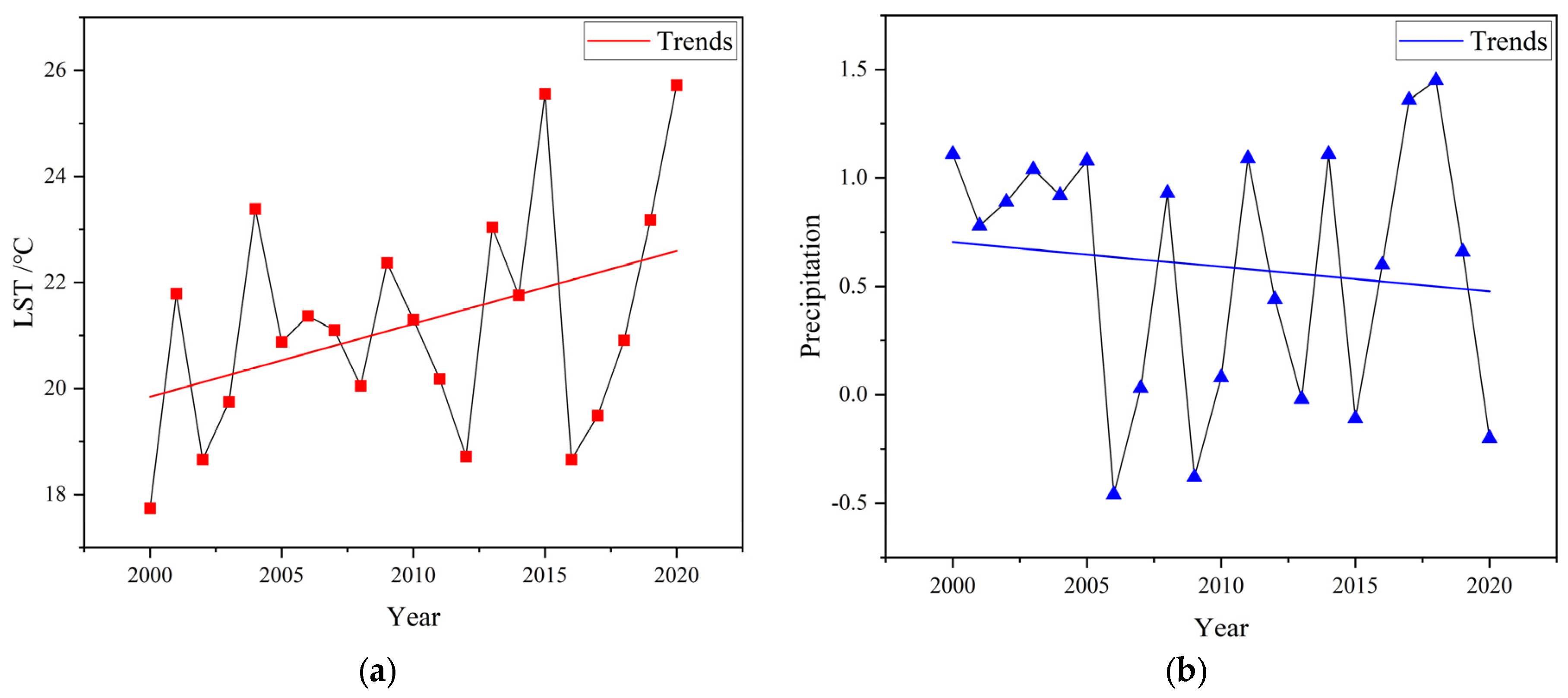
3.2. Analysis of Temporal Changes in the Quality of the Ecological Environment

To further investigate the changes in the local ecological conditions, the normalized RSEI ecological index was divided into five levels according to the 0.2 value interval, from low to high; excellent: 0.8–1.0; good: 0.6–0.8; moderate: 0.4–0.6; fair: 0.2–0.4; poor: 0–0.2.
Figure 3 illustrates the overall ecological quality of the Changtang Nature Reserve in the period of 2000–2020, as measured by the RSEI. The results indicate that the ecological environment was generally at a low level during this time frame. Specifically, there was a significant increase in the area characterized as a “poor” ecological environment from 2000 to 2010, suggesting a decline in the ecological conditions. However, from 2010 to 2020, there was a noticeable reduction in the area with a “poor” ecological environment, accompanied by an increase in the categories of “moderate,” “good,” and “excellent,” indicating an improvement in the ecological conditions.
Table 3 presents the area distribution of RSEI categories in the Changtang Nature Reserve over the past 20 years. The results indicate that the “excellent” category has the smallest proportion, accounting for less than 1% of the total area. The majority of the area is consistently classified as either “fair” or “poor” throughout each year, with both categories accounting for over 80% of the total area.
To provide a more visual representation of the changes in the Changtang Nature Reserve from 2000 to 2020 (Figure 4):
Over the past two decades, the average RSEI value in the Changtang Nature Reserve has exhibited a fluctuating trend of decrease followed by an increase, indicating a pattern of both deteriorating and improving ecological conditions. Specifically, from 2000 to 2010, the RSEI mean decreased from 0.3197 to 0.2269, reflecting a deterioration in the ecological environment. However, from 2010 to 2020, the RSEI mean increased from 0.2269 to 0.3180, indicating an improvement in the ecological environment.
Table 3 illustrates that from 2000 to 2010, the overall ecological environment in the reserve exhibited a declining trend. Specifically, the proportion of areas classified as fair and poor increased by 51.99%, while the proportion of areas classified as good and excellent decreased by 32.69%. However, from 2010 to 2020, the overall ecological environment in the reserve displayed an upward trend. During this period, the proportion of areas classified as good and excellent increased by 6.11%, while the proportion of areas classified as fair and poor decreased by 2.91%. Examining the three distinct functional zones, Figure 5 demonstrates that the ecological environment in the core zone consistently surpassed that of the buffer and experiment zones. The core zone exhibited minimal changes in the ecological environment and was nearly devoid of the poor level. From 2005 to 2010, there was a slight decrease in the ecological environment, followed by a slight increase from 2010 to 2015. The ecological environment in the buffer zone exhibited regional variation. Between 2000 and 2005, the southern part of the buffer zone experienced a more pronounced deterioration compared to the northern part. However, from 2005 to 2010, the ecological environment in the northern part showed a more significant decline than in the southern part, while the overall ecological environment improved from 2010 to 2015. The areas classified as poor in terms of RSEI level were primarily concentrated in the experiment zone, which displayed considerable variation in ecological conditions. From 2000 to 2005, there was a slight decrease in the ecological environment in the eastern part of the experiment zone, while from 2005 to 2010, there was a slight decrease in the western part and a slight increase in the eastern part. Overall, the ecological environment improved from 2010 to 2015.

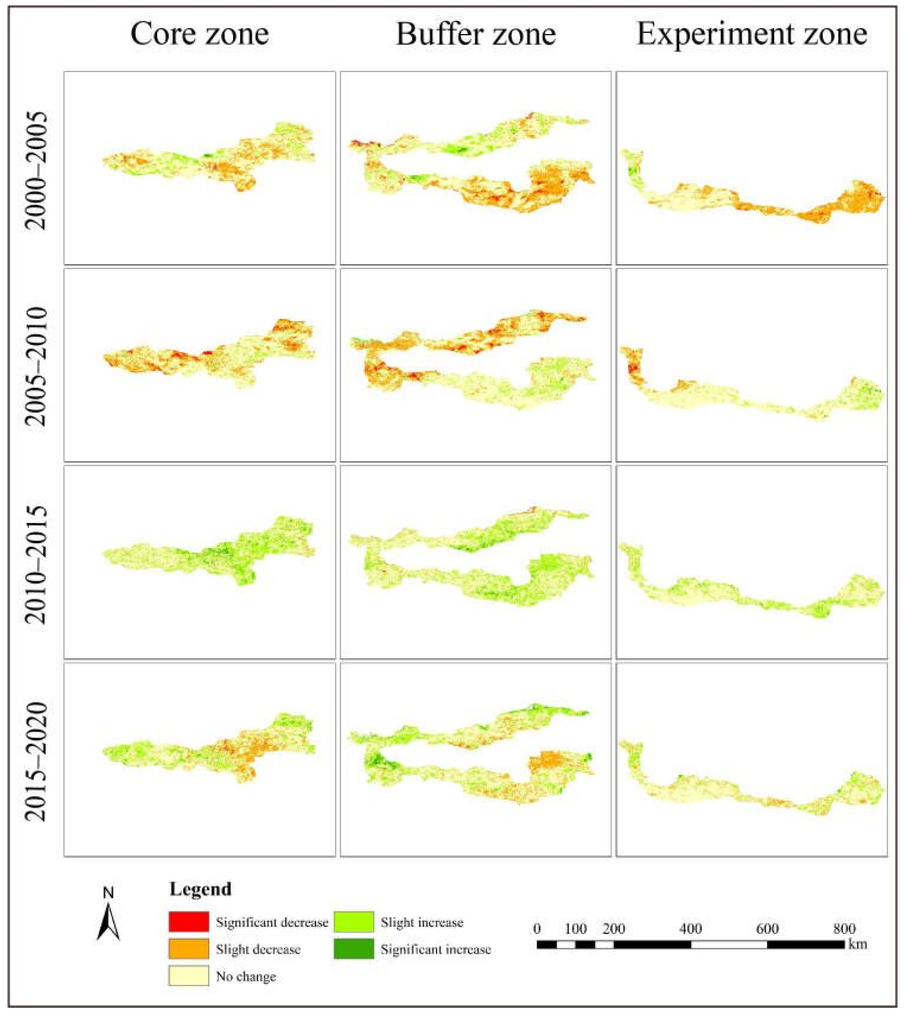
3.3. RSEI Transfer Analysis

To further investigate the changes in the local ecological conditions, we employed a transition matrix analysis to examine the dynamics of the ecological environment. The transition matrix provides a comprehensive perspective on the shifts between different ecological states over time. Through the analysis of the transition matrix, our aim is to uncover the underlying dynamics of the ecological environment in the Changtang Nature Reserve.
Table 4 reveals the following changes in the ecological environment during the period from 2000 to 2005. The Fair level experienced the largest area change, with an extensive conversion of 85,664.75 km2 from Fair to Poor. On the other hand, the Excellent level had the smallest area change, with only 3470.75 km2, but it exhibited the highest change rate, particularly with 90.01% transitioning from Excellent to Good and Moderate levels. The area transitioning from Moderate to Fair was substantial, reaching 35,698.25 km2, with a conversion rate of 56.65%. The Good to Moderate transition covered an area of 5740 km2, with a conversion rate of 51.35%. The changes in the Poor level were relatively minor, with the highest conversion rate observed as 22.57% transitioning to the Fair level. All these findings indicate a decreasing trend in the ecological environment from 2000 to 2005.
Table 5 presents the ecological changes observed from 2005 to 2010. The Fair level experienced the most substantial area transformation, with a considerable conversion of 71,197.75 km2 from Fair to Poor. Conversely, the Excellent level had the smallest area alteration, spanning a mere 245.5 km2; nevertheless, it displayed a noteworthy change rate of 89.35%. Notably, the conversion from Excellent to Moderate level accounted for 114.75 km2. The transition from Moderate to Fair covered a significant area of 32,049.75 km2, with a conversion rate of 61.71%. The Good to Fair transition encompassed 2903 km2, exhibiting a conversion rate of 45.40%. Similarly, the changes in the Poor level were relatively minor, with the highest conversion rate observed as 23.32% transitioning to the Fair level. Collectively, these findings indicate a declining trend in the ecological environment from 2005 to 2010.
Table 6 illustrates the changes in the ecological environment from 2010 to 2015. The Poor level exhibited the most substantial area transformation, with a significant conversion of 114,059 km2 from Poor to Fair. On the other hand, the Fair level had the smallest area change. Although there was a decreasing trend observed in the Moderate, Good, and Excellent levels, the transition from Fair to Moderate covered a considerable area of 39,823 km2. Overall, these findings indicate an increasing trend in the ecological environment from 2010 to 2015.
Furthermore, upon scrutinizing the ecological environment from 2015 to 2020, significant alterations can be discerned based on the data presented in Table 7. Notably, the Fair level underwent the most substantial spatial transformation, witnessing a considerable conversion of 37,880 km2 from Fair to Moderate. Simultaneously, a substantial area change of 31,430.5 km2 occurred in the opposite direction, transitioning from Poor to Fair. Although Moderate, Good, and Excellent levels exhibited a declining pattern, the comprehensive analysis of the ecological environment from 2015 to 2020 reveals an overall increasing trend.

4. Discussion

The PCA results of this study indicate that the Greenness Index (NDVI) and Wetness Index (WET) have a positive impact on RSEI, while the Dryness Index (SI) and Heat Index (LST) have a negative impact on RSEI. These findings are consistent with previous research [29,45]. The RSEI results reveal the average values of RSEI in the Changtang National Nature Reserve from 2000 to 2020, which are 0.3197, 0.2669, 0.02269, 0.3029, and 0.3180. We discuss the drivers of RSEI dynamics in the Changtang Nature Reserve, including LUCC, temperature, precipitation, and other factors.
Understanding the spatiotemporal changes in land cover is of paramount importance in comprehending the distribution characteristics of the RSEI and analyzing the underlying factors that influence it [45]. The findings from this study illuminate the significant role of land cover dynamics in shaping the patterns of RSEI. However, due to the extremely harsh natural environment in the study area, there is a lack of scientific investigations and limited availability of foundational data. Liu et al. [62] evaluated the accuracy of seven large-scale land cover datasets in the cold and arid region of the Changtang Plateau, indicating that the quality and accuracy of land cover data in the plateau area are low and need to be improved urgently. Moreover, Field surveys and available records suggest that grassland, desert, and bare land are the primary land cover types in the Changtang Plateau, with grassland being the predominant type. Grasslands are mainly distributed in the central and southern regions, deserts are primarily found in the northern region, and bare land is concentrated in the transition zone between grassland and desert in the northwest. Moreover, the unique plateau environment of the Changtang Plateau significantly influences land cover extraction. The vegetation growing season in the plateau is much shorter than in lower altitude regions [63,64], primarily occurring during the summer months. It is challenging to monitor vegetation type information during other months, and the land cover data may be obtained from images captured during different months. Using remote sensing imagery from non-growing seasons may lead to reduced accuracy in interpreting vegetation types. Therefore, due to the lack of foundational data in the Changtang Plateau, it is difficult to analyze the reasons for RSEI changes in the study area based on land use and land cover change analysis. In future research, addressing these challenges and limitations will be essential. Efforts should be made to improve the quality and availability of foundational data for the Changtang Plateau, including more comprehensive field investigations and the development of reliable and high-resolution land cover datasets specifically tailored to the unique characteristics of the plateau environment.
In the research area, temperature is influenced by multiple factors, and both temperature and precipitation exhibited gradual increases with fluctuations (Figure 6). Figure 6a presents the average temperature variation trend in the Qinghai-Tibet Plateau from 2000 to 2020. Overall, a rising temperature trend was observed, with the year 2000 recording the lowest temperature. This finding aligns with prior ecological research conducted in the Tibet Plateau [64]. Despite annual fluctuations, precipitation showed a long-term increasing trend (Figure 6b). This observation is consistent with the research findings of Du Jun et al. [3], who reported a significant annual temperature increase at meteorological stations near the nature reserve, with a rate of 0.46 °C per decade from 1971 to 2017. This rate surpasses the warming trend observed in global and Asian surface temperatures. The decrease in precipitation and the rise in surface temperature exhibit a synergistic effect, which is also reflected in the components of RSEI. Specifically, the decline in the wetness index is accompanied by an increase in the heat index, further influencing the ecological dynamics of the study area.
On the other hand, experimental results demonstrate that the ecological environment in the Core Zone exhibits a smaller magnitude of changes, possibly due to the prohibition of access by any organization or individual, thereby minimizing anthropogenic disturbances. In contrast, the Experimental Zone shows noticeable variations. Although it was designated as an autonomous regional nature reserve in 1993 and upgraded to a national-level reserve in 2001, the socio-economic development and expansion of human settlements have contributed to changes in the Changtang Nature Reserve. From 1988 to 2010, the total population in the six counties within the reserve increased from 55,900 to 138,700, with an average annual population growth rate of 4.22%, surpassing the population growth rate of Tibet. Human activities such as logging, grazing, and land cultivation within the protected area have resulted in ecological degradation. To address these issues, a series of measures were implemented for the establishment of the Changtang Nature Reserve system in 2015, including the establishment of 76 conservation stations. Additionally, to regulate the protection of the Changtang National Nature Reserve in Tibet, the management bureaus of Altun Mountain National Nature Reserve in Xinjiang, Kekexili National Nature Reserve in Qinghai, and Changtang National Nature Reserve in Tibet jointly issued a public notice prohibiting illegal trespassing activities in these reserves. These initiatives may contribute to the restoration of the ecological environment in the region between 2015 and 2020. However, RSEI is a comprehensive evaluation index, and due to the unique characteristics of the study area, it is challenging to determine the relative impact of each individual index on RSEI. This aspect indeed represents a future research direction.
Currently, the construction of RSEI based on MODIS remote sensing data sources is widely utilized. Despite the lower spatial resolution of MODIS data, which may result in the loss of fine details and mixing effects, it offers advantages over Landsat in terms of handling large-scale, long-term studies. However, compared to traditional image processing tools such as ENVI, the GEE enables rapid batch processing of a large number of images, effectively addressing the challenges of applying RSEI to extensive areas. Nevertheless, GEE excels in handling image data; it often encounters memory limitations when performing PCA calculations within RSEI. Therefore, many current studies choose MODIS as the data source for RSEI calculations in large-scale, long-term analyses and have demonstrated its effectiveness. These considerations highlight the trade-offs between spatial resolution and data volume, and the choice of data source depends on the specific research objectives and study area characteristics. Future research can explore methods to integrate data from multiple sources or explore alternative data processing techniques to further enhance the accuracy and applicability of RSEI in capturing detailed ecological information. While this method has demonstrated some effectiveness in assessing the spatiotemporal changes in ecological quality, it still has certain limitations. The RSEI-based evaluation method primarily focuses on measures of greenness, wetness, heat, and dryness. To enhance the representativeness of indicators for regional ecological quality, future research can consider incorporating additional indices. Lastly, although potential reasons are provided for the issues mentioned in the study, the lack of field measurements in the area necessitates further investigation to ascertain specific causes. It is hoped that these concerns will be addressed in future research endeavors.

5. Conclusions

This study employed remote sensing technology and satellite data to assess the ecological environment of the Chang Tang Nature Reserve By constructing the RSEI and analyzing its temporal and spatial variations. The results demonstrate that the overall ecological environment quality in the Chang Tang Nature Reserve was relatively poor from 2000 to 2020. However, there were fluctuating trends indicating both degradation and subsequent improvement in ecological environment quality. Spatially, the core zone exhibited higher ecological environment quality compared to the experimental and buffer zones, highlighting the need for enhanced protection measures in these zones. The comprehensive and accurate ecological information generated in this study can serve as a scientific basis for the management and conservation of the Chang Tang Nature Reserve.
The integration of remote sensing technology and RSEI offers an effective approach for monitoring and assessing ecological conditions over large spatial scales. These findings have significant implications for decision-making processes and support the development of sustainable practices in the reserve. Moreover, the application of remote sensing technology in evaluating ecological environment quality extends beyond the Chang Tang Nature Reserve, demonstrating its potential for global use. The comprehensive and precise ecological information generated by our research serves as a scientific basis for the management and conservation of not only the Chang Tang Nature Reserve but also other similar protected areas worldwide. Additionally, the findings of this study have worldwide importance, as they enhance our understanding of ecological dynamics and provide valuable insights for management, decision-making, and conservation strategies not only in the Chang Tang Nature Reserve but also in other similar ecosystems around the world.

Author Contributions

Conceptualization, X.P., S.Z. and M.B.; methodology, X.P., S.Z. and M.B.; software, M.B.; validation, S.Z. and M.B.; formal analysis, M.B., S.Z., J.W. and Y.L.; resources, S.Z., M.B. and P.P.; data curation, A.C.; writing—original draft preparation, S.Z., M.B. and Y.L.; writing—review and editing, X.P., S.Z., M.B. and A.C.; visualization, X.P., M.B. and S.Z.; supervision, P.P., S.Z., J.W. and M.B.; project administration, P.P., J.W. and S.Z. All authors have read and agreed to the published version of the manuscript.

Funding

This research was supported by the Second National Survey of Key Protected Wild Plant Resources-Special Survey of Orchidaceae in Sichuan Province (No.80303-AZZ003); the Special Project of Orchid Survey of National Forestry and Grassland Administration (No.2019073015); the Second Tibetan Plateau Scientific Expedition and Research Program (STEP), China (No.2019QZKK0301).

Data Availability Statement

Data sharing is not applicable. No new data were created or analyzed in this study. Data sharing is not applicable to this article.

Conflicts of Interest

The authors declare no conflict of interest.

Appendix A

Table A1. MODIS image series data of the Changtang Nature Reserve from 2000 to 2020.
YearSensorsAcquisition Date
2000MOD09A1
MOD11A2
3 July 2000; 11 July 2000; 19 July 2000; 27 July 2000; 4 August 2000; 12 August 2000; 20 August 2000; 28 August 2000; 5 September 2000; 13 September 2000; 21 September 2000; 29 September 2000
MOD13A111 July 2000; 27 July 2000; 12 August 2000; 28 August 2000; 13 September 2000; 29 September 2000
2005MOD09A1
MOD11A2
4 July 2000; 12 July 2000; 20 July 2000; 28 July 2000; 5 August 2000; 13 August 2000; 21 August 2000; 29 August 2000; 6 September 2000; 14 September 2000; 22 September 2000
MOD13A112 July 2000; 28 July 2000; 13 August 2000; 29 August 2000; 14 September 2000
2010MOD09A1
MOD11A2
4 July 2000; 12 July 2000; 20 July 2000; 28 July 2000; 5 August 2000; 13 August 2000; 21 August 2000; 29 August 2000; 6 September 2000; 14 September 2000; 22 September 2000
MOD13A112 July 2000; 28 July 2000; 13 August 2000; 29 August 2000; 14 September 2000
2015MOD09A1
MOD11A2
4 July 2000; 12 July 2000; 20 July 2000; 28 July 2000; 5 August 2000; 13 August 2000; 21 August 2000; 29 August 2000; 6 September 2000; 14 September 2000; 22 September 2000
MOD13A112 July 2000; 28 July 2000; 13 August 2000; 29 August 2000; 14 September 2000
2020MOD09A1
MOD11A2
3 July 2000; 11 July 2000; 19 July 2000; 27 July 2000; 4 August 2000; 4 August 2000; 12 August 2000; 20 August 2000; 28 August 2000; 5 September 2000; 13 September 2000; 21 September 2000; 29 September 2000
MOD13A111 July 2000; 27 July 2000; 12 August 2000; 28 August 2000; 13 September 2000; 29 September 2000
Choi, Mihwa. 2008. Contesting Imaginaires in Death Rituals during the Northern Song Dynasty. Master thesis, Beijing Forestry University, Beijing, China, 1 December.

References

  1. Liangliang, Y. The Geographic Characteristics Analysis of the National Key Protected Vertebrates and National Nature Reserves in China. Master’s Thesis, Beijing Forestry University, Beijing, China, 1 December 2009. [Google Scholar]
  2. Xiaoping, W.; Wunian, Y.; Guoming, L. Research on NDVl temporal and spatial variation of Qiangtang National Nature Reserve. Sci. Surv. Mapp. 2014, 85, 2071–2079. [Google Scholar] [CrossRef]
  3. Jun, D.; Xiaojun, N.; Lei, Y.; Dunzhu, C. Climatic and environmental features in Chang Tang National Nature Reserve during 1971–2017. J. Glaciol. Geocryol. 2020, 42, 1017–1026. [Google Scholar]
  4. Wang, R.; Feng, Q.; Jin, Z.; Liang, T. The restoration potential of the grasslands on the tibetan plateau. Remote Sens. 2022, 14, 80. [Google Scholar] [CrossRef]
  5. Yang, L.; Zhao, G.; Mu, X.; Lan, Z.; Jiao, J.; An, S.; Wu, Y.; Miping, P. Integrated assessments of land degradation on the Qinghai-Tibet plateau. Ecol. Indic. 2023, 147, 109945. [Google Scholar] [CrossRef]
  6. Li, M.; Weng, B.; Yan, D.; Bi, W.; Wang, H. Variation trends and attribution analysis of lakes in the Qiangtang Plateau, the Endorheic Basin of the Tibetan Plateau. Sci. Total Environ. 2022, 837, 155595. [Google Scholar] [CrossRef] [PubMed]
  7. Dunzhu, C.; Jun, D.; Cuojie, D. Spatial-temporal Change of Consecutive Dry Days in Changtang National Nature Reserve of Tibet During 1971–2017. Chin. Agric. Sci. Bull. 2018, 34, 118–122. [Google Scholar]
  8. Jun, Z.; Lei, S.; Dunzhu, C. Response of Snow Cover to Climate Change in Chang Tang Nature Reserve in 1971–2017. Chin. Agric. Sci. Bull. 2019, 35, 130–138. [Google Scholar]
  9. Jun, D.; Kanshe, Z.; Duzhu, C. Spatial and temporal variations of surface soil freezing days in Chang Tang Natural Reserve of Tibet during 1981–2018. Chin. J. Ecol. 2020, 39, 1121–1129. [Google Scholar]
  10. Lei, Y.; Kanshe, Z.; Dongdong, Z. Spatial-temporal Variation of NDVI in the Vegetation Growing Season of Changtang National Nature Reserve and Its Response to Climate Change. Chin. Agric. Sci. Bull. 2022, 38, 127–134. [Google Scholar]
  11. Urban, M.; Eberle, J.; Hüttich, C.; Schmullius, C.; Herold, M. Comparison of satellite-derived land surface temperature and air temperature from meteorological stations on the pan-arctic scale. Remote Sens. 2013, 5, 2348–2367. [Google Scholar] [CrossRef] [Green Version]
  12. Wang, F.; Yang, H.; Wang, Z.; Zhang, Z.; Li, Z. Drought evaluation with CMORPH satellite precipitation data in the Yellow River basin by using Gridded Standardized Precipitation Evapotranspiration Index. Remote Sens. 2019, 11, 485. [Google Scholar] [CrossRef] [Green Version]
  13. Ramírez-Cuesta, J.M.; Cruz-Blanco, M.; Santos, C.; Lorite, I.J. Assessing reference evapotranspiration at regional scale based on remote sensing, weather forecast and GIS tools. Int. J. Appl. Earth Obs. Geoinf. 2017, 55, 32–42. [Google Scholar] [CrossRef]
  14. Wang, F.; Wang, Z.; Yang, H.; Zhao, Y.; Li, Z.; Wu, J. Capability of remotely sensed drought indices for representing the spatio-temporal variations of the meteorological droughts in the Yellow River basin. Remote Sens. 2018, 10, 1834. [Google Scholar] [CrossRef] [Green Version]
  15. Sishodia, R.P.; Ray, R.L.; Singh, S.K. Applications of remote sensing in precision agriculture: A review (Indices vegetativos utilizados na agricultura). Remote Sens. 2020, 12, 3136. [Google Scholar] [CrossRef]
  16. Maurya, K.; Mahajan, S.; Chaube, N. Remote sensing techniques: Mapping and monitoring of mangrove ecosystem—A review. Complex Intell. Syst. 2021, 7, 2797–2818. [Google Scholar] [CrossRef]
  17. Shiklomanov, A.N.; Bradley, B.A.; Dahlin, K.M.; Fox, A.M.; Gough, C.M.; Hoffman, F.M.; Middleton, E.M.; Serbin, S.P.; Smallman, L.; Smith, W.K. Enhancing global change experiments through integration of remote-sensing techniques. Front. Ecol. Environ. 2019, 17, 215–224. [Google Scholar] [CrossRef] [Green Version]
  18. Pettorelli, N.; Schulte to Bühne, H.; Tulloch, A.; Dubois, G.; Macinnis-Ng, C.; Queirós, A.M.; Keith, D.A.; Wegmann, M.; Schrodt, F.; Stellmes, M.; et al. Satellite remote sensing of ecosystem functions: Opportunities, challenges and way forward. Remote Sens. Ecol. Conserv. 2018, 4, 71–93. [Google Scholar] [CrossRef]
  19. Song, Y.; Wu, C. Examining human heat stress with remote sensing technology. GIScience Remote Sens. 2018, 55, 19–37. [Google Scholar] [CrossRef]
  20. Murray, N.J.; Keith, D.A.; Bland, L.M.; Ferrari, R.; Lyons, M.B.; Lucas, R.; Pettorelli, N.; Nicholson, E. The role of satellite remote sensing in structured ecosystem risk assessments. Sci. Total Environ. 2018, 619–620, 249–257. [Google Scholar] [CrossRef] [Green Version]
  21. Eddy, I.M.S.; Gergel, S.E.; Coops, N.C.; Henebry, G.M.; Levine, J.; Zerriffi, H.; Shibkov, E. Integrating remote sensing and local ecological knowledge to monitor rangeland dynamics. Ecol. Indic. 2017, 82, 106–116. [Google Scholar] [CrossRef]
  22. Li, K.; Zhang, B.; Xiao, W.; Lu, Y. Land Use Transformation Based on Production−Living−Ecological Space and Associated Eco-Environment Effects: A Case Study in the Yangtze River Delta Urban Agglomeration. Land 2022, 11, 1076. [Google Scholar] [CrossRef]
  23. Yang, Y.; Wang, L.; Yang, F.; Hu, N.; Liang, L. Evaluation of the coordination between eco-environment and socioeconomy under the “Ecological County Strategy” in western China: A case study of Meixian. Ecol. Indic. 2021, 125, 107585. [Google Scholar] [CrossRef]
  24. Wang, Z.; Chen, T.; Zhu, D.; Jia, K.; Plaza, A. RSEIFE: A new remote sensing ecological index for simulating the land surface eco-environment. J. Environ. Manag. 2023, 326, 116851. [Google Scholar] [CrossRef]
  25. Peng, J.; Zhao, Z.; Yin, G. Evaluation of urban land resource value based on sustainable environment space governance. Alex. Eng. J. 2022, 61, 5585–5593. [Google Scholar] [CrossRef]
  26. Wang, J.; Li, G. Eco-Environmental Effect Evaluation of Tamarix chinesis Forest on Coastal Saline-Alkali Land Based on RSEI Model. Sens. Artic. 2022, 22, 5052. [Google Scholar] [CrossRef]
  27. Geng, J.; Yu, K.; Xie, Z.; Zhao, G.; Ai, J.; Yang, L.; Yang, H.; Liu, J. Analysis of Spatiotemporal Variation and Drivers of Ecological Quality in Fuzhou Based on RSEI. Remote Sens. 2022, 14, 4900. [Google Scholar] [CrossRef]
  28. Yang, X.; Meng, F.; Fu, P.; Wang, Y.; Liu, Y. Time-frequency optimization of RSEI: A case study of Yangtze River Basin. Ecol. Indic. 2022, 141, 109080. [Google Scholar] [CrossRef]
  29. Yuan, B.; Fu, L.; Zou, Y.; Zhang, S.; Chen, X.; Li, F.; Deng, Z.; Xie, Y. Spatiotemporal change detection of ecological quality and the associated affecting factors in Dongting Lake Basin, based on RSEI. J. Clean. Prod. 2021, 302, 126995. [Google Scholar] [CrossRef]
  30. Jiang, F.; Zhang, Y.; Li, J.; Sun, Z. Research on remote sensing ecological environmental assessment method optimized by regional scale. Environ. Sci. Pollut. Res. 2021, 28, 68174–68187. [Google Scholar] [CrossRef]
  31. Li, J.; Liang, J.; Wu, Y.; Yin, S.; Yang, Z.; Hu, Z. Quantitative evaluation of ecological cumulative effect in mining area using a pixel-based time series model of ecosystem service value. Ecol. Indic. 2021, 120, 106873. [Google Scholar] [CrossRef]
  32. Fan, M.; Liao, K.; Lu, D.; Li, D. Examining Vegetation Change and Associated Spatial Patterns in Wuyishan National Park at Different Protection Levels. Remote Sens. 2022, 14, 1712. [Google Scholar] [CrossRef]
  33. Zheng, Z.; Wu, Z.; Chen, Y.; Guo, C.; Marinello, F. Instability of remote sensing based ecological index (RSEI) and its improvement for time series analysis. Sci. Total Environ. 2022, 814, 152595. [Google Scholar] [CrossRef]
  34. Hird, J.N.; McDermid, G.J. Noise reduction of NDVI time series: An empirical comparison of selected techniques. Remote Sens. Environ. 2009, 113, 248–258. [Google Scholar] [CrossRef]
  35. Dong, X.; Liu, B.; Yang, L.; Wang, H.; Wu, B.; Liu, R.; Chen, H.; Chen, X.; Yu, S.; Chen, B.; et al. Clinical exome sequencing as the first-tier test for diagnosing developmental disorders covering both CNV and SNV: A Chinese cohort. J. Med. Genet. 2020, 57, 558–566. [Google Scholar] [CrossRef] [Green Version]
  36. Sajadi, P.; Sang, Y.F.; Gholamnia, M.; Bonafoni, S.; Brocca, L.; Pradhan, B.; Singh, A. Performance evaluation of long ndvi timeseries from avhrr, modis and landsat sensors over landslide-prone locations in qinghai-tibetan plateau. Remote Sens. 2021, 13, 3172. [Google Scholar] [CrossRef]
  37. Liu, R.; Shang, R.; Liu, Y.; Lu, X. Global evaluation of gap-filling approaches for seasonal NDVI with considering vegetation growth trajectory, protection of key point, noise resistance and curve stability. Remote Sens. Environ. 2017, 189, 164–179. [Google Scholar] [CrossRef] [Green Version]
  38. Sakamoto, T.; Yokozawa, M.; Toritani, H.; Shibayama, M.; Ishitsuka, N.; Ohno, H. A crop phenology detection method using time-series MODIS data. Remote Sens. Environ. 2005, 96, 366–374. [Google Scholar] [CrossRef]
  39. Vuolo, F.; Ng, W.T.; Atzberger, C. Smoothing and gap-filling of high resolution multi-spectral time series: Example of Landsat data. Int. J. Appl. Earth Obs. Geoinf. 2017, 57, 202–213. [Google Scholar] [CrossRef]
  40. Julien, Y.; Sobrino, J.A. Comparison of cloud-reconstruction methods for time series of composite NDVI data. Remote Sens. Environ. 2010, 114, 618–625. [Google Scholar] [CrossRef]
  41. Chen, J.; Jönsson, P.; Tamura, M.; Gu, Z.; Matsushita, B.; Eklundh, L. A simple method for reconstructing a high-quality NDVI time-series data set based on the Savitzky-Golay filter. Remote Sens. Environ. 2004, 91, 332–344. [Google Scholar] [CrossRef]
  42. Mingwei, Z.; Qingbo, Z.; Zhongxin, C.; Jia, L.; Yong, Z.; Chongfa, C. Crop discrimination in Northern China with double cropping systems using Fourier analysis of time-series MODIS data. Int. J. Appl. Earth Obs. Geoinf. 2008, 10, 476–485. [Google Scholar] [CrossRef]
  43. Roerink, G.J.; Menenti, M.; Verhoef, W. Reconstructing cloudfree NDVI composites using Fourier analysis of time series. Int. J. Remote Sens. 2000, 21, 1911–1917. [Google Scholar] [CrossRef]
  44. Aizizi, Y.; Kasimu, A.; Liang, H.; Zhang, X.; Zhao, Y.; Wei, B. Evaluation of ecological space and ecological quality changes in urban agglomeration on the northern slope of the Tianshan Mountains. Ecol. Indic. 2023, 146, 109896. [Google Scholar] [CrossRef]
  45. Xiong, Y.; Xu, W.; Lu, N.; Huang, S.; Wu, C.; Wang, L.; Dai, F.; Kou, W. Assessment of spatial–temporal changes of ecological environment quality based on RSEI and GEE: A case study in Erhai Lake Basin, Yunnan province, China. Ecol. Indic. 2021, 125, 107518. [Google Scholar] [CrossRef]
  46. Liu, Z.; Wang, L.; Li, B. Quality Assessment of Ecological Environment Based on Google Earth Engine: A Case Study of the Zhoushan Islands. Front. Ecol. Evol. 2022, 10, 918756. [Google Scholar] [CrossRef]
  47. Yan, Y.; Zhuang, Q.; Zan, C.; Ren, J.; Yang, L.; Wen, Y.; Zeng, S.; Zhang, Q.; Kong, L. Using the Google Earth Engine to rapidly monitor impacts of geohazards on ecological quality in highly susceptible areas. Ecol. Indic. 2021, 132, 108258. [Google Scholar] [CrossRef]
  48. Klisch, A.; Atzberger, C. Operational drought monitoring in Kenya using MODIS NDVI time series. Remote Sens. 2016, 8, 267. [Google Scholar] [CrossRef] [Green Version]
  49. Crist, E.P. A TM Tasseled Cap equivalent transformation for reflectance factor data. Remote Sens. Environ. 1985, 17, 301–306. [Google Scholar] [CrossRef]
  50. Nichol, J. Remote sensing of urban heat islands by day and night. Photogramm. Eng. Remote Sens. 2005, 71, 613–621. [Google Scholar] [CrossRef]
  51. Liu, Y.; Meng, Q.; Zhang, L.; Wu, C. NDBSI: A normalized difference bare soil index for remote sensing to improve bare soil mapping accuracy in urban and rural areas. Catena 2022, 214, 106265. [Google Scholar] [CrossRef]
  52. Sur, K.; Dave, R.; Chauhan, P. Spatio—Temporal changes in NDVI and rainfall over Western Rajasthan and Gujarat region of India. J. Agrometeorol. 2018, 20, 189–195. [Google Scholar]
  53. Xu, H. Modification of normalised difference water index (NDWI) to enhance open water features in remotely sensed imagery. Int. J. Remote Sens. 2006, 27, 3025–3033. [Google Scholar] [CrossRef]
  54. Xie, F.; Fan, H. Deriving drought indices from MODIS vegetation indices (NDVI/EVI) and Land Surface Temperature (LST): Is data reconstruction necessary? Int. J. Appl. Earth Obs. Geoinf. 2021, 101, 102352. [Google Scholar] [CrossRef]
  55. Wan, W.; Liu, Z.; Li, K.; Wang, G.; Wu, H.; Wang, Q. Drought monitoring of the maize planting areas in Northeast and North China Plain. Agric. Water Manag. 2021, 245, 106636. [Google Scholar] [CrossRef]
  56. Abdi, H.; Williams, L.J. Principal component analysis. wiley interdisciplinary reviews: Computational statistics. Wiley Interdisplinary Rev. Comput. Stat. 2010, 2, 433–459. [Google Scholar] [CrossRef]
  57. Johnstone, I.M.; Paul, D. PCA in High Dimensions: An Orientation. Proc. IEEE 2018, 106, 1277–1292. [Google Scholar] [CrossRef]
  58. Xiu, Y.; Liu, W.; Yang, W. An Improved Rotation Forest for Multi-Feature Remote-Sensing Imagery Classification. Remote Sens. 2017, 9, 1205. [Google Scholar] [CrossRef] [Green Version]
  59. Gewers, F.L.; Ferreira, G.R.; De Arruda, H.F.; Silva, F.N.; Comin, C.H.; Amancio, D.R.; Costa, L.D.F. Principal component analysis: A natural approach to data exploration. ACM Comput. Surv. 2021, 54, 3447755. [Google Scholar] [CrossRef]
  60. Wakulinśka, M.; Marcinkowska-Ochtyra, A. Multi-temporal sentinel-2 data in classification of mountain vegetation. Remote Sens. 2020, 12, 2696. [Google Scholar] [CrossRef]
  61. Oteros, J.; García-Mozo, H.; Vázquez, L.; Mestre, A.; Domínguez-Vilches, E.; Galán, C. Modelling olive phenological response to weather and topography. Agric. Ecosyst. Environ. 2013, 179, 62–68. [Google Scholar] [CrossRef]
  62. Liu, Q.; Zhang, Y.; Liu, L.; Li, L.; Qi, W. The spatial local accuracy of land cover datasets over the Qiangtang Plateau, High Asia. J. Geogr. Sci. 2019, 29, 1841–1858. [Google Scholar] [CrossRef] [Green Version]
  63. Zhang, G.; Zhang, Y.; Dong, J.; Xiao, X. Green-up dates in the Tibetan Plateau have continuously advanced from 1982 to 2011. Proc. Natl. Acad. Sci. USA 2013, 110, 4309–4314. [Google Scholar] [CrossRef]
  64. Cao, J.; Wu, E.; Wu, S.; Fan, R.; Xu, L.; Ning, K.; Li, Y.; Lu, R.; Xu, X.; Zhang, J.; et al. Spatiotemporal Dynamics of Ecological Condition in Qinghai-Tibet Plateau Based on Remotely Sensed Ecological Index. Remote Sens. 2022, 14, 4234. [Google Scholar] [CrossRef]
Figure 1. The technical workflow of this study.
Land 12 01581 g001
Figure 2. Location of the study area.
Land 12 01581 g002
Figure 3. The RSEI maps of the study area from 2000 to 2020. (a) The RSEI maps of the study area in 2000. (b) The RSEI maps of the study area in 2005. (c) The RSEI maps of the study area in 2010. (d) The RSEI maps of the study area in 2015. (e) The RSEI maps of the study area in 2020.To further analyze the trend of RSEI variations in the study area, we conducted a comprehensive assessment by calculating the area and proportion of each RSEI category in different years. The detailed results are presented in Table 3. By examining the changes in RSEI over time, we can gain insights into the dynamics of the ecological environment within the research area.
Land 12 01581 g003
Figure 4. The RSEI changes in the Changtang Nature Reserve from 2000 to 2020.
Land 12 01581 g004
Figure 5. The RSEI changes in the different zones from 2000 to 2020.
Land 12 01581 g005
Figure 6. Land surface temperature and SPEI of the study area in 2000–2020. (a) Land surface temperature of the study area in 2000–2020. (b) The SPEI of the study area in 2000–2020.
Land 12 01581 g006
Table 1. The detailed information of Datasets.
DatasetsLevelSpatial Resolution (m)Temporal Resolution (d)Years
MOD13A1L3500 m162000, 2005,
2010, 2015,
2020
MOD11A2L31000 m8
MOD09A1L2500 m8
MCD12Q1L3500 m365
Table 2. The results of PCA.
YearIndicatorsPC1PC2PC3PC4
2000NDVI0.1106−0.79380.2869−0.5247
LST−0.10680.1225−0.7633−0.6252
WET0.5733−0.5373−0.39550.4756
SI−0.8048−0.2574−0.42250.3279
Eigenvalue0.04180.00870.00480.0000
Percent eigenvalue75.59%15.73%8.68%0%
2005NDVI0.1860−0.70740.6375−0.2422
LST−0.0715−0.3375−0.6519−0.6753
WET0.15880.61820.3868−0.6656
SI−0.9670−0.05950.1379−0.2059
Eigenvalue0.03280.00930.00260.0013
Percent eigenvalue71.30%20.22%5.65%2.83%
2010NDVI0.1288 −0.5945 −0.0486 −0.7922
LST−0.1548 0.4790 −0.7961 −0.3358
WET−0.2921 0.6446 0.5287 −0.4686
SI−0.9350 0.0402 0.2903 −0.2000
Eigenvalue0.03560.01000.00420.0000
Percent eigenvalue71.46%20.09%8.45%0%
2015NDVI0.0892 −0.5208 −0.2815 −0.8100
LST−0.1519 0.5811 −0.7909 −0.1168
WET0.1378 0.6233 0.5159 −0.5713
SI−0.9747 −0.0501 0.1704 −0.1359
Eigenvalue0.04410.00450.00370.0000
Percent eigenvalue84.40%8.54%7.06%0%
2020NDVI0.1517 −0.7458 0.3500 −0.5461
LST−0.0332 −0.0752 −0.8789 −0.4698
WET0.2085−0.6613−0.28850.6603
SI−0.9656−0.0282−0.14750.2122
Eigenvalue0.03880.00270.00450.0000
Percent eigenvalue84.35%5.87%9.78%0%
Table 3. Area of each RSEI level in different years.
RSEI Level20002005201020152020
Area (km2)Pct. (%)Area (km2)Pct. (%)Area (km2)Pct. (%)Area (km2)Pct. (%)Area (km2)Pct. (%)
Poor59,46416.40%134,978.2537.24%184,808.550.98%64,869.517.90%64,869.517.90%
Fair225,19962.13%168,907.7546.60%157,10443.34%222,360.7561.34%222,360.7561.34%
Moderate63,02117.39%51,935.7514.33%14,565.754.02%66,235.518.27%66,235.518.27%
Good11,178.753.08%6393.751.76%4601.751.27%77112.13%77112.13%
Excellent3627.51.00%274.750.08%1410.250.39%1313.50.36%1313.50.36%
Table 4. Change detection of RSEI level from 2000–2005.
2000
PoorFairModerateGoodExcellent
Area (km2)Pct. (%)Area (km2)Pct. (%)Area (km2)Pct. (%)Area (km2)Pct. (%)Area (km2)Pct. (%)
2005Poor45,035.7575.7485,664.7538.04 42646.7713.750.1200.00
Fair13,42022.57115,905.551.4735,698.2556.653682.2532.94201.755.56
Moderate970.51.6322,382.259.9421,094.7533.47574051.351748.2548.19
Good37.750.061225.50.541949.753.09166014.851520.7541.92
Excellent00.00210.0114.250.0282.750.74156.754.32
Change14,428.2524.26109,293.548.5341,926.2566.53 9518.7585.153470.7595.68
Table 5. Transfer matrix of RSEI level from 2005–2010.
2005
PoorFairModerateGoodExcellent
Area (km2)Pct. (%)Area (km2)Pct. (%)Area (km2)Pct. (%)Area (km2)Pct. (%)Area (km2)Pct. (%)
2010Poor103,05376.3571,197.7542.1510,232.7519.703255.0800.00
Fair31,481.2523.3290,62353.6532,049.7561.71290345.404717.11
Moderate421.750.315703.253.386658.512.821667.526.08114.7541.77
Good21.750.021249.50.742221.754.28102516.0383.7530.48
Excellent0.50.00134.250.087731.49473.257.4029.2510.65
Change31,925.2523.6578,284.7546.3545,277.2587.185368.7583.97245.589.35
Table 6. Transfer matrix of RSEI level from 2010–2015.
2010
PoorFairModerateGoodExcellent
Area (km2)Pct. (%)Area (km2)Pct. (%)Area (km2)Pct. (%)Area (km2)Pct. (%)Area (km2)Pct. (%)
2015Poor52,092.2528.1912,586.258.01185.51.275.50.1200.00
Fair114,05961.72101,867.564.845817.2539.9457912.58382.69
Moderate18,240.259.8739,82325.356288.7543.171646.2535.77237.2516.82
Good4170.232773.751.772081.514.29184740.14591.7541.96
Excellent00.0053.50.03192.751.3252411.39543.2538.52
Change132,716.371.8155,236.535.16827756.832754.7559.8686761.48
Table 7. Transfer matrix of RSEI level from 2015–2020.
2015
PoorFairModerateGoodExcellent
Area (km2)Pct. (%)Area (km2)Pct. (%)Area (km2)Pct. (%)Area (km2)Pct. (%)Area (km2)Pct. (%)
2020Poor31,021.2547.8230,303.7513.633012.254.5515.750.2000.00
Fair31,430.548.45147,767.866.4535,95554.281063.7513.8000.00
Moderate2241.753.4637,88017.0419,978.2530.162921.2537.8845.253.44
Good171.750.266077.752.736605.59.97298838.75536.2540.83
Excellent4.250.01331.50.15684.51.03722.259.3773255.73
Change33,848.2552.1874,59333.5546,257.2569.84472361.25581.544.27
Disclaimer/Publisher’s Note: The statements, opinions and data contained in all publications are solely those of the individual author(s) and contributor(s) and not of MDPI and/or the editor(s). MDPI and/or the editor(s) disclaim responsibility for any injury to people or property resulting from any ideas, methods, instructions or products referred to in the content.

