
Outdoor Thermal Comfort Study on a District Level as Part of the Housing Programs in Abu Dhabi and Al Ain, United Arab Emirates

Abstract
:1. Introduction
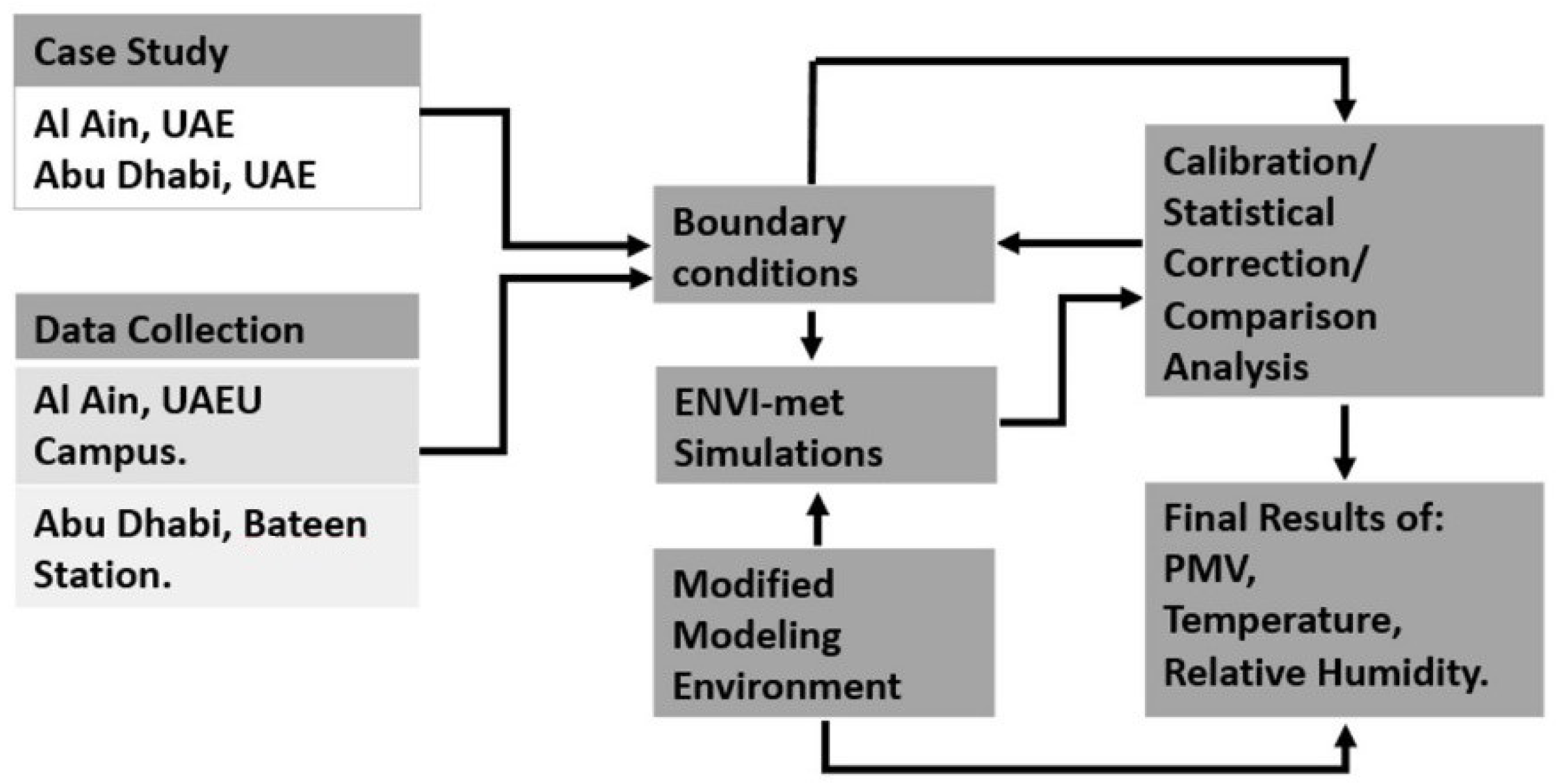
2. Methodology
- -
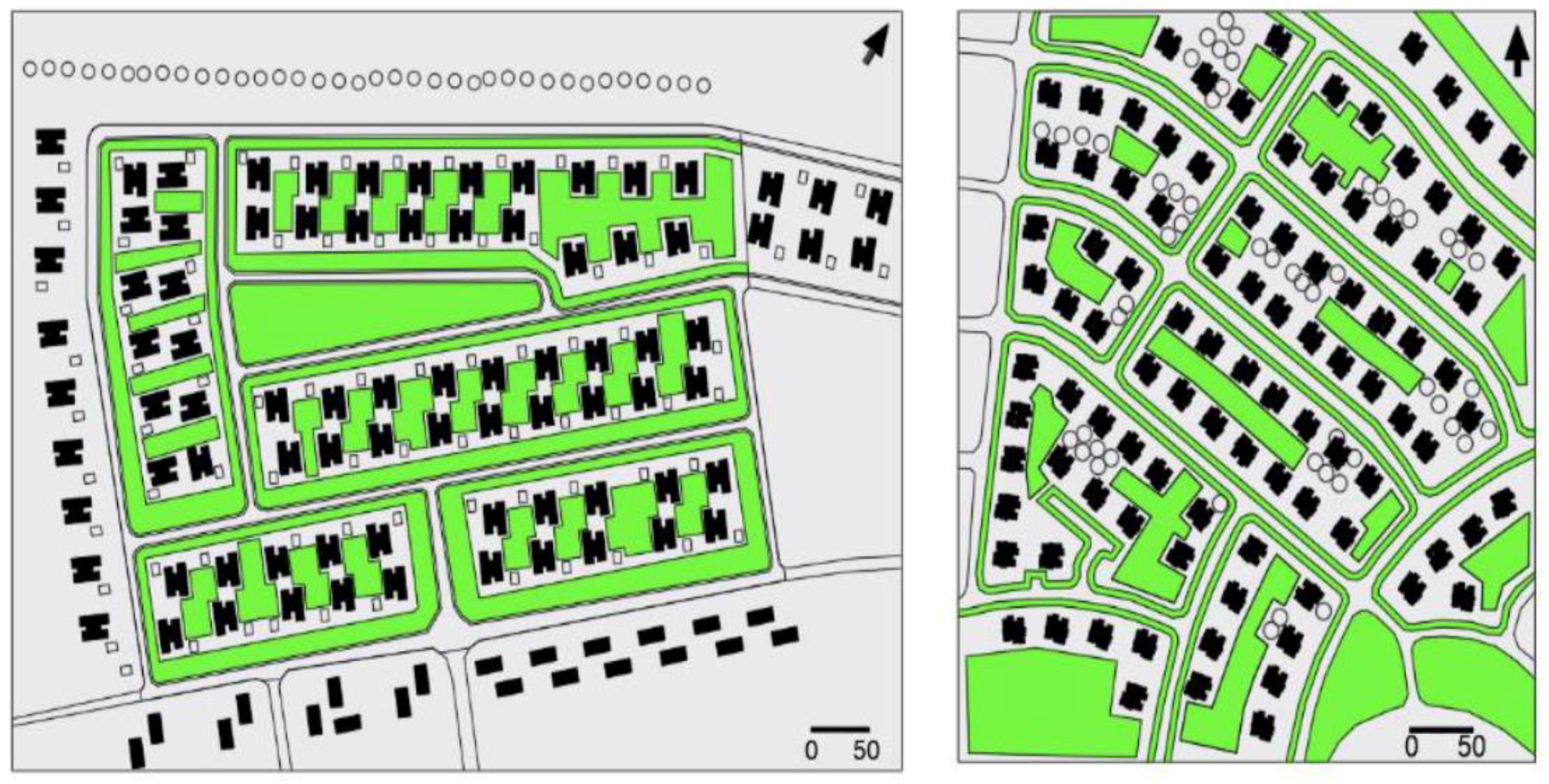
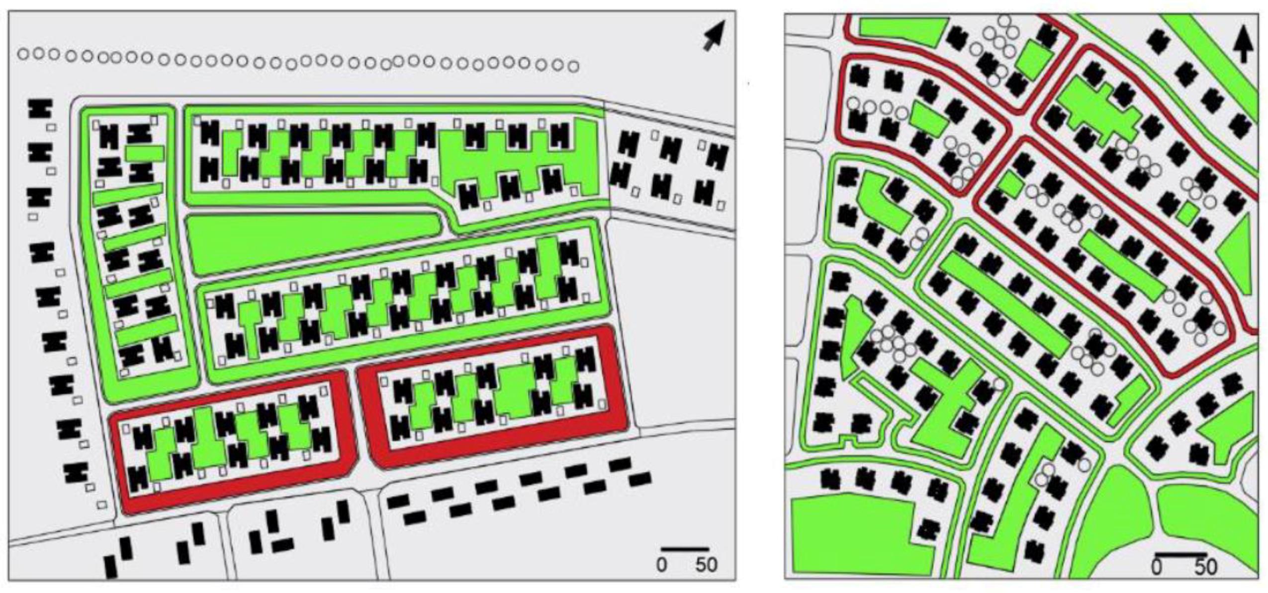
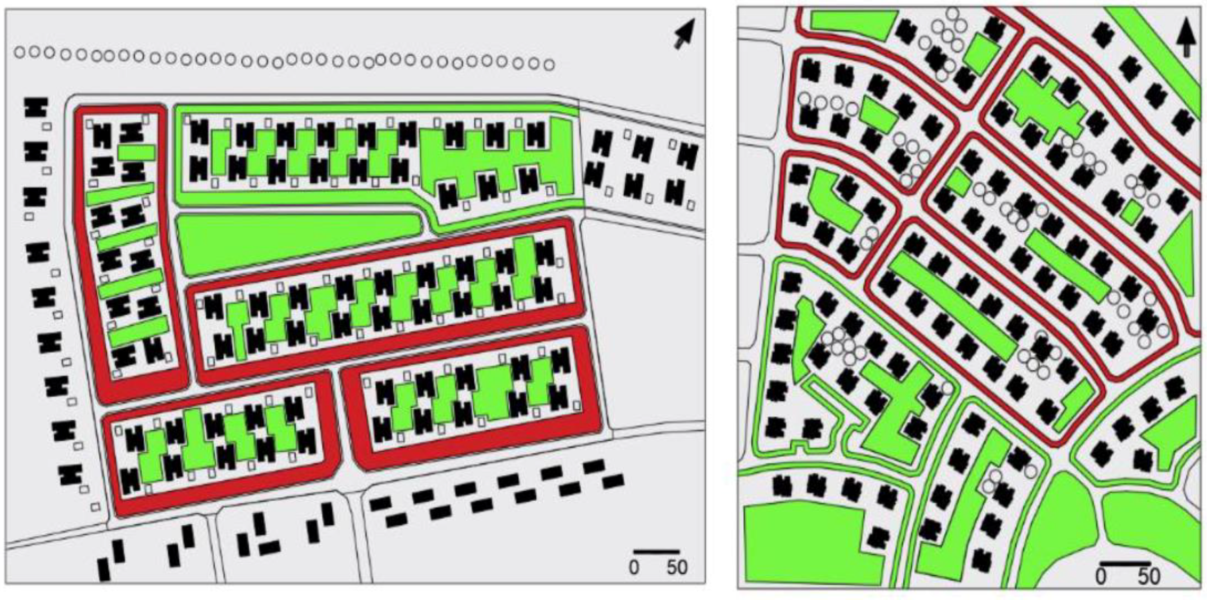
- District selection/scenario evaluation
- -
- Weather conditions
- -
- Site measurements
- -
- Modeling and simulations
- -
- Results
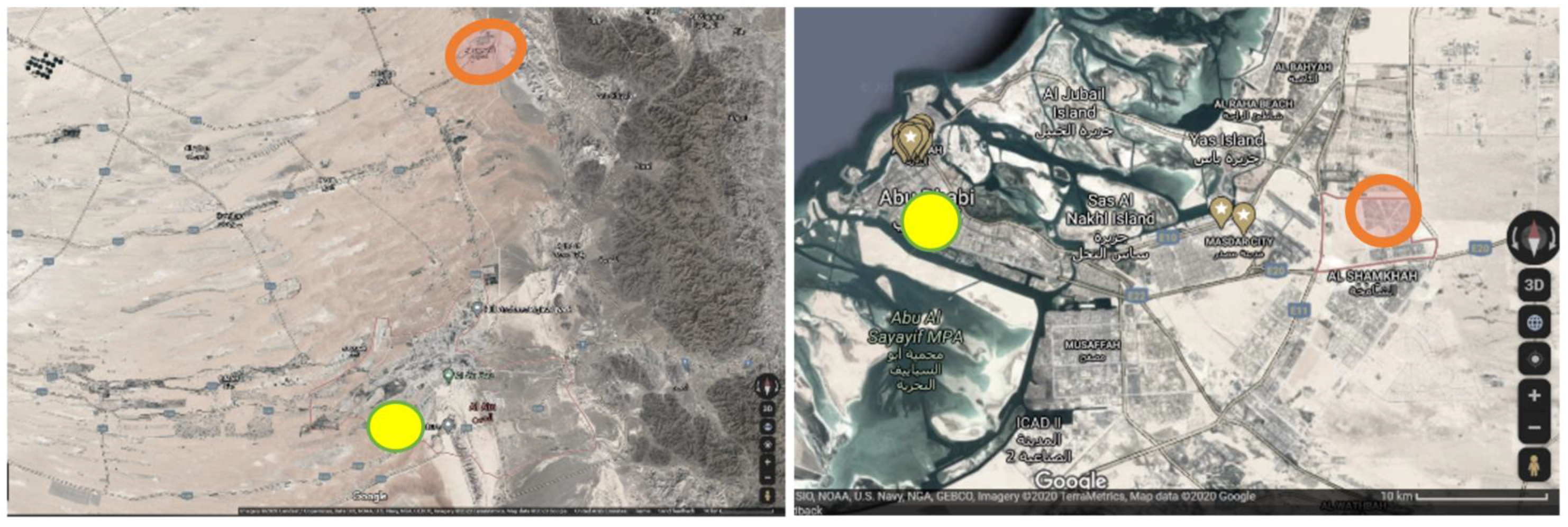
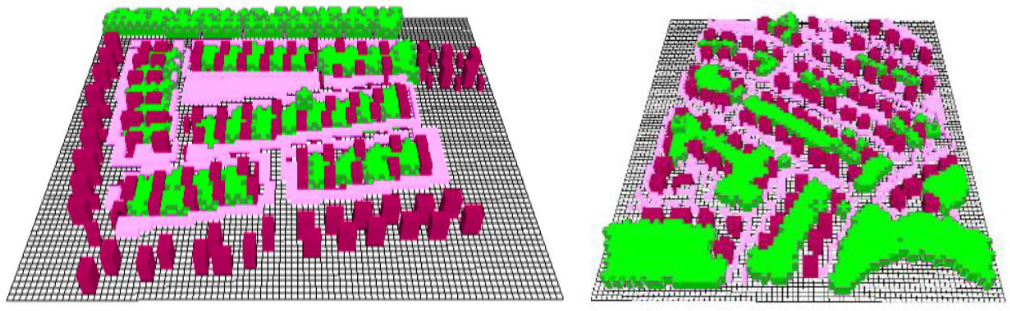
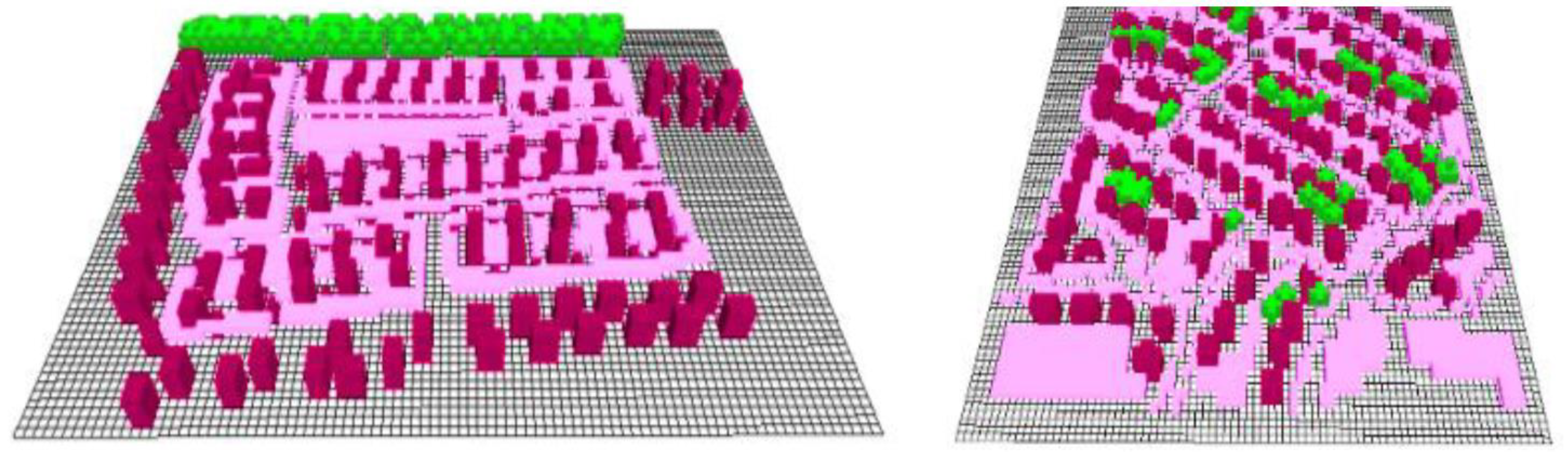
2.1. District Selection/Scenarios Evaluation
2.2. Weather Conditions
2.3. Site Measurements
2.4. Modeling and Simulations
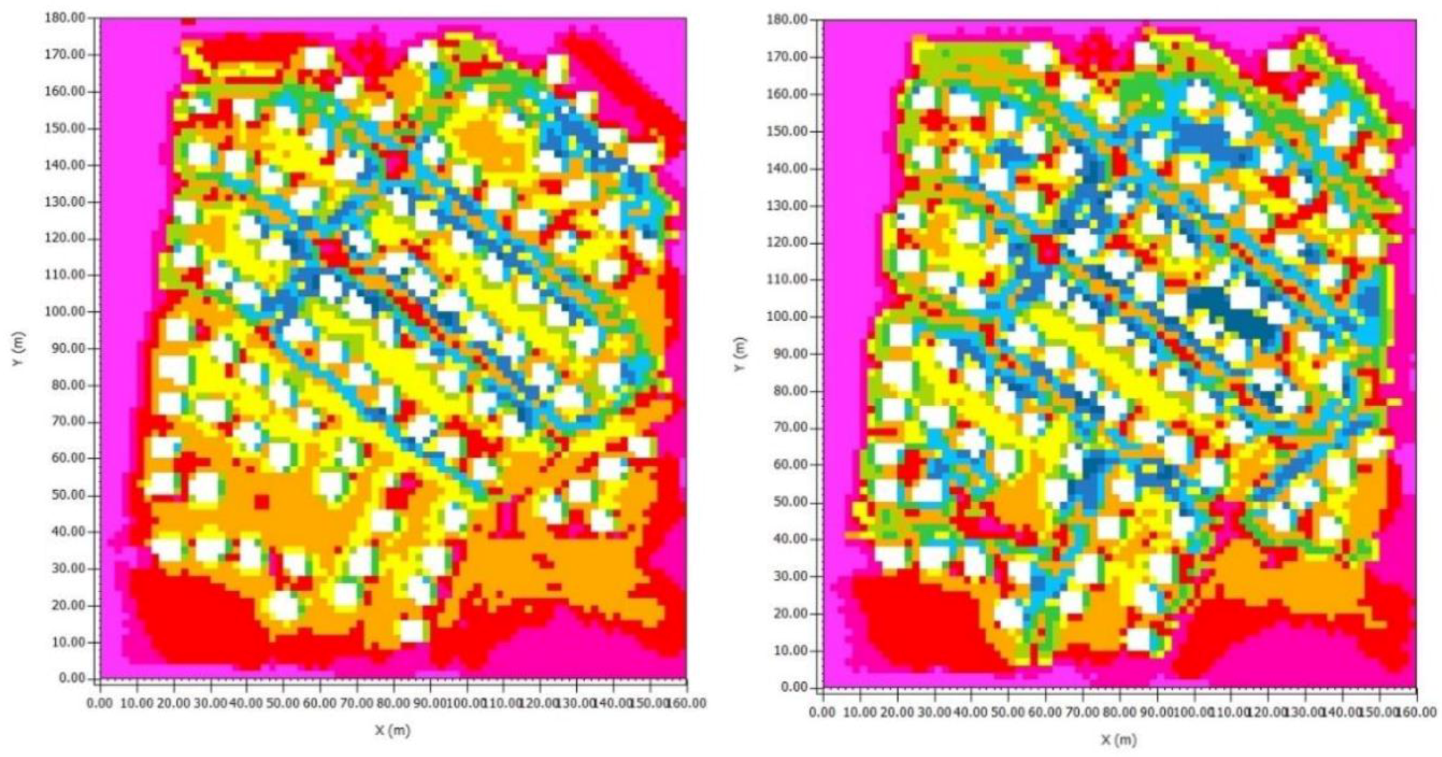
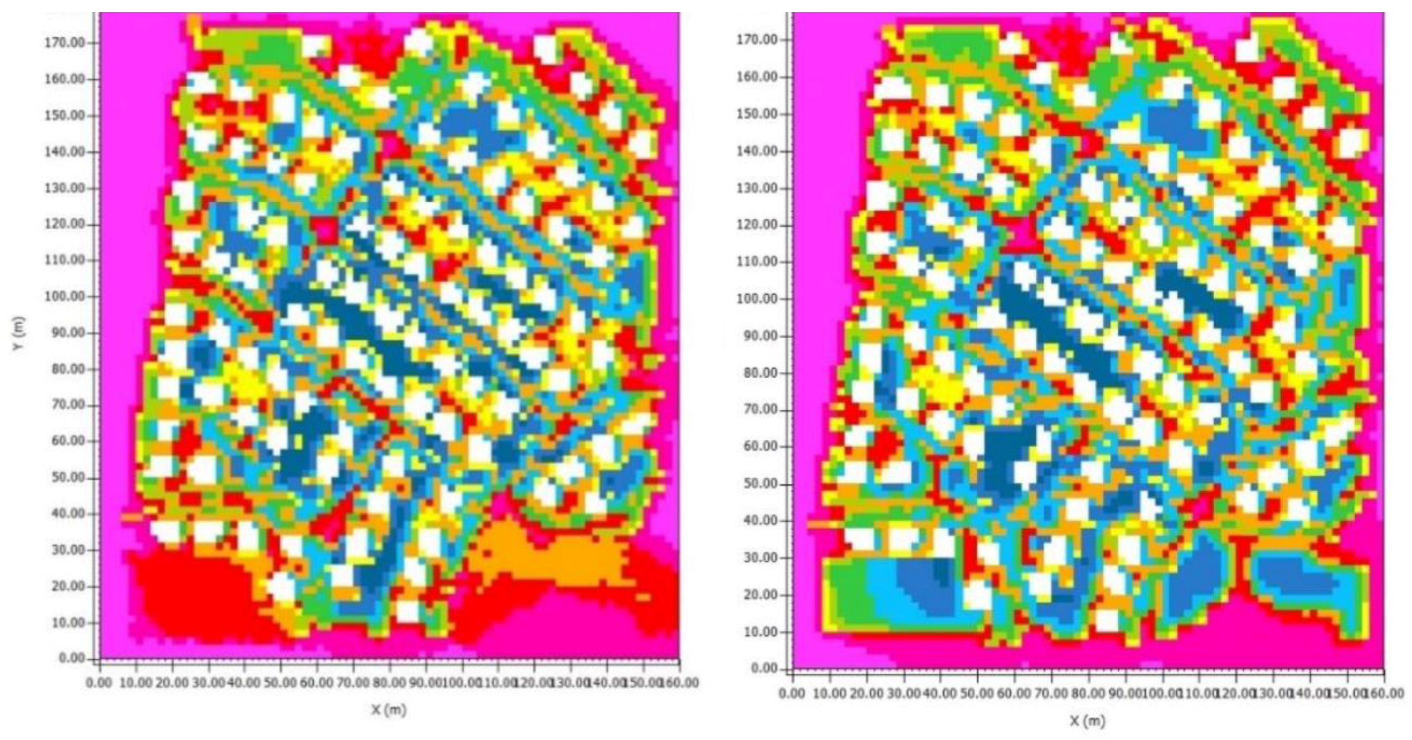
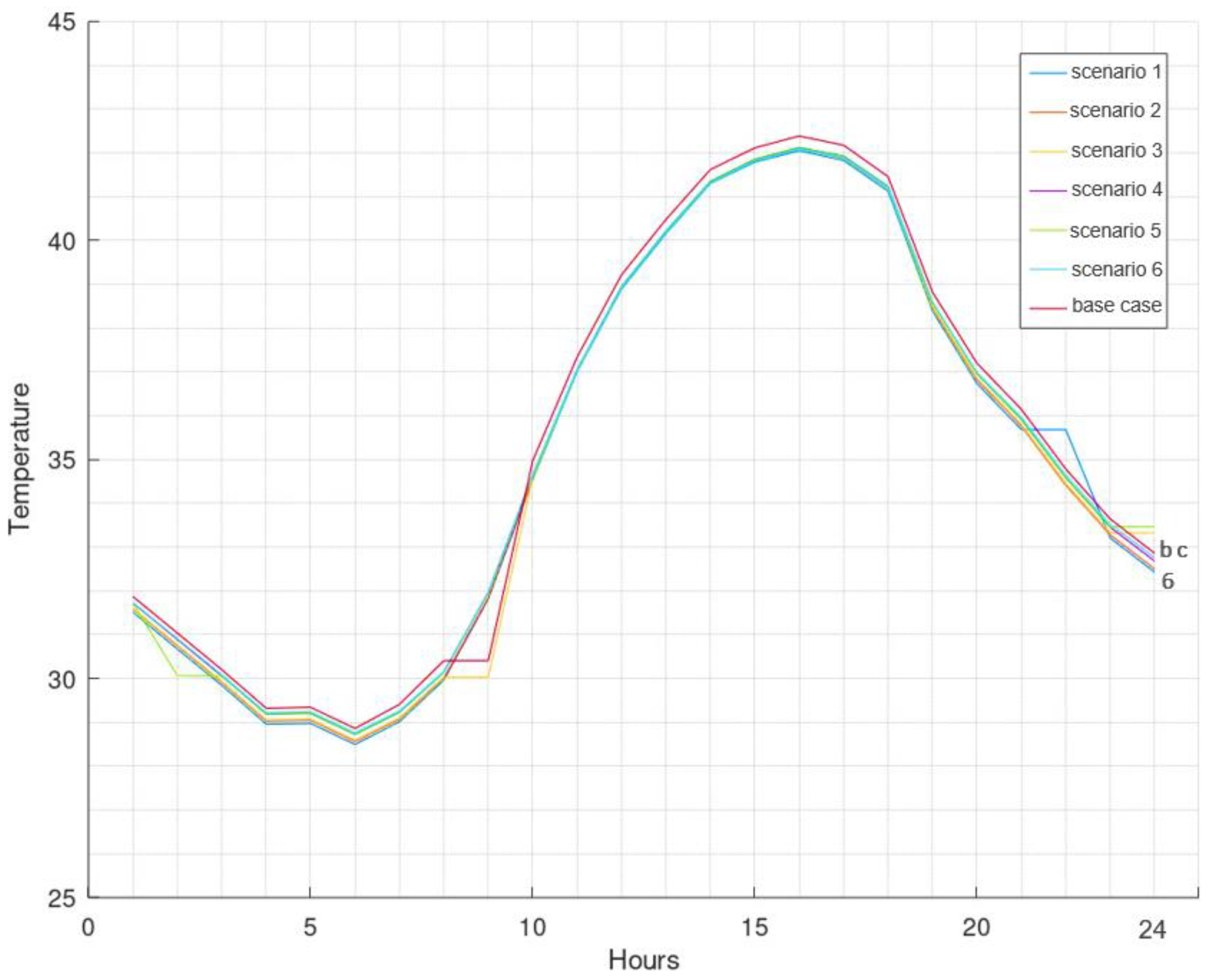
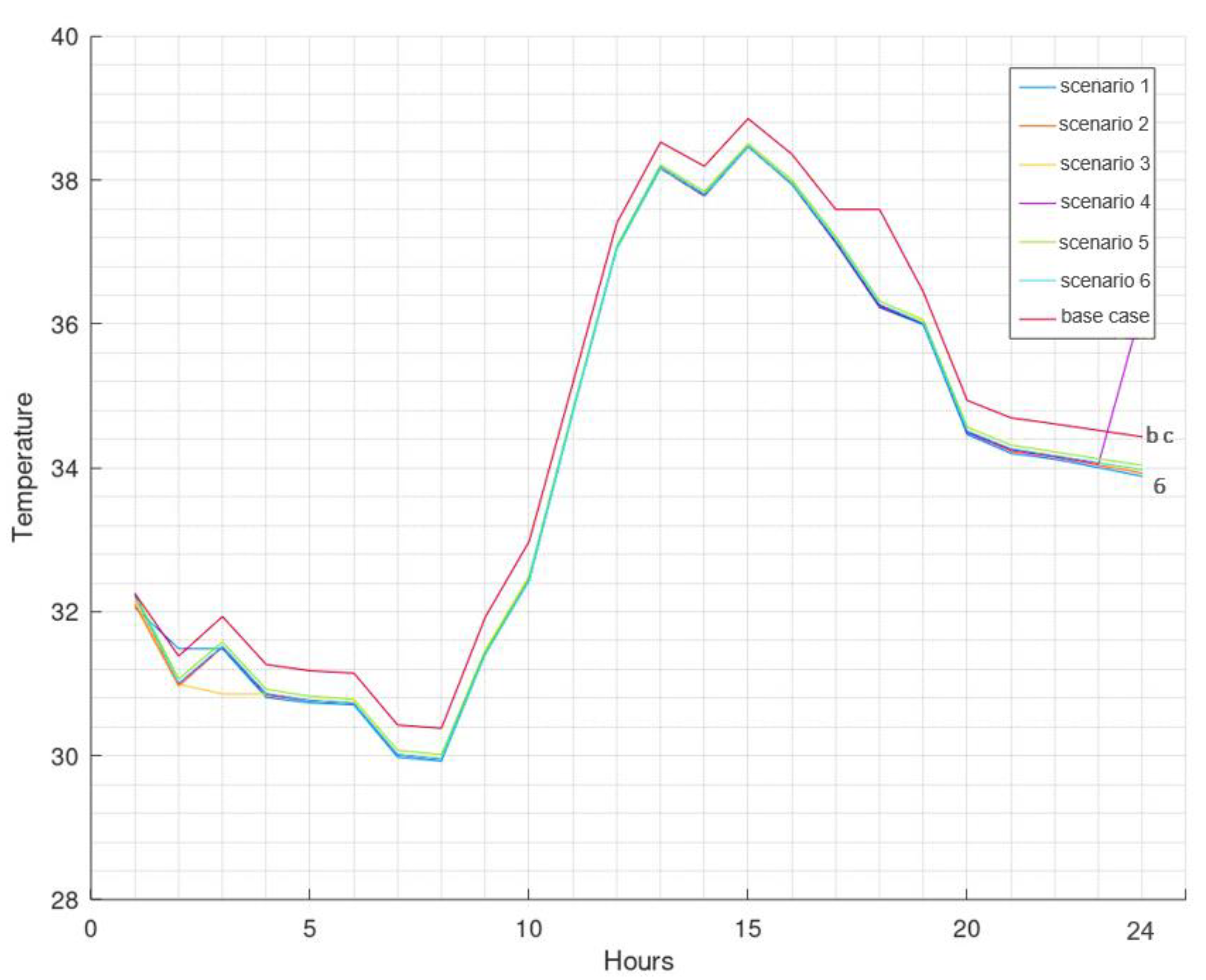
3. Results
4. Discussion
5. Conclusions
Author Contributions
Funding
Acknowledgments
Conflicts of Interest
Appendix A


References
- Krarti, M.; Dubey, K. Review analysis of economic and environmental benefits of improving energy efficiency for UAE building stock. Renew. Sustain. Energy Rev. 2018, 82, 14–24. [Google Scholar] [CrossRef]
- World Bank’s database. Electric Power Consumption; World Bank: Washington, DC, USA, 2014. [Google Scholar]
- World Energy Council. Policies for the Future; 2011 Assessment of Country Energy and Climate Policies; World Energy Council: London, UK, 2011. [Google Scholar]
- Khondaker, M.A.; Hasan, A.; Rahman, M.; Malik, M.S.; Shafiullah, K.; Muhyedeen, M. Greenhouse gas emissions from energy sector in the United Arab Emirates—An overview. Renew. Sustain. Energy Rev. 2016, 59, 1317–1325. [Google Scholar] [CrossRef]
- Alfaris, M.-A.F.; Juaidi, A.F. Energy retrofit strategies for housing sector in the arid climate. Energy Build. 2016, 131, 158–171. [Google Scholar] [CrossRef]
- Statista Research Department. Consumption of Electricity in Dubai in 2019, by Sector; Statista: Hamburg, Germany, 2020. [Google Scholar]
- Agrawal, S.K.; Pallathucheril, V.; Sangapala, P. Affordable Housing for Emiratis in the United Arab Emirates: The Case Study of Ras Al Khaimah. Hous. Policy Debate 2020, 30, 1–26. [Google Scholar] [CrossRef]
- Friess, W.A.; Rakhshan, K.; Hendawi, T.A.; Tajerzadeh, S. Wall insulation measures for residential villas in Dubai: A case study in energy efficiency. Energy Build. 2012, 44, 26–32. [Google Scholar] [CrossRef]
- Clair, P.S. Low-Energy Design in the United Arab Emirates—Building Design Principles. BEDP Environ. Des. Guid. 2009, 1–10. Available online: http://www.jstor.org/stable/26151847 (accessed on 1 March 2021).
- Aboulnaga, M.M. A roof solar chimney assisted by cooling cavity for natural ventilation in buildings in hot arid climates: An energy conservation approach in Al-Ain city. Renew. Energy 1998, 14, 357–363. [Google Scholar] [CrossRef]
- Taleb, H.M. Using passive cooling strategies to improve thermal performance and reduce energy consumption of residential buildings in U. A. E. buildings. Front. Archit. Res. 2014, 3, 154–165. [Google Scholar] [CrossRef] [Green Version]
- Lin, Y.C.; Tsai, P.T.; Liao, T.K.; Huang, C.C. Effects of thermal comfort and adaptation on park attendance regarding different shading levels and activity types. Build. Environ. 2013, 59, 599–611. [Google Scholar] [CrossRef]
- Gaitani, M.S.N.; Mihalakakou, G. On the use of bioclimatic architecture principles in order to improve thermal comfort condition in outdoor spaces. Build. Environ. 2005, 42, 317–324. [Google Scholar] [CrossRef]
- Taleb, H. Urbanizing the deserts of Dubai: An outdoor thermal comfort case study of Dubai International Academic City, UAE. In Sustainable City VII; WIT Press: Southampton, UK, 2012; Volume 1, pp. 85–95. [Google Scholar]
- Mohamed, A. The Impact of Different Urban Configurations on Outdoor Thermal Comfort: A Case Study of the Military Camps in Abu Dhabi, UAE; The British University in Dubai (BUiD): Dubai, United Arab Emirates, 2016. [Google Scholar]
- Hamdan, D.M.A.; de Oliveira, F.L. The impact of urban design elements on microclimate in hot arid climatic conditions: Al Ain City, UAE. Energy Build. 2019, 200, 86–103. [Google Scholar] [CrossRef]
- Baca, E.E.S.; Tsai, I.T. A Model-Based Approach to Measuring the Effect of Shading on Outdoor Thermal Comfort. Int. J. Eng. Technol. 2015, 7, 116–121. [Google Scholar] [CrossRef] [Green Version]
- Dhariwal, J.; Manandhar, P.; Bande, L.; Marpu, P.; Armstrong, P.; Reinhart, C.F. Evaluating the effectiveness of outdoor evaporative cooling in a hot, arid climate. Build. Environ. 2019, 150, 281–288. [Google Scholar] [CrossRef]
- Nikolopoulou, K.S.M. Thermal comfort and psychological adaptation as a guide for designing urban spaces. Energy Build. 2003, 35, 95–101. [Google Scholar] [CrossRef]
- Liu, W.; Zhang, Y.; Deng, Q. The effects of urban microclimate on outdoor thermal sensation and neutral temperature in hot-summer and cold-winter climate. Energy Build. 2016, 128, 190–197. [Google Scholar] [CrossRef]
- Bande, L. Validation of UWG and ENVI-Met Models in an Abu Dhabi District, Based on Site Measurements. Sustainability 2019, 11, 4378. [Google Scholar] [CrossRef] [Green Version]
- Reiche, D. Renewable Energy Policies in the Gulf countries: A case study of the carbon-neutral “Masdar City” in Abu Dhabi. Energy Policy 2010, 38, 378–382. [Google Scholar] [CrossRef] [Green Version]
- Shawesh, R.; Mohamed, M. Post-occupancy evaluation of outdoor thermal comfort in hot arid zone. Int. J. Low-Carbon Technol. 2020, 2020, ctaa035. [Google Scholar] [CrossRef]
- Hegazy, I.R.; Qurnfulah, E.M. Thermal comfort of urban spaces using simulation tools exploring street orientation influence of on the outdoor thermal comfort: A case study of Jeddah, Saudi Arabia. Int. J. Low-Carbon Technol. 2020, 15, 594–606. [Google Scholar] [CrossRef]
- Fanger, P.O. Thermal comfort. Analysis and applications in environmental engineering. Therm. Comf. Anal. Appl. Environ. Eng. 1970, 1, 138. [Google Scholar]
- Plan Abu Dhabi 2030—The Official Portal of the UAE Government. Available online: https://u.ae/en/about-the-uae/strategies-initiatives-and-awards/local-governments-strategies-and-plans/plan-abu-dhabi-2030 (accessed on 21 December 2020).
- ENVI-Met—Decode Urban Nature with ENVI-Met Software. Available online: https://www.envi-met.com/ (accessed on 22 February 2021).
- MATLAB. MathWorks—MATLAB & Simulink. Available online: https://www.mathworks.com/products/matlab.html (accessed on 22 February 2021).
- Bande, L. Heat Island Mitigation Strategies, with Focus on the Urban Shading Devices. The Case Study of Abu Dhabi Main Island, United Arab Emirates. Ph.D. Thesis, Masdar Institute of Science and Technology, Masdar City, United Arab Emirates, 9 March 2017. [Google Scholar]
- AbuDhabi Public Parks. Available online: https://www.dmt.gov.ae/en/adm/Parks (accessed on 22 February 2021).
- Data Sources—Climate-Data.org. Available online: https://en.climate-data.org/info/sources/ (accessed on 21 February 2021).


| PMV | Thermal Perception | Grade of Physiological Stress |
|---|---|---|
| >3 | Broiling hot | Extreme heat stress |
| 3 | Hot | Strong heat stress |
| 2 | Warm | Moderate heat stress |
| 1 | Slightly warm | Slight heat stress |
| 0 | Comfortable | No thermal stress |
| −1 | Slightly cool | Slight cold stress |
| −2 | Cool | Moderate cold stress |
| −3 | Cold | Strong cold stress |
| ≤3 | Very cold | Extreme cold stress |
| Scenarios Distribution for Al Ain District. | ||||
|---|---|---|---|---|
| Green (m2) | Shaded (m2) | Green (%) | Shaded (%) | |
| Scenario 01 | 94,294 | 0 | 100 | 0 |
| Scenario 02 | 75,873 | 18,421 | 80 | 20 |
| Scenario 03 | 56,577 | 37,717 | 60 | 40 |
| Scenario 04 | 36,089 | 58,205 | 38 | 62 |
| Scenario 05 | 17,111 | 77,183 | 18 | 82 |
| Scenario 06 | 0 | 94294 | 0 | 100 |
Publisher’s Note: MDPI stays neutral with regard to jurisdictional claims in published maps and institutional affiliations. |
© 2021 by the authors. Licensee MDPI, Basel, Switzerland. This article is an open access article distributed under the terms and conditions of the Creative Commons Attribution (CC BY) license (http://creativecommons.org/licenses/by/4.0/).
Share and Cite
Bande, L.; Adan, R.; Young, K.; Ghazal, R.; Jha, M.; Aldarmaki, A.; Aldhaheri, A.; Alneyadi, A.; Aldhaheri, S.; Khalifa, M. Outdoor Thermal Comfort Study on a District Level as Part of the Housing Programs in Abu Dhabi and Al Ain, United Arab Emirates. Land 2021, 10, 264. https://doi.org/10.3390/land10030264
Bande L, Adan R, Young K, Ghazal R, Jha M, Aldarmaki A, Aldhaheri A, Alneyadi A, Aldhaheri S, Khalifa M. Outdoor Thermal Comfort Study on a District Level as Part of the Housing Programs in Abu Dhabi and Al Ain, United Arab Emirates. Land. 2021; 10(3):264. https://doi.org/10.3390/land10030264
Chicago/Turabian StyleBande, Lindita, Rahma Adan, Kim Young, Raghad Ghazal, Mukesh Jha, Amna Aldarmaki, Atmah Aldhaheri, Asma Alneyadi, Sharina Aldhaheri, and Mira Khalifa. 2021. "Outdoor Thermal Comfort Study on a District Level as Part of the Housing Programs in Abu Dhabi and Al Ain, United Arab Emirates" Land 10, no. 3: 264. https://doi.org/10.3390/land10030264