3.1. Tracking Jianghuai Cyclones
Jianghuai cyclones from 1979 to 2010 (32 years) are tracked using the detection and tracking algorithm described in
Section 2. To make sure the statistics of Jianghuai cyclones obtained from the tracking algorithm are reliable, cyclone numbers and genesis times are compared with observation data. The Weather Bureau of Jiangsu Province has reported records of Jianghuai cyclones from 1961 to 1980 [
20]. Unfortunately, this data only contains the numbers and genesis times of Jianghuai cyclones each year and not the entire track information. The comparison investigates numbers and genesis times in 1979 and 1980, the results are shown in
Table 1. In 1979, there were 17 Jianghuai cyclones in the observation records. Seventeen Jianghuai cyclones are also tracked in the ERA-Interim reanalysis data by the tracking algorithm in 1979. The genesis times of 13 cyclones (76.5%) agree well with the observation records. In 1980, 15 Jianghuai cyclones were tracked in the reanalysis and as well as in the observation records and 9 of them (60%) coincide with genesis times. We can see that the numbers of Jianghuai cyclones detected by the tracking algorithm have good consistency with the observation records, although the genesis times have some differences. More important is that the climatological statistics obtained by the tracking algorithm is in accordance with the observation records. It is noted that historical records depend on judgments of weather charts by forecasters. It might be subjective and may lead to uncertainty. It is strongly argued that statistics of Jianghuai cyclones obtained by an objective detection and tracking algorithm can keep good homogeneity over time, which is more favorable for statistics of climatology analysis.
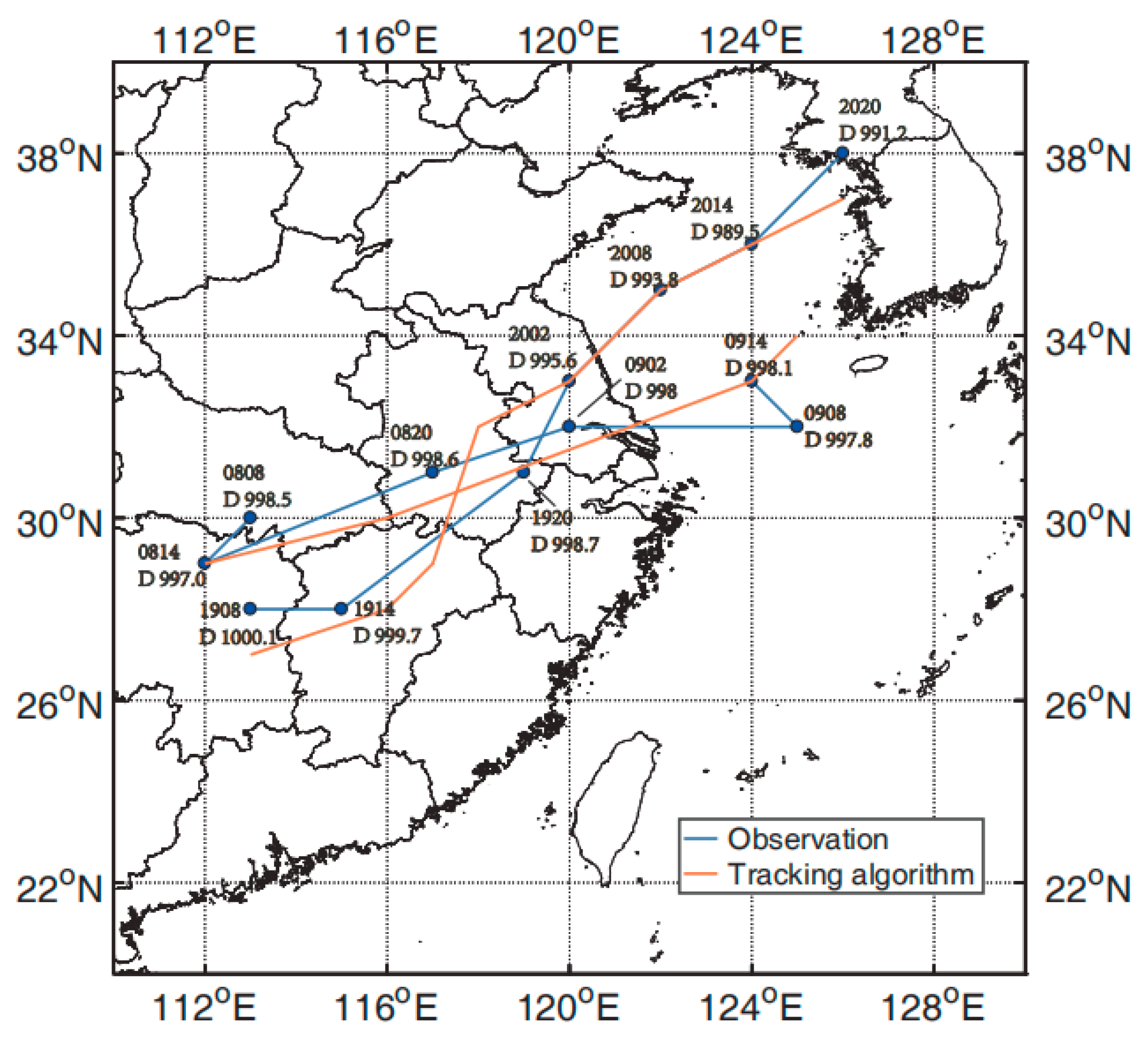
In
Figure 2, the tracks of two Jianghuai cyclones in ERA-Interim derived by the tracking algorithm (orange lines) are compared with the observations (blue lines). The two cases are from Sun et al. [
23]. One cyclone generated in 8 April 2008 and moved eastward, and the other started in 19 April 2009 and took a northeastward moving path (
Figure 2: blue lines). Upper numbers of
Figure 2 are observed occurrence times of cyclones, for example, 0820 means 20:00 China Standard Time (CST, the same below) on 8 April [
23]. Lower numbers of
Figure 2 are measured minima cyclone pressures (unit: hPa).
The first case is the Jianghuai cyclone associated with a stationary front [
23]. It generated on 8 April 2008. The moving path is west-east way. After 02:00 9 April, it moved over the sea and regenerated with stronger intensity. The tracking algorithm detected the cyclone at 02:00 8 April and its decay at 08:00 9 April in the reanalysis data. Both times are one time step ahead of the observations, but the durations of the cyclone are the same. Generally speaking, the path obtained from the tracking algorithm agrees well with the observed one.
The second case was formed by an inverted trough [
23]. It started at 08:00, 19 April 2009 (
Figure 2) and centered at 113° E, 28° N. It moved northeastward and strengthened. After 02:00 on 20 April the cyclone entered the sea and its intensity became stronger over the sea. On 20 April at 20:00, the cyclone reached the Korean Peninsula and dissipated after moving northeastward. The detection and tracking method tracked this cyclone in the reanalysis data beginning at 02:00 on 19 April 2009 at 113° E, 27° N. The time of origin is a little earlier and the position is slightly southward. The position of the cyclone at 20:00 on 19 April in the reanalysis data has deviations from the observation record in that the position derived from the tracking method is a little northwest. The tracking paths of both reanalysis data and observations coincide with each other well afterward and the dissipation time is exactly the same.
We can see that the paths of Jianghuai cyclones derived from ERA-Interim by the tracking algorithm are in good agreement with the observations. At the same time, numbers and times of Jianghuai cyclones obtained by the algorithm are in accordance with historical records. We therefore conclude that the statistics and tracks of Jianghuai cyclones derived with the tracking algorithm are reliable and can be used to investigate the climatic characteristics of Jianghuai cyclones.
3.2. Climatological Characteristics of Jianghuai Cyclones
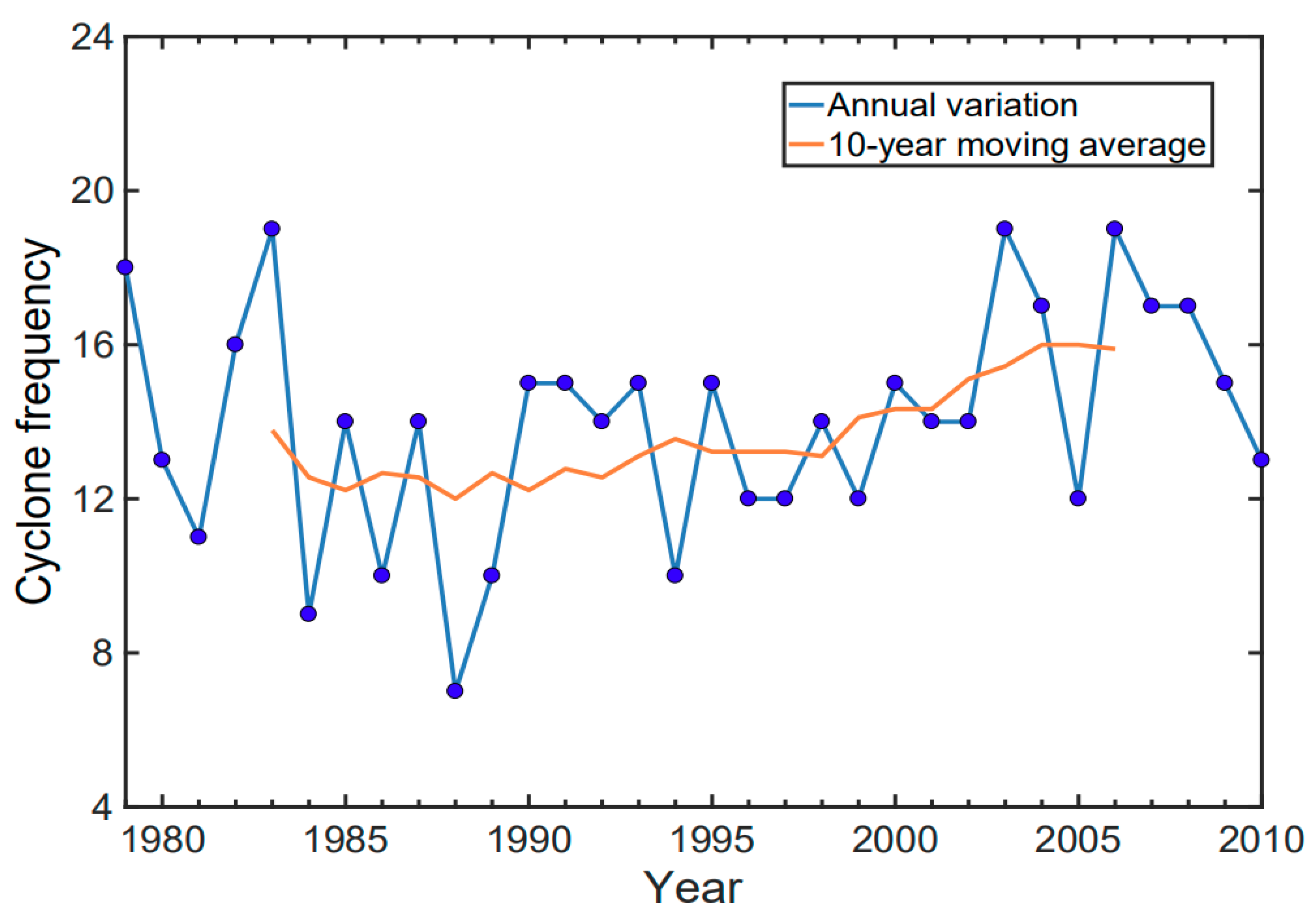
There are 452 Jianghuai cyclones in total and on average 14.125 cyclones per year in the ERA-Interim reanalysis data. This result is in agreement with the conclusions obtained by Wei et al. [
6]. The blue line of
Figure 3 shows the annual numbers of Jianghuai cyclones. Jianghuai cyclones are most frequent with a value of 19 in 1983, 2003, and 2006. The minimum number of Jianghuai cyclones occurs in 1988, only seven Jianghuai cyclones formed. Jianghuai cyclones are also much fewer in number in 1984, with nine occurrences. We can see an obvious inter-annual variability in the number of Jianghuai cyclones.
Figure 3 also shows the 10-year running average of the numbers of Jianghuai cyclones (orange line). The 10-year moving average frequency of Jianghuai cyclones shows no large differences from 1985 to 2000. However, after 2000 there is a slightly increasing trend, but this trend is not significant. This is accordance with the results of Wang et al. [
7]. Qin et al. [
24] analyzed the characteristics of cyclones entering coastal waters of China and found that the numbers of cyclones increased insignificantly from 1979 to 2012. This finding also supports our results.
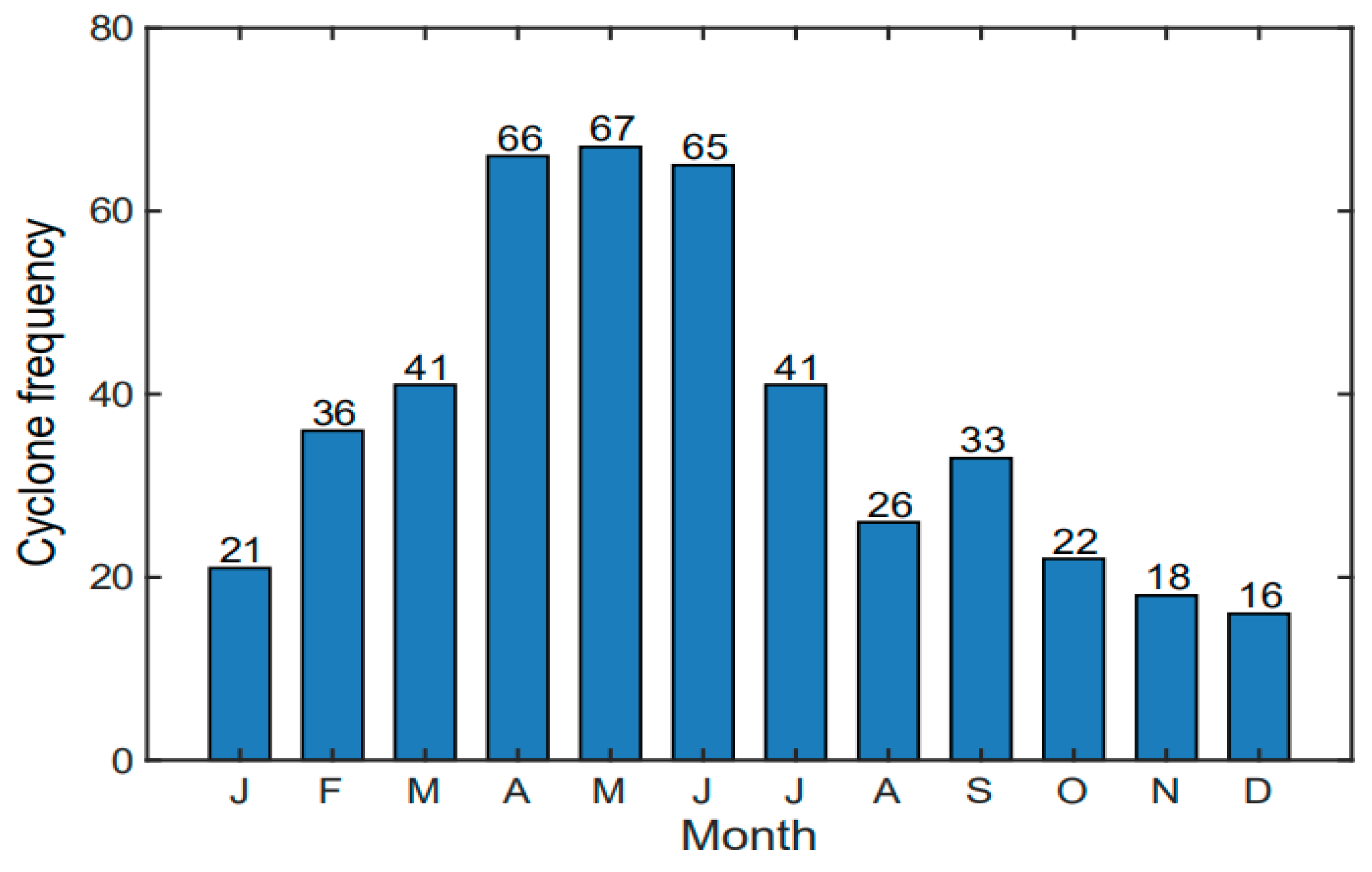
Figure 4 shows the monthly numbers of Jianghuai cyclones. It can be seen that Jianghuai cyclones occur most often in April, May, and June. The numbers of these three months account for 43.8% of the total number of Jianghuai cyclones. Jianghuai cyclones occur most often in May with 67 events (
Figure 4). The lowest number is in December (
Figure 4: 16), only accounting for 3.5% of the total number. These results agree well with the conclusions of Liu et al. [
25].
Table 2 shows the seasonal distribution of Jianghuai cyclones based on ERA-Interim reanalysis data. Jianghuai cyclones are active in spring and summer, which accounts for 38.5% and 29.2% of the total number, respectively. This is consistent with the monthly distribution of Jianghuai cyclones. In spring, the cold air is still actively encountering the moist southwesterly airflow from the northern side of the Western Pacific subtropical high. It provides the favorable baroclinic conditions for forming Jianghuai cyclones. In summer, warm temperatures and adequate moisture also support the generation and development of Jianghuai cyclones, especially in the plum rain season in Southeastern China. However, in winter, East Asia is controlled by the Mongolia and Siberia cold high, which is strong and stable. The Jianghuai cyclone activity is quite weak and is lowest in winter.
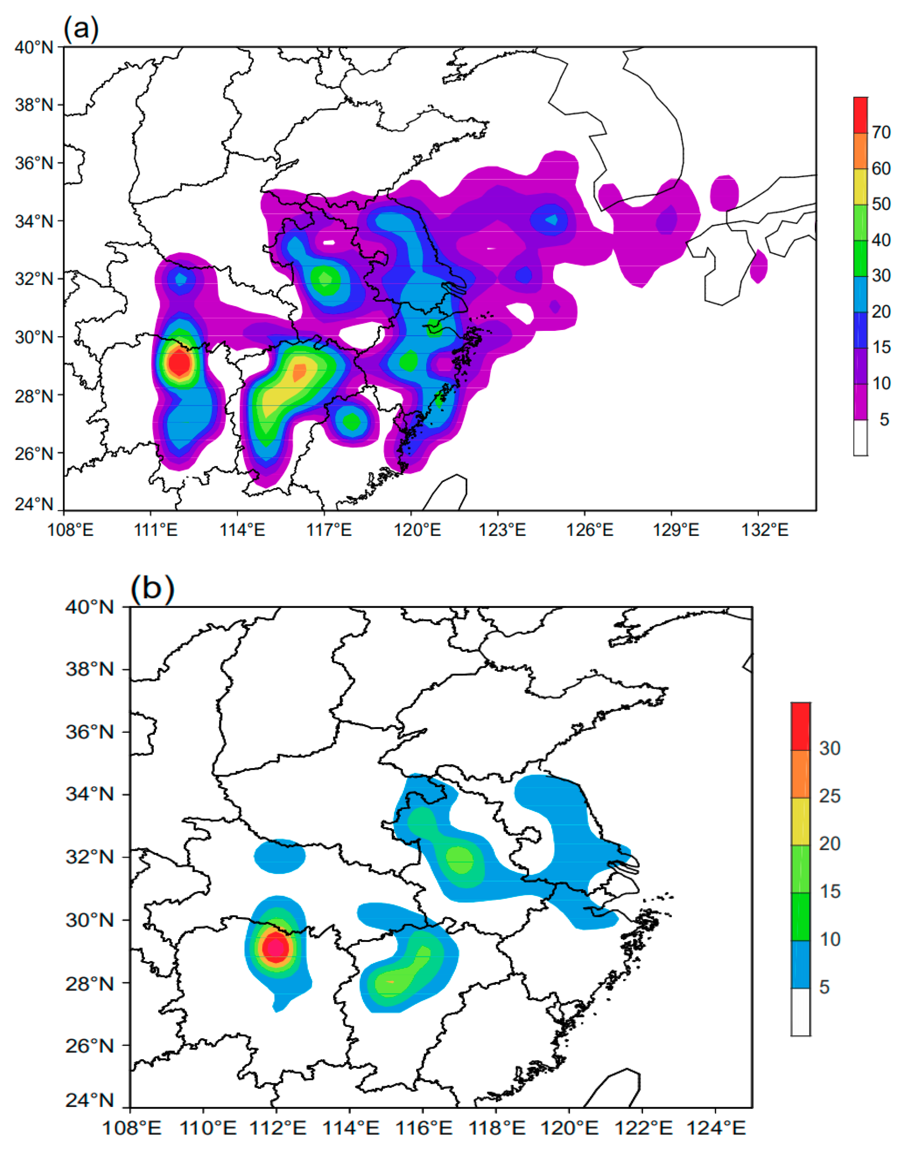
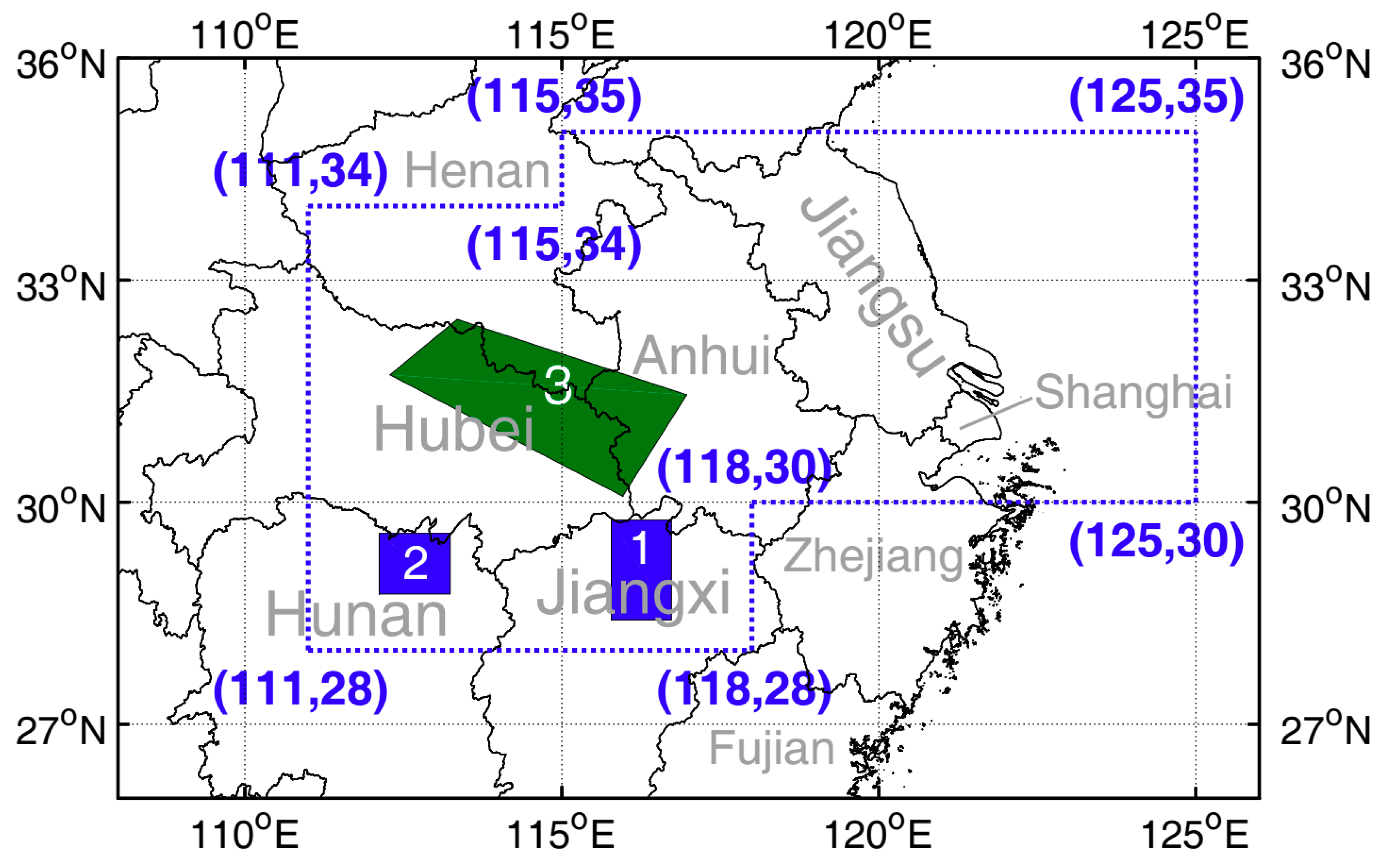
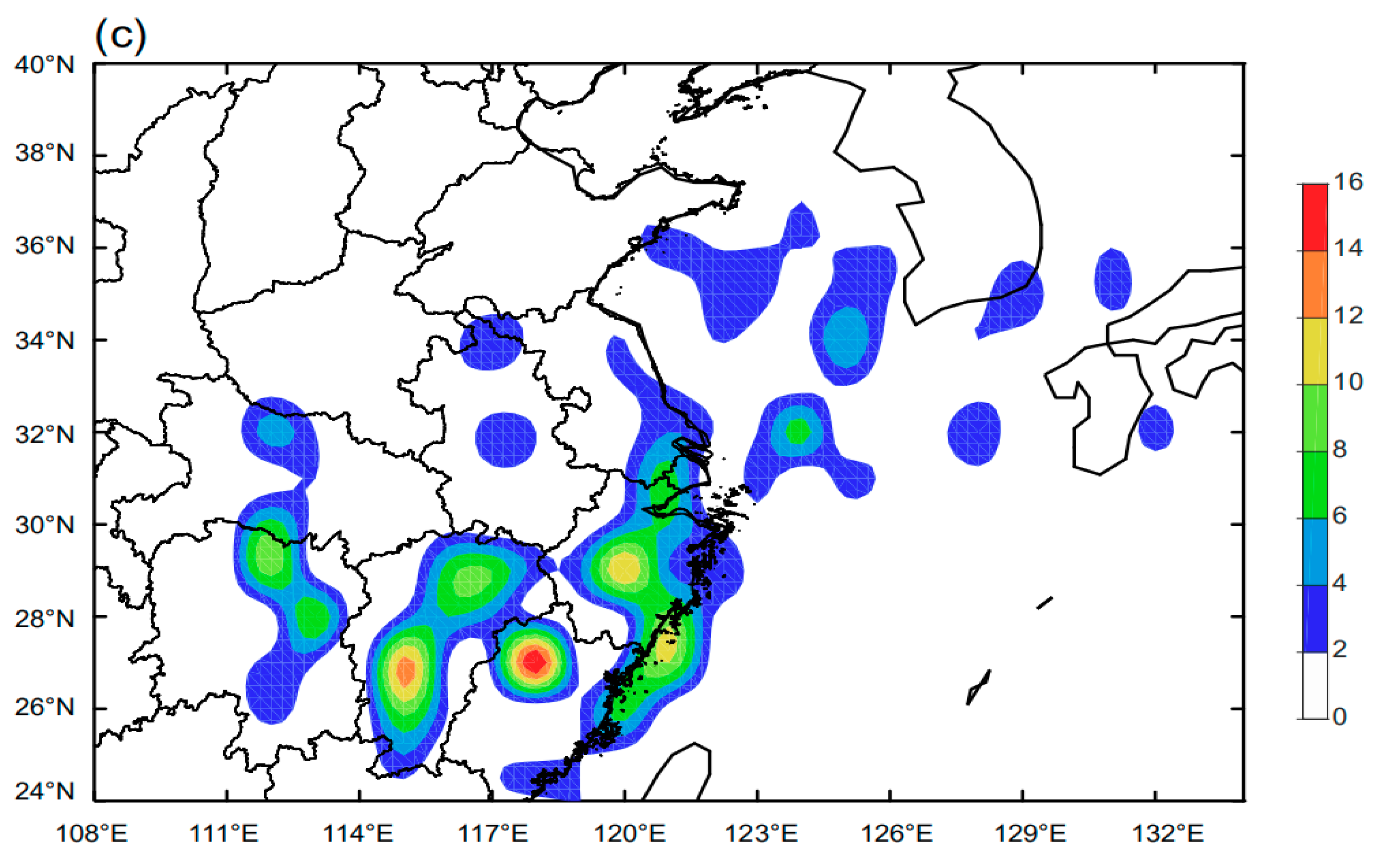
Figure 5a shows the regional density of Jianghuai cyclones. The Jianghuai cyclones mainly influence the Dongting Lake area in Hunan Province, most regions of Jiangxi Province, and the Jiangsu-Anhui plain. The areas influenced by Jianghuai cyclones include the lower reaches of the Yangtze River and the Huai River, such as Zhejiang Province and the north of Fujian Province. In
Figure 5b, we can see the origin area of Jianghuai cyclones. It has been found that the Jianghuai cyclones generate in the Dongting Lake area, Poyang Lake area, and the northeast side of Dabie Mountain area. This is in agreement with the results of Wei et al. [
6]. As the Poyang and Dongting lakes are the largest and second largest freshwater lakes in China, the warm surface temperature and abundant water vapor over the lakes provide favorable conditions for the formation and development of Jianghuai cyclones. According to the conservation of potential vorticity, it is easy to generate low-pressure systems at the lee sides of the mountains [
26], which leads to another high-frequency origin area of Jianghuai cyclones.
Figure 5c gives the distributions of lysis areas of Jianghuai cyclones. The maxima are located in the northwest of Fujian Province, that is, south of the Wuyi Mountains. Jianghuai cyclones might be prompted to decay after crossing the Wuyi Mountains, then be blocked by mountain areas in the northeast of Fujian and vanish there. Other main lysis areas can be found in the northeast of Hunan and Jiangxi, the south of Jiangxi, the middle of Zhejiang, and along the coastlines. These places are downstream regions corresponding to the genesis areas. Jianghuai cyclones can reach to the Yellow Sea of China, and as far as the Korean Peninsula and Japan.
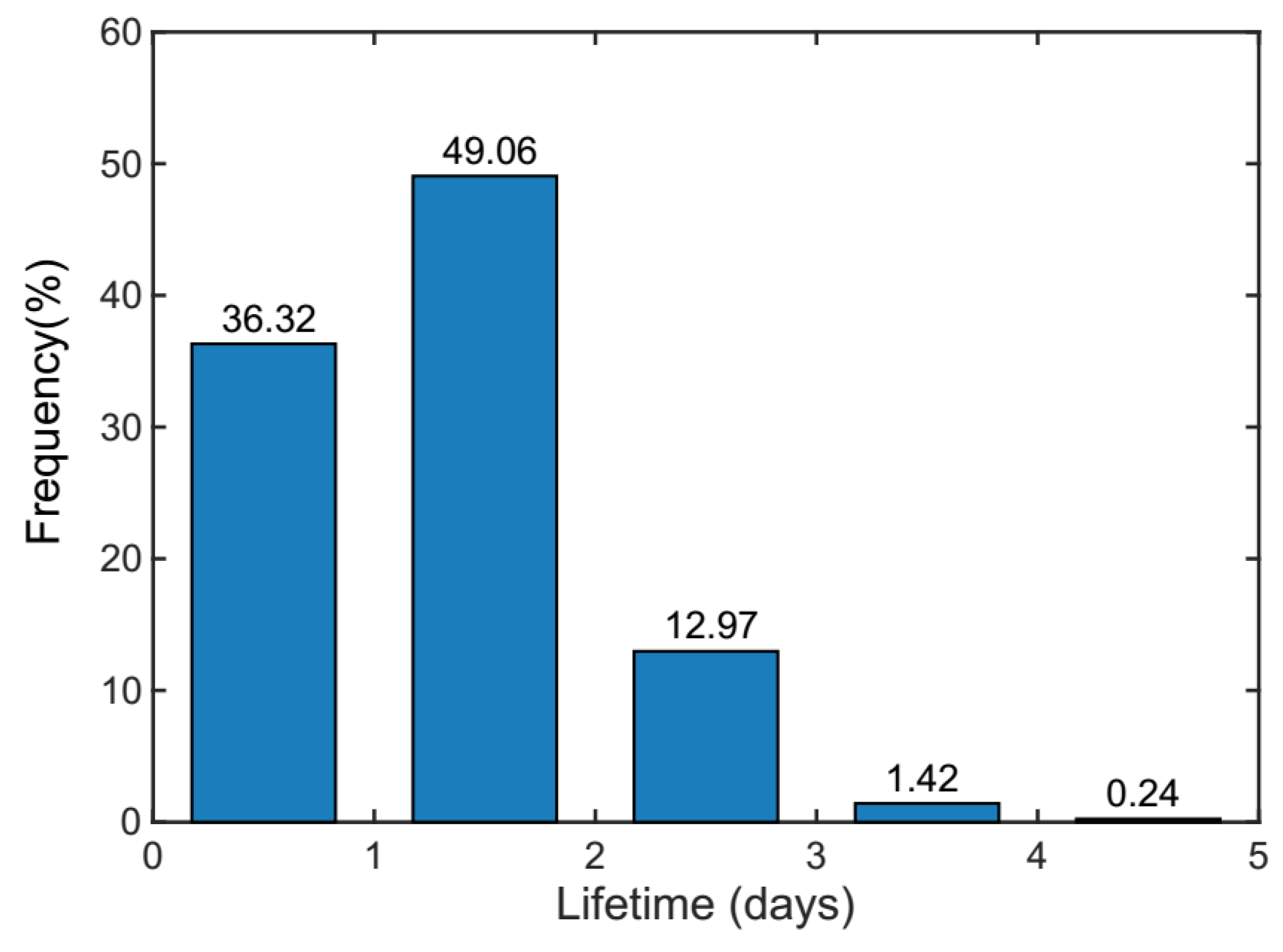
Figure 6 shows the lifetime distribution of Jianghuai cyclones. The most common lifetime of Jianghuai cyclones lasts one to two days, which accounts for 49.06% of all cyclones. The percentage of Jianghuai cyclones lasting less than one day is 36.2%. Most of the Jianghuai cyclones survive less than three days (98.34%). As Jianghuai cyclones mainly travel on the land, it might be not conducive to the cyclone surviving. On the other hand, it could be possible that at the time of the generation and dissipation, Jianghuai cyclones are too weak to be detected and tracked, which may lead to the detected short life history of Jianghuai cyclones.
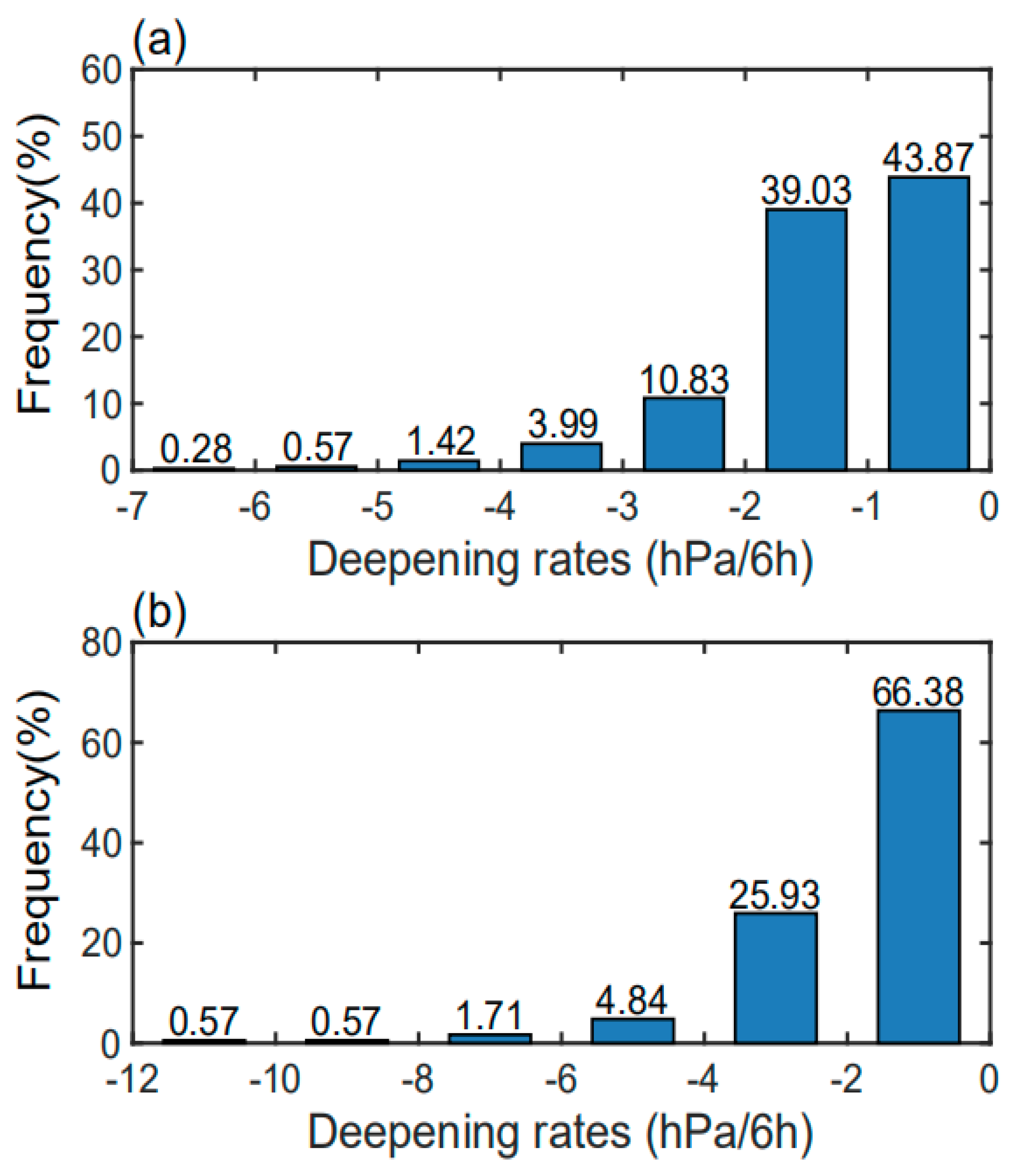
Figure 7a shows the distributions of the average deepening rates of Jianghuai cyclone pressures per 6 h. It is obvious that the decreases of central pressure of Jianghuai cyclones are mainly between 0 and 1 hPa per 6 h, accounting for 43.87% of the total dataset. A deepening rate between 1 and 2 hPa/6h is shown in 39.03% of all Jianghuai cyclones. The cyclone-average deepening pressure of Jianghuai cyclones is mostly between 0 and 4 hPa per 6 h, which occurs for 97.73% of the total number. Jianghuai cyclones that show a core pressure deepening rate of over 4 hPa per 6 h are very rare (only 2.27%). Therefore, the strength of a Jianghuai cyclone is generally not very strong.
Figure 7b shows the maximum core pressure deepening rates per 6 h of Jianghuai cyclones. If the central pressure of a cyclone decreases sharply in a short time, it will be an explosive cyclone, which is potentially dangerous with heavier rain and stronger wind speeds [
27]. We find that the maximum deepening rate of Jianghuai cyclones lies most often between 0 and 2 hPa/6h (66.38%). The second highest maximum deepening rate can be found between 2 and 4 hPa/6h with 25.93% of all cases. A maximum deepening pressure between 0 and 6 hPa/6h is found in 97.15% of all Jianghuai cyclones. There are only a few Jianghuai cyclones (2.85%) with a maximum deepening pressure larger than 6 hPa/6h. Usually marine cyclones grow explosively due to the abundant water vapor and latent heat release over the sea, which increases the baroclinicity [
28]. However, Jianghuai cyclones develop on the land most of the time, which is not conducive for explosive growth. Generally, Jianghuai cyclones are not so powerful. This could also explain why Jianghuai cyclones cannot survive very long time spans, as shown before (
Figure 6).
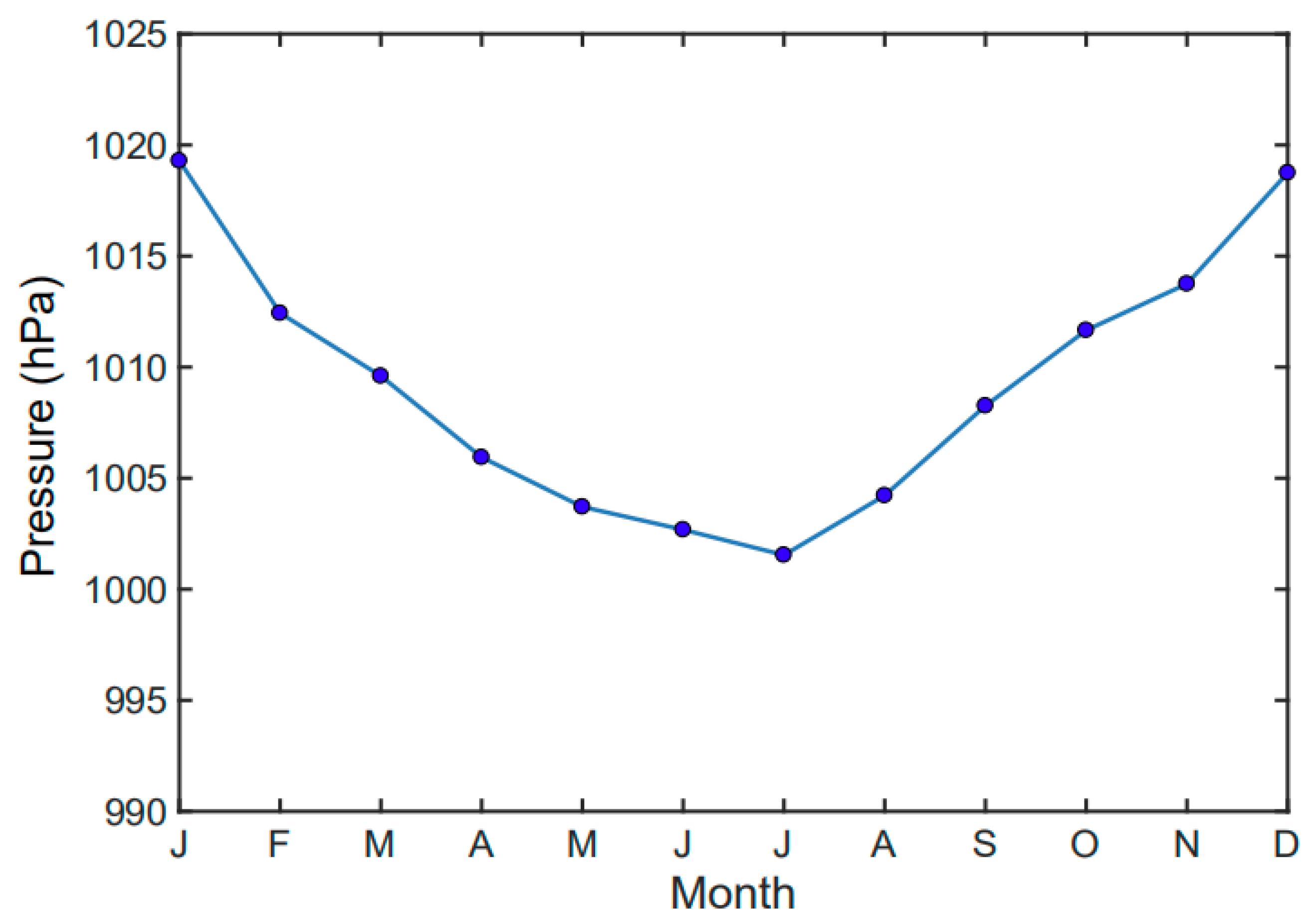
The initial pressures of Jianghuai cyclones were analyzed for different seasons (
Table 3) and months (
Figure 8). The lower the initial central pressure is, the stronger is the formation of a Jianghuai cyclone. The formation of a Jianghuai cyclone is the strongest in summer (July), while it is the weakest in winter (December), as shown in
Table 3 and
Figure 8. Again, due to the large amount of released latent heat and abundant water vapor in the plum rain season, the initial intensity of Jianghuai cyclones is relatively stronger in summer. It should be noted that spatial filtering which can remove the large-scale systems [
29,
30] is not applied before tracking in this study. Although we applied the criteria of gradients for detection, large-scale background fields can still possibly influence cyclone pressures, especially in the initial period.
3.3. Background Characteristics in the Genesis, Climax, and Lysis Periods of Jianghuai Cyclones
The mean fields at the genesis, climax, and lysis times of Jianghuai cyclones are examined to investigate the large-scale background characteristics. The genesis (lysis) time is the first (last) time in the lifespan of a Jianghuai cyclone. The climax time is chosen as the time of the lowest cyclone MSLP attained. The background fields, including vertical integral of water vapor, MSLP, horizontal divergence, geopotential height, and horizontal wind field, are studied by averaging in the genesis, climax, and lysis times of all Jianghuai cyclones.
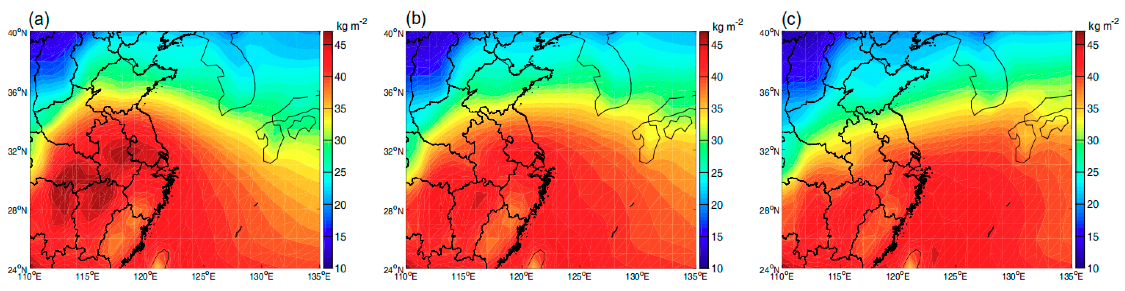
From
Figure 9a, we can find that in the genesis period, a wet tongue spreads from the mouth of the Yangtze River to the Jiangsu, Anhui, Hunan, and Jiangxi Provinces. The highest water vapor centers correspond to the lake regions, as well as the genesis areas of Jianghuai cyclones. It should be noted that the water vapor around Fujian and south of Zhejiang Provinces near the sea is relatively lower. Jianghuai cyclones can form with sufficient water vapor. However, when Jianghuai cyclones move out from the lake region, the water vapor supply reduces and might be not favorable for sustaining them until they move into the sea. This could explain why the lifetime of a Jianghuai cyclone is not very long. The wet tongue weakens and retreats to the mouth of the Yangtze River (
Figure 9b) while Jianghuai cyclones develop. Water vapor maxima over the lake regions decrease compared with the genesis time. At the lysis time (
Figure 9c), the wet tongue disappears over the land and water vapor maxima of Hunan and Jiangxi subdue so much that it is unfavorable for Jianghuai cyclones to survive.
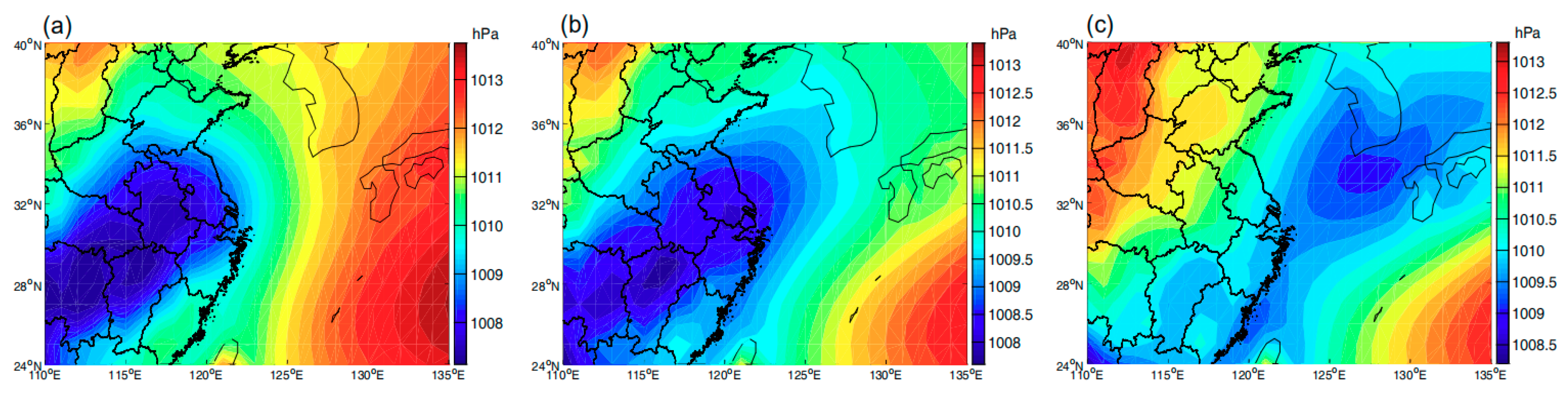
At the genesis time, MSLP is lower around the Yangtze-Huai River basin (
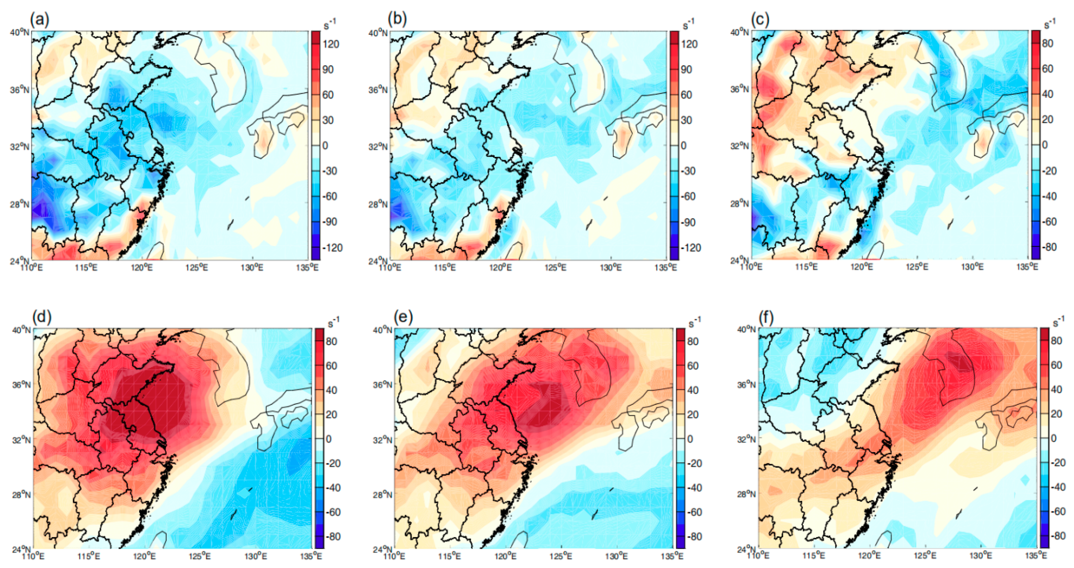
Figure 10a). At the same time, convergence can be found over this area at 850 hPa (
Figure 11a) while divergence occurs over the Yangtze-Huai River basins at 200 hPa (
Figure 11d). It indicates that the ascending flow is strong over this region. However, the center of divergence is located northeast over the Yellow Sea. Lower heights lie in the southeast of China at 850 hPa (
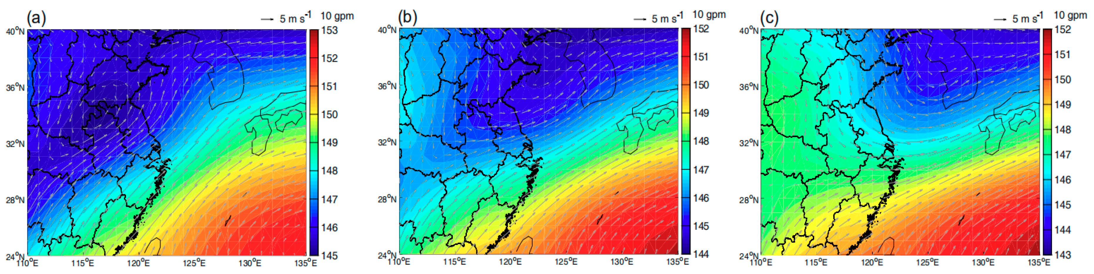
Figure 12a), which is opposite at 500 hPa and 200 hPa levels (not shown), that is, higher heights are located in these areas. The lowest geopotential height center appears around the boundary between Shandong and Anhui Province (
Figure 12a). Cyclonic winds are corresponding to this height low (
Figure 12a). The trough line of geopotential height extends southwestward. The MSLP low is situated at the front of the height trough at 850 hPa. North winds (cold air) leading around the trough at 850 hPa could meet with the southwest winds (warm and humid air) over the Yangtze-Huai River basin (
Figure 12a) which increase the baroclinicity. Higher humidity, lower MSLP, and ascending air accompanied with the intersections of north and south winds all provide favorable backgrounds for formations of Jianghuai cyclones.
At the climax time, which is defined as MSLP of a Jianghuai cyclone deepens to the minimum, the average vertical integral of water vapor already begins to reduce (
Figure 9b). MSLP lows enlarge to the Yellow Sea (
Figure 10b). However, convergence at 850 hPa decreases (
Figure 11b). The maxima of divergence at 200 hPa (
Figure 11e) and geopotential height low (
Figure 12b) both shift northeastward to the Yellow Sea and recede. The southwest winds (
Figure 12b) are not so strong as the genesis period either. We can see that although the influences of MSLP lows seem to enlarge, backgrounds like the water vapor, divergence, and geopotential height which are essential to developments of Jianghuai cyclones fall into a substantial decline.
At the lysis time, it can be found that the wet tongue over the Yangtze-Huai River basin has vanished (
Figure 9c). MSLP lows over the study area weaken obviously (
Figure 10c). Convergence at 850 hPa reduces and retreats to the south (
Figure 11c), as well as the divergence at 200 hPa (
Figure 11f). It implies that the updraft decreases. The largest divergence center at 200 hPa is located around the Korean Peninsula. As shown in
Figure 12c, the geopotential height low and trough over Anhui and Jiangsu Provinces do not exist, as opposed to the genesis time (
Figure 12a). The southwesterly winds are also weaker and only occupy the south (
Figure 12c). Therefore, water vapor conditions, MSLP low, ascending flow, and baroclinicity all decrease, which is not supportive for the further developments of Jianghuai cyclones at the decaying stage.


