Use of Citizen Science-Derived Data for Spatial and Temporal Modeling of Particulate Matter near the US/Mexico Border


Abstract
:1. Introduction
2. Materials and Methods
2.1. Model Building
2.2. Prediction
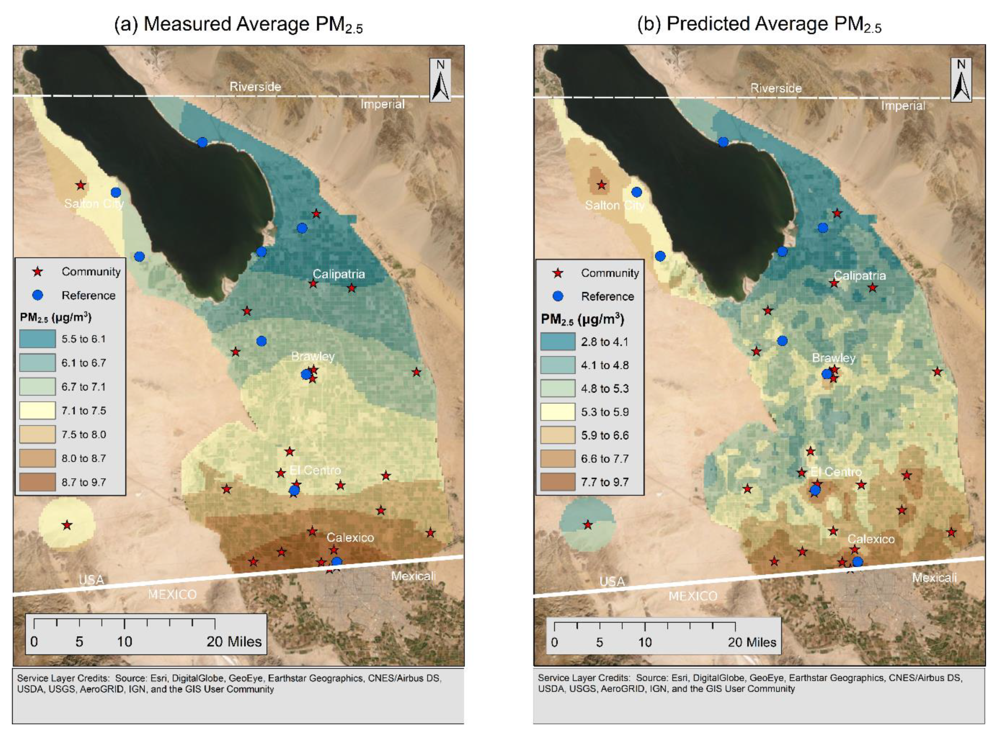
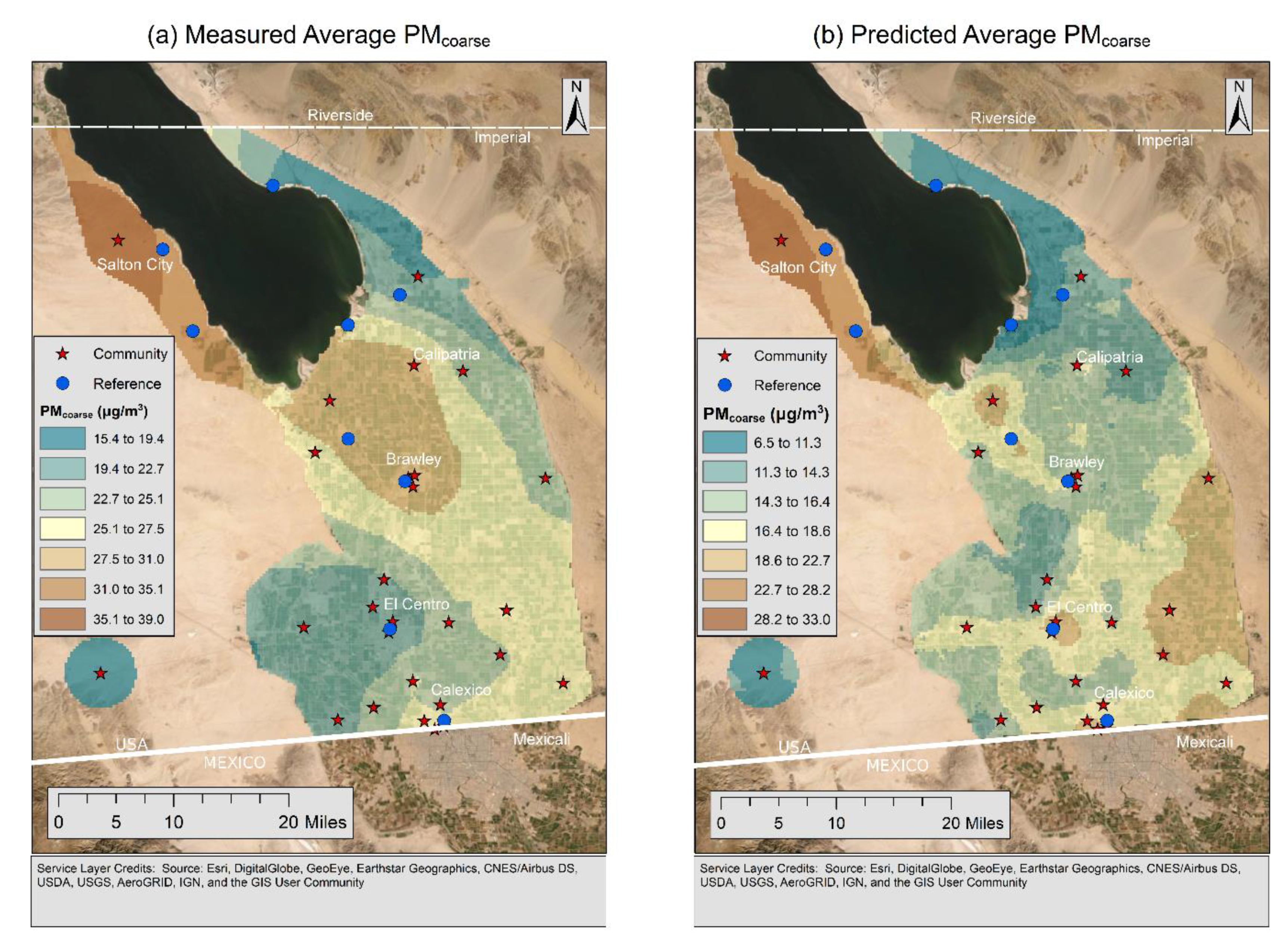
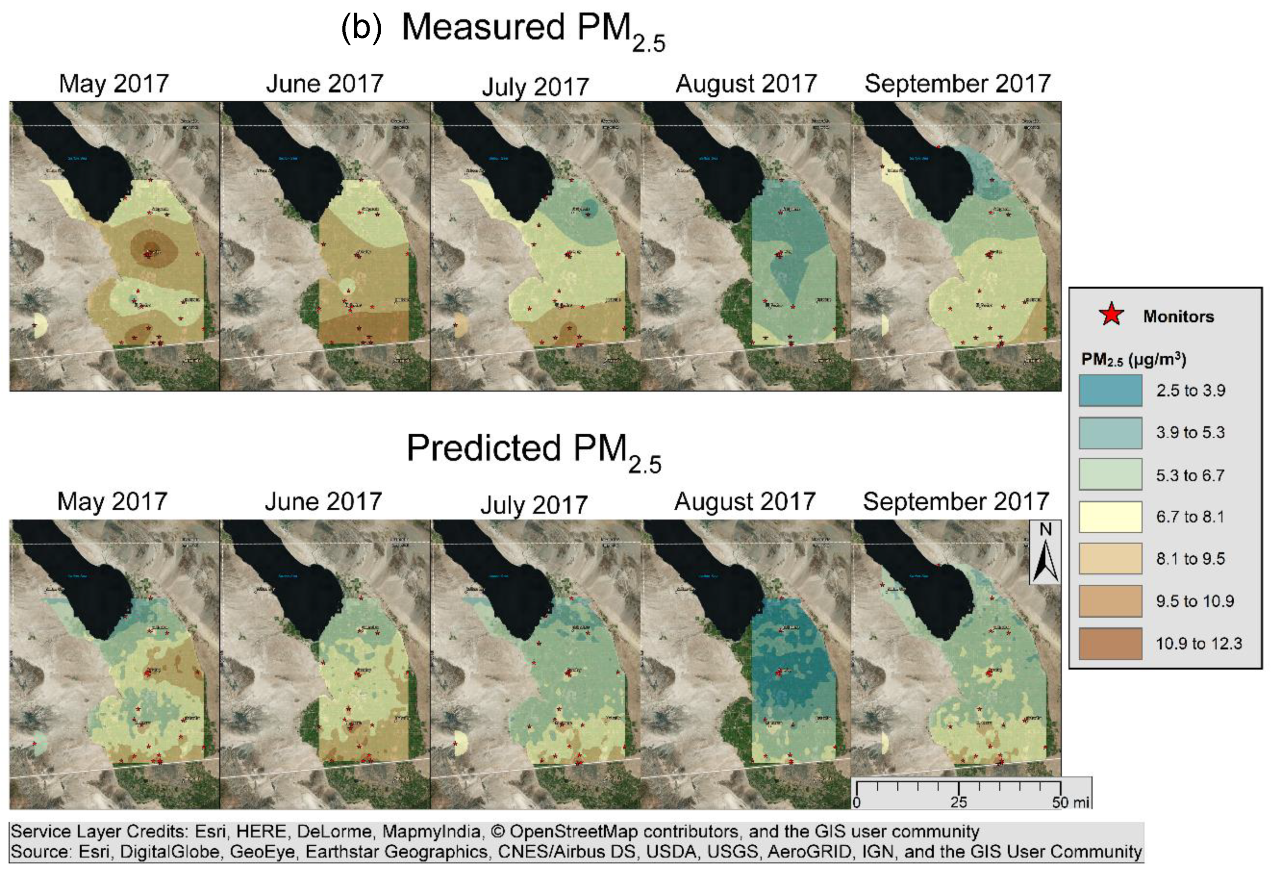
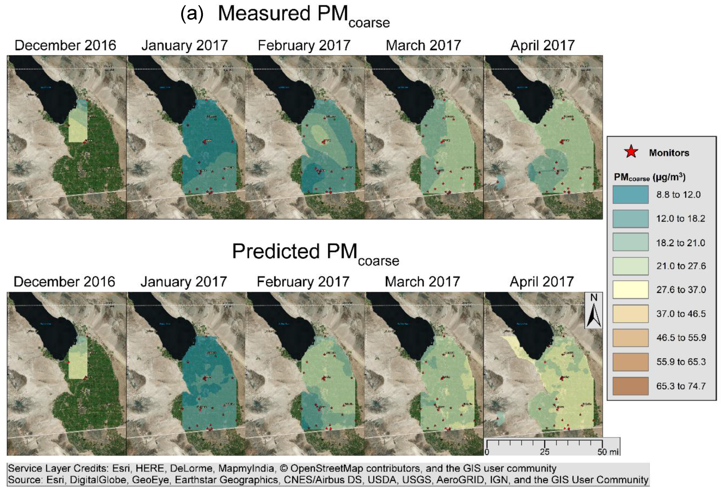
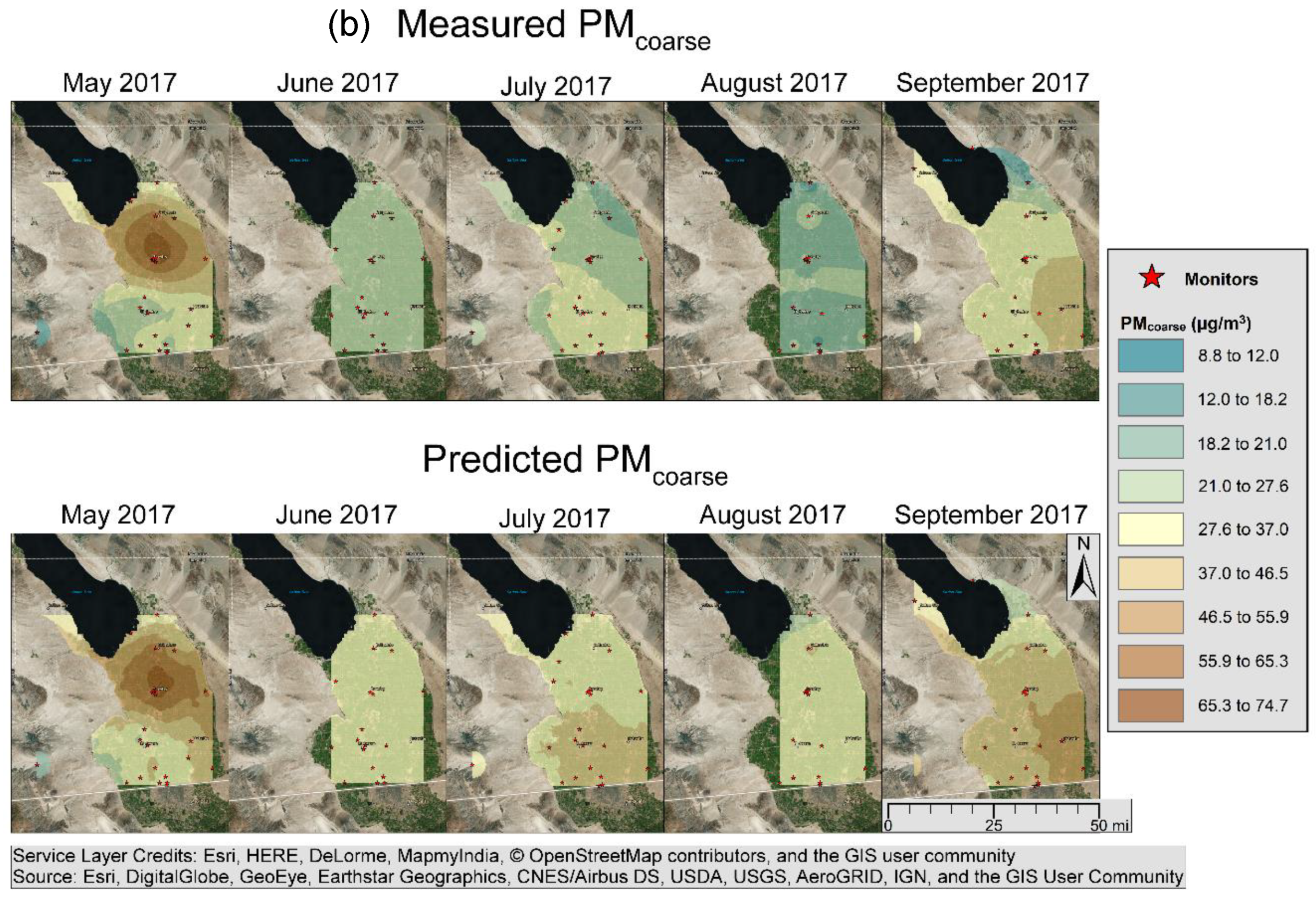
3. Results
4. Discussion
Author Contributions
Funding
Acknowledgments
Conflicts of Interest
References
- Anderson, J.O.; Thundiyil, J.G.; Stolbach, A. Clearing the air: A Review of the Effects of Particulate Matter Air Pollution on Human Health. J. Med. Toxicol. 2011, 8, 166–175. [Google Scholar] [CrossRef] [PubMed]
- Brook, R.D.; Newby, D.E.; Rajagopalan, S. The Global Threat of Outdoor Ambient Air Pollution to Cardiovascular Health: Time for Intervention. JAMA Cardiol. 2017, 2, 353–354. [Google Scholar] [CrossRef]
- Khreis, H.; Kelly, C.; Tate, J.; Parslow, R.; Lucas, K.; Nieuwenhuijsen, M. Exposure to Traffic-related Air Pollution and Risk of Development of Childhood Asthma: A Systematic Review and Meta-analysis. Environ. Int. 2017, 100, 1–31. [Google Scholar] [CrossRef]
- Atkinson, R.W.; Butland, B.K.; Dimitroulopoulou, C.; Heal, M.R.; Stedman, J.R.; Carslaw, N.; Jarvis, D.; Heaviside, C.; Vardoulakis, S.; Walton, H.; et al. Long-term Exposure to Ambient Ozone and Mortality: A Quantitative Systematic Review and Meta-analysis of Evidence from Cohort Studies. BMJ Open. 2016, 6. [Google Scholar] [CrossRef] [PubMed]
- U.S. EPA. What Is PM? Available online: https://www3.epa.gov/region1/airquality/pm-what-is.html (accessed on 20 August 2019).
- Eeftens, M.; Beelen, R.; Hoogh, K.D.; Bellander, T.; Cesaroni, G.; Cirach, M.; Declercq, C.; Dėdelė, A.; Dons, E.; de Nazelle, A.; et al. Development of Land Use Regression Models for PM2.5, PM2.5 Absorbance, PM10 and PMcoarse in 20 European Study Areas; Results of the ESCAPE Project. Environ. Sci. Technol. 2012, 46, 11195–11205. [Google Scholar] [CrossRef] [PubMed]
- Hoek, G.; Beelen, R.; Hoogh, K.D.; Vienneau, D.; Gulliver, J.; Fischer, P.; Briggs, D.J. A Review of Land-use Regression Models to Assess Spatial Variation of Outdoor Air Pollution. Atmos. Environ. 2008, 42, 7561–7578. [Google Scholar] [CrossRef]
- U.S. Census Bureau. State and County QuickFacts, Imperial County, California; Government Printing Office: Washington, DC, USA; U.S. Census Bureau: Washington, DC, USA, 2010. Available online: http://quickfacts.census.gov/qfd/states/06/06025.html (accessed on 22 August 2019).
- California Department of Public Health. Asthma ED Visits, Children. 2014. Available online: http://www.californiabreathing.org/asthma-data/county-comparisons/edvisits-children (accessed on 20 October 2017).
- Imperial County Air Pollution Control District. Imperial County 2018 Redesignation Request and Maintenance Plan for Particulate Matter Less Than 10 Microns in Diameter. Available online: https://www.arb.ca.gov/planning/sip/planarea/imperial/sip.pdf (accessed on 20 January 2019).
- Imperial County Air Pollution Control District. Imperial County 2018 Annual Particulate Matter Less Than 2.5 Microns in Diameter State Implementation Plan. Available online: https://www.co.imperial.ca.us/AirPollution/PublicNotices/PDFs/PublicHearings/20180424PM25AnnualSIP/DraftVersion/2018ICPM25SIPDRAFTv3.pdf (accessed on 20 January 2019).
- California Air Resources Board. Chronology of State PM10 Designations. Available online: http://www.arb.ca.gov/desig/changes/pm10.pdf (accessed on 20 October 2017).
- English, P.; Olmedo, L.; Bejarano, E.; Lugo, H.; Murillo, E.; Seto, E.; Wong, M.; King, G.; Wilkie, A.; Meltzer, D.; et al. The Imperial County Community Air Monitoring Network: A Model for Community-based Environmental Monitoring for Public Health Action. Environ. Health. Perspect. 2017, 125, 074501. [Google Scholar] [CrossRef] [PubMed] [Green Version]
- Imperial IVAN Air Monitoring. Available online: https://ivan-imperial.org/air (accessed on 20 August 2019).
- Carvlin, G.; Lugo, H.; Olmedo, L.; Bejarano, E.; Wilkie, A.; Meltzer, D.; Wong, M.; King, G.; Northcross, A.; Jerrett, M.; et al. Development and Field Evaluation of a Community-Engaged Particulate Matter Air Quality Monitoring Network in Imperial, California, USA. J. Air. Waste Manag. Assoc. 2017, 67, 1342–1352. [Google Scholar] [CrossRef] [PubMed]
- Winkler, P. The growth of atmospheric aerosol particles as a function of the relative humidity-II. An improved concept of mixed nuclei. J. Aerosol. Sci. 1973, 4, 373–387. [Google Scholar] [CrossRef]
- California Air Resources Board. Annual Network Plan. 2017. Available online: https://www.arb.ca.gov/aqd/amnr/amnr2017.pdf (accessed on 5 November 2017).
- Imperial County Air Pollution Control District. Quality Assurance Quality Control Plan for the Salton Sea Air Monitoring Network. Available online: http://www.water.ca.gov/saltonsea/docs/Appendix_10_FINAL_QA-QC_PLAN.pdf (accessed on 19 November 2017).
- Met One. BAM 1020 Particulate Monitor Operation Manual Rev G. pp 7 and 41. 2008. Available online: https://arb.ca.gov/airwebmanual/instrument_manuals/Documents/BAM-1020-9800%20Manual%20Rev%20G.pdf (accessed on 5 November 2017).
- ThermoFisher Scientific. TEOM 1405 Ambient Particulare Monitor Revision A. 2008. Available online: https://tools.thermofisher.com/content/sfs/manuals/EPM-TEOM1405-Manual.pdf (accessed on 5 November 2017).
- Sampson, P.D.; Richards, M.; Szpiro, A.A.; Bergen, S.; Sheppard, L.; Larson, T.V.; Kaufman, J.D. A Regionalized National Universal Kriging Model using Partial Least Squares Regression for Estimating Annual PM2.5 Concentrations in Epidemiology. Atmos. Environ. 2013, 75, 383–392. [Google Scholar] [CrossRef] [PubMed]
- Mercer, L.D.; Szpiro, A.A.; Sheppard, L.; Lindström, J.; Adar, S.D.; Allen, R.W.; Avol, E.L.; Oron, A.P.; Larson, T.F.; Liu, L.-J.S.; et al. Comparing Universal Kriging and Land-use Regression for Predicting Concentrations of Gaseous Oxides of Nitrogen (NOx) for the Multi-Ethnic Study of Atherosclerosis and Air Pollution (MESA Air). Atmos. Environ. 2011, 45, 4412–4420. [Google Scholar] [CrossRef] [PubMed]
- Knibbs, L.D.; Hewson, M.G.; Bechle, M.J.; Marshall, J.D.; Barnett, A.G. A National Satellite-based Land-use Regression Model for Air Pollution Exposure Assessment in Australia. Environ. Res. 2014, 135, 204–211. [Google Scholar] [CrossRef] [PubMed]
- Chipman, H.A.; George, E.I.; McCulloch, R.E. BART: Bayesian Additive Regression Trees. Ann. Appl. Stat. 2010, 4, 266–298. [Google Scholar] [CrossRef]
- Wu, J.; Huang, L.; Pan, X. A Novel Bayesian Additive Regression Trees Ensemble Model Based on Linear Regression and Nonlinear Regression for Torrential Rain Forecasting. In Proceedings of the Third International Joint Conference on Computational Science and Optimization (CSO), Huangshan, China, 28–31 May 2010; pp. 466–470. [Google Scholar] [CrossRef]
- Blattenberger, G.; Fowles, R. Avalanche Forecasting: Using Bayesian Additive Regression Trees (BART). In Demand for Communications Services—Insights and Perspectives. The Economics of Information, Communication, and Entertainment; Alleman, J., Ní-Shúilleabháin, Á., Rappoport, P., Eds.; Springer: Boston, MA, USA, 2014; pp. 211–227. [Google Scholar]
- Chipman, H.A.; George, E.I.; Lemp, J.; McCulloch, R.E. Bayesian Flexible Modeling of Trip Durations. Transp. Res. B Meth. 2010, 44, 686–698. [Google Scholar] [CrossRef]
- Wolf, K.; Cyrys, J.; Harciníková, T.; Gu, J.; Kusch, T.; Hampel, R.; Schneider, A.; Peters, A.M. Land Use Regression Modeling of Ultrafine Particles, Ozone, Nitrogen Oxides and Markers of Particulate Matter Pollution in Augsburg, Germany. Sci. Total. Environ. 2017, 579, 1531–1540. [Google Scholar] [CrossRef] [PubMed]
- Eeftens, M.; Meier, R.; Schindler, C.; Aguilera, I.; Phuleria, H.; Ineichen, A.; Davey, M.; Ducret-Stich, R.; Keidel, D.; Probst-Hensch, N. Development of Land Use Regression Models for Nitrogen Dioxide, Ultrafine Particles, Lung Deposited Surface Area, and Four Other Markers of Particulate Matter Pollution in the Swiss SAPALDIA Regions. Environ. Health 2016, 15, 1–14. [Google Scholar] [CrossRef] [PubMed]
- Ahangar, F.E.; Freedman, F.R.; Venkatram, A. Using Low-Cost Air Quality Sensor Networks to Improve the Spatial and Temporal Resolution of Concentration Maps. Int. J. Environ. Res. Public Health 2019, 16, 1252. [Google Scholar] [CrossRef] [PubMed]
- California Air Resources Board. Staff Report: 2018 State Implementation Plan for the Imperial County 12 µg/m3 PM2.5 Annual Standard. Available online: https://www.arb.ca.gov/planning/sip/planarea/imperial/staffreport.pdf (accessed on 20 January 2019).


| Data | Source | Date | Buffers (m) | Averaging Period |
|---|---|---|---|---|
| Latitude, longitude | Calculated | |||
| Distance to the border, Salton Sea | Calculated | |||
| Urban, types of farmland, types of crops, native and riparian vegetation (area) | Agricultural Land Use Survey (California Department of Water Resources), Farmland Mapping and Monitoring Program (California Department of Conservation) | 1997, 2012 | 250, 500, 1000 | |
| Small roads, large roads, railroads (length) | Topologically Integrated Geographic Encoding and Referencing (TIGER)/Line (US Census Bureau) | 2013 | 250, 500, 1000 | |
| Traffic | California Department of Public Health | 2013 | 250, 500, 1000 | Annual average of traffic counts |
| Agricultural burning (acres) | Imperial Air Pollution Control District | Study period | Sum within 5 km | Daily |
| RH, temperature | Community monitors | Study period | Hourly | |
| Wind direction, wind speed | Nearest government monitor (CARB) | Study period | Hourly | |
| Planetary boundary layer height | Rapid Refresh numerical weather model (RAP 130) (NOAA) | Study period | Hourly | |
| Satellite PM2.5 | Randall Martin, Dalhousie University | 2002–2004 | Every 3 years |
| Statistic 1 | PM2.5 (µg/m3) | PM10 (µg/m3) | PMcoarse (µg/m3) | |||
|---|---|---|---|---|---|---|
| Dylos | Government | Dylos | Government | Dylos | Government | |
| Minimum | −6.5 | −3.0 | −7.7 | 0.9 | −22.2 | −5 |
| Median | 6.4 | 6.8 | 23.9 | 29.4 | 17.1 | 21.0 |
| Mean | 7.9 | 7.8 | 32.4 | 37.5 | 24.3 | 28.2 |
| Maximum | 52.3 | 149.4 | 1523.1 | 739.0 | 1109.5 | 780.0 |
| Number of hours | 4922 | 4922 | 4906 | |||
| Model | R2 | RMSE |
|---|---|---|
| PLS | 0.54 1 | 1.79 |
| Lasso | 0.51 | 1.70 |
| BART | 0.47 | 1.50 |
| Model | R2 | RMSE |
|---|---|---|
| Lasso | 0.55 | 11.75 |
| PLS | 0.59 1 | 11.48 |
| BART | 0.65 | 8.07 |
| Rank | PM2.5 | PMcoarse | ||
|---|---|---|---|---|
| Name | Percentage Difference in R2 (%) 1 | Name | Percentage Difference in R2 (%) | |
| 1 | Relative humidity | 16.1 | Temperature | 14.5 |
| 2 | Wind speed | 5.7 | Area of native vegetation, bottom tertile, 250 m | 8.4 |
| 3 | Wind direction, east | 5.5 | Area of fallow farmland, bottom 50%, 1000 m | 6.8 |
| 4 | Wind direction, northeast | 4.4 | Length of large roads, top tertile, 250 m | 6.6 |
| 5 | Length of large roads, middle tertile, 1000 m | 3.8 | Area of good farmland, top tertile, 250 m | 6.3 |
| 6 | Area of urban land, top tertile, 500 m | 3.7 | Area of prime farmland, middle tertile, 1000 m | 6.2 |
| 7 | Area of grain/hay crops, bottom tertile, 500 m | 3.6 | Length of railroads, bottom 50%, 1000 m | 5.8 |
| 8 | Planetary boundary layer height | 3.4 | Area of field crops, bottom tertile, 500 m | 5.6 |
| 9 | Longitude | 3.3 | Length of small roads, top tertile, 250 m | 5.6 |
| 10 | Length of small roads, top tertile, 1000 m | 3.3 | Length of large roads, middle tertile, 1000 m | 5.5 |
| PM2.5 | PMcoarse | |||
|---|---|---|---|---|
| R2 | RMSE | R2 | RMSE | |
| Monthly | 0.14 | 3.6 | 0.29 | 17.7 |
| Yearly | 0.51 | 3.2 | 0.36 | 16.3 |
© 2019 by the authors. Licensee MDPI, Basel, Switzerland. This article is an open access article distributed under the terms and conditions of the Creative Commons Attribution (CC BY) license (http://creativecommons.org/licenses/by/4.0/).
Share and Cite
Carvlin, G.N.; Lugo, H.; Olmedo, L.; Bejarano, E.; Wilkie, A.; Meltzer, D.; Wong, M.; King, G.; Northcross, A.; Jerrett, M.; et al. Use of Citizen Science-Derived Data for Spatial and Temporal Modeling of Particulate Matter near the US/Mexico Border. Atmosphere 2019, 10, 495. https://doi.org/10.3390/atmos10090495
Carvlin GN, Lugo H, Olmedo L, Bejarano E, Wilkie A, Meltzer D, Wong M, King G, Northcross A, Jerrett M, et al. Use of Citizen Science-Derived Data for Spatial and Temporal Modeling of Particulate Matter near the US/Mexico Border. Atmosphere. 2019; 10(9):495. https://doi.org/10.3390/atmos10090495
Chicago/Turabian StyleCarvlin, Graeme N., Humberto Lugo, Luis Olmedo, Ester Bejarano, Alexa Wilkie, Dan Meltzer, Michelle Wong, Galatea King, Amanda Northcross, Michael Jerrett, and et al. 2019. "Use of Citizen Science-Derived Data for Spatial and Temporal Modeling of Particulate Matter near the US/Mexico Border" Atmosphere 10, no. 9: 495. https://doi.org/10.3390/atmos10090495
APA StyleCarvlin, G. N., Lugo, H., Olmedo, L., Bejarano, E., Wilkie, A., Meltzer, D., Wong, M., King, G., Northcross, A., Jerrett, M., English, P. B., Shirai, J., Yost, M., Larson, T., & Seto, E. (2019). Use of Citizen Science-Derived Data for Spatial and Temporal Modeling of Particulate Matter near the US/Mexico Border. Atmosphere, 10(9), 495. https://doi.org/10.3390/atmos10090495