Mapping the Spatial Variability of Soil Acidity in Zambia

Abstract
:1. Introduction
2. Results and Discussion
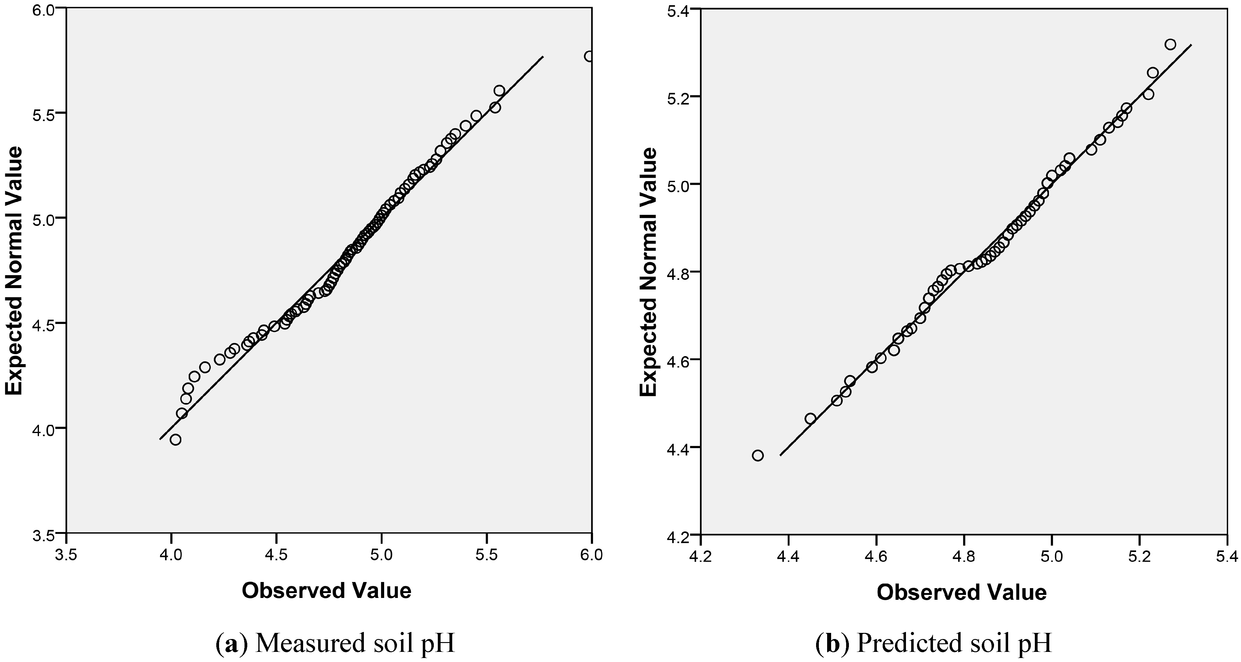
2.1. Summary Statistics
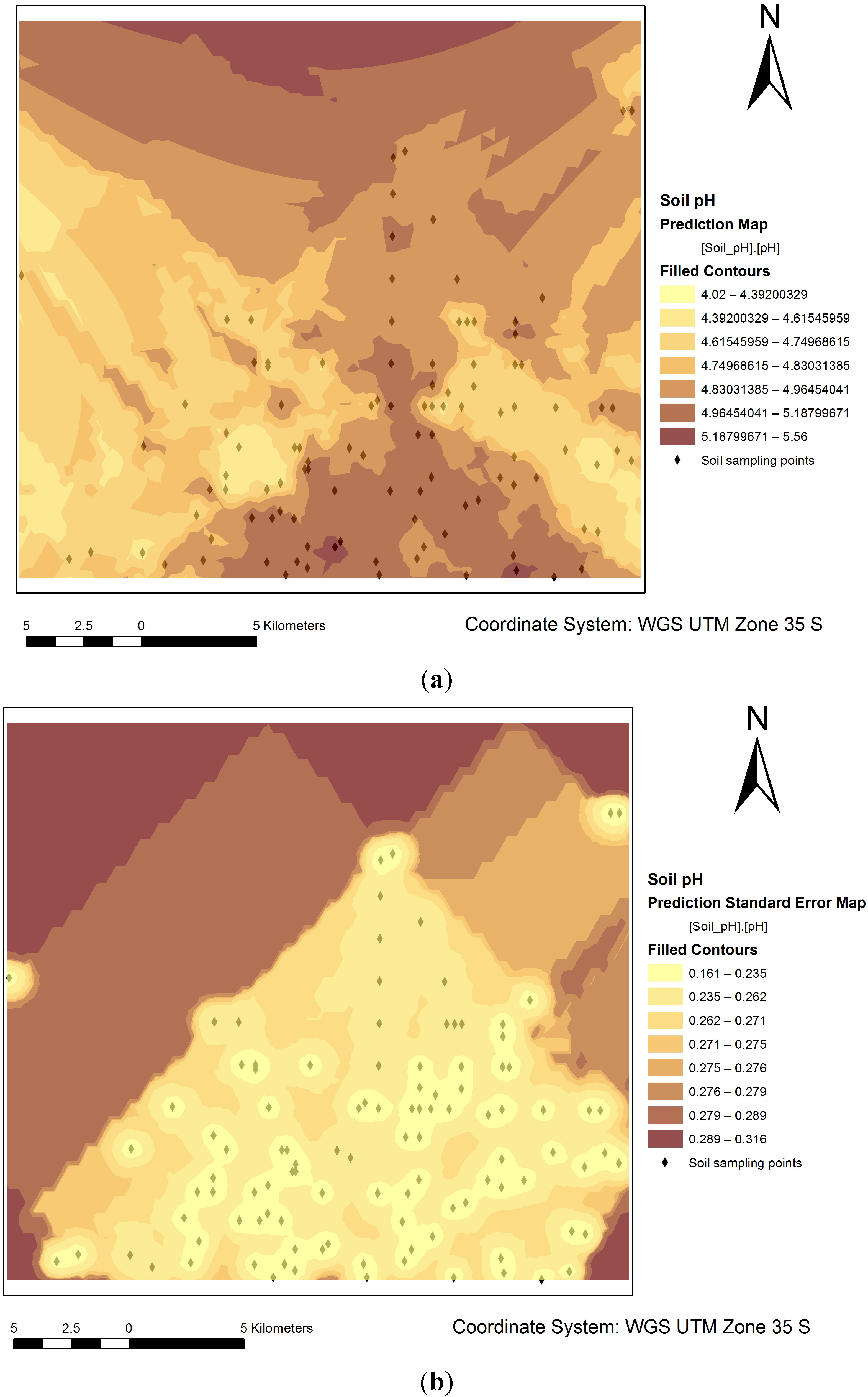
2.2. Kriging Interpolated Surface for Soil pH

| Statistic | Measured Soil pH | Predicted Soil pH |
|---|---|---|
| Mean | 4.86 | 4.86 |
| Minimum | 4.02 | 4.33 |
| Maximum | 5.56 | 5.28 |
| Median | 4.88 | 4.88 |
| Standard deviation | 0.34 | 0.18 |
| 1st Quartile | 4.66 | 4.72 |
| 3rd Quartile | 5.08 | 4.98 |
| Skewness | −0.36 | 0.25 |
| Kurtosis | 3.11 | 2.89 |


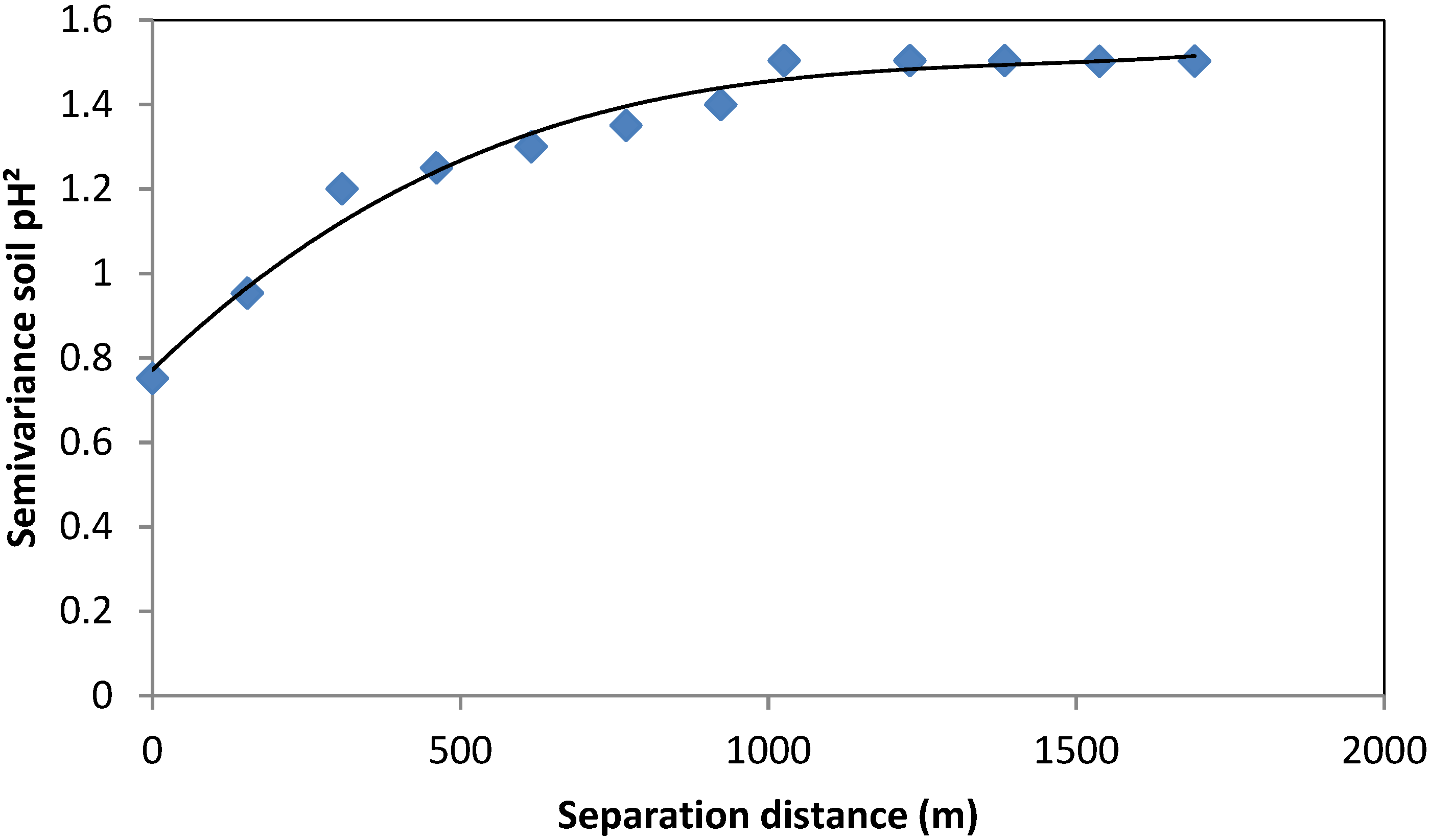
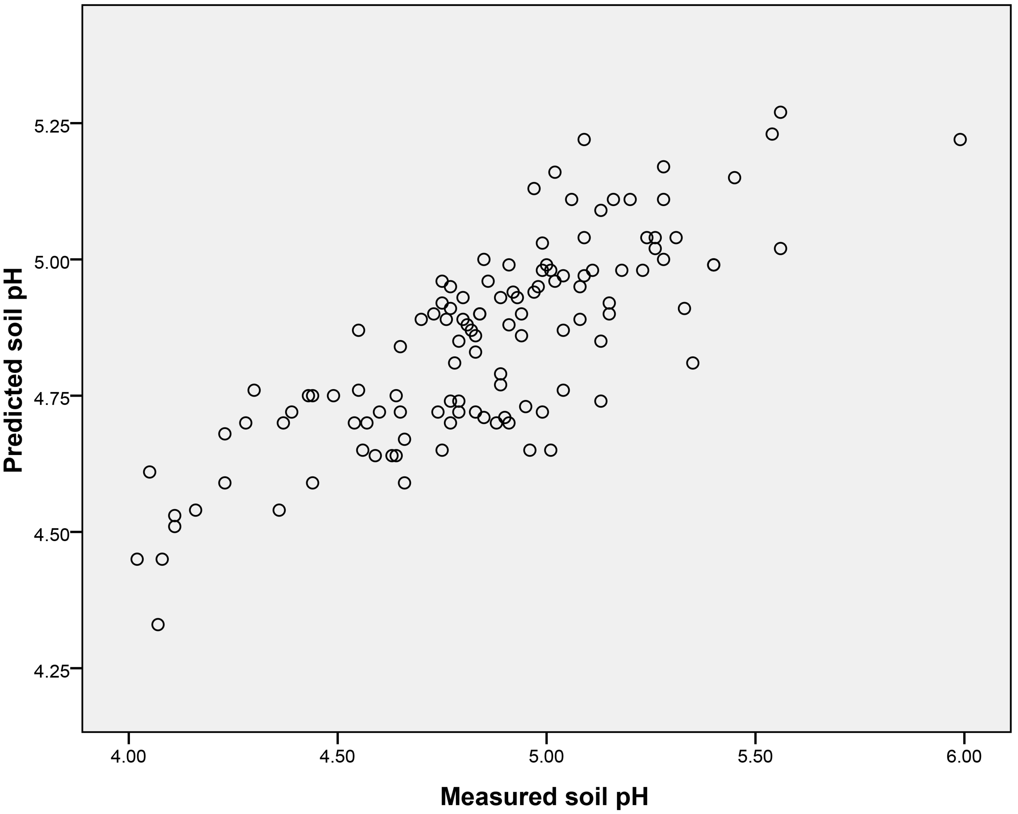
2.3. Spatial Autocorrelation for pH and Model Validation
| Fitted Variogram Parameters | |||||||
|---|---|---|---|---|---|---|---|
| Nugget | Sill | Range (m) | Nugget/Sill Ratio | ||||
| 0.08 | 0.14 | 1379 | 0.57 | ||||
| Prediction Errors for OK Model Implemented to Predict Soil pH | |||||||
| Mean | Mean Standardized | RMSE | Average Standard Error | RMSE Standardized | |||
| −0.004 | −0.008 | 0.36 | 0.39 | 0.93 | |||

2.4. Model Validation

3. Experimental Section
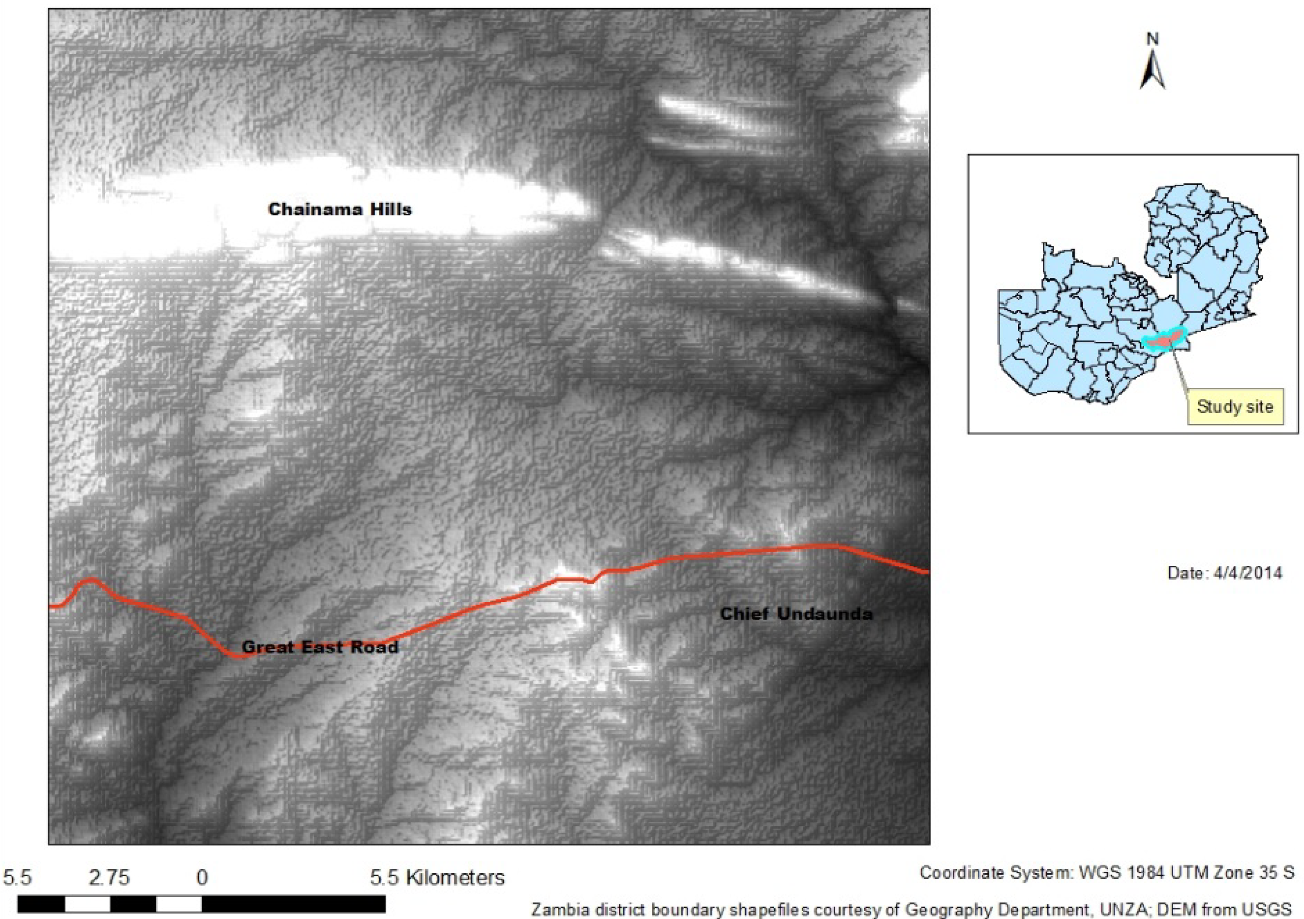
3.1. Study Area

3.2. Soil Sampling and Laboratory Analysis
3.3. Data Pre-Processing and Analysis
3.4. Geostatistical Analysis
3.5. Validation of Spatial Prediction of Soil pH
4. Conclusions
Acknowledgments
Author Contributions
Conflicts of Interest
References
- Caritat, P.; Cooper, M.; Wilford, J. The pH of Australian Soils; Field Results from a National Survey. Soil Res. 2011, 49, 173–182. [Google Scholar] [CrossRef]
- Bickelhaupt, D. What is Soil pH: What It Means. Available online: http://www.esf.edu/pubprog/brochure/soilpH (accessed on 13 January 2014).
- Schirrmann, M.; Gebbers, R.; Seidel, E.K.E. Soil pH Mapping with an On-the-go Sensor. Sensors 2011, 11, 573–598. [Google Scholar] [CrossRef]
- Reuter, H.I.; Lado, L.R.; Hengl, T.; Montanarella, L. Continental—Scale Digital Soil Mapping Using European Soil Profile Data: Soil pH. Hamburger Beitrage zur Physischen Geographie und Landschaftokologie-Heft19. 2008. Available online: http://www.academia.edu/587354/continetal_scale_digital (accessed on 20 January 2014).
- Sheng, J.; Ma, L.; Jiang, P.; Li, B.; Huang, F.; Wu, H. Digital Soil Mapping to Enable Classification of the Salt Affected Soils in Desert Agro-ecological Zones. Agric. Water Manag. 2010, 97, 1944–1951. [Google Scholar] [CrossRef]
- Connolly, J.; Holden, N.M.; Ward, S.M. Mapping Peatlands in Ireland Using a Rule-based Methodology and Digital Data. SSSAJ 2007, 71, 492–499. [Google Scholar] [CrossRef]
- Robinson, T.P.; Metternicht, G. Testing the Performance of Spatial Interpolation Techniques for Mapping Soil Properties. Comput. Electron. Agric. 2006, 50, 97–108. [Google Scholar] [CrossRef]
- Mambo, A.; Phiri, L.K. Soil Acidity Map of Zambia; Zambia Agriculture Research Institute: Lusaka, Zambia, 2004. [Google Scholar]
- Leungthong, O.; McLennan, J.A.; Deutsch, C.V. Minimum Acceptance Criteria for Geostatistical Realizations. Nat. Resourc. Res. 2004, 13, 131–141. [Google Scholar] [CrossRef]
- Chabala, L.M.; Mulolwa, A.; Lungu, O. Landform Classification for Digital Soil Mapping in the Chongwe-Rufunsa Area, Zambia. Agric. For. Fish. 2013, 2, 156–160. [Google Scholar]
- McNeal, E.O. Soil pH measurements. In Methods of Soil Analysis Part 2; Page, A.L, Keeney, D.R., Miller, R.H., Eds.; Soil Science Society of America, Inc.: Madison, WI, USA, 1982. [Google Scholar]
- Burrough, P.A.; McDonnell, R.A. Principles of Geographical Information Systems; Oxford University Press: New York, NY, USA, 2004; p. 190. [Google Scholar]
- Chahouki, M.A.A.; Chahouki, A.Z.; Ahvasi, L.K. Comparing Geostatistical Approaches for Mapping Soil Properties in Poshtkouh Rangelands of Yazd Province, Iran. Vegetos 2011, 24, 77–88. [Google Scholar]
- Johnston, K.; ver Hoef, J.M.; Krivoruchko, K.; Lucas, N. Using ArcGIS Geostatistical Analyst; ESRI Press: Redlands, CA, USA, 2001. [Google Scholar]
- Cambardella, C.A.; Moorma, T.B.; Novak, J.M.; Parkin, T.B.; Karlen, D.L.; Turco, R.F.; Konopka, A.E. Field Scale Variability of Soil Properties in Central Iowa soils. Soil Sci. Soc. Am. J. 1994, 58, 1501–1511. [Google Scholar] [CrossRef]
- Environmental Systems Research Institute (ESRI). ArcGIS Desktop; Environmental Systems Research Institute: Redlands, CA, USA, 2011. [Google Scholar]
© 2014 by the authors; licensee MDPI, Basel, Switzerland. This article is an open access article distributed under the terms and conditions of the Creative Commons Attribution license (http://creativecommons.org/licenses/by/4.0/).
Share and Cite
Chabala, L.M.; Mulolwa, A.; Lungu, O. Mapping the Spatial Variability of Soil Acidity in Zambia. Agronomy 2014, 4, 452-461. https://doi.org/10.3390/agronomy4040452
Chabala LM, Mulolwa A, Lungu O. Mapping the Spatial Variability of Soil Acidity in Zambia. Agronomy. 2014; 4(4):452-461. https://doi.org/10.3390/agronomy4040452
Chicago/Turabian StyleChabala, Lydia M., Augustine Mulolwa, and Obed Lungu. 2014. "Mapping the Spatial Variability of Soil Acidity in Zambia" Agronomy 4, no. 4: 452-461. https://doi.org/10.3390/agronomy4040452