
Comparing Fuzzy Sets and Random Sets to Model the Uncertainty of Fuzzy Shorelines


Abstract
:
1. Introduction
2. Methodology
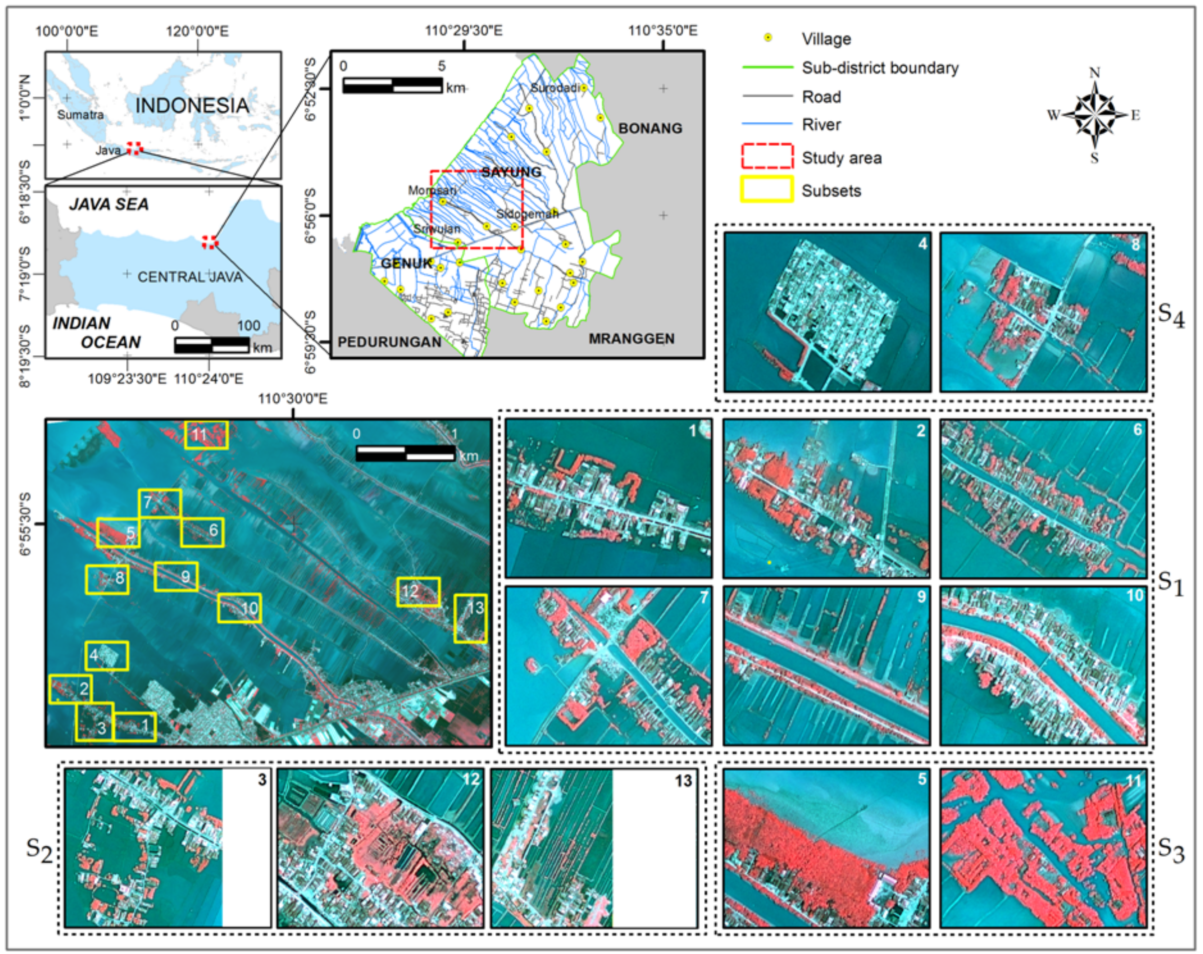
2.1. Study Area
2.2. Dataset
2.3. Pre-Processing
- is a mix of settlements and vegetation. This group consists of six subsets. They have a similar land orientation, stretching from northwest to southeast direction indicating rural settlements with a strip land surrounded by inundated fishponds. Rivers with various widths divide each island into two sides and small roads are found on either sides of the river. Rural settlements are mostly concentrated alongside the roads with sparse vegetation coverage.
- is a mix of settlement and vegetation with more complex composition. Small rivers are clearly seen in and . Fishponds with irregular shapes are visible at the northern part of and .
- is dominated by vegetation coverage. Rural settlements are visible in along the river side and a wide muddy area can be found in the northern part of the subset close to the mangrove area.
- shows rural settlements surrounded by inundated fishponds. The settlements are protected by concrete embankment.
2.4. Modelling Shoreline Using Fuzzy Sets
2.4.1. FCM Classification
2.4.2. Image Segmentation
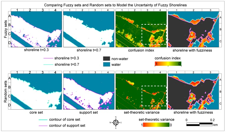
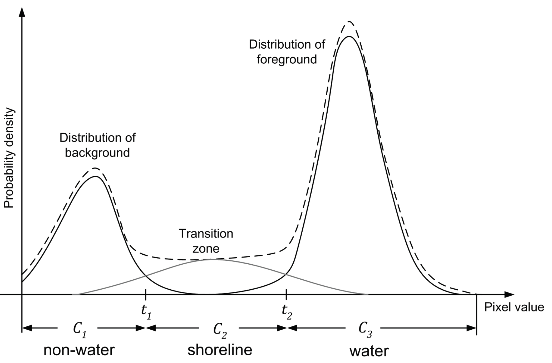
2.4.3. Uncertainty Estimation
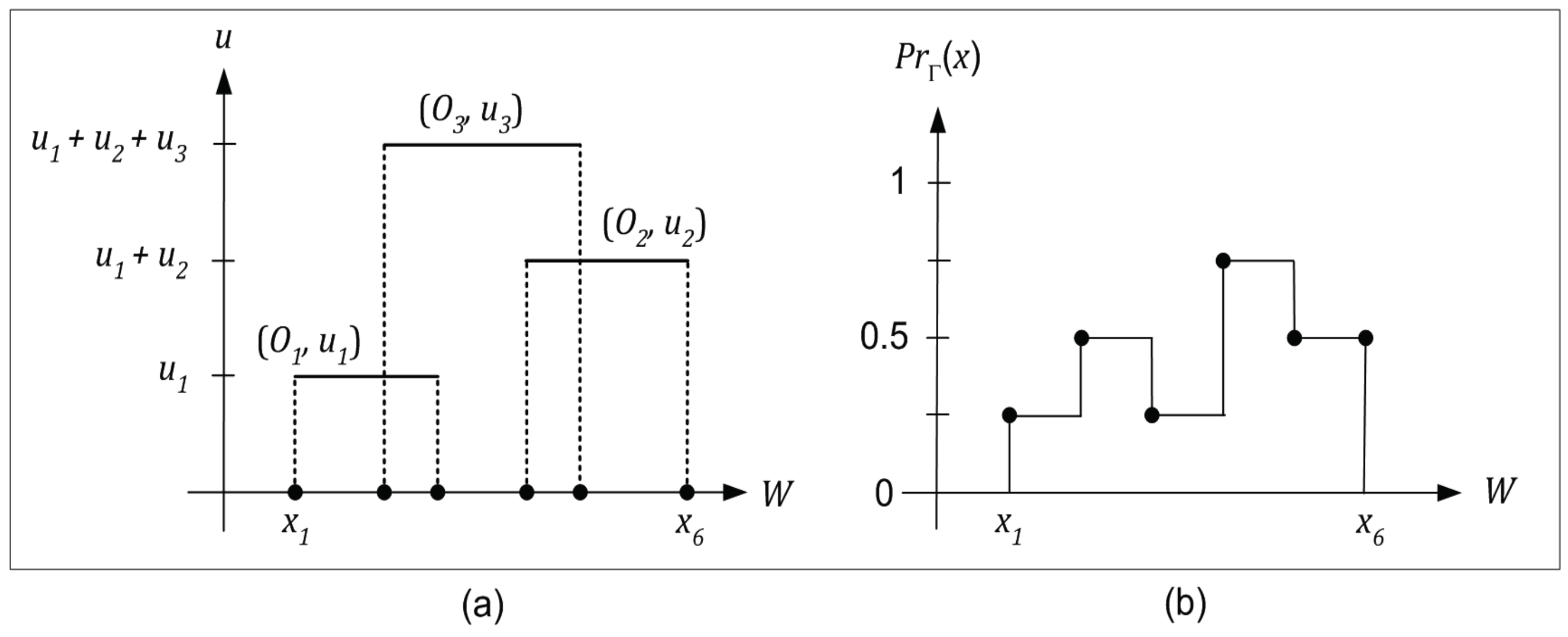
2.5. Modelling Shoreline by Random Sets
2.5.1. Parameter Estimation of Random Sets
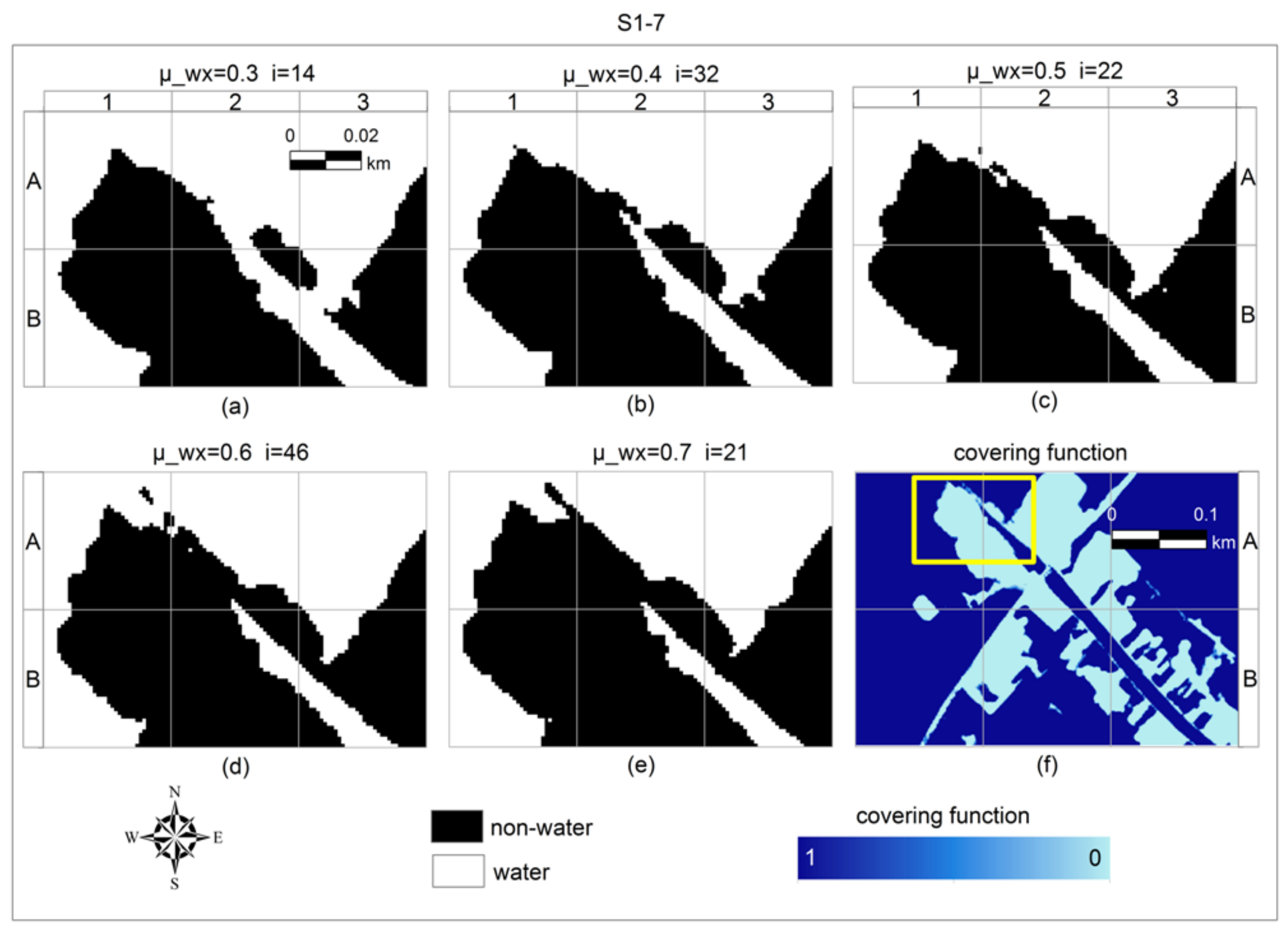
2.5.2. Modelling the Extent of Shoreline by Random Sets
2.6. Validation and Comparing Classification Performance
3. Results
3.1. Modelling Shoreline Using Fuzzy Sets
3.1.1. Parameter Estimation of FCM Classification
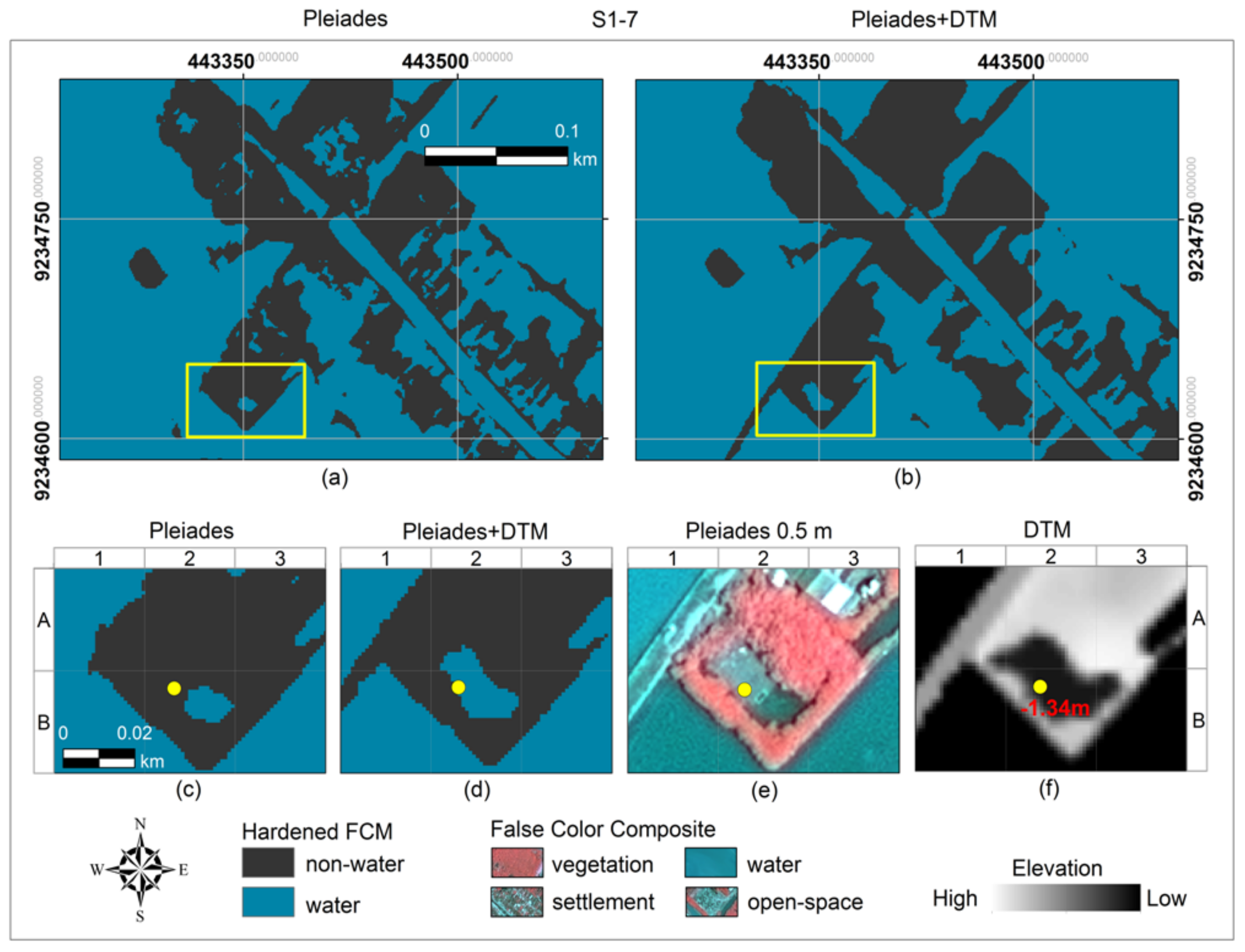
3.1.2. Hardened FCM and Accuracy Comparison
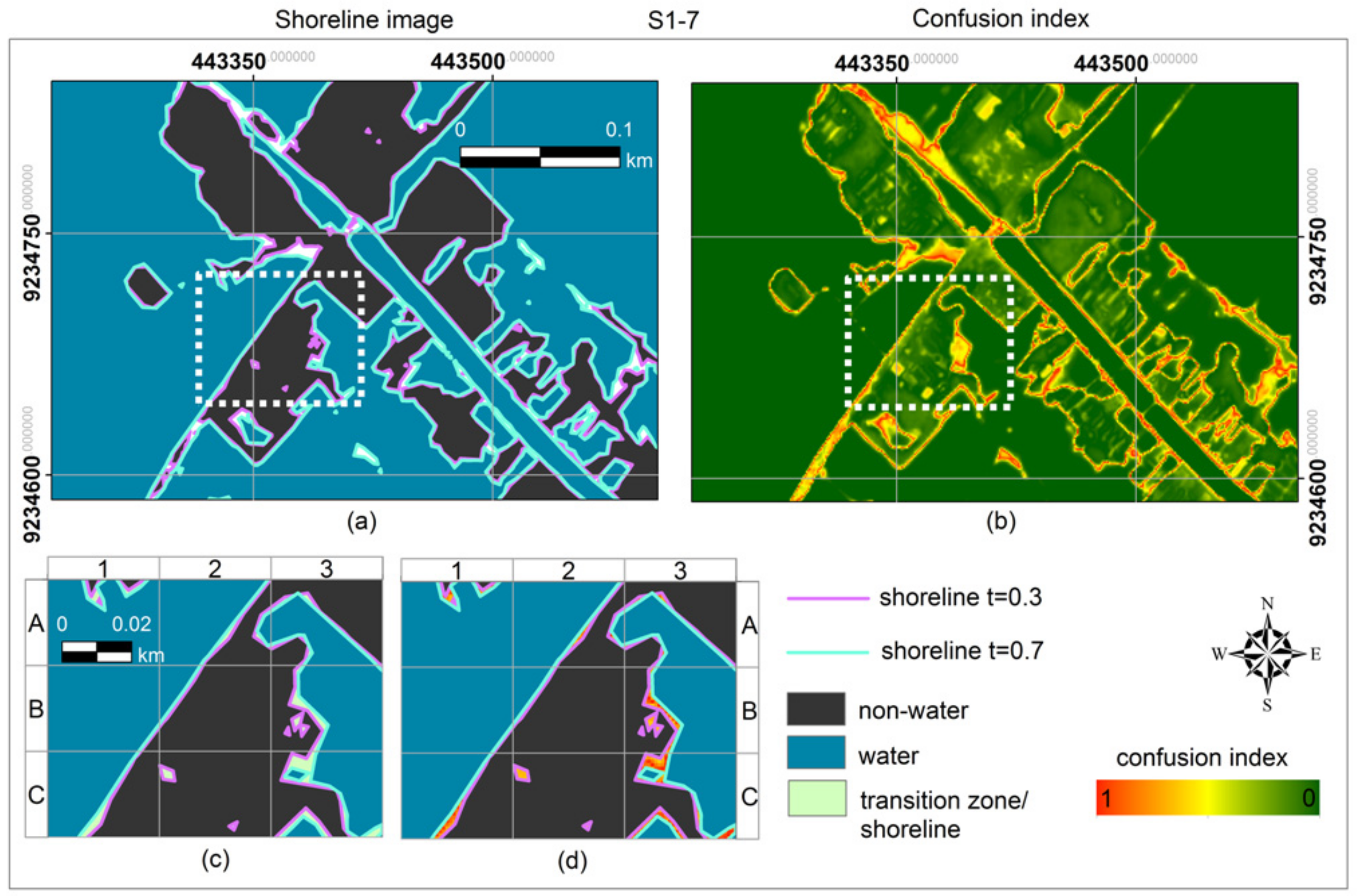
3.1.3. Fuzzy Shoreline and Uncertainty Estimation
3.2. Modelling Shoreline by Random Sets
3.2.1. Parameter Estimation Results
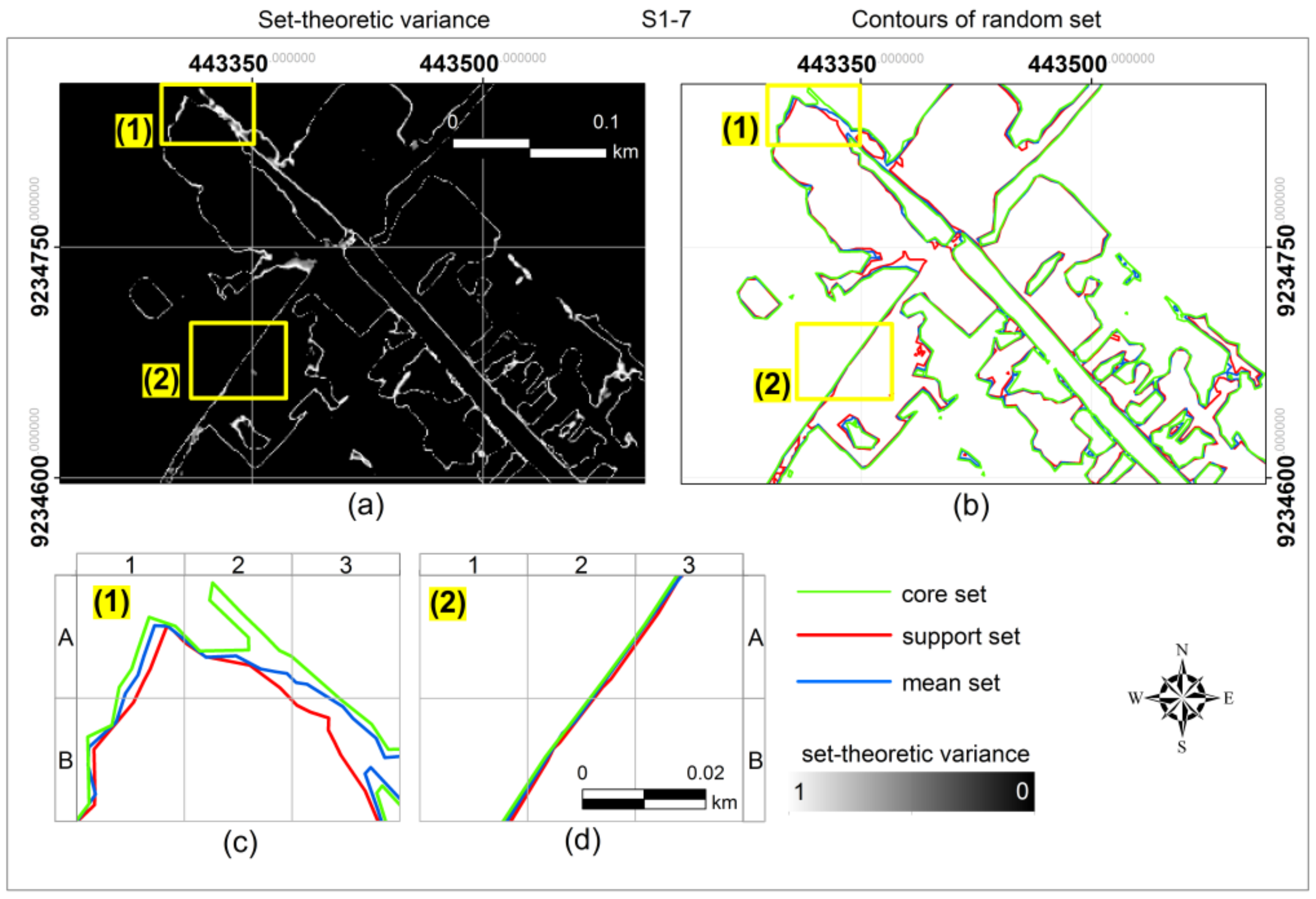
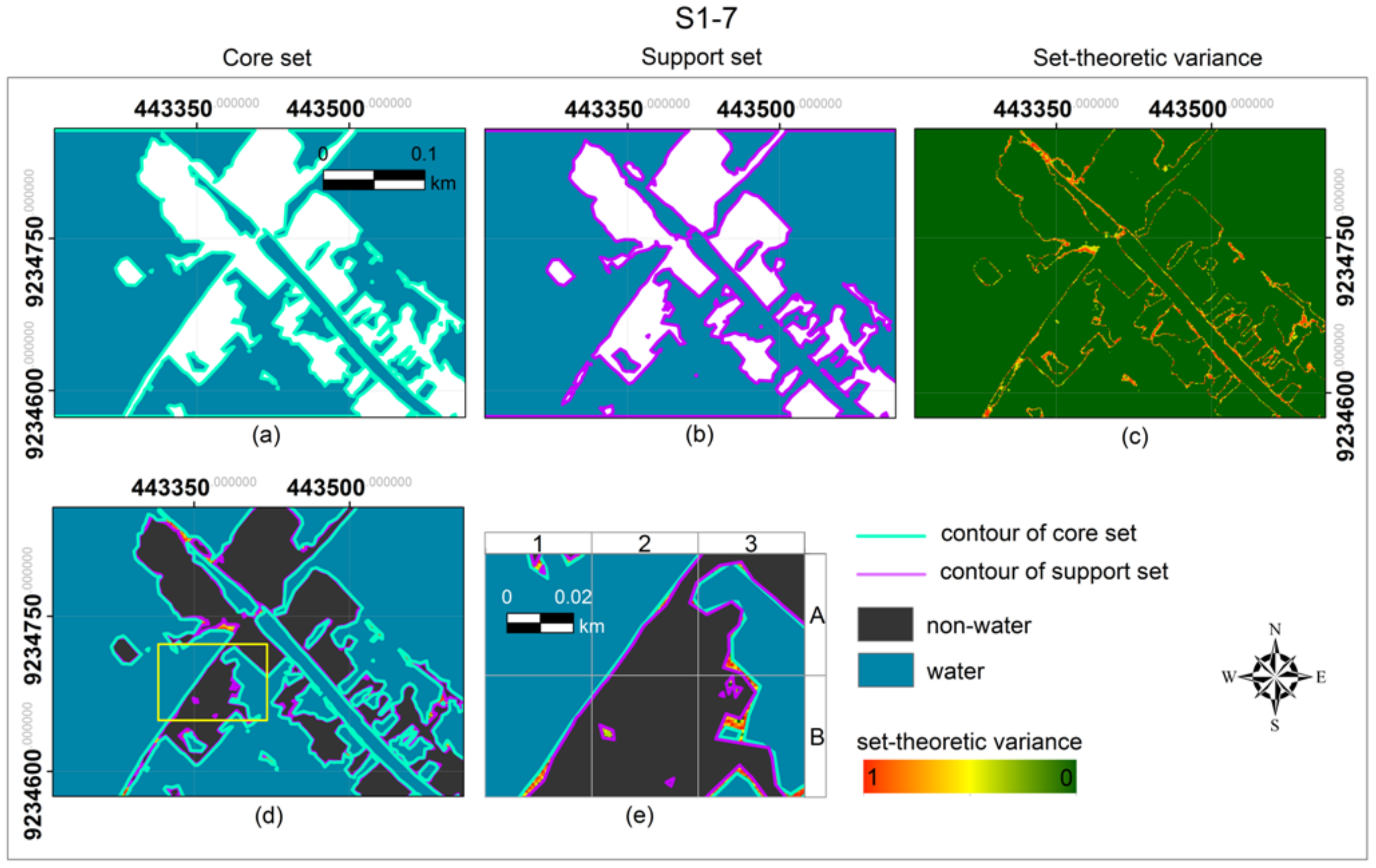
3.2.2. Uncertainty Modelling of Shoreline Objects
3.2.3. Accuracy Assessment of Random Sets Results
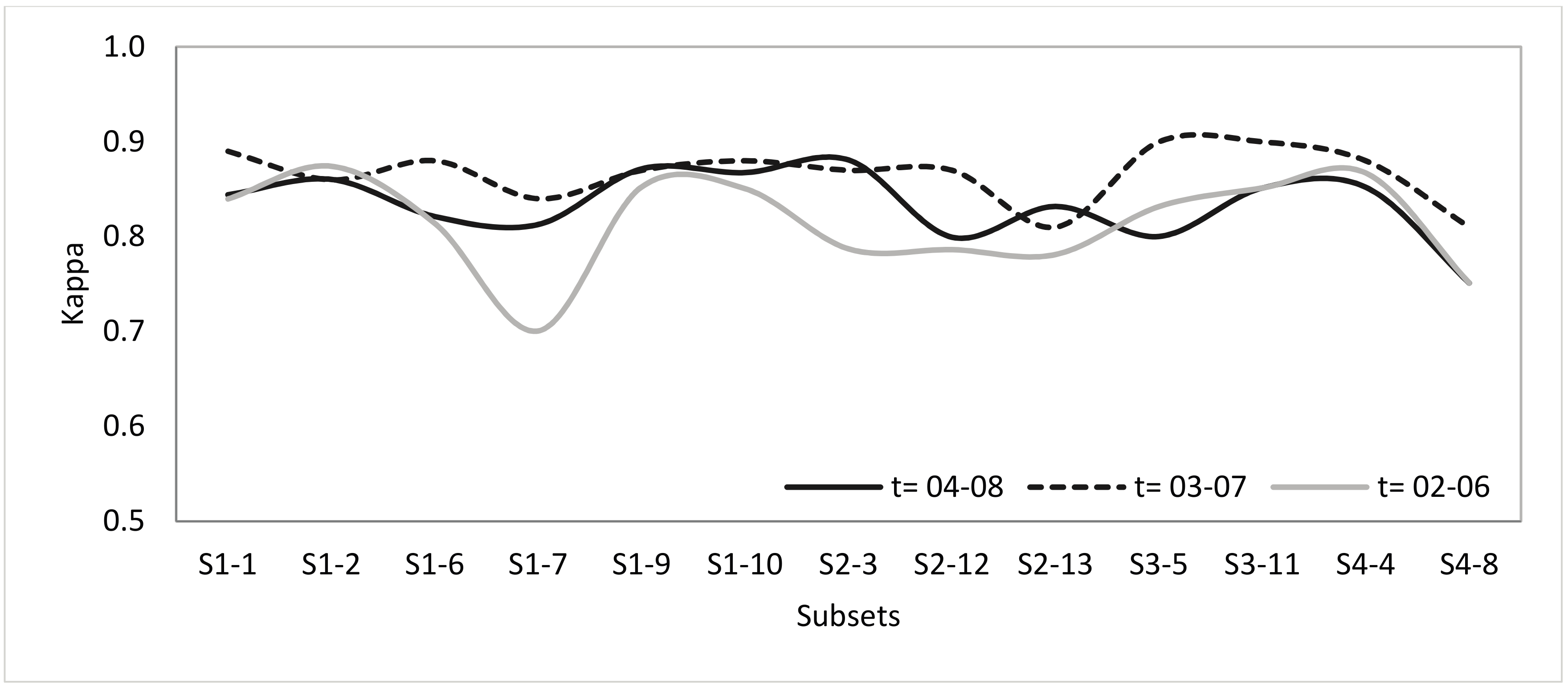
3.3. Comparing Classification Performance
4. Discussion
5. Conclusions
Supplementary Materials
Acknowledgments
Author Contributions
Conflicts of Interest
References
- Zhao, X.; Stein, A.; Chen, X.-L. Monitoring the dynamics of wetland inundation by random sets on multi-temporal images. Remote Sens. Environ. 2011, 115, 2390–2401. [Google Scholar] [CrossRef]
- Jay, S.; Guillaume, M. A novel maximum likelihood based method for mapping depth and water quality from hyperspectral remote-sensing data. Remote Sens. Environ. 2014, 147, 121–132. [Google Scholar] [CrossRef]
- Hereher, M.E. Mapping coastal erosion at the Nile Delta western promontory using Landsat imagery. Environ. Earth Sci. 2011, 64, 1117–1125. [Google Scholar] [CrossRef]
- Dewi, R.S.; Bijker, W.; Stein, A. Change Vector Analysis to Monitor the Changes in Fuzzy Shorelines. Remote Sens. 2017, 9, 147. [Google Scholar] [CrossRef]
- Dewi, W.S.; Bijker, W.; Stein, A.; Marfai, M.A. Fuzzy Classification for Shoreline Change Monitoring in a Part of the Northern Coastal Area of Java, Indonesia. Remote Sens. 2016, 8, 190. [Google Scholar] [CrossRef]
- Sukcharoenpong, A.; Yilmaz, A.; Li, R. An Integrated Active Contour Approach to Shoreline Mapping Using HSI and DEM. IEEE Trans. Geosci. Remote Sens. 2016, 54, 1586–1597. [Google Scholar] [CrossRef]
- Dewan, A.; Corner, R.; Saleem, A.; Rahman, M.M.; Haider, M.R.; Rahman, M.M.; Sarker, M.H. Assessing channel changes of the Ganges-Padma River system in Bangladesh using Landsat and hydrological data. Geomorphology 2017, 276, 257–279. [Google Scholar] [CrossRef]
- Ouma, Y.O.; Tateishi, R. A water index for rapid mapping of shoreline changes of five East African Rift Valley Lakes: An empirical analysis using Landsat TM and ETM+ Data. Int. J. Remote Sens. 2007, 27, 3153–3181. [Google Scholar] [CrossRef]
- Kuleli, T. Quantitative analysis of shoreline changes at the Mediterranean Coast in Turkey. Environ. Monit. Assess. 2010, 167, 387–397. [Google Scholar] [CrossRef] [PubMed]
- García-Rubio, G.; Huntley, D.; Russell, P. Evaluating shoreline identification using optical satellite images. Mar. Geol. 2015, 359, 96–105. [Google Scholar] [CrossRef]
- Taha, L.G.E.; Elbeih, S.F. Investigation of fusion of SAR and Landsat data for shoreline super resolution mapping: The Northeastern Mediterranean sea coast in Egypt. Appl. Geomat. 2010, 2, 177–186. [Google Scholar] [CrossRef]
- Muslim, A.M.; Foody, G.M.; Atkinson, P.M. Localized soft classification for super-resolution mapping of the shoreline. Int. J. Remote Sens. 2006, 27, 2271–2285. [Google Scholar] [CrossRef]
- Riesch, H. Levels of Uncertainty. In Essentials of Risk Theory; Roeser, S., Hillerbrand, R., Sandin, P., Peterson, M., Eds.; Springer: Dordrecht, The Netherlands, 2013. [Google Scholar]
- Fisher, P.F. Models of uncertainty in spatial data. Geogr. Inf. Syst. 1999, 1, 191–205. [Google Scholar]
- Burrough, P.A.; van Gaans, P.F.M.; Hootsmans, R. Continuous classification in soil survey: Spatial correlation, confusion and boundaries. Geoderma 1997, 77, 115–135. [Google Scholar] [CrossRef]
- Schneider, M. Modeling spatial objects with undetermined boundaries using the realm/rose approach. In Geographic Objects with Indeterminate Boundaries; Burrough, P.A., Frank, A.U., Eds.; Taylor & Francis: London, UK, 1998; pp. 1–12. [Google Scholar]
- Goodman, I.R.; Nguyen, H.T. Uncertainty Models for Knowledge-Based Systems; North Holland: Amsterdam, The Netherlands, 1985. [Google Scholar]
- Skidmore, A.K.; Turner, B.F. Map Accuracy Assessment Using Line Intersect Sampling. Photogramm. Eng. Remote Sens. 1992, 58, 1453–1457. [Google Scholar]
- Couso, I.; Dubois, D.; Sánchez, L. Random Sets and Random Fuzzy Sets as Ill-Perceived Random Variables; Springer: New York, NY, USA, 2014. [Google Scholar]
- Zadeh, L.A. Fuzzy Sets. Inf. Control 1965, 8, 338–355. [Google Scholar] [CrossRef]
- Zadeh, L.A. PRUF a meaning representation language for natural languages. Int. J. Mach. Stud. 1978, 10, 395–460. [Google Scholar] [CrossRef]
- Tso, B.; Mather, P. Classification Methods for Remotely Sensed Data; CRC Press: Boca Raton, FL, USA, 2009. [Google Scholar]
- Robinson, V.B. A Perspective on the Fundamentals of Fuzzy Sets and their Use in Geographic Information Systems. Trans. GIS 2003, 7, 3–30. [Google Scholar] [CrossRef]
- Cheng, T. Fuzzy Objects: Their Changes and Uncertainties. Photogramm. Eng. Remote Sens. 2002, 68, 41–49. [Google Scholar]
- Dunn, J.C. A Fuzzy Relative of the ISODATA Process and Its Use in Detecting Compact Well-Separated Clusters. Cybern. Syst. 1973, 3, 32–57. [Google Scholar] [CrossRef]
- Bezdek, J.C.; Ehrlich, R.; Full, W. FCM: The fuzzy c-means clustering algorithm. Comput. Geosci. 1984, 10, 191–203. [Google Scholar] [CrossRef]
- Zhang, J.; Foody, G.M. A fuzzy classification of sub-urban land cover from remotely sensed imagery. Int. J. Remote Sens. 1998, 19, 2721–2738. [Google Scholar] [CrossRef]
- Cheng, T.; Molenaar, M.; Lin, H. Formalizing fuzzy objects from uncertain classication results. Int. J. Geogr. Inf. Sci. 2001, 15, 27–42. [Google Scholar] [CrossRef]
- Vlag, D.E.V.D.; Stein, A. Incorporating Uncertainty via Hierarchical Classification Using Fuzzy Decision Trees. IEEE Trans. Geosci. Remote Sens. 2007, 45. [Google Scholar] [CrossRef]
- Dilo, A.; By, R.A.D.; Stein, A. A system of types and operators for handling vague spatial objects. Int. J. Geogr. Inf. Sci. 2007, 21, 397–426. [Google Scholar] [CrossRef]
- Liu, K.; Shi, W.; Zhanga, H. A fuzzy topology-based maximum likelihood classification. ISPRS J. Photogramm. Remote Sens. 2011, 66, 103–114. [Google Scholar] [CrossRef]
- Schneider, M. Fuzzy Topological Predicates, Their Properties, and Their Integration into Query Languages. In Proceedings of the 9th ACM International Symposium on Advances in Geographic Information Systems, Atlanta, GA, USA, 9–11 November 2001; ACM Digital Library: Atlanta, GA, USA, 2001; pp. 9–14. [Google Scholar]
- Matheron, G. Random Sets and Integral Geometry; John Wiley and Sons: New York, NY, USA, 1975. [Google Scholar]
- Nguyen, H.T. An Introduction to Random Sets; Chapman & Hall/CRC: Boca Raton, FL, USA, 2006. [Google Scholar]
- Molchanov, I. Theory of Random Sets; Springer: London, UK, 2005. [Google Scholar]
- Epifanio, I.; Soille, P. Morphological Texture Features for Unsupervised and Supervised Segmentations of Natural Landscapes. IEEE Trans. Geosci. Remote Sens. 2007, 45, 1074–1083. [Google Scholar] [CrossRef]
- Stoyan, D.; Stoyan, H. Fractals, Random Shapes and Point Fields: Methods of Geometrical Statistics; John Wiley and Sons: Chichester, UK, 1994. [Google Scholar]
- Zhou, L.; Stein, A. Application of random sets to model uncertainty of road polygons extracted from airborne laser points. Comput. Environ. Urban Syst. 2013, 41, 289–298. [Google Scholar] [CrossRef]
- Zadeh, L.A. Discussion: Probability Theory and Fuzzy Logic Are Complementary Rather Than Competitive. Technometrics 1995, 37, 271–276. [Google Scholar] [CrossRef]
- Nguyen, H.T.; Wu, B. Random and fuzzy sets in coarse data analysis. Comput. Stat. Data Anal. 2006, 51, 70–85. [Google Scholar] [CrossRef]
- Goodman, I.R.; Mahler, R.P.S.; Nguyen, H.T. Mathematics of Data Fusion; Springer: Dordrecht, The Netherlands, 1997. [Google Scholar]
- Singpurwalla, N.D.; Booker, J.M. Membership Functions and Probability Measures of Fuzzy Sets. J. Am. Stat. Assoc. 2004, 99, 867–877. [Google Scholar] [CrossRef]
- Mahler, R.P.S. Statistical Multisource-Multitarget Information Fusion; Artech House: Norwood, MA, USA, 2007. [Google Scholar]
- Goodman, I.R. Some New Results Concerning Random Sets and Fuzzy Sets. Inf. Sci. 1984, 34, 93–113. [Google Scholar] [CrossRef]
- BIG Online Tidal Prediction. Available online: http://tides.big.go.id/ (accessed on 3 December 2016).
- Chaussard, E.; Amelung, F.; Abidin, H.; Hong, S.-H. Sinking cities in Indonesia: ALOS PALSAR detects rapid subsidence due to groundwater and gas extraction. Remote Sens. Environ. 2013, 128, 150–161. [Google Scholar] [CrossRef]
- Sofian, I. Scientific Basis: Analysis and Projection of Sea Level Rise and Extreme Event; National Development Planning Agency: Bappenas, Indonesia, 2010. [Google Scholar]
- Dames, T.W.G. The Soils of East Central Java; The General of Agricultural Research Station: Bogor, Indonesia, 1955. [Google Scholar]
- BPS. Regional Statistics of Sayung Subdistrict in 2015; Central Bureau of Statistics of Demak Regency: Central Java, Indonesia, 2015. [Google Scholar]
- Rondonuwu, C. The Sinking of Bedono. Available online: https://www.ekuatorial.com/2010/11/the-sinking-of-bedono/#!/story=post-6051&loc=-1.625758360412755,119.43237304687499,4 (accessed on 2 August 2017).
- Hartini, S. Flood Risk Modelling on Agricultural Area in the North Coastal Area of Central Java. Ph.D. Thesis, Gadjah Mada University, Yogyakarta, Indonesia, 2015. [Google Scholar]
- Marfai, M.A.; King, L. Tidal inundation mapping under enhanced land subsidence in Semarang, Central Java Indonesia. Nat. Hazards 2008, 44, 93–109. [Google Scholar] [CrossRef]
- Harwitasari, D.; van Ast, J.A. Climate change adaptation in practice: People’s responses to tidal flooding in Semarang, Indonesia. J. Flood Risk Manag. 2011, 4, 216–233. [Google Scholar] [CrossRef]
- Winterwerp, H.; Wesenbeeck, B.V.; Dalfsen, J.V.; Tonneijck, F.; Astra, A.; Verschure, S.; Eijk, P.V. A sustainable solution for massive coastal erosion in Central Java. In Discussion Paper; Deltares-Wetland International: Delft, The Netherlands, 2014; pp. 1–45. [Google Scholar]
- Anonymous. Control Points (GCP and ICP) Measurement Completion Report; Indonesia Geospatial Information Agency (BIG): Cibinong, Indonesia, 2014. [Google Scholar]
- Pangastuti, D.; Sofian, I. Validation of Geoid EGM2008 in Java and Sumatra by the Parameter Mean Dynamic Topography (MDT) on Geometric Geoid. Maj. Ilm. Globe 2015, 17, 79–88. [Google Scholar]
- Hadjimitsis, D.G.; Papadavid, G.; Agapiou, A.; Themistocleous, K.; Hadjimitsis, M.G.; Retalis, A.; Michaelides, S.; Chrysoulakis, N.; Toulios, L.; Clayton, C.R.I. Atmospheric correction for satellite remotely sensed data intended for agricultural applications: Impact on vegetation indices. Nat. Hazards Earth Syst. Sci. 2010, 10, 89–95. [Google Scholar] [CrossRef]
- Deer, P.J.; Eklund, P. A study of parameter values for a Mahalanobis Distance fuzzy classifier. Fuzzy Sets Syst. 2003, 137, 191–213. [Google Scholar] [CrossRef]
- Xie, X.L.; Beni, G. A validity measure for fuzzy clustering. IEEE Trans. Pattern Anal. Mach. Intell. 1991, 13, 841–847. [Google Scholar] [CrossRef]
- Tobias, O.J.; Seara, R. Image Segmentation by Histogram Thresholding Using Fuzzy Sets. IEEE Trans. Image Process. 2002, 11, 1457–1465. [Google Scholar] [CrossRef] [PubMed]
- Shi, W.; Liu, K.; Huang, C. A Fuzzy-Topology-Based Area Object Extraction Method. IEEE Trans. Geosci. Remote Sens. 2010, 48, 147–154. [Google Scholar]
- Zhao, X.; Stein, A.; Chen, X. Application of random sets to model uncertainties of natural entities extracted from remote sensing images. Stoch. Environ. Res. Risk Assess. 2010, 24, 713–723. [Google Scholar] [CrossRef]
- Leeuw, J.D.; Jia, H.; Yang, L.; Liu, X.; Schmidt, K.; Skidmore, A.K. Comparing accuracy assessments to infer superiority of image classification methods. Int. J. Remote Sens. 2006, 27, 223–232. [Google Scholar] [CrossRef]
- Manandhar, R.; Odeh, I.O.A.; Ancev, T. Improving the Accuracy of Land Use and Land Cover Classification of Landsat Data Using Post-Classification Enhancement. Remote Sens. 2009, 1, 330–344. [Google Scholar] [CrossRef]
- Foody, G.M. Thematic Map Comparison: Evaluating the Statistical Significance of Differences in Classification Accuracy. Photogramm. Eng. Remote Sens. 2004, 70, 627–633. [Google Scholar] [CrossRef]
- Burrough, P.A. Natural object with indeterminate boundaries. In Geographic Object with Indeterminate Boundaries; Burrough, P.A., Frank, A.U., Eds.; Taylor & Francis: Abingdon, UK, 1996. [Google Scholar]
- Zhao, X.; Stein, A.; Chen, X.; Zhang, X. Quantification of Extensional Uncertainty of Segmented Image Objects by Random Sets. IEEE Trans. Geosci. Remote Sens. 2011, 49, 2548–2557. [Google Scholar] [CrossRef]


| Acquisition Date | 27 February 2013 |
| Acquisition time | 03:04 UTC |
| Incidence angle (deg) | 13.66 |
| Sun elevation (deg) | 62.51 |
| Resolution (m) | 0.5 (pan-sharpened product) |
| Bands (μm) | blue (0.43–0.55), green (0.50–0.62), red (0.59–0.71), NIR (0.74–0.94) |
| Map projection | UTM WGS84 |
| Definition | Equations |
|---|---|
| The -level set: to describe the spatial distribution of the varying sizes of | |
| The core set: to describe the certain part of | |
| The median set: to describe the 0.5-level set | |
| The support set: to describe the possible part of | |
| The mean area of | |
| The mean set of | |
| The set-theoretic variance | |
| The sum of variance SV | |
| The coefficient of variation CV |
| Subset | Pleiades | Pleaides + DTM |
|---|---|---|
| 0.77 | 0.86 | |
| 0.62 | 0.86 | |
| 0.76 | 0.88 | |
| 0.48 | 0.84 | |
| 0.56 | 0.87 | |
| 0.74 | 0.88 | |
| 0.74 | 0.91 | |
| 0.74 | 0.87 | |
| 0.78 | 0.87 | |
| 0.50 | 0.82 | |
| 0.74 | 0.89 | |
| 0.65 | 0.88 | |
| 0.67 | 0.81 |
| Subset | SV | CV |
|---|---|---|
| 657 | 0.007 | |
| 811 | 0.009 | |
| 915 | 0.010 | |
| 901 | 0.010 | |
| 466 | 0.005 | |
| 574 | 0.008 | |
| 953 | 0.009 | |
| 1525 | 0.032 | |
| 1710 | 0.017 | |
| 1490 | 0.025 | |
| 883 | 0.014 | |
| 441 | 0.005 | |
| 580 | 0.006 |
| Subset | Pleiades | Pleiades + DTM |
|---|---|---|
| 0.76 | 0.89 | |
| 0.58 | 0.86 | |
| 0.76 | 0.88 | |
| 0.48 | 0.84 | |
| 0.56 | 0.87 | |
| 0.74 | 0.88 | |
| 0.75 | 0.87 | |
| 0.74 | 0.87 | |
| 0.79 | 0.81 | |
| 0.56 | 0.90 | |
| 0.77 | 0.90 | |
| 0.66 | 0.88 | |
| 0.67 | 0.81 |
© 2017 by the authors. Licensee MDPI, Basel, Switzerland. This article is an open access article distributed under the terms and conditions of the Creative Commons Attribution (CC BY) license (http://creativecommons.org/licenses/by/4.0/).
Share and Cite
Dewi, R.S.; Bijker, W.; Stein, A. Comparing Fuzzy Sets and Random Sets to Model the Uncertainty of Fuzzy Shorelines. Remote Sens. 2017, 9, 885. https://doi.org/10.3390/rs9090885
Dewi RS, Bijker W, Stein A. Comparing Fuzzy Sets and Random Sets to Model the Uncertainty of Fuzzy Shorelines. Remote Sensing. 2017; 9(9):885. https://doi.org/10.3390/rs9090885
Chicago/Turabian StyleDewi, Ratna Sari, Wietske Bijker, and Alfred Stein. 2017. "Comparing Fuzzy Sets and Random Sets to Model the Uncertainty of Fuzzy Shorelines" Remote Sensing 9, no. 9: 885. https://doi.org/10.3390/rs9090885