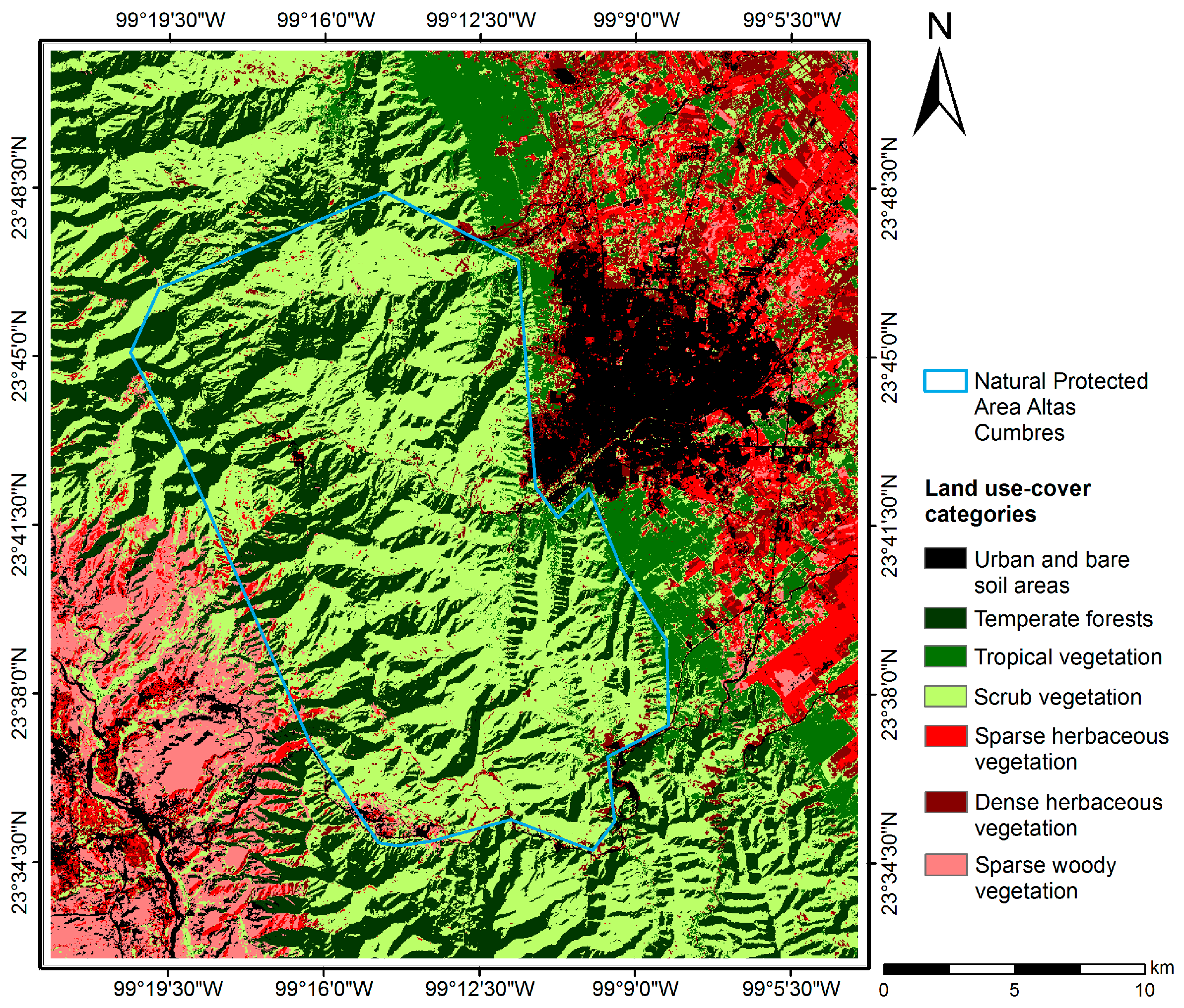
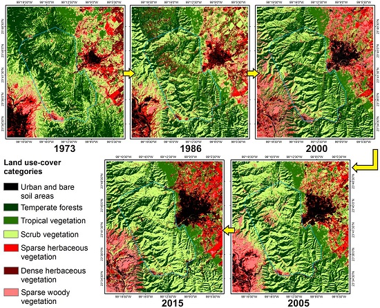
4.1. Land Use-Cover Changes within the Natural Protected Area Altas Cumbres and Its Adjacent Area
The lowest values of the accuracy in the classification and Kappa index were obtained for the MSS image of 1973; this may have been because of its lower spatial resolution compared to the ETM and OLI images. It may generate confusion in the spectral signature of categories, and complicate classification [
4]. However, assessment and classification of the years/stages considered in our study (including the scene of 1973) are reliable, since percentages of overall accuracy were higher than 85% [
61] and Kappa index values were close to 1.0 [
58]. Therefore, these results support both the land use-change and successional analysis herein conducted.
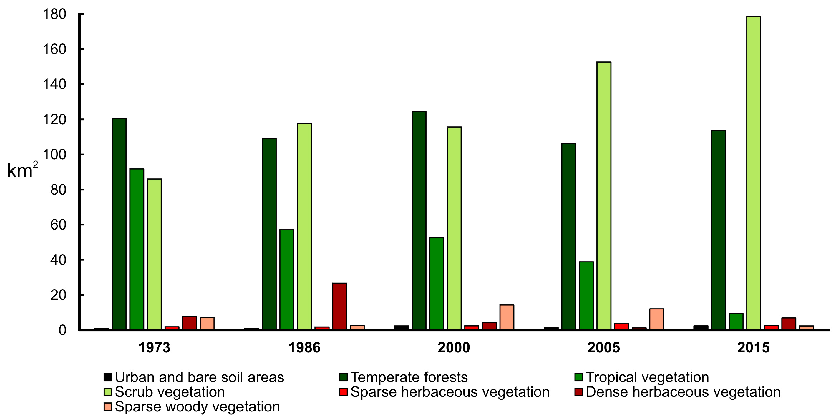
The largest proportion of the area within the NPAAC polygon in 2015 corresponded to Native Temperate forests and Scrub vegetation with persistence since 1973, suggesting that extensive areas of several types of vegetation included in both categories (such as pine, oak, and pine-oak forests, as well as submontane scrub, amongst others), are well preserved. Nevertheless, large areas of Temperate forests and other categories showed a gradual transition to Scrub vegetation, with an appreciable decrease in Tropical vegetation cover from 1973 to 2015. These results agree with regional tendencies observed in Mexico, since change rate and loss of vegetal cover in Temperate forests is much lower than that for Tropical forests [
40]. This reduction in native vegetal cover is not exclusive from our study region; it is rather a worldwide pattern [
6] that has increased in recent years in NPAs and different areas from other countries [
8,
9,
62,
63]. Although the causes of these changes were not assessed in this work, recent studies on LULCC [
12,
25,
26] that include the evaluation of NPAs [
27,
28] and their surrounding areas [
31] have shown that deforestation due to overexploitation, uncontrolled logging, agricultural activities, consumer demand, fires, pests, and urban growth, as well as natural phenomena arising from climate change, are some of the main factors that influence the loss of vegetation in Mexico [
2]. In other areas, the increase in land cover changes has been caused by the rapid population growth, the multiplication of human settlements, and regional economic development [
8,
9,
10,
64]. Likewise, the highest percentages of change and transition occurred between 1973, 1986 and 2000, coincide with a period of high deforestation in Mexico [
34,
40], as proposed in one of the hypotheses raised in this work. However, contrary to our second hypothesis, there was a significant decrease of Tropical vegetation within the NPAAC from 2005 to 2015, even though the official decree in 1997 [
41] suggested that modification rates from 2000 onwards would be lower. Inefficiency of NPAs to contain and prevent LULCC has been observed previously in other areas in Mexico [
29], but it is possible that the recent creation of an official management plan for the NPAAC [
33,
42] will contribute to a future decline in LULCC. This may need to be evaluated and quantified in the coming years.
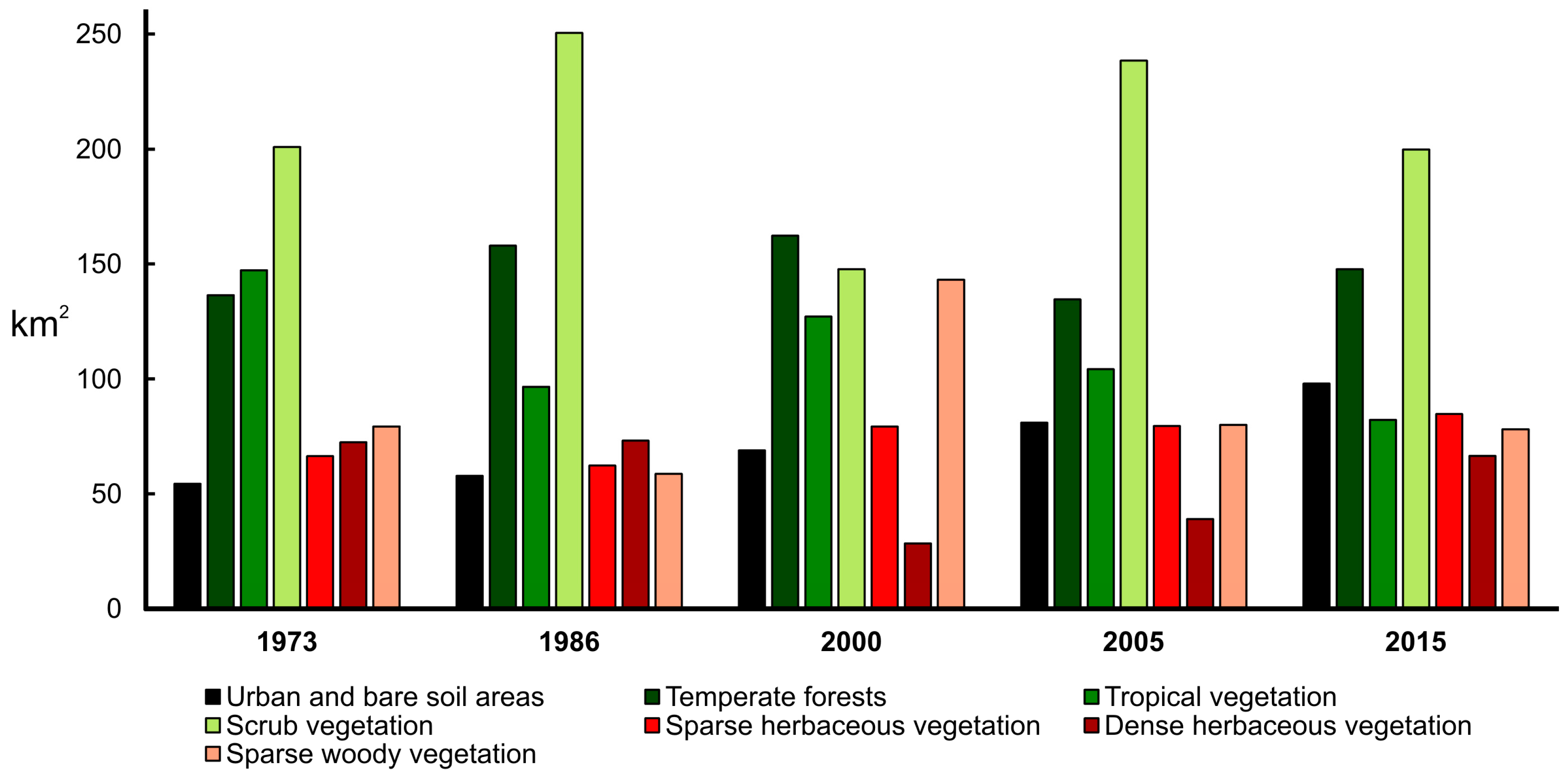
It has been documented that LULCC occurring in adjacent areas of NPAs are of major transcendence, since habitats and resources that contribute to their functioning are located outside their limits in unprotected areas [
36]. This includes also the presence of urban areas and their influence on the adjacent ecosystems [
11,
36,
63]. Hence, there are certain factors concerning the adjacent areas studied whose influence is considered relevant for the NPAAC. First, agriculture: this activity was well represented during 1973 and 1986, and it was reflected in the large coverage of Dense herbaceous vegetation category in that period. Then, the decline in cultivated areas in 2000 corresponds with the increase in Sparse vegetation categories (herbaceous and woody vegetation) in the same year, and suggests the abandonment of agricultural plantations. However, since 2005, agriculture has started increasing again, and the consequences stemming from this have yet to be assessed. Second, the significant and constant buildup of urban areas from 1973 to 2015 has led to an augmentation of human settlements towards the eastern limits of the NPAAC [
42,
44]. Both results are consistent with tendencies observed in other countries, since the number of agricultural and urban areas has increased in recent years [
9,
62,
63] as a consequence of the raising in food demand due to population growth [
6]. Lastly, the notable decline of Tropical vegetation: in 1973, this category embodied several km
2 of extension towards the north, south, and eastern limits of NPAAC, and also around the main urban area. Nevertheless, the increase in the number of bare areas and areas assigned for urban growth that appeared from 1986 to 2015 caused fragmentation and a significant reduction of this type of vegetation. By 2015, Tropical vegetation was restricted mainly to the skirts of the mountain range, between the western portion of the urban area and the eastern boundary of the NPAAC. Several other patches remaining in nearby areas were rapidly diminishing. Indeed, the increase in fragmentation of vegetation [
8] and land use change are some of the main causes of biodiversity loss worldwide [
6]. Therefore, it is of great relevance that future studies aim at evaluating the state of the current communities, both within and in adjacent areas of the NPAAC, to assess the response of the different vegetation categories to land use changes.
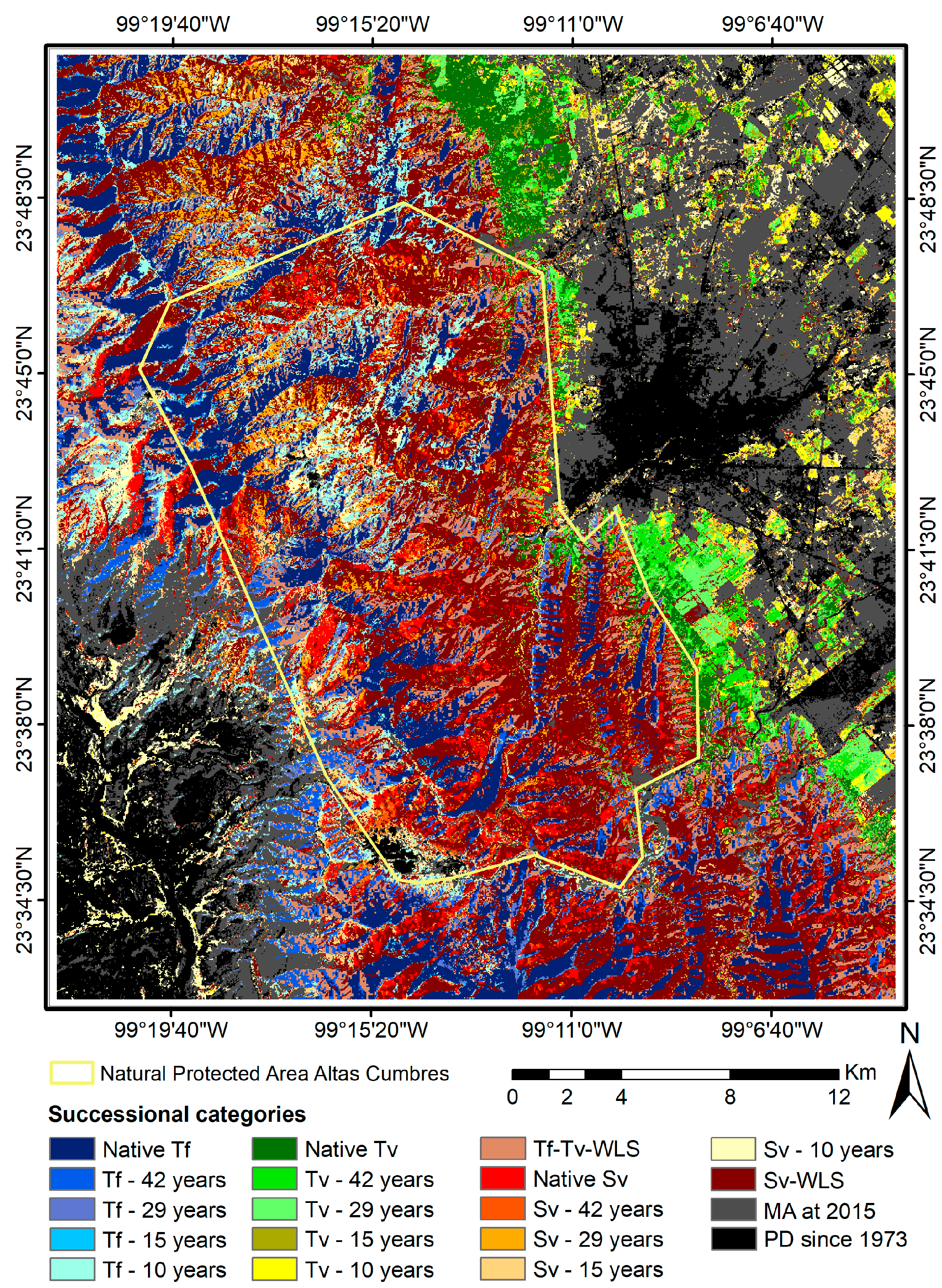
4.2. Successional Stages of the Main Types of Vegetation in the Natural Protected Area Altas Cumbres
The process of secondary succession in vegetal communities is characterized by a modification of vegetation, subsequent to a disturbance [
65,
66,
67], and in the absence of new changes, the disturbed areas over time may present and recover attributes similar to those of the original areas [
68]. Despite the fact that the successional process is not always unidirectional and can follow different routes [
67,
69] and operate according to different causes [
70], for this study we considered the secondary succession only as the process of recovery of vegetation [
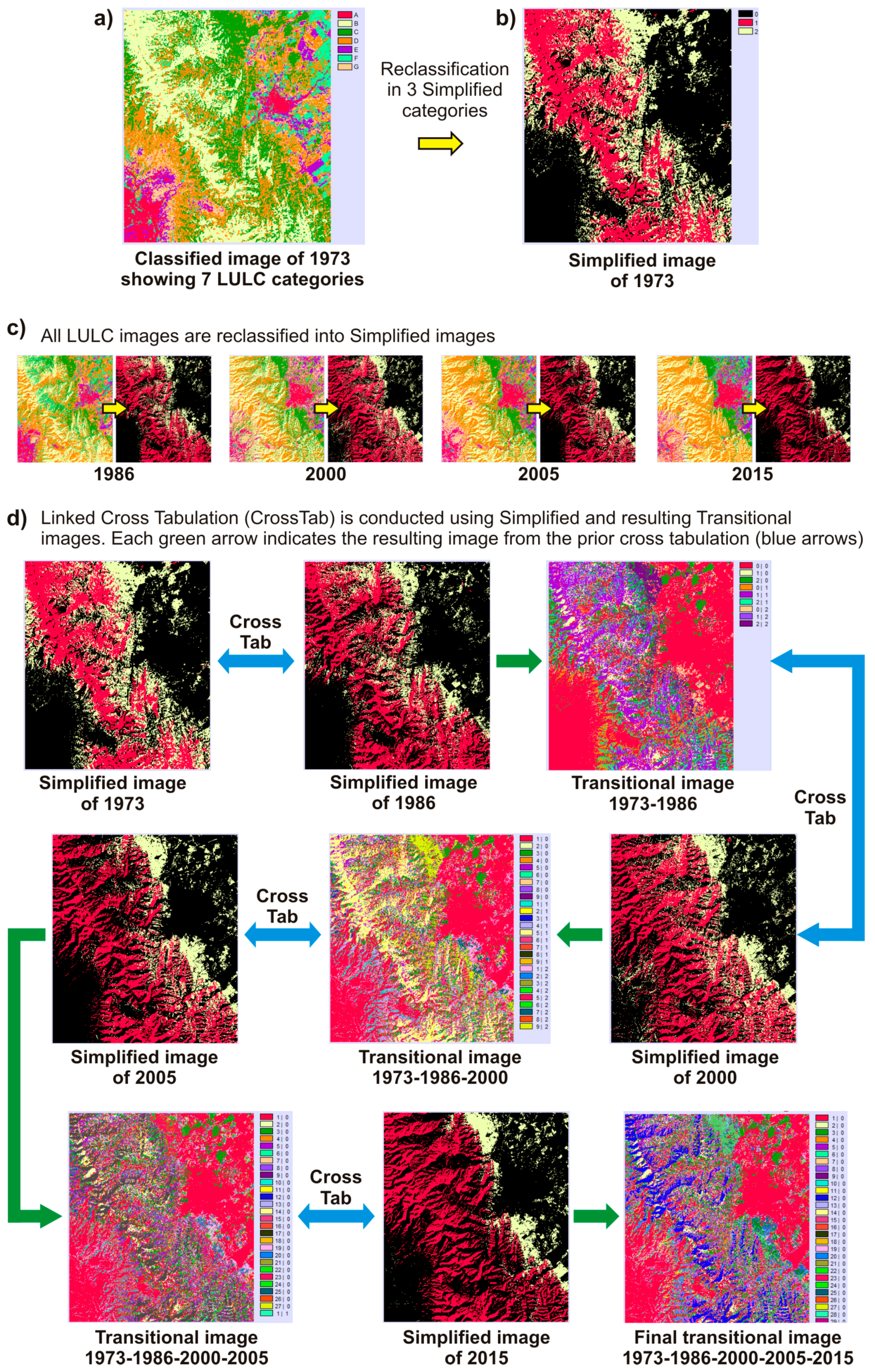
66], without taking into account the route or factors that caused it. Therefore, for this purpose, those areas with modified land cover (for example crops and urban areas), without vegetation (bare soil areas), or characterized by fast-grow pioneer species (grasslands, sparse or dense herbaceous vegetation, among others) were selected as disturbance areas or primary successional stages. Likewise, vegetation types in the category of Scrub vegetation were considered as an initial successional stage for Tropical vegetation and Temperate forests, since it has been observed that development of these communities after disturbance is preceded by scrub vegetation [
59]. Thus, the presence of a disturbed area or an early successional stage in a satellite image, and its transition to Scrub, Tropical vegetation or Temperate forest in the next temporal stage, suggests a recovery process in that zone or pixel analyzed between a temporary stage and another. In this way, it is possible to reconstruct the history of LULCC that occurred or may be occurring in a given area.
The succession processes considered in this work are related to previous evidence of post-disturbance changes in vegetal communities, which have been extensively analyzed worldwide, including in Mexico. After major disturbances where the removal of vegetation was complete, or nearly so [
71], it has been recognized that early stages of succession post disturbance are characterized by dominance of pioneer species such as grasses, shrubs, and other short-lived species [
72,
73]. Therefore, besides the evidently disturbed bare-soil areas, we include the low and dense herbaceous vegetation in the disturbance category as early transition stages for Scrub vegetation, because the abandonment of cultivars, grasslands and other disturbed areas is related to recovery of the vegetation [
74]. In this regard, evidence shows that abandonment of cultivated areas and pasture fields results in the development of thorny vegetation [
75], this being one of the communities considered within the Scrub vegetation in our study. In Mexico, it has been observed that early succession stages are characterized by a dominance of herbaceous and shrubs for both Tropical vegetation [
76] and Temperate forests [
77]. In addition, scrub vegetation exists as an ecotone with areas of these two vegetal communities [
78]. In late succession stages, the transition from shrubs to woody species is a common pattern [
73], and other studies have shown that the increase in successional time favors long-lived and taller trees [
72], resulting in a significant decrease of shrubs [
79]. In summary, this provides ecological evidence for the transition processes considered in our study, in which Scrub vegetation and other categories may precede both Tropical vegetation and Temperate forests in the succession. However, the process of secondary succession is widely recognized as nonlinear [
67,
69,
71], and areas with similar environmental constraints and disturbance conditions, despite being closer to each other, could exhibit very distinct successional trajectories [
80]. We try to overcome this drawback by including both categories of Tropical vegetation-Temperate forests and Scrub vegetation without linear succession, in which we include areas with transitions between different vegetation communities.
The analysis of succession and detection of secondary forests based on multiple layers and scenes of different years has already been used; similarly, other studies have also worked with five or even more temporal stages [
22,
23]. In this sense, the use of Landsat satellite images for the analysis of LULCC is a widely used method [
3,
5,
8,
9,
62], including multitemporal approaches which encompasses several stages [
4,
14,
15,
16,
17,
18,
19,
20,
21,
64,
81]. However, despite the use of five temporal stages (satellite images of 1973, 1986, 2000, 2005 and 2015), it is necessary to recognize the potential limitations of this study, since the disturbances presented between these stages in years not considered could influence the results. For example, an area/pixel categorized with 15 years of succession indicates a category of disturbance in 2000 and the presence of recovered vegetation (Scrub, Tropical or Temperate) in 2005 and 2015. Nevertheless, there may have been disturbance events after 2000 or 2005 that are not considered, and therefore the successional time for such an area in 2015 would be lower. Although it is impossible to determine the exact recovery time, it is guaranteed that the vegetation presents a successional time interval of about 15 years maximum. In addition, the images used as a basis for cross-tabulation presented high values of correct classification, which helps the validation of the succession analysis. It is not excluded, however, that some artifacts could exist (as in any other study) in the classification and validation process that are the basis for our succession analysis. Some of the variations we found in LULC between years could be related to the date of the images, since the scene of 1973 used (it was the only one available) corresponds to the starting wet season, while the others belong to the dry season. Such factors could be related to change patterns of LULC in our study, but it may be of minor relevance for the successional analysis conducted since the seven delimited categories were separated in disturbance and native vegetation for that analysis. For example, it is possible that differences between some areas of Sparse and Dense herbaceous vegetation could not exist, as both are related to agricultural activities; however, both were also included in the disturbance category. Therefore, it does not influence the successional patterns found with our methodological approach. Nevertheless, we suggest that future studies performed in this or any other area could be improved by using more than one image (whenever available) per year of classification. Furthermore, it is highly recommended to conduct future evaluations in different sites of the study area that allow for the measurement of vegetation characteristics associated with the successional time, such as density of plants, diameter at breast height, or basal area [
82], so that the patterns here proposed can be corroborated.
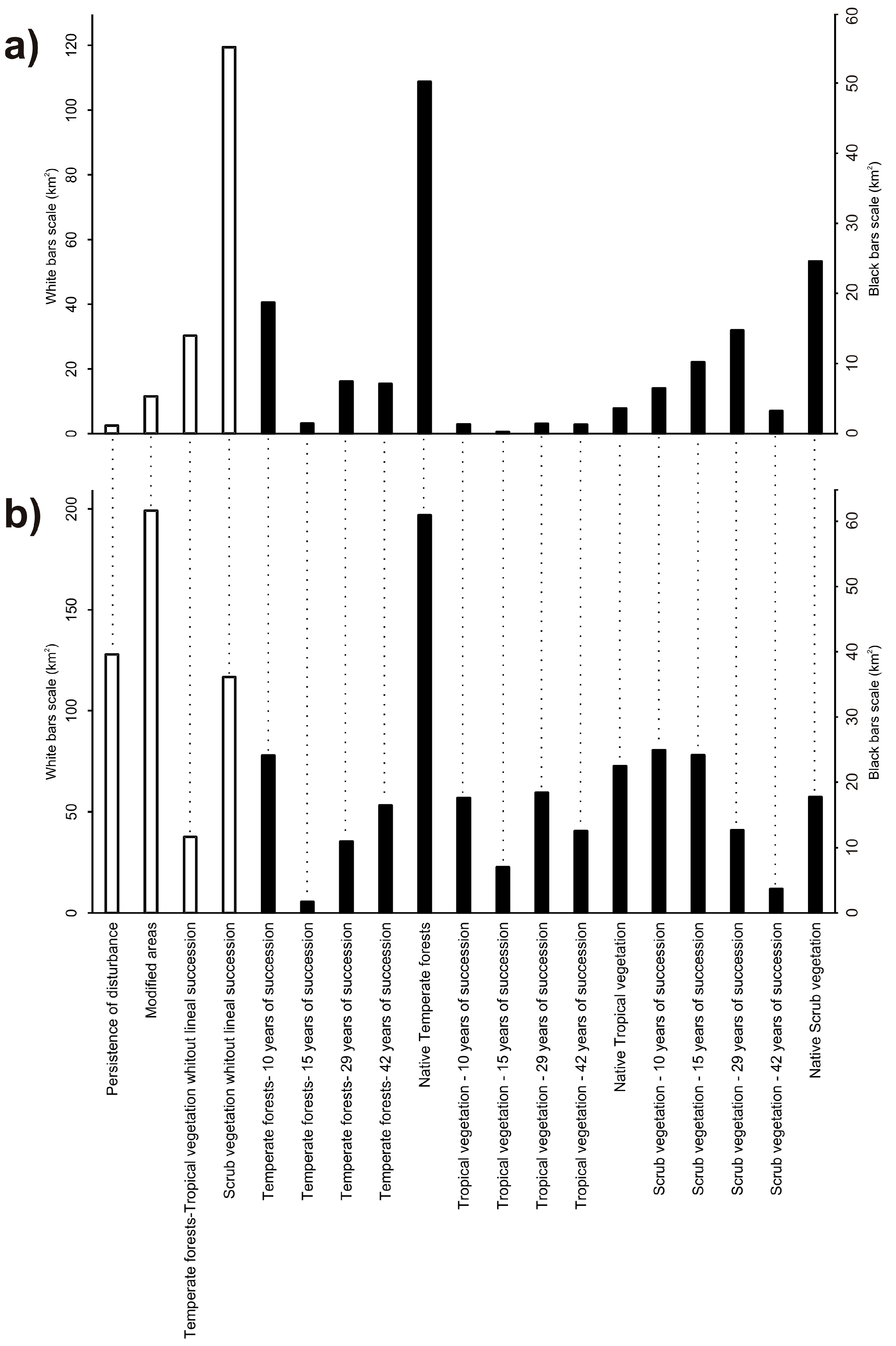
The Scrub vegetation (which includes submontane scrub and Tamaulipan thornscrub, and others) constitutes an endangered category of vegetation, despite being a dominant plant community in northeastern Mexico, as well as on the slopes of the Sierra Madre Oriental within the study area [
59,
83,
84]. This type of vegetation has suffered great losses in Mexico, and at present, many areas of this vegetal cover have some degree of alteration, or are fragmented, distributed in mosaics with different successional stage [
85,
86]. A similar trend was observed in the NPAAC, since the cross-tabulation analysis showed that the Scrub without linear succession is currently the predominant category. It suggests that these areas recovered after disturbances, but experienced new modifications or different successional trajectories between different types of vegetation that culminated with the presence of Scrub vegetation in the most recent scene (year 2015). Also, it indicates that a large extension of the Scrub vegetation within the NPAAC corresponds to secondary vegetation. This is a relevant situation, since the LULCC analysis proved that much of this coverage comes from many modified and disturbed areas of Temperate forests that did not recuperate their original state and were covered in 2015 by Scrub vegetation. Similarly, Tropical vegetation was reduced almost entirely within the NPAAC, at present it is represented by only a few conserved remnants, and some areas with 42 or 29 years of succession, mainly in zones adjacent to rivers, while much of the original vegetation exhibited a transition to Scrub vegetation. This type of transition is a documented phenomenon, since after the disturbance, the scrub vegetation is one of the first stages of succession [
59]. The high modification values observed in the region are similar to the general increase of secondary vegetation cover [
22], since many vegetation types are undergoing high rates of change in other countries [
62]. However, it is also possible that several areas in this category in 2015 represent transition zones, with Scrub vegetation elements mixed with elements of Temperate forests or Tropical vegetation (such as low subcaducifolious forest or low thorn forest). In this sense, it has been recognized that the submontane scrub forms transition zones with the low tropical semideciduous forest towards the lower areas and even with oak forest towards the upper parts of the NPAAC [
44]; this is reflected in a mixture of the vegetation elements. Additionally, the presence of palm trees indicates a dominance of this plant community in other patches of native vegetation of submontane scrub and oak forests as a result of disturbance [
42,
44]. Future analyses may reveal whether these areas categorized as Scrub vegetation are natural ecotones, or represent disturbed areas in a successional process that can be reestablished in the coming years in the absence of new major disturbances.
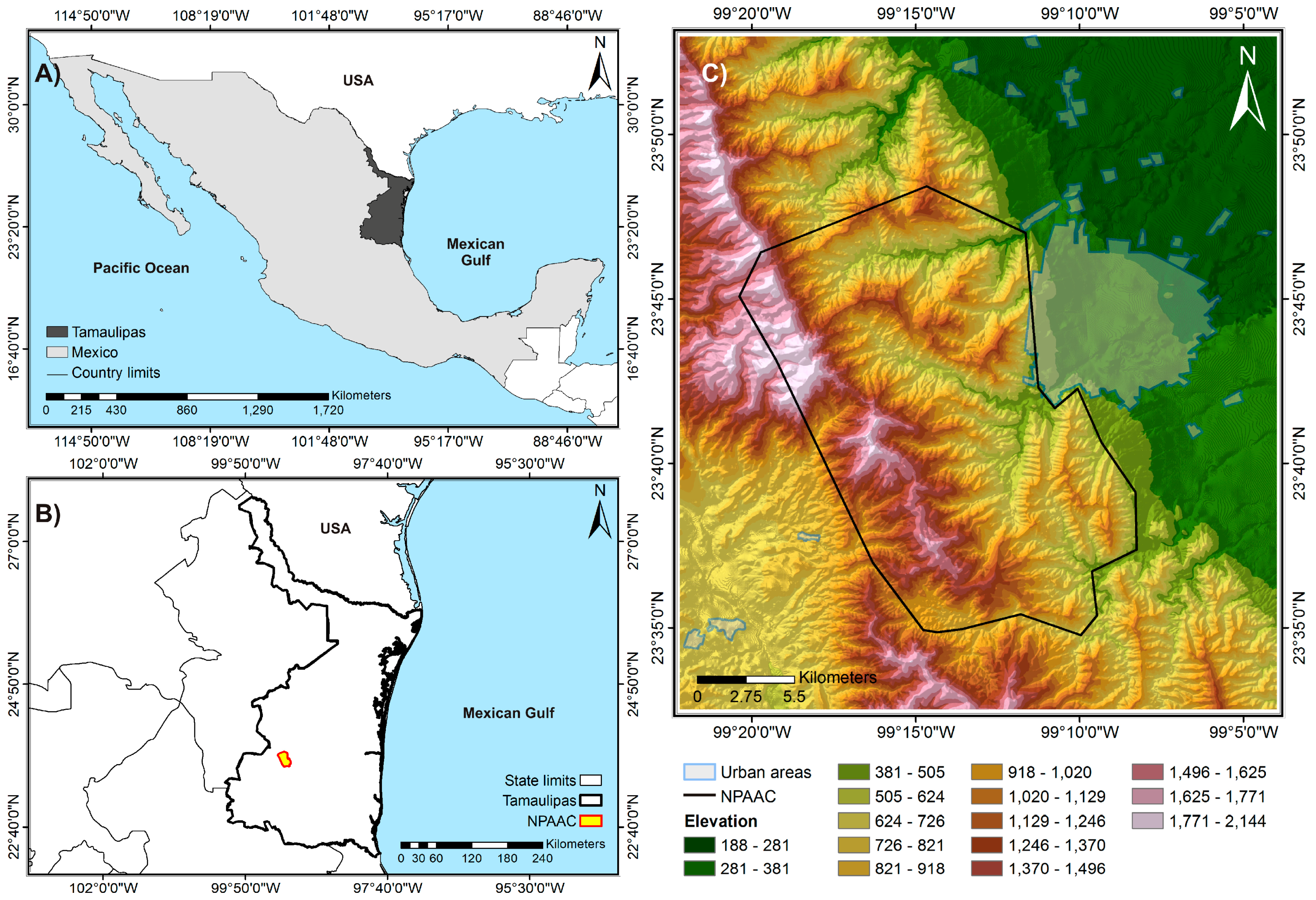
As stated previously, large extensions of Temperate forests in the NPAAC were modified to Scrub vegetation through the evaluated period. In contrast, the remnants of these forests in 2015 are native areas that have remained unchanged since at least 1973, and the small proportion of this type of vegetation in a given successional stage contributes to an increase in species richness, since it has been observed that the presence of temperate plant communities with different succession times favors regeneration and allows for diversity [
77]. Moreover, the spatial distribution of Temperate forests, both native areas and those with a successional process, was mostly concentrated in the northwestern part of the NPAAC, and agrees with the most recent categorization proposed in the official management plan for the study area [
42], where the same region is recommended as an area for preservation and restoration of the oak-pine forest. Conversely, according to the management plan [
42], most of the NPAAC renders a buffer zone, suggesting the occurrence of significant changes in that area during last years, as well as the presence of other types of secondary vegetation.
In the adjacent area to the NPAAC, the processes of disturbance and succession were more evident. In this case, the southwestern region is mainly a semi-arid zone, so the persistence of areas without dense vegetation was expected. However, an important urban area is located eastern of the NPAAC. This explains the large proportion of Modified areas in 2015 with respect to disturbance in 1973, as well as the presence of a greater extension of vegetation in different successional stages. As cited earlier in this study, the importance of adjacent areas for the interior of NPAs is well documented [
11,
36,
63]. This is of major importance when considering the presence of Tropical vegetation by the boundaries between the urban western area and the NPAAC, since the type of vegetation is fragmented and is mostly secondary vegetation with 10, 15, 29 or 42 years of succession, except for some preserved areas towards the north. For Temperate forests, it is evident that the larger proportion is occupied by native vegetation, as this plant community is distributed by the mountains, external to the NPAAC. However, some areas with 10, 29 and 42 years of succession are located around its boundaries, mostly by the western limit, close to the arid areas of the southwestern region. Scrub vegetation depicts important changes, and disturbances have occurred during recent years in the region, as evidenced by the fact that the proportion of native vegetation is lower than that observed for areas with 10 and 15 years of succession, with the vegetation being patches of vegetation distributed around the urban western area, and towards the north and south of the NPAAC. In this study, the categories of Scrub and Tropical vegetation included submontane scrub and low tropical semideciduous forest, which are some of the most important vegetation types and reservoirs of biological diversity [
44]. The implications of these patterns for the NPAAC and its adjacent areas are related to the effects of the time of succession in species and communities. Studies on plants and their associated variables [
7] indicate that the time of succession modifies the structure and composition of the species [
22]. Additionally, areas with recent disturbance show different microclimate conditions, being hotter and drier than late successional areas, where a dense canopy cover favors higher relative humidity and a decline in temperature [
87]. This is a significant implication for succession patterns within the NPAAC and its adjacent areas, as a high proportion of the actual cover of Tropical vegetation and Scrub vegetation represents secondary vegetation of recent succession time, which surely modifies the interactions within these communities. The evidence provided here calls attention to the urgency of assessing and quantifying the effect of succession time on species and biological groups on these vegetation patches, given the importance of the adjacent ecosystem processes towards the interior of the NPAs.
In summary, our results suggest that the study area is made up of a mosaic of patches and fragments of both native areas and secondary vegetation of different successional time, with this being an increasing tendency also in other countries [
8,
22], and a factor of major relevance because the dynamics of secondary forests are related to ecosystem processes [
22]. The high transition rate of Temperate forests and Tropical vegetation to other land cover categories, as well as the constant disturbances in the Scrub vegetation within the NPAAC and its adjacent areas, points out the necessity for a deeper evaluation of the present communities. Since the increasing rates of land use-cover change are one of the main causes for biodiversity loss [
6], it is expected that succession patterns are also evaluated within the framework of these studies. However, although secondary succession is a central issue for the analysis of biological communities related to post-disturbance events, it is not always addressed in studies concerning land use-cover changes, whether these are conducted in NPAs or not [
62,
63]. This is of major importance, because any analysis of land cover transition or persistence implies different processes of recovery or modification in vegetation and, more precisely, time of regeneration, which is more accentuated for multitemporal analysis [
3,
8,
9,
14,
15,
16,
17,
18,
19]. Regardless of the method used to delimit the succession time or the presence of secondary vegetation [
20,
22,
23], we must stress the necessity of the evaluation of succession patterns in future studies of land-use cover changes, as was done in this study.


 and
and 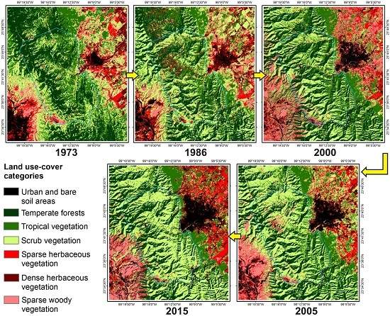


