Improving Fractional Impervious Surface Mapping Performance through Combination of DMSP-OLS and MODIS NDVI Data


Abstract
1. Introduction
2. Study Area and Datasets
3. Methods
3.1. Development of Impervious Surface Area Data from Landsat OLI Images
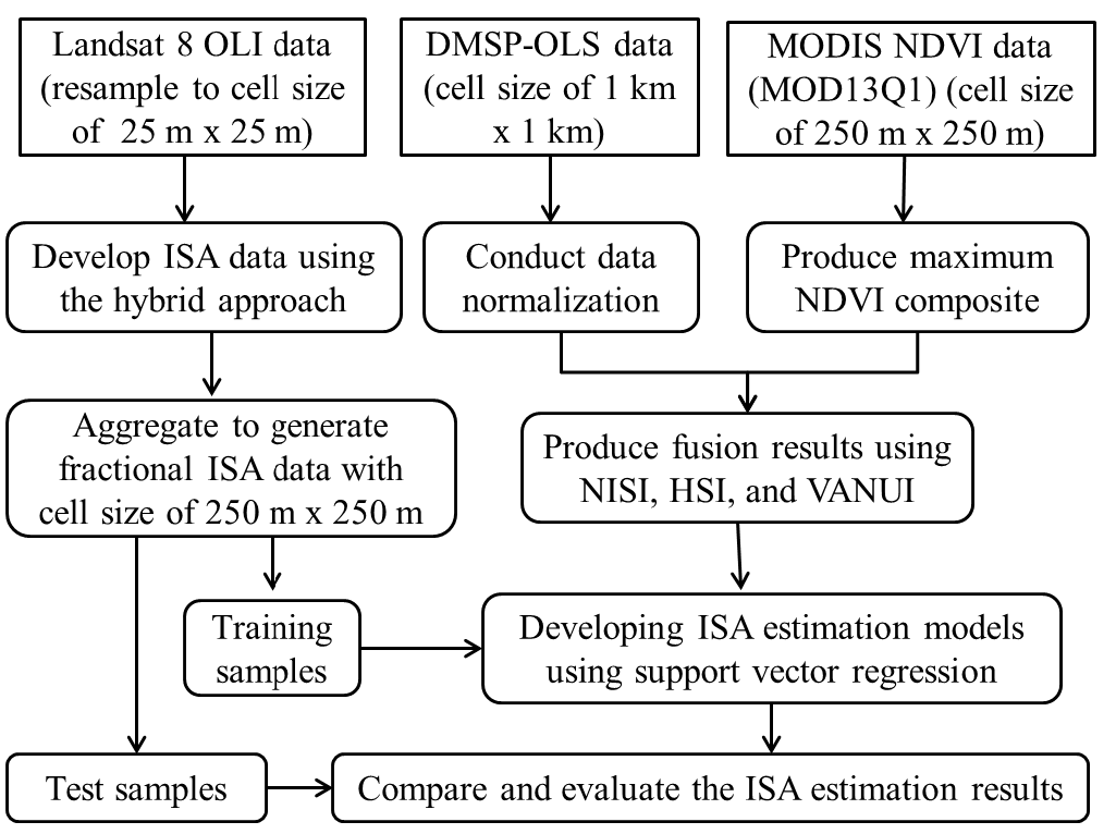
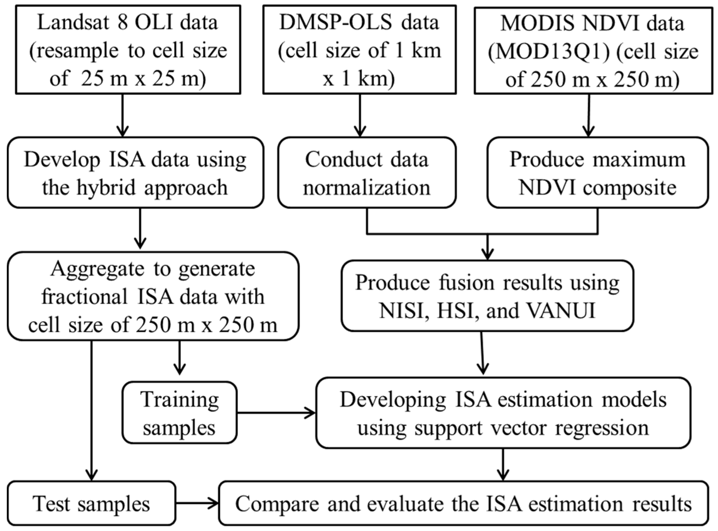
3.2. Preprocessing and Integration of DMSP-OLS and MODIS NDVI Data
3.3. Mapping Fractional Impervious Surface Area Distribution with Support Vector Regression
3.4. Evaluation of the Impervious Surface Area Estimation Results
4. Results
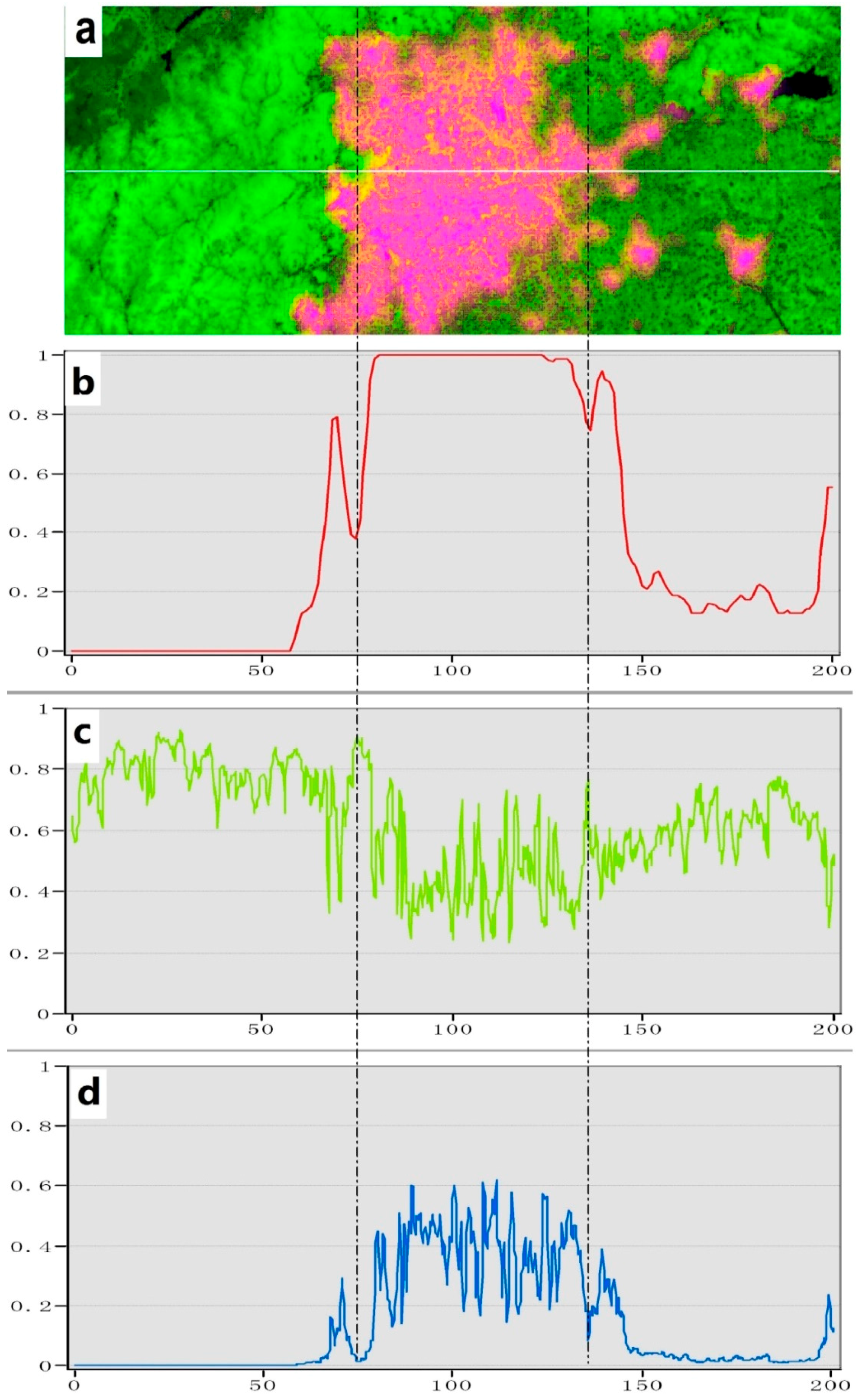
4.1. A Comparative Analysis of the Proposed Index and Individual OLSnor and NDVImax Data
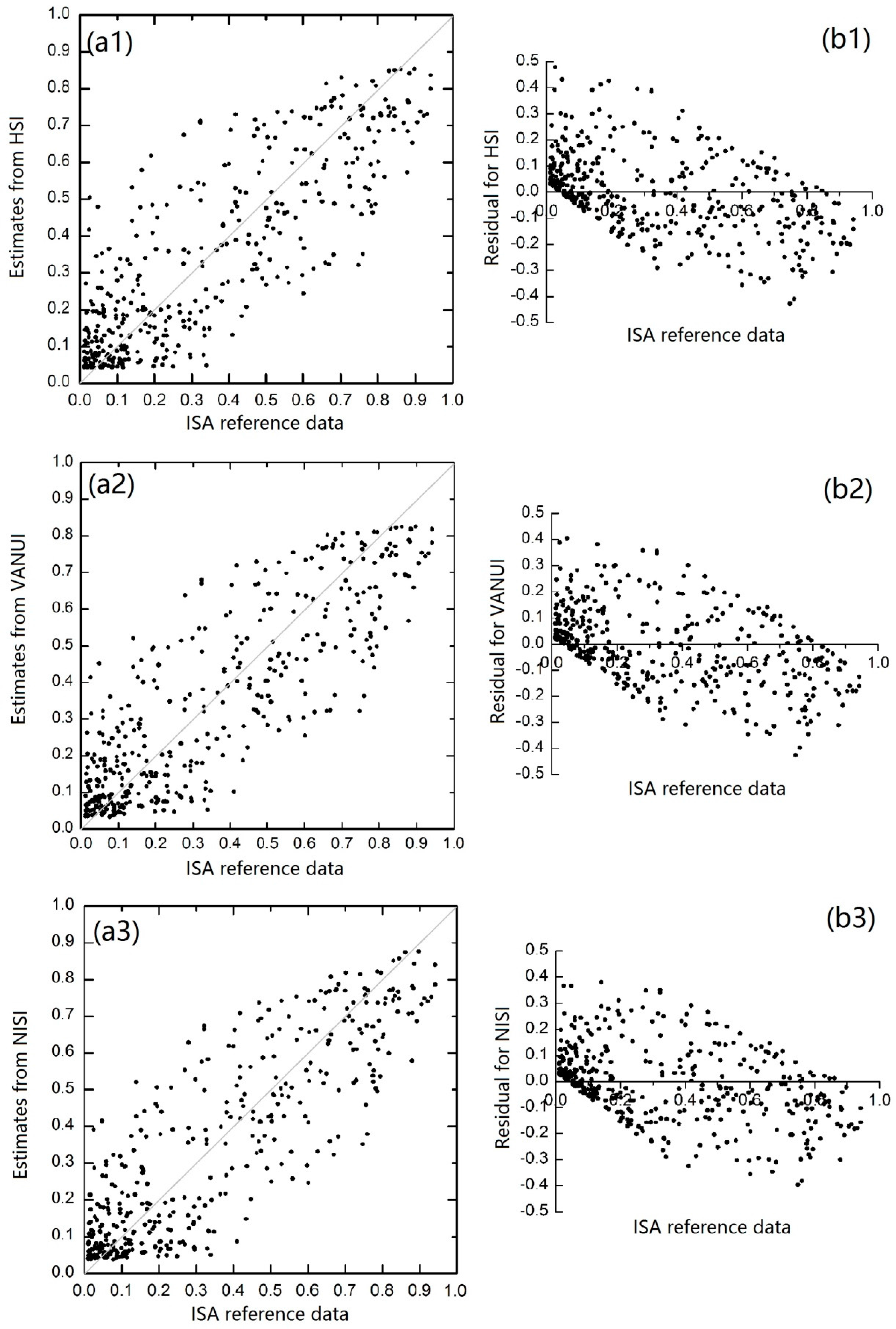
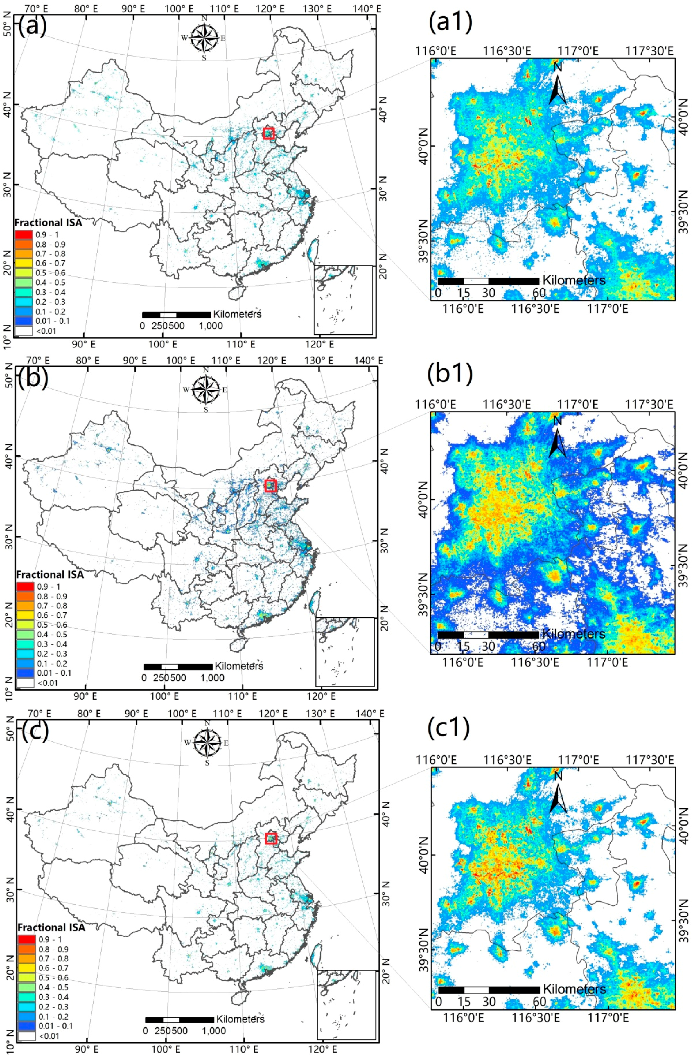
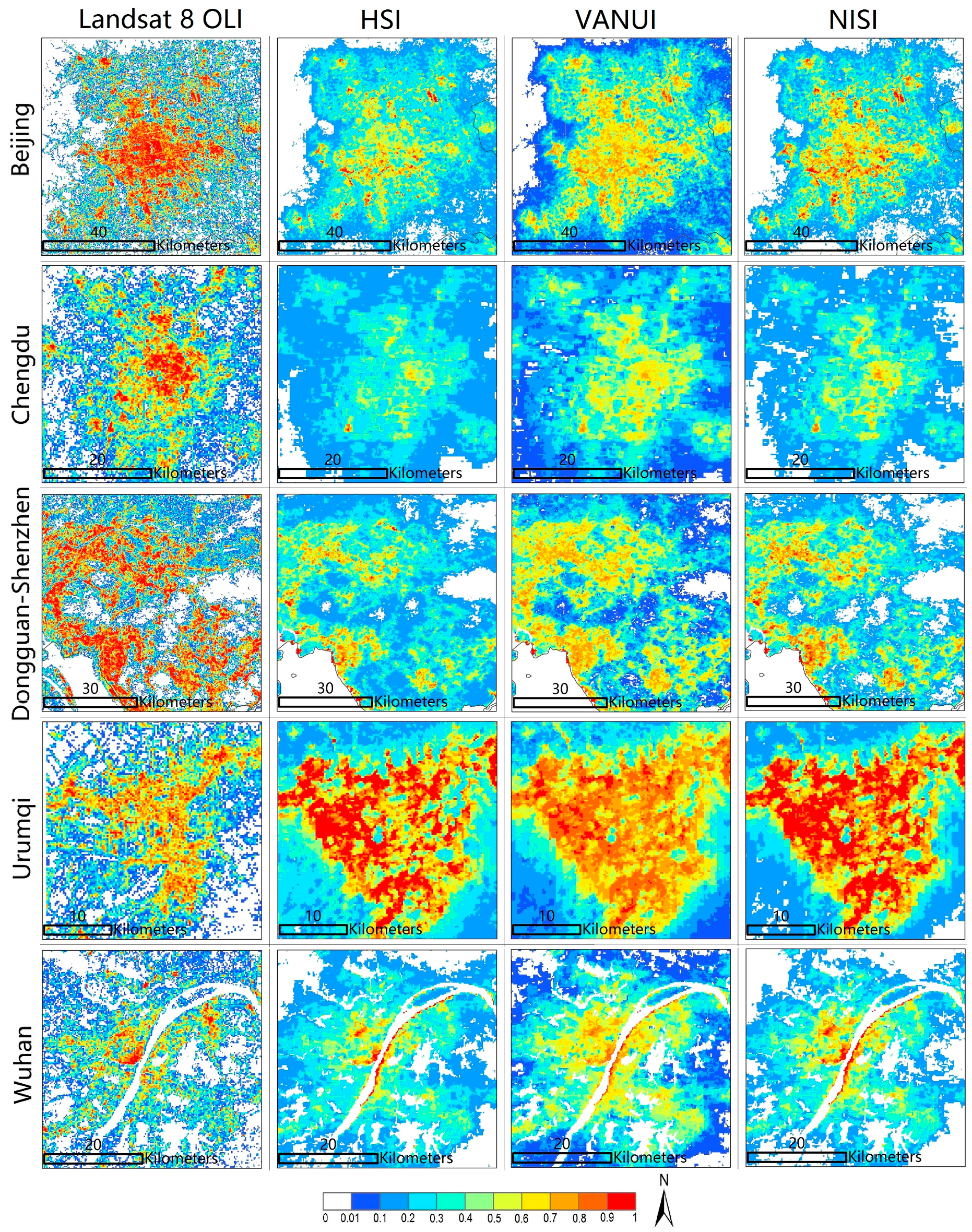
4.2. Analysis of Impervious Surface Area Estimates
5. Discussion
6. Conclusions
Acknowledgments
Author Contributions
Conflicts of Interest
References
- Cao, X.; Wang, J.; Chen, J.; Shi, F. Spatialization of electricity consumption of China using saturation-corrected DMSP-OLS data. Int. J. Appl. Earth Obs. Geoinf. 2014, 28, 193–200. [Google Scholar] [CrossRef] [Scilit]
- Kuang, W.; Liu, J.; Zhang, Z.; Lu, D.; Xiang, B. Spatiotemporal dynamics of impervious surface areas across China during the early 21st century. Chin. Sci. Bull. 2012, 58, 1691–1701. [Google Scholar] [CrossRef] [Scilit]
- Schneider, A.; Chang, C.; Paulsen, K. The changing spatial form of cities in western China. Landsc. Urban Plan. 2015, 135, 40–61. [Google Scholar] [CrossRef] [Scilit]
- China–Population. Available online: http://countryeconomy.com/demography/population/china (accessed on 14 April 2017).
- Urbanization in China. Available online: https://en.wikipedia.org/wiki/Urbanization_in_China (accessed on 14 April 2017).
- Kaufmann, R.K.; Seto, K.C.; Schneider, A.; Liu, Z.; Zhou, L.; Wang, W. Climate response to rapid urban growth: Evidence of a human-induced precipitation deficit. J. Clim. 2007, 20, 2299–2306. [Google Scholar] [CrossRef] [Scilit]
- Ma, T.; Zhou, C.; Pei, T.; Haynie, S.; Fan, J. Quantitative estimation of urbanization dynamics using time series of DMSP/OLS nighttime light data: A comparative case study from China’s cities. Remote Sens. Environ. 2012, 124, 99–107. [Google Scholar] [CrossRef] [Scilit]
- Ma, T.; Zhou, Y.; Zhou, C.; Haynie, S.; Pei, T.; Xu, T. Night-time light derived estimation of spatiotemporal characteristics of urbanization dynamics using DMSP/OLS satellite data. Remote Sens. Environ. 2015, 158, 453–464. [Google Scholar] [CrossRef] [Scilit]
- Srinivasan, V.; Seto, K.C.; Emerson, R.; Gorelick, S.M. The impact of urbanization on water vulnerability: A coupled human–environment system approach for Chennai, India. Glob. Environ. Chang. 2013, 23, 229–239. [Google Scholar] [CrossRef] [Scilit]
- Xu, H.; Lin, D.; Tang, F. The impact of impervious surface development on land surface temperature in a subtropical city: Xiamen, China. Int. J. Climatol. 2013, 33, 1873–1883. [Google Scholar] [CrossRef] [Scilit]
- Yuan, F.; Bauer, M.E. Comparison of impervious surface area and normalized difference vegetation index as indicators of surface urban heat island effects in Landsat imagery. Remote Sens. Environ. 2007, 106, 375–386. [Google Scholar] [CrossRef] [Scilit]
- Kuang, W.; Chi, W.; Lu, D.; Dou, Y. A comparative analysis of megacity expansions in China and the U.S.: Patterns, rates and driving forces. Landsc. Urban Plan. 2014, 132, 121–135. [Google Scholar] [CrossRef] [Scilit]
- Mertes, C.M.; Schneider, A.; Sulla-Menashe, D.; Tatem, A.J.; Tan, B. Detecting change in urban areas at continental scales with MODIS data. Remote Sens. Environ. 2015, 158, 331–347. [Google Scholar] [CrossRef] [Scilit]
- Pandey, B.; Joshi, P.K.; Seto, K.C. Monitoring urbanization dynamics in India using DMSP/OLS night time lights and SPOT-VGT data. Int. J. Appl. Earth Obs. Geoinf. 2013, 23, 49–61. [Google Scholar] [CrossRef] [Scilit]
- Schneider, A. Monitoring land cover change in urban and peri-urban areas using dense time stacks of Landsat satellite data and a data mining approach. Remote Sens. Environ. 2012, 124, 689–704. [Google Scholar] [CrossRef] [Scilit]
- Zhang, Q.; Seto, K.C. Mapping urbanization dynamics at regional and global scales using multi-temporal DMSP/OLS nighttime light data. Remote Sens. Environ. 2011, 115, 2320–2329. [Google Scholar] [CrossRef] [Scilit]
- Zhou, Y.; Smith, S.J.; Zhao, K.; Imhoff, M.; Thomson, A.; Bond-Lamberty, B.; Asrar, G.R.; Zhang, X.; He, C.; Elvidge, C.D. A global map of urban extent from nightlights. Environ. Res. Lett. 2015, 10, 054011. [Google Scholar] [CrossRef] [Scilit]
- Lu, D.; Li, G.; Kuang, W.; Moran, E. Methods to extract impervious surface areas from satellite images. Int. J. Digit. Earth 2013, 7, 93–112. [Google Scholar] [CrossRef] [Scilit]
- Lu, D.; Li, G.; Moran, E.; Batistella, M.; Freitas, C.C. Mapping impervious surfaces with the integrated use of Landsat thematic mapper and radar data: A case study in an urban–rural landscape in the Brazilian Amazon. ISPRS J. Photogramm. Remote Sens. 2011, 66, 798–808. [Google Scholar] [CrossRef] [Scilit]
- Lu, D.; Weng, Q. Use of impervious surface in urban land-use classification. Remote Sens. Environ. 2006, 102, 146–160. [Google Scholar] [CrossRef] [Scilit]
- Weng, Q. Remote sensing of impervious surfaces in the urban areas: Requirements, methods, and trends. Remote Sens. Environ. 2012, 117, 34–49. [Google Scholar] [CrossRef] [Scilit]
- Wu, C.; Murray, A.T. Estimating impervious surface distribution by spectral mixture analysis. Remote Sens. Environ. 2003, 84, 493–505. [Google Scholar] [CrossRef] [Scilit]
- Elvidge, C.; Tuttle, B.; Sutton, P.; Baugh, K.; Howard, A.; Milesi, C.; Bhaduri, B.; Nemani, R. Global distribution and density of constructed impervious surfaces. Sensors 2007, 7, 1962–1979. [Google Scholar] [CrossRef] [Scilit]
- Ma, Q.; He, C.; Wu, J.; Liu, Z.; Zhang, Q.; Sun, Z. Quantifying spatiotemporal patterns of urban impervious surfaces in China: An improved assessment using nighttime light data. Landsc. Urban Plan. 2014, 130, 36–49. [Google Scholar] [CrossRef] [Scilit]
- Yang, Y.; He, C.; Zhang, Q.; Han, L.; Du, S. Timely and accurate national-scale mapping of urban land in China using defense meteorological satellite program’s operational Linescan system nighttime stable light data. APPRES 2013, 7, 073535. [Google Scholar] [CrossRef] [Scilit]
- Imhoff, M.L.; Lawrence, W.T.; Stutzer, D.C.; Elvidge, C.D. A technique for using composite DMSP/OLS “city lights” satellite data to map urban area. Remote Sens. Environ. 1997, 61, 361–370. [Google Scholar] [CrossRef] [Scilit]
- Henderson, M.; Yeh, E.T.; Gong, P.; Elvidge, C.; Baugh, K. Validation of urban boundaries derived from global night-time satellite imagery. Int. J. Remote Sens. 2003, 24, 595–609. [Google Scholar] [CrossRef] [Scilit]
- Lawrence, W.T.; Imhoff, M.L.; Kerle, N.; Stutzer, D. Quantifying urban land use and impact on soils in Egypt using diurnal satellite imagery of the earth surface. Int. J. Remote Sens. 2010, 23, 3921–3937. [Google Scholar] [CrossRef] [Scilit]
- Lu, D.; Tian, H.; Zhou, G.; Ge, H. Regional mapping of human settlements in southeastern china with multisensor remotely sensed data. Remote Sens. Environ. 2008, 112, 3668–3679. [Google Scholar] [CrossRef] [Scilit]
- Elvidge, C.D.; Baugh, K.E.; Dietz, J.B.; Bland, T.; Sutton, P.C.; Kroehl, H.W. Radiance calibration of DMSP-OLS low-light imaging data of human settlements. Remote Sens. Environ. 1999, 68, 77–88. [Google Scholar] [CrossRef] [Scilit]
- Ma, L.; Wu, J.; Li, W.; Peng, J.; Liu, H. Evaluating saturation correction methods for DMSP/OLS nighttime light data: A case study from China’s cities. Remote Sens. 2014, 6, 9853–9872. [Google Scholar] [CrossRef] [Scilit]
- Small, C.; Elvidge, C.D.; Balk, D.; Montgomery, M. Spatial scaling of stable night lights. Remote Sens. Environ. 2011, 115, 269–280. [Google Scholar] [CrossRef] [Scilit]
- Zhang, Q.; Seto, K. Can night-time light data identify typologies of urbanization? A global assessment of successes and failures. Remote Sens. 2013, 5, 3476–3494. [Google Scholar] [CrossRef] [Scilit]
- Deng, C.; Wu, C. The use of single-date MODIS imagery for estimating large-scale urban impervious surface fraction with spectral mixture analysis and machine learning techniques. ISPRS J. Photogramm. Remote Sens. 2013, 86, 100–110. [Google Scholar] [CrossRef] [Scilit]
- Knight, J.; Voth, M. Mapping impervious cover using multi-temporal MODIS NDVI data. IEEE J. Sel. Top. Appl. Earth Obs. Remote Sens. 2011, 4, 303–309. [Google Scholar] [CrossRef] [Scilit]
- Schneider, A.; Friedl, M.A.; Potere, D. A new map of global urban extent from MODIS satellite data. Environ. Res. Lett. 2009, 4, 044003. [Google Scholar] [CrossRef] [Scilit]
- Schneider, A.; Friedl, M.A.; Potere, D. Mapping global urban areas using MODIS 500-m data: New methods and datasets based on ‘urban ecoregions’. Remote Sens. Environ. 2010, 114, 1733–1746. [Google Scholar] [CrossRef] [Scilit]
- Yang, F.; Matsushita, B.; Fukushima, T.; Yang, W. Temporal mixture analysis for estimating impervious surface area from multi-temporal MODIS NDVI data in Japan. ISPRS J. Photogramm. Remote Sens. 2012, 72, 90–98. [Google Scholar] [CrossRef] [Scilit]
- Shao, Z.; Liu, C. The integrated use of DMSP/OLS nighttime light and MODIS data for monitoring large-scale impervious surface dynamics: A case study in the Yangtze River delta. Remote Sens. 2014, 6, 9359–9378. [Google Scholar] [CrossRef] [Scilit]
- Zhang, Q.; Schaaf, C.; Seto, K.C. The vegetation adjusted NTL urban index: A new approach to reduce saturation and increase variation in nighttime luminosity. Remote Sens. Environ. 2013, 129, 32–41. [Google Scholar] [CrossRef] [Scilit]
- Zhuo, L.; Zheng, J.; Zhang, X.; Li, J.; Liu, L. An improved method of night-time light saturation reduction based on EVI. Int. J. Remote Sens. 2015, 36, 4114–4130. [Google Scholar] [CrossRef] [Scilit]
- Cao, X.; Chen, J.; Imura, H.; Higashi, O. A SVM-based method to extract urban areas from DMSP-OLS and SPOT VGT data. Remote Sens. Environ. 2009, 113, 2205–2209. [Google Scholar] [CrossRef] [Scilit]
- Kuang, W. Evaluating impervious surface growth and its impacts on water environment in Beijing-Tianjin-Tangshan metropolitan area. J. Geogr. Sci. 2012, 22, 535–547. [Google Scholar] [CrossRef] [Scilit]
- Guo, W.; Lu, D.; Wu, Y.; Zhang, J. Mapping impervious surface distribution with integration of SNNP VIIRS DNB and MODIS NDVI data. Remote Sens. 2015, 7, 12459–12477. [Google Scholar] [CrossRef] [Scilit]
- Liu, J.; Zhang, Q.; Hu, Y. Regional differences of China’s urban expansion from late 20th to early 21st century based on remote sensing information. Chin. Geogr. Sci. 2012, 22, 1–14. [Google Scholar] [CrossRef] [Scilit]
- Schneider, A.; Mertes, C.M.; Tatem, A.J.; Tan, B.; Sulla-Menashe, D.; Graves, S.J.; Patel, N.N.; Horton, J.A.; Gaughan, A.E.; Rollo, J.T.; et al. A new urban landscape in east–southeast Asia, 2000–2010. Environ. Res. Lett. 2015, 10, 034002. [Google Scholar] [CrossRef] [Scilit]
- Sutton, P.C.; Elvidge, C.D.; Baugh, K.; Ziskin, D. Mapping the constructed surface area density for China. Proc. Asia-Pac. Adv. Netw. 2011, 31, 69. [Google Scholar] [CrossRef] [Scilit]
- Elvidge, C.D.; Imhoff, M.L.; Baugh, K.E.; Hobson, V.R.; Nelson, I.; Safran, J.; Dietz, J.B.; Tuttle, B.T. Night-time lights of the world: 1994–1995. ISPRS J. Photogramm. Remote Sens. 2001, 56, 81–99. [Google Scholar] [CrossRef] [Scilit]
- Carroll, M.L.; Townshend, J.R.; DiMiceli, C.M.; Noojipady, P.; Sohlberg, R.A. A new global raster water mask at 250 m resolution. Int. J. Digit. Earth 2009, 2, 291–308. [Google Scholar] [CrossRef] [Scilit]
- Brenning, A. Benchmarking classifiers to optimally integrate terrain analysis and multispectral remote sensing in automatic rock glacier detection. Remote Sens. Environ. 2009, 113, 239–247. [Google Scholar] [CrossRef] [Scilit]
- Mountrakis, G.; Im, J.; Ogole, C. Support vector machines in remote sensing: A review. ISPRS J. Photogramm. Remote Sens. 2011, 66, 247–259. [Google Scholar] [CrossRef] [Scilit]
- Congalton, R.G. A review of assessing the accuracy of classifications of remotely sensed data. Remote Sens. Environ. 1991, 37, 35–46. [Google Scholar] [CrossRef] [Scilit]
- McRoberts, R.E.; Næsset, E.; Gobakken, T. Inference for lidar-assisted estimation of forest growing stock volume. Remote Sens. Environ. 2013, 128, 268–275. [Google Scholar] [CrossRef] [Scilit]
- Elvidge, C.D.; Cinzano, P.; Pettit, D.R.; Arvesen, J.; Sutton, P.; Small, C.; Nemani, R.; Longcore, T.; Rich, C.; Safran, J.; et al. The Nightsat mission concept. Int. J. Remote Sens. 2007, 28, 2645–2670. [Google Scholar] [CrossRef] [Scilit]
- Zhang, Q.; Li, B.; Thau, D.; Moore, R. Building a better urban picture: Combining day and night remote sensing imagery. Remote Sens. 2015, 7, 11887–11913. [Google Scholar] [CrossRef] [Scilit]
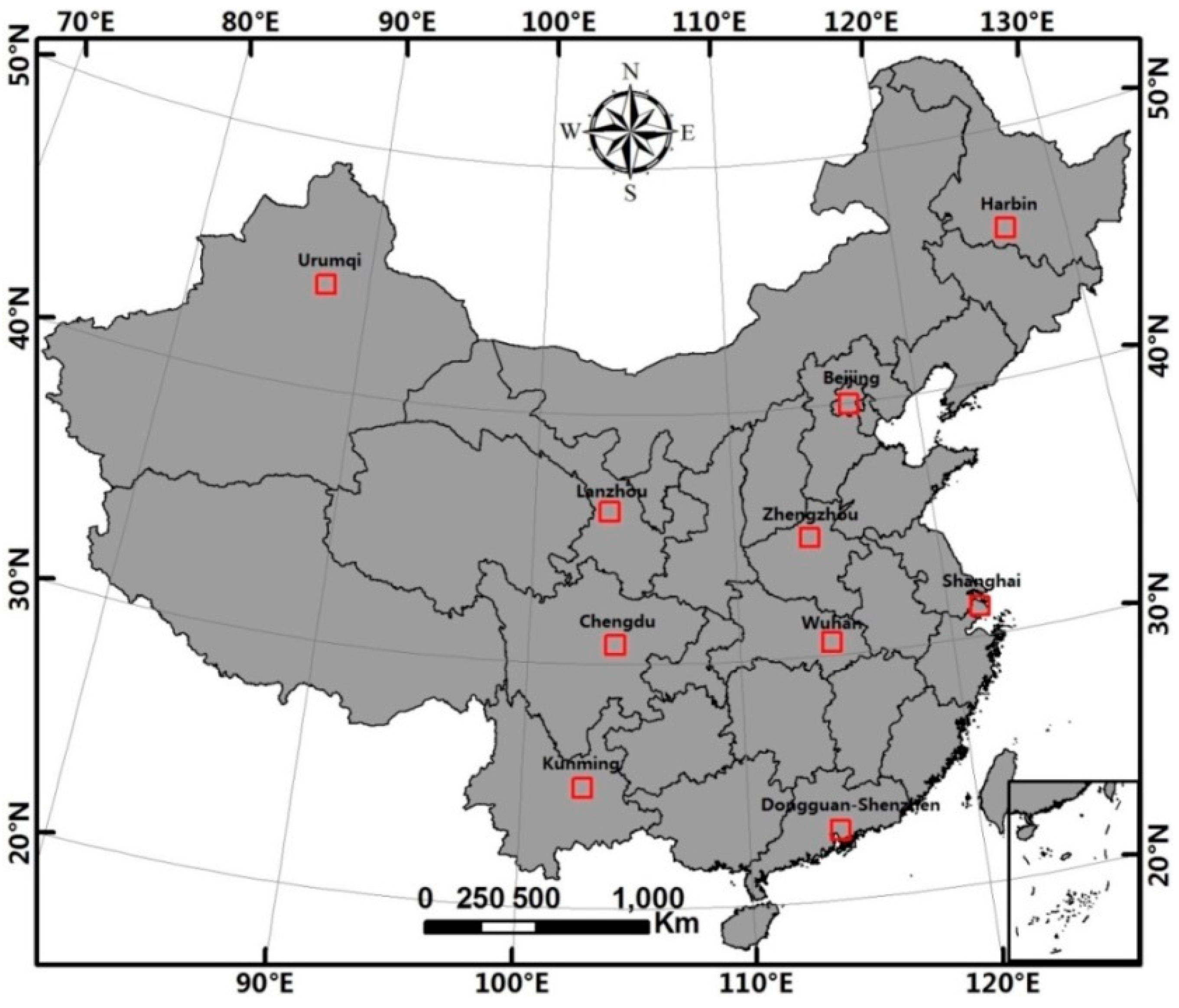



| Cities | Population (Million) | Gross Domestic Product (Billion RMB) | Administrative Area (km2) |
|---|---|---|---|
| Beijing in North China | 20.69 | 1780 | 16,800 |
| Chengdu in Central China | 11.73 | 814 | 12,390 |
| Dongguan-Shenzhen in Southeast China | 18.84 | 1796 | 4462 |
| Urumqi in Northwest China | 3.35 | 206 | 15,173 |
| Wuhan in Central China | 10.12 | 800 | 8494 |
| Harbin in Northeast China | 9.95 | 455 | 53,840 |
| Kunming in Southwest China | 6.53 | 301 | 21,001 |
| Shanghai in East China | 23.80 | 2010 | 6340 |
| Lanzhou in Northwest China | 3.61 | 156 | 13,085 |
| Zhengzhou in Central China | 8.63 | 555 | 7446 |
| Data | Acquisition Date | Description | Source |
|---|---|---|---|
| DMSP-OLS | 2012 | Version 4 with data range of 6 bits (0–63) and 30 arc-seconds under WGS84 spatial reference system | National Geophysical Data Center (http://ngdc.noaa.gov/eog/dmsp/downloadV4composites.html) |
| MODIS NDVI (MOD13Q1) | April–October 2012. 247 scenes, including: h23v04–h23v05, h24v04–h24v05, h25v03–h25v06, h26v03–h26v06, h27v04–h27v06, h28v05–h28v07, h29v06 | Gridded level-3 product, a 16-day composite MODIS NDVI product with 250-m spatial resolution and 12-bit data range | NASA Goddard Space Flight Center (http://ladsweb.nascom.nasa.gov/data/search.hOLIl) |
| MOD44W | A global water-masked map which was released in 2009 | A global map of surface water at 250-m spatial resolution was produced using the combination of SRTM Water Body Data and MODIS data | Global Land Cover Facility (http://glcf.umd.edu/data/watermask/) |
| Landsat 8 OLI imagery | Path/Row: Acquisition date 123/32: 2013-09-01 129/39: 2013-04-20 122/44: 2013-11-29 118/28: 2013-07-12 129/43: 2013-04-20 130/35: 2013-08-01 118/38: 2013-08-29 123/39: 2013-05-12 143/29: 2013-08-28 124/36: 2013-06-04 | The Landsat 8 OLI imagery covers 11 bands: seven reflective bands (e.g., visible, near infrared, and shortwave infrared) with 30-m, one panchromatic band (band 8) with 15-m, and two thermal infrared bands (bands 10 and 11) with 100-m spatial resolution. | United States Geological Survey (http://earthexplorer.usgs.gov/) |
| Index | Correlation Coefficient (R) | Root Mean Squared Error (RMSE) | Relative RMSE (RMSEr) |
|---|---|---|---|
| HSI | 0.83 | 0.154 | 44.3 |
| VANUI | 0.85 | 0.149 | 42.9 |
| NISI | 0.86 | 0.145 | 41.8 |
| ISA Ranges | Samples | HSI | Diff(H-M) | VANUI | Diff(V-M) | NISI | Diff(N-M) |
|---|---|---|---|---|---|---|---|
| ISA < 0.4 | 0.144 | 0.187 | 0.043 | 0.176 | 0.032 | 0.174 | 0.030 |
| ISA in 0.4–0.8 | 0.603 | 0.540 | −0.063 | 0.537 | −0.066 | 0.554 | −0.049 |
| ISA > 0.8 | 0.863 | 0.737 | −0.126 | 0.738 | −0.125 | 0.751 | −0.112 |
| Overall | 0.348 | 0.343 | −0.005 | 0.337 | −0.011 | 0.341 | −0.007 |
| ISA Ranges | HSI | VANUI | NISI | |||
|---|---|---|---|---|---|---|
| RMSE | RMSEr | RMSE | RMSEr | RMSE | RMSEr | |
| <0.2 | 0.136 | 162.8 | 0.122 | 146.5 | 0.117 | 139.6 |
| 0.2–0.4 | 0.163 | 56.7 | 0.163 | 56.6 | 0.171 | 59.4 |
| 0.4–0.6 | 0.159 | 32.3 | 0.156 | 31.6 | 0.159 | 32.2 |
| 0.6–0.8 | 0.182 | 25.8 | 0.186 | 26.4 | 0.170 | 24.1 |
| ≥0.8 | 0.148 | 17.1 | 0.146 | 16.8 | 0.135 | 15.6 |
© 2017 by the authors. Licensee MDPI, Basel, Switzerland. This article is an open access article distributed under the terms and conditions of the Creative Commons Attribution (CC BY) license (http://creativecommons.org/licenses/by/4.0/).
Share and Cite
Guo, W.; Lu, D.; Kuang, W. Improving Fractional Impervious Surface Mapping Performance through Combination of DMSP-OLS and MODIS NDVI Data. Remote Sens. 2017, 9, 375. https://doi.org/10.3390/rs9040375
Guo W, Lu D, Kuang W. Improving Fractional Impervious Surface Mapping Performance through Combination of DMSP-OLS and MODIS NDVI Data. Remote Sensing. 2017; 9(4):375. https://doi.org/10.3390/rs9040375
Chicago/Turabian StyleGuo, Wei, Dengsheng Lu, and Wenhui Kuang. 2017. "Improving Fractional Impervious Surface Mapping Performance through Combination of DMSP-OLS and MODIS NDVI Data" Remote Sensing 9, no. 4: 375. https://doi.org/10.3390/rs9040375
APA StyleGuo, W., Lu, D., & Kuang, W. (2017). Improving Fractional Impervious Surface Mapping Performance through Combination of DMSP-OLS and MODIS NDVI Data. Remote Sensing, 9(4), 375. https://doi.org/10.3390/rs9040375