
Evaluating the Potential of PROBA-V Satellite Image Time Series for Improving LC Classification in Semi-Arid African Landscapes

 , ,
, ,
Abstract
:
1. Introduction
2. Materials and Methods
2.1. Satellite Data
2.2. Training and Reference Data
- The TREES-3 dataset, prepared by the Joint Research Center (JRC) of the European Commission as continuation of a record carried out in coordination with the United Nations Food and Agricultural Organization for their Global Forest Resource Assessment 2010 [13].
2.3. Temporal Cloud Filter
2.4. Time Series Metrics
2.5. Classifier
2.6. Implementation
3. Results
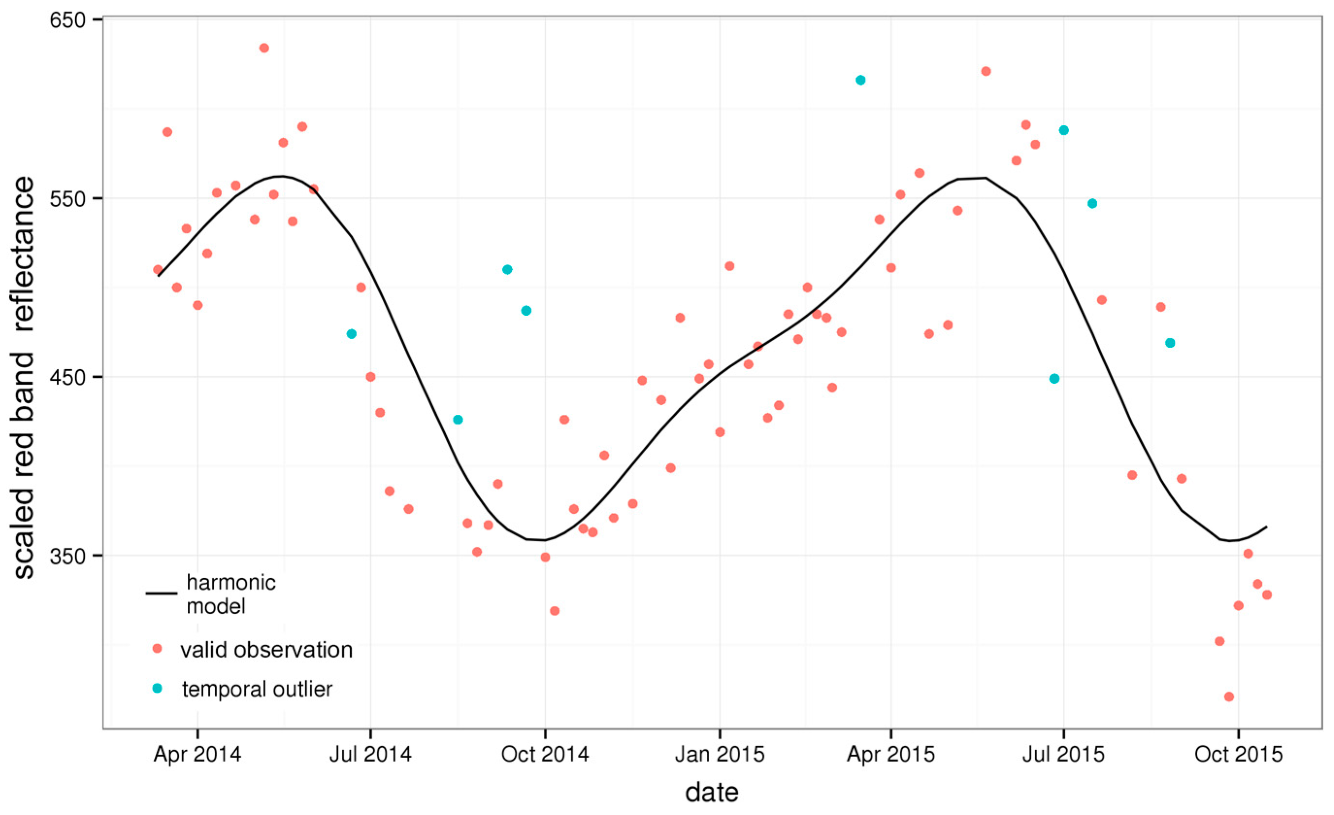
3.1. Temporal Cloud Filter and Metrics
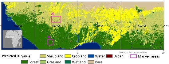
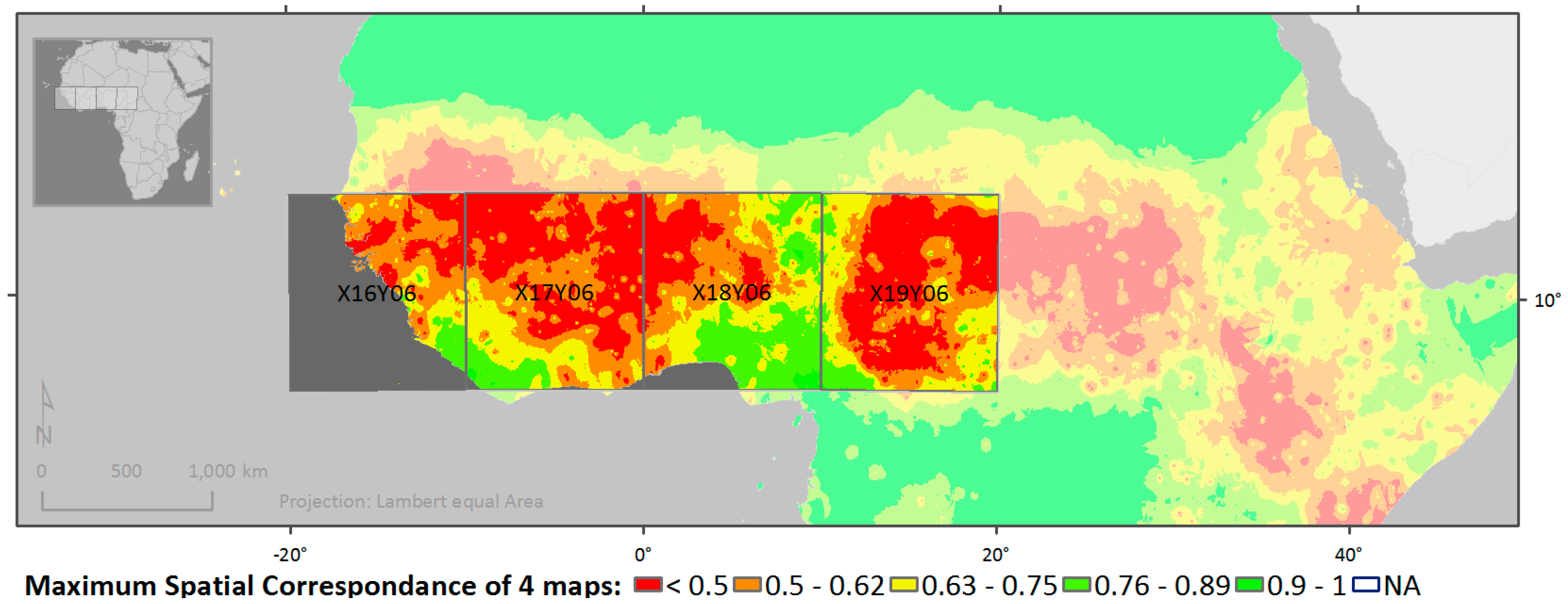
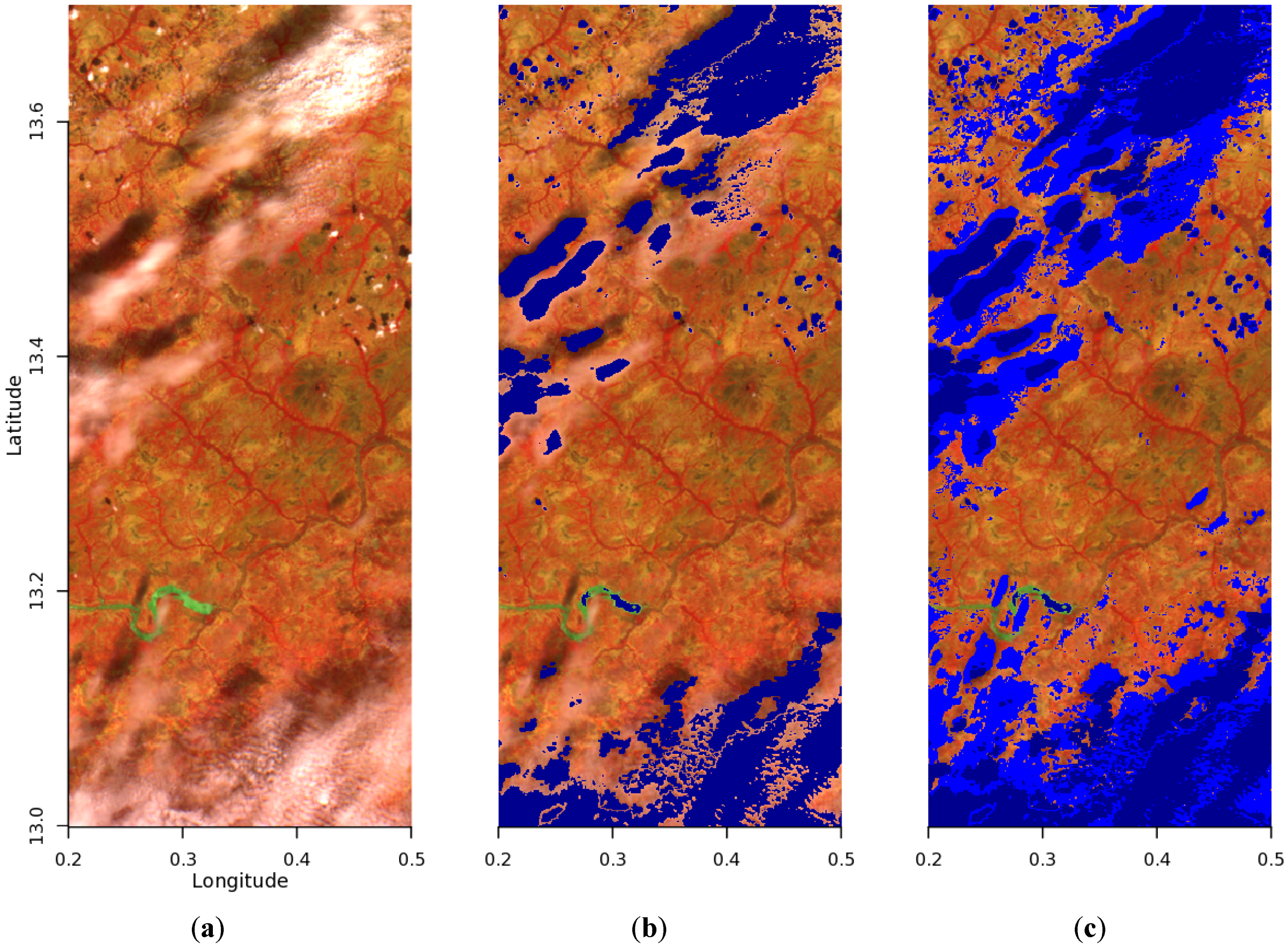
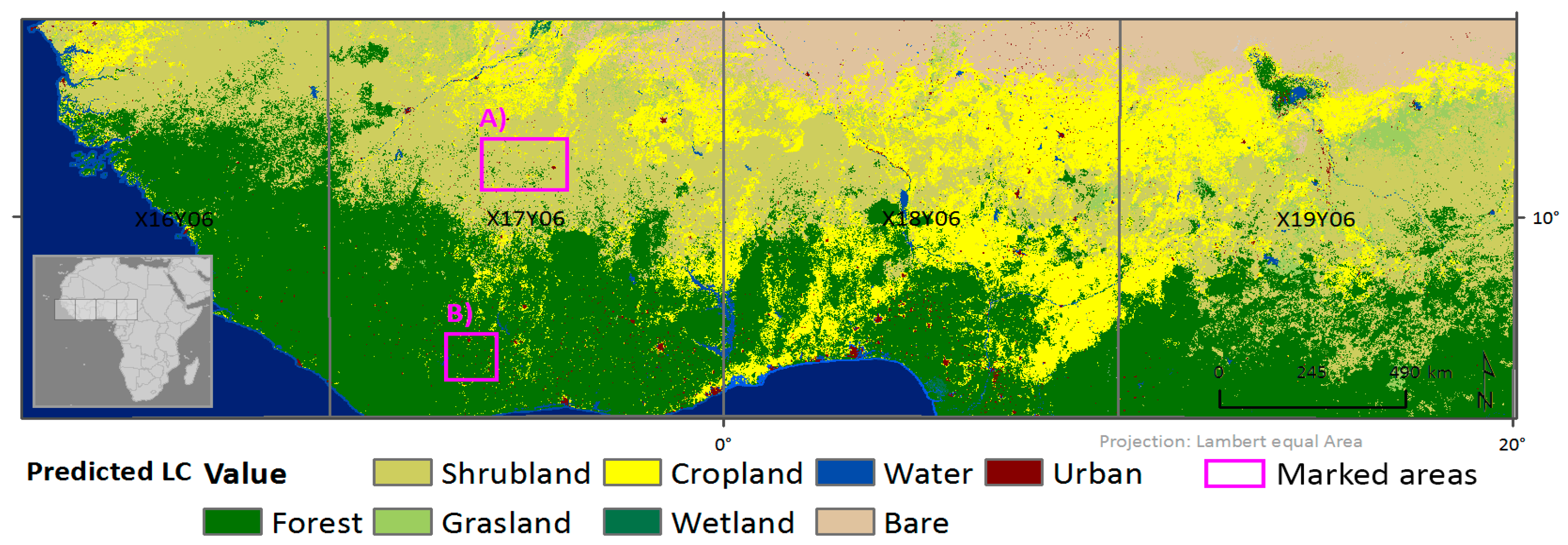
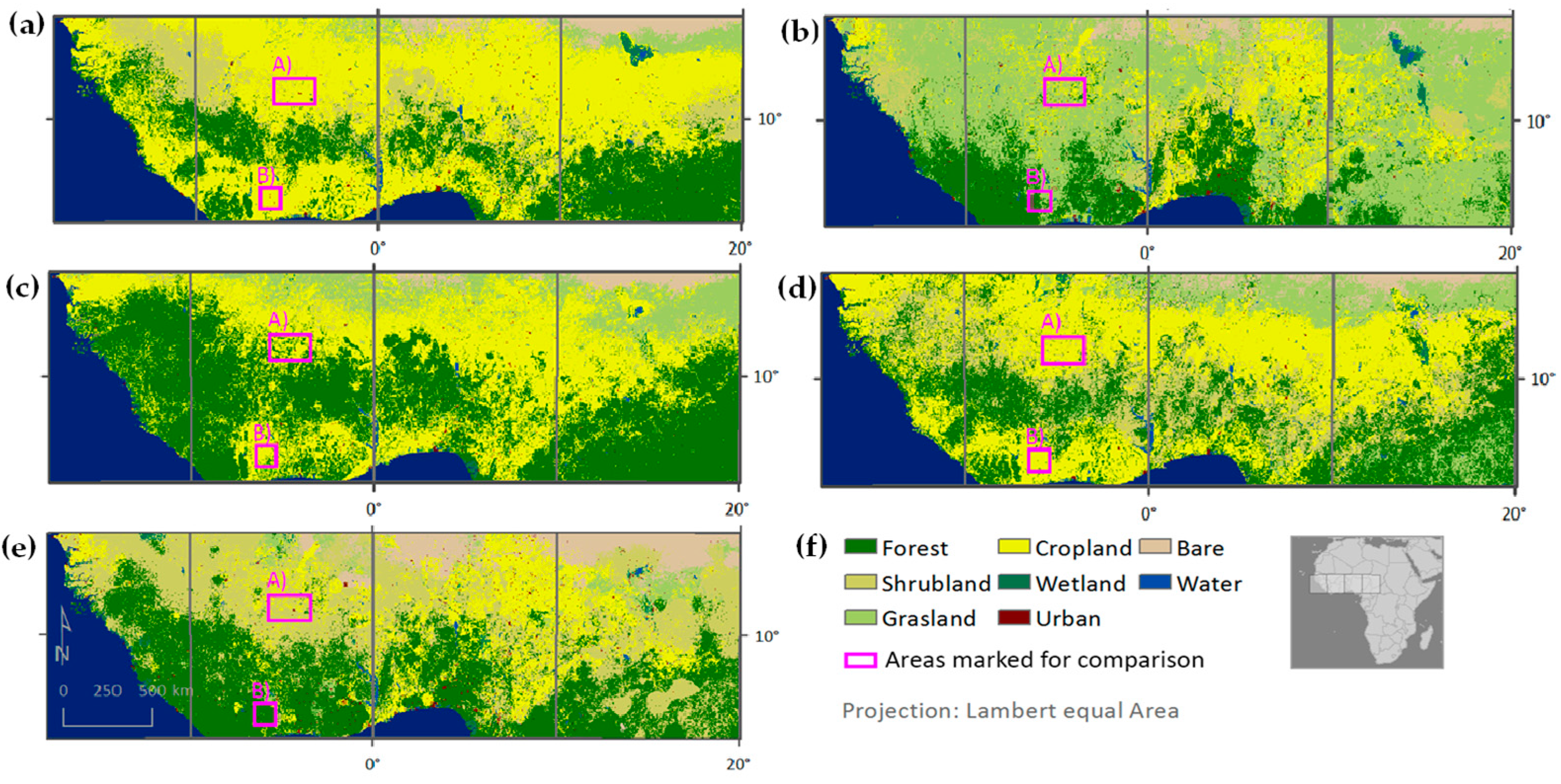
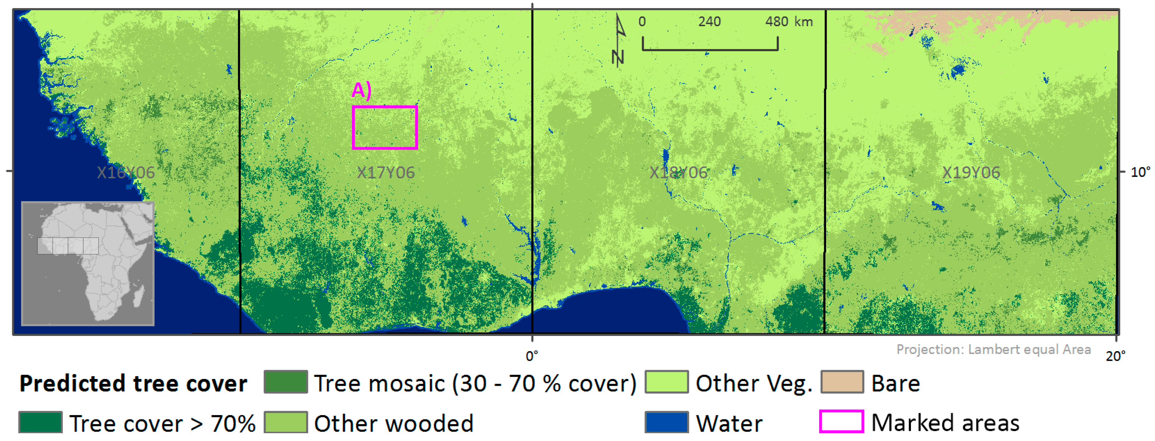
3.2. Use Cases
4. Discussion and Conclusions
Acknowledgments
Author Contributions
Conflicts of Interest
Abbreviations
| FC | Forest cover |
| GOFC-GOLD | Global Observation for Forest Cover and Land Dynamics |
| JRC | Joint Research Centre |
| LC | Land cover |
| LOESS | Locally weighted scatterplot smoothing |
| MODIS | Moderate Resolution Imaging Spectroradiometer |
| NDVI | Normalized difference vegetation index |
| NIR | Near infrared |
| OOB | Out of bag |
| RF | Random Forest |
| RS | Remote sensing |
| SM | State mask |
| SWIR | Short wave infrared |
| TREES | Tropical Ecosystem Environment Observation System |
Appendix A

| Band | Lower Threshold | Upper Threshold | LOESS Span |
|---|---|---|---|
| Blue | −80 | - | 0.3 |
| SWIR | −120 | 120 | 0.3 |
References
- Hüttich, C.; Herold, M.; Wegmann, M.; Cord, A.; Strohbach, B.; Schmullius, C.; Dech, S. Assessing effects of temporal compositing and varying observation periods for large-area land-cover mapping in semi-arid ecosystems: Implications for global monitoring. Remote Sens. Environ. 2011, 115, 2445–2459. [Google Scholar] [CrossRef]
- Sankaran, M.; Hanan, N.P.; Scholes, R.J.; Ratnam, J.; Augustine, D.J.; Cade, B.S.; Gignoux, J.; Higgins, S.I.; Le Roux, X.; Ludwig, F. Determinants of woody cover in African savannas. Nature 2005, 438, 846–849. [Google Scholar] [CrossRef] [PubMed]
- Herold, M.; Mayaux, P.; Woodcock, C.; Baccini, A.; Schmullius, C. Some challenges in global land cover mapping: An assessment of agreement and accuracy in existing 1 km datasets. Remote Sens. Environ. 2008, 112, 2538–2556. [Google Scholar] [CrossRef]
- Jung, M.; Henkel, K.; Herold, M.; Churkina, G. Exploiting synergies of global land cover products for carbon cycle modeling. Remote Sens. Environ. 2006, 101, 534–553. [Google Scholar] [CrossRef]
- Tsendbazar, N.-E.; de Bruin, S.; Fritz, S.; Herold, M. Spatial accuracy assessment and integration of global land cover datasets. Remote Sens. 2015, 7, 15804–15821. [Google Scholar] [CrossRef]
- Zhu, Z.; Woodcock, C.E. Automated cloud, cloud shadow, and snow detection in multitemporal Landsat data: An algorithm designed specifically for monitoring land cover change. Remote Sens. Environ. 2014, 152, 217–234. [Google Scholar] [CrossRef]
- Goodwin, N.R.; Collett, L.J.; Denham, R.J.; Flood, N.; Tindall, D. Cloud and cloud shadow screening across Queensland, Australia: An automated method for Landsat TM/ETM+ time series. Remote Sens. Environ. 2013, 134, 50–65. [Google Scholar] [CrossRef]
- Herold, M. An Assessment of National Forest Monitoring Capabilities in Tropical Non-Annex I Countries: Recommendations for Capacity Building; GOFC-GOLD Land Cover Project Office: Wageningen, The Netherlands; Friedrich Schiller University Jena: Jena, Germany, 2009. [Google Scholar]
- Hansen, M.C.; Potapov, P.V.; Moore, R.; Hancher, M.; Turubanova, S.; Tyukavina, A.; Thau, D.; Stehman, S.; Goetz, S.; Loveland, T. High-resolution global maps of 21st-century forest cover change. Science 2013, 342, 850–853. [Google Scholar] [CrossRef] [PubMed]
- Dierckx, W.; Sterckx, S.; Benhadj, I.; Livens, S.; Duhoux, G.; Van Achteren, T.; Francois, M.; Mellab, K.; Saint, G. PROBA-V mission for global vegetation monitoring: Standard products and image quality. Int. J. Remote Sens. 2014, 35, 2589–2614. [Google Scholar] [CrossRef]
- Lambert, M.-J.; Waldner, F.; Defourny, P. Cropland mapping over sahelian and sudanian agrosystems: A knowledge-based approach using PROBA-V time series at 100-m. Remote Sens. 2016, 8, 232. [Google Scholar] [CrossRef]
- Roumenina, E.; Atzberger, C.; Vassilev, V.; Dimitrov, P.; Kamenova, I.; Banov, M.; Filchev, L.; Jelev, G. Single-and multi-date crop identification using PROBA-V 100 and 300 m S1 products on Zlatia test site, Bulgaria. Remote Sens. 2015, 7, 13843–13862. [Google Scholar] [CrossRef]
- Bodart, C.; Brink, A.B.; Donnay, F.; Lupi, A.; Mayaux, P.; Achard, F. Continental estimates of forest cover and forest cover changes in the dry ecosystems of Africa between 1990 and 2000. J. Biogeogr. 2013, 40, 1036–1047. [Google Scholar] [CrossRef] [PubMed]
- Marchetti, P.; Rivolta, G.; D’Elia, S.; Farres, J.; Gobron, N.; Mason, G. A model for the scientific exploitation of Earth Observation missions: The ESA research and service support. In IEEE Geoscience and Remote Sensing Society Newsletter; No. 162; IEEE: New York, NY, USA, 2012; pp. 10–18. [Google Scholar]
- Wolters, E.; Swinnen, E.; Dierckx, W. Improved PROBA-V cloud detection using globalbedo surface albedo data 2016. In Proceedings of the PROBA-V Symposium, Gent, Belgium, 26–28 January 2016.
- VITO. Product Distribution Portal. Available online: http://www.vito-eodata.be (accessed on 5 March 2015).
- GOFC-GOLD. GOFC-Gold Reference Data Portal. Available online: https://bm-wageningen.cartodb.com/viz/efcf03a8-15de-11e5-86c4-0e4fddd5de28/embed_map (accessed on 1 October 2015).
- Fritz, S.; McCallum, I.; Schill, C.; Perger, C.; See, L.; Schepaschenko, D.; Van der Velde, M.; Kraxner, F.; Obersteiner, M. Geo-Wiki: An online platform for improving global land cover. Environ. Model. Softw. 2012, 31, 110–123. [Google Scholar] [CrossRef]
- Tsendbazar, N.-E.; de Bruin, S.; Herold, M. Integrating global land cover datasets for deriving user-specific maps. Int. J. Digit. Earth 2016, in press. [Google Scholar] [CrossRef]
- Abade, N.A.; Júnior, O.A.d.C.; Guimarães, R.F.; de Oliveira, S.N. Comparative analysis of MODIS time-series classification using support vector machines and methods based upon distance and similarity measures in the Brazilian Cerrado-Caatinga boundary. Remote Sens. 2015, 7, 12160–12191. [Google Scholar] [CrossRef]
- Rodriguez-Galiano, V.F.; Ghimire, B.; Rogan, J.; Chica-Olmo, M.; Rigol-Sanchez, J.P. An assessment of the effectiveness of a random forest classifier for land-cover classification. ISPRS J. Photogramm. Remote Sens. 2012, 67, 93–104. [Google Scholar] [CrossRef]
- Hamunyela, E.; Verbesselt, J.; Roerink, G.; Herold, M. Trends in spring phenology of western European deciduous forests. Remote Sens. 2013, 5, 6159–6179. [Google Scholar] [CrossRef]
- Cleveland, W.S.; Grosse, E.; Shyu, W.M. Local regression models. In Statistical Models in S; Chapter 2; Taylor & Francis: Abingdon, UK, 1992; pp. 309–376. [Google Scholar]
- Cleveland, R.B.; Cleveland, W.S.; McRae, J.E.; Terpenning, I. STl: A seasonal-trend decomposition procedure based on loess. J. Off. Stat. 1990, 6, 3–73. [Google Scholar]
- Verbesselt, J.; Hyndman, R.; Newnham, G.; Culvenor, D. Detecting trend and seasonal changes in satellite image time series. Remote Sens. Environ. 2010, 114, 106–115. [Google Scholar] [CrossRef]
- Friedl, M.A.; McIver, D.K.; Hodges, J.C.; Zhang, X.; Muchoney, D.; Strahler, A.H.; Woodcock, C.E.; Gopal, S.; Schneider, A.; Cooper, A. Global land cover mapping from MODIS: Algorithms and early results. Remote Sens. Environ. 2002, 83, 287–302. [Google Scholar] [CrossRef]
- Friedl, M.A.; Sulla-Menashe, D.; Tan, B.; Schneider, A.; Ramankutty, N.; Sibley, A.; Huang, X. MODIS collection 5 global land cover: Algorithm refinements and characterization of new datasets. Remote Sens. Environ. 2010, 114, 168–182. [Google Scholar] [CrossRef]
- Zhu, Z.; Woodcock, C.E. Continuous change detection and classification of land cover using all available landsat data. Remote Sens. Environ. 2014, 144, 152–171. [Google Scholar] [CrossRef]
- Melaas, E.K.; Friedl, M.A.; Zhu, Z. Detecting interannual variation in deciduous broadleaf forest phenology using Landsat TM/ETM+ data. Remote Sens. Environ. 2013, 132, 176–185. [Google Scholar] [CrossRef]
- Lhermitte, S.; Verbesselt, J.; Verstraeten, W.W.; Coppin, P. A comparison of time series similarity measures for classification and change detection of ecosystem dynamics. Remote Sens. Environ. 2011, 115, 3129–3152. [Google Scholar] [CrossRef]
- Petitjean, F.; Inglada, J.; Gançarski, P. Satellite image time series analysis under time warping. IEEE Trans. Geosci. Remote Sens. 2012, 50, 3081–3095. [Google Scholar] [CrossRef]
- Lu, D.; Weng, Q. A survey of image classification methods and techniques for improving classification performance. Int. J. Remote Sens. 2007, 28, 823–870. [Google Scholar] [CrossRef]
- Breiman, L. Random forests. Mach. Learn. 2001, 45, 5–32. [Google Scholar] [CrossRef]
- Wright, M.N.; Ziegler, A. Ranger: A fast implementation of Random Forests for high dimensional data in C++ and R. arXiv Preprint 2015. [Google Scholar]
- R Development Core Team. R: A Language and Environment for Statistical Computing; R Foundatation for Statistical Computing: Vienna, Austria, 2013. [Google Scholar]
- European Sociological Association (ESA). RSS Cloud Service. Available online: http://wiki.services.eoportal.org/tiki-index.php?page=RSS+CloudToolbox+Service (accessed on 23 September 2015).
- Deblauwe, V.; Barbier, N.; Couteron, P.; Lejeune, O.; Bogaert, J. The global biogeography of semi-arid periodic vegetation patterns. Glob. Ecol. Biogeogr. 2008, 17, 715–723. [Google Scholar] [CrossRef]
- Walton, J.T. Subpixel urban land cover estimation. Photogramm. Eng. Remote Sens. 2008, 74, 1213–1222. [Google Scholar] [CrossRef]
- Atzberger, C.; Formaggio, A.R.; Shimabukuro, Y.E.; Udelhoven, T.; Mattiuzzi, M.; Sanchez, G.A.; Arai, E. Obtaining crop-specific time profiles of NDVI: The use of unmixing approaches for serving the continuity between SPOT-VGT and PROBA-V time series. Int. J. Remote Sens. 2014, 35, 2615–2638. [Google Scholar] [CrossRef]
- Verbesselt, J.; Zeileis, A.; Herold, M. Near real-time disturbance detection using satellite image time series. Remote Sens. Environ. 2012, 123, 98–108. [Google Scholar] [CrossRef]


| Error | Forest | Shrubland | Grassland | Cropland | Bare |
|---|---|---|---|---|---|
| Omission | 0.290 | 0.401 | 0.175 | 0.302 | 0.487 |
| Commission | 0.223 | 0.404 | 0.252 | 0.366 | 0.412 |
| Overall Accuracy | (1) LC Use Case | (2) Land Cover-CCI | Globeland30 | MODIS 2010 | Gobcover-2009 | (3) Integrated Map |
|---|---|---|---|---|---|---|
| For study area 1 | 0.68 | 0.51 | 0.55 | 0.61 | 0.47 | - |
| For Africa 2 | - | 0.55 | 0.57 | 0.63 | 0.51 | 0.76 |
| Tree Cover (70%) | Tree Mosaic | Other Wooded Land | Other Vegetation | Water | |
|---|---|---|---|---|---|
| Omission error | 0.164 | 0.245 | 0.164 | 0.098 | 0.130 |
| Commission error | 0.181 | 0.344 | 0.117 | 0.114 | 0.218 |
© 2016 by the authors; licensee MDPI, Basel, Switzerland. This article is an open access article distributed under the terms and conditions of the Creative Commons Attribution (CC-BY) license (http://creativecommons.org/licenses/by/4.0/).
Share and Cite
Eberenz, J.; Verbesselt, J.; Herold, M.; Tsendbazar, N.-E.; Sabatino, G.; Rivolta, G. Evaluating the Potential of PROBA-V Satellite Image Time Series for Improving LC Classification in Semi-Arid African Landscapes. Remote Sens. 2016, 8, 987. https://doi.org/10.3390/rs8120987
Eberenz J, Verbesselt J, Herold M, Tsendbazar N-E, Sabatino G, Rivolta G. Evaluating the Potential of PROBA-V Satellite Image Time Series for Improving LC Classification in Semi-Arid African Landscapes. Remote Sensing. 2016; 8(12):987. https://doi.org/10.3390/rs8120987
Chicago/Turabian StyleEberenz, Johannes, Jan Verbesselt, Martin Herold, Nandin-Erdene Tsendbazar, Giovanni Sabatino, and Giancarlo Rivolta. 2016. "Evaluating the Potential of PROBA-V Satellite Image Time Series for Improving LC Classification in Semi-Arid African Landscapes" Remote Sensing 8, no. 12: 987. https://doi.org/10.3390/rs8120987
APA StyleEberenz, J., Verbesselt, J., Herold, M., Tsendbazar, N.-E., Sabatino, G., & Rivolta, G. (2016). Evaluating the Potential of PROBA-V Satellite Image Time Series for Improving LC Classification in Semi-Arid African Landscapes. Remote Sensing, 8(12), 987. https://doi.org/10.3390/rs8120987