MODIS-Based Fractional Crop Mapping in the U.S. Midwest with Spatially Constrained Phenological Mixture Analysis



Abstract
1. Introduction
2. Materials and Methods
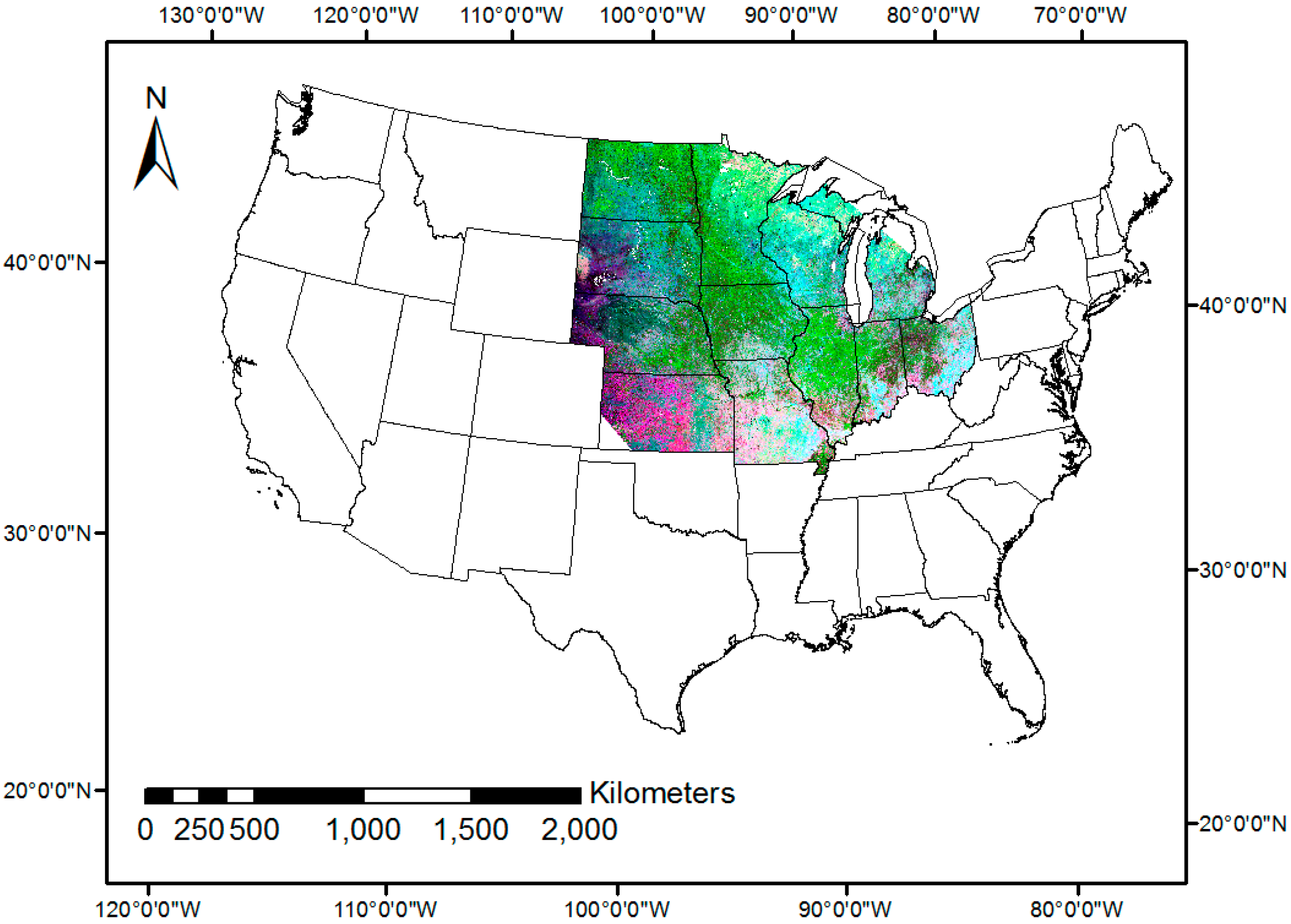
2.1. Study Area and Data Sets
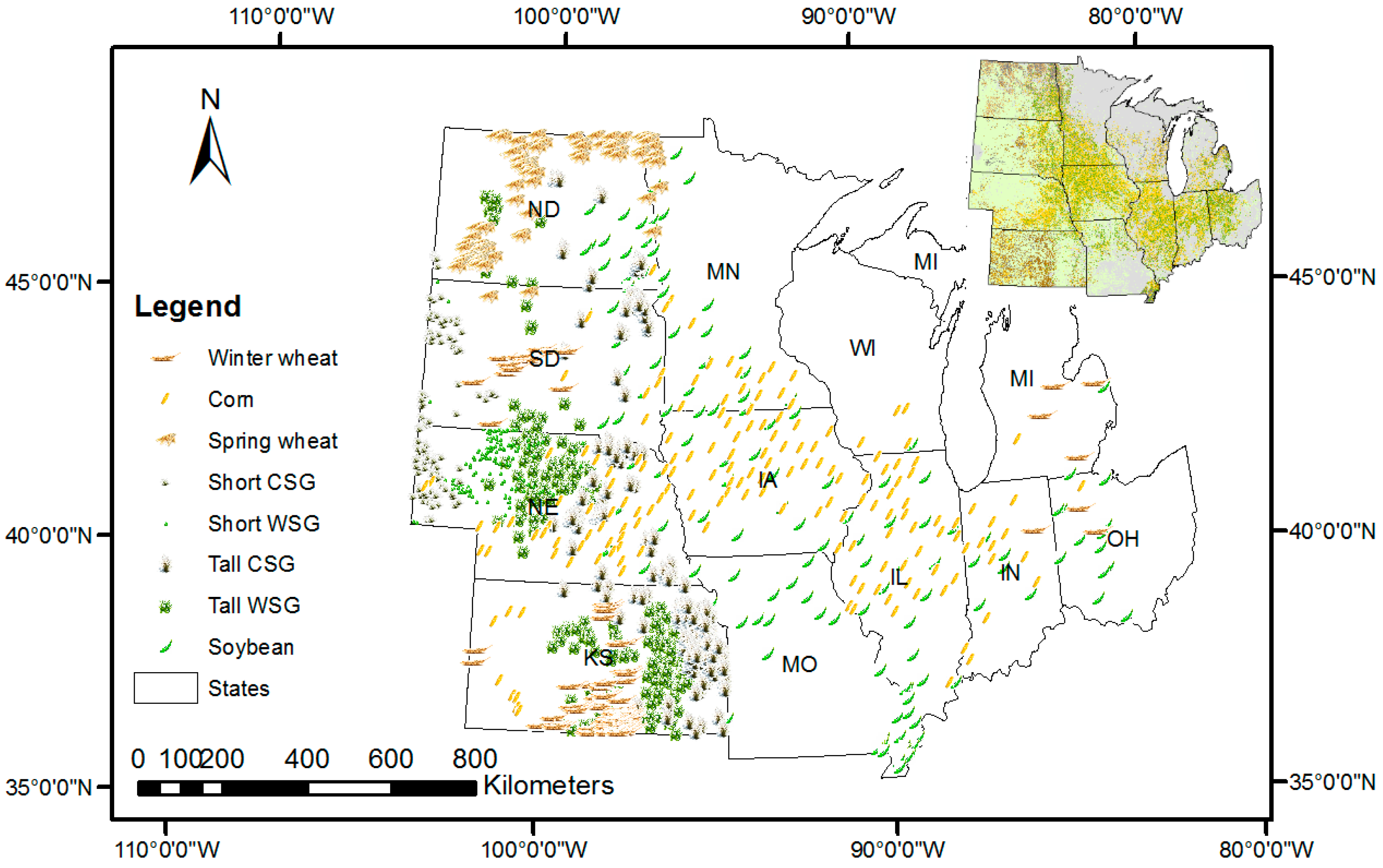
2.2. Methodology
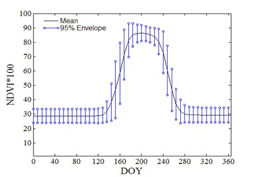
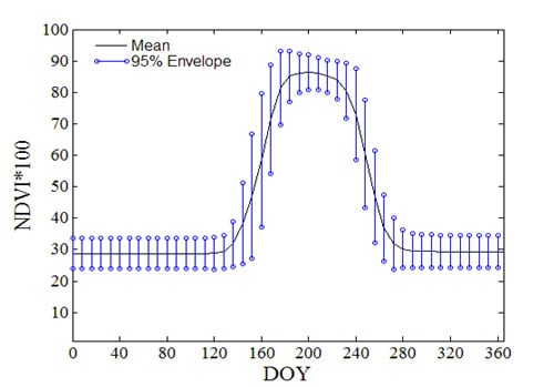
2.2.1. NDVI Time Series and Crop Phenology
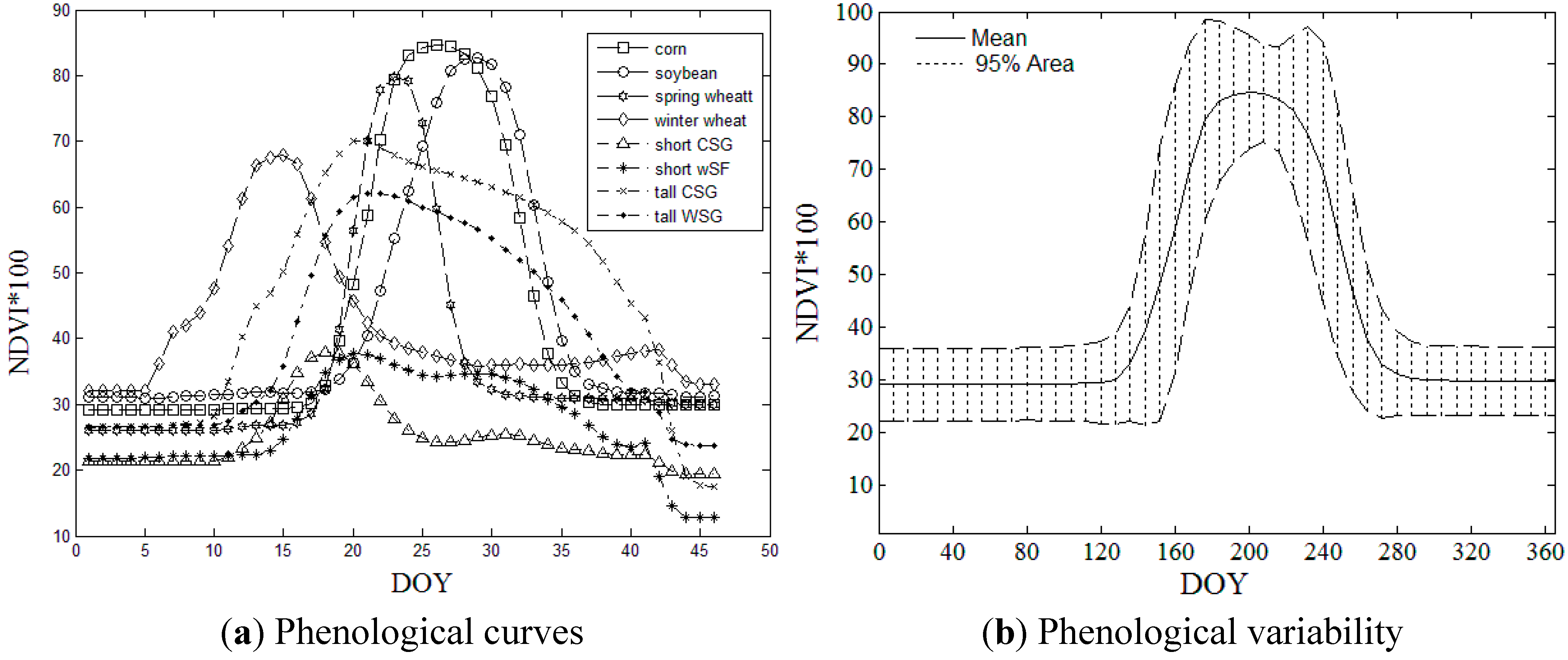

| Crops | Corn | Soybean | Spring Wheat | Winter Wheat | Short CSG | Short WSG | Tall CSG | Tall WSG |
|---|---|---|---|---|---|---|---|---|
| mean | 5.47 | 6.56 | 6.17 | 10.4 | 4.70 | 3.79 | 7.31 | 6.61 |
| stddev * | 3.13 | 2.64 | 2.14 | 2.94 | 1.28 | 1.79 | 3.40 | 2.49 |
2.2.2. Spatially Constrained Phenological Mixture Analysis (SPMA)
2.2.3. Accuracy Assessment
3. Results and Discussion
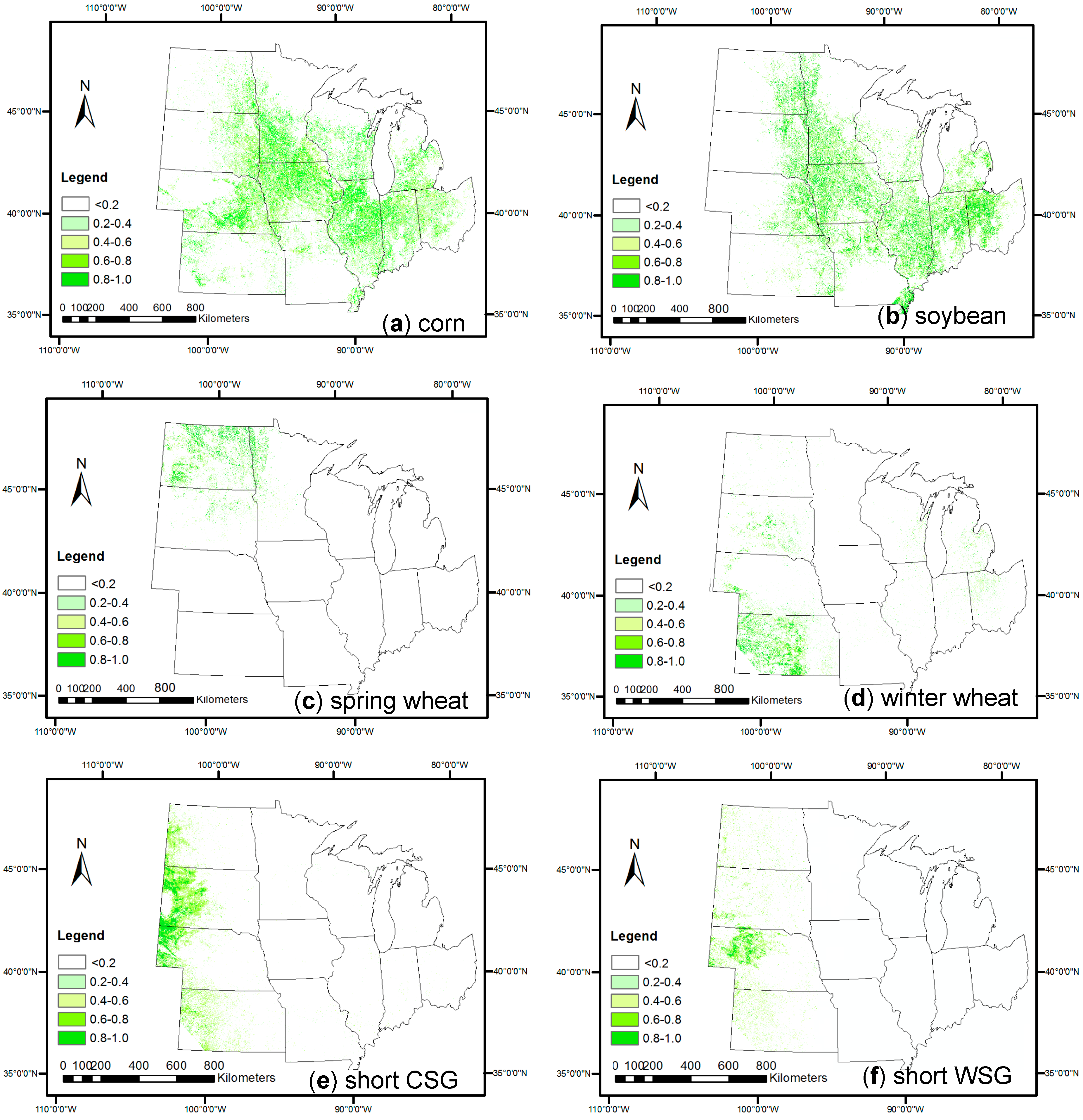
3.1. SPMA-Extracted Crop Percent Covers
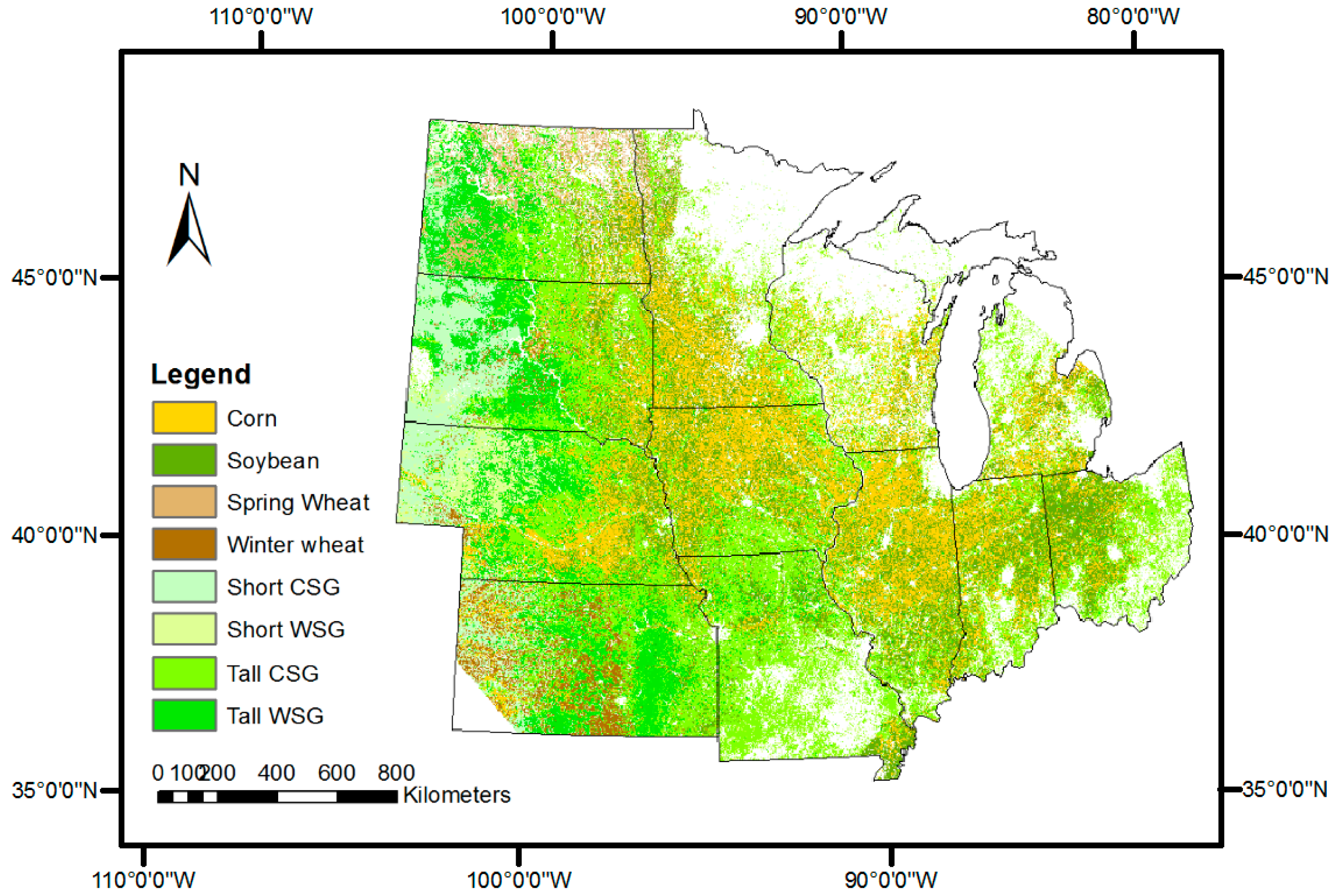

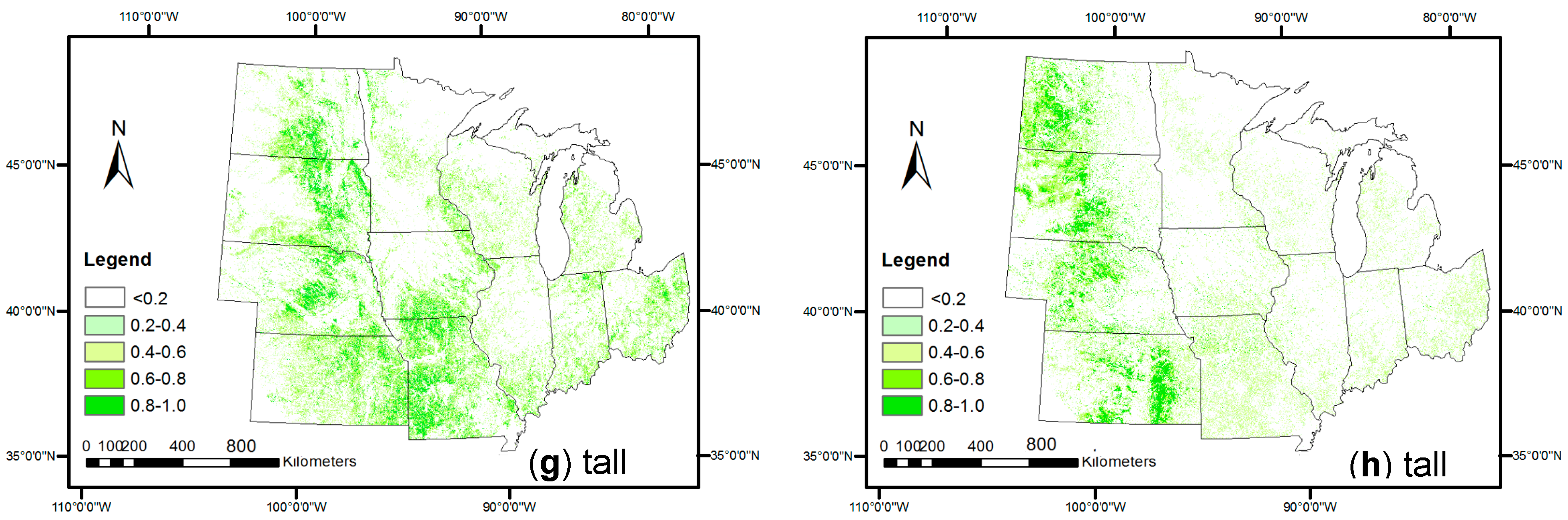
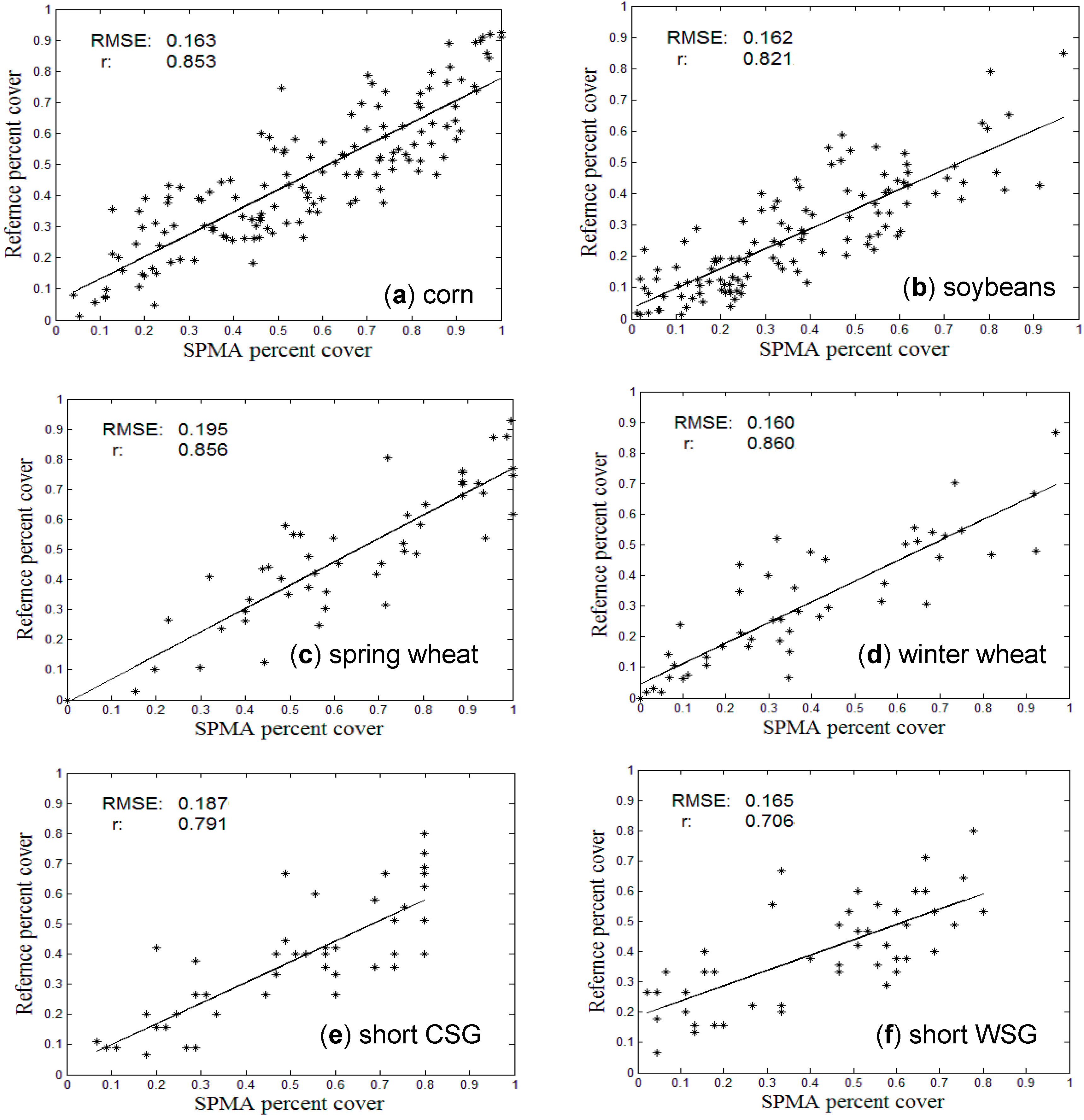
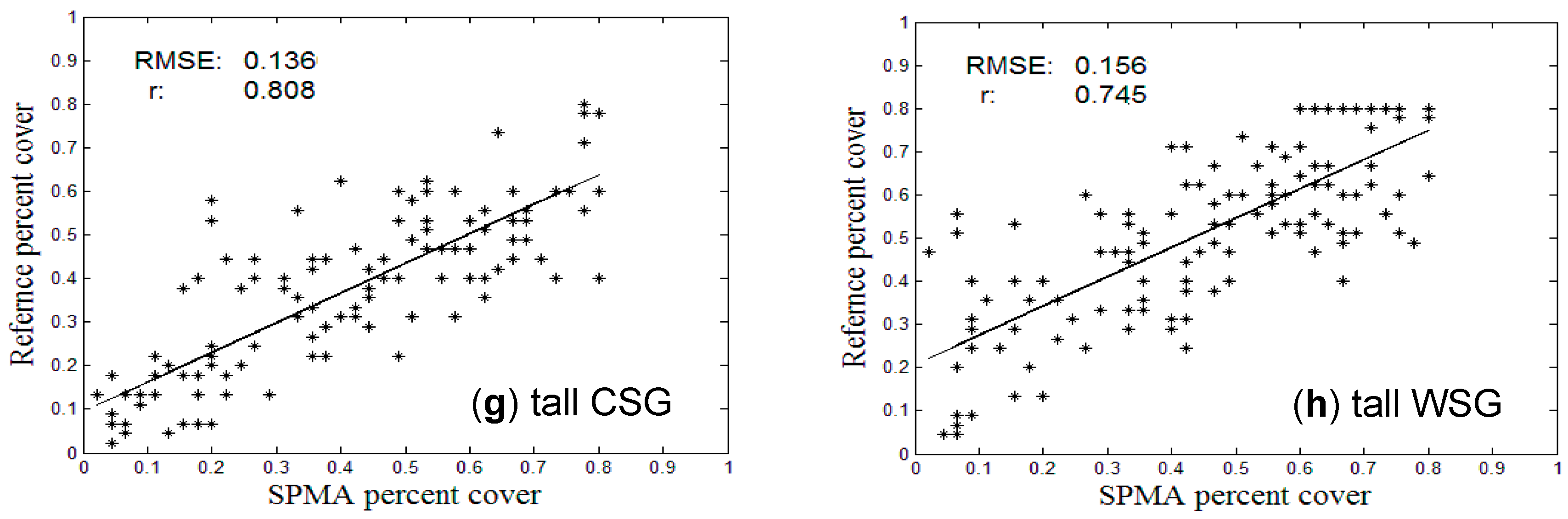
3.2. Comparison with References at Pixel Level
| Types | Corn | Soybean | Spring Wheat | Winter Wheat | Short CSG | Short WSG | Tall CSG | Tall WSG |
|---|---|---|---|---|---|---|---|---|
| RMSE | 0.163 | 0.162 | 0.195 | 0.160 | 0.187 | 0.165 | 0.136 | 0.156 |
| SE | –0.096 | –0.099 | –0.152 | –0.081 | –0.124 | –0.016 | 0.049 | 0.059 |
| Student’s t | 21.84 | 21.30 | 15.08 | 11.52 | 8.97 | 6.54 | 8.37 | 7.52 |
3.3. Comparison with Crop Census Records at County Level
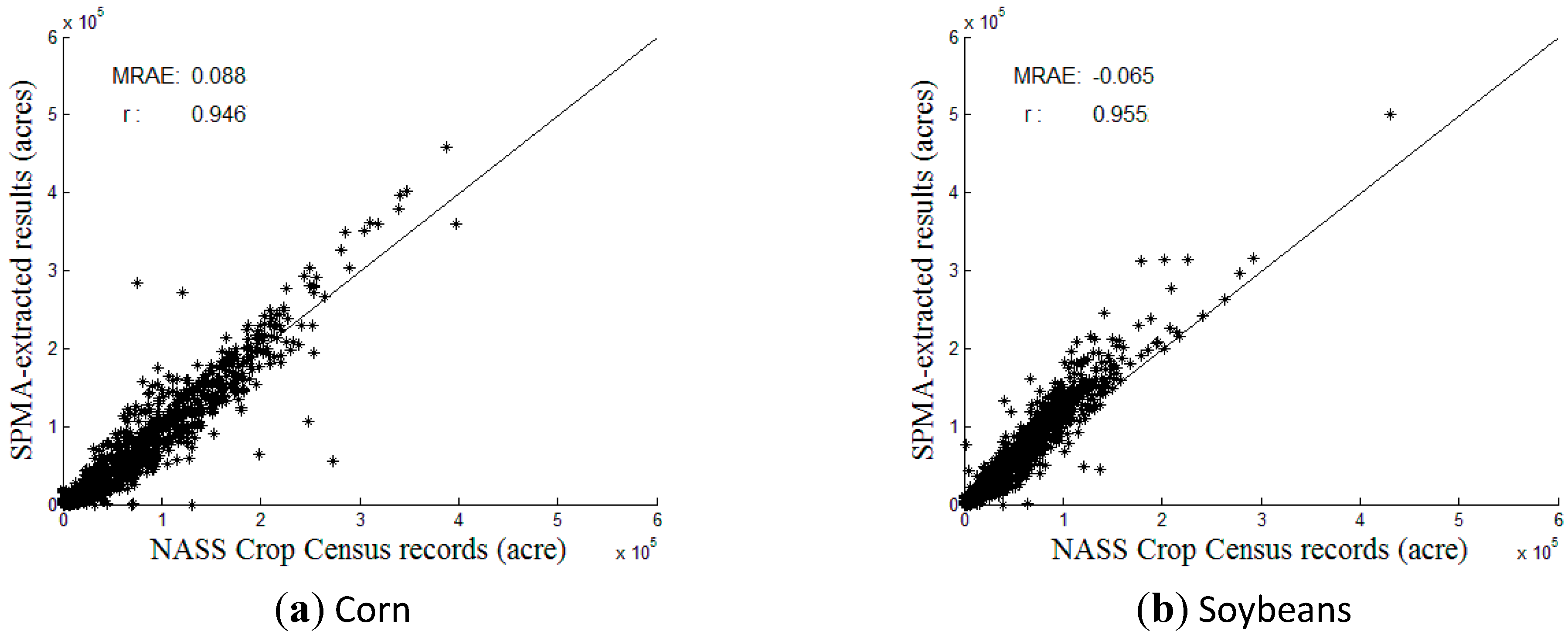
| Types | County Level | Region-Level (Midwest) | |||
|---|---|---|---|---|---|
| MRAE | r | SPMA Results (Million Acres) | NASS Census (Million Acres) | Ratio (SPMA/Census) | |
| Soybean | −0.065 | 0.955 | 61.616 | 52.702 | 116.91% |
4. Conclusions
Acknowledgements
Author Contributions
Conflicts of Interest
References
- 2007 Corn Crop A Record Breaker. Available online: http://www.nass.usda.gov/Newsroom/2008/01_11_2008.asp (accessed on 15 May 2014).
- Wang, C.; Fritschi, F.B.; Stacey, G.; Yang, Z. Phenology-based assessment of perennial energy crops in North American Tallgrass Prairie. Ann. Assoc. Am. Geogr. 2011, 101, 741–751. [Google Scholar] [CrossRef]
- Smith, W.K.; Cleveland, C.C.; Reed, S.C.; Miller, N.L.; Running, S.W. Bioenergy potential of the United States constrained by satellite observations of existing productivity. Environ. Sci. Tech. 2012, 46. [Google Scholar] [CrossRef]
- Boryan, C.; Yang, Z.; Mueller, R.; Craig, M. Monitoring US agriculture: The US department of agriculture, national agricultural statistics service, Cropland Data Layer Program. Geocarto Int. 2011, 26, 341–358. [Google Scholar] [CrossRef]
- Solomon, B.D.; Barnes, J.R.; Halvorsen, K.E. Grain and cellulosic ethanol: History, economics, and energy policy. Biomass Bioenerg. 2007, 31, 416–425. [Google Scholar] [CrossRef]
- Pittman, K.; Hansen, M.C.; Becker-Reshef, I.; Potapov, P.V.; Christopher, O.J. Estimating global cropland extent with multi-year MODIS data. Remote Sens. 2010, 2, 1844–1863. [Google Scholar] [CrossRef]
- Thenkabail, P.S.; Biradar, C.M.; Noojipady, P.; Dheeravath, V.; Li, Y.J.; Velpuri, M.; Gumma, M.; Reddy, G.P.O.; Turral, H.; Cai, X.L.; et al. Global Irrigated Area Map (GIAM), derived from remote sensing, for the end of the last millennium. Int. J. Remote Sens. 2009, 30, 3679–3733. [Google Scholar] [CrossRef]
- Thenkabail, P.S.; Hanjra, M.A.; Dheeravath, V.; Gumma, M.A. A holistic view of global croplands and their water use for ensuring global food security in the 21st century through advanced remote sensing and non-remote sensing approaches. Remote Sens. 2010, 2, 211–261. [Google Scholar] [CrossRef]
- Santos, U.L. Spectral identification of native and non-native plant species. In Proceedings of ASD and IEEE GRS; Art, Science and Applications of Reflectance Spectroscopy Symposium, Boulder, CO, USA, 23–25 February 2010.
- Xie, Y.; Sha, Z.; Yu, M. Remote sensing imagery in vegetation mapping: A review. J. Plant Ecol. 2008, 1, 9–23. [Google Scholar] [CrossRef]
- McCloy, K.R.; Lucht, W. Comparative evaluation of seasonal patterns in long time series of satellite image data and simulations of a global vegetation model. IEEE Trans. Geosci. Remote Sens. 2004, 42, 140–153. [Google Scholar] [CrossRef]
- Wang, C.; Jamison, B.; Spicci, A. Trajectory-based warm season grass mapping in Missouri prairies with multi-temporal ASTER imagery. Remote Sens. Environ. 2010, 114, 531–439. [Google Scholar] [CrossRef]
- Peterson, D.L.; Price, K.P.; Martinko, E.A. Discriminating between cool season and warm season grassland cover types in Northeaster Kansas. Int. J. Remote Sens. 2002, 23, 5015–5030. [Google Scholar] [CrossRef]
- Wardlow, B.D.; Egbert, S.L.; Kastens, J.H. Analysis of time-series MODIS 250 m vegetation index data for crop classification in the U.S. Central Great Plains. Remote Sens. Environ. 2007, 108, 290–310. [Google Scholar] [CrossRef]
- Wang, C.; Hunt, E.R.; Zhang, L.; Guo, H. Phenology-assisted classification of C3 and C4 grasses in the U.S. Great Plains and their climate dependency with MODIS time series. Remote Sens. Environ. 2013, 138, 90–101. [Google Scholar] [CrossRef]
- Homer, C.; Huang, C.; Yang, L.; Wylie, B.; Coan, M. Development of a 2001 national landcover database for the United States. Photogramm. Eng. Remote Sens. 2004, 70, 829–840. [Google Scholar] [CrossRef]
- Geerken, R.A. An algorithm to classify and monitor seasonal variations in vegetation phenologies and their inter-annual change. ISPRS J. Photogramm. Remote Sens. 2009, 64, 422–431. [Google Scholar] [CrossRef]
- Wardlow, B.D.; Egbert, S.L. Large-area crop mapping using time-series MODIS 250 m NDVI data: An assessment for the US Central Great Plains. Remote Sens. Environ. 2008, 112, 1096–1116. [Google Scholar] [CrossRef]
- Lobell, D.B.; Asner, G.P. Cropland distributions from temporal unmixing of MODIS data. Remote Sens. Environ. 2004, 93, 412–422. [Google Scholar] [CrossRef]
- Weng, Q.; Hu, X.; Lu, D. Extracting impervious surface from medium spatial resolution multispectral and hyperspectral imagery: A comparison. Int. J. Remote Sens. 2008, 29, 3209–3232. [Google Scholar] [CrossRef]
- Weng, Q. Remote sensing of impervious surfaces in the urban areas: Requirements, methods, and trends. Remote Sens. Environ. 2012, 117, 34–49. [Google Scholar] [CrossRef]
- Deng, C.; Wu, C. A spatially adaptive spectral mixture analysis for mapping subpixel urban impervious surface distribution. Remote Sens. Environ. 2013, 133, 62–70. [Google Scholar] [CrossRef]
- Busetto, L.; Meroni, M.; Colombo, R. Combining medium and coarse spatial resolution satellite data to improve the estimation of sub-pixel NDVI time series. Remote Sens. Environ. 2008, 112, 118–131. [Google Scholar] [CrossRef]
- Ozdogan, M. The spatial distribution of crop types from MODIS data: Temporal unmixing using independent component analysis. Remote Sens. Environ. 2010, 114, 1190–1204. [Google Scholar] [CrossRef]
- Somers, B.; Asner, G.P.; Tits, L.; Coppin, P. Endmember variability in spectral mixture analysis: A review. Remote Sens. Environ. 2011, 115, 1603–1616. [Google Scholar] [CrossRef]
- Ethanol Facilities’ Capacity by State. Available online: http://www.neo.ne.gov/statshtml/121.htm. (accessed on 15 May 2014).
- Savitzky, A.; Golay, M.J.E. Smoothing and differentiation of data by simplified least squares procedures. Anal. Chem. 1964, 36, 1627–1639. [Google Scholar] [CrossRef]
- Cropland Layer Data. Available online: http://nassgeodata.gmu.edu/CropScape/ (accessed on 15 May 2014).
- Hu, X.; Weng, Q. Estimating impervious surfaces from medium spatial resolution imagery using the self-organizing map and multi-layer perceptron neural networks. Remote Sens. Environ. 2009, 113, 2089–2102. [Google Scholar] [CrossRef]
- Wang, C.; Zhong, C.; Yang, Z. Assessing bioenergy-driven agricultural land use change and biomass quantities in the U.S. Midwest with MODIS time series. J. Appl. Remote Sens. 2014, 8. [Google Scholar] [CrossRef]
- Zhu, X.; Cheng, J.; Gao, F.; Chen, X.; Masek, J.G. An enhanced spatial and temporal adaptive reflectance fusion model for complex heterogeneous regions. Remote Sens. Environ. 2010, 114, 2610–2623. [Google Scholar] [CrossRef]
© 2015 by the authors; licensee MDPI, Basel, Switzerland. This article is an open access article distributed under the terms and conditions of the Creative Commons Attribution license (http://creativecommons.org/licenses/by/4.0/).
Share and Cite
Zhong, C.; Wang, C.; Wu, C. MODIS-Based Fractional Crop Mapping in the U.S. Midwest with Spatially Constrained Phenological Mixture Analysis. Remote Sens. 2015, 7, 512-529. https://doi.org/10.3390/rs70100512
Zhong C, Wang C, Wu C. MODIS-Based Fractional Crop Mapping in the U.S. Midwest with Spatially Constrained Phenological Mixture Analysis. Remote Sensing. 2015; 7(1):512-529. https://doi.org/10.3390/rs70100512
Chicago/Turabian StyleZhong, Cheng, Cuizhen Wang, and Changshan Wu. 2015. "MODIS-Based Fractional Crop Mapping in the U.S. Midwest with Spatially Constrained Phenological Mixture Analysis" Remote Sensing 7, no. 1: 512-529. https://doi.org/10.3390/rs70100512
APA StyleZhong, C., Wang, C., & Wu, C. (2015). MODIS-Based Fractional Crop Mapping in the U.S. Midwest with Spatially Constrained Phenological Mixture Analysis. Remote Sensing, 7(1), 512-529. https://doi.org/10.3390/rs70100512