Actual Evapotranspiration (Water Use) Assessment of the Colorado River Basin at the Landsat Resolution Using the Operational Simplified Surface Energy Balance Model

 ,
,
Abstract
:1. Introduction
2. Methods and Materials
2.1. The Operational Simplified Surface Energy Balance (SSEBop) Model
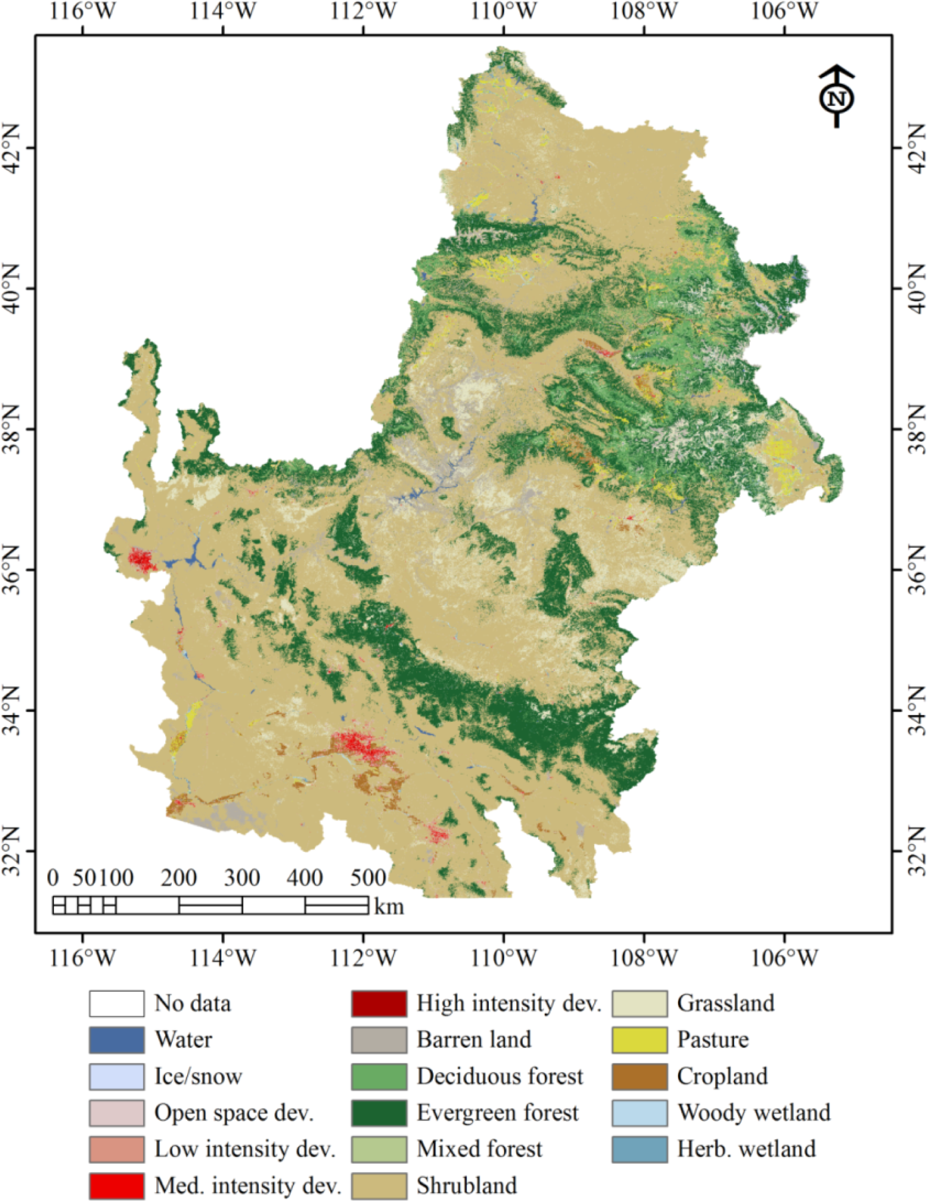
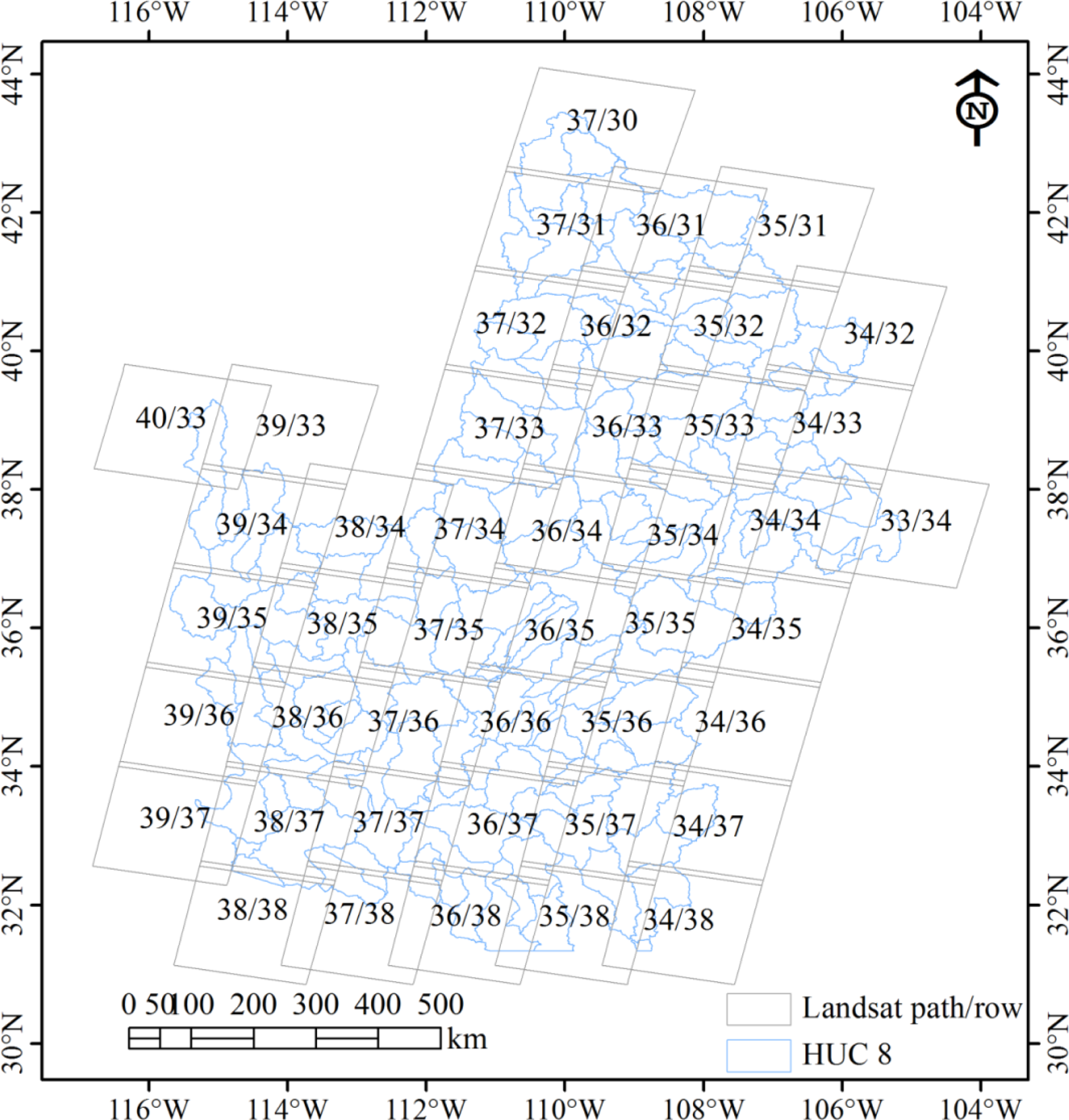
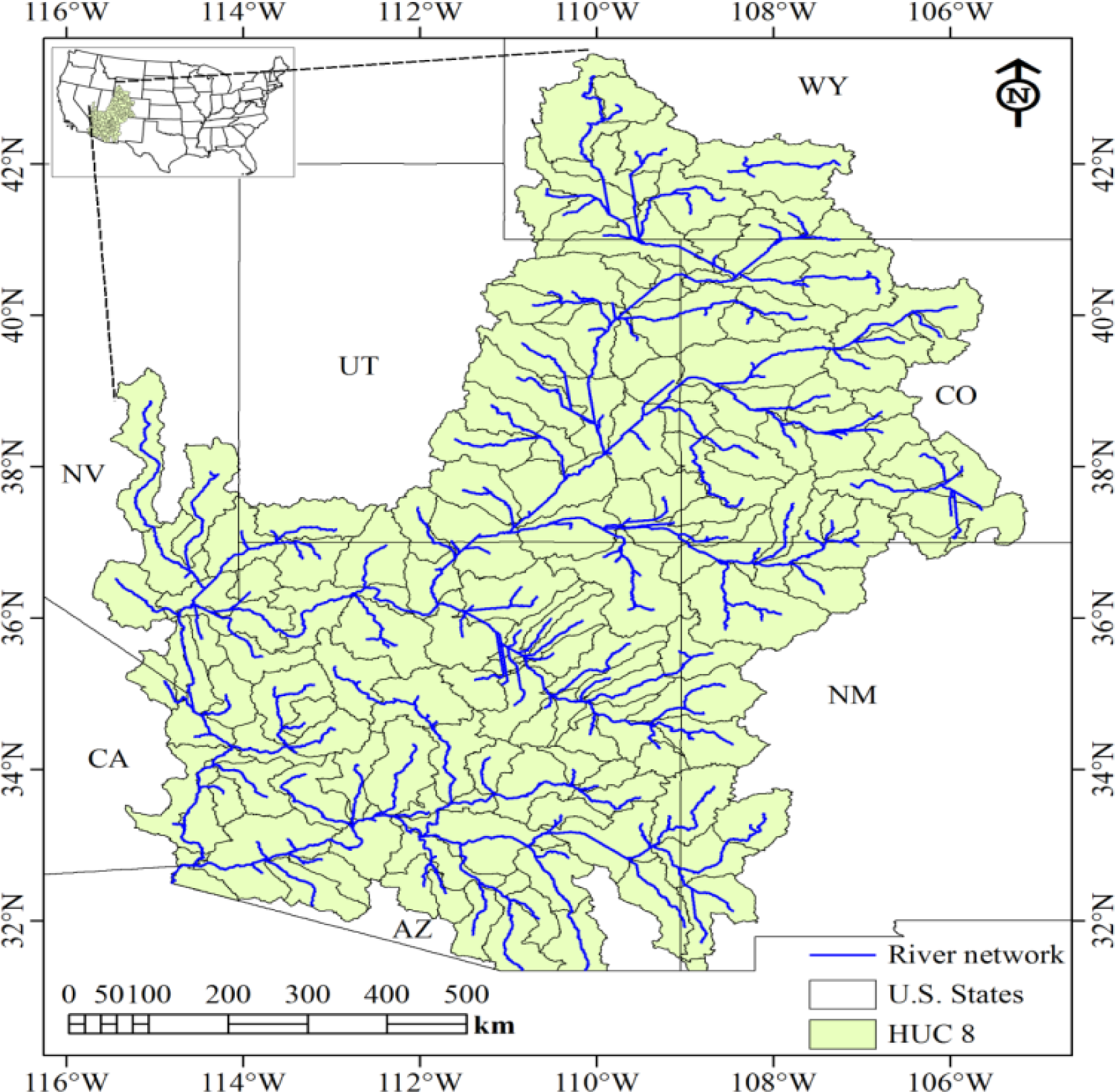
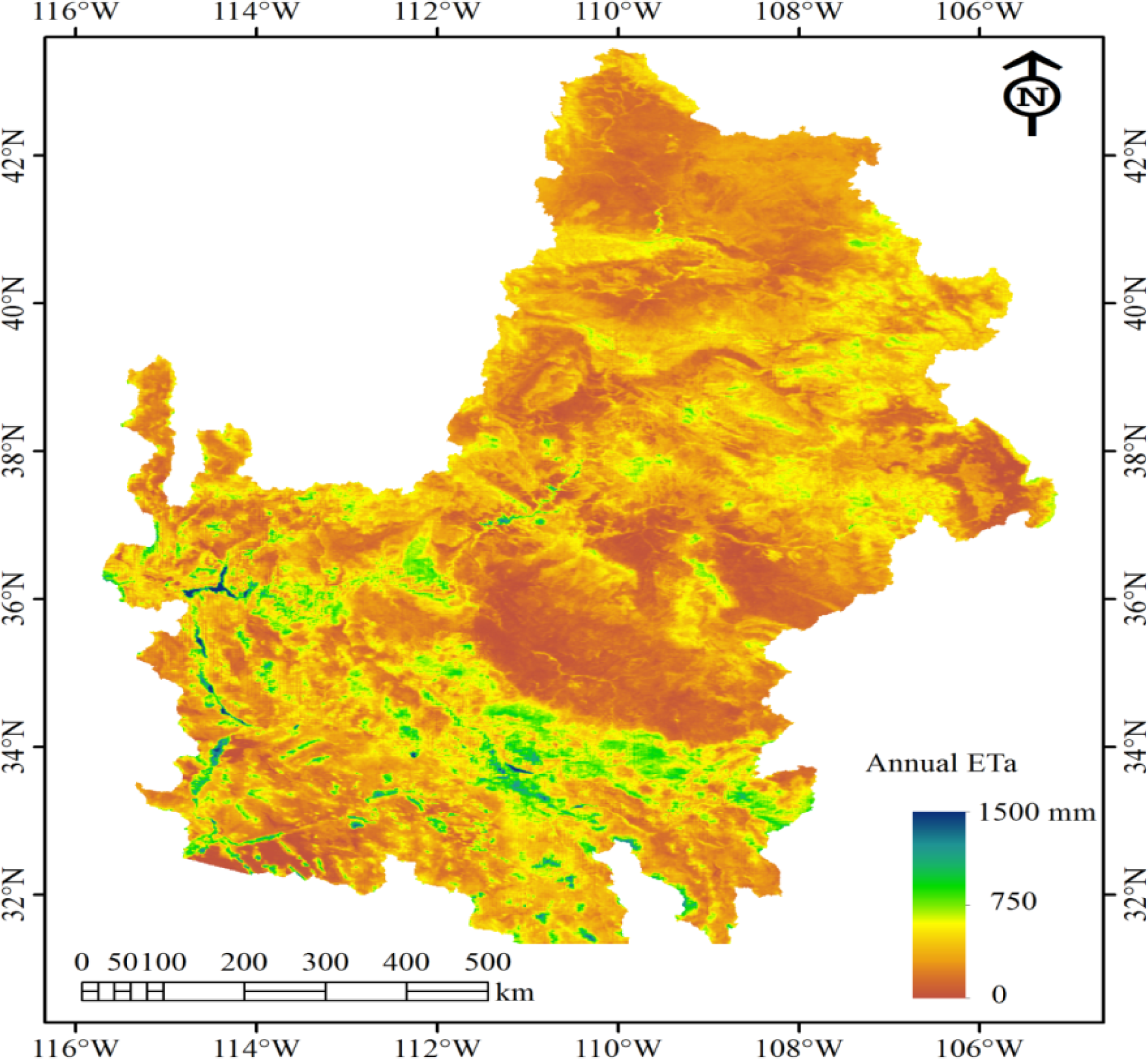
2.2. Study Area
2.3. Processing of Landsat Images
2.4. Other Supporting Data
2.5. Computation of Annual Evapotranspiration
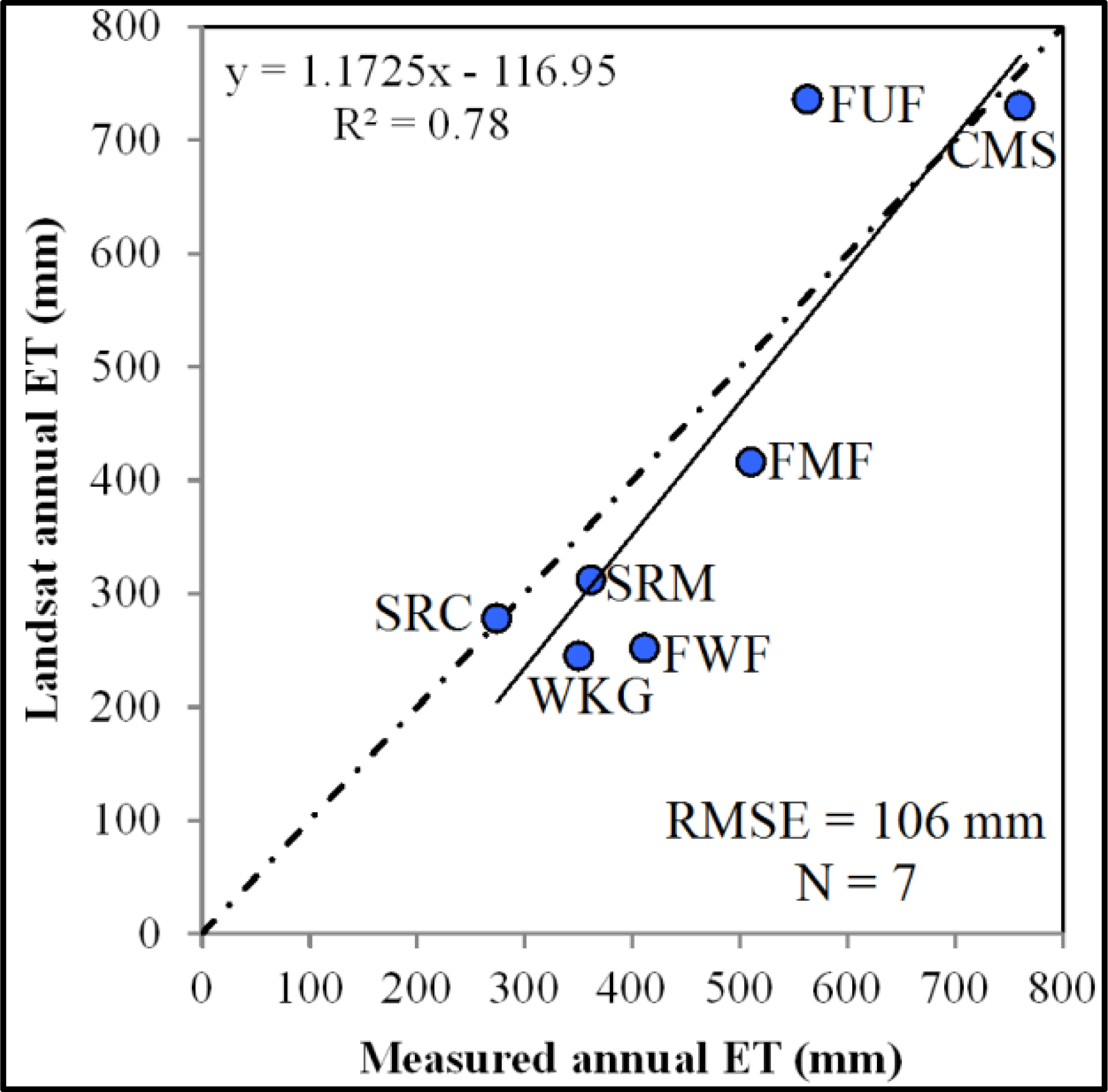
2.6. Field Validation
3. Results and Discussion
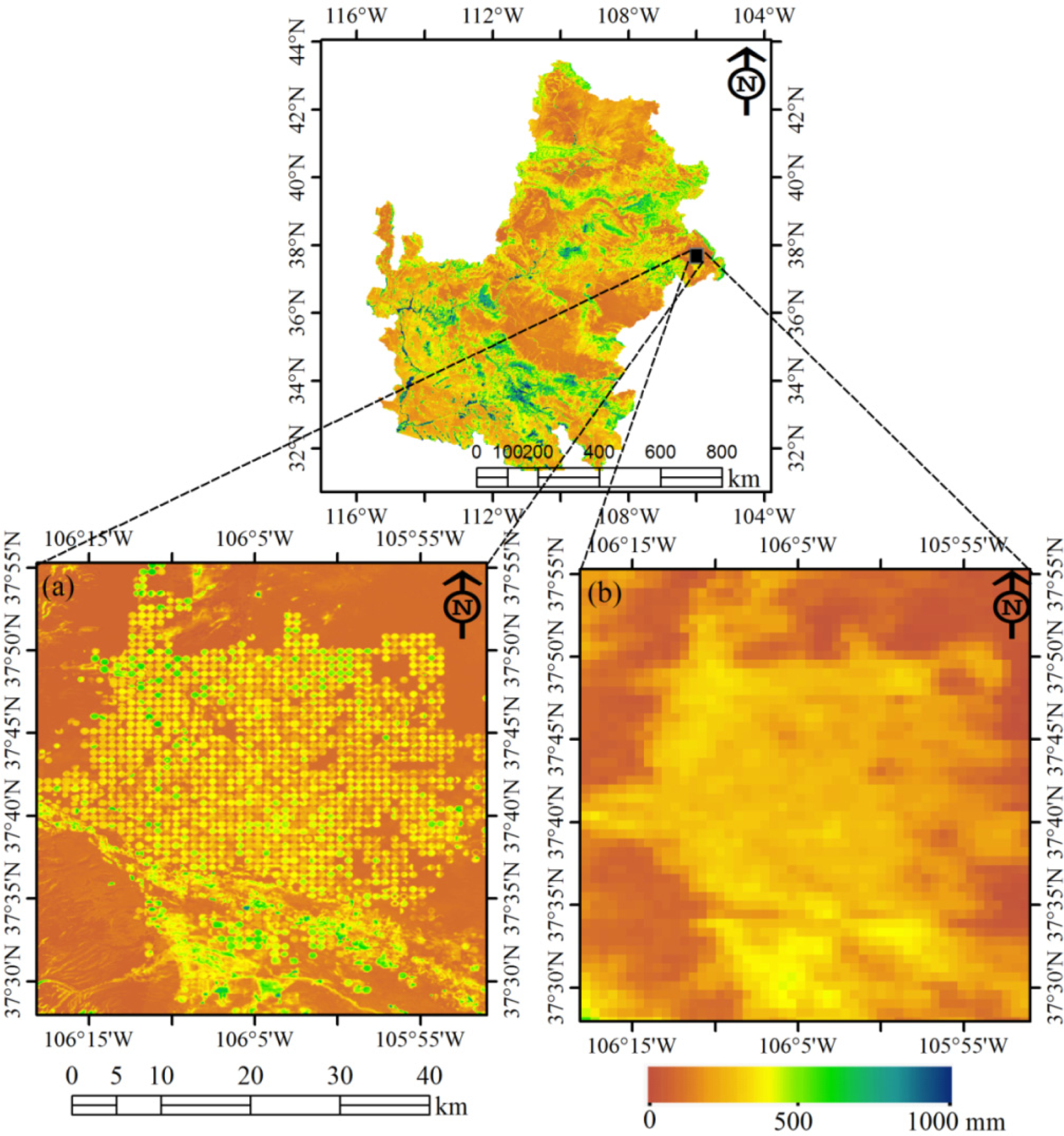
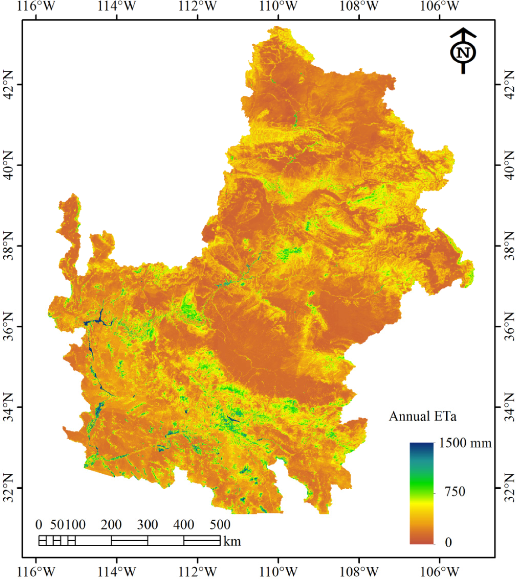
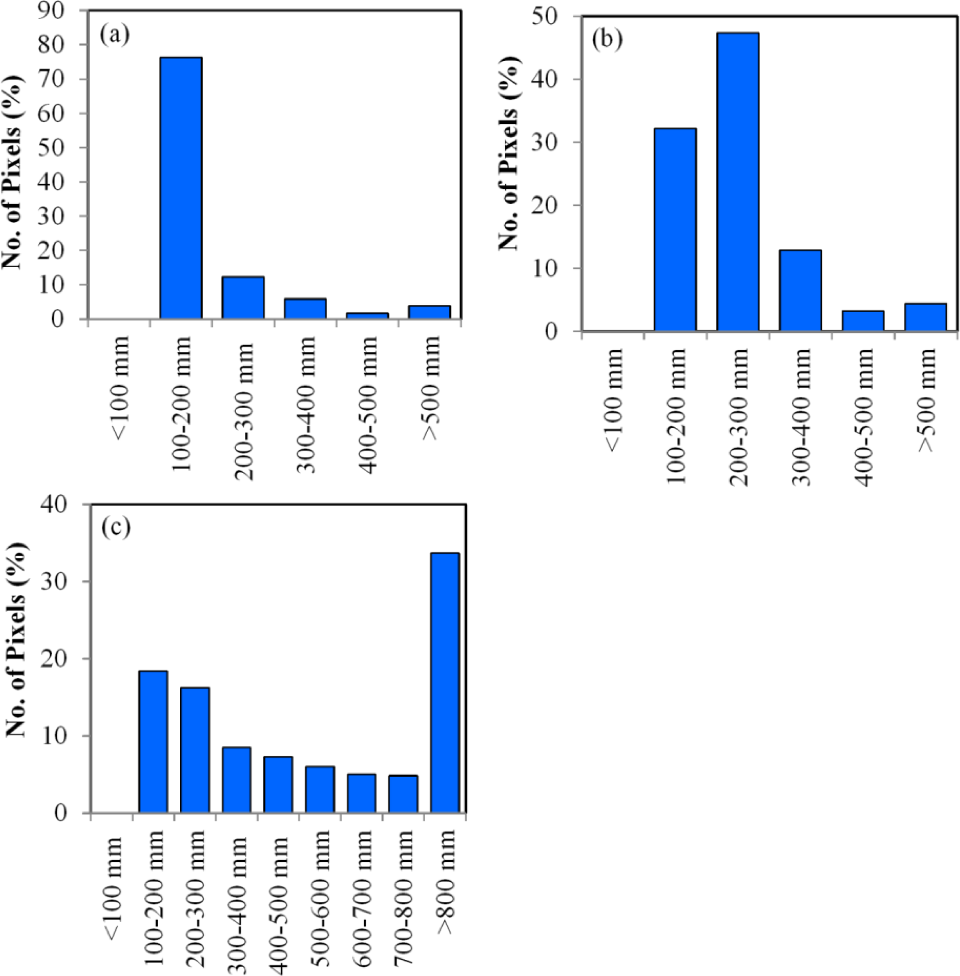
3.1. Annual ETa of Different Land Use/Land Cover
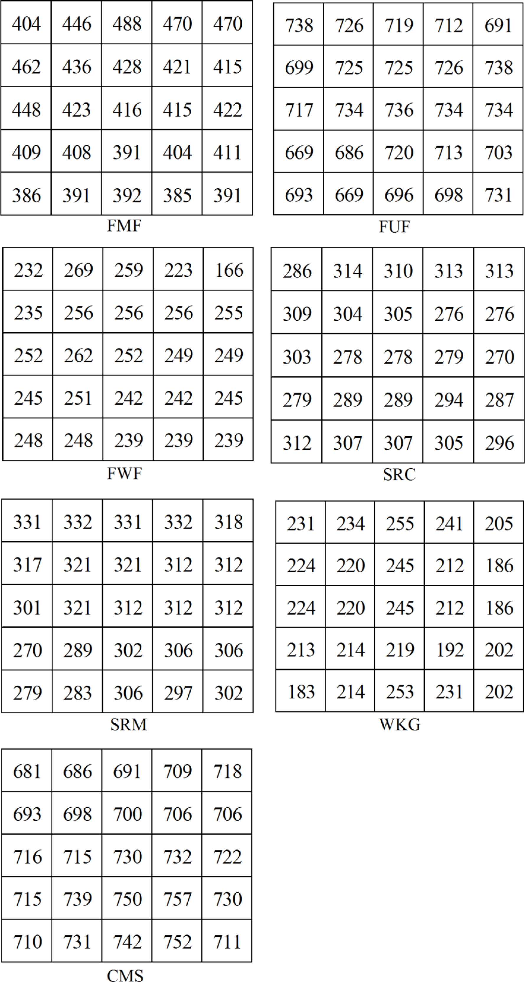
3.2. Validation with Eddy Covariance Measurement
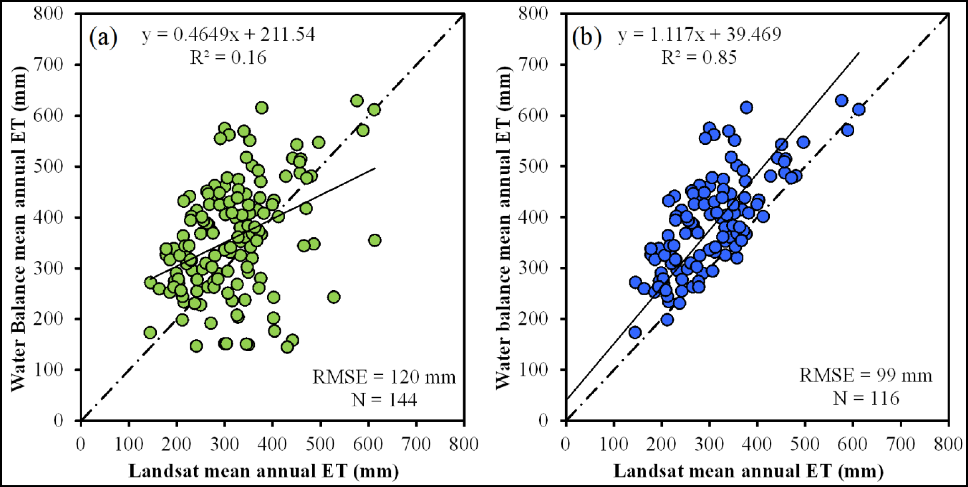
3.3. Comparison with Annual ETa Based on Water Balance Analysis
3.4. Comparison with MODIS-Based Annual ETa
4. Conclusions
Acknowledgments
Conflicts of Interest
References
- Christensen, N.S.; Wood, A.W.; Voisin, N.; Lettenmaier, D.P.; Palmer, R.N. The effects of climate change on the hydrology and water resources of the Colorado River Basin. Clim. Chang 2004, 62, 337–363. [Google Scholar]
- McCabe, G.J.; Wolock, D.M. Warming may create substantial water supply shortages in the Colorado River Basin. Geophys. Res. Lett 2007, 34, L22708. [Google Scholar]
- Bastiaanssen, W.G.M.; Molden, D.J.; Makin, I.W. Remote sensing for irrigated agriculture: Examples from research and possible applications. Agric. Water Manag 2000, 46, 137–155. [Google Scholar]
- Nagler, P.L.; Glenn, E.P.; Didan, K.; Osterberg, J.; Jordan, F.; Cunningham, J. Wide-area estimates of stand structure and water use of Tamarix spp. on the Lower Colorado River: Implications for restoration and water management projects. Restor. Ecol 2008, 16, 136–145. [Google Scholar]
- Gowda, P.H.; Chavez, J.L.; Colaizzi, P.D.; Evett, S.R.; Howell, T.A.; Tolk, J.A. ET Mapping for agricultural water management: Present status and challenges. Irrig. Sci 2008, 26, 223–237. [Google Scholar]
- Menenti, M.; Chaudhury, B.J. Parameterization of Land Surface Evapotranspiration Using a Location Dependent Potential Evapotranspiration and Surface Temperature Range. Proceedings of the Exchange Processes at the Land Surface for a Range of Space and Time Scales; Bolle, H.J., Feddes, R.A., Kalma, J.D., Eds.; International Association of Hydrological Sciences: Rennes, France, 1993; 212, pp. 561–568. [Google Scholar]
- Norman, J.M.; Kustas, W.P.; Humes, K.S. A two-source approach for estimating soil and vegetation energy fluxes from observations of directional radiometric surface temperature. Agric. For. Meteorol 1995, 77, 263–293. [Google Scholar]
- Bastiaanssen, W.G.M.; Menenti, M.; Feddes, R.A.; Holtslag, A.A.M. The surface energy balance algorithm for land (SEBAL): Part 1 Formulation. J. Hydrol 1998, 212–213, 198–212. [Google Scholar]
- Roerink, G.J.; Su, Z.; Menenti, M. S-SEBI: A simple remote sensing algorithm to estimate the surface energy balance. Phys. Chem. Earth Part B 2000, 25, 147–157. [Google Scholar]
- Su, Z. The Surface Energy Balance System (SEBS) for estimation of turbulent heat fluxes. Hydrol. Earth Syst. Scie 2002, 6, 85–99. [Google Scholar]
- Loheide, S.P., II; Gorelick, S.M. A local-scale, high resolution evapotranspiration mapping algorithm (ETMA) with hydroecological applications at riparian meadow restoration sites. Remote Sens. Environ 2005, 98, 182–200. [Google Scholar]
- Anderson, M.C.; Norman, J.M.; Mecikalski, J.R.; Otkin, J.A.; Kustas, W.P. A Climatological study of evapotranspiration and moisture stress across the continental United States based on thermal remote sensing: 1 Model formulation. J. Geophys. Res 2007. [Google Scholar] [CrossRef]
- Allen, R.G.; Tasumi, M.; Trezza, R. Satellite-based energy balance for mapping evapotranspiration with internalized calibration (METRIC)—Model. ASCE J. Irrig. Drain. Eng 2007, 133, 380–394. [Google Scholar]
- Senay, G.B.; Budde, M.E.; Verdin, J.P.; Melesse, A.M. A coupled remote sensing and Simplified Surface Energy Balance (SSEB) approach to estimate actual evapotranspiration from irrigated fields. Sensors 2007, 7, 979–1000. [Google Scholar]
- Singh, R.K.; Irmak, A. Treatment of anchor pixels in the METRIC model for improved estimation of sensible and latent heat fluxes. Hydrol. Sci. J 2011, 56, 895–906. [Google Scholar]
- Senay, G.B.; Bohms, S.; Singh, R.K.; Gowda, P.H.; Velpuri, N.M.; Alemu, H.; Verdin, J.P. Operational evapotranspiration mapping using remote sensing and weather datasets: A new parameterization for the SSEB approach. J. Am. Water Resourc. Assoc 2013, 49, 577–591. [Google Scholar]
- Gowda, P.H.; Chavez, J.L.; Colaizzi, P.D.; Evett, S.R.; Howell, T.A.; Tolk, J.A. Remote sensing based energy balance algorithms for mapping ET: Current status and future challenges. Trans. Am. Soc. Agric. Biol. Eng 2007, 50, 1639–1644. [Google Scholar]
- Kalma, J.D.; McVicar, T.R.; McCabe, M.F. Estimating land surface evaporation: A review of methods using remotely sensed surface temperature data. Surv. Geophys 2008, 29, 421–469. [Google Scholar]
- Glenn, E.P.; Neale, C.M.U.; Hunsaker, D.J.; Nagler, P.L. Vegetation index-based crop coefficients to estimate evapotranspiration by remote sensing in agricultural and natural ecosystems. Hydrol. Process 2011, 25, 4050–4062. [Google Scholar]
- US Geological Survey (USGS). Facing Tomorrow’S Challenges—U.S. Geological Survey Science in the Decade 2007–2017. US Geol. Surv. Circ 2007, 1309, 1–69. [Google Scholar]
- US Department of the Interior (DOI). Fiscal Year 2011 The Interior Budget in Brief. In WaterSMART: Departmental Highlights; US Department of the Interior: Washington, DC, USA, 2010; pp. 19–25. [Google Scholar]
- Bruce, B.W. WaterSMART—The Colorado River Basin Focus Area Study; US Geological Survey: Washington, DC, USA.
- Allen, R.G.; Pereira, L.S.; Raes, D.; Smith, M. Crop Evapotranspiration: Guidelines for Computing Crop Water Requirements; FAO: Rome, Italy, 1998. [Google Scholar]
- Fry, J.; Xian, G.; Jin, S.; Dewitz, J.; Homer, C.; Yang, L.; Barnes, C.; Herold, N.; Wickham, J. Completion of the 2006 national land cover database for the conterminous United States. Photogramm. Eng. Remote Sens 2011, 77, 858–864. [Google Scholar]
- Bureau of Reclamation (BOR). Lower Colorado River Accounting System, Demonstration of Technology; Lower Colorado Regional Office: Boulder City, NV, 1997. [Google Scholar]
- Congalton, R.G.; Balogh, M.; Bell, C.; Green, K.; Milliken, J.A.; Ottman, R. Mapping and monitoring agricultural crops and other land cover in the Lower Colorado River Basin. Photogramm. Eng. Remote Sens 1998, 64, 1107–1114. [Google Scholar]
- Kumar, M.; Duffy, C.J. Detecting hydroclimatic change using spatio-temporal analysis of time series in Colorado River Basin. J. Hydrol 2009, 374, 1–15. [Google Scholar]
- Chander, G.; Markham, B.L.; Helder, D.L. Summary of current radiometric calibration coefficients for Landsat MSS, TM, ETM+, and EO-1 ALI sensors. Remote Sens. Environ 2009, 113, 893–903. [Google Scholar]
- Tasumi, M.; Allen, R.; Trezza, R. At-surface reflectance and albedo from satellite for operational calculation of land surface energy balance. J. Hydrol. Eng 2008, 13, 51–63. [Google Scholar]
- Daly, C.; Gibson, W.P.; Taylor, G.H.; Johnson, G.L.; Pasteris, P. A knowledge-based approach to the statistical mapping of climate. Clim. Res 2002, 22, 99–113. [Google Scholar]
- US Geological Survey (USGS). Waterwatch–Maps, Graphs, and Tables of Current, Recent, and Past Streamflow Conditions. Available online: http://pubs.usgs.gov/fs/2008/3031/ (accessed on 31 December 2012).
- Reuter, H.I.; Nelson, A.; Jarvis, A. An evaluation of void filling interpolation methods for SRTM data. Int. J. Geogr. Inf. Sci 2007, 21, 983–1008. [Google Scholar]
- Senay, G.B; Verdin, J.P.; Lietzow, R.; Melesse, A.M. Global reference evapotranspiration modeling and evaluation. J. Am. Water Resourc. Assoc 2008, 44, 969–979. [Google Scholar]
- Kanamitsu, M. Description of the NMC global data assimilation and forecast system. Weather Forecast 1989, 4, 335–342. [Google Scholar]
- Jung, M.; Reichstein, M.; Bondeau, A. Towards global empirical upscaling of FLUXNET eddy covariance observations: Validation of a model tree ensemble approach using a biosphere model. Biogeosciences 2009, 6, 2001–2013. [Google Scholar]
- Singh, R.K. Geospatial Approach for Estimating Land Surface Evapotranspiration. Ph.D. Dissertation,. University of Nebraska-Lincoln: Lincoln, NE, USA, 2009. [Google Scholar]
- Singh, R.K.; Liu, S.; Tieszen, L.L.; Suyker, A.E.; Verma, S.B. Estimating seasonal evapotranspiration from temporal satellite images. Irrig. Sci 2012, 30, 303–313. [Google Scholar]
- Dore, S.; Montes-Helu, M.; Hart, S.C.; Hungate, B.A.; Koch, G.W.; Moon, J.B.; Finkral, A.J.; Kolb, T.E. Recovery of ponderosa pine ecosystem carbon and water fluxes from thinning and stand-replacing fire. Glob. Chang. Biol 2012, 18, 3171–3185. [Google Scholar]
- Kurc, S.A.; Benton, L.M. Digital image-derived greenness links deep soil moisture to carbon uptake in a creosotebush-dominated shrubland. J. Arid Environ 2010, 74, 585–594. [Google Scholar]
- Scott, R.L.; Jenerette, G.D.; Potts, D.L.; Huxman, T.E. Effects of seasonal drought on net carbon dioxide exchange from a woody-plant-encroached semiarid grassland. J. Geophys. Res.: Biogeosci 2009, 114, G04004. [Google Scholar]
- Scott, R.L.; Hamerlynck, E.P.; Jenerette, G.D.; Moran, M.S.; Barron-Gafford, G. Carbon dioxide exchange in a semidesert grassland through drought-induced vegetation change. J. Geophys. Res.: Biogeosci 2010. [Google Scholar] [CrossRef]
- Scott, R.L.; Edwards, E.A.; Shuttleworth, W.J.; Huxman, T.E.; Watts, C.; Goodrich, D.C. Interannual and seasonal variation in fluxes of water and carbon dioxide from a riparian woodland ecosystem. Agric. For. Meteorol 2004, 122, 65–84. [Google Scholar]
- Baldocchi, D.; Falge, E.; Gu, L.; Olson, R.; Hollinger, D.; Running, S.; Anthoni, P.; Bernhofer, C.; Davis, K.; Evans, R.; et al. FLUXNET: A new tool to study the temporal and spatial variability of ecosystem-scale carbon dioxide, water vapor, and energy flux densities. Bull. Am. Meteorol. Soc 2001, 82, 2415–2431. [Google Scholar]
- Barron-Gafford, G.A.; Scott, R.L.; Jenerette, G.D.; Hamerlynck, E.P.; Huxman, T.E. Temperature and precipitation controls over leaf and ecosystem-level CO2 flux along a woody plant encroachment gradient. Glob. Chang. Biol 2012, 18, 1389–1400. [Google Scholar]
- Wickham, J.D.; Stehman, S.V.; Gass, L.; Dewitz, J.; Fry, J.A.; Wade, T.G. Accuracy assessment of NLCD 2006 land cover and impervious surface. Remote Sens. Environ 2013, 130, 294–304. [Google Scholar]
- Stehman, S.V.; Milliken, J.A. Estimating the effect of crop classification error on evapotranspiration derived from remote sensing in the Lower Colorado River basin, USA. Remote Sens. Environ 2007, 106, 217–227. [Google Scholar]
- Haddeland, I.; Lettenmaier, D.P.; Skaugen, T. Effects of irrigation on the water and energy balances of the Colorado and Mekong River basins. J. Hydrol 2006, 324, 210–223. [Google Scholar]
- Westenburg, C.L.; Harper, D.P.; DeMeo, G.A. Evapotranspiration by Phreatophytes along the Lower Colorado River at Havasu National Wildlife Refuge, Arizona; US Geological Survey Scientific Investigations Report 2006–5043; US Department of the Interior: Washington, DC, USA, 2006; p. 44. [Google Scholar]
- Doody, T.M.; Nagler, P.M.; Glenn, E.P.; Moore, G.W.; Morino, K.; Hultine, K.R.; Benyon, R.G. Potential for water salvage by removal of non-native woody vegetation from dryland river systems. Hydrol. Process 2011, 25, 4117–4131. [Google Scholar]
- Nagler, P.L.; Scott, R.L.; Westenburg, C.; Cleverly, J.R.; Glenn, E.P.; Huete, A.R. Evapotranspiration on western US rivers estimated using the enhanced vegetation index from MODIS and data from eddy covariance and Bowen ratio flux towers. Remote Sens. Environ 2005, 97, 337–351. [Google Scholar]
- Leclerc, M.Y.; Thurtell, G.W. Footprint prediction of scalar fluxes using a Markovian analysis. Bound.-Lay. Meteorol 1990, 52, 247–258. [Google Scholar]
- Bastiaanssen, W.G. SEBAL-based sensible and latent heat fluxes in the irrigated Gediz Basin, Turkey. J. Hydrol 2000, 229, 87–100. [Google Scholar]
- Twine, T.E; Kustas, W.P.; Norman, J.M.; Cook, D.R.; Houser, P.R.; Meyers, T.P.; Prueger, J.H.; Starks, P.J.; Wesely, M.L. Correcting eddy covariance flux underestimates over a grassland. Agric. For. Meteorol 2000, 103, 279–300. [Google Scholar]
- Wilson, K.; Goldstein, A.; Falge, E.; Aubinet, M.; Baldocchi, D.; Berbigier, P.; Bernhofer, C.; Ceulemans, R.; Dolman, H.; Field, C.; et al. Energy balance closure at FLUXNET sites. Agric. For. Meteoro 2002, 113, 223–243. [Google Scholar]
- Hollinger, D.Y.; Richardson, A.D. Uncertainty in eddy covariance measurements and its application to physiological models. Tree Physiol 2005, 25, 873–885. [Google Scholar]
- Velpuri, N.M.; Senay, G.B.; Singh, R.K.; Bohms, S.; Verdin, J.P. A comprehensive evaluation of two MODIS evapotranspiration products over the conterminous United States: Using point and gridded FLUXNET and water balance ET. Remote Sens. Environ 2013, 139, 35–49. [Google Scholar]
- Thornton, P.E.; Running, S.W.; White, M.A. Generating surfaces of daily meteorological variables over large regions of complex terrain. J. Hydrol 1997, 190, 214–251. [Google Scholar]
- Mitchell, K.E.; Lohmann, D.; Houser, P.R.; Wood, E.F.; Schaake, J.C.; Robock, A.; Cosgrove, B.A.; Sheffield, J.; Duan, Q.; Luo, L.; et al. The multi-institution North American land data assimilation system (NLDAS): Utilizing multiple GCIP products and partners in a continental distributed hydrological modeling system. J. Geophys. Res 2004. [Google Scholar] [CrossRef]


| Land Use/Land Cover | NLCD Code | % |
|---|---|---|
| Water | 11 | 0.40 |
| Ice/snow | 12 | 0.05 |
| Open space development | 21 | 0.79 |
| Low intensity development | 22 | 0.51 |
| Med. intensity development | 23 | 0.24 |
| High intensity development | 24 | 0.05 |
| Barren land | 31 | 3.34 |
| Deciduous forest | 41 | 3.51 |
| Evergreen forest | 42 | 19.35 |
| Mixed forest | 43 | 0.38 |
| Shrubland | 52 | 60.56 |
| Grassland | 71 | 7.73 |
| Pasture/Hay | 81 | 1.44 |
| Cropland | 82 | 0.83 |
| Woody Wetland | 90 | 0.58 |
| Herbaceous Wetland | 95 | 0.22 |
| Sl. No. | Site Name | Code | Latitude (Degree) | Longitude (degree) | Elevation (m) | Tower Height (m) | Land Cover | Landsat Path/Row | No. of Cloud-Free Images | Reference |
|---|---|---|---|---|---|---|---|---|---|---|
| 1 | Flagstaff managed forest | FMF | 35.1426 | −111.7273 | 2160 | 23 | Ponderosa pine forest | 37/36 | 6 | Dore et al. (2012) [38] |
| 2 | Flagstaff unmanaged forest | FUF | 35.089 | −111.762 | 2180 | 23 | Ponderosa pine forest | 37/36 | 6 | Dore et al. (2012) [38] |
| 3 | Flagstaff wildfire | FWF | 35.4454 | −111.7718 | 2270 | 4 | Ponderosa pine forest | 37/35 | 7 | Dore et al. (2012) [38] |
| 4 | Santa Rita Creosote | SRC | 31.9083 | −110.8395 | 991 | 4.25 | Open shrub land | 36/38 | 9 | Kurc and Benton (2010) [39] |
| 5 | Santa Rita Mesquite | SRM | 31.8214 | −110.8661 | 1120 | 6.4 | Woody Savannas | 36/38 | 9 | Scott et al. (2009) [40] |
| 6 | Kendall Grassland | WKG | 31.7365 | −109.9419 | 1531 | 6.4 | Grassland | 35/38 | 7 | Scott et al. (2010) [41] |
| 7 | Charleston Mesquite | CMS | 31.6637 | −110.1776 | 1200 | 14 | Riparian woodland | 35/38 | 7 | Scott et al. (2004) [42] |
| Land Use/Land cover | Mean Annual ETa (mm) | Standard Deviation (mm) |
|---|---|---|
| Water | 994 | 699 |
| Ice/snow | 405 | 168 |
| Open space development | 323 | 227 |
| Low intensity development | 374 | 245 |
| Med. intensity development | 397 | 213 |
| High intensity development | 386 | 222 |
| Barren land | 283 | 198 |
| Deciduous forest | 434 | 189 |
| Evergreen forest | 447 | 223 |
| Mixed forest | 515 | 186 |
| Shrubland | 262 | 182 |
| Grassland | 224 | 144 |
| Pasture/Hay | 365 | 271 |
| Cropland | 538 | 393 |
| Woody Wetland | 421 | 301 |
| Herb. Wetland | 337 | 283 |
© 2014 by the authors; licensee MDPI, Basel, Switzerland This article is an open access article distributed under the terms and conditions of the Creative Commons Attribution license ( http://creativecommons.org/licenses/by/3.0/).
Share and Cite
Singh, R.K.; Senay, G.B.; Velpuri, N.M.; Bohms, S.; Scott, R.L.; Verdin, J.P. Actual Evapotranspiration (Water Use) Assessment of the Colorado River Basin at the Landsat Resolution Using the Operational Simplified Surface Energy Balance Model. Remote Sens. 2014, 6, 233-256. https://doi.org/10.3390/rs6010233
Singh RK, Senay GB, Velpuri NM, Bohms S, Scott RL, Verdin JP. Actual Evapotranspiration (Water Use) Assessment of the Colorado River Basin at the Landsat Resolution Using the Operational Simplified Surface Energy Balance Model. Remote Sensing. 2014; 6(1):233-256. https://doi.org/10.3390/rs6010233
Chicago/Turabian StyleSingh, Ramesh K., Gabriel B. Senay, Naga M. Velpuri, Stefanie Bohms, Russell L. Scott, and James P. Verdin. 2014. "Actual Evapotranspiration (Water Use) Assessment of the Colorado River Basin at the Landsat Resolution Using the Operational Simplified Surface Energy Balance Model" Remote Sensing 6, no. 1: 233-256. https://doi.org/10.3390/rs6010233