Distribution Patterns of Burned Areas in the Brazilian Biomes: An Analysis Based on Satellite Data for the 2002–2010 Period

Abstract
:1. Introduction
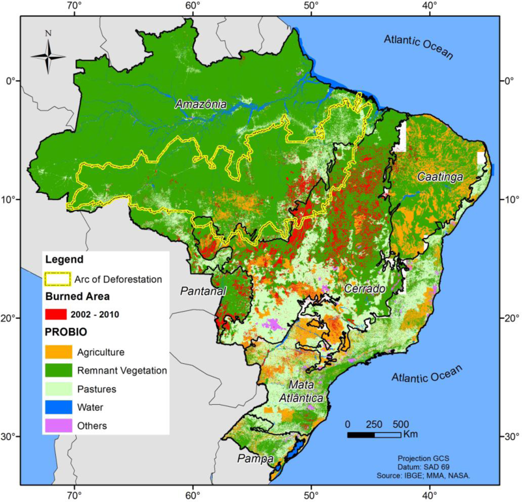
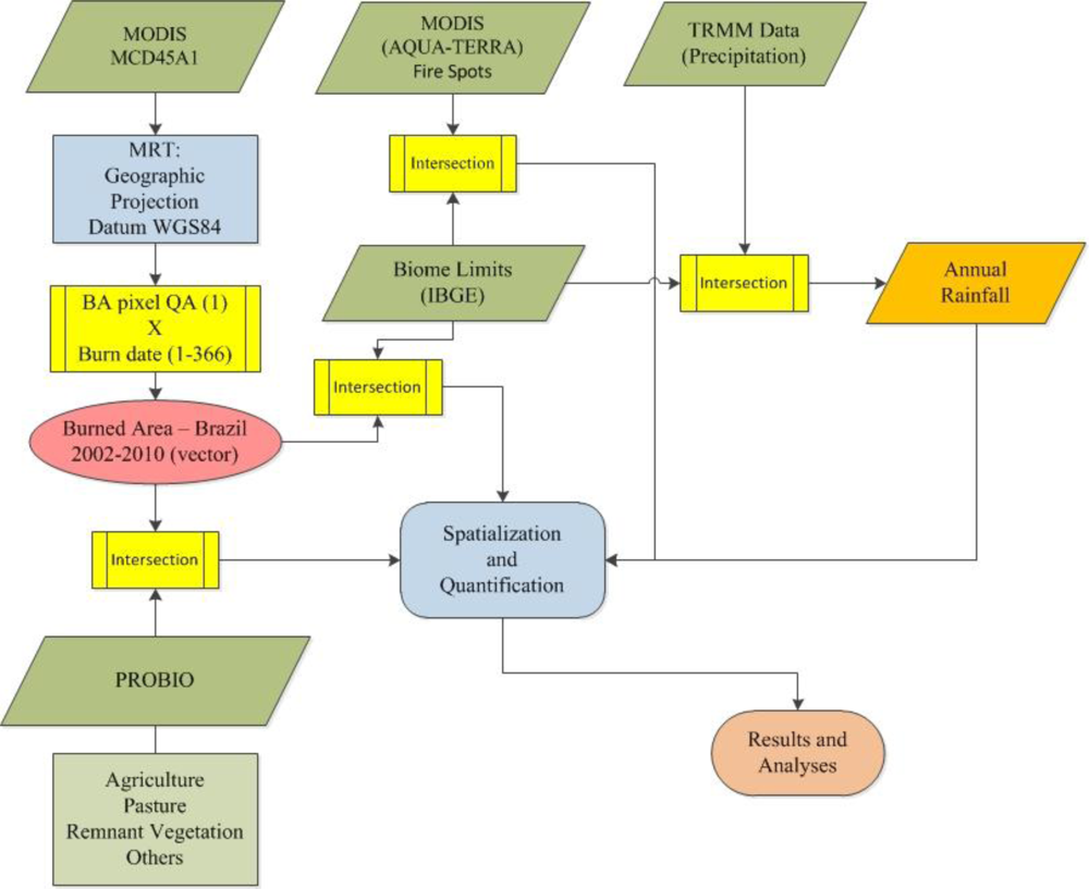
2. Experimental Design
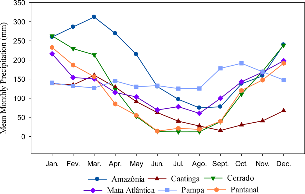
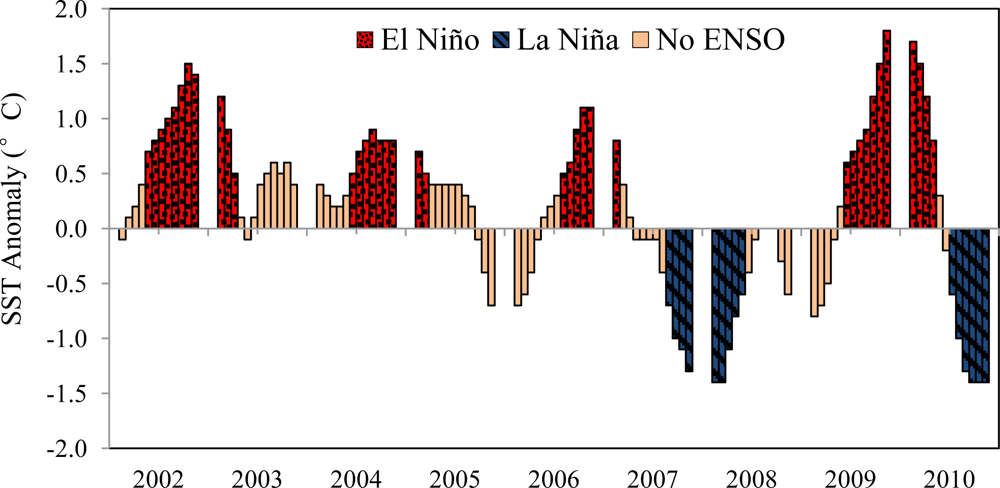
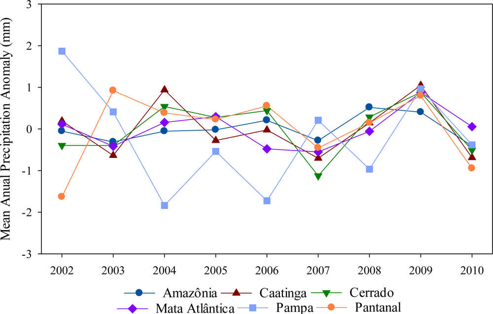
3. Results and Discussion
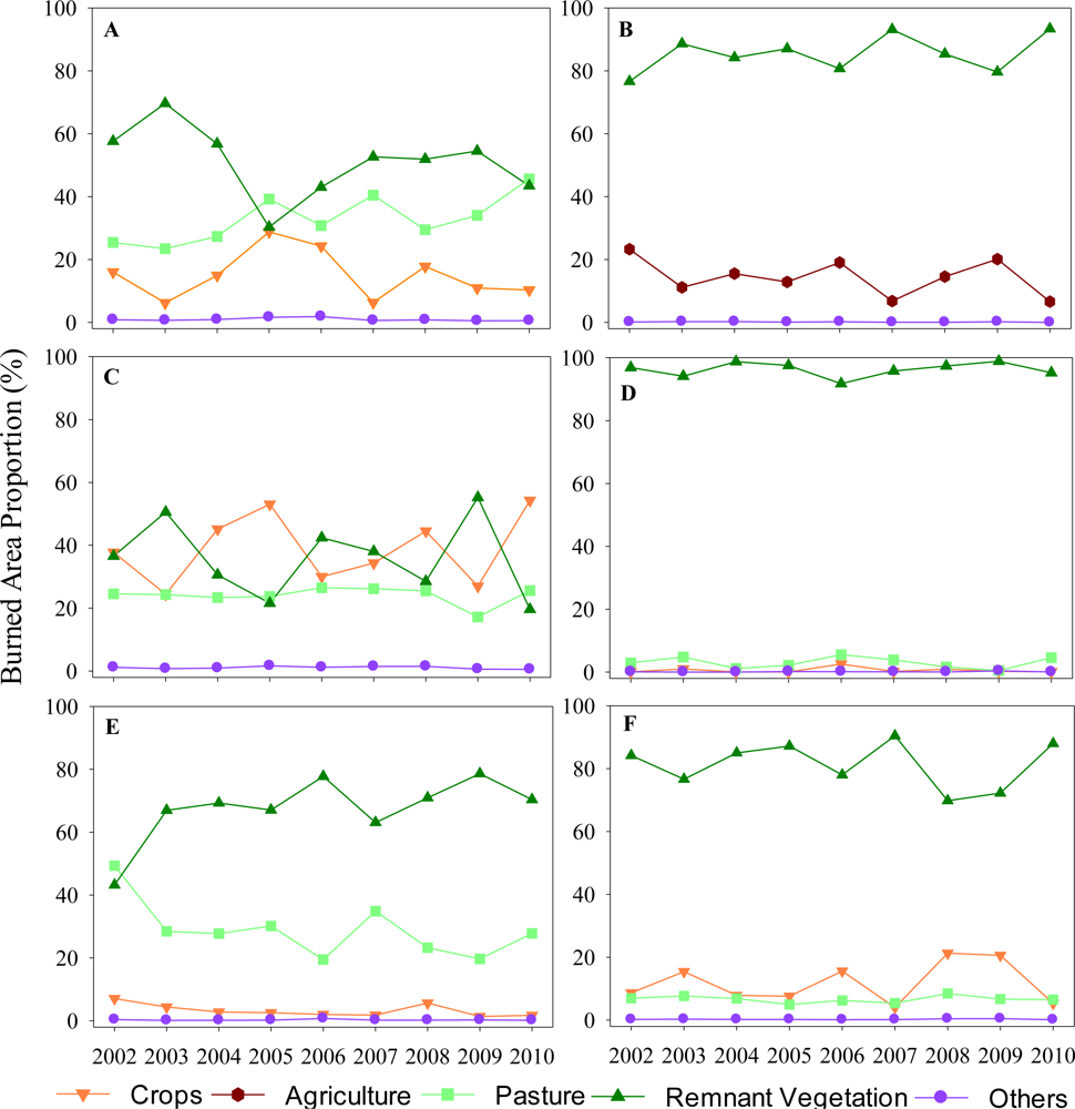
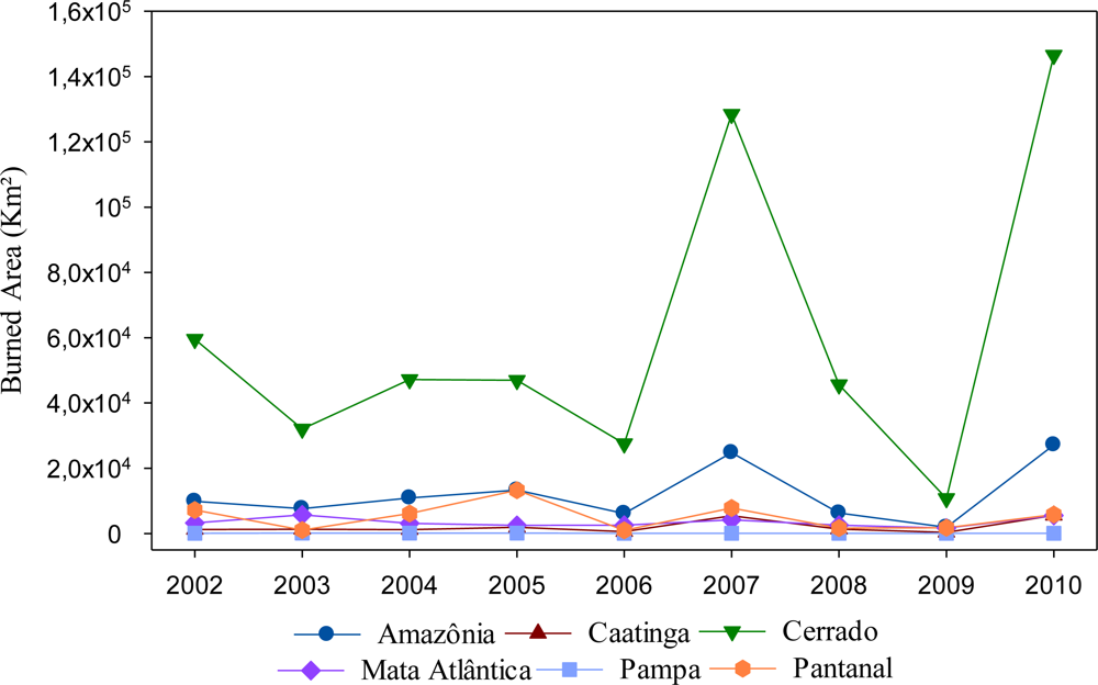
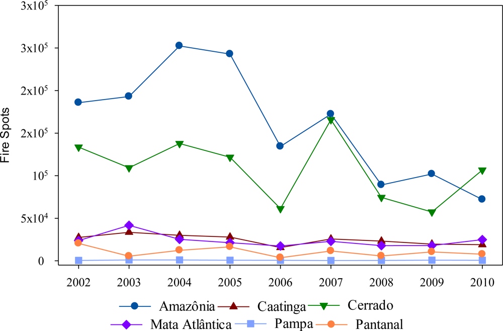
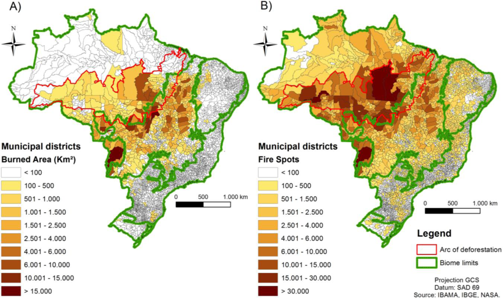
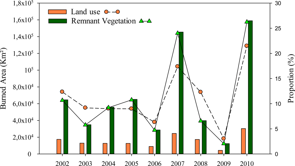
3.1. Burned Areas & Land Cover Classes
4. Concluding Remarks
Acknowledgments
References
- Jin, H. Drivers of Global Wildfires—Statistical Analyses. Ph.D. Dissertation, University of Lund, Lund, Sweden; 2010. [Google Scholar]
- Bond, W.J.; Woodward, F.I.; Midgley, G.F. The global distribution of ecosystems in a world without fire. New Phytol 2005, 165, 525–538. [Google Scholar]
- Van der Werf, G.R.; Randerson, J.T.; Giglio, L.; Collatz, G.J.; Kasibhatla, P.S.; Arellano, A.F.; olsen, S.C.; Kasischke, E.S. Continental-scale partitioning of fire emissions during the 1997 to 2001 El Niño/La Niña period. Science 2004, 303, 73–75. [Google Scholar]
- Bowman, D.M.J.S.; Balch, J.K.; Artaxo, P.; Bond, W.J.; Carlson, J.M.; Cochrane, M.A.; D’Antonio, C.M.; DeFries, R.S.; Doyle, J.C.; Harrison, S.P.; et al. Fire in the earth system. Science 2009, 324, 481–484. [Google Scholar]
- Field, C.B.; Jackson, R.B.; Mooney, H.A. Stomatal responses to increased CO2: Implications from the plant to the global scale. Plant Cell Environ 1995, 18, 1214–1225. [Google Scholar]
- Roderick, M.L.; Farquhar, G.D. The cause of decreased pan evaporation over the past 50 years. Science 2002, 298, 1410–1411. [Google Scholar]
- Ramanathan, V.; Carmichael, G. Global and regional climate changes due to black carbon. Nat. Geosci 2008, 1, 221–227. [Google Scholar]
- Freitas, S.R.; Longo, K.M.; Silva Dias, M.A.F.; Silva Dias, P.L. Emissões de queimadas em ecossistemas da América do Sul. Estud. Avançad 2005, 19, 167–186. [Google Scholar]
- Archibald, S.; Roy, D.P.; van Wilgen, B.W.; Scholes, R.J. What limits fire? An examination of drivers of burnt area in Southern Africa. Glob. Change Biol 2009, 15, 613–630. [Google Scholar]
- Mims, F.M., 3rd. Health effects of tropical smoke. Nature 1997, 390, 222–223. [Google Scholar]
- Kunii, O. Health Guidelines for Vegetation Fire Events: Background Papers; Goh, K., Schwela, D., Goldammer, J.G., Simpson, O., Eds.; World Heath Organ: Geneva, Switzerland; p. 1999.
- Ribeiro, H.; Assunção, J.V. Efeitos das queimadas na saúde humana. Estud. Avançad 2002, 16, 125–148. [Google Scholar]
- Cançado, J.E.D. A poluição Atmosférica e sua Relação com a Saúde Humana na Região Canavieira de Piracicaba—SP. Ph.D. Dissertation, Faculdade de Medicinada/USP, São Paulo, Brazil; 2003. [Google Scholar]
- Arbex, M.A.; Cançado, J.E.D.; Pereira, L.A.A.; Braga, A.L.; Saldiva, P.H.N. Queima de biomassa e efeitos sobre a saúde. J. Bras. Pneumol 2004, 30, 158–175. [Google Scholar]
- Mascarenhas, M.D.; Vieira, L.C.; Lanzieri, T.M.; Leal, A.p.; Duarte, A.F.; Hacth, D.L. Anthropogenic air pollution and respiratory disease-related emergency room visits in Rio Branco, Brazil—September, 2005. J. Bras. Pneumol 2008, 34, 42–46. [Google Scholar]
- Mendonça, M.J.C.; Vera Diaz, M.D.C.; Daniel, D.C.; Seroa, R.; Alencar, A.; Gomes, J.C.; Ortiz, R.A. The economic cost of the use of fire in the Brazilian Amazon. Ecol. Econ 2004, 49, 89–105. [Google Scholar]
- Ribeiro, H. Queimadas de cana-de-açúcar no Brasil: Efeitos à saúde respiratória. Rev. Saúde Pub 2008, 42, 370–376. [Google Scholar]
- Roy, D.P.; Boschetti, L.; Justice, C.O.; Ju, J. The collection 5 MODIS burned area product—Global evaluation by comparison with the MODIS active fire product. Remote Sens. Environ 2008, 112, 3690–3707. [Google Scholar]
- Chang, D.; Song, Y. Comparison of L3HRC and MODIS global burned area products from 2000 to 2007. J. Geoph. Res 2009, 114. [Google Scholar] [CrossRef]
- Bella, C.M.; Jobbágy, E.G.; Paruelo, J.M.; Pinnock, S. Continental fire density patterns in South America. Glob. Ecol. Biogeogr 2006, 15, 192–199. [Google Scholar]
- Uhl, C.; Kauffman, J.B. Deforestation, fire susceptibility, and potential tree responses to fire in Eastern Amazon. Ecology 1990, 71, 437–449. [Google Scholar]
- Ratter, J.A. Transitions between Cerrado and Forest Vegetation in Brazil. In Nature and Dynamics of Forest-Savanna Boundaries; Chapman and Hall: New York, NY, USA, 1992; p. 616. [Google Scholar]
- Kauffman, J.B.; Sanford, JR.; Cummings, D.L.; Salcedo, I.H.; Sampaio, E.V.S.B. Biomass and nutrients dynamics associated with slash fires in neotropical dry forests. Ecology 1993, 74, 140–151. [Google Scholar]
- Ratter, J.A.; Ribeiro, J.F.; Bridgewater, S. The brazilian cerrado vegetation and threats to its biodiversity. Ann. Bot 1997, 80, 223–230. [Google Scholar]
- Silva, F.A.M.; Assad, E.D.; Evangelista, B.A. Caracterização Climática do Bioma Cerrado. In Cerrado: Ecologia e Flora, 1st ed.; Sano, S.M., Almeida, S.P., Ribeiro, J.F., Eds.; Embrapa Informação Tecnológica: Brasília, Brazil, 2008; pp. 69–88. [Google Scholar]
- França, H.; Setzer, A.W. AVHRR analysis of a savana site through a fire season in Brazil. Int. J. Remote Sens 2001, 22, 2449–2461. [Google Scholar]
- Coutinho, L.M. O conceito de bioma. Acta Bot. Braz 2006, 20, 13–23. [Google Scholar]
- Klink, A.C.; Machado, R.B. A conservação do Cerrado brasileiro. Megadiversidade 2005, 1, 147–155. [Google Scholar]
- Certini, G. Effects of fire on properties of forest soils: A review. Oecologia 2005, 143. [Google Scholar] [CrossRef]
- Ministério do Meio Ambiente/SBF, Mapeamento da Cobertura Vegetal do Bioma Cerrado, Relatório Final, Edital Probio 02/2004; Projeto Executivo B.02.02.109, Brasília, Brazil. 2007.
- Rivera-Lombardi, R.J. Estimativa de Áreas Queimadas com Produtos MODIS como Subsídio à Estimativa de Emissões de Gases de Efeito Estufa pela Queima de Biomassa na Amazônia e Cerrado Brasileiros. Ph.D. Dissertation, Instituto Nacional de Pesquisas Espaciais (INPE), São José dos Campos, Brazil. 2009. [Google Scholar]
- Boschetti, L.; Roy, D.; Hoffmann, A.A. MODIS Collection 5 Burned Area Product—MCD45 User’s Guide; Version 2.0; University of Maryland: College Park, MD, USA, 2009. [Google Scholar]
- United States Geological Survey (USGS). MODIS Reprojection Tool V4.1. 2011. Available online: http://lpdaac.usgs.gov/lpdaac/tools/ (accessed on 28 June 2011).
- Boschetti, L.; Roy, D.; Barbosa, P.; Boca, R.; Justice, C. A MODIS assessment of the summer 2007 extent burned in Greece. Int. J. Remote Sens 2008, 29, 2433–2436. [Google Scholar]
- Roy, D.P.; Boschetti, L. Southern Africa Validation of the MODIS, L3JRC and GlobCarbon Burned Area Products. IEEE Trans. Geosci. Remote Sens 2009, 47, 1032–1044. [Google Scholar]
- Justice, C.O.; Giglio, L.; Boschetti, L.; Roy, D.P.; Csiszar, I.; Morisette, J.; Kaufman, Y. MODIS Fire Products—Algorithm Technical Background Document, Version 2.3. October 2006. Available online: http://modis.gsfc.nasa.gov/data/atbd/atbd_mod14.pdf (accessed on 17 January 2012).
- Kummerow, C.; Simpson, J.; Thiele, O.; Barnes, W.; Chang, A.T.C.; Stocker, E.; Adler, R.F.; Hou, A.; Kakar, R.; Wentz, F.; et al. The status of the tropical rainfall measuring mission (TRMM) after two years in orbit. J. Appl. Meteorol 2000, 39, 1965–1982. [Google Scholar]
- NASA. Monthly 0.25 × 0.25 TRMM and Other Sources Rainfall; NASA Distributed Active Archive Center, Goddard Space Flight Center Earth Science: Greenbelt, MD, USA, 2009. Available online: http://disc.sci.gsfc.nasa.gov/precipitation/ (accessed on 20 December 2011).
- Armenteras-Pascual, D.; Retana-Alumbreros, J.; Molowny-Horas, R.; Roman-Cuesta, R.M.; Gonzalez-Alonso, F.; Morales-Rivas, M. Characterising fire spatial pattern interactions with climate and vegetation in Colombia. Agric. For. Meteorol 2011, 151, 279–289. [Google Scholar]
- Barbosa, H.A.; Huete, A.R.; Baethgen, W.E. A 20-year study of NDVI variability over the Northeast Region of Brazil. J. Arid Environ 2006, 67, 288–307. [Google Scholar]
- World Metereological Organization. WMO statement on the status of the global climate in 2010. World Meteorol 2011, 1074, 20.
- Cardozo, F.S.; Lima, A.; Pereira, G.; Silva, F.B.; Shimabukuro, Y.E.; Takeda, M.M.G.; Moraes, E.C. Avaliação das Imagens do Produto MCD45 do Sensor MODIS Para a Identificação de Áreas Queimadas. Proceedings of 15th Brazilian Symposium on Remote Sensing (SBSR), Curitiba, Brazil, 30 April–5 May 5 2011; pp. 7942–7949.
- Giglio, L.; Csiszar, I.; Justice, C.O. Global distribution and seasonality of active fires as observed with the Terra and Aqua Moderate Resolution Imaging Spectroradiometer (MODIS) sensors. J. Geom. Phys 2006, 111. [Google Scholar] [CrossRef]
- Giglio, L.; Descloitres, J.; Justice, C.O.; Kaufman, Y.J. An enhanced contextual fire detection algorithm for MODIS. Remote Sens. Environ 2003, 87, 273–282. [Google Scholar]
- NOAA’s El Nino Page. February 2012. Available online: http://www.elnino.noaa.gov/ (accessed on 15 February 2012).
- Marengo, J.A.; Oliveira, G.S. Impactos do Fenômeno La Nina no Tempo e Clima do Brasil: Desenvolvimento e Intensificação do La Nina 1998/1999. Proceedings of 10th Brazilian Congresso of Meteorology, Brasilia, Brazil, October 1998. [CD-ROM].
- Marengo, J.A.; Nobre, C.A.; Tomasella, J. The Drought of Amazonia in 2005. Am. Meteorol. Soc 2008, 21, 1–6. [Google Scholar]
- Malhi, Y.; Roberts, J.T.; Betts, R.A.; Killeen, T.J.; Nobre, C.A. Climate change, deforestation and the fate of the Amazon. Science 2008, 19, 169–172. [Google Scholar]
- Lewis, S.L.; Brando, P.M.; Phillips, O.L.; van der Heijden, G.M.F.; Nepstad, D. The 2010 Amazon drought. Science 2011, 331. [Google Scholar] [CrossRef]
- Miranda, H.S.; Sato, M.N.; Andrade, S.M.A.; Harudasan, M.; Morais, H.C. Queimadas de Cerrado: Caracterização e Impactos. In Cerrado: Ecologia e Caracterização; Aguiar, L.M.S., Camargo, A.J.A., Eds.; Embrapa Cerrados: Planaltina, Brazil, 2004; pp. 69–123. [Google Scholar]
- Ayoade, J.O. Introdução a Climatologia Para os Trópicos, 9th ed.; Rio de Janeiro: Bertrand, Brazil, 2003; p. 322. [Google Scholar]
- Mendonça, F.; Danni-Oliveira, I.M. Climatologia: Noções Básicas e Climas do Brasil, 1st ed; Oficina de textos: São Paulo, Brazil, 2007; p. 208. [Google Scholar]
- Uhl, C.; Buschbacher, R.; Serrão, E.A.S. Abandoned pastures in Eastern Amazonia. I. Patterns of plant succession. J. Ecol 1988, 76, 663–681. [Google Scholar]
- Kauffman, J.B; Cummings, D. L; Ward, D.E. Fire in the Brazilian Amazon 2. Biomass, nutrient pools, and losses in cattle pastures. Oecologia 1998, 113, 415–427. [Google Scholar]
- Davidson, E.A.; Neill, C.; Krusch, A.V.; Ballester, V.V.R.; Markewitz, D.; Figueiredo, R.O. Loss of Nutrients from Terrestrial Ecosystems to Streams and the Atmosphere Following Land Use Change in Amazonia. In Ecosystems and Land Use Change; DeFries, R., Asner, G., Houghton, R., Eds.; American Geophysical Union: Washington, DC, USA, 2004; pp. 147–158. [Google Scholar]
- Krug, T.; Rivera-Lombardi, R.J.; Dos Santos, J.R. Burned area, Recurrence of Fires and Permanence of Burnt scars in Selected Areas of the Brazilian Cerrado Using TM-Landsat Imagery. Proceedings of the XXth ISPRS Congress: Geo-Imagery Bridging Continents, Istanbul, Turkey, 12–23 July 2004; pp. 243–246.
- Ramos-Neto, M.B.; Pivello, V.R. Lightning fires in a Brazilian savanna National Park: Rethinking management strategies. Environ. Manag 2000, 26, 675–684. [Google Scholar]
- Pivello, V.R. Fire Management for Biological Conservation in the Brazilian Cerrado. In Savana and Dry Forests—Linking People with Nature; Mistry, J., Berardi, A., Eds.; Ashgate: Farnham, UK, 2006; pp. 129–154. [Google Scholar]
- Morton, D.C. Changes in Amazon Forest Structure from Land-Use Fires: Integrating Satellite Remote Sensing and Ecosystem Modeling. Ph.D. Dissertation, University of Maryland, College Park, MD, USA; 2008. [Google Scholar]
- Cardoso, M.F.; Nobre, C.A.; Sampaio, G.; Hirota, M.; Valeriano, D.; Câmara, G. Long-term potential for tropical-forest degradation due to deforestation and fires in the Brazilian Amazon. Biologia 2009, 64, 433–437. [Google Scholar]
- Ferreira, L.G.; Ferreira, M.E.; Rocha, G.F.; Nemayer, M.; Ferreira, N.C. Dinâmica agrícola e desmatamentos em áreas de Cerrado: Uma analise a partir de dados censitários e imagens de resolução moderada. Rev. Bras. Cartogr 2009, 61, 117–127. [Google Scholar]
- Rocha, G.F.; Ferreira, L.G., JR; Ferreira, N.C.; Ferreira, M.E. Detecção de desmatamentos no bioma Cerrado entre 2002 e 2009: Padrões, tendências e impactos. Rev. Bras. Cartogr 2011, 63, 341–349. [Google Scholar]
- Diniz-Filho, J.A.F.; Oliveira, G.; Lobo, F.; Ferreira, L.G., Jr.; Bini, L.M.; Rangel, T.F.V.L.B. Agriculture, habitat loss and spatial patterns of human occupation in a biodiversity hotspot. Sci. Agric 2009, 66, 764–771. [Google Scholar]
- Jepson, W. A disappearing biome? Reconsidering land cover change in the Brazilian savanna. Geogr. J 2005, 17, 99–111. [Google Scholar]
- Pivello, V.R.; Coutinho, L.M. Tranfer of macro-nutrients to the atmosphere during experimental burnings in a open cerrado (Brasilian savanna). J. Trop. Ecol 1992, 8, 457–497. [Google Scholar]
- Pivello, V.R.; Coutinho, L.M. A qualitative successional model to assist in the management of Brazilian cerrados. For. Ecol. Manag 1996, 87, 127–138. [Google Scholar]
- Nepstad, D.C.; Moreira, A.G.; Alencar, A.A. Floresta em Chamas: Origens, Impactos e Prevenção do Fogo na Amazônia; Programa Piloto para Proteção das Florestas Tropicais do Brasil: Brasília, Brasil, 1999; p. 202. [Google Scholar]
- Morton, D.C.; Shimabukuro, Y.E.; Rudorff, B.F.T.; Lima, A.; Freitas, R.M.; DeFries, R.S. Conservation challenge at the agricultural frontier: Deforestation, fire, and land use dynamics in Mato Grosso. Ambi-Agua 2007, 2, 5–20. [Google Scholar]
- Ferreira, L.V.; Venticinque, E.; Almeida, S. O desmatamento na Amazônia e a importância das áreas protegidas. Estud. Avançad 2005, 19, 1–10. [Google Scholar]
- Fearnside, P.M. Desmatamento na Amazônia brasileira: História, índices e conseqüências. Megadiversidade 2005, 1, 113–123. [Google Scholar]
- Nogueira, E.M.; Fearnside, M.; Nelson, B.W.; Franca, M.B. Wood density in forests of Brazil’s “arc of deforestation”: Implications for biomass and flux of carbon from land-use change in Amazonia. For. Ecol. Manag 2007, 248, 119–135. [Google Scholar]
- Silvestrini, R.A.; Soares-Filho, B.S.; Nepstad, D.; Coe, M.; Rodrigues, H.O.; Assunção, R. Simulating fire regimes in the Amazon in response to climate change and deforestation. Ecol. Appl 2011, 21, 1573–1590. [Google Scholar]
- Costa, M.H.; Pires, G.F. Effects of Amazon and Central Brazil deforestation scenarios on the duration of the dry season in the arc of deforestation. Int. J. Climatol 2010, 30, 1970–1979. [Google Scholar]
- Lara, L.L.; Artaxo, P.; Martinelli, L.A.; Victoria, R.L.; Ferraz, E.S.B. Properties of aerosols from sugar-cane burning emissions in Southeastern Brazil. Atmos. Environ 2005, 39, 4627–4637. [Google Scholar]
- Carvalho, J.L.N.; Avanzi, J.C.; Silva, M.L.N.; Mello, C.R.; Cerri, C.E.P. Potencial de sequestro de carbono em diferentes biomas do Brasil. Rev. Bras. Ciênc. Solo 2010, 34, 277–289. [Google Scholar]
- Ribeiro, H.; Ficarelli, T.R.A. Queimadas nos canaviais e perspectivas dos cortadores de cana-de-açúcar em Macatuba, São Paulo. Saúde Soc 2010, 19, 48–63. [Google Scholar] [Green Version]
- Rudorff, B.F.T.; Aguiar, D.A.; Silva, W.F.; Sugawara, L.M.; Adami, M.; Moreira, M.A. Studies on the rapid expansion of sugarcane fo ethanol production in São Paulo (Brazil) using Landsat data. Remote Sens 2010, 2, 1057–1076. [Google Scholar]
- Aguiar, D.A.; Silva, W.F.; Rudorff, B.F.T.; Adami, M. CANASAT Project: Monitoring the Sugarcane Harvest Type in the State of São Paulo, Brazil. Proceedings of the International Archives of the Photogrammetry, Remote Sensing and Spatial Information Sciences (ISPRS) TC VII Symposium—100 Years ISPRS, Vienna, Austria, 5–7 July 2010; 38, pp. 10–15.


| Biomes | 2002 | 2003 | 2004 | 2005 | 2006 | 2007 | 2008 | 2009 | 2010 | Total |
|---|---|---|---|---|---|---|---|---|---|---|
| Amazon | 10 | 8 | 11 | 13 | 6 | 25 | 6 | 2 | 27 | 108 |
| Caatinga | 1 | 1 | 1 | 2 | 0.6 | 5 | 1 | 0.4 | 4 | 17 |
| Cerrado | 60 | 32 | 47 | 47 | 28 | 129 | 46 | 11 | 147 | 545 |
| Atlantic Forest | 3 | 5 | 3 | 2 | 2 | 4 | 2 | 1 | 5 | 27 |
| Pampa | 0.3 | 0.7 | 0.4 | 0.2 | 0.2 | 0.5 | 0.2 | 0.3 | 0.4 | 3 |
| Pantanal | 8 | 1 | 6 | 14 | 1 | 8 | 2 | 2 | 6 | 48 |
| Total | 82 | 48 | 69 | 78 | 38 | 170 | 57 | 17 | 189 | 748 |
Share and Cite
Moreira de Araújo, F.; Ferreira, L.G.; Arantes, A.E. Distribution Patterns of Burned Areas in the Brazilian Biomes: An Analysis Based on Satellite Data for the 2002–2010 Period. Remote Sens. 2012, 4, 1929-1946. https://doi.org/10.3390/rs4071929
Moreira de Araújo F, Ferreira LG, Arantes AE. Distribution Patterns of Burned Areas in the Brazilian Biomes: An Analysis Based on Satellite Data for the 2002–2010 Period. Remote Sensing. 2012; 4(7):1929-1946. https://doi.org/10.3390/rs4071929
Chicago/Turabian StyleMoreira de Araújo, Fernando, Laerte Guimarães Ferreira, and Arielle Elias Arantes. 2012. "Distribution Patterns of Burned Areas in the Brazilian Biomes: An Analysis Based on Satellite Data for the 2002–2010 Period" Remote Sensing 4, no. 7: 1929-1946. https://doi.org/10.3390/rs4071929