ICESat/GLAS Data as a Measurement Tool for Peatland Topography and Peat Swamp Forest Biomass in Kalimantan, Indonesia

Abstract
:1. Introduction
2. Methodology
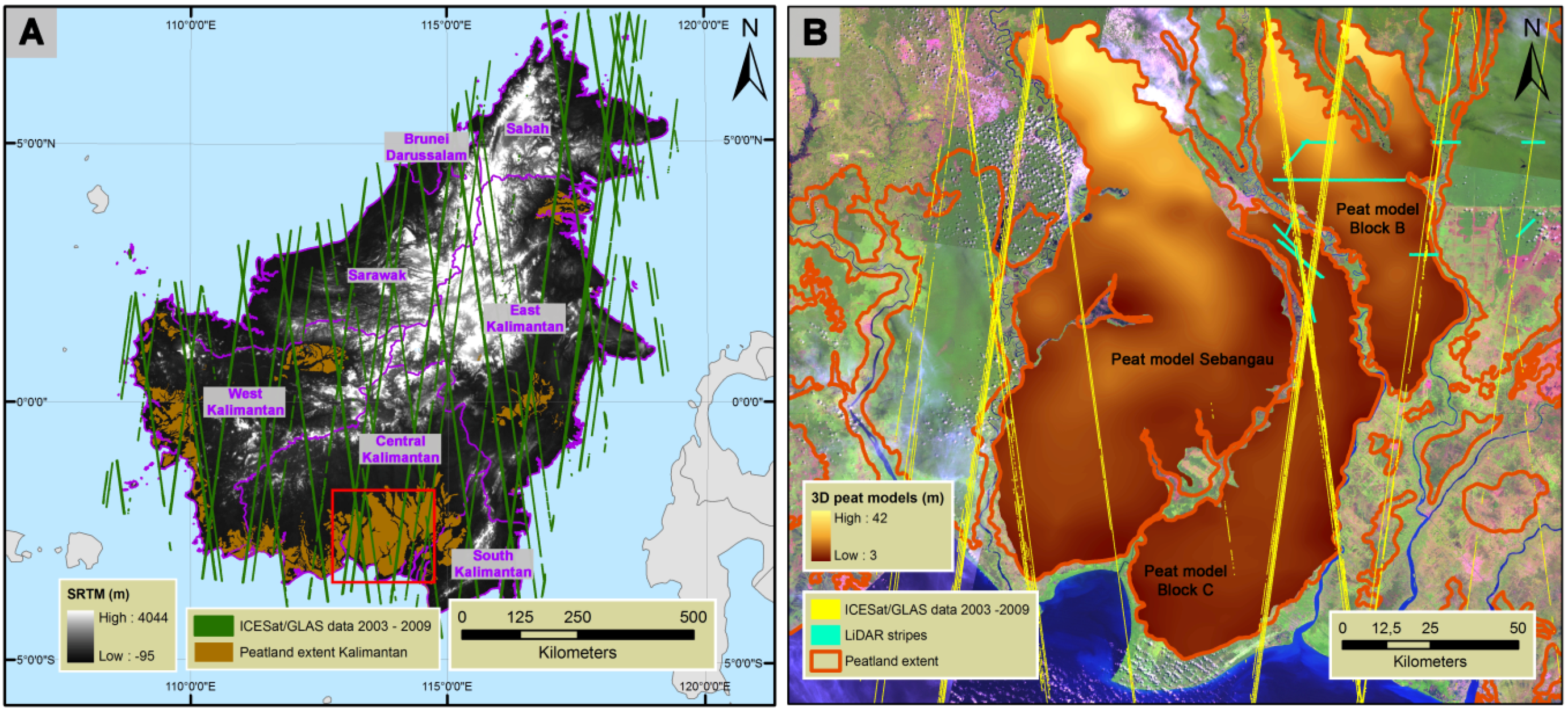
2.1. Study Area
2.2. Data
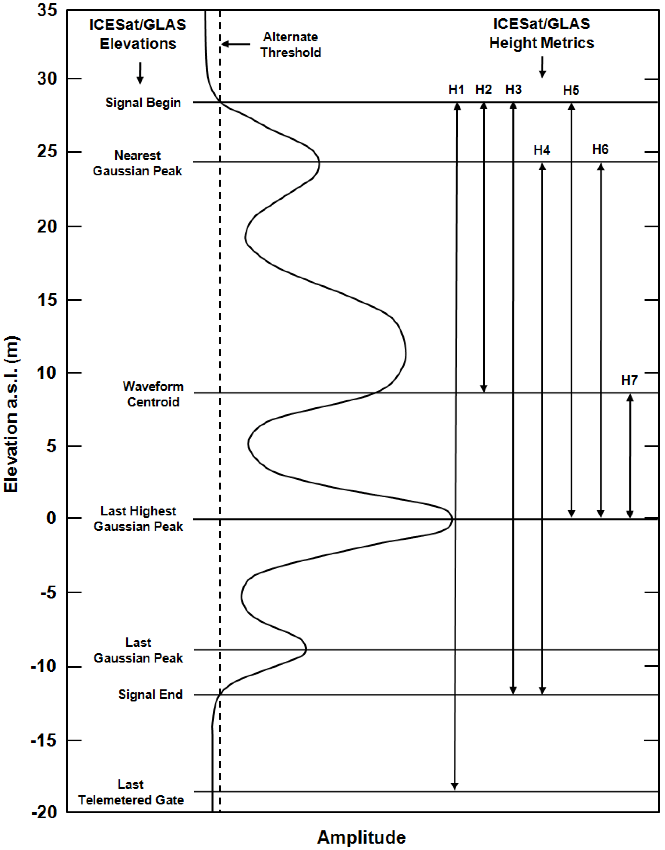
2.2.1. ICESat/GLAS Data

2.2.2. Airborne LiDAR Data
2.2.3. SRTM Data
2.2.4. MODIS Data
2.2.5. Field Inventory Data
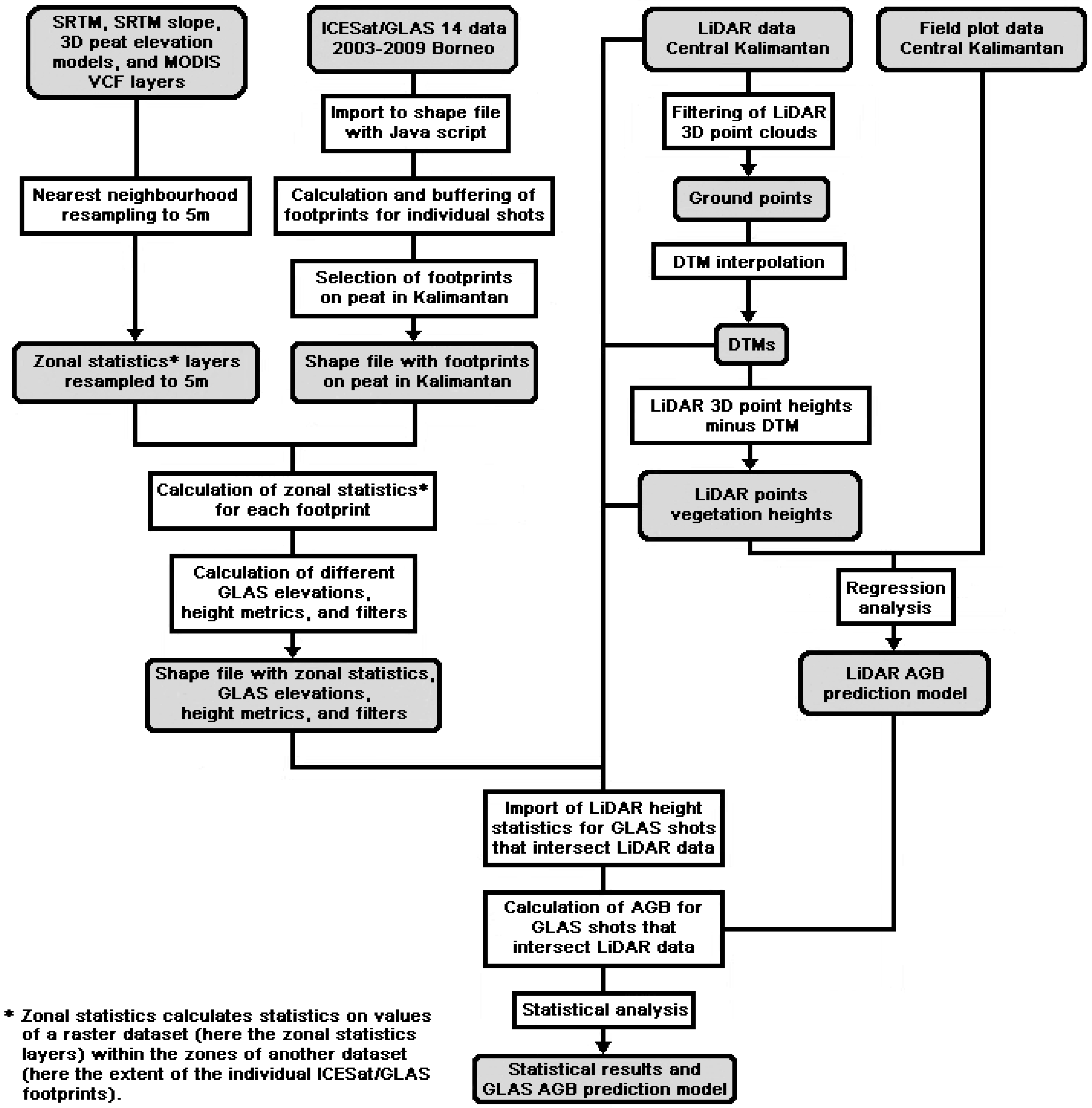
2.3. Data Analysis
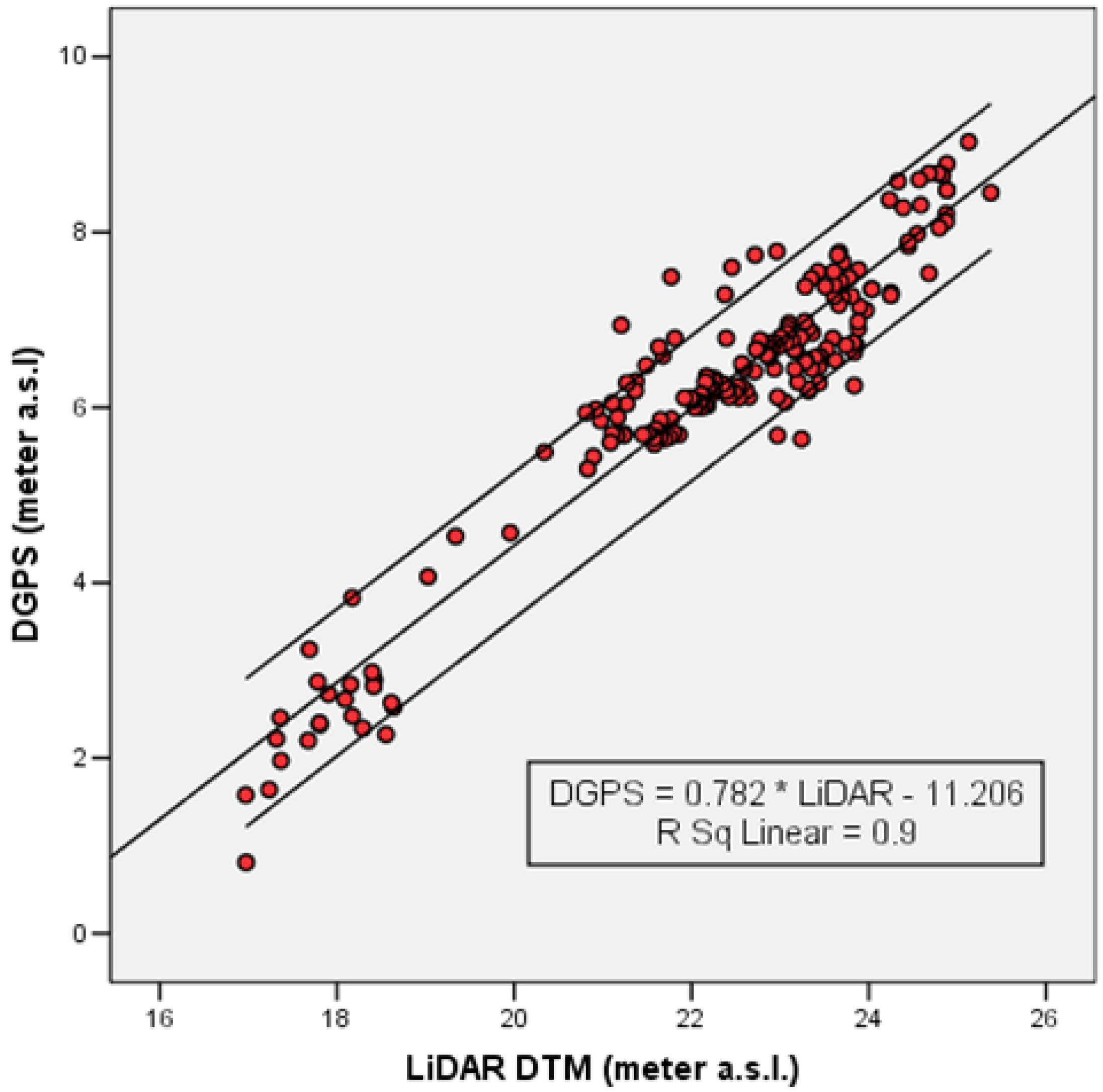
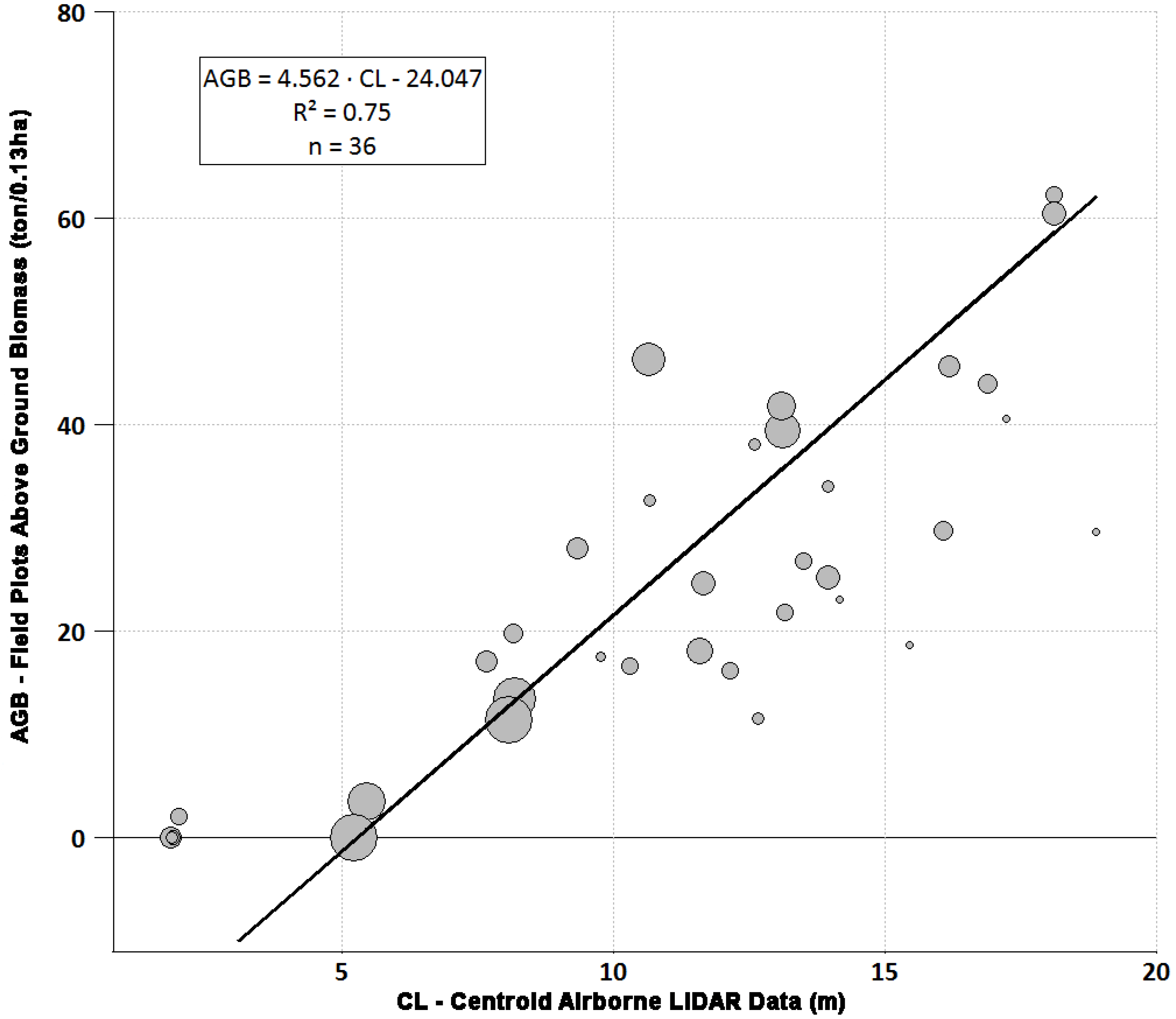
2.3.1. Airborne LiDAR Data Processing and Correlation with Field Inventory Data


2.3.2. ICESat/GLAS Data Processing and Analysis
2.3.3. Comparison ICESat/GLAS and Airborne LiDAR Data
2.3.4. Development of Above Ground Biomass Prediction Models from ICESat/GLAS Data
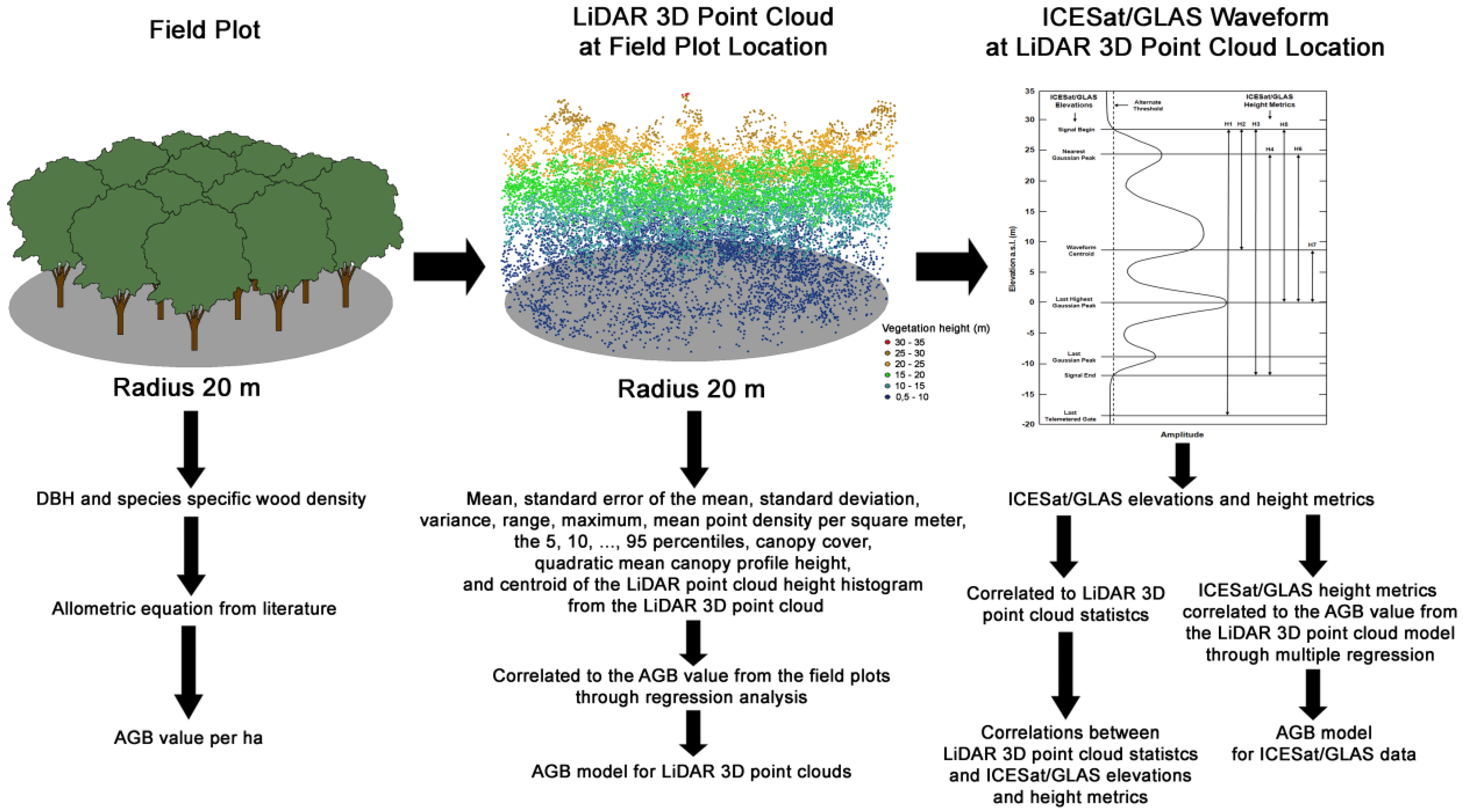
2.3.5. Conceptual Overview

3. Results
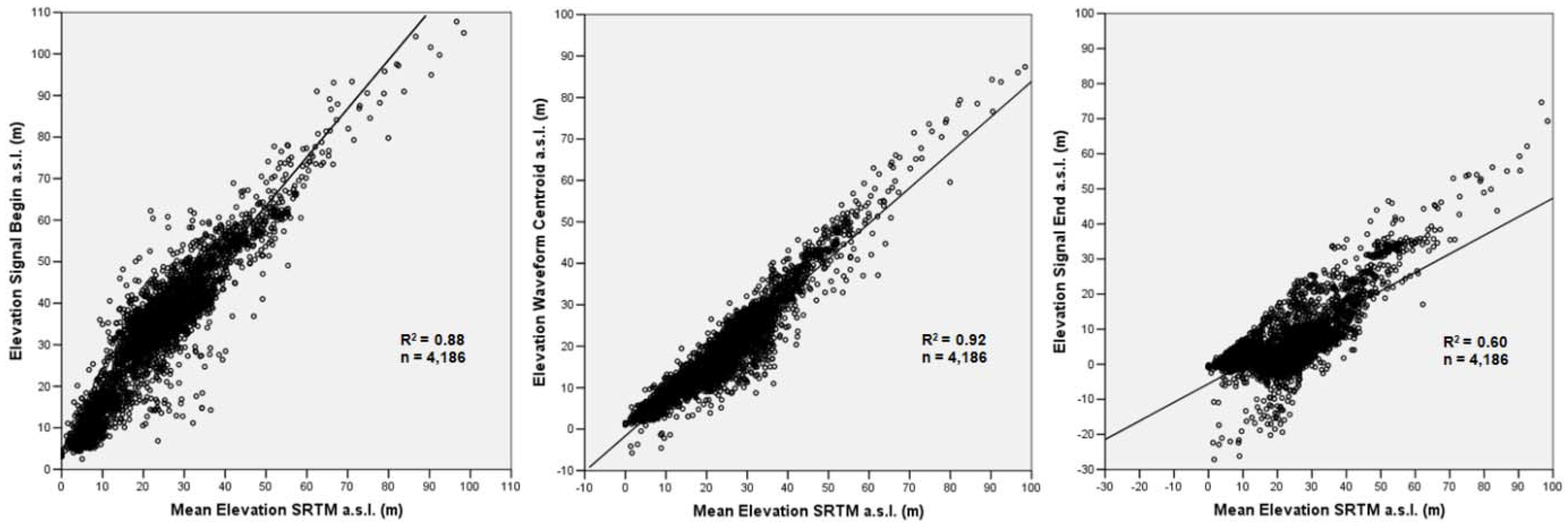
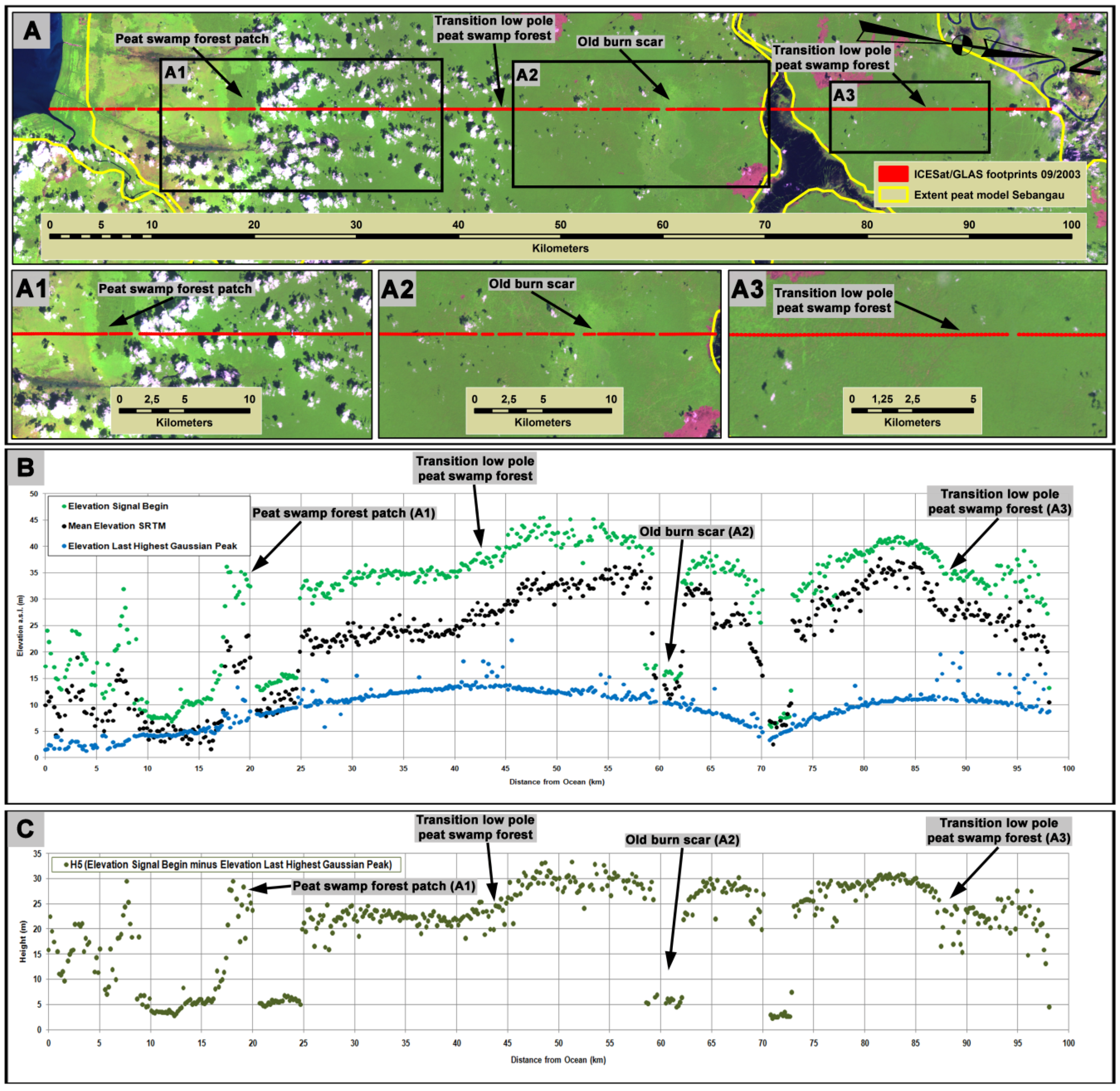
3.1. Comparison ICESat/GLAS, SRTM Data, and SRTM 3D Peatland Elevation Models

3.2. Comparison ICESat/GLAS and Airborne LiDAR Data

| Airborne LiDAR statistics | ICESat/GLAS elevations | ||||||
|---|---|---|---|---|---|---|---|
| n | Signal begin | Nearest Gaussian peak | Waveform centroid | Last highest Gaussian peak | Last Gaussian peak | Signal end | |
| Minimum z | 103 a | 0.50 | 0.48 | 0.61 | 0.63 | 0.68 | 0.66 |
| Maximum z | 103 b | 0.86 | 0.76 | 0.81 | 0.48 | 0.43 | 0.42 |
| Mean z | 104 | 0.84 | 0.77 | 0.91 | 0.60 | 0.60 | 0.59 |
| Minimum DTM | 104 | 0.57 | 0.54 | 0.67 | 0.63 | 0.71 | 0.67 |
| Maximum DTM | 104 | 0.57 | 0.54 | 0.67 | 0.62 | 0.70 | 0.67 |
| Mean DTM | 104 | 0.57 | 0.54 | 0.67 | 0.62 | 0.71 | 0.67 |
| Airborne LiDAR statistics | ICESat/GLAS heights metrics | |||||||
|---|---|---|---|---|---|---|---|---|
| n | H1 | H2 | H3 | H4 | H5 | H6 | H7 | |
| Minimum | 102 a | 0.01 | 0.00 | 0.00 | 0.01 | 0.00 | 0.00 | 0.00 |
| Maximum | 103 b | 0.40 | 0.46 | 0.54 | 0.42 | 0.49 | 0.33 | 0.28 |
| Mean | 104 | 0.26 | 0.22 | 0.36 | 0.30 | 0.34 | 0.25 | 0.29 |
| 5% | 104 | 0.00 | 0.00 | 0.00 | 0.00 | 0.00 | 0.01 | 0.01 |
| 10% | 104 | 0.00 | 0.01 | 0.01 | 0.00 | 0.00 | 0.00 | 0.00 |
| 15% | 104 | 0.00 | 0.01 | 0.02 | 0.01 | 0.00 | 0.00 | 0.00 |
| 20% | 104 | 0.00 | 0.01 | 0.03 | 0.02 | 0.01 | 0.01 | 0.01 |
| 25% | 104 | 0.01 | 0.02 | 0.05 | 0.04 | 0.04 | 0.02 | 0.04 |
| 30% | 104 | 0.03 | 0.03 | 0.09 | 0.07 | 0.07 | 0.04 | 0.08 |
| 35% | 104 | 0.09 | 0.06 | 0.16 | 0.13 | 0.15 | 0.10 | 0.17 |
| 40% | 104 | 0.14 | 0.09 | 0.22 | 0.17 | 0.22 | 0.15 | 0.25 |
| 45% | 104 | 0.18 | 0.11 | 0.25 | 0.19 | 0.24 | 0.16 | 0.26 |
| 50% | 104 | 0.21 | 0.13 | 0.28 | 0.22 | 0.28 | 0.18 | 0.29 |
| 55% | 104 | 0.26 | 0.17 | 0.34 | 0.26 | 0.34 | 0.23 | 0.34 |
| 60% | 104 | 0.29 | 0.20 | 0.38 | 0.30 | 0.38 | 0.26 | 0.36 |
| 65% | 104 | 0.33 | 0.24 | 0.43 | 0.36 | 0.42 | 0.31 | 0.39 |
| 70% | 104 | 0.37 | 0.29 | 0.48 | 0.40 | 0.47 | 0.36 | 0.41 |
| 75% | 104 | 0.40 | 0.33 | 0.51 | 0.44 | 0.51 | 0.40 | 0.42 |
| 80% | 104 | 0.42 | 0.36 | 0.53 | 0.47 | 0.53 | 0.43 | 0.43 |
| 85% | 104 | 0.43 | 0.39 | 0.53 | 0.48 | 0.54 | 0.44 | 0.41 |
| 90% | 104 | 0.42 | 0.41 | 0.53 | 0.49 | 0.53 | 0.44 | 0.38 |
| 95% | 104 | 0.45 | 0.47 | 0.57 | 0.50 | 0.56 | 0.45 | 0.37 |
| 100% | 103 b | 0.40 | 0.46 | 0.54 | 0.42 | 0.49 | 0.33 | 0.28 |
| QMCH | 102 c | 0.27 | 0.23 | 0.40 | 0.35 | 0.39 | 0.34 | 0.31 |
| CL | 104 | 0.28 | 0.21 | 0.38 | 0.32 | 0.37 | 0.35 | 0.28 |
3.3. Above Ground Biomass Prediction Models from Airborne LiDAR Data and ICESat/GLAS Data
| Average LiDAR point densitiy per square m | n | ICESat/GLAS height metrics | ||||||
|---|---|---|---|---|---|---|---|---|
| H1 | H2 | H3 | H4 | H5 | H6 | H7 | ||
| all | 104 | 0.32 | 0.25 | 0.43 | 0.37 | 0.44 | 0.33 | 0.40 |
| ≥0.1 | 93 | 0.40 | 0.31 | 0.51 | 0.43 | 0.52 | 0.40 | 0.46 |
| ≥0.2 | 72 | 0.45 | 0.34 | 0.54 | 0.49 | 0.59 | 0.53 | 0.56 |
| ≥0.3 | 54 | 0.55 | 0.45 | 0.63 | 0.60 | 0.67 | 0.62 | 0.63 |
| ≥0.4 | 47 | 0.65 | 0.55 | 0.69 | 0.66 | 0.70 | 0.63 | 0.67 |
| ≥0.5 | 46 | 0.68 | 0.57 | 0.73 | 0.68 | 0.75 | 0.65 | 0.71 |
| ≥0.6 | 43 | 0.70 | 0.60 | 0.74 | 0.69 | 0.75 | 0.67 | 0.70 |
| ≥0.7 | 41 | 0.72 | 0.62 | 0.75 | 0.71 | 0.77 | 0.70 | 0.70 |
| ≥0.8 | 39 | 0.72 | 0.62 | 0.74 | 0.71 | 0.77 | 0.71 | 0.72 |
| ≥0.9 | 35 | 0.70 | 0.61 | 0.75 | 0.73 | 0.76 | 0.71 | 0.70 |
| ≥1 | 32 | 0.73 | 0.63 | 0.76 | 0.74 | 0.76 | 0.70 | 0.68 |
4. Discussion and Conclusions
Acknowledgments
References
- Page, S.E.; Rieley, J.O.; Banks, C.J. Global and regional importance of the tropical peatland carbon pool. Glob. Chang. Biol. 2010, 17, 798–818. [Google Scholar] [CrossRef]
- Intergovernmental Panel on Climate Change. Climate Change 2007: The Physical Science Basis. Contribution of Working Group I to the Fourth Assessment Report of the Intergovernmental Panel on Climate Change; Solomon, S., Qin, D., Manning, M., Marquis, M., Averyt, K., Tignor, M.M.B., Miller, H.L., Jr., Chen, Z., Eds.; Cambridge University Press: Cambridge, UK, 2007. [Google Scholar]
- Page, S.E.; Rieley, J.O. Tropical peatlands: A review of their natural resource functions with particular reference to Southeast Asia. Int. Peat J. 1998, 8, 95–106. [Google Scholar]
- Sorensen, K.W. Indonesian peat swamp forests and their role as a carbon sink. Chemosphere 1993, 27, 1065–1082. [Google Scholar] [CrossRef]
- Rieley, J.O.; Ahmad-Shah, A.A.; Brady, M.A. The extent and nature of tropical peat swamps. In Tropical Lowland Peatlands of Southeast Asia: Proceedings of a Workshop on Integrated Planning and Management of Tropical Lowland Peatlands held at Cisarua, Indonesia, 3–8 July 1992; Maltby, E., Immirzi, C.P., Safford, R.J., Eds.; IUCN: Gland, Switzerland, 1996; pp. 17–53. [Google Scholar]
- Anderson, J.A.R. Ecosystems of the World 4b-Mires: Swamp, Bog, Fen and Moor; Gore, A.J.P., Ed.; Elsevier: Amsterdam, The Netherlands, 1983; pp. 181–199. [Google Scholar]
- Rieley, J.O.; Page, S.E. Wise Use of Tropical Peatlands: Focus on Southeast Asia; Rieley, J.O., Page, S.E., Eds.; ALTERRA: Wageningen, The Netherlands, 2005. [Google Scholar]
- Page, S.E.; Wuest, R.A.J.; Weiss, D.; Rieley, J.O.; Shotyk, W.; Limin, S.H. A record of Late Pleistocene and Holocene carbon accumulation and climate change from an equatorial peat bog (Kalimantan, Indonesia): Implications for past, present and future carbon dynamics. J. Quat. Sci. 2004, 19, 625–635. [Google Scholar] [CrossRef]
- Hooijer, A.; Page, S.; Canadell, J.G.; Silvius, M.; Kwadijk, J.; Wösten, H.; Jauhiainen, J. Current and future CO2 emissions from drained peatlands in Southeast Asia. Biogeosciences 2010, 7, 1505–1514. [Google Scholar] [CrossRef]
- Jaenicke, J.; Rieley, J.O.; Mott, C.; Kimman, P.; Siegert, F. Determination of the amount of carbon stored in Indonesian peatlands. Geoderma 2008, 147, 151–158. [Google Scholar] [CrossRef]
- Langner, A.; Miettinen, J.; Siegert, F. Land cover change 2002–2005 in Borneo and the role of fire derived from MODIS imagery. Glob. Chang. Biol. 2007, 13, 1–12. [Google Scholar] [CrossRef]
- ADB (Asian Development Bank)/BAPPENAS (National Development Planning Agency). Causes, Extent, Impact and Costs of 1997/98 Fires and Drought Final report, Annex 1 and 2, Planning for Fire Prevention and Drought Management Project; Asian Development Bank TA 2999-INO Fortech; Pusat Pengembangan Agribisnis, Margueles Pöyry: Jakarta, Indonesia, 1999. [Google Scholar]
- Bompard, J.M.; Guizol, P. Land Management in South Sumatra Province, Indonesia. Fanning the Flames: The Institutional Cause of Vegetation Fires; European Union Forest Fire Prevention and Control Project and Indonesian Ministry of Forestry and Estate Crops: Jakarta, Indonesia, 1999. [Google Scholar]
- Bowen, M.R.; Bompard, J.M.; Anderson, I.P.; Guizol, P.; Gouvon, A. Forest Fires and Regional Haze in Southeast Asia; Eaton, P., Radojevic, M., Eds.; Nova Science: New York, NY, USA, 2000; pp. 52–66. [Google Scholar]
- Siegert, F.; Rücker, G.; Hinrichs, A.; Hoffmann, A. Increased fire impacts in logged over forests during El Niño driven fires. Nature 2001, 414, 437–440. [Google Scholar] [CrossRef] [PubMed]
- Langner, A.; Siegert, F. Spatiotemporal fire occurrence in Borneo over a period of 10 years. Glob. Chang. Biol. 2009, 15, 48–62. [Google Scholar] [CrossRef]
- Ballhorn, U.; Siegert, F.; Mason, M.; Limin, S. Derivation of burn scar depths and estimation of carbon emissions with LIDAR in Indonesian peatlands. Proc. Nat. Acad. Sci. USA 2009, 106, 21213–21218. [Google Scholar] [CrossRef] [PubMed]
- Page, S.E.; Siegert, F.; Rieley, J.O.; Boehm, H.-D.V.; Jaya, A.; Limin, S. The amount of carbon released from peatland forest fires in Indonesia during 1997. Nature 2002, 420, 61–65. [Google Scholar] [CrossRef] [PubMed]
- Ranson, K.J.; Kimes, D.; Sun, G.; Nelson, R.; Kharuk, V.; Montesano, P. Using MODIS and GLAS Data to Develop Timber Volume Estimates in Central Siberia. In Proceedings of the IEEE International Geoscience and Remote Sensing Symposium, IGARSS 2007, Barcelona, Spain, 23–28 July 2007; pp. 2306–2309.
- Schutz, B.E.; Zwally, H.J.; Shuman, C.A.; Hancock, D.; DiMarzio, J.P. Overview of the ICESat Mission. Geophys. Res. Lett. 2005, 32, L21S01. [Google Scholar] [CrossRef]
- Baccini, A.; Laporte, N.; Goetz, S.J.; Sun, M.; Dong, H. A first map of tropical Africa’s above-ground biomass derived from satellite imagery. Environ. Res. Lett. 2008, 3, 045011. [Google Scholar] [CrossRef]
- Boudreau, J.; Nelson, R.F.; Margolis, H.A.; Beaudoin, A.; Guindon, L.; Kimes, D.S. Regional aboveground forest biomass using airborne and spaceborne LiDAR in Quebec. Remote Sens. Environ. 2008, 112, 3876–3890. [Google Scholar] [CrossRef]
- Dolan, K.A.; Hurtt, G.C.; Chambers, J.Q.; Dubayah, R.O.; Frolking, S.; Masek, J.G. Using ICESat’s Geoscience Laser Altimeter System (GLAS) to assess large-scale forest disturbance caused by hurricane Katrina. Remote Sens. Environ. 2011, 115, 86–96. [Google Scholar] [CrossRef]
- Goetz, S.J.; Sun, M.; Baccini, A.; Beck, P.S.A. Synergistic use of spaceborne lidar and optical imagery for assessing forest disturbance: An Alaska case study. J. Geophys. Res. 2010, 115, G00E07. [Google Scholar] [CrossRef]
- Harding, D.J.; Carajabal, C.C. ICESat waveform measurements of within footprint topographic relief and vegetation vertical structure. Geophys. Res. Lett. 2005, 32, L21S10. [Google Scholar] [CrossRef]
- Lefsky, M.A. A global forest canopy height map from the moderate resolution imaging spectroradiometer and the Geoscience Laser Altimeter System. Geophys. Res. Lett. 2010, 37, L15401. [Google Scholar] [CrossRef]
- Lefsky, M.A.; Keller, M.; Pang, Y.; de Camargo, P.B.; Hunter, M.O. Revised method for forest canopy height estimation from Geoscience Laser Altimeter System waveforms. J. Appl. Remote Sens. 2007, 1, 013537. [Google Scholar]
- Rosette, J.A.B.; North, P.R.J.; Suarez, J.C. Vegetation height estimates for a mixed temperate forest using satellite laser altimetry. Int. J. Remote Sens. 2008, 29, 1475–1493. [Google Scholar] [CrossRef]
- Sun, G.; Ranson, K.J.; Kimes, D.S.; Blair, J.B.; Kovacs, K. Forest vertical structure from GLAS: An evaluation using LVIS and SRTM data. Remote Sens. Environ. 2008, 112, 107–117. [Google Scholar] [CrossRef]
- Page, S.E.; Rieley, J.O.; Shotyk, Ø.W.; Weiss, D. Interdependence of peat and vegetation in a tropical peat swamp forest. Philos. Trans. R. Soc. B Biol. Sci. 1999, 354, 1885–1897. [Google Scholar] [CrossRef] [PubMed]
- MacKinnon, K.; Hatta, G.; Halim, H.; Mangalik, A. The Ecology of Kalimantan—Indonesian Borneo; Periplus Editions (HK) Ltd.: Hong Kong, China, 1996. [Google Scholar]
- Wetlands International. Map of Peatland Distribution Area and Carbon Content in Kalimantan 2000–2002; Wetlands International Indonesian Programme and Wildlife Habitat Canada: Bogor, Indonesia, 2004. [Google Scholar]
- Moeliono, M.; Wollenberg, E.; Limberg, G. The Decentralizaton of Forest Governance: Politics, Economics and the Fight for Control; Earthscan: London, UK, 2009. [Google Scholar]
- The National Snow and Ice Data Center. University of Colorado Boulder: Boulder, CO, USA, 2011. Available online: http://nsidc.org/data/icesat/data.html (accessed on 30 March 2011).
- NSIDC Distributed ICESat GLAS Laser Operations Periods: Latest Release; The National Snow and Ice Data Center, University of Colorado Boulder: Boulder, CO, USA, 2011. Available online: http://nsidc.org/data/icesat/pdf/glas_laser_ops_attrib.pdf (accessed on 18 August 2011).
- Rim, H.J.; Schutz, B.E. Geoscience Laser Altimeter System (GLAS), Precision Orbit Determination (POD). Algorithm Theoretical Basis Documents (ATBD); Version 2.2; Center for Space Research, The University of Texas: Austin, TX, USA, 2002. [Google Scholar]
- Bae, S.; Schutz, B.E. Geoscience Laser Altimeter System (GLAS), Precision Attitude Determination (PAD). Algorithm Theoretical Basis Documents (ATBD); Version 2.2; Center for Space Research, The University of Texas: Austin, TX, USA, 2002. [Google Scholar]
- Schutz, B.E. Geoscience Laser Altimeter System (GLAS), Laser Footprint Location (Geolocation) and Surface Profiles. Algorithm Theoretical Basis Documents (ATBD); Version 3.0; Center for Space Research, The University of Texas: Austin, TX, USA, 2002. [Google Scholar]
- Brenner, A.C.; Zwally, H.J.; Bentley, C.R.; Csatho, B.M.; Harding, D.J.; Hofton, M.A.; Minster, J.B.; Roberts, L.A.; Saba, J.L.; Thomas, R.H.; Yi, D. Geoscience Laser Altimeter System (GLAS), Derivation of Range and Range Distributions from Laser Pulse Waveform Analysis for Surface Elevations, Roughness, Slope, and Vegetations Heights. Algorithm Theoretical Basis Documents (ATBD); Version 4.1; Center for Space Research, The University of Texas: Austin, TX, USA, 2003. [Google Scholar]
- Ranson, K.J.; Sun, G.; Kovacs, K.; Kharuk, V.I. Landcover Attributes from ICESat GLAS Data in Central Siberia. In Proceedings of the IEEE International Geoscience and Remote Sensing Symposium, IGARSS 2004, Anchorage, AK, USA, 20–24 September 2004; Volume 2, pp. 753–756.
- Ranson, K.J.; Sun, G.; Kovacs, K.; Kharuk, V.I. Use of ICESat GLAS Data for Forest Disturbance Studies in Central Siberia. In Proceedings of the IEEE International Geoscience and Remote Sensing Symposium, IGARSS 2004, Anchorage, AK, USA, 20–24 September 2004; Volume 3, pp. 1936–1939.
- Lefsky, M.A.; Harding, D.J.; Keller, M.; Cohen, W.B.; Carabajal, C.C.; Del Bom Espirito-Santo, F.; Hunter, M.O.; de Oliveira, R., Jr. Estimates of forest canopy height and aboveground biomass using ICESat. Geophys. Res. Lett. 2005, 32, L22S02. [Google Scholar] [CrossRef]
- Lillesand, T.M.; Kiefer, R.W.; Chipman, J.W. Remote Sensing and Image Interpretation; John Wiley & Sons Inc.: Hoboken, NJ, USA, 2008. [Google Scholar]
- Hansen, M.C.; DeFries, R.S.; Townshend, J.R.G.; Carroll, M.; Dimiceli, C.; Sohlberg, R.A. Global percent tree cover at a spatial resolution of 500 meters: First results of the MODIS Vegetation Continuous Fields Algorithm. Earth Int. 2003, 7, 1–15. [Google Scholar] [CrossRef]
- Pearson, T.; Walker, S.; Brown, S. Sourcebook for Land Use, Land-Use Change and Forestry Projects; Winrock International: Little Rock, AR, USA, 2005. [Google Scholar]
- Chudnoff, M. Tropical Timbers of the World; Agriculture Handbook 607; US Department of Agriculture, Forest Service, Forest Products Laboratory: Madison, WI, USA, 1984.
- Wood Density Database; World Agroforestry Centre: Noirobi, Kenya, 2011; Available online: http://www.worldagroforestrycentre.org/Sea/Products/AFDbases/WD/Index.htm (accessed on 30 March 2011).
- Intergovernmental Panel on Climate Change. 2006 IPCC Guidelines for National Greenhouse Gas Inventories; Eggleston, H.S., Buendia, L., Miwa, K., Ngara, T., Tanabe, K., Eds.; Prepared by the National Greenhouse Gas Inventories Programme; IGES: Hayama, Japan, 2006. [Google Scholar]
- Brown, S. Estimating biomass and biomass change of tropical forests: A primer. FAO For. Pap. 1997, 134, 1–84. [Google Scholar]
- Chave, J.; Andalo, C.; Brown, S.; Cairns, M.A.; Chambers, J.Q.; Eamus, D.; Fölster, H.; Fromard, F.; Higuchi, N.; Kira, T.; Lescure, J.-P.; Nelson, B.W.; Ogawa, H.; Puig, H.; Riera, B.; Yamakura, T. Tree allometry and improved estimation of carbon stocks and balance in tropical forests. Oecologica 2005, 145, 87–99. [Google Scholar] [CrossRef] [PubMed]
- Kraus, K.; Pfeifer, N. Determination of terrain models in wooded areas with airborne laser scanner data. ISPRS J. Photogramm. 1998, 53, 193–203. [Google Scholar] [CrossRef]
- Lefsky, M.A.; Cohen, W.B.; Harding, D.J.; Parkers, G.G.; Acker, S.A.; Gower, S.T. Lidar remote sensing of above-ground biomass in three biomes. Glob. Ecol. Biogeogr. 2002, 11, 393–399. [Google Scholar] [CrossRef]
- Carabajal, C.C.; Harding, D.J. SRTM C-band and ICESat laser altimetry elevation comparisons as a function of tree cover and relief. Photogramm. Eng. Remote Sensing 2006, 72, 287–298. [Google Scholar] [CrossRef]
- Waldes, N.J.L.; Page, S.E. Forest Structure and Tree Diversity of A Peat Swamp Forest in Central Kalimantan, Indonesia. In Proceedings of the International Symposium on Tropical Peatlands, Jakarta, Indonesia, 22–23 August 2001; pp. 16–22.
- Drake, J.B.; Dubayah, R.O.; Clark, D.B.; Knox, R.G.; Blair, J.B.; Hofton, M.A.; Chazdon, R.L.; Weishampel, J.F.; Prince, S.D. Estimation of tropical forest structural characteristics using large-footprint lidar. Remote Sens. Environ. 2002, 79, 305–319. [Google Scholar] [CrossRef]
- Asner, G.P.; Hughes, R.F.; Varga, T.A.; Knapp, D.E.; Kennedy-Bowdoin, T. Environmental and biotic controls over aboveground biomass throughout a tropical rain forest. Ecosystems 2009, 12, 261–278. [Google Scholar] [CrossRef]
- Asner, G.P.; Powell, G.V.N.; Mascaro, J.; Knapp, D.E.; Clark, J.K.; Jacobson, J.; Kennedy-Bowdoina, T.; Balaji, A.; Paez-Acosta, G.; Victoria, E.; Secada, L.; Michael Valqui, M.; Hughes, R.F. High-resolution forest carbon stocks and emissions in the Amazon. Proc. Nat. Acad. Sci. USA 2010, 107, 16738–16742. [Google Scholar] [CrossRef] [PubMed]
- Lucas, R.M.; Cronin, N.; Lee, A.; Moghaddam, M.; Witte, C.; Tickle, P. Empirical relationships between AIRSAR backscatter and LiDAR-derived forest biomass, Queensland, Australia. Remote Sens. Environ. 2006, 100, 407–425. [Google Scholar] [CrossRef]
- Means, J.E.; Acker, S.A.; Harding, D.J.; Blair, J.B.; Lefsky, M.A.; Cohen, W.B.; Harmon, M.E.; McKee, W.A. Use of large-footprint scanning airborne lidar to estimate forest stand characteristics in the Western Cascades of Oregon. Remote Sens. Environ. 1999, 67, 298–308. [Google Scholar] [CrossRef]
© 2011 by the authors; licensee MDPI, Basel, Switzerland. This article is an open access article distributed under the terms and conditions of the Creative Commons Attribution license (http://creativecommons.org/licenses/by/3.0/).
Share and Cite
Ballhorn, U.; Jubanski, J.; Siegert, F. ICESat/GLAS Data as a Measurement Tool for Peatland Topography and Peat Swamp Forest Biomass in Kalimantan, Indonesia. Remote Sens. 2011, 3, 1957-1982. https://doi.org/10.3390/rs3091957
Ballhorn U, Jubanski J, Siegert F. ICESat/GLAS Data as a Measurement Tool for Peatland Topography and Peat Swamp Forest Biomass in Kalimantan, Indonesia. Remote Sensing. 2011; 3(9):1957-1982. https://doi.org/10.3390/rs3091957
Chicago/Turabian StyleBallhorn, Uwe, Juilson Jubanski, and Florian Siegert. 2011. "ICESat/GLAS Data as a Measurement Tool for Peatland Topography and Peat Swamp Forest Biomass in Kalimantan, Indonesia" Remote Sensing 3, no. 9: 1957-1982. https://doi.org/10.3390/rs3091957