Article

Quantitative Assessment of Factors Influencing the Spatiotemporal Variation in Carbon Dioxide Fluxes Simulated by Multi-Source Remote Sensing Data in Tropical Vegetation

1
Key Laboratory of Digital Earth Science, Aerospace Information Research Institute, Chinese Academy of Sciences, Beijing 100094, China
2
The Key Laboratory of Earth Observation of Hainan Province, Hainan Aerospace Information Research Institute, Sanya 572000, China
3
University of Chinese Academy of Sciences, Beijing 100049, China
4
Shenzhen Institute of Advanced Technology, Chinese Academy of Sciences, Shenzhen 518055, China
5
Space Information and Big Earth Data Research Center, College of Computer Science and Technology, Qingdao University, Qingdao 266071, China
*
Author to whom correspondence should be addressed.
Remote Sens. 2023, 15(24), 5677; https://doi.org/10.3390/rs15245677
Submission received: 17 October 2023 / Revised: 5 December 2023 / Accepted: 6 December 2023 / Published: 8 December 2023

Abstract

:
Vegetation plays a vital role in the global carbon cycle, a function of particular significance in regulating carbon dioxide fluxes within tropical ecosystems. Therefore, it is crucial to enhance the precision of carbon dioxide flux estimates for tropical vegetation and to explore the determinants influencing carbon sequestration. In this study, Landsat series images and Sentinel-2 Multispectral Instrument satellite data were used to invert vegetation biophysical parameters, thereby improving the timeliness and resolution of state variables from the boreal ecosystem productivity simulator (BEPS). The BEPS model at a 30 m resolution was developed to accurately capture tropical vegetation carbon dioxide fluxes across Hainan Island (HN) over the preceding two decades. The impacts of climate variations and anthropogenic activities on the carbon dioxide fluxes of tropical vegetation were further quantified using quantile regression models and a land-use transfer matrix. Results indicate significant increases in both net primary productivity (NPP) and net ecosystem productivity (NEP) in HN during the period 2000–2020, by 5.81 and 4.29 g C/m2 year, respectively. Spatial trends in vegetation carbon dioxide fluxes exhibited a consistent decline from inland regions to coastal zones. Anthropogenic activities were the dominant factor in the reduced stability of coastal NPP, while the post-2005 vegetation restoration promoted the southward expansion of high NPP (>1200 g C/m2) in the central part of HN. NPP in this tropical island was more sensitive to temperature than to precipitation, with a 1 °C temperature increase resulting in 4.1 g C/m2 reduction in dry-season NPP compared to wet-season NPP. Upgrades of cropland quality and grassland restoration have improved NPP yields, and land use transfers have resulted in a 0.301 Tg C net increase in NPP. This study provides new insight into the improvement of the carbon dioxide flux model at a finer scale for tropical vegetation and highlights ecological construction as an adaptation strategy to enhance the carbon sinks of tropical vegetation under negative climate change conditions.

1. Introduction

To combat global warming, an international consensus has emerged to increase vegetation carbon sinks as part of the efforts to achieve carbon neutrality [1,2]. As integral components of ecosystems, vegetation captures and stores carbon from the atmosphere, constituting significant natural carbon sinks [3]. Considerable evidence suggests that enhanced photosynthesis and lengthening of the growing season caused by elevated CO2 levels will increase vegetation carbon dioxide fluxes [4,5,6]. However, in tropical regions, challenges arise due to forest dieback caused by rising temperatures or decreased precipitation [7], as well as significant land surface changes induced by human activities [8]. These factors introduce considerable uncertainty into the balance of carbon pools in vegetation. Therefore, accurate simulation of vegetation carbon dioxide fluxes is critical to assess the current carbon sequestration capacity in the tropics under environmental and human interference.
As a key indicator of carbon balance in vegetation ecosystems, net primary productivity (NPP) reflects the efficiency of vegetation fixation and the conversion of photosynthetic products [9,10]. Net ecosystem productivity (NEP) indicates the net photosynthetic production of atmospheric CO2 in ecosystems, serving as an essential variable for estimating carbon sources and sinks [3,11]. Therefore, accurate estimation of NPP and NEP is a priority in quantifying vegetation carbon dioxide fluxes. The inventory method, eddy correlation, and light use efficiency (LUE) models have been proven effective for estimating vegetation productivity [12,13,14]. However, the time and cost of data acquisition, as well as the uncertainty of scale expansion, limit the temporal and spatial extent of these methods. The simulation errors of LUE vary significantly among vegetation types or climate zones, failing to reveal the internal ecosystem mechanisms or their interactions with the environment [15,16]. Therefore, a robust and generic tool is needed to estimate carbon dioxide fluxes across different vegetation types at urban and regional scales.
In recent years, remote sensing (RS)-driven physiological process models with concise parametric and generic structures have become the primary choice for simulating the spatiotemporal dynamics of vegetation carbon dioxide fluxes [17,18]. The increased availability of multi-source RS data provides visual information for characterizing ecosystem dynamics and evolutionary processes [19]. Inputs from RS data, such as vegetation indices and vegetation phenology, provide the physiological parameters and environmental variables essential for cross-scale model simulations, improving the robustness of carbon dioxide flux estimation [20]. However, the difference in RS data resolution is one of the sources of uncertainty in model estimations [18,21,22]. Insufficient spatial resolution and simulation results limited to a monophase or single season pose challenges in meeting the requirements of regional carbon cycle studies. Therefore, to address simulation uncertainties and deviations in strongly heterogeneous ecosystems, this study acquires vegetation biophysical parameters with high spatiotemporal resolution based on multi-source RS data and assesses their suitability for simulating vegetation carbon dioxide fluxes. In general, prioritizing higher resolution and more accurate simulation results is essential to quantify the constraints on vegetation carbon sink enhancement.
Carbon dioxide flux dynamics in vegetative ecosystems are primarily driven by natural and anthropogenic factors [23]. Climatic variables, particularly temperature and precipitation, affect NPP by altering plant physiological and ecological processes and regulating community biomass [24]. Elevation affects NPP by altering the local microclimate. Anthropogenic activities, with a dual impact on NPP, are often indirectly described using land use and land cover change (LUCC) [25]. For instance, grassland degradation and urbanization increase carbon emissions [26], whereas reforestation and afforestation enhance carbon sequestration [27]. Although the dynamic response of NPP to natural factors and LUCC has been a focus of ecological studies, different research tools, seasonal differences, and single vegetation types have led to inconsistent and incomplete results of regional studies [6,28]. Considering the impacts of extreme climate and ecological construction, it is increasingly urgent to uncover the intrinsic drivers of vegetation NPP changes [29]. Therefore, this study focuses on the more complete response trends of seasonalized differences in NPP to climate change in long time series. Moreover, this study aims to quantify the impacts of anthropogenic activities on different vegetation NPP from the perspective of land use structure changes.
As a tropical forest area, Hainan Island (HN), China, boasts a large amount of well-preserved tropical rainforests and abundantly planted forests, exhibiting a strong carbon sequestration capacity [30]. However, tourism pollution and rapid development have led to land desertification and water eutrophication, posing significant threats to the island’s ecological environment [31]. Additionally, carbon loss from tropical deforestation and degradation, carbon sequestration in tropical secondary forests, and seasonal shifts in carbon dynamics induced by drought have amplified the uncertainties of forest carbon sinks in the tropics [32,33]. Therefore, it is important to assess the carbon sequestration potential of tropical vegetation in HN for effective regional ecosystem management [5]. Nevertheless, in this region, a significant gap remains in fine-scale simulations of spatial variations in tropical vegetation carbon dioxide fluxes, coupled with a deficiency in the integrated assessment of climate change and anthropogenic activity impacts.
This study proposes a replicable regional carbon dioxide flux simulation and assessment framework from the perspective of advancing carbon neutrality. The objectives are to (1) propose a satellite-based physiological model improved by high-resolution multi-source RS data for simulating carbon dioxide fluxes of tropical vegetation and evaluating the model performance and (2) monitor spatiotemporal variations in NPP and NEP during the period 2000–2020, quantifying their responses to natural and anthropogenic factors. This study aims to establish a reliable technical approach for estimating carbon dioxide fluxes of tropical vegetation at a 30 m spatial resolution based on multi-source RS data, and to provide scientific data for quantifying the drivers of vegetation productivity variations.

2. Materials and Methods
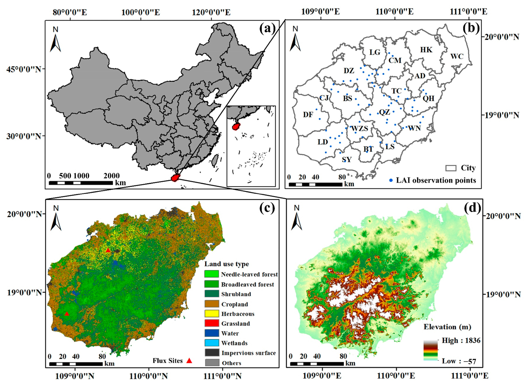
2.1. Study Area

Hainan Island (18°10′–20°10′N and 108°37′–120°05′E, Figure 1), the second largest island in China with a land area of 33,920 km2, is characterized by a tropical monsoon climate [31]. The region experiences uneven precipitation distribution, with distinct wet (May–October) and dry (November–April) seasons [34]. Due to the effect of the ocean, the annual temperature variation on the island is small, with a stable mean annual temperature of 22.5–25.6 °C. Its complex topography and superior hydrothermal resources contribute to its rich diversity of vegetation. Natural forests are mainly distributed in the middle and lower hills of the central and southern regions, while planted forests are located in the coastal and mountainous plains [34].

2.2. Data and Data Pre-Processing

2.2.1. Land Use and Land Cover

Five years of fine land cover products published by the Chinese Academy of Sciences, namely, GLC_FCS30 (2000, 2005, 2010, 2015, and 2020), were used as the land cover map [35]. Combining the study requirements with the characteristics of the study area, 29 land cover types were reclassified into cropland, herbaceous, broadleaved forest (BLF), needle-leaved forest (NLF), shrubland, grassland, wetlands, water, impervious surface and others (Figure 1c).

2.2.2. Land Surface Water Index (LSWI) and Leaf Area Index (LAI)

To improve computational efficiency and reduce inversion uncertainty [19], multi-source RS images covering HN from 2000 to 2020 were selected and preprocessed on the Google Earth Engine (GEE) platform (Table 1). Atmospherically corrected Landsat surface reflectance data for within six (123/046, 123/047, 124/046, 124/047, 125/046 and 125/047) WRS-2 paths/rows were selected, including 918 Landsat-5 images, 1273 Landsat-7 images, and 830 Landsat-8 images. Clouds and shadows were removed using pixel quality attributes generated by the FMASK algorithm (i.e., the “pixel_qa” band). In addition, 3038 Sentinel-2 Level-2A surface reflectance images were selected, and a bit-masked band with cloud mask information, namely the QA60 band, was used to mask cloud pixels.
This study used Ordinary Least Squares (OLS) regression to correct reflectance differences between satellite sensors and to eliminate spurious temporal trends. A total of 600 pixels, comprising 100 randomly and uniformly selected pixels from each of six reclassified land use types (excluding wetlands, water, impervious surfaces, and others), were used as sample points. Multiple image pairs with the closest dates and of good quality from different sensors were selected for different years. LSWI (calculated using Equation (1)), which describes the leaf water content [36], was extracted based on the sample points from the selected image pairs; this in turn calculated the best-fit coefficient for pixels belonging to the same land use type in the case of minimal residuals. The average fitting coefficients served as the stretch factor for image fusion in the current year, as well as two years before and after. Finally, LSWI with null and missing daily values was filled using temporal linear interpolation.
L S W I = ρ N I R ρ S W I R ρ N I R + ρ S W I R
where ρ N I R and ρ S W I R are the surface reflectance values of the near-infrared and short-wave infrared spectral bands of the Landsat Thematic Mapper/Enhanced Thematic Mapper Plus/Operational Land Imager (TM/ETM +/OLI) and Sentinel-2A MultiSpectral Instrument (MSI) imagery, respectively (Table 1).
In this study, the Sentinel-2 Level 2 Prototype Processor (SL2P) [37] was used to invert LAI using Landsat series (including Landsat-5 TM, Landsat-7 ETM+ and Landsat-8 OLI) and Sentinel satellite data with de-clouding and atmospheric correction. A Whittaker smoother [38] was then used to construct a continuous daily LAI to drive the RS physiological process model. SL2P is a collection of artificial neural networks (ANNs) trained using radiative transfer model (i.e., PROSAIL model) simulations based on the joint distribution of leaf, canopy, soil, and collected geometric parameters [39]. The ANNs trained by different sensors have the same neural network, including an input layer with normalized data, a hidden layer comprising 5 neurons and a tangent sigmoid transfer function, and an output layer with 1 neuron and a linear transfer function [39,40]. The input layer consists of different spectral bands (Table 1) and 3 geometrical configurations: sun zenith angle, view zenith angle, and relative azimuth angle. Numerous studies have shown that reliable high-resolution daily-scale LAI estimation can be achieved based on the SL2P algorithm that effectively addresses the limitations of sensor revisit frequency or image cost [40,41,42]. In addition, LAI biophysical parameters retrieved from the decimal spatial resolution sensor are more applicable to regional- and local-scale ecosystems [39].

2.2.3. Other Input Data of Model

  • Meteorological data
Mean daily temperature (Ta), precipitation, and wind speed at 16 weather stations in HN were sourced from the China Meteorological Administration (CMA; http://data.cma.cn/ (accessed on 6 August 2021)). Site-scale climate variables were interpolated to a 30 m spatial resolution using spline interpolation considering the elevation effects. Daily surface solar radiation, surface net solar radiation, and dew point temperature (DP) were calculated from ERA5-Land hourly data (https://www.ecmwf.int/ (accessed on 10 March 2023)) for the period 2000–2020, which shows superior performance in various land surface applications [4]. These daily reanalysis data were averaged using two 12-hour datasets in a day and resampled to 30 m using bilinear interpolation. Furthermore, daily vapor pressure deficit (VPD) was calculated using processed Ta and DP [43].
2.
Nitrogen data
Gridded datasets of dry and wet atmospheric inorganic nitrogen deposition [44,45] were acquired from the National Ecosystem Science Data Center (http://www.nesdc.org.cn/ (accessed on 10 March 2023)). NOx (including NO2, NO3 and HNO3) during the periods 2006–2010 and 2011–2015 were applied to 2000–2010 and 2011–2020, respectively. The cumulative value of these three nitrogen indicators was used as the nitrogen limitation factor being input into the model.
3.
Elevation Data
The Advanced Spaceborne Thermal Emission and Reflection Radiometer Global Digital Elevation Model (ASTER GDEM) with a spatial resolution of 30 m was acquired from the Geospatial Data Cloud (https://www.gscloud.cn/ (accessed on 10 March 2023)). ASTER GDEM was used to characterize the landscape and its impact on NPP.

2.2.4. Evaluation Data

  • NPP benchmark maps
The global daily NPP dataset (BEPS_NPP_8km) generated from the boreal ecosystem productivity simulator (BEPS) model (https://www.nesdc.org.cn (accessed on 10 March 2023)) for 2000–2019 with a spatial resolution of 0.072727° (about 8 km) [22], the yearly MOD17A3HGF data product (MODIS_NPP) (https://lpdaac.usgs.gov (accessed on 10 March 2023)) for 2001–2020 with a spatial resolution of 500, m and yearly NPP_MODIS_500m_V60 (GLASS_NPP) for 2000–2020 with a 500 m spatial resolution from the National Earth System Science Data Center, National Science & Technology Infrastructure of China (http://www.geodata.cn (accessed on 8 April 2023)) were used as the validation data. The study used ENVI 5.3 to read BEPS_NPP_8km, add the header file, and then calculate and mask the monthly and yearly BEPS_NPP_8km in HN based on Python. MODIS Projection Tools were used for mosaic completion, reprojection, and format conversion of MODIS_NPP.
2.
NEE evaluation map and measured NEE from flux stations
A data-driven upscale NEE production (CGER_NEE) at 10-day and 0.1° resolution during the period 2000–2019 was produced using the random forest approach based on FLUXNET 2015 datasets, which performed well in different plant functional types (https://db.cger.nies.go.jp/ged/en/ (accessed on 3 November 2023)) [46]. From published research, the measured NEE from flux stations covering HN were obtained, including NEE for natural tropical forests at the Jianfengling flux station during the period 2006–2009 and for planted forests at the Danzhou flux station the period during 2010–2018 [47,48]. The opposites of annual CGER_NEE (CGER_NEP) and measured NEE were used to evaluate simulated NEPs [49].
3.
LAI benchmark map and measured LAI
The global 8-day LAI products at a 250 m spatial resolution using the bidirectional long short-term memory deep learning model for 2000–2020 [50] were combined into annual LAI (GLASS_LAI) for validating simulated LAI based on SL2P in this study. Meanwhile, measured LAIs for rubber plantations in HN in 2017 were acquired for station validation [51], with the station’s location marked in Figure 1b.

2.3. Methods

2.3.1. Vegetation Productivity Simulation

  • NPP simulation
This study integrated the optimized water stress factor (WSF) and carbon modules from BEPS [21,52,53] to simulate different vegetation NPP in HN. The absence and time lags of complex soil parameters significantly reduce the feasibility of WSF simulations [13]. Meanwhile, the input of empirical parameters and calibration factors limits the regional applicability of WSF simulations [54]. Therefore, this study innovatively incorporated WSF based on daily LSWI calculations to estimate the maximum carboxylation rate (Vm). Furthermore, BEPS, driven by meteorological data and high-precision daily LAI to couple photosynthesis, respiration, and radiative transfer, has demonstrated accuracy and reliability at several stations as well as regional and global scales [55,56,57]. Details of the simulated NPP are described below.
As the basic module for BEPS photosynthesis process, the Farquhar model successfully simulated the instantaneous photosynthetic rate (A) at the leaf scale [58] as follows:
A = min A c , A j R d
A c = V m C i τ C i + K
A j = J C i τ 4.5 C i + 10.5 τ
R d = 0.015 V m
V m = V m 25 · 2.4 T 25 / 10 · f 1 N · f 2 T · f 3 W S F
f 2 T 1 = 1 + exp 220 , 000 + 710 T + 273 / R g a s T + 273
f 3 W S F = 1 1 + L S W I 1 + L S W I m a x
where A c and A j are the Rubisco-limited and light-limited photosynthesis rates; R d is the daytime leaf dark respiration; C i is the intercellular CO2 concentration; τ is the CO2 compensation point without dark respiration; K is the constant of enzymatic reflection rate; J is the electron transfer rate [59]; V m 25 is the maximum carboxylation rate at 25 °C [59,60]; f 1 N , f 2 T [21], and f 3 W S F [61] are the restrictive functions of nitrogen (N), temperature, and WSF for V m , which range from 0 to 1; R g a s is the molar gas constant; and L S W I m a x is the maximum value of LSWI during the growth period in single pixel.
According to fluid physics, A can also be described as follows:
A = g C a C i
g f 3 W S F 10 6 g s m a x · f 1 P P F D · f 2 T · f 3 W S F · f 4 V P D R g a s T + 273
where C a is the atmospheric CO2 concentration; g is the conductance of CO2 from the plant cells to the atmosphere [21]; g s m a x is the maximum stomatal conductance; and f 1 P P F D and f 4 V P D are the constraint factors for photosynthetic photon flux density (PPFD) and VPD. f 1 P P F D was calculated according to Equations (A1)–(A9).
Combining Equations (2) and (9) and integrating the instantaneous CO2 assimilation rate according to the cosine curve variation of daily g [21], we obtain the following equation:
A = 1.27 2 g n a 1 2 2 g n 2 + c 1 2 g n d 2 a g n + b 4 a + b c 1 2 4 a + b 2 4 a c 8 a 3 2 l n 2 a g n + b + 2 a 1 2 d b + 2 a 1 2 c 1 2
where A is the minimum of A c and A j (coefficients a–d in Equations (A10)–(A12)), and g n is the midday stomatal conductance.
For spatial scale conversion from leaf to canopy, the “two-big-leaf” model was applied as follows:
A c a n o p y = L A I s u n · A s u n + L A I s h a d e · A s h a d e
L A I s u n = 2 cos θ 1 e x p Ω L A I / 2 cos θ
L A I s h a d e = L A I L A I s u n
where A c a n o p y is the canopy assimilation rate, which can be calculated by multiplying LAI with the leaf photosynthesis rate. Sunlit and shaded leaf photosynthesis rates ( A s u n and A s h a d e , respectively) can be calculated using Equation (11). θ is the solar zenith angle and Ω is the parameter describing clumping effect.
Daily gross primary productivity ( G P P d ) and monthly NPP ( N P P m o n t h ) were calculated using Equations (15) and (16) as follows:
G P P d = A c a n o p y · t · F G P P
N P P m o n t h = d = 1 d = n G P P d R a , d
where t is the day length; F G P P is the unit conversion factor; subscript d indicates the number of days; R a is the autotrophic respiration; and n is the total number of days in each month.
2.
NEP simulation
In this study, the difference between NPP and soil microbial respiration ( R h , g C/m2) was calculated to measure net ecosystem carbon storage or uptake. Annual net ecosystem productivity ( N E P y e a r ) was calculated as follows:
N E P y e a r = 1 12 N P P m o n t h R h
N E P y e a r > 0 indicates that the vegetation carbon cycle is the carbon sink; otherwise, it is the carbon source. R h can be calculated based on annual precipitation ( P y ) and temperature ( T y ) [62], which was validated in various areas for different vegetation types [3,29,63,64] as follows:
R h = 0.22 × e x p 0.0912 · T y + l n 0.3145 · P y + 1 × 30 × 0.465

2.3.2. Evaluation of Model Performance

To validate the accuracy of the model-simulated high-resolution NPP and NEP, the correlation coefficient (R), root mean square error (RMSE), and normalized root mean square error (NRMSE) were computed using Equations (19)–(21). The uncertainties in the NPP(NEP) estimates at pixel scale ( U n c e r t a i n t i e s p i x e l in Equation (22)) were defined as the RMSE of simulated multi-year annual average of NPP(NEP) relative to the annual average NPP(NEP) benchmark maps ( C F v a l i d a t e d ).
R = i = 1 n x i x ¯ y i y ¯ i = 1 n x i x ¯ 2 i = 1 n y i y ¯ 2
R M S E = 1 n i = 1 n y i x i 2
N R M S E = R M S E x m a x x m i n
U n c e r t a i n t i e s p i x e l = R M S E C F v a l i d a t e d × 100 %
where x i is the validation NPP (BEPS_NPP_8km, MODIS_NPP or GLASS_NPP) or CGER_NEP or opposites of NEE from flux stations; y i is the simulation NPP or NEP; x ¯ and y ¯ are mean values; x m a x and x m i n are maximum and minimum values; and n is the number of samples.

2.3.3. Trend Analysis

Linear regression based on pixels was used to analyze the direction and rate of NPP spatial variation [57]. The regression coefficient (Slope) is defined as the annual rate of NPP variation:
S l o p e = i = 1 n N P P i y i n N P P ¯ y ¯ i = 1 n N P P i 2 n N P P ¯ 2
where i is the number of years, y is the year, and n is the time span (n = 21); N P P ¯ and y ¯ are mean values. Slope > 0 indicates an upward trend in NPP; otherwise, the trend is opposite, with values closer to 0 indicating a more stable trend. If the significance test (F–test, p < 0.05) is passed, NPP shows a significant upward or downward trend.

2.3.4. Variation Stability Analysis

In this study, the degree of NPP fluctuation in HN during the period 2000–2020 was quantitatively assessed by calculating the coefficient of variation (CV) as follows:
C V = σ N P P / μ N P P
where σ N P P and μ N P P are the standard deviation and mean of annual NPP, respectively. A higher CV indicates a more unstable NPP variation.

2.3.5. Limitations of NPP by Natural Factors

This study investigated the limiting effects of three natural factors (temperature, precipitation, and elevation) on NPP using quantile regression (Equation (25)). Compared to OLS, quantile regression independent of outliers can characterize the global features of NPP and provide more robust parameter estimates and richer information [65].
Q y σ | X i = α σ X i
where Q y σ | X i is the σ th quantile of NPP on conditional X i ; σ is the quantile index, σ 0 , 1 ; X i represents the variables of precipitation (Xp), temperature (Xt), and elevation (Xe); and α σ denotes the regression coefficient at the σ th quantile.

2.3.6. Impact of Anthropogenic Activities on NPP

LUCC reflects anthropogenic impacts on the natural environment, thereby influencing NPP variations by regulating ecosystem structure and function. To analyze the spatial distribution of NPP gaps among cities and to identify opportunities for enhancing vegetation carbon sinks within limited land resources, the NPP at pixels were aggregated into three groups based on the mean NPP of each city and HN during the period 2000–2020. Additionally, a land use transfer matrix was constructed to quantify the changes in area and mean NPP resulting from conversions between different land use types (Equations (26) and (27)). Finally, the net change in NPP, representing the product of NPP and area, resulting from the overall transfer of single land use types, was calculated using NPP from 2020.
A i j = A 11 A 1 n A n 1 A n n
Δ N P P i j = N P P ¯ i j , a f t e r N P P ¯ i , b e f o r e
where A i j and Δ N P P i j indicate the area and NPP change from land use type i to type j; n is the number of land use types; N P P ¯ i j ,   a f t e r and N P P ¯ i , b e f o r e indicate the mean NPP before and after transfer of land use types.

3. Results

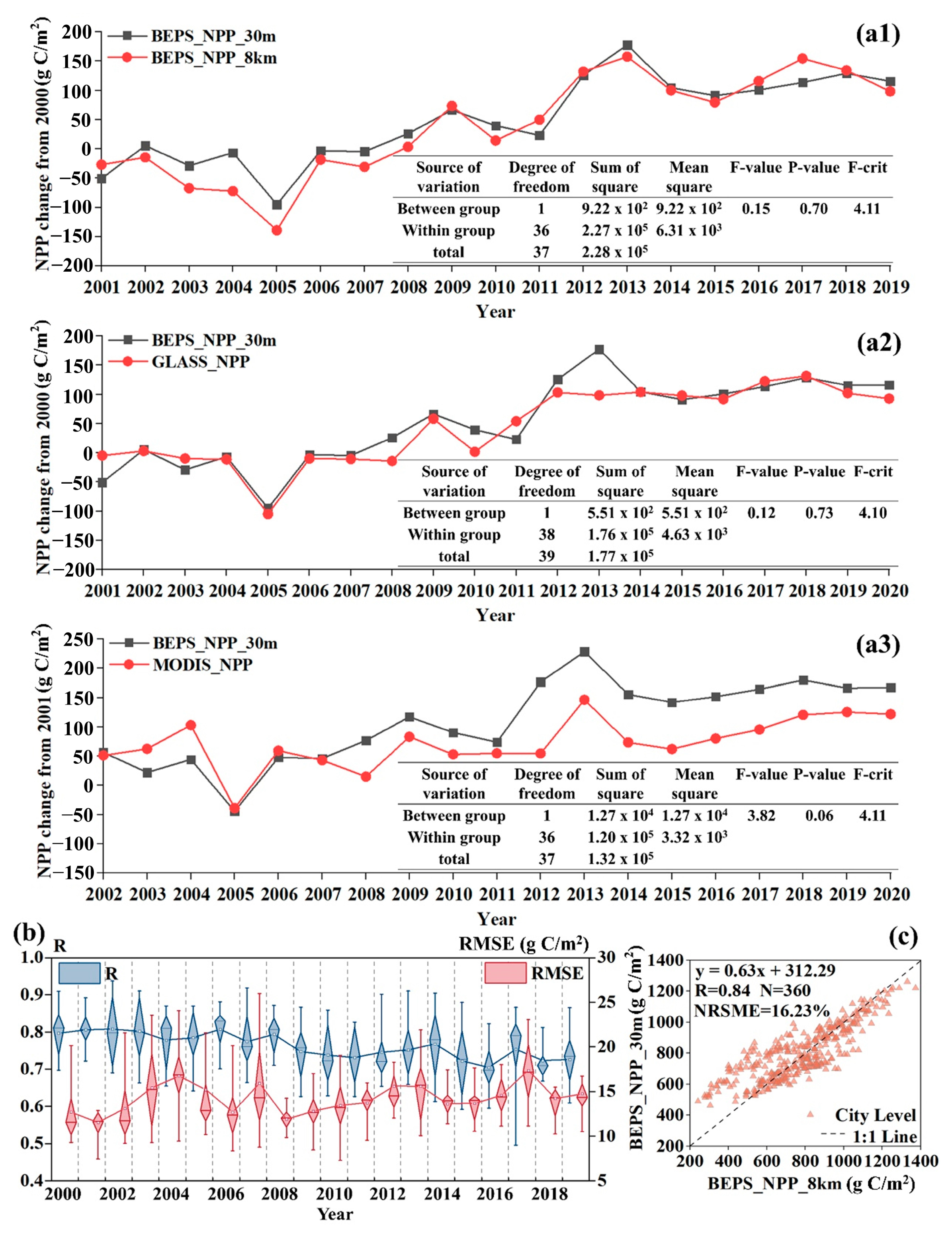
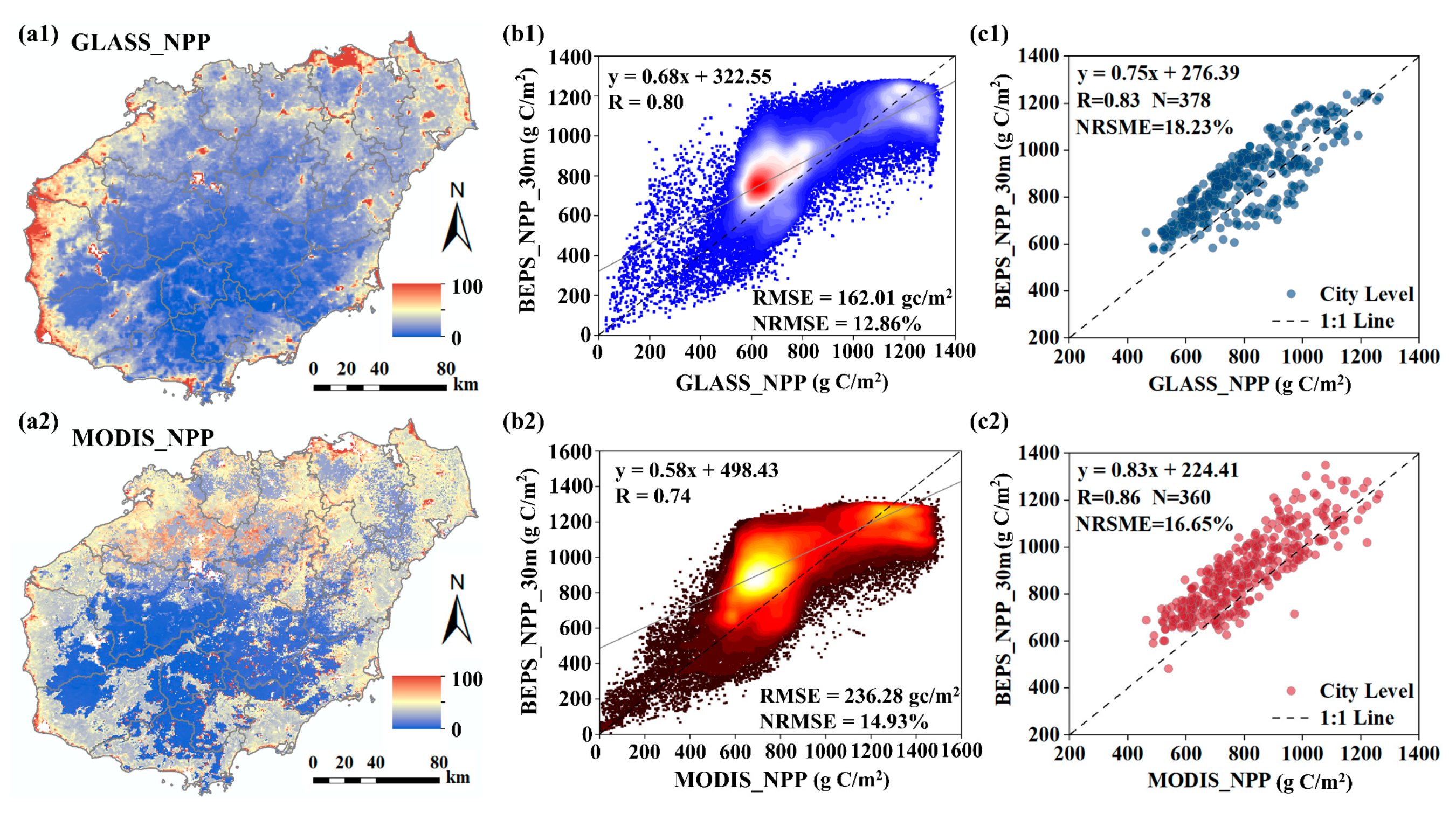
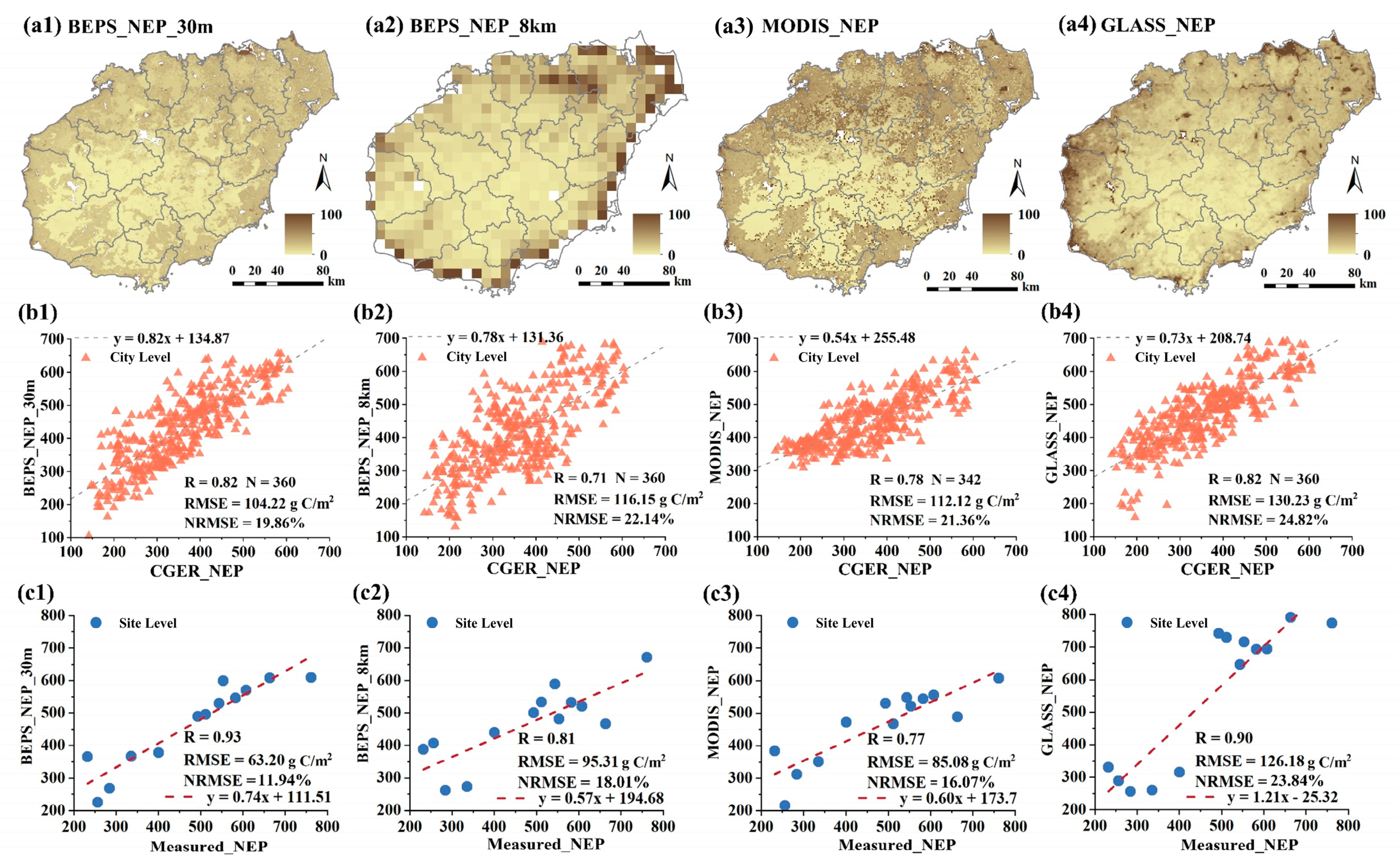
3.1. Accuracy of Carbon Dioxide Flux Simulation

The simulated NPP (BEPS_NPP_30m) and NPP benchmark maps all showed similar temporal trends, and no significant differences were found by the analysis of variance (ANOVA) (Figure 2(a1–a3)). Across the city, statistically significant correlations were observed between BEPS_NPP_30m and BEPS_NPP_8km at both yearly and monthly scales (Figure 2b,c). The R between the simulated and validated values fluctuated around 0.76, and the mean RSME ranged from 11.54 to 17.38 g C/m2. The spatial distribution of simulated NPP uncertainties showed that the percentage of larger uncertainties for BEPS_NPP_30m and MODIS_NPP was higher compared to GLASS_NPP, and the uncertainties showed a spatial pattern of being low in inland areas and high along the coast (Figure 3(a1,a2)). BEPS_NPP_30m had a high correlation with both GLASS_NPP and MODIS_NPP (R > 0.73, p < 0.001 and NRMSE < 19%), both at pixel scales and citywide (Figure 3(b1–c2)). The pixel-scale accuracy validation results for each year (R ≥ 0.69 and NRMSE < 20%) also confirmed the reliability of BEPS_NPP_30m (Table A1). To further evaluate the performance of BEPS at a 30 m resolution (BEPS_30m), this study compared the NEPs (BEPS_NEP_8km, MODIS_NEP, and GLASS_NEP) computed using NPP benchmark maps combined with Equation (17) with CGER_NEP and in situ flux measurements (as mentioned in Section 2.2.4.), respectively. Both city-scale and site-scale evaluations have shown the accuracy of all NEP estimates (R ≥ 0.70 and NRMSE < 25%, Figure 4(b1–c4)), with BEPS_NEP_30m having the highest R and lowest RMSE (Figure 4(b1,c1)). BEPS_30m effectively reduced the uncertainties of NEP simulations in coastal areas, which have relatively more mixed pixels (Figure 4(a1)). Therefore, BEPS_30m has no significant systematic error and is capable of inverting high-resolution NPP and NEP in small regions.

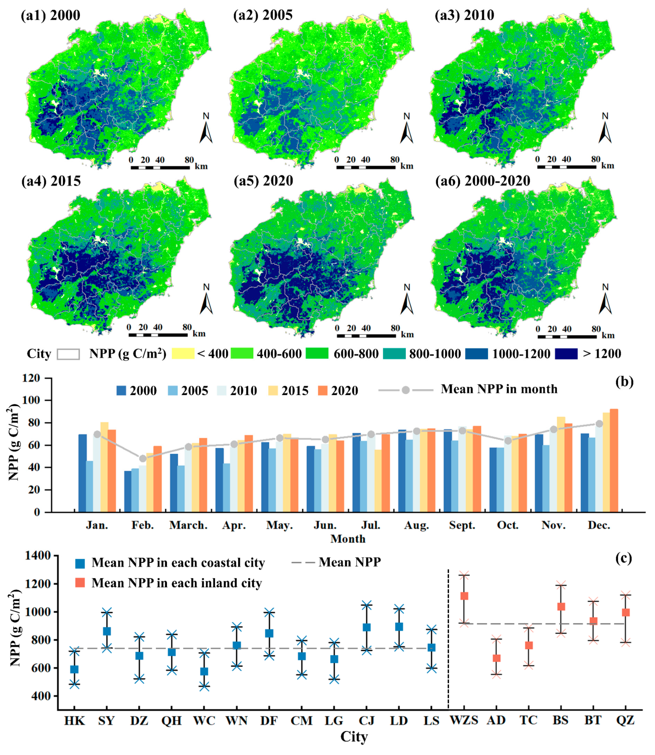
3.2. Spatiotemporal Variations in NPP

The multi-year NPP in HN showed a fluctuating yet upward trend, increasing from 751.19 g C/m2 in 2000 to 867.44 g C/m2 in 2020 (Figure 2a). The NPP in HN exhibited significant spatial heterogeneity, with high values concentrated in inland cities and low values in coastal cities (Figure 5(a1–a6,c)). The reduction in high-NPP (>1000 g C/m2) areas contributed to the overall decrease in NPP in 2005 compared to 2000 (Figure 5(a2)), while the central regions of the island with NPP above 1200 g C/m2 expanded southward, increasing in area by 8.4% and 3.5%, respectively (Figure 5(a3–a5)). Monthly variations in NPP analysis revealed troughs in February and October, with peaks in November and December (Figure 5b).
Over the preceding two decades, NPP variations in coastal areas were unstable, with CV mostly above 0.2, while variations in high NPP were rather stable, with CV mostly within 0.1. (Figure 6a). NPP increased more in the western part of HN than in the eastern part and decreased significantly in northern HK and southern SY, which are close to the sea (Figure 6b). Overall, the conversion of forests to impervious surface due to urbanization negatively impacted the carbon sink capacity of HN, as evidenced by higher CV and significant downward trends in NPP.

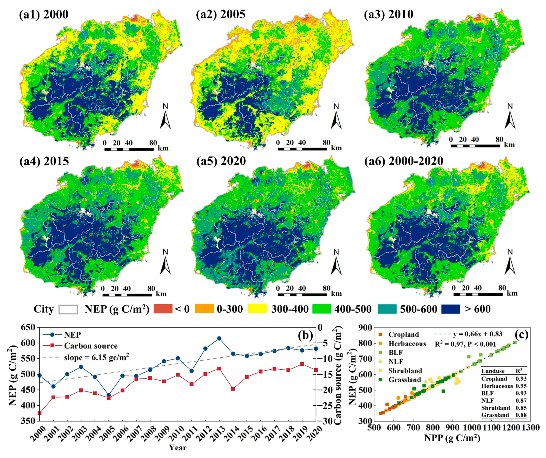
3.3. Evaluation of Carbon Sink Based on NEP

The vegetation carbon sink capacity was assessed by BEPS_NEP_30m based on the relationship model with BEPS_NPP_30m. The results showed that NEP exhibited a spatial decreasing trend from the inland regions to the coastal areas of HN (Figure 7(a1–a6)). The increase in areas with NEP > 400 g C/m2 since 2010 (Figure 7(a3)) and the near-zero carbon sources year-by-year (Figure 7b) have effectively improved the carbon sink capacity of this tropical island. Moreover, NEP and NPP with consistent spatiotemporal patterns were significantly correlated across different vegetation types (Figure 7c).

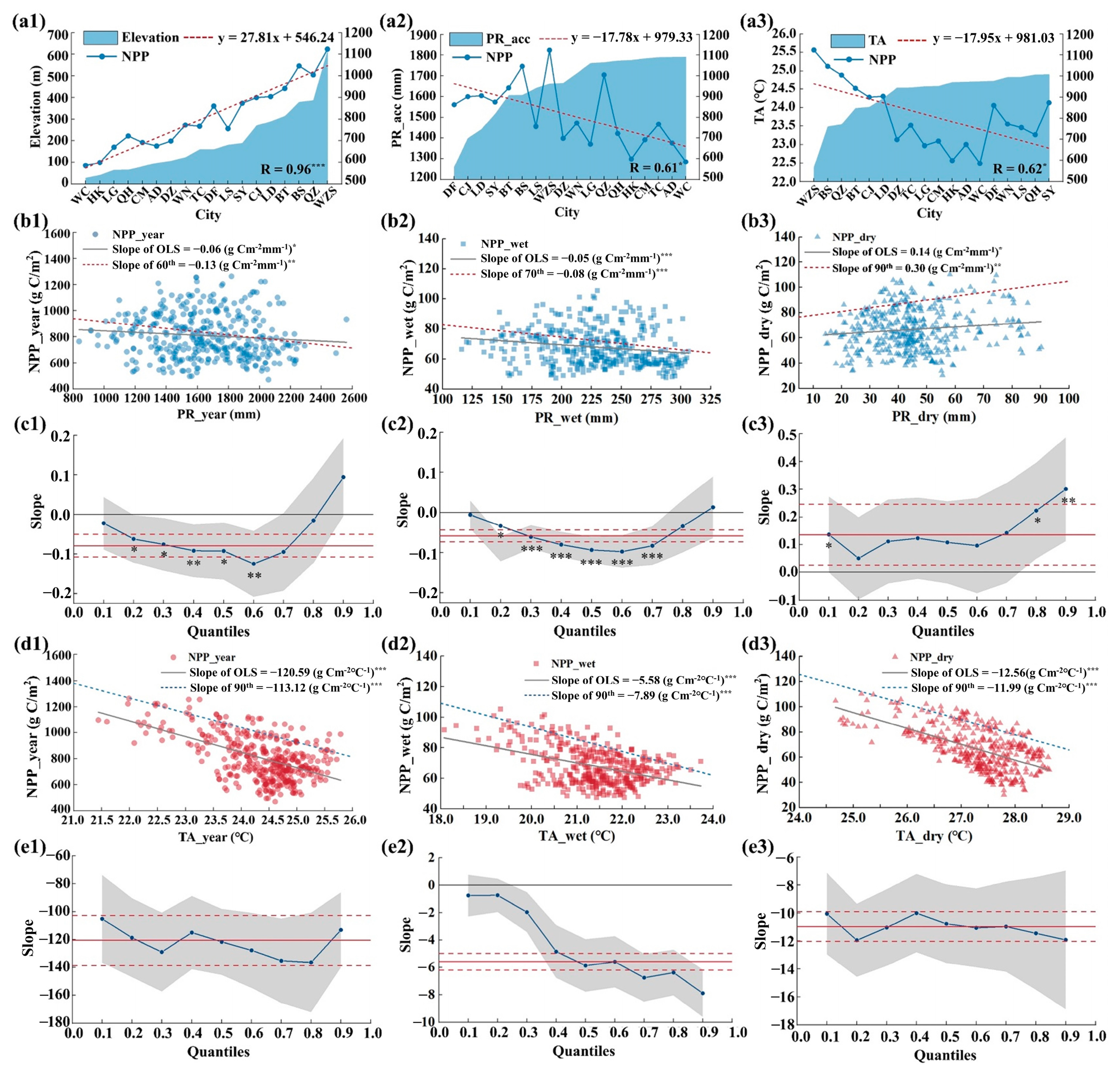
3.4. Effects of Natural Factors on NPP

NPP increased with elevation and decreased with annual precipitation and mean annual temperature (Figure 8(a1–a3)). Considering the distinct wet and dry seasons in HN, the citywide regression estimates further revealed significant linear relationships of annual NPP, wet-season mean NPP, and dry-season mean NPP with precipitation and temperature (Figure 8(b1–b3,d1–d3)). The slopes at the 60th and 70th quartiles described the slight negative limiting effect of annual and wet-season mean precipitation on NPP, with slopes of −0.13 and −0.08 g C/m2 mm, respectively (Figure 8(c1,c2)). The slope at the 90th quantile revealed a significant positive correlation between precipitation and dry-season mean NPP, with an estimated rate of change in vegetation NPP of 0.30 g C/m2 with a 1 mm increase in precipitation and a 95% confidence interval (CI) of 0.11–0.49 g C/m2 (Figure 8(c3)). The limiting effect of temperature was negative under all three conditions, and annual NPP increased by 113.12 g C/m2 with a 1 °C reduction in temperature. Compared to the negative limiting effect of wet-season temperature (slope = −7.89 g C/m2 °C, 95% CI: −9.60 to −6.18 g C/m2 °C), the negative limiting effect of dry-season temperature was stronger (slope = −11.99 g C/m2 °C (95% CI: −14.59 to −9.39 g C/m2 °C), with a reduction of 4.1 g C/m2 (Figure 8(e1–e3)).

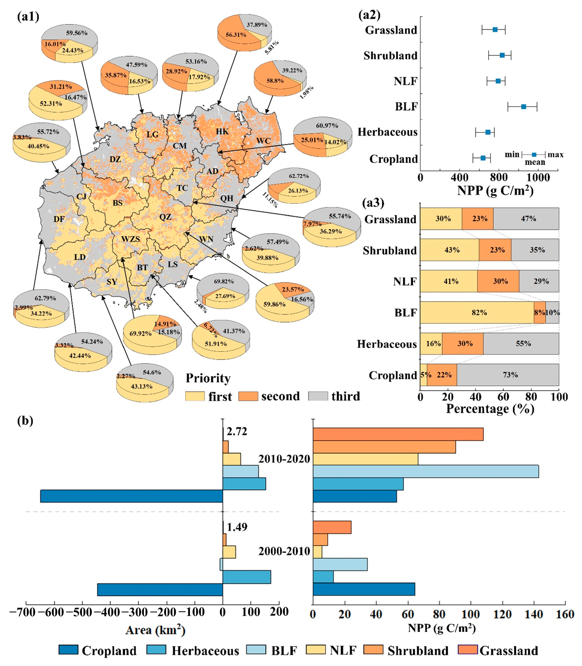
3.5. Response of NPP to Land Use Change

The spatial distribution of NPP priorities showed that the high-altitude inland areas had a natural advantage in vegetation carbon sequestration, and the narrowing of NPP gaps in the northeastern part of the island and coastal areas was critical for enhancing carbon sinks (Figure 9(a1)). The order of NPP of different land use types is as follows: BLF > shrubland > NLF > grassland > herbaceous > cropland (Figure 9(a2,a3)). During the period 2010–2020, fewer cropland areas yielded higher NPP, suggesting an improvement in cropland quality (Figure 9b). Compared to 2000–2010, a 17.92 km2 reduction in herbaceous areas increased NPP by 44.3 g C/m2, and an additional 1.23 km2 of grassland areas added 44.3 g C/m2 of grassland NPP (Figure 9b).
To further explore the impact of LUCC on NPP, this study calculated the changes in NPP due to land use type transfer during the period 2000–2020 (Table 2) and analyzed the net change in NPP for each land use type transfer in and out (Table 3). The results indicated that transfers between different vegetation types positively affected NPP enhancement, variously mitigating the decline in NPP due to the increase in impervious surface areas (Table 2). The net change in NPP for all land use types combined increased by 0.301 Tg C (Table 3), and the net increases in NPP transferred from BLF and herbaceous greatly compensated for the net decreases in NPP from cropland. Overall, although the expansion of built-up areas had a negative impact on NPP, this was partly compensated for by the increase in vegetation carbon dioxide fluxes per unit area and the dynamics among different vegetation types.

4. Discussion

4.1. Improvements of the Remote Sensing Methods to Estimate Carbon Dioxide Flux

Currently, carbon dioxide flux estimation predominantly occurs in large-scale regions, using low- and medium-resolution datasets such as MODIS vegetation index products. This approach, however, fails to provide refined NPP and NEP estimations within spatially heterogeneous urban areas. Addressing this gap, this study developed a 30 m resolution BEPS model by incorporating daily-scale LAI and LSWI retrieved from multi-source RS data and yielded vegetation carbon dioxide fluxes characterized by high spatiotemporal resolution and accuracy. The daily LWSIs, which indirectly represents the combined effects of soil factors on vegetation growth, were used to calculate WSF, maintaining consistency in temporal dynamics and spatial resolution with LAI. As an important factor influencing the stomatal conductance and photosynthesis of vegetation, LSWI-based WSF had been introduced in most ecosystem models for vegetation productivity modelling at regional or global scales [66,67,68]. Meanwhile, the input of high-resolution LAI with accurate simulation (Figure A1 and Figure A2) visually expressed the dynamic effects of climatic conditions on vegetation growth, reducing the model’s reliance on climatic data [69,70]. Notably, the results showed that BEPS_30m achieves heightened estimation accuracy for vegetation carbon dioxide fluxes compared to measurements from flux stations. An assessment of the applicability of BEPS_30m in this study area revealed close temporal trends with NPP benchmark maps (Figure 2(a1–a3)), despite some variances across vegetation types, which helped to accurately capture the monthly period of NPP (Figure 2b). Meanwhile, the spatial uncertainties of BEPS_NPP_30m were low, particularly in regions with higher vegetation cover, while the areas with uncertainties larger than 100% only accounted for 2.8% and 3.6% of HN (Figure 3(a1,a2)). Moreover, it has been proven that the spatial distribution of NEP in tropical vegetation depends on mean annual temperature and precipitation [71,72], thus demonstrating the feasibility of integrating carbon emission–temperature and precipitation relationships into NEP simulation [29,63,64,73]. Notably, the simulated NEPs exhibited strong correlation with CGER_NEP and in-suit flux measurements (Figure 4(b1–c4), with BEPS_NEP_30m having the highest R and lowest RMSE (Figure 4(b1,c1)). Meanwhile, the input of remote sensing indices reduced simulation uncertainties of BEPS_NEP_30m in coastal areas with more mixed pixels (Figure 4a), effectively combating the issue of large spatial mismatch between existing carbon dioxide flux simulations and flux station-derived measurements. In summary, the comprehensive use of high-resolution RS data and optimized inversion algorithms for vegetation physiological variables can help realize “top-down” (i.e., region-to-site) multi-scale vegetation productivity simulation. Despite unavoidable errors, the simulated NPP and NEP were within acceptable and reasonable variability (NRMSE < 25%, Figure 2c, Figure 3(b1–c2) and Figure 4(b1–c4), suggesting that BEPS_30m with favorable stability and robustness can be generalized to similar climate zones and ecosystems. These detailed and reliable city-scale vegetation carbon dioxide flux simulations not only fill the existing data gaps, but can also be better used to quantify the impacts of natural factors and human activities on the carbon balance of tropical vegetation.

4.2. Influencing Factors of Vegetation NPP

Quantitative assessment of the response of tropical vegetation carbon cycle to natural factors and anthropogenic activities can help clarify the contribution of tropical regions to global carbon sequestration [74]. This study assessed the contributions of elevation, climate factors, and land cover change to NPP of HN over the past 21 years, aiming to provide a new reference for the realization of China’s carbon neutrality and to provide scientific evidence for the debate on whether the tropics act as a carbon source or sink. Our findings indicated that, unlike that in some tropical areas, vegetation productivity in HN fluctuated seasonally, but many years assumed a stable carbon sink status (Figure 7b). Possible reasons for this phenomenon include differences in climate type and forest integrity, owing to different geographical locations and ecological management practices [75]. Taking the Amazon rainforest as an example, extreme climatic events (e.g., droughts) and forest degradation disrupt the balance of local carbon-containing gases, which in turn leads to a shift in carbon dynamics [76]. However, the increase in dry-season precipitation in HN from 2000 to 2020 provides more suitable natural conditions for vegetation growth. At the same time, the transformation from young to mature forests, resulting from years of large-scale afforestation activities and efforts in HN, further contributed to the improvement in NPP. Differences in vegetation growth and distribution due to altitudinal differentiation characteristics had a significant impact on the spatial distribution of NPP, with BLF and NLF distributed in the central high-elevation region producing higher NPP. Furthermore, in the quantile regression models, unequal slopes implied the presence of other constraints not considered [54]. To minimize confounding effects, this study used the upper bound of the response variable distribution to estimate the restricted effects of the explanatory variables, provided that the significance conditions were satisfied [77]. Our conclusion that the limiting effect of temperature on NPP was significantly greater than that of precipitation is consistent with the findings of Guo et al. [24]. The quantile regression model indicated that increased dry-season precipitation contributed to an increase in NPP, and the opposite occurred during the wet season. This finding also corroborates the view of Schuur [78] that high rainfall in the tropics negatively affects the productivity of humid vegetation. Although precipitation can mitigate the negative effects of drought to some extent, excessive precipitation in wet ecosystems may inhibit NPP increase by reducing solar radiation or soil oxygen.
Furthermore, anthropogenic LUCC shows a significant impact on global vegetation carbon dioxide fluxes, particularly in tropical forests. For instance, deforestation triggered by agricultural and pastoral expansion is a major cause of carbon loss and emissions from forests in South America and Southeast Asian tropics [79]. Conversely, the continued increase in greenness in HN has effectively compensated for the negative impact of rapid urban expansion on ecological interventions and helped consolidate and enhance the ecosystem carbon sink capacity. The development of tourism in SY and HK coastal areas and LUCC caused by eastern coastal agriculture and fishery production have led to a decline in NPP. However, this negative effect has been offset by an increase in NPP due to high forest cover (increase in forest, grassland, and shrubland) in the central high-elevation region. These findings are consistent with the reports of Zhou et al. [80] that the higher carbon sinks in inland areas than in coastal areas are caused by the difference in service values between different cities in HN. Meanwhile, for the third-priority cities located in the coastal areas (Figure 9(a1)), upgrading the existing land quality and optimizing the urban functional pattern are the key strategies to increase NPP [80]. However, according to the Intergovernmental Panel on Climate Change (IPCC), sea-level rise due to global warming is irreversible. Thus, coastal erosion due to frequent flooding may exacerbate the reduction in the carbon sink capacity of coastal areas. Exploiting the full potential of blue carbon in coastal zones and improving the quality of cropland in the future are effective strategies to accelerate the carbon neutrality of HN.

4.3. Uncertainties and Limitations

There remained some uncertainties in input data and model parameterization for this study. The limitations in accurately retrieving high-resolution leaf area index (LAI) products in dense forest canopy could be an important uncertainty source of ecological modelling. To this end, additional efforts have been made in this study to minimize uncertainties in LAI simulations by (1) adopting the most widely acknowledged standard algorithm (SL2P) to retrieve the decametric LAI from the Sentinel-2 and Landsat and (2) correcting the retrieved effective LAI into true LAI by dividing the assumed clumping index. SL2P-based LAI had high correlation with both GLASS_LAI and measured LAI, i.e., R is 0.73 and 0.86, and NRMSE is 17.23% and 11.61%, respectively (Figure A1b,c). Meanwhile, the high consistency of the spatial distribution (Figure A1(a1,a2)) and fewer overestimated/underestimated pixels (Figure A2) proved the accuracy of simulated LAI. Meanwhile, considering the inversion uncertainties caused by cloud contamination and missing data, OLS was applied to eliminate the reflectivity differences among various sensors, coupled with interpolation to minimize LSWI computational uncertainty [19]. Furthermore, with only temperature and precipitation data considered, the error in R h calculated using a globally generalized method was 2–4% [81,82], thus influencing the NEP estimation accuracy to some extent. Despite the inherent uncertainties in the semi-empirical model, simulated NEP with good accuracy can provide an overall understanding of the spatiotemporal variability of vegetation carbon sinks in HN. Therefore, future studies should focus on comparing and exploring various R h estimation methods for different vegetation types, including semi-empirical and mechanistic models, to further improve the estimation accuracy of NEP.
Additionally, some limitations are discussed below. First, compared to inland areas, there are larger spatial uncertainties in vegetation carbon dioxide flux simulations in coastal areas with more mixed pixels. Nevertheless, these regions have a relatively minor influence on the carbon dynamics within HN. Thus, their lower NPP estimation precision has limited impact [83]. Second, the validation of NEP simulations for diverse ecosystems is constrained by the scarcity of flux stations within HN. Lastly, for a more comprehensive assessment of the ecological restoration contribution to vegetation productivity, it is essential to consider the impacts of anthropogenic activities and environmental factors on different vegetation across multiple scales and types in future studies. Despite these limitations, the model improvements proposed in this study are considered reliable, and most of the presented results can be supported by previous studies, providing a strong reference for the assessment of vegetation carbon sinks in the tropics.

5. Conclusions

In this study, high-spatiotemporal-resolution tropical vegetation carbon dioxide fluxes were obtained using a multi-source RS data-driven physiological model. We aimed to quantify the contributions of climate and anthropogenic factors to NPP changes and evaluate tropical vegetation carbon sinks using NEP as an indicator. BEPS_30m accurately captures the vegetation carbon dioxide flux dynamics in HN at a fine resolution of 30 m, yielding robust estimates with NRMSE < 25% at both city and site levels. The observed increasing trend in NPP and NEP (5.81 and 4.29 g C/m2 year) suggests the stable carbon sink status of this tropical island during the period 2000–2020. Ecological construction measures promoted NPP growth in inland areas, while urbanization hindered the stability of NPP in coastal areas. Additionally, elevation, temperature, and precipitation emerged as significant limiting factors influencing NPP. Specifically, a 1 °C increase in temperature led to a respective decrease of 7.89 and 11.99 g C/m2 in NPP during the wet and dry seasons, while a 1 mm increase in dry-season precipitation increased NPP by 0.30 g C/m2. The increase in vegetation NPP per unit area and the dynamics of land use types are critical for offsetting the negative impacts of expanding impervious surface on carbon sink enhancement. The proposed carbon dioxide flux simulation and assessment framework in this study provide unique insights into enhancing the carbon sink potential of tropical vegetation, thereby supporting the achievement of carbon neutrality objectives.

Author Contributions

R.X. Conceptualization, Methodology, Software, Validation, Writing—original draft, and Writing—review and editing. J.Z. Conceptualization, Funding acquisition, Writing—review and editing, Supervision. J.W. Software, Methodology, Writing—review and editing, Validation. F.Y. Methodology, Writing—review and editing, Validation. S.Z. Methodology, Software, Writing—review and editing, Validation. All authors have read and agreed to the published version of the manuscript.

Funding

This work was jointly supported by The Finance Science and Technology Project of Hainan Province (No. ZDYF2021SHFZ063), Central Guiding Local Science and Technology Development Fund of Shandong—Yellow River Basin Collaborative Science and Technology Innovation Special Project (No. YDZX2023019), and The Natural Science Foundation of China (No. 41871253, No. 42071425).

Data Availability Statement

The data supporting this study are available from the following resources in the public domain. Land use and land cover data (GLC_FCS30) were downloaded from the Data Sharing and Service Portal of Big Earth Data Science Engineering Project (CASEarth) at https://data.casearth.cn (accessed on 10 March 2023). The Landsat images and Sentinel-2A MSI are freely available from Google Earth Engine platform at https://developers.google.com/earth-engine/datasets/ (accessed on 10 March 2023) and the DEM was obtained from the Geospatial Data Cloud at https://www.gscloud.cn/ (accessed on 10 March 2023). Meteorological data are freely available to download from the China Meteorological Administration at http://data.cma.cn/ (accessed on 6 August 2021) and European Centre for Medium-Range Weather Forecasts at https://www.ecmwf.int/ (accessed on 10 March 2023), respectively. Nitrogen data were derived from the National Ecosystem Science Data Center (NESDC) at http://www.nesdc.org.cn/ (accessed on 10 March 2023). The global daily NPP dataset, the yearly NPP_MODIS_500m_V60 dataset, and the yearly MOD17A3HGF data product are from NESDC (http://www.nesdc.org.cn/ (accessed on 10 March 2023)), National Earth System Science Data Center, National Science & Technology Infrastructure of China (http://www.geodata.cn (accessed on 8 April 2023)), and the USGS Land Processes Distributed Active Archive Center (https://lpdaac.usgs.gov (accessed on 10 March 2023)), respectively.

Acknowledgments

The authors would like to thank the editors and all anonymous reviewers for their valuable comments and useful suggestions.

Conflicts of Interest

The authors declare no conflict of interest.

Appendix A. Model Structure Supplement

This study uses a “two-big-leaf” model to simulate canopy radiation transmission. Sunlit leaves are exposed to direct radiation (Sdir), while shaded leaves are only exposed to diffuse radiation, as follows:
S d i f / S g = 0.13 , R > 0.8 0.943 + 0.734 R 0.49 R 2 + 1.796 R 3 + 2.058 R 4 , R < 0.8
S d i r = S g S d i f
S s h a d e = S d i f S d i f , u n d e r L A I + C
S s u n = S d i r · cos α cos θ + S s h a d e
S d i f , u n d e r = S d i f · e 0.5 Ω L A I cos θ ¯
cos θ ¯ = 0.025 L A I + 0.537
C = 0.07 Ω · S d i r 1.1 0.1 L A I · e x p cos θ
Ω = 0.6 ,       Needle leaved   forest 0.7 ,       Broadleave   forest 0.8 ,       shurubland 0.9 ,       herbeous ,   cropland   and   grassland
where the judgment index for quantifying sky cloud cover R = S g S 0 / cos θ ; S0 is the solar constant; Sg is the daily gross solar radiation; Sshade and Ssun are the solar radiation absorbed by shaded leaves and sunlit leaves, respectively; Sdif,under is the scattered radiation below the canopy; C represents multiple scattered radiation; α is the angle of the sunlit leaf; θ is the solar altitude angle; and Ω is the clumping index [52,59].
Then, the solar radiation intercepted and absorbed by the canopy was converted into photosynthetic photon flux density (PPFD), which directly drives vegetation photosynthesis, using Equation (A9):
P P F D s u n s h a d e = 4.45 η · π 2 · S s u n s h a d e
where η is the percentage of photosynthetically active radiation in the gross solar radiation.
The coefficients for calculating the photosynthetic rate of plant leaves are as follows:
For Ac:
a = K + C a 2 b = 2 V m 2 τ + K C a + 2 R d K + C a c = V m R d 2
For Aj:
a = 2.3 τ + C a 2 b = 0.4 J 4.3 τ C a + 2 R d 2.3 τ + C a c = 0.2 J R d 2
d = a g n 2 + b g n + c 1 2

Appendix B. Accuracy of NPP Simulations at Pixel Scales

Table A1. At pixel scales, comparison of BEPS_NPP_30m with GLASS_NPP and MODIS_NPP.
YearGLASS_NPPMODIS_NPP
RRMSE
(g C/m2)
NRMSERRMSE
(g C/m2)
NRMSE
20000.78159.5614.87%
20010.83146.5911.63%0.74256.0317.51%
20020.82155.0312.10%0.77218.4614.91%
20030.75170.8713.41%0.80184.0612.67%
20040.84160.9312.60%0.72265.0917.64%
20050.73177.9115.13%0.69274.5319.47%
20060.76171.7513.64%0.78184.0612.64%
20070.78146.5111.96%0.75182.7113.10%
20080.81169.6014.12%0.77241.3916.63%
20090.80157.8312.56%0.70278.4019.07%
20100.77179.5814.45%0.70271.2318.62%
20110.85142.2111.25%0.74200.8212.97%
20120.77218.6216.69%0.73264.2916.57%
20130.84139.2510.90%0.78192.4311.47%
20140.86144.7411.10%0.76228.5014.84%
20150.75180.5913.83%0.70279.5917.71%
20160.77168.8813.30%0.71240.7816.21%
20170.82176.5213.83%0.76247.2716.74%
20180.80166.3012.74%0.73240.1315.79%
20190.78194.5015.30%0.74252.7316.51%
20200.79200.6512.61%0.74268.7017.87%
Note: All correlation coefficients were significant at the 0.001 confidence level.

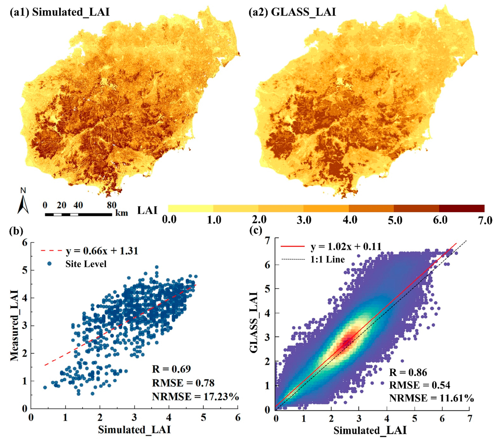
Appendix C. Accuracy of LAI Simulations

Figure A1. Spatial distribution of (a1) simulated LAI and (a2) GLASS LAI from the period 2000–2020. Comparison of simulated LAI with (b) measured LAI of rubber forest in 2017 and (c) GLASS LAI in the period 2000–2020.
Remotesensing 15 05677 g0a1
Figure A2. Gap between GLASS LAI and simulated LAI per month during the period 2000–2020.
Remotesensing 15 05677 g0a2

References

  1. Piao, S.L.; Yue, C.; Ding, J.Z.; Guo, Z.T. Perspectives on the role of terrestrial ecosystems in the ‘carbon neutrality’ strategy. Sci. China-Earth Sci. 2022, 65, 1178–1186. [Google Scholar] [CrossRef]
  2. Zhang, D.N.; Zhao, Y.H.; Wu, J.S. Assessment of carbon balance attribution and carbon storage potential in China’s terrestrial ecosystem. Resour. Conserv. Recycl. 2023, 189, 106748. [Google Scholar] [CrossRef]
  3. Cao, S.P.; Yi, H.; Zhang, L.F.; Sun, Q.; Zhang, Y.L.; Li, H.Z.; Wei, X.; Liu, Y.X. Spatiotemporal dynamics of vegetation net ecosystem productivity and its response to drought in Northwest China. GIlscience Remote Sens. 2023, 60, 2194597. [Google Scholar] [CrossRef]
  4. Wang, S.; Zhang, Y.; Ju, W.; Chen, J.M.; Ciais, P.; Cescatti, A.; Sardans, J.; Janssens, I.A.; Wu, M.; Berry, J.A.; et al. Recent global decline of CO2 fertilization effects on vegetation photosynthesis. Science 2020, 370, 1295–1300. [Google Scholar] [CrossRef]
  5. Gamage, D.; Thompson, M.; Sutherland, M.; Hirotsu, N.; Makino, A.; Seneweera, S. New insights into the cellular mechanisms of plant growth at elevated atmospheric carbon dioxide concentrations. Plant Cell Environ. 2018, 41, 1233–1246. [Google Scholar] [CrossRef] [PubMed]
  6. O’ishi, R.; Abe-Ouchi, A. Influence of dynamic vegetation on climate change arising from increasing CO2. Clim. Dyn. 2009, 33, 645–663. [Google Scholar] [CrossRef]
  7. Alo, C.A.; Wang, G.L. Potential future changes of the terrestrial ecosystem based on climate projections by eight general circulation models. J. Geophys. Res.-Biogeosci. 2008, 113, G01004. [Google Scholar] [CrossRef]
  8. Grace, J.; Mitchard, E.; Gloor, E. Perturbations in the carbon budget of the tropics. Glob. Chang. Biol. 2014, 20, 3238–3255. [Google Scholar] [CrossRef] [PubMed]
  9. Bond-Lamberty, B.; Bailey, V.L.; Chen, M.; Gough, C.M.; Vargas, R. Globally rising soil heterotrophic respiration over recent decades. Nature 2018, 560, 80–83. [Google Scholar] [CrossRef]
  10. Running, S.W. A Measurable Planetary Boundary for the Biosphere. Science 2012, 337, 1458–1459. [Google Scholar] [CrossRef]
  11. Hou, E.Q.; Ma, S.; Huang, Y.Y.; Zhou, Y.; Kim, H.S.; Lopez-Blanco, E.; Jiang, L.F.; Xia, J.Y.; Tao, F.; Williams, C.; et al. Across-model spread and shrinking in predicting peatland carbon dynamics under global change. Glob. Chang. Biol. 2023, 29, 2759–2775. [Google Scholar] [CrossRef] [PubMed]
  12. Hinko-Najera, N.; Isaac, P.; Beringer, J.; van Gorsel, E.; Ewenz, C.; McHugh, I.; Exbrayat, J.F.; Livesley, S.J.; Arndt, S.K. Net ecosystem carbon exchange of a dry temperate eucalypt forest. Biogeosciences 2017, 14, 3781–3800. [Google Scholar] [CrossRef]
  13. Piao, S.L.; Fang, J.Y.; Guo, Q.H. Application of CASA model to the estimation of Chinese terrestrial net primary productivity. Chin. J. Plant Ecol. 2001, 25, 603–608. (In Chinese) [Google Scholar]
  14. Qu, S.; Wang, L.C.; Lin, A.W.; Yu, D.Q.; Yuan, M.X.; Li, C.A. Distinguishing the impacts of climate change and anthropogenic factors on vegetation dynamics in the Yangtze River Basin, China. Ecol. Indic. 2020, 108, 105724. [Google Scholar] [CrossRef]
  15. Cai, W.W.; Yuan, W.P.; Liang, S.L.; Liu, S.G.; Dong, W.J.; Chen, Y.; Liu, D.; Zhang, H.C. Large Differences in Terrestrial Vegetation Production Derived from Satellite-Based Light Use Efficiency Models. Remote Sens. 2014, 6, 8945–8965. [Google Scholar] [CrossRef]
  16. Xie, X.Y.; Li, A.N.; Tan, J.B.; Jin, H.A.; Nan, X.; Zhang, Z.J.; Bian, J.H.; Lei, G.B. Assessments of gross primary productivity estimations with satellite data-driven models using eddy covariance observation sites over the northern hemisphere. Agric. For. Meteorol. 2020, 280, 107771. [Google Scholar] [CrossRef]
  17. Chiesi, M.; Maselli, F.; Moriondo, M.; Fibbi, L.; Bindi, M.; Running, S.W. Application of BIOME-BGC to simulate Mediterranean forest processes. Ecol. Model. 2007, 206, 179–190. [Google Scholar] [CrossRef]
  18. Su, Y.; Zhang, W.F.; Liu, B.J.; Tian, X.; Chen, S.X.; Wang, H.Y.; Mao, Y.W. Forest Carbon Flux Simulation Using Multi-Source Data and Incorporation of Remotely Sensed Model with Process-Based Model. Remote Sens. 2022, 14, 4766. [Google Scholar] [CrossRef]
  19. Zhang, H.K.K.; Roy, D.P.; Yan, L.; Li, Z.B.; Huang, H.Y.; Vermote, E.; Skakun, S.; Roger, J.C. Characterization of Sentinel-2A and Landsat-8 top of atmosphere, surface, and nadir BRDF adjusted reflectance and NDVI differences. Remote Sens. Environ. 2018, 215, 482–494. [Google Scholar] [CrossRef]
  20. Niu, Z.E.; He, H.L.; Peng, S.S.; Ren, X.L.; Zhang, L.; Gu, F.X.; Zhu, G.F.; Peng, C.H.; Li, P.; Wang, J.B.; et al. A Process-Based Model Integrating Remote Sensing Data for Evaluating Ecosystem Services. J. Adv. Model. Earth Syst. 2021, 13, e2020MS002451. [Google Scholar] [CrossRef]
  21. Chen, J.M.; Liu, J.; Cihlar, J.; Goulden, M.L. Daily canopy photosynthesis model through temporal and spatial scaling for remote sensing applications. Ecol. Model. 1999, 124, 99–119. [Google Scholar] [CrossRef]
  22. He, Q.N.; Ju, W.M.; Dai, S.P.; He, W.; Song, L.; Wang, S.H.; Li, X.C.A.; Mao, G.X. Drought Risk of Global Terrestrial Gross Primary Productivity Over the Last 40 Years Detected by a Remote Sensing-Driven Process Model. J. Geophys. Res.-Biogeosci. 2021, 126, e2020JG005944. [Google Scholar] [CrossRef]
  23. Zhao, M.S.; Running, S.W. Drought-Induced Reduction in Global Terrestrial Net Primary Production from 2000 through 2009. Science 2010, 329, 940–943. [Google Scholar] [CrossRef] [PubMed]
  24. Guo, P.C.; Zhao, X.; Shi, J.K.; Huang, J.C.; Tang, J.; Zhang, R.R.; Chen, J.; Wang, Q.F.; Zeng, J.Y. The influence of temperature and precipitation on the vegetation dynamics of the tropical island of Hainan. Theor. Appl. Climatol. 2021, 143, 429–445. [Google Scholar] [CrossRef]
  25. Li, J.; Wang, Z.L.; Lai, C.G.; Wu, X.Q.; Zeng, Z.Y.; Chen, X.H.; Lian, Y.Q. Response of net primary production to land use and land cover change in mainland China since the late 1980s. Sci. Total Environ. 2018, 639, 237–247. [Google Scholar] [CrossRef] [PubMed]
  26. Wu, L.H.; Wang, S.J.; Bai, X.Y.; Tian, Y.C.; Luo, G.J.; Wang, J.F.; Li, Q.; Chen, F.; Deng, Y.H.; Yang, Y.J.; et al. Climate change weakens the positive effect of human activities on karst vegetation productivity restoration in southern China. Ecol. Indic. 2020, 115, 106392. [Google Scholar] [CrossRef]
  27. Tong, X.W.; Brandt, M.; Yue, Y.M.; Horion, S.; Wang, K.L.; De Keersmaecker, W.; Tian, F.; Schurgers, G.; Xiao, X.M.; Luo, Y.Q.; et al. Increased vegetation growth and carbon stock in China karst via ecological engineering. Nat. Sustain. 2018, 1, 44–50. [Google Scholar] [CrossRef]
  28. Cao, F.F.; Li, J.X.; Fu, X.; Wu, G. Impacts of land conversion and management measures on net primary productivity in semi-arid grassland. Ecosyst. Health Sustain. 2020, 6, 1749010. [Google Scholar] [CrossRef]
  29. Wei, X.D.; Yang, J.; Luo, P.P.; Lin, L.G.; Lin, K.L.; Guan, J.M. Assessment of the variation and influencing factors of vegetation NPP and carbon sink capacity under different natural conditions. Ecol. Indic. 2022, 138, 108834. [Google Scholar] [CrossRef]
  30. Lin, M.Z.; Ling, Q.P.; Pei, H.Q.; Song, Y.N.; Qiu, Z.X.; Wang, C.; Liu, T.D.; Gong, W.F. Remote Sensing of Tropical Rainforest Biomass Changes in Hainan Island, China from 2003 to 2018. Remote Sens. 2021, 13, 1696. [Google Scholar] [CrossRef]
  31. Dong, H.W.; Li, P.; Feng, Z.M.; Yang, Y.Z.; You, Z.; Li, Q. Natural capital utilization on an international tourism island based on a three-dimensional ecological footprint model: A case study of Hainan Province, China. Ecol. Indic. 2019, 104, 479–488. [Google Scholar] [CrossRef]
  32. Baccini, A.; Walker, W.; Carvalho, L.; Farina, M.; Sulla-Menashe, D.; Houghton, R.A. Tropical forests are a net carbon source based on aboveground measurements of gain and loss. Science 2017, 358, 230–233. [Google Scholar] [CrossRef] [PubMed]
  33. Longo, M.; Keller, M.; dos-Santos, M.N.; Leitold, V.; Pinage, E.R.; Baccini, A.; Saatchi, S.; Nogueira, E.M.; Batistella, M.; Morton, D.C. Aboveground biomass variability across intact and degraded forests in the Brazilian Amazon. Glob. Biogeochem. Cycles 2016, 30, 1639–1660. [Google Scholar] [CrossRef]
  34. Sun, R.; Wu, Z.X.; Chen, B.Q.; Yang, C.; Qi, D.L.; Lan, G.Y.; Fraedrich, K. Effects of land-use change on eco-environmental quality in Hainan Island, China. Ecol. Indic. 2020, 109, 105777. [Google Scholar] [CrossRef]
  35. Zhang, X.; Liu, L.Y.; Zhao, T.T.; Gao, Y.; Chen, X.D.; Mi, J. GISD30: Global 30 m impervious-surface dynamic dataset from 1985 to 2020 using time-series Landsat imagery on the Google Earth Engine platform. Earth Syst. Sci. Data 2022, 14, 1831–1856. [Google Scholar] [CrossRef]
  36. Bajgain, R.; Xiao, X.M.; Wagle, P.; Basara, J.; Zhou, Y.T. Sensitivity analysis of vegetation indices to drought over two tallgrass prairie sites. Isprs J. Photogramm. Remote Sens. 2015, 108, 151–160. [Google Scholar] [CrossRef]
  37. Weiss, M.; Baret, F. S2ToolBox Level 2 products: LAI, FAPAR, FCOVER, Version 1.1. In ESA Contract nr 4000110612/14/I-BG; INRA Avignon: Paris, France, 2016; p. 52. [Google Scholar]
  38. Eilers, P.H.C. A perfect smoother. Anal. Chem. 2003, 75, 3631–3636. [Google Scholar] [CrossRef] [PubMed]
  39. Li, W.J.; Weiss, M.; Waldner, F.; Defourny, P.; Demarez, V.; Morin, D.; Hagolle, O.; Baret, F. A Generic Algorithm to Estimate LA!, FAPAR and FCOVER Variables from SPOT4 HRVIR and Landsat Sensors: Evaluation of the Consistency and Comparison with Ground Measurements. Remote Sens. 2015, 7, 15494–15516. [Google Scholar] [CrossRef]
  40. Wang, J.W.; Lopez-Lozano, R.; Weiss, M.; Buis, S.; Li, W.J.; Liu, S.Y.; Baret, F.; Zhang, J.H. Crop specific inversion of PROSAIL to retrieve green area index (GAI) from several decametric satellites using a Bayesian framework. Remote Sens. Environ. 2022, 278, 113085. [Google Scholar] [CrossRef]
  41. Djamai, N.; Fernandes, R.; Weiss, M.; McNairn, H.; Goita, K. Validation of the Sentinel Simplified Level 2 Product Prototype Processor (SL2P) for mapping cropland biophysical variables using Sentinel-2/MSI and Landsat-8/OLI data. Remote Sens. Environ. 2019, 225, 416–430. [Google Scholar] [CrossRef]
  42. Wolanin, A.; Camps-Valls, G.; Gomez-Chova, L.; Mateo-Garcia, G.; van der Tol, C.; Zhang, Y.G.; Guanter, L. Estimating crop primary productivity with Sentinel-2 and Landsat 8 using machine learning methods trained with radiative transfer simulations. Remote Sens. Environ. 2019, 225, 441–457. [Google Scholar] [CrossRef]
  43. Zheng, J.; Sun, N.X.; Yan, J.L.; Liu, C.J.; Yin, S. Decoupling between carbon source and sink induced by responses of daily stem growth to water availability in subtropical urban forests. Sci. Total Environ. 2023, 877, 162802. [Google Scholar] [CrossRef] [PubMed]
  44. Jia, Y.L.; Wang, Q.F.; Zhu, J.X.; Chen, Z.; He, N.P.; Yu, G.R. A spatial and temporal dataset of atmospheric inorganic nitrogen wet deposition in China (1996–2015). China Sci. Data 2019, 4, 1. [Google Scholar] [CrossRef]
  45. Jia, Y.L.; Wang, Q.F.; Zhu, J.X.; Chen, Z.; He, N.P.; Yu, G.R. A spatial and temporal dataset of atmospheric inorganic nitrogen dry deposition in China (2006–2015). China Sci. Data 2021, 6, 1. [Google Scholar] [CrossRef]
  46. Zeng, J.; Matsunaga, T.; Tan, Z.H.; Saigusa, N.; Shirai, T.; Tang, Y.; Peng, S.; Fukuda, Y. Global terrestrial carbon fluxes of 1999–2019 estimated by upscaling eddy covariance data with a random forest. Sci. Data 2020, 7, 313. [Google Scholar] [CrossRef] [PubMed]
  47. Chen, D.X. Dynamics and Controls of Carbon Exchange of a Tropical Montane Rain Forest at Jianfengling, China. Ph.D. Thesis, Chinese Academy of Forestry, Beijing, China, 2010. [Google Scholar]
  48. Yang, S.Q.; Liu, J.Y.; Yang, C.; Lan, G.Y.; Song, B.; Wu, Z.X. A dataset of carbon and water fluxes and micrometerological elements from rubber plantations of Danzhou City, Hainan Province (2010–2018). Sci. Data Bank 2022, 7, 354–366. [Google Scholar] [CrossRef]
  49. He, H.; Wang, S.; Zhang, L.; Wang, J.; Ren, X.; Zhou, L.; Piao, S.; Yan, H.; Ju, W.; Gu, F.; et al. Altered trends in carbon uptake in China’s terrestrial ecosystems under the enhanced summer monsoon and warming hiatus. Natl. Sci. Rev. 2019, 6, 505–514. [Google Scholar] [CrossRef] [PubMed]
  50. Ma, H.; Liang, S. Development of the GLASS 250-m leaf area index product (version 6) from MODIS data using the bidirectional LSTM deep learning model. Remote Sens. Environ. 2022, 273, 112985. [Google Scholar] [CrossRef]
  51. Dai, S.P.; Luo, H.X.; Zheng, Q.; Hu, Y.Y.; Li, H.L.; Li, M.F.; Yi, X.; Chen, B.Q. Comparison of Remote Sensing Estimation Models for Leaf Area Index of Rubber Plantation in Hainan Island. Smart Agric. 2021, 3, 45–54. [Google Scholar] [CrossRef]
  52. Liu, J.; Chen, J.M.; Cihlar, J.; Park, W.M. A process-based boreal ecosystem productivity simulator using remote sensing inputs. Remote Sens. Environ. 1997, 62, 158–175. [Google Scholar] [CrossRef]
  53. Liu, J.; Chen, J.M.; Cihlar, J.; Chen, W. Net primary productivity distribution in the BOREAS region from a process model using satellite and surface data. J. Geophys. Res. Atmos. 1999, 104, 735–754. [Google Scholar] [CrossRef]
  54. Bai, Y.; Zhang, J.S.; Zhang, S.; Koju, U.A.; Yao, F.M.; Igbawua, T. Using precipitation, vertical root distribution, and satellite-retrieved vegetation information to parameterize water stress in a Penman-Monteith approach to evapotranspiration modeling under Mediterranean climate. J. Adv. Model. Earth Syst. 2017, 9, 168–192. [Google Scholar] [CrossRef]
  55. Feng, Y.; Chen, D.M.; Zhao, X.Y. Impact of aerosols on terrestrial gross primary productivity in North China using an improved boreal ecosystem productivity simulator with satellite-based aerosol optical depth. GIscience Remote Sens. 2020, 57, 258–270. [Google Scholar] [CrossRef]
  56. Lu, X.M.; Zheng, G.; Miller, C.; Alvarado, E. Combining Multi-Source Remotely Sensed Data and a Process-Based Model for Forest Aboveground Biomass Updating. Sensors 2017, 17, 2062. [Google Scholar] [CrossRef] [PubMed]
  57. Kang, F.F.; Li, X.J.; Du, H.Q.; Mao, F.J.; Zhou, G.M.; Xu, Y.X.; Huang, Z.H.; Ji, J.Y.; Wang, J.Y. Spatiotemporal Evolution of the Carbon Fluxes from Bamboo Forests and their Response to Climate Change Based on a BEPS Model in China. Remote Sens. 2022, 14, 366. [Google Scholar] [CrossRef]
  58. Farquhar, G.D.; Caemmerer, S.V.; Berry, J.A. A Biochemical-Model of Photosynthetic CO2 Assimilation in Leaves of C-3 Species. Planta 1980, 149, 78–90. [Google Scholar] [CrossRef] [PubMed]
  59. Chen, J.M.; Mo, G.; Pisek, J.; Liu, J.; Deng, F.; Ishizawa, M.; Chan, D. Effects of foliage clumping on the estimation of global terrestrial gross primary productivity. Glob. Biogeochem. Cycles 2012, 26, 1–18. [Google Scholar] [CrossRef]
  60. Zhang, S.; Zhang, J.; Bai, Y.; Koju, U.A.; Igbawua, T.; Chang, Q.; Zhang, D.; Yao, F. Evaluation and improvement of the daily boreal ecosystem productivity simulator in simulating gross primary productivity at 41 flux sites across Europe. Ecol. Model. 2018, 368, 205–232. [Google Scholar] [CrossRef]
  61. Xiao, X.; Hollinger, D.; Aber, J.; Goltz, M.; Davidson, E.A.; Zhang, Q.; Moore, B., III. Satellite-based modeling of gross primary production in an evergreen needleleaf forest. Remote Sens. Environ. 2004, 89, 519–534. [Google Scholar] [CrossRef]
  62. Pei, Y.Z.; Zhou, C.P.; Ouyang, H.; Yang, W.B. A carbon budget of alpine steppe area in the Tibetan Plateau. Geogr. Res. 2010, 29, 102–110. [Google Scholar] [CrossRef]
  63. Xiang, H.; Zhang, J.; Mao, D.; Wang, Z.; Qiu, Z.; Yan, H. Identifying spatial similarities and mismatches between supply and demand of ecosystem services for sustainable Northeast China. Ecol. Indic. 2022, 134, 108501. [Google Scholar] [CrossRef]
  64. Shen, W.; Zhang, J.; Wang, K.; Zhang, Z. Identifying the spatio-temporal dynamics of regional ecological risk based on Google Earth Engine: A case study from Loess Plateau, China. Sci. Total Environ. 2023, 873, 162346. [Google Scholar] [CrossRef] [PubMed]
  65. Cade, B.S.; Noon, B.R.; Flather, C.H. Quantile regression reveals hidden bias and uncertainty in habitat models. Ecology 2005, 86, 786–800. [Google Scholar] [CrossRef]
  66. Chang, Q.; Xiao, X.; Jiao, W.; Wu, X.; Doughty, R.; Wang, J.; Du, L.; Zhou, Z.; Qin, Y. Assessing consistency of spring phenology of snow-covered forests as estimated by vegetation indices, gross primary production, and solar-induced chlorophyll fluorescence. Agric. For. Meteorol. 2019, 275, 305–316. [Google Scholar] [CrossRef]
  67. Wagle, P.; Xiao, X.; Torn, M.S.; Cook, D.R.; Matamala, R.; Fischer, M.L.; Jin, C.; Dong, J.W.; Biradar, C. Sensitivity of vegetation indices and gross primary production of tallgrass prairie to severe drought. Remote Sens. Environ. 2014, 152, 1–14. [Google Scholar] [CrossRef]
  68. Dong, G.; Chen, S.; Liu, K.; Wang, W.; Hou, H.; Gao, L.; Zhang, F.; Su, H. Spatiotemporal variation in sensitivity of urban vegetation growth and greenness to vegetation water content: Evidence from Chinese megacities. Sci. Total Environ. 2023, 905, 167090. [Google Scholar] [CrossRef] [PubMed]
  69. Bandaru, V.; Yaramasu, R.; Jones, C.; Izaurralde, R.C.; Reddy, A.; Sedano, F.; Daughtry, C.S.T.; Becker-Reshef, I.; Justice, C. Geo-CropSim: A Geo-spatial crop simulation modeling framework for regional scale crop yield and water use assessment. J. Photogramm. Remote Sens. 2022, 183, 34–53. [Google Scholar] [CrossRef]
  70. Huang, X.L.; Han, S.; Shi, C.X. Evaluation of Three Air Temperature Reanalysis Datasets in the Alpine Region of the Qinghai-Tibet Plateau. Remote Sens. 2022, 14, 4447. [Google Scholar] [CrossRef]
  71. Zhu, X.J.; Fan, R.X.; Chen, Z.; Wang, Q.F.; Yu, G.R. Eddy covariance-based differences in net ecosystem productivity values and spatial patterns between naturally regenerating forests and planted forests in China. Sci. Rep. 2022, 12, 20556. [Google Scholar] [CrossRef]
  72. Wang, W.; Chen, W.; Wang, S. Forest soil respiration and its heterotrophic and autotrophic components: Global patterns and responses to temperature and precipitation. Soil Biol. Biochem. 2010, 42, 1236–1244. [Google Scholar] [CrossRef]
  73. Zhang, S.R.; Bai, X.Y.; Zhao, C.W.; Tan, Q.; Luo, G.J.; Wu, L.H.; Xi, H.P.; Li, C.J.; Chen, F.; Ran, C.; et al. China’s carbon budget inventory from 1997 to 2017 and its challenges to achieving carbon neutral strategies. J. Clean. Prod. 2022, 347, 130966. [Google Scholar] [CrossRef]
  74. Zhu, L.; Li, W.; Ciais, P.; He, J.Y.; Cescatti, A.; Santoro, M.; Tanaka, K.; Cartus, O.; Zhao, Z.; Xu, Y.D.; et al. Comparable biophysical and biogeochemical feedbacks on warming from tropical moist forest degradation. Nat. Geosci. 2023, 16, 244–249. [Google Scholar] [CrossRef]
  75. Yang, Y.; Saatchi, S.S.; Xu, L.; Yu, Y.; Choi, S.; Phillips, N.; Kennedy, R.; Keller, M.; Knyazikhin, Y.; Myneni, R.B. Post-drought decline of the Amazon carbon sink. Nat. Commun. 2018, 9, 3172. [Google Scholar] [CrossRef] [PubMed]
  76. Feng, X.; Merow, C.; Liu, Z.H.; Park, D.S.; Roehrdanz, P.R.; Maitner, B.; Newman, E.A.; Boyle, B.L.; Lien, A.; Burger, J.R.; et al. How deregulation, drought and increasing fire impact Amazonian biodiversity. Nature 2021, 597, 516–521. [Google Scholar] [CrossRef] [PubMed]
  77. Villen-Perez, S.; Heikkinen, J.; Salemaa, M.; Makipaa, R. Global warming will affect the maximum potential abundance of boreal plant species. Ecography 2020, 43, 801–811. [Google Scholar] [CrossRef]
  78. Schuur, E.A.G. Productivity and global climate revisited: The sensitivity of tropical forest growth to precipitation. Ecology 2003, 84, 1165–1170. [Google Scholar] [CrossRef]
  79. Baumann, M.; Gasparri, I.; Piquer-Rodrguez, M.; Pizarro, G.G.; Griffiths, P.; Hostert, P.; Kuemmerle, T. Carbon emissions from agricultural expansion and intensification in the Chaco. Glob. Chang. Biol. 2017, 23, 1902–1916. [Google Scholar] [CrossRef]
  80. Zhou, X.Z.; Wang, Q.F.; Zhang, R.R.; Ren, B.Y.; Wu, X.P.; Wu, Y.; Tang, J.K. A Spatiotemporal Analysis of Hainan Island’s 2010-2020 Gross Ecosystem Product Accounting. Sustainability 2022, 14, 15624. [Google Scholar] [CrossRef]
  81. Pei, Z.Y.; Ouyang, H.; Zhou, C.P. Carbon balance in an alpine grassland ecosystemon the Tibetan Plateau. J. Integr. Plant Biol. 2009, 51, 521–526. [Google Scholar] [CrossRef]
  82. Bai, X.; Zhang, S.; Li, C.; Xiong, L.; Song, F.; Du, C.; Li, M.; Luo, Q.; Xue, Y.; Wang, S. A carbon-neutrality-capactiy index for evaluating carbon sink contributions. Environ. Sci. Ecotechnol. 2023, 15, 100237. [Google Scholar] [CrossRef]
  83. Xu, L.; Saatchi, S.S.; Yang, Y.; Yu, Y.; Pongratz, J.; Bloom, A.A.; Bowman, K.; Worden, J.; Liu, J.; Yin, Y.; et al. Changes in global terrestrial live biomass over the 21st century. Sci. Adv. 2021, 7, eabe9829. [Google Scholar] [CrossRef] [PubMed]
Figure 1. (a) Location of Hainan Island in China. (b) City of Hainan. (c) Reclassified land use of Hainan in 2020. (d) Elevation of Hainan. WC: Wenchang; HK: Haikou; AD: Anding; CM: Chengmai; QH: Qionghai; TC: Tunchang; LG: Lin’gao; WN: Wanning; QZ: Qiongzhong; DZ: Danzhou; BS: Baisha; WZS: Wuzhishan; BT: Baoting; LS: Lingshui; CJ: Changjiang; DF: Dongfang; LD: Ledong; SY: Sanya.
Remotesensing 15 05677 g001
Figure 2. Comparison of NPP changes between BEPS_NPP_30m and NPP benchmark maps of (a1) BEPS_NPP_8km, (a2) GLASS_NPP and (a3) MODIS_NPP. The tables show ANOVA for two sets of NPP, respectively. At the city level, (b) monthly BEPS_NPP_30m compared to BEPS_NPP_8km (all correlation coefficients are significant at 0.01 confidence level) and (c) yearly BEPS_NPP_30m compared to BEPS_NPP_8km. Blue and red solid lines in (b) connect mean values of R and RMSE.
Remotesensing 15 05677 g002
Figure 3. Spatial distribution of BEPS_NPP_30m uncertainties relative to (a1) GLASS_NPP and (a2) MODIS_NPP. At the pixel scale, comparison of multi-year average BEPS_NPP_30m with corresponding (b1) GLASS_NPP average for 2000–2020 and (b2) MODIS_NPP average for 2001–2020. The colors show the density of scatter plots, from blue to red in (b1) and from red to yellow in (b2) indicating low to high density. At the city level, comparison of yearly BEPS_NPP_30m with (c1) GLASS_NPP and (c2) MODIS_NPP.
Remotesensing 15 05677 g003
Figure 4. Spatial distribution of (a1) BEPS_NEP_30m, (a2) BEPS_NEP_8km, (a3) MODIS_NEP, and (a4) GLASS_NEP uncertainties relative to CGER_NEP. Comparison of simulated NEPs with (b1b4) CGER_NEP for 2000–2019 and (c1c4) in situ flux measurements.
Remotesensing 15 05677 g004
Figure 5. (a1a6) Spatial distribution of NPP in 2000, 2005, 2010, 2015, 2020, and 2000–2020, respectively. (b) The monthly change in NPP. (c) Minimum, maximum, and mean values of NPP citywide during the period 2000–2020.
Remotesensing 15 05677 g005
Figure 6. (a) Spatial distribution of the coefficient of variation in NPP and (b) spatial trends of NPP.
Remotesensing 15 05677 g006
Figure 7. (a1a6) Spatial distribution of vegetation carbon sink capacity of HN in 2000, 2005, 2010, 2015, 2020, and 2000–2020. (b) Interannual variability of NEP and CO2 emission. (c) Correlation between NEP and NPP (all correlation coefficients passed the significance test at 0.001 confidence level).
Remotesensing 15 05677 g007
Figure 8. (a1a3) Relationships between mean NPP of various cities and environmental factors during the period 2000–2020; cities are sorted in the ascending order of 21-year mean elevation or annual precipitation or mean annual temperature (blue areas). (b1b3,d1d3) Annual NPP, wet-season mean NPP, and dry-season mean NPP in response to precipitation. (c1c3,e1e3) Slopes of different quantile regressions (one to three * in (c1c3) indicate that slope is significant at the 0.01, 0.05, and 0.001 levels, respectively; all slopes in (e1e3) were significant at the 0.001 level). Gray shading indicates the 95% confidence interval of the slope. Red solid and dashed lines in (c1c3,e1e3) indicate the slope of OLS and 95% confidence interval of the slope, respectively.
Remotesensing 15 05677 g008
Figure 9. (a1) Priorities of vegetation carbon sequestration capacity citywide. (a2) Range of NPP and (a3) priority share of carbon sequestration capacity under different land use types during the period 2000–2020. (b) Changes in area and NPP for different land use types.
Remotesensing 15 05677 g009
Table 1. The main characteristics of sensors used in the study.
Sensor
(Revisit Period)
Time PeriodSpatial
Resolution (m)
Bands (μm)Use
Landsat-5 TM
(16 days)
2000–201130Band2-Green (0.52–0.60)LAI calculation
30Band3-Red (0.63–0.69)LAI calculation
30Band4-NIR (0.76–0.90)LSWI and LAI calculation
30Band5-SWIR 1 (1.55–1.75)LSWI and LAI calculation
30Band7-SWIR 2 (2.08–2.35)LAI calculation
Landsat-7 ETM+
(16 days)
2000–201730Band2-Green (0.52–0.60)LAI calculation
30Band3-Red (0.63–0.69)LAI calculation
30Band4-NIR (0.76–0.90)LSWI and LAI calculation
30Band5-SWIR 1 (1.55–1.75)LSWI and LAI calculation
30Band7-SWIR 2 (2.08–2.35)LAI calculation
Landsat-8 OLI
(16 days)
2013–202030Band3-Green (0.53–0.60)LAI calculation
30Band4-Red (0.63–0.68)LAI calculation
30Band5-NIR (0.85–0.89)LSWI and LAI calculation
30Band6-SWIR 1 (1.56–1.66)LSWI and LAI calculation
30Band7-SWIR 2 (2.10–2.30)LAI calculation
Sentinel-2A MSI
(10 days)
2018–202010Band 3-Green (0.54–0.58)LAI calculation
10Band 4-Red (0.65–0.68)LAI calculation
20Band 5-Vegetation Red Edge(0.70–0.71)LAI calculation
20Band 6-Vegetation Red Edge(0.73–0.75)LAI calculation
20Band 7-Vegetation Red Edge(0.70–0.71)LAI calculation
20Band 8A-NIR (0.85–0.88)LSWI and LAI calculation
20Band 11-SWIR 1 (1.54–1.69)LSWI and LAI calculation
20Band 12-SWIR 2 (2.10–2.28)LAI calculation
Note: The bands of Sentinel-2A MSI were all resampled to 30 m using nearest-neighbor resampling in order to unify the spatial resolution.
Table 2. Changes in area and mean NPP under land use types transfer from 2000 to 2020.
2000Variables2020
CLHBBLFNLFSLGLIS
CLΔArea (km2) 30.8328.163.41097.91.9389.8
ΔNPP (g C/m2) 83.2150.1135.5108.2126.5−76.3
HBΔArea (km2)0.2 0.20.00361.400.05
ΔNPP (g C/m2)41.3 99.5127.384.50−63.2
BLFΔArea (km2)166.954.5 14.7425.20.313.6
ΔNPP (g C/m2)64.224.6 59.443.854.3−94.3
NLFΔArea (km2)1.10.22.1 0.900.1
ΔNPP (g C/m2)58.559.7191.1 120.70−69.7
SLΔArea (km2)701.0235.8462.725.9 0.664.5
ΔNPP (g C/m2)54.556.7148.4130.5 113.5−79.3
Note: CL, HB, SL, GL, and IS are abbreviations for cropland, herbaceous, shrubland, grassland, and impervious surface, respectively, which are ignored for area changes less than 0.1 (i.e., set to 0).
Table 3. The net change in NPP under land use types from 2000 to 2020.
CLHBBLFNLFSLGLIS
Total transfer in
(Tg c)
0.5690.2140.6620.0651.1240.0020.227
Total transfer out
(Tg c)
1.2250.0010.5350.0041.09700
Transfer difference (in–out) (Tg c)−0.3560.2130.2270.0610.0270.0020.127
Disclaimer/Publisher’s Note: The statements, opinions and data contained in all publications are solely those of the individual author(s) and contributor(s) and not of MDPI and/or the editor(s). MDPI and/or the editor(s) disclaim responsibility for any injury to people or property resulting from any ideas, methods, instructions or products referred to in the content.

