
Significant Disparity in Spatiotemporal Changes of Terrestrial Evapotranspiration across Reanalysis Datasets in China from 1982 to 2020

State Key Laboratory of Earth Surface Processes and Resource Ecology, Faculty of Geographical Science, Beijing Normal University, Beijing 100875, China
*
Author to whom correspondence should be addressed.
Remote Sens. 2023, 15(18), 4522; https://doi.org/10.3390/rs15184522
Submission received: 14 July 2023
/
Revised: 9 September 2023
/
Accepted: 12 September 2023
/
Published: 14 September 2023
(This article belongs to the Special Issue Applications of Remotely Sensed Data in Hydrology and Climatology II)
Abstract
:Due to limited observational data, there remains considerable uncertainty in the estimation and spatiotemporal variations of land surface evapotranspiration (ET). Reanalysis products, with their advantages of high spatiotemporal resolution, global coverage, and long-term data availability, have emerged as powerful tools for studying ET. Nevertheless, the accuracy of reanalysis ET products varies among different products and the reasons for these accuracy differences have not been thoroughly investigated. This study evaluates the ability of different reanalysis ET products to reproduce the spatiotemporal patterns and long-term trends of ET in China, using remote sensing and water-balance-derived ET as reference. We investigate the possible reasons for their disparity by analyzing the three major climatic factors influencing ET (precipitation, solar radiation, and temperature). The findings reveal that compared to the water balance ET, the Global Land Evaporation Amsterdam Model (GLEAM) product is capable of reproducing the mean, interannual variability, and trends of ET, making it suitable for validating reanalysis ET products. In comparison to GLEAM ET, all reanalysis ET products exhibit consistent climatology and spatial distribution but show a clear overestimation, with multi-year averages being overestimated by 16–40%. There are significant differences among the reanalysis products in terms of interannual variability, long-term trends, and attribution. Within the common period of 2003–2015, GLEAM and water balance ET products demonstrate consistent increasing trends. The second-generation Modern-Era Retrospective analysis for Research and Applications (MERRA2) and the offline (land-only) replay of MERRA (MERRA-Land) could produce similar increasing trends because of the consistent precipitation trends with observed precipitation. The European Centre for Medium-Range Weather Forecasts reanalysis (ERA5) and ERA5-Land cannot capture the consistent increasing trends as they obtain decreasing precipitation. These findings have significant implications for the development of reanalysis products.
1. Introduction
Evapotranspiration (ET) represents the transfer of water and energy between the land surface, the atmosphere, and the biosphere, serving as a vital link in hydrological and energy cycles [1,2]. Accurate estimation of ET is of great significance for a better understanding of global water resource changes, energy balance, ecosystem carbon storage, and extreme drought events. In recent years, ET products have undergone rapid development and significant improvement in accuracy. However, each product still has its limitations, and enhancing ET accuracy remains a hot and frontier research topic in hydrological and meteorological studies [3,4].
The measurement of actual ET is primarily accomplished through site-scale eddy covariance systems and Bowen ratio energy balance observation tower systems. However, due to the limited number of ET measurement sites, short-term observation periods, limited spatial representativeness, and the challenge of energy closure, regional-scale ET estimation heavily relies on methods, such as surface water balance, remote sensing estimation, and model simulations [5,6,7,8,9]. Due to the significant differences in input data, model structure, and model parameters among various ET estimation and simulation methods, coupled with the limited availability of site observation data for validating the simulation accuracy, each method yields different levels of ET accuracy. As a result, there is still considerable uncertainty associated with ET estimation, leading to substantial inconsistencies in the study of ET spatial distribution, long-term trends, and driving factors [10,11,12,13,14,15]. Different methods yield global average annual terrestrial ET values ranging from 417 to 650 mm yr−1, with a maximum difference of up to 1.5 times [2,11,15,16,17,18]. Pan et al. (2020) found significant differences in the long-term trends of global terrestrial ET data obtained from remote sensing estimation models, machine learning algorithms, and land surface models. Although the multi-year average ET values were similar, the remote sensing estimation models and machine learning algorithms showed a significant increasing trend in ET from 1982 to 2011, while the ET data obtained from the land surface models did not exhibit any significant change.
Reanalysis products, with their advantages of high spatiotemporal resolution, global coverage, and long-term duration, have become powerful tools for studying evapotranspiration [19,20,21,22]. Reanalysis data are a collection of objectively analyzed data obtained by assimilating various observational data (including surface observations, satellites, radars, radiosondes, buoys, etc.) into climate models after quality control. They simulate and predict the evolution of water and energy fluxes between the land surface and the atmosphere, incorporating various thermodynamic and aerodynamic equations. Reanalysis data provide a global and comprehensive dataset spanning several decades, and they are widely used in the field of atmospheric science. They are commonly utilized to assess the impact of changes in observational systems, measure the development of models and assimilation capabilities, and obtain state-of-the-art meteorological datasets for evaluating forecast errors and anomalies [23].
Reanalysis products can be categorized into atmospheric reanalysis and offline land surface reanalysis. The land surface reanalysis products are driven by atmospheric reanalysis products and generated using offline land surface models to simulate a high-quality dataset of land surface variables. These datasets are considered reliable and widely used for monitoring long-term climate variability [24,25]. Commonly used reanalysis products include the fifth-generation reanalysis data ERA5, recently released by the European Centre for Medium-Range Weather Forecasts [26,27], and the ET products from the Modern-Era Retrospective analysis for Research and Applications (MERRA) and the second-generation MERRA2 datasets, published by the Global Modeling and Assimilation Office (GMAO) at NASA [28]. Several studies have investigated the spatiotemporal variations of land surface evapotranspiration using reanalysis products. These studies have found that reanalysis products are capable of reproducing the spatial distribution of ET. However, they exhibit limitations in capturing interannual variability and long-term trends [21,29]. Moreover, there are significant differences in the accuracy of ET estimates among different reanalysis products [20,30]. The causes of the discrepancies in accuracy among various reanalysis products have not been thoroughly investigated, and some studies have only explored possible reasons in a preliminary manner. For example, it has been suggested that reanalysis models may not adequately account for changes in reservoir storage or vegetation dynamics [29]. In addition, limitations in rainfall simulations [31] and the representation of hydrological processes [32] have been identified as potential factors contributing to the differences in reanalysis product accuracy.
To address these issues, this study first evaluates the applicability of five widely used reanalysis products in terms of their ability to capture the climatology, interannual variability, and long-term trends of ET, using both surface water balance calculations and high-accuracy remote sensing ET products. The study analyzes the spatiotemporal differences among the different reanalysis products and investigates the main factors (precipitation, solar radiation, and temperature) influencing the accuracy of each reanalysis ET product. This research highlights the discrepancies in accuracy among the different reanalysis ET products and provides insights into the main climate factors contributing to these differences. It emphasizes the importance of advancing reanalysis models and providing more reliable climate data.
2. Research Area
The research area of this study is continental China, as shown in Figure 1. China is situated in the southeastern part of the Eurasian continent, adjacent to the Pacific Ocean. It boasts a vast land area of approximately 9.6 million square kilometers [33,34], with considerable north–south and east–west extents (approximately 5500 km north–south and 5200 km east–west).
Geographically, China’s topography is complex, featuring mountains, plateaus, basins, plains, and hills, which, respectively, account for approximately 1/3, 1/4, 1/5, 1/8, and 1/10 of the total land area. The terrain generally slopes from west to east, forming a three-tiered elevation pattern [33]. The first tier encompasses the Qinghai-Tibet Plateau region in western China, with an average elevation exceeding 4000 m. The second tier comprises the Loess Plateau, Inner Mongolian Plateau, Sichuan Basin, Tarim Basin, Junggar Basin, Yunnan-Guizhou Plateau, among others, with elevations generally ranging from 1000 to 2000 m. The third tier comprises the plains and hills in eastern China, with elevations predominantly below 500 m. Notable regions in this tier include the Northeast Plain, the middle and lower reaches of the Yangtze River Plain, and the North China Plain.
Due to its vast expanse across multiple latitude zones, China exhibits a diverse range of climate types [35,36]. There is a significant difference in the annual average temperature between northern and southern regions. As one moves from the southern to the northern parts of the country, temperatures gradually decrease. Consequently, China can be classified into four temperature zones: tropical, subtropical, temperate, and frigid. Precipitation across China exhibits distinct spatial and temporal variations [34]. Generally, precipitation decreases from the southeastern coastal areas to the northwestern inland regions. Additionally, mountainous areas tend to receive higher levels of precipitation compared to plains. Based on the contrast between evaporation and precipitation, China can be categorized into several climatic regions, including the Qinghai-Tibet Plateau region, arid regions, humid regions, and semi-humid/semi-arid regions [20,33]. The humid region encompasses diverse topographies, while arid regions are primarily located in plateaus and basins, and semi-humid/semi-arid regions are predominantly plains and plateaus. In terms of climate, China experiences both monsoon and non-monsoon climates. Specifically, the humid region falls under the subtropical monsoon climate, with much of the semi-humid/semi-arid region sharing similar characteristics [33]. The arid region, however, features a non-monsoon climate.
3. Materials and Methods
This study investigates the spatiotemporal characteristics of actual evapotranspiration over China using eight ET datasets derived from three commonly used methods in the field of ET estimation: remote sensing retrieval, reanalysis, and surface water balance. The detailed information of each dataset, including the time range, calculation method, input data, spatiotemporal resolution, and data type, is provided in Table 1. To facilitate comparison, the study first employs an interpolation method to unify the spatial resolution of all datasets to 1° × 1° grid.
3.1. Remote Sensing-Derived ET
The GLEAM (Global Land Evaporation Amsterdam Model) global evapotranspiration product is currently recognized for its high accuracy and widespread application in the field of ET estimation. Many studies have shown that the GLEAM product outperforms other ET products [9,14,21,42] and is widely used for validating other remote sensing retrieval models, model simulations, and machine learning-based ET products [43,44,45]. GLEAM employs a physics-based and complex hydrological model that considers multiple factors influencing evapotranspiration, such as energy balance, water balance, soil moisture dynamics, and vegetation characteristics. The model structure is relatively complex but allows for a more accurate representation of the detailed processes of land surface evapotranspiration. GLEAM estimates the different components of land evaporation, including transpiration, bare soil evaporation, interception loss, and evaporation and sublimation over open water bodies and snow/ice-covered surfaces. Additionally, GLEAM provides information on surface and root zone soil moisture, potential evaporation, and evaporative stress conditions [40,46]. The basic principle of this method is to maximize the retrieval of evaporation information from the climate and environmental variables currently observed by satellites.
In the GLEAM model, potential evaporation is calculated using the Priestley–Taylor equation based on observed surface net radiation and near-surface air temperature. Evapotranspiration is then computed as a function of potential evaporation and soil moisture stress. A three-layer soil moisture balance model is employed, considering the constraints of bare soil and high/low canopy soil moisture on evaporation, using microwave Vegetation Optical Depth (VOD) and root zone soil moisture data [14]. The estimated potential evaporation is converted into actual evaporation, and interception loss is separately calculated using the Gash analytical model. Actual evaporation over water bodies and ice/snow-covered areas is determined using a modified Priestley–Taylor equation. Precipitation input data for GLEAM ET are obtained from the Multi-Source Weighted-Ensemble Precipitation (MSWEP) product, while temperature and radiation inputs are derived from satellite and reanalysis data (Multi-Source Weather, MSWX).
3.2. Atmospheric Reanalysis Data
This study utilizes the fifth-generation reanalysis data, ERA5, which were recently released by the European Centre for Medium-Range Weather Forecasts [26,27]. Additionally, the ET products from the MERRA and MERRA2 datasets, provided by the Global Modeling and Assimilation Office (GMAO) at NASA, were used [28].
3.2.1. ERA5
ERA5 utilizes the Integrated Forecasting System (IFS) Cy41r2, which began operation in 2016. The data have a temporal resolution of 1 h and a spatial resolution of 31 km. The atmospheric vertical discretization consists of 137 levels, with the model top located at 0.01 hPa [27].
The land surface model in ERA5 incorporates the more advanced HTESSEL [47,48], which addresses some of the deficiencies in land surface hydrological simulations that were present in the previous generation ERA-Interim, particularly the omission of surface runoff and the assumption of globally uniform soil texture [26]. HTESSEL incorporates new infiltration and runoff modules that depend on soil texture and topography, a new snow parameterization scheme, and improved bare soil evaporation formulation [26,27]. Several studies have found that the meteorological forcing data in ERA5 outperform other reanalysis datasets and are suitable for hydrological research [49,50,51].
3.2.2. MERRA
MERRA is a reanalysis dataset generated using the Grid point Statistical Interpolation (GSI) scheme based on the GEOS (Global Earth Observing System) version 5.2.0. It utilizes a three-dimensional variational (3D-VAR) data assimilation analysis algorithm. The temporal resolution of MERRA is 1 h, and the spatial resolution is 0.5° × 0.667°. In the land surface model component of MERRA, the Community Land Surface Model (CLSM) is employed [37]. The MERRA reanalysis dataset incorporates observations from NASA’s Earth Observing System satellites into earlier reanalysis data, such as ERA-Interim, and improves the parameterization of hydrological cycle processes [29]. However, it is important to note that the atmospheric reanalysis system of MERRA does not involve land data assimilation, which can have an impact on ET estimation.
3.2.3. MERRA2
MERRA2 utilizes the GEOS-5.12.4 version of the atmospheric data assimilation system. The atmospheric vertical discretization consists of 72 levels, with the model top located at 0.01 hPa. Compared to the first-generation MERRA data, MERRA2 has made improvements in various aspects, including forecast models, analysis algorithms, observation systems, radiation assimilation, and water balance mass conservation. Similar to MERRA-Land, MERRA2 further calibrates simulated precipitation using observational data before driving the land surface model.
However, the observational datasets and calibration algorithms used in MERRA2 have been further optimized. In addition to the Climate Prediction Center Unified Gauge-Based Analysis of Global Daily Precipitation (CPCU) observations used in MERRA-Land, MERRA2 incorporates observational data from CPC Merged Analysis of Precipitation (CMAP) and implements the calibration algorithm in the coupled land–atmosphere reanalysis system. As a result, the simulation of land surface variables has been greatly improved [28]. MERRA2 employs a land surface model similar to MERRA/MERRA-Land, known as the Catchment model. However, in addition to the improvements made in the rainfall interception module, snow parameterization, and soil parameters as in MERRA-Land, MERRA2 has further made several enhancements related to land surface processes [52]. Research has found that by correcting the simulated precipitation in the land–atmosphere coupled simulation system, MERRA2 provides more internally consistent surface meteorological data compared to MERRA-Land [53]. Multiple comparative studies have shown that, overall, MERRA2 produces better land surface hydrological parameters such as soil moisture, snowfall, land surface water storage, and runoff data compared to MERRA and MERRA-Land products [32,52,53].
3.3. Land Surface Reanalysis Data
3.3.1. ERA5-Land
ERA5-Land is a land surface reanalysis dataset derived from the downscaled ERA5 atmospheric reanalysis product, driving the high-resolution offline land surface model HTESSEL. Compared to ERA5, the land surface model in ERA5-Land still utilizes HTESSEL with mostly consistent parameterization schemes. The temporal resolution remains at 1 h, but the spatial resolution has been improved from 31 km to 9 km [38]. The technical differences between ERA5-Land and ERA5 primarily include updated parameterization of soil thermal conductivity, consideration of ice composition in frozen soil, improved soil water balance, separate calculation of rain on snow accumulation, and correction of the erroneous estimation of potential evaporation in the IFS Cy41r2 version used in ERA5. These changes imply that there may be differences in the estimation of ET compared to ERA5. Through validation against independent station observations, global models, or satellite-based reference datasets, ERA5-Land has shown significant improvements in simulating the water cycle, particularly in soil water and lake simulations. Additionally, the simulated runoff is more consistent with observed runoff [38].
3.3.2. MERRA-Land
MERRA2 does not provide a corresponding offline version of the land surface model dataset. In this study, we utilized the MERRA-Land land surface reanalysis product, which consists of land surface reanalysis data obtained by driving the offline land surface model Catchment using MERRA data [39]. In the MERRA-Land product, the meteorological variables of the land surface model (including temperature, humidity, radiation, wind speed, and surface pressure) are directly obtained from the hourly output data of the MERRA product. However, one notable difference is that the precipitation data in MERRA-Land are calibrated using the GPCP (Global Precipitation Climatology Project) 2.1 pentad product, which incorporates observations from instruments and satellites. Additionally, parameter values in the precipitation interception and snow accumulation models have been revised [39]. This means that the MERRA-Land dataset is more suitable for land surface hydrology research.
3.4. Meteorological Observations
In order to enable a comprehensive comparison of the meteorological input data for each Evapotranspiration (ET) product, we have incorporated meteorological observations from the China National Stations’ Fundamental Elements Datasets V3.0 into our analysis. This dataset spanned from 1951 to the present and consisted of more than 2400 stations [54]. The selected variables included precipitation and air temperature. To reduce the impact of the spatial heterogeneity, we transform the observation stations into 1° × 1° grid cells, and the value of each grid cell is the average of all of the stations located in that grid cell.
The raw observations of surface incident solar radiation from the China Meteorological Administration exhibit low spatial coverage (approximately 122 stations) and considerable inhomogeneity owing to factors such as instrument replacement and sensitivity drift. To address this, SunDu-derived solar radiation calculated from sunshine duration observations was utilized, which has high spatiotemporal coverage over China from 1951 to the present at more than 2400 stations [55,56]. Furthermore, SunDu-derived solar radiation was merged with satellite cloud and aerosol retrievals to produce a high-resolution long-term dataset over China called the High-resolution Geographically Weighted Regression (HGWR) solar radiation dataset by Feng and Wang [57]. The HGWR dataset, with a spatial resolution of 10 km and a period covering July 1983 to December 2017, was utilized as a reference to verify the accuracy of solar radiation input of reanalysis ET.
3.5. Method
3.5.1. Surface Water Balance Method
According to the surface water balance equation, ET can be expressed as
where P represents precipitation, ΔS represents the change in water storage, and R represents surface runoff. In the annual or longer time scales, it is commonly assumed that ∆S is negligible. Therefore, evapotranspiration can be directly estimated from P and runoff R. In this study, it is referred to as WB-ET [58,59,60]. P and R used in this formula are obtained from the annual precipitation and runoff (including discharge from foreign countries, to foreign countries, and to the ocean) published by the Ministry of Water Resources of China (http://www.mwr.gov.cn/zwzc/hygb/szygb/, accessed on 21 September 2022).
ET = P − R − ΔS
However, factors such as human water use (irrigation, etc.), reservoir construction, and land use can cause significant variations in water storage at seasonal and interannual scales in different basins. Ignoring ΔS can introduce biases in regional ET estimates, especially in areas with lower ET [41,61,62].
The Gravity Recovery and Climate Experiment (GRACE) satellite, launched in March 2002, can monitor monthly variations in Terrestrial Water Storage Anomaly (TWSA) within a range of approximately 300 km [63]. The annual variation in terrestrial water storage ΔS can be calculated from the TWSA data provided by the GRACE satellite, which represents the monthly deviations from the long-term average. Consistent with previous studies, ΔS is obtained by subtracting the TWSA data for December from each year [17,64,65].
ΔS(n) = TWSA(12, n) − TWSA(12, n − 1)
In this study, the TWSA data are obtained from the Jet Propulsion Laboratory (JPL) at NASA. Specifically, we use the JPL Mascon RL06 Release 2, which has a monthly temporal resolution and covers the time period from April 2002 to the present [17,63]. Therefore, the calculation of water balance results in an ET product covering the years 2003 to 2020. In this study, it is referred to as WB-TWSA ET.
3.5.2. Trend Analysis and Significance Test
We conducted a spatial and temporal analysis of evapotranspiration (ET) patterns from 1982 to 2020 in different periods due to variations in the temporal coverage of existing global ET datasets. Among the six global ET datasets used in this study, all commenced in 1982 and, except for MERRA and MERRA-Land, which ended in 2015, have continued up to the present. In contrast, the ET dataset for China, calculated using a water balance method, began in 1997 (WB) and 2003 (WB-TWSA), respectively, and ended in 2020.
The selection of analysis periods was based on two criteria: (i) to choose periods as long as possible, and (ii) to select periods containing as many ET datasets as possible to ensure a greater number of ensemble members. Consequently, we conducted spatial ET analysis for the period 1982–2015, which was a common period for all six global ET datasets. For temporal analysis, four time periods were selected: 1982–2002, 2003–2015, 1982–2015, and 1982–2020. The first and third time periods included six ET datasets (ERA5, ERA5-Land, GLEAM, MERRA, MERRA-Land, and MERRA2), the second time period included all eight ET datasets (ERA5, ERA5-Land, GLEAM, MERRA, MERRA-Land, MERRA2, WB, and WB-TWSA), and the fourth time period included four datasets (ERA5, ERA5-Land, GLEAM, and MERRA2).
This study utilizes a linear regression method to calculate the spatiotemporal trends of different ET products at an annual scale, which is also used to examine the spatiotemporal trends of ET-influencing factors. Additionally, a statistical significance test using the t-test is conducted, with a significance level of t = 0.05.
3.5.3. Partial Correlation Analysis
Based on partial correlation analysis, the second-order partial correlation coefficients between the major meteorological variables (air temperature, solar radiation, precipitation) and the estimated ET from various datasets were calculated to analyze the main driving factors of ET in different geographical regions.
3.5.4. Taylor Diagram
The Taylor diagram, originally proposed by Taylor (2001) [66], quantifies the degree of match between an evaluation object and validation data. It is particularly effective in assessing various aspects of models or comparing the relative merits of different models. This method primarily quantifies the relationship between the evaluation object and validation data by evaluating their correlation, root mean square error, and standard deviation. When the distance between the evaluation object and validation data points is shorter, the correlation coefficient is higher, and the distance to the origin is closer to 1, which indicates better performance of the evaluation object.
4. Results
4.1. Climatology of ET
Based on the average monthly ET values over multiple years, Figure 2 shows the climatology of various ET products from 1982 to 2015. The different ET products exhibit consistent distribution patterns, generally showing a unimodal distribution: ET increases from January to reach its peak in July, followed by a gradual decrease until December, consistent with previous studies [14,67,68]. However, there are substantial differences in the specific values among the different methods: compared to the corresponding land surface reanalysis products, the atmospheric reanalysis products overestimate ET in most months, with MERRA ET showing the most pronounced overestimation. The reanalysis-based ET data are higher than the ET derived from the remotely sensing GLEAM product, with MERRA-Land showing the closest agreement with GLEAM.
4.2. The Spatial Pattern of the Multiyear Average ET
Figure 3 illustrates the spatial distribution of the multiyear average of six ET products in China for the period 1982–2015. Overall, the ET products exhibit a gradual decrease in spatial distribution from southeast to northwest, which is consistent with the spatial distribution of precipitation in China. In the arid and semi-arid regions of northwest China and the humid tropical–subtropical regions, all ET products display distinct low-value and high-value areas. When examining specific regions, significant differences are observed in the values and distribution characteristics of ET obtained from different methods.
In the Tibet Plateau region, reanalysis products still tend to overestimate ET compared to GLEAM. Although the three MERRA ET products have higher values than GLEAM ET, their spatial distribution patterns are more similar, especially MERRA2 and MERRA-Land. GLEAM and the three MERRA ET products show an increasing spatial distribution pattern from northwest to southeast, which closely corresponds to the decreasing elevation of the Qinghai-Tibet Plateau and the characteristics of the dry–wet climate zones. High ET values are mainly observed in the southeastern part, characterized by forests, croplands, and mixed agricultural–forest areas, which are influenced by the summer monsoon and have a relatively mild climate and abundant precipitation. Low ET values are predominantly found in the northwest, which experiences a hot and arid climate with mainly grassland and sparse grassland vegetation cover [69,70,71]. The changes in ERA5 and ERA5-Land are not as pronounced in this region.
4.3. The Spatial Pattern of Long-Term Trend of ET and Its Main Influencing Factors from 1982 to 2015
Figure 4 displays the spatial distribution of long-term trends of six ET products from 1982 to 2015. The figure reveals significant variations in the long-term trends among the different ET products. GLEAM shows a prominent increasing trend across the entire country. Compared to GLEAM, MERRA2 and MERRA-Land exhibit the most similar spatial patterns. However, MERRA shows significant spatial variability, with notable decreases observed in the Songliao River Basin, the lower reaches of the Yellow River Basin, the Haihe River Basin, and the western part of the Tibet Plateau, and significant increases in the upper reaches of the Yellow River Basin. These variations could be attributed to the lower accuracy of precipitation estimation [29]. ERA5 and ERA5-Land ET exhibit significant spatial variations, with a decreasing trend observed in the northern regions and a consistent increasing trend in the southern regions, which significantly differ with the GLEAM product.
Precipitation, surface incident solar radiation, and air temperature are the three main environmental control factors for ET on a global scale [29,72,73]. Figure 5, Figure 6 and Figure 7 illustrate the spatial distribution of long-term trends in the three variables for each ET product from 1982 to 2015.
Figure 5g demonstrates that there are no discernible changes in precipitation from 1982 to 2015. Among all the Evapotranspiration (ET) products examined, only GLEAM exhibits the closest alignment with observed data. Conversely, ERA5 and ERA5-Land indicate notable declines in the eastern and northwest regions of China, with concurrent significant increases observed in the Tibet plateau. MERRA exhibits a similar spatial distribution to ERA5 and ERA5-Land in eastern China but presents contrasting trends in the northwest and Tibet plateau. Meanwhile, both MERRA2 and MERRA-Land indicate a significant overall increase in precipitation across the entirety of China.
Figure 6f presents observed solar radiation data, which predominantly reveal decreasing trends in eastern China, particularly in the North China region. However, none of the reanalysis models were able to replicate a similar spatial pattern as observed. Among the remaining six Evapotranspiration (ET) products, only MERRA2 managed to partially reproduce the declines observed in eastern China, while the others consistently exhibited significant increasing trends. GLEAM, ERA5, and ERA5-Land showed highly coherent changes, which can be attributed to the utilization of a solar radiation dataset known as the MSWX data, incorporated by GLEAM. The MSWX data were derived through bias correction and downscaling of ERA5 using high-resolution monthly or annual reference climatologies [74]. MERRA2′s ability to capture observed solar radiation changes may be attributed to its assimilation of both meteorological and aerosol observations [75]. Although ERA5 has made notable advancements in estimating total cloud cover by integrating improved model physics and resolution, it still exhibits biases in replicating long-term trends. One potential explanation for these biases could be the oversight of aerosol-related changes on interannual or decadal time scales within ERA5 [76].
Figure 7 illustrates that all the reanalysis data for air temperature successfully replicate the observed significant increasing trends. Consequently, the uniformity in air temperature changes may offer limited explanatory value in accounting for the variations in ET trends.
In the northwest region of China, for the GLEAM product, precipitation, solar radiation and temperature all show significant increasing trends, which align with the regional warming and moistening trend in the northwest [77,78,79,80]. The significant increasing precipitation has been attributed to the strengthening of the West Pacific Subtropical High and the North America Subtropical High [81] and the increasing precipitation recycling ratio [78]. In this region, which is characterized by arid climate, ET changes are primarily controlled by precipitation. The partial correlation analysis in Figure 8f, which shows the partial correlation of GLEAM ET with the three main factors, confirms that precipitation is the primary controlling factor for ET in the northwest region. The other reanalysis products can reproduce the dominant role of precipitation in determining ET, especially for MERRA, MERRA2 and MERRA-Land. An increase in solar radiation promotes the rise of air temperature and supplies more energy to favor the evaporation process of vaporization, while an increase in precipitation fulfills this evaporation demand, explaining the significant increase in ET in the northwest region [77,78,82,83]. For ERA5 and ERA5-Land products, Figure 8a,b also exhibit consistent partial correlation patterns with GLEAM, indicating the dominant influence of precipitation in the northwest region. However, in terms of input data, while solar radiation and temperature replicate the increasing trend observed in GLEAM, precipitation shows a contrasting decreasing trend, which may explain the decreasing trend in ET observed in Figure 4a,b. For the MERRA, MERRA2, and MERRA-Land products, both precipitation and temperature show significant increasing trends, while solar radiation exhibits a decreasing trend, particularly pronounced in MERRA2. However, the decreasing trend in radiation is not sufficient to counterbalance the increase in ET caused by the increasing precipitation and temperature, resulting in a consistent increasing trend observed in these products in the northwest region, similar to GLEAM.
In the North China region, GLEAM ET shows a significant increasing trend (Figure 4f), while precipitation exhibits a less apparent decreasing trend, and solar radiation and temperature show significant increasing trends. Figure 8f also indicates that the North China region is influenced not only by precipitation but also by radiation and temperature inputs. Thus, the slight decrease in precipitation does not offset the contribution of increasing radiation and temperature to ET. For ERA5 and ERA5-Land, ET displays a significant decreasing trend, driven by the pronounced decreasing trend in precipitation, despite the significant increasing trends in solar radiation and temperature. Similarly, MERRA ET also exhibits a significant decreasing trend, primarily due to the substantial decrease in precipitation, as indicated by Figure 8e, where precipitation is identified as the main controlling factor for ET. MERRA2 and MERRA-Land can better reproduce the increasing trend in ET in the region, but their reasons for the increase differ from GLEAM. While GLEAM attributes the ET increase mainly to the increase in radiation and temperature, with a smaller contribution from precipitation, MERRA2 and MERRA-Land show significant increasing trends in precipitation, solar radiation, and temperature (Figure 7d and Figure 8c), indicating that the increase in these three controlling factors drives the ET increase in the northern region.
In the Northeast region, GLEAM ET also exhibits a significant increasing trend in most areas. Similar to the North China region, the increase in ET in the Northeast region is primarily attributed to the increase in solar radiation and temperature, despite a weak decreasing trend in precipitation. Precipitation is not the dominant factor controlling ET in this region. Consistent with the performance in the North China region, only MERRA2 and MERRA-Land can better reproduce the increasing trend in ET in the Northeast region, while ERA5 and ERA5-Land capture the increase in ET in some areas but not as consistently, and MERRA performs the worst, showing a significant decreasing trend. The reasons for the differences in performance among the products are consistent with those in the North China region.
In southern China, the reasons for the increase in GLEAM ET are similar to those in North China and the Northeast, where the significant increase in solar radiation and temperature contribute to the ET increase. All the reanalysis products capture the increasing trend in ET, but with some variations in the magnitude of the increase. Among them, MERRA-Land shows the largest increase. Although all the reanalysis products reproduce the increasing trend in ET in this region, the reasons for the increase differ. ERA5, ERA5-Land, and MERRA exhibit a significant decreasing trend in precipitation, while solar radiation and temperature show significant increasing trends. Figure 8a,b,e also indicate that temperature and radiation are the main factors influencing ET, explaining why these three products reproduce the increasing trend in ET, primarily attributed to the increase in radiation and temperature. MERRA2 shows significant increasing trends in precipitation and temperature but exhibits a decreasing trend in solar radiation. However, Figure 8c reveals that precipitation is the main controlling factor for ET, indicating that the decrease in solar radiation does not lead to a decrease in ET. Therefore, MERRA2 can reproduce the increase in ET in this region primarily due to the increase in precipitation. As for MERRA-Land, all three factors (precipitation, solar radiation, and temperature) show significant increasing trends, and Figure 8d also indicates that all three factors influence ET. Thus, the increase in MERRA-Land is primarily attributed to the increase in these three controlling factors.
In the Tibet Plateau region, except for the MERRA product, the other products show a significant increasing trend in ET. The reasons for the increase also differ among the products. ERA5, ERA5-Land, and GLEAM exhibit significant increasing trends in precipitation and temperature, while solar radiation shows a weakening trend. Figure 7f and Figure 8a,b reveal that precipitation and temperature are the main controlling factors for ET in this region, indicating that the increase in precipitation and temperature contributes to the increasing trend observed in these three products. MERRA-Land shows significant increasing trends in precipitation, solar radiation, and temperature, and all three factors contribute to the increase in ET, as indicated by Figure 8d. Therefore, the increasing trend in ET captured by MERRA-Land can be attributed to the increase in precipitation. Although MERRA2 exhibits increasing trends in precipitation and temperature, solar radiation shows a weakening trend. However, Figure 8c suggests that precipitation is the main controlling factor for ET, indicating that the decrease in solar radiation does not result in a decrease in ET. Thus, MERRA2 can reproduce the increase in ET in this region primarily due to the increase in precipitation. In contrast to the increasing trends in precipitation observed in other products, MERRA shows a significant decreasing trend, and although solar radiation and temperature exhibit increasing trends, they are insufficient to offset the decrease in precipitation. Figure 8e also indicates that precipitation is the main controlling factor for ET in this region.
Overall, the analysis suggests that the changes in ET in different regions of China are influenced by various combinations of precipitation, solar radiation, and temperature. Precipitation plays a dominant role in controlling ET in the northern China and western Tibet Plateau regions, while solar radiation and temperature are the main factors affecting ET in the southern China, and eastern Tibet Plateau regions. The reanalysis products show differences in their ability to reproduce the trends in ET, primarily due to variations in the representation of precipitation, solar radiation, and temperature in the input data. It is important to consider these factors when interpreting the trends in ET and understanding the underlying mechanisms driving the changes in different regions.
4.4. Time Series of Annual ET and Its Main Influencing Factors from 1982 to 2020
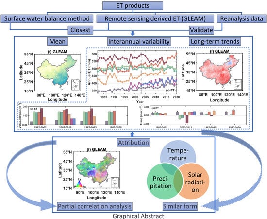
Figure 9 presents the annual time series of eight ET products and their corresponding input, i.e., precipitation, radiation, and temperature from 1982 to 2020. In addition to the six ET products (ERA5, ERA5-Land, MERRA2, MERRA-Land, MERRA, and GLEAM), two ET datasets obtained using the surface water balance method (WB, and WB-TWSA) are included, with WB-TWSA serving as the reference ET product to validate the other seven ET products. The overlapping period for the ET time series of all datasets is from 2003 to 2015. Figure 10a,b represent Taylor diagrams for various ET datasets during the time series of 2003–2015 and 1982–2015, respectively. Figure 11 summarizes the multi-year average values and trends of each ET product from 1982 to 2020.
From Figure 9a and Figure 11a,e, it can be observed that there are significant differences among the ET products in terms of multi-year annual averages, interannual variability, and long-term trends. From 2003 to 2015, WB and WB-TWSA have a similar annual average value of around 400 mm yr−1, and their trends are also very similar, indicating that the variation in surface water storage has a minimal impact on annual ET. Therefore, it is suitable to neglect water storage change at an annual scale, as widely used in previous studies [29,59]. Compared to WB-TWSA, the remote sensing derived GLEAM is the closest, with an annual average of 373.21 mm yr−1. The reanalysis products show a significant overestimation, with the multi-year average of ET ranging from 466.13 to 562.31 mm yr−1 from 1982 to 2015. Among them, MERRA has the most pronounced overestimation, reaching 40%, while MERRA-Land has the least overestimation, but still reached 16%. This overestimation of ET by the reanalysis products is consistent with the findings in Figure 2 and Figure 3.
Figure 10a,b were generated using WB-TWSA and GLEAM as reference datasets. The Taylor diagrams provide a quantitative assessment of how closely each ET dataset matches the reference data, with better model performance indicated by closer proximity to the reference dataset in the diagrams. In the results, it is observed that MERRA exhibits negative correlations with the reference data in both time periods, accompanied by relatively large standard deviations and root mean square errors (RMSEs). This suggests poor model performance for MERRA in the corresponding time series. During the period of 2003–2015, ERA5, while having standard deviations similar to the reference dataset, still shows negative correlations with the validation data and relatively high RMSE. On the other hand, the modeling performance of WB, GLEAM, MERRA2, MERRA-Land, and ERA5-Land appears relatively better. Among these, GLEAM stands out as it combines the best performance in all three parameters in the Taylor diagram, making it the chosen reference dataset for the 1982–2015 time frame. For the 1982–2015 period, ERA5 and ERA5-Land perform well, particularly in terms of standard deviations and RMSE. However, they exhibit lower correlations with GLEAM. In contrast, MERRA2 and MERRA-Land show higher correlations with the reference data but come with larger standard deviations and RMSEs. In summary, the land surface reanalysis datasets tend to outperform the atmospheric reanalysis datasets in terms of modeling capability. Please note that these observations are based on the analysis of the Taylor diagrams for the specified time periods and reference datasets.
Among the input data of the ET products, GLEAM shows the closest agreement with observed precipitation in all time periods, followed by MERRA2 and MERRA-Land. However, ERA5, ERA5-Land, and MERRA exhibit a significant overestimation in their multi-year average precipitation. Compared to observed solar radiation, GLEAM still shows the closest agreement, while the reanalysis products consistently exhibit significant overestimation, with the MERRA series having higher values than the ERA5 series. In comparison to observed temperature, all products show an underestimation.
In terms of interannual variability, the ET products exhibited significant annual fluctuations. WB-TWSA has the largest interannual variability, at around 40 mm yr−1, while GLEAM, ERA5, and ERA5-Land have smaller fluctuations, around 30 mm yr-1. MERRA, MERRA2, and MERRA-Land have the highest interannual variability, reaching up to 70 mm yr−1. Regarding the trends, from 2003 to 2015, the water balance ET products WB and WB-TWSA show a significant increasing trend, at 1.36 mm yr−2 (p = 0.29) and 1.60 mm yr−2 (p = 0.09), respectively. The increasing ET in China has been widely reported in previous studies [84,85,86]. Among the other products, GLEAM, MERRA2, and MERRA-Land exhibit a consistent increasing trend, at 1.24 mm yr−2 (p = 0.03), 1.34 mm yr−2 (p = 0.17), and 1.35 mm yr−2 (p = 0.11), respectively. The superior accuracy of MERRA2 may be attributed to the measures used to minimize the spurious variations related to inhomogeneity in the observation record [87]. In contrast, MERRA, ERA5, and ERA5-Land show a decreasing trend, with MERRA experiencing a significant decline of −3.69 mm yr−2 (p = 0.01). Figure 11f shows that the increase in ET based on the water balance approach is primarily attributed to the observed increase in precipitation, as there are no significant changes in radiation and temperature. The role of precipitation in determining ET changes is consistent with the finding by Fu, Gong [86]. Among all the products, only GLEAM, MERRA2, and MERRA-Land are able to reproduce the increasing trend in observed precipitation, which may explain why these three ET products perform well. A comparison of multi reanalysis datasets also indicates that precipitation is best represented by MERRA2 across China [88].
Compared to the water balance ET products, GLEAM ET demonstrates the best performance in terms of average values, interannual variability, and trend, mainly due to the high accuracy of its precipitation, radiation, and temperature products. MERRA2 and MERRA-Land exhibit a pronounced overestimation in average values, with significant interannual variability, but they can capture the consistent increasing trend observed in water balance ET, which is attributed to their ability to reproduce the observed changes in precipitation. On the other hand, ERA5, ERA5-Land, and MERRA exhibit a clear decreasing trend in ET, primarily due to the simulated decline in precipitation.
5. Discussion
Compared to GLEAM ET and water balance ET, all reanalysis products tend to overestimate ET on a national scale, particularly in humid and semi-humid regions. Among the atmospheric reanalysis products, MERRA and MERRA2 exhibit the most pronounced overestimation, while MERRA-Land is relatively closer to GLEAM. Compared to MERRA, MERRA2 has made improvements in forecasting models, analysis methods, and observational systems [28]. It has also corrected precipitation based on observational data, and previous studies have found significant improvements in land surface simulations with MERRA2 [32,52,53]. MERRA-Land corrects MERRA’s rainfall product using observational data, which improves rainfall accuracy [39]. However, in this study, it was observed that the degree of improvement in precipitation simulation accuracy had different impacts on the ET estimation accuracy between these two products, with MERRA2 not performing as well as MERRA-Land. The superior accuracy of land surface reanalysis data than atmospheric reanalysis data in ET simulation has been demonstrated in previous studies [29]. ERA5 and ERA5-Land show consistent spatial distributions, likely due to ERA5-Land being downscaled directly from ERA5 [38].
All the reanalysis ET datasets used in this study could reproduce the similar climatology and spatial pattern of multiyear average ET, while indicating substantial discrepancies in depicting interannual variability and trends, consistent with previous studies that different ET products indicate dramatically different performance across China [25,42,89,90]. In the four periods (1982–2002, 2003–2015, 1982–2015 and 1982–2020), both GLEAM and MERRA2 indicate obvious increasing ET trends, consistent with most findings [13,22,33,85,91,92]. MERRA2-Land can obtain similar increasing trends in the first three periods owing to the unavailability in the fourth time period. MERRA, ERA5 and ERA5-Land ET products perform differently in the different time periods, which indicate their unstable accuracy. The different performance in simulation of ET should be due to the different accuracy in simulating the three main determining factors (precipitation, solar radiation and air temperature), as these three factors indicate much difference in depicting trends. The significant discrepancy in spatial pattern of partial correlation analysis between three factors and ET can explain their difference in ET accuracy.
Specifically, at a national scale, among all the reanalysis ET products, only MERRA2 and MERRA-Land can also reproduce the consistent increasing trend at a similar increasing rate as water balance ET during the common period of 2003–2015. The attribution analysis indicate that this is mainly because these two products can simulate precipitation changes that are consistent with observations and show a significant increasing trend nationwide. However, ERA5 and ERA5-Land show a decreasing trend in ET, primarily because they fail to simulate the increasing trend in precipitation, possibly due to the absence of aerosol assimilation [75,93]. From 1982 to 2020, both GLEAM and MERRA2 ET exhibit a significant increasing trend attributed to the significant increases in precipitation and temperature during this period.
The differences in the accuracy of ET products have significant potential implications across various domains [94,95]. In terms of water resource management, the use of different ET products can lead to varying results, affecting the assessment of available water resources [95]. This can have substantial consequences for water resource planning and allocation. Additionally, ET serves as a critical indicator in drought monitoring [96,97]. Inaccurate ET estimations may result in misjudgments or delays in responding to drought conditions, impacting measures and resource allocation for drought mitigation. Agriculture, which heavily relies on water resources, is similarly affected. The accuracy of ET data directly influences irrigation planning and execution [98]. Inaccurate ET estimations can lead to the wastage or insufficiency of water resources. Furthermore, crop growth and yield are closely related to soil moisture levels. Accurate ET data help optimize irrigation plans, enhance crop yields, and reduce agricultural risks [99]. Moreover, ET is a crucial process within the climate system and plays a vital role in climate prediction and modeling [94,100]. Inaccurate ET estimations can introduce biases into climate models, subsequently affecting the accuracy of climate predictions. Research on climate change trends requires precise ET data. If significant differences exist among ET products, this can impact our understanding and prediction of climate change. Therefore, in these domains, selecting appropriate sources of ET data and understanding the differences in their accuracy are of paramount importance.
This study conducted a detailed accuracy evaluation of different ET products. However, it should be noted that this study tries to answer the question why the reanalysis differ in the performance of ET from the aspect of its main climate control variables and neglect the impact of other factors, such as vegetation impact [61,101,102], land use/cover changes [62,103], carbon dioxide effect [104,105] and aerosol effect [106,107], which should be investigated in detail in future studies to provide a more comprehensive understanding of the disparities in different ET products’ performance.
6. Conclusions
Based on the water balance product and the remote sensing-derived ET product GLEAM, we evaluated the ability of different reanalysis products to reproduce the spatiotemporal distribution and long-term trends of ET in China. We investigated the possible reasons for their performance disparity by analyzing the three major climatic factors influencing ET (precipitation, solar radiation, and temperature). The findings reveal that compared to the water balance ET, GLEAM product is capable of reproducing the mean, interannual variability, and trends of ET, making it suitable for validating reanalysis ET products. In comparison to GLEAM ET, all reanalysis ET products exhibit consistent climatology and spatial distribution but show a clear overestimation, with multi-year averages being overestimated by 16–40%. There are significant differences among the reanalysis products in terms of interannual variability, long-term trends, and attribution. Within the common period of 2003–2015, GLEAM shows a consistent increasing trend with the water balance ET. Among all the reanalysis ET products, only MERRA2 and MERRA-Land can also reproduce the consistent increasing trend at a similar increasing rate. This is mainly because these two products simulate precipitation that is consistent with GLEAM and shows a significant increasing trend nationwide. However, ERA5 and ERA5-Land show a decreasing trend in ET, primarily because they fail to simulate the increasing trend in precipitation, possibly due to the absence of aerosol assimilation. From 1982 to 2020, both GLEAM and MERRA2 ET exhibit a significant increasing trend attributed to the significant increases in precipitation and temperature during this period. The findings of this study are of great significance for the development of reanalysis products, improvement of ET simulation accuracy, and accurate assessment of the impact of climate change on the water cycle.
Author Contributions
Conceptualization, Y.M.; methodology, Y.M.; formal analysis, J.B.; writing—original draft preparation, J.B.; writing—review and editing, Y.M.; supervision, G.W. All authors have read and agreed to the published version of the manuscript.
Funding
This research was funded by the National Natural Science Foundation of China (No. 42005127). This research is also funded by National Basic Research Program of China (No. 2020YFA0608201) and the National Basic Research Program of China (No. 2022YFF0801301).
Data Availability Statement
Publicly available datasets were analyzed in this study. The GLEAM data can be downloaded from https://www.gleam.eu/ (accessed on 24 August 2022). The precipitation input data for the GLEAM model can be downloaded from https://www.gloh2o.org/mswep/ (accessed on 24 August 2022). The solar radiation and air temperature input data for the GLEAM model can be obtained from https://www.gloh2o.org/mswx/ (accessed on 8 November 2022). ERA5 and ERA5-Land data can be download from https://www.ecmwf.int/ (accessed on 7 July 2022). MERRA, MERRA2 and MERRA-Land data can be downloaded from https://gmao.gsfc.nasa.gov/ (accessed on 11 July 2022).
Conflicts of Interest
The authors declare no conflict of interest.
References
- Fisher, J.B.; Whittaker, R.J.; Malhi, Y. Et come home: Potential evapotranspiration in geographical ecology. Glob. Ecol. Biogeogr. 2011, 20, 1–18. [Google Scholar] [CrossRef]
- Wang, K.; Dickinson, R.E. A review of global terrestrial evapotranspiration: Observation, modeling, climatology, and climatic variability. Rev. Geophys. 2012, 50. [Google Scholar] [CrossRef]
- Shao, X.; Zhang, Y.; Liu, C.; Chiew, F.; Tian, J.; Ma, N.; Zhang, X. Can indirect evaluation methods and their fusion products reduce uncertainty in actual evapotranspiration estimates? Water Resour. Res. 2022, 58, e2021WR031069. [Google Scholar] [CrossRef]
- Zhang, J.; Bai, Y.; Yan, H.; Guo, H.; Yang, S.; Wang, J. Linking observation, modelling and satellite-based estimation of global land evapotranspiration. Big Earth Data 2020, 4, 94–127. [Google Scholar] [CrossRef]
- Dickinson, R.E.; Henderson-Sellers, A.; Rosenzweig, C.; Sellers, P.J. Evapotranspiration models with canopy resistance for use in climate models, a review. Agric. For. Meteorol. 1991, 54, 373–388. [Google Scholar] [CrossRef]
- Li, Z.-L.; Tang, R.; Wan, Z.; Bi, Y.; Zhou, C.; Tang, B.; Yan, G.; Zhang, X. A review of current methodologies for regional evapotranspiration estimation from remotely sensed data. Sensors 2009, 9, 3801–3853. [Google Scholar] [CrossRef]
- Liu, Y.; Qiu, G.; Zhang, H.; Yang, Y.; Zhang, Y.; Wang, Q.; Zhao, W.; Jia, L.; Ji, X.; Xiong, Y.; et al. Shifting from homogeneous to heterogeneous surfaces in estimating terrestrial evapotranspiration: Review and perspectives. Sci. China Earth Sci. 2022, 65, 197–214. [Google Scholar] [CrossRef]
- Pereira, L.S.; Perrier, A.; Allen, R.G.; Alves, I. Evapotranspiration: Concepts and future trends. J. Irrig. Drain. Eng. 1999, 125, 45–51. [Google Scholar] [CrossRef]
- Miralles, D.G.; Jiménez, C.; Jung, M.; Michel, D.; Ershadi, A.; McCabe, M.F.; Hirschi, M.; Martens, B.; Dolman, A.J.; Fisher, J.B.; et al. The wacmos-et project—Part 2: Evaluation of global terrestrial evaporation data sets. Hydrol. Earth Syst. Sci. 2016, 20, 823–842. [Google Scholar] [CrossRef]
- Cao, M.; Wang, W.; Xing, W.; Wei, J.; Chen, X.; Li, J.; Shao, Q. Multiple sources of uncertainties in satellite retrieval of terrestrial actual evapotranspiration. J. Hydrol. 2021, 601, 126642. [Google Scholar] [CrossRef]
- Pan, S.; Pan, N.; Tian, H.; Friedlingstein, P.; Sitch, S.; Shi, H.; Arora, V.K.; Haverd, V.; Jain, A.K.; Kato, E.; et al. Evaluation of global terrestrial evapotranspiration using state-of-the-art approaches in remote sensing, machine learning and land surface modeling. Hydrol. Earth Syst. Sci. 2020, 24, 1485–1509. [Google Scholar] [CrossRef]
- Li, X.Y.; He, Y.; Zeng, Z.Z.; Lian, X.; Wang, X.H.; Du, M.Y.; Jia, G.S.; Li, Y.N.; Ma, Y.M.; Tang, Y.H.; et al. Spatiotemporal pattern of terrestrial evapotranspiration in China during the past thirty years. Agric. For. Meteorol. 2018, 259, 131–140. [Google Scholar] [CrossRef]
- Khan, M.S.; Liaqat, U.W.; Baik, J.; Choi, M. Stand-alone uncertainty characterization of gleam, gldas and mod16 evapotranspiration products using an extended triple collocation approach. Agric. For. Meteorol. 2018, 252, 256–268. [Google Scholar] [CrossRef]
- Bai, P.; Liu, X. Intercomparison and evaluation of three global high-resolution evapotranspiration products across China. J. Hydrol. 2018, 566, 743–755. [Google Scholar] [CrossRef]
- Mueller, B.; Seneviratne, S.I.; Jimenez, C.; Corti, T.; Hirschi, M.; Balsamo, G.; Ciais, P.; Dirmeyer, P.; Fisher, J.B.; Guo, Z.; et al. Evaluation of global observations-based evapotranspiration datasets and ipcc ar4 simulations. Geophys. Res. Lett. 2011, 38. [Google Scholar] [CrossRef]
- Xie, Z.; Yao, Y.; Zhang, X.; Liang, S.; Fisher, J.B.; Chen, J.; Jia, K.; Shang, K.; Yang, J.; Yu, R.; et al. The global land surface satellite (glass) evapotranspiration product version 5.0: Algorithm development and preliminary validation. J. Hydrol. 2022, 610, 127990. [Google Scholar] [CrossRef]
- Ma, N.; Szilagyi, J.; Zhang, Y. Calibration-free complementary relationship estimates terrestrial evapotranspiration globally. Water Resour. Res. 2021, 57, e2021WR029691. [Google Scholar] [CrossRef]
- Mueller, B.; Hirschi, M.; Jimenez, C.; Ciais, P.; Dirmeyer, P.A.; Dolman, A.J.; Fisher, J.B.; Jung, M.; Ludwig, F.; Maignan, F.; et al. Benchmark products for land evapotranspiration: Landflux-eval multi-data set synthesis. Hydrol. Earth Syst. Sci. 2013, 17, 3707–3720. [Google Scholar] [CrossRef]
- Chen, X.; Su, Z.; Ma, Y.; Trigo, I.; Gentine, P. Remote sensing of global daily evapotranspiration based on a surface energy balance method and reanalysis data. J. Geophys. Res. Atmos. 2021, 126, e2020JD032873. [Google Scholar] [CrossRef]
- Feng, T.; Su, T.; Ji, F.; Zhi, R.; Han, Z. Temporal characteristics of actual evapotranspiration over China under global warming. J. Geophys. Res. Atmos. 2018, 123, 5845–5858. [Google Scholar] [CrossRef]
- Liu, W.; Wang, L.; Zhou, J.; Li, Y.; Sun, F.; Fu, G.; Li, X.; Sang, Y.-F. A worldwide evaluation of basin-scale evapotranspiration estimates against the water balance method. J. Hydrol. 2016, 538, 82–95. [Google Scholar] [CrossRef]
- Seo, K.-W.; Waliser, D.E.; Tian, B.; Kim, B.-M.; Park, S.-C.; Cocke, S.; Sohn, B.-J.; Ishii, M. Evidence of the recent decade change in global fresh water discharge and evapotranspiration revealed by reanalysis and satellite observations. Asia-Pac. J. Atmos. Sci. 2012, 48, 153–158. [Google Scholar] [CrossRef]
- Baatz, R.; Hendricks Franssen, H.J.; Euskirchen, E.; Sihi, D.; Dietze, M.; Ciavatta, S.; Fennel, K.; Beck, H.; De Lannoy, G.; Pauwels, V.R.N.; et al. Reanalysis in earth system science: Toward terrestrial ecosystem reanalysis. Rev. Geophys. 2021, 59, e2020RG000715. [Google Scholar] [CrossRef]
- Gokmen, M. Spatio-temporal trends in the hydroclimate of turkey for the last decades based on two reanalysis datasets. Hydrol. Earth Syst. Sci. Discuss. 2016, 20, 3777–3788. [Google Scholar] [CrossRef]
- Jiménez, C.; Prigent, C.; Mueller, B.; Seneviratne, S.I.; McCabe, M.F.; Wood, E.F.; Rossow, W.B.; Balsamo, G.; Betts, A.K.; Dirmeyer, P.A.; et al. Global intercomparison of 12 land surface heat flux estimates. J. Geophys. Res. Atmos. 2011, 116, 3–25. [Google Scholar] [CrossRef]
- ECMWF. Ifs documentation cy45r1—Part iv: Physical processes. In Ifs Documentation cy45r1, 4th ed.; ECMWF: Reading, UK, 2018. [Google Scholar]
- Hersbach, H.; Bell, B.; Berrisford, P.; Hirahara, S.; Horányi, A.; Muñoz-Sabater, J.; Nicolas, J.; Peubey, C.; Radu, R.; Schepers, D.; et al. The era5 global reanalysis. Q. J. R. Meteorol. Soc. 2020, 146, 1999–2049. [Google Scholar] [CrossRef]
- Gelaro, R.; McCarty, W.; Suarez, M.J.; Todling, R.; Molod, A.; Takacs, L.; Randles, C.; Darmenov, A.; Bosilovich, M.G.; Reichle, R.; et al. The modern-era retrospective analysis for research and applications, version 2 (merra-2). J. Clim. 2017, 30, 5419–5454. [Google Scholar] [CrossRef]
- Mao, Y.; Wang, K. Comparison of evapotranspiration estimates based on the surface water balance, modified penman-monteith model, and reanalysis data sets for continental China. J. Geophys. Res. Atmos. 2017, 122, 3228–3244. [Google Scholar] [CrossRef]
- Su, T.; Feng, G. Spatial-temporal variation characteristics of global evaporation revealed by eight reanalyses. Sci. China Earth Sci. 2015, 58, 255–269. [Google Scholar] [CrossRef]
- Baker, J.C.A.; Garcia-Carreras, L.; Gloor, M.; Marsham, J.H.; Buermann, W.; da Rocha, H.R.; Nobre, A.D.; de Araujo, A.C.; Spracklen, D.V. Evapotraanspiration in the amazon: Spatial patterns, seasonality, and recent trends in observations, reanalysis, and climate models. Hydrol. Earth Syst. Sci. 2021, 25, 2279–2300. [Google Scholar] [CrossRef]
- Dembélé, M.; Ceperley, N.; Zwart, S.J.; Salvadore, E.; Mariethoz, G.; Schaefli, B. Potential of satellite and reanalysis evaporation datasets for hydrological modelling under various model calibration strategies. Adv. Water Resour. 2020, 143, 103667. [Google Scholar] [CrossRef]
- Li, S.; Wang, G.; Sun, S.; Fiifi Tawia Hagan, D.; Chen, T.; Dolman, H.; Liu, Y. Long-term changes in evapotranspiration over china and attribution to climatic drivers during 1980–2010. J. Hydrol. 2021, 595, 126037. [Google Scholar] [CrossRef]
- Cheng, M.; Jiao, X.; Li, B.; Yu, X.; Shao, M.; Jin, X. Long time series of daily evapotranspiration in China based on the sebal model and multisource images and validation. Earth Syst. Sci. Data 2021, 13, 3995–4017. [Google Scholar] [CrossRef]
- Li, H.; Ye, A.; Zhang, Y.; Zhao, W. Intercomparison and evaluation of multisource soil moisture products in China. Earth Space Sci. 2021, 8, e2021EA001845. [Google Scholar] [CrossRef]
- Liu, C.; Deng, H.; Lu, Y.; Qiu, X.; Wang, D. Changes in “hotter and wetter” events across China. Theor. Appl. Climatol. 2017, 134, 1387–1397. [Google Scholar] [CrossRef]
- Rienecker, M.M.; Suarez, M.J.; Gelaro, R.; Todling, R.; Bacmeister, J.; Liu, E.; Bosilovich, M.G.; Schubert, S.D.; Takacs, L.; Kim, G.-K.; et al. Merra: Nasa’s modern-era retrospective analysis for research and applications. J. Clim. 2011, 24, 3624–3648. [Google Scholar] [CrossRef]
- Muñoz-Sabater, J.; Dutra, E.; Agustí-Panareda, A.; Albergel, C.; Arduini, G.; Balsamo, G.; Boussetta, S.; Choulga, M.; Harrigan, S.; Hersbach, H.; et al. Era5-land: A state-of-the-art global reanalysis dataset for land applications. Earth Syst. Sci. Data 2021, 13, 4349–4383. [Google Scholar] [CrossRef]
- Reichle, R.H.; Koster, R.D.; De Lannoy, G.J.; Forman, B.A.; Liu, Q.; Mahanama, S.P.; Touré, A. Assessment and enhancement of merra land surface hydrology estimates. J. Clim. 2011, 24, 6322–6338. [Google Scholar] [CrossRef]
- Martens, B.; Miralles, D.G.; Lievens, H.; van der Schalie, R.; de Jeu, R.A.M.; Fernández-Prieto, D.; Beck, H.E.; Dorigo, W.A.; Verhoest, N.E.C. Gleam v3: Satellite-based land evaporation and root-zone soil moisture. Geosci. Model Dev. 2017, 10, 1903–1925. [Google Scholar] [CrossRef]
- Mao, Y.; Wang, K.; Liu, X.; Liu, C. Water storage in reservoirs built from 1997 to 2014 significantly altered the calculated evapotranspiration trends over China. J. Geophys. Res. Atmos. 2016, 121, 10097–10112. [Google Scholar] [CrossRef]
- Zhu, W.; Tian, S.; Wei, J.; Jia, S.; Song, Z. Multi-scale evaluation of global evapotranspiration products derived from remote sensing images: Accuracy and uncertainty. J. Hydrol. 2022, 611, 127982. [Google Scholar] [CrossRef]
- Lu, J.; Wang, G.; Chen, T.; Shijie, L.; Hagan, D.; Kattel, G.; Peng, J.; Tong, J.; Buda, S. A harmonized global land evaporation dataset from reanalysis products covering 1980–2017. Earth Syst. Sci. Data Discuss. 2021, 13, 5879–5898. [Google Scholar] [CrossRef]
- Draper, C.S.; Reichle, R.H.; Koster, R.D. Assessment of merra-2 land surface energy flux estimates. J. Clim. 2018, 31, 671–691. [Google Scholar] [CrossRef]
- Wang, D.; Wang, G.; Parr, D.; Liao, W.; Xia, Y.; Fu, C. Incorporating remote sensing et into community land model version 4.5. Hydrol. Earth Syst. Sci. 2017, 21, 3557–3577. [Google Scholar] [CrossRef]
- Miralles, D.G.; Holmes, T.R.H.; De Jeu, R.A.M.; Gash, J.H.; Meesters, A.G.C.A.; Dolman, A.J. Global land-surface evaporation estimated from satellite-based observations. Hydrol. Earth Syst. Sci. 2011, 15, 453–469. [Google Scholar] [CrossRef]
- Balsamo, G.; Albergel, C.; Beljaars, A.; Boussetta, S.; Brun, E.; Cloke, H.; Dee, D.; Dutra, E.; Muñoz-Sabater, J.; Pappenberger, F.; et al. Era-interim/land: A global land surface reanalysis data set. Hydrol. Earth Syst. Sci. 2015, 19, 389–407. [Google Scholar] [CrossRef]
- Balsamo, G.; Beljaars, A.; Scipal, K.; Viterbo, P.; van den Hurk, B.; Hirschi, M.; Betts, A.K. A revised hydrology for the ecmwf model: Verification from field site to terrestrial water storage and impact in the integrated forecast system. J. Hydrometeorol. 2009, 10, 623–643. [Google Scholar] [CrossRef]
- Song, Y.Y.; Wei, J.F. Diurnal cycle of summer precipitation over the north China plain and associated land-atmosphere interactions: Evaluation of era5 and merra-2. Int. J. Climatol. 2021, 41, 6031–6046. [Google Scholar] [CrossRef]
- Mahto, S.S.; Mishra, V. Does era-5 outperform other reanalysis products for hydrologic applications in India? J. Geophys. Res. Atmos. 2019, 124, 9423–9441. [Google Scholar] [CrossRef]
- Albergel, C.; Dutra, E.; Munier, S.; Calvet, J.C.; Munoz-Sabater, J.; de Rosnay, P.; Balsamo, G. Era-5 and era-interim driven isba land surface model simulations: Which one performs better? Hydrol. Earth Syst. Sci. 2018, 22, 3515–3532. [Google Scholar] [CrossRef]
- Reichle, R.H.; Draper, C.S.; Liu, Q.; Girotto, M.; Mahanama, S.P.P.; Koster, R.D.; De Lannoy, G.J.M. Assessment of merra-2 land surface hydrology estimates. J. Clim. 2017, 30, 2937–2960. [Google Scholar] [CrossRef]
- Reichle, R.H.; Liu, Q.; Koster, R.D.; Draper, C.S.; Mahanama, S.P.P.; Partyka, G.S. Land surface precipitation in merra-2. J. Clim. 2017, 30, 1643–1664. [Google Scholar] [CrossRef]
- Zhihua, R.; Yu, Y.; Fengling, Z.; Yan, X. Quality detection of surface historical basic meteorological data. J. Appl. Meteorol. Sci. 2012, 23, 739–747. [Google Scholar]
- Wang, K.; Ma, Q.; Li, Z.; Wang, J. Decadal variability of surface incident solar radiation over China: Observations, satellite retrievals, and reanalyses. J. Geophys. Res. Atmos. 2015, 120, 6500–6514. [Google Scholar] [CrossRef]
- Wang, K. Measurement biases explain discrepancies between the observed and simulated decadal variability of surface incident solar radiation. Sci. Rep. 2014, 4, 6144. [Google Scholar] [CrossRef]
- Feng, F.; Wang, K. Merging ground-based sunshine duration observations with satellite cloud and aerosol retrievals to produce high-resolution long-term surface solar radiation over China. Earth Syst. Sci. Data 2021, 13, 907–922. [Google Scholar] [CrossRef]
- Dai, A.; Qian, T.; Trenberth, K.E.; Milliman, J.D. Changes in continental freshwater discharge from 1948 to 2004. J. Clim. 2009, 22, 2773–2792. [Google Scholar] [CrossRef]
- Gedney, N.; Cox, P.M.; Betts, R.A.; Boucher, O.; Huntingford, C.; Stott, P. Detection of a direct carbon dioxide effect in continental river runoff records. Nature 2006, 439, 835–838. [Google Scholar] [CrossRef]
- Piao, S.; Friedlingstein, P.; Ciais, P.; de Noblet-Ducoudré, N.; Labat, D.; Zaehle, S. Changes in climate and land use have a larger direct impact than rising co(2) on global river runoff trends. Proc. Natl. Acad. Sci. USA 2007, 104, 15242–15247. [Google Scholar] [CrossRef]
- Zhao, F.; Ma, S.; Wu, Y.; Qiu, L.; Wang, W.; Lian, Y.; Chen, J.; Sivakumar, B. The role of climate change and vegetation greening on evapotranspiration variation in the yellow river basin, China. Agric. For. Meteorol. 2022, 316, 108842. [Google Scholar] [CrossRef]
- Li, G.; Zhang, F.; Jing, Y.; Liu, Y.; Sun, G. Response of evapotranspiration to changes in land use and land cover and climate in China during 2001–2013. Sci. Total Environ. 2017, 596–597, 256–265. [Google Scholar] [CrossRef]
- Watkins, M.M.; Wiese, D.N.; Yuan, D.-N.; Boening, C.; Landerer, F.W. Improved methods for observing earth’s time variable mass distribution with grace using spherical cap mascons. J. Geophys. Res. Solid Earth 2015, 120, 2648–2671. [Google Scholar] [CrossRef]
- Zeng, Z.; Piao, S.; Lin, X.; Yin, G.; Peng, S.; Ciais, P.; Myneni, R.B. Global evapotranspiration over the past three decades: Estimation based on the water balance equation combined with empirical models. Environ. Res. Lett. 2012, 7, 014026. [Google Scholar] [CrossRef]
- Zeng, Z.; Wang, T.; Zhou, F.; Ciais, P.; Mao, J.; Shi, X.; Piao, S. A worldwide analysis of spatiotemporal changes in water balance-based evapotranspiration from 1982 to 2009. J. Geophys. Res. Atmos. 2014, 119, 1186–1202. [Google Scholar] [CrossRef]
- Taylor, K.E. Summarizing multiple aspects of model performance in a single diagram. J. Geophys. Res. Atmos. 2001, 106, 7183–7192. [Google Scholar] [CrossRef]
- Sun, R.; Duan, Q.; Wang, J. Understanding the spatial patterns of evapotranspiration estimates from land surface models over China. J. Hydrol. 2021, 595, 126021. [Google Scholar] [CrossRef]
- Liu, J.; Jia, B.; Xie, Z.; Shi, C. Ensemble simulation of land evapotranspiration in China based on a multi-forcing and multi-model approach. Adv. Atmos. Sci. 2016, 33, 673–684. [Google Scholar] [CrossRef]
- Kang, S.; Xu, Y.; You, Q.; Flügel, W.-A.; Pepin, N.; Yao, T. Review of climate and cryospheric change in the tibetan plateau. Environ. Res. Lett. 2010, 5, 015101. [Google Scholar] [CrossRef]
- Sh, W.; Yh, Y.; Zheng, D.; Qy, Y. Climate changes in tibetan plateau during the last three decades. Acta Geogr. Sin. 2005, 60, 3–11. [Google Scholar]
- Wu, G.; Duan, A.; Liu, Y.; Mao, J.; Ren, R.; Bao, Q.; He, B.; Liu, B.; Hu, W. Tibetan plateau climate dynamics: Recent research progress and outlook. Natl. Sci. Rev. 2014, 2, 100–116. [Google Scholar] [CrossRef]
- Nemani, R.R.; Keeling, C.D.; Hashimoto, H.; Jolly, W.M.; Piper, S.C.; Tucker, C.J.; Myneni, R.B.; Running, S.W. Climate-driven increases in global terrestrial net primary production from 1982 to 1999. Science 2003, 300, 1560–1563. [Google Scholar] [CrossRef] [PubMed]
- Teuling, A.J.; Hirschi, M.; Ohmura, A.; Wild, M.; Reichstein, M.; Ciais, P.; Buchmann, N.; Ammann, C.; Montagnani, L.; Richardson, A.D.; et al. A regional perspective on trends in continental evaporation. Geophys. Res. Lett. 2009, 36. [Google Scholar] [CrossRef]
- Beck, H.E.; van Dijk, A.I.J.M.; Larraondo, P.R.; McVicar, T.R.; Pan, M.; Dutra, E.; Miralles, D.G. Mswx: Global 3-hourly 0.1° bias-corrected meteorological data including near-real-time updates and forecast ensembles. Bull. Am. Meteorol. Soc. 2022, 103, E710–E732. [Google Scholar] [CrossRef]
- Feng, F.; Wang, K. Does the modern-era retrospective analysis for research and applications-2 aerosol reanalysis introduce an improvement in the simulation of surface solar radiation over China? Int. J. Climatol. 2019, 39, 1305–1318. [Google Scholar] [CrossRef]
- He, Y.; Wang, K.; Feng, F. Improvement of era5 over era-interim in simulating surface incident solar radiation throughout China. J. Clim. 2021, 34, 3853–3867. [Google Scholar] [CrossRef]
- Wang, Q.; Zhai, P.-M.; Qin, D.-H. New perspectives on ‘warming–wetting’ trend in xinjiang, China. Adv. Clim. Chang. Res. 2020, 11, 252–260. [Google Scholar] [CrossRef]
- Wu, P.; Ding, Y.; Liu, Y.; Li, X. The characteristics of moisture recycling and its impact on regional precipitation against the background of climate warming over northwest China. Int. J. Climatol. 2019, 39, 5241–5255. [Google Scholar] [CrossRef]
- Qian, W.; Lin, X. Regional trends in recent precipitation indices in China. Meteorol. Atmos. Phys. 2005, 90, 193–207. [Google Scholar] [CrossRef]
- Shi, Y.; Shen, Y.; Kang, E.; Li, D.; Ding, Y.; Zhang, G.; Hu, R. Recent and future climate change in northwest China. Clim. Chang. 2007, 80, 379–393. [Google Scholar] [CrossRef]
- Li, B.; Chen, Y.; Chen, Z.; Xiong, H.; Lian, L. Why does precipitation in northwest China show a significant increasing trend from 1960 to 2010? Atmos. Res. 2016, 167, 275–284. [Google Scholar] [CrossRef]
- Peng, D.; Zhou, T. Why was the arid and semiarid northwest China getting wetter in the recent decades? J. Geophys. Res. Atmos. 2017, 122, 9060–9075. [Google Scholar] [CrossRef]
- Su, T.; Feng, T.; Huang, B.; Han, Z.; Qian, Z.; Feng, G.; Hou, W. Trend, seasonal, and irregular variations in regional actual evapotranspiration over China: A multi-dataset analysis. Front. Phys. 2021, 9, 487. [Google Scholar] [CrossRef]
- Sun, S.; Liu, Y.; Chen, H.; Ju, W.; Xu, C.-Y.; Liu, Y.; Zhou, B.; Zhou, Y.; Zhou, Y.; Yu, M. Causes for the increases in both evapotranspiration and water yield over vegetated mainland China during the last two decades. Agric. For. Meteorol. 2022, 324, 109118. [Google Scholar] [CrossRef]
- Su, T.; Feng, T.; Huang, B.; Han, Z.; Qian, Z.; Feng, G.; Hou, W.; Dong, W. Long-term mean changes in actual evapotranspiration over China under climate warming and the attribution analysis within the budyko framework. Int. J. Climatol. 2022, 42, 1136–1147. [Google Scholar] [CrossRef]
- Fu, J.; Gong, Y.; Zheng, W.; Zou, J.; Zhang, M.; Zhang, Z.; Qin, J.; Liu, J.; Quan, B. Spatial-temporal variations of terrestrial evapotranspiration across China from 2000 to 2019. Sci. Total Environ. 2022, 825, 153951. [Google Scholar] [CrossRef]
- Bosilovich, M.G.; Robertson, F.R.; Takacs, L.; Molod, A.; Mocko, D. Atmospheric water balance and variability in the merra-2 reanalysis. J. Clim. 2017, 30, 1177–1196. [Google Scholar] [CrossRef]
- Long, D.; Longuevergne, L.; Scanlon, B.R. Uncertainty in evapotranspiration from land surface modeling, remote sensing, and grace satellites. Water Resour. Res. 2014, 50, 1131–1151. [Google Scholar] [CrossRef]
- Chen, Y.; Xia, J.; Liang, S.; Feng, J.; Fisher, J.B.; Li, X.; Li, X.; Liu, S.; Ma, Z.; Miyata, A.; et al. Comparison of satellite-based evapotranspiration models over terrestrial ecosystems in China. Remote Sens. Environ. 2014, 140, 279–293. [Google Scholar] [CrossRef]
- Wartenburger, R.; Seneviratne, S.I.; Hirschi, M.; Chang, J.; Ciais, P.; Deryng, D.; Elliott, J.; Folberth, C.; Gosling, S.N.; Gudmundsson, L.; et al. Evapotranspiration simulations in isimip2a—Evaluation of spatio-temporal characteristics with a comprehensive ensemble of independent datasets. Environ. Res. Lett. 2018, 13, 075001. [Google Scholar] [CrossRef]
- Zhang, F.; Geng, M.; Wu, Q.; Liang, Y. Study on the spatial-temporal variation in evapotranspiration in China from 1948 to 2018. Sci. Rep. 2020, 10, 17139. [Google Scholar] [CrossRef]
- Sun, S.; Chen, B.; Shao, Q.; Chen, J.; Liu, J.; Zhang, X.-J.; Zhang, H.; Lin, X. Modeling evapotranspiration over China’s landmass from 1979 to 2012 using multiple land surface models: Evaluations and analyses. J. Hydrometeorol. 2017, 18, 1185–1203. [Google Scholar] [CrossRef]
- Zhang, X.; Lu, N.; Jiang, H.; Yao, L. Evaluation of reanalysis surface incident solar radiation data in China. Sci. Rep. 2020, 10, 3494. [Google Scholar] [CrossRef] [PubMed]
- Fisher, J.B.; Melton, F.; Middleton, E.; Hain, C.; Anderson, M.; Allen, R.; McCabe, M.F.; Hook, S.; Baldocchi, D.; Townsend, P.A.; et al. The future of evapotranspiration: Global requirements for ecosystem functioning, carbon and climate feedbacks, agricultural management, and water resources. Water Resour. Res. 2017, 53, 2618–2626. [Google Scholar] [CrossRef]
- Anderson, M.C.; Allen, R.G.; Morse, A.; Kustas, W.P. Use of landsat thermal imagery in monitoring evapotranspiration and managing water resources. Remote Sens. Environ. 2012, 122, 50–65. [Google Scholar] [CrossRef]
- Otkin, J.A.; Anderson, M.C.; Hain, C.; Svoboda, M. Examining the relationship between drought development and rapid changes in the evaporative stress index. J. Hydrometeorol. 2014, 15, 938–956. [Google Scholar] [CrossRef]
- Kustas, W.P.; Mecikalski, J.R.; Pimstein, A.; Wardlow, B.; Hain, C.; Anderson, M.C. Evaluation of drought indices based on thermal remote sensing of evapotranspiration over the continental united states. J. Clim. 2011, 24, 2025–2044. [Google Scholar]
- Anderson, M.C.; Kustas, W.P.; Norman, J.M.; Hain, C.R.; Mecikalski, J.R.; Schultz, L.; González-Dugo, M.P.; Cammalleri, C.; d’Urso, G.; Pimstein, A.; et al. Mapping daily evapotranspiration at field to continental scales using geostationary and polar orbiting satellite imagery. Hydrol. Earth Syst. Sci. 2011, 15, 223–239. [Google Scholar] [CrossRef]
- Wang, H.; Zhang, L.; Dawes, W.R.; Liu, C. Improving water use efficiency of irrigated crops in the north China plain—Measurements and modelling. Agric. Water Manag. 2001, 48, 151–167. [Google Scholar] [CrossRef]
- Mao, J.; Fu, W.; Shi, X.; Ricciuto, D.M.; Fisher, J.B.; Dickinson, R.E.; Wei, Y.; Shem, W.; Piao, S.; Wang, K.; et al. Disentangling climatic and anthropogenic controls on global terrestrial evapotranspiration trends. Environ. Res. Lett. 2015, 10, 094008. [Google Scholar] [CrossRef]
- Wu, G.; Lu, X.; Zhao, W.; Cao, R.; Xie, W.; Wang, L.; Wang, Q.; Song, J.; Gao, S.; Li, S. The increasing contribution of greening to the terrestrial evapotranspiration in China. Ecol. Model. 2023, 477, 110273. [Google Scholar] [CrossRef]
- Zheng, H.; Miao, C.; Li, X.; Kong, D.; Gou, J.; Wu, J.; Zhang, S. Effects of vegetation changes and multiple environmental factors on evapotranspiration across China over the past 34 years. Earth’s Future 2022, 10, e2021EF002564. [Google Scholar] [CrossRef]
- Li, X.; Zou, L.; Xia, J.; Dou, M.; Li, H.; Song, Z. Untangling the effects of climate change and land use/cover change on spatiotemporal variation of evapotranspiration over China. J. Hydrol. 2022, 612, 128189. [Google Scholar] [CrossRef]
- Lemaitre-Basset, T.; Oudin, L.; Thirel, G. Evapotranspiration in hydrological models under rising co2: A jump into the unknown. Clim. Chang. 2022, 172, 36. [Google Scholar] [CrossRef]
- Cunliffe, A.M.; Boschetti, F.; Clement, R.; Sitch, S.; Anderson, K.; Duman, T.; Zhu, S.; Schlumpf, M.; Litvak, M.E.; Brazier, R.E.; et al. Strong correspondence in evapotranspiration and carbon dioxide fluxes between different eddy covariance systems enables quantification of landscape heterogeneity in dryland fluxes. J. Geophys. Res. Biogeosci. 2022, 127, e2021JG006240. [Google Scholar] [CrossRef]
- Zhou, H.; Yue, X.; Lei, Y.; Tian, C.; Ma, Y.; Cao, Y. Aerosol radiative and climatic effects on ecosystem productivity and evapotranspiration. Curr. Opin. Environ. Sci. Health 2021, 19, 100218. [Google Scholar] [CrossRef]
- Wang, B.; Yue, X.; Zhou, H.; Zhu, J. Impact of diffuse radiation on evapotranspiration and its coupling to carbon fluxes at global fluxnet sites. Agric. For. Meteorol. 2022, 322, 109006. [Google Scholar] [CrossRef]
Figure 1.
Research area map. The map depicts elevation data, geographical boundaries, and climate zones within China.
Figure 1.
Research area map. The map depicts elevation data, geographical boundaries, and climate zones within China.

Figure 2.
Climatology of six ET products (ERA5, ERA5-Land, MERRA2, MERRA-Land, MERRA, and GLEAM).

Figure 3.
Spatial pattern of multiyear average ET of six gridded products from 1982 to 2015. (a) ERA5, (b) ERA5-Land, (c) MERRA2, (d) MERRA-Land, (e) MERRA, and (f) GLEAM.
Figure 3.
Spatial pattern of multiyear average ET of six gridded products from 1982 to 2015. (a) ERA5, (b) ERA5-Land, (c) MERRA2, (d) MERRA-Land, (e) MERRA, and (f) GLEAM.

Figure 4.
Spatial pattern of long-term trends of six gridded ET products from 1982 to 2015. (a) ERA5, (b) ERA5-Land, (c) MERRA2, (d) MERRA-Land, (e) MERRA, and (f) GLEAM. The black dot in a grid indicates that the trends are statistically significant at a 95% (p < 0.05) confidence level.
Figure 4.
Spatial pattern of long-term trends of six gridded ET products from 1982 to 2015. (a) ERA5, (b) ERA5-Land, (c) MERRA2, (d) MERRA-Land, (e) MERRA, and (f) GLEAM. The black dot in a grid indicates that the trends are statistically significant at a 95% (p < 0.05) confidence level.

Figure 5.
Spatial pattern of long-term trends of precipitation input of seven gridded products from 1982 to 2015. (a) ERA5, (b) ERA5-Land, (c) MERRA2, (d) MERRA-Land, (e) MERRA, (f) GLEAM, and (g) observed precipitation. The black dot in a grid indicate that the trends are statistically significant at a 95% (p < 0.05) confidence level.

Figure 6.
Spatial pattern of long-term trends of surface incident solar radiation (Rs) input of six gridded products from 1982 to 2015. (a) ERA5, (b) ERA5-Land, (c) MERRA2, (d) MERRA-Land\MERRA, (e) GLEAM, and (f) SunDu-derived solar radiation. The black dot in a grid indicates that the trends are statistically significant at a 95% (p < 0.05) confidence level.

Figure 7.
Spatial pattern of long-term trends of air temperature input of six gridded products from 1982 to 2015. (a) ERA5, (b) ERA5-Land, (c) MERRA2, (d) MERRA-Land\MERRA, (e) GLEAM, and (f) observed air temperature. The black dot in a grid indicates that the trends are statistically significant at a 95% (p < 0.05) confidence level.

Figure 8.
Spatial distribution of three potential climatic constraints on ET: precipitation (P), surface incident solar radiation (Rs) and air temperature (Ta). (a) ERA5, (b) ERA5-Land, (c) MERRA2, (d) MERRA-Land, (e) MERRA, and (f) GLEAM. Each color corresponds to a unique combination of the partial correlations of the three constraints on ET.

Figure 9.
Annual time series of ET (a), precipitation (P) (b), surface incident solar radiation (Rs) (c), and air temperature (Ta) (d) in China.
Figure 9.
Annual time series of ET (a), precipitation (P) (b), surface incident solar radiation (Rs) (c), and air temperature (Ta) (d) in China.

Figure 10.
Taylor diagram of annual ET computed from each reanalysis dataset versus that computed from the reference dataset: (a) 2003–2015; (b) 1982–2015. Datasets with correlation coefficients less than 0 are omitted. In each plot, the distance between each colored dot which represents result of a reanalysis dataset while the hollow dot represents the result of the observed dataset, which is a measure of how well the statistics obtained for each reanalysis dataset agree with that of the observed dataset. For each reanalysis dataset, three statistics are presented, which are the correlation coefficient (blue lines), the centered root mean square error (green lines) and standard deviation (black lines).

Figure 11.
Annual average ET (a), precipitation (P) (b), surface incident solar radiation (Rs) (c), air temperature (Ta) (d), and trend of ET (e), P (f), Rs (g) and Ta (h) in the four time periods (1982–2002, 2003–2015, 1982–2015 and 1982–2020). In the figure, * indicates that the trends are statistically significant at a 95% (p < 0.05) confidence level.


Table 1.
The attribute information of eight ET datasets used in this study.
| Dataset | Data Type | Model | Input Data | Temporal Resolution | Spatial Resolution | Time Span | References |
|---|---|---|---|---|---|---|---|
| MERRA | Atmospheric reanalysis | GEOS-5 * CLSM * | Rs *, Ta *, P * | 3 Hourly | 0.5° × 0.667° | 1979–2019 | [37] |
| MERRA2 | Atmospheric reanalysis | GEOS 5.12.4 | Rs, Ta, P | Hourly | 0.5° × 0.625° | 1980–present | [28] |
| ERA5 | Atmospheric reanalysis | IFS * Cycle 41r2 CHTESSEL * | Rs, Ta, P | Hourly | 0.25° × 0.25° | 1950–present | [27] |
| ERA5- Land | Land surface reanalysis | IFS Cycle 45r1 CHTESSEL | Rs, Ta, P | Hourly | 0.1° × 0.1° | 1950–present | [38] |
| MERRA- Land | Land surface reanalysis | GEOS-5 CLSM | Rs, Ta, P | 3 Hourly | 0.5° × 0.667° | 1979–2015 | [39] |
| GLEAM | Remote Sensing retrieval | Priestley- Taylor equation Gash analysis model | Rs, Ta (MSWX) P (MSWEP * (v2.8)) soil moisture (ESA-CCI * v6.2) VODCA VOD | Daily | 0.25° × 0.25° | 1980–present | [40] |
| WB-TWSA | Water balance | Water balance equation | P and R from Water Resources Bulletin GRACE ΔTWSA | Annual | National scale | 1997–2020 | [41] |
| WB | Water balance | Water balance equation | P and R from Water Resources Bulletin | Annual | National scale | 1997–2020 | [41] |
* GEOS-5: Goddard Earth Observing System 5.2.0; CLSM: Catchment Land Surface Model; IFS: Integrated Forecast System; CHTESSEL: Carbon Hydrology-Tiled ECMWF Scheme for Surface Exchanges over Land; ESA-CCI: European Space Agency-Climate Change Initiative; MSWEP: Multi-Source Weighted-Ensemble Precipitation; Rs: Surface Incident Solar Radiation; Ta: Air temperature; P: Precipitation.
Disclaimer/Publisher’s Note: The statements, opinions and data contained in all publications are solely those of the individual author(s) and contributor(s) and not of MDPI and/or the editor(s). MDPI and/or the editor(s) disclaim responsibility for any injury to people or property resulting from any ideas, methods, instructions or products referred to in the content. |
© 2023 by the authors. Licensee MDPI, Basel, Switzerland. This article is an open access article distributed under the terms and conditions of the Creative Commons Attribution (CC BY) license (https://creativecommons.org/licenses/by/4.0/).
Share and Cite
MDPI and ACS Style
Bai, J.; Wu, G.; Mao, Y. Significant Disparity in Spatiotemporal Changes of Terrestrial Evapotranspiration across Reanalysis Datasets in China from 1982 to 2020. Remote Sens. 2023, 15, 4522. https://doi.org/10.3390/rs15184522
AMA Style
Bai J, Wu G, Mao Y. Significant Disparity in Spatiotemporal Changes of Terrestrial Evapotranspiration across Reanalysis Datasets in China from 1982 to 2020. Remote Sensing. 2023; 15(18):4522. https://doi.org/10.3390/rs15184522
Chicago/Turabian StyleBai, Jiaxin, Guocan Wu, and Yuna Mao. 2023. "Significant Disparity in Spatiotemporal Changes of Terrestrial Evapotranspiration across Reanalysis Datasets in China from 1982 to 2020" Remote Sensing 15, no. 18: 4522. https://doi.org/10.3390/rs15184522
Note that from the first issue of 2016, this journal uses article numbers instead of page numbers. See further details here.